Making the switch to save #water: Prairie grasses take root in first year of landscape transformation in Arapahoe County — News on Tap #conservation

Click the link to read the article on the Denver Water website (Jay Adams):

What a difference a year makes for the front of Arapahoe County’s Administration Building in Littleton.

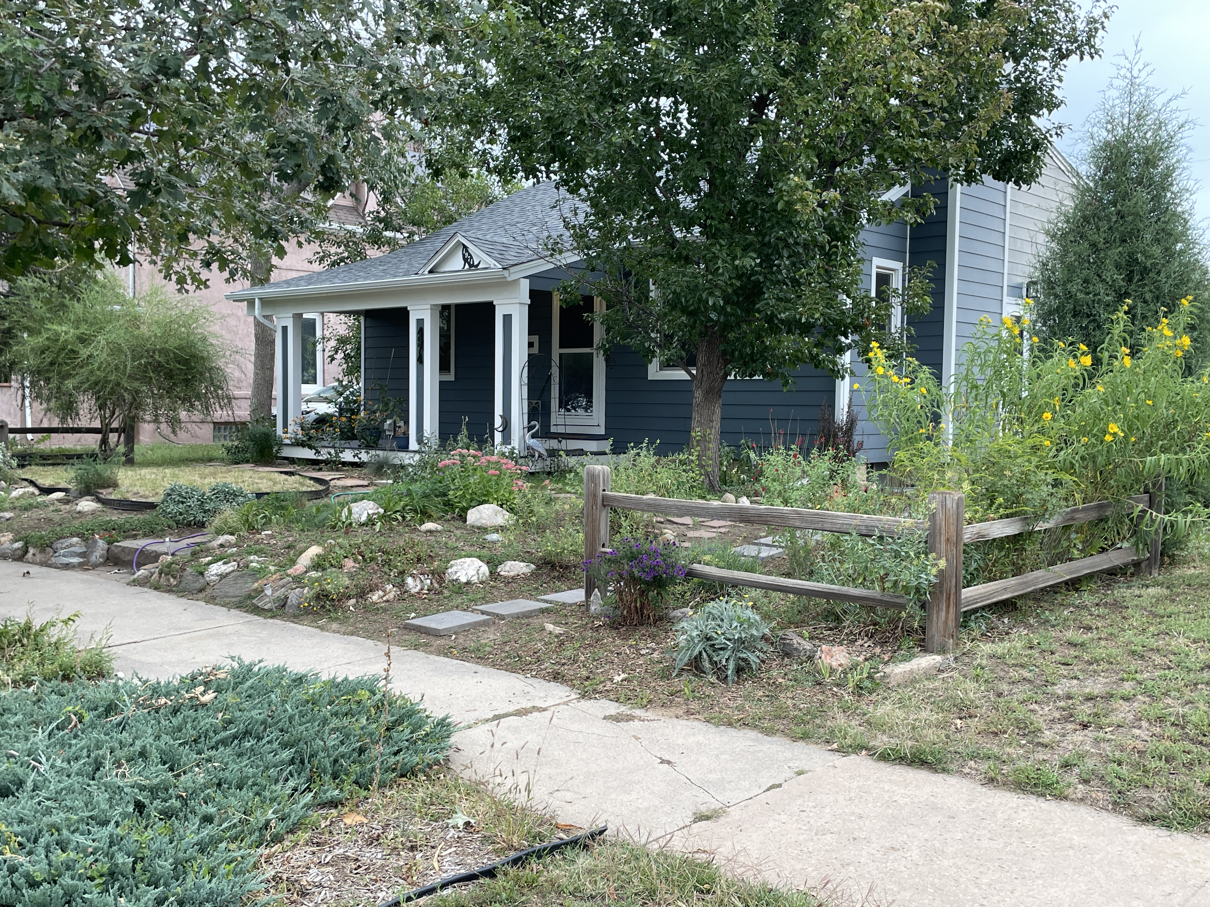
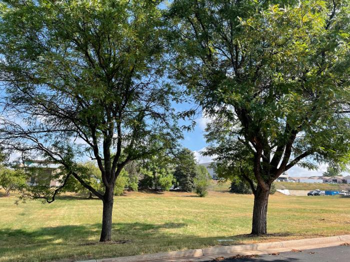
Since the 1970s, the west side of the building had been covered by a 3-acre field of unused, water-intensive Kentucky bluegrass.

Recognizing the need to set a positive example regarding water conservation for the long term, in August 2022 the Arapahoe County Commissioners launched a plan to seed the field with a mix of prairie grasses in an effort to transform the bland expanse of bluegrass into a more natural ColoradoScape that will use less water.


Learn more about ColoradoScaping at denverwater.org/Conserve.


The project is part of Arapahoe County’s broader sustainability initiative that includes reducing water consumption indoors and outdoors.

One year later, all the planning has paid off and the grasses are flourishing.

Arapahoe County’s Administration Building in Littleton has a new ColoradoScape with its prairie grass field on the west side of the building. The transformation is a part of the county’s sustainability efforts to reduce water consumption. Photo credit: Denver Water.

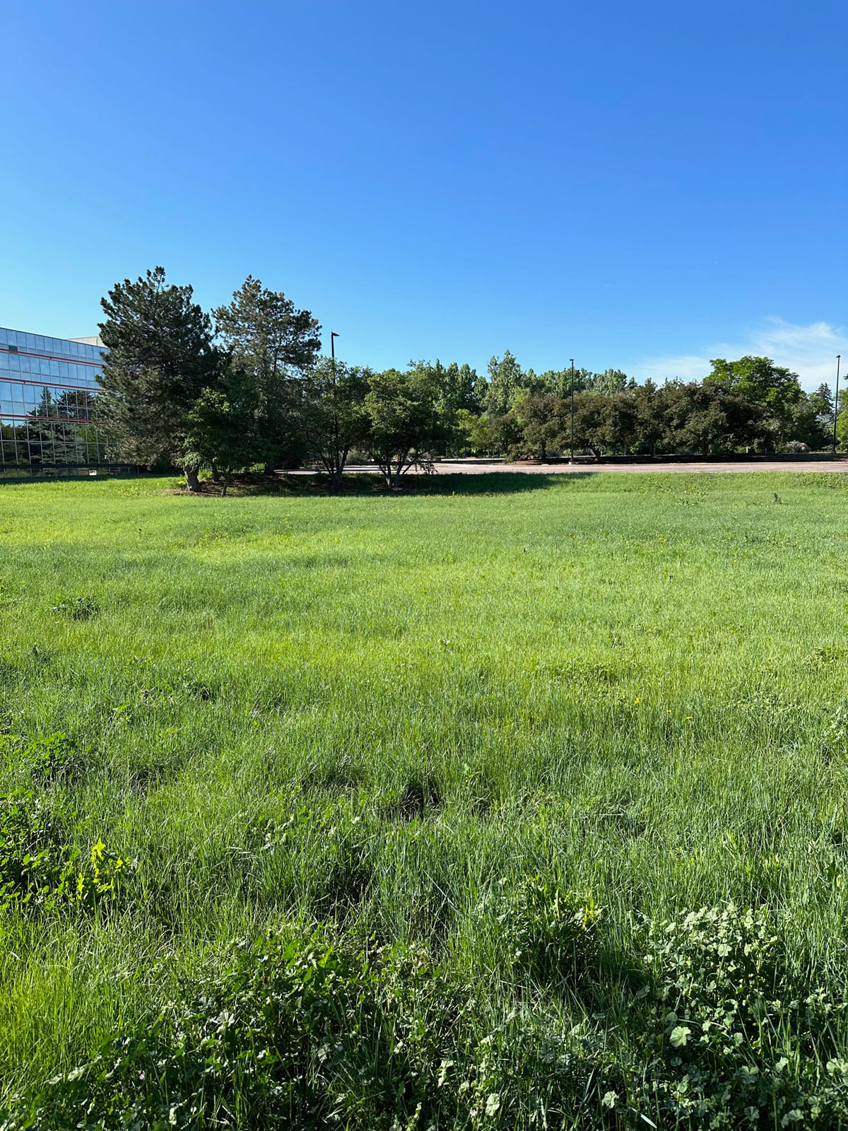
“We’re very pleased with how the grasses have come in and are thriving,” said Lisa VanderHeyden, senior project manager of facilities and fleet at Arapahoe County. “We were lucky and got a nice boost from Mother Nature with all the rain in May and June, which really helped the grasses grow in their first season.”

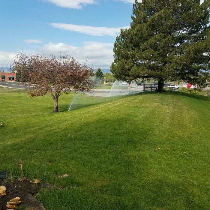
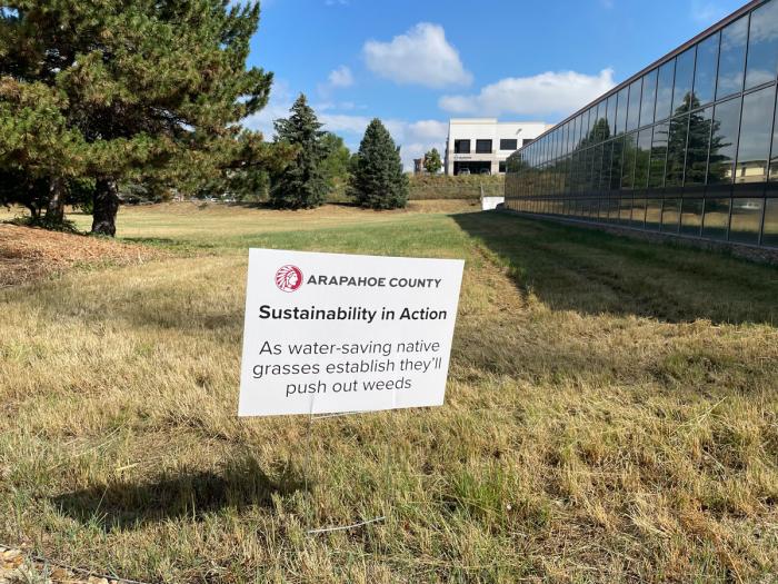
The old field was chosen for landscape transformation because it was considered to have “nonfunctional grass,” which is grass that requires frequent watering from an irrigation system but is not used for activities or events.

The old Kentucky bluegrass field as seen before the transformation in 2022. The field required extensive watering to stay green and was considered nonfunctional grass because it was not used for activities or events. Photo credit: Arapahoe County.

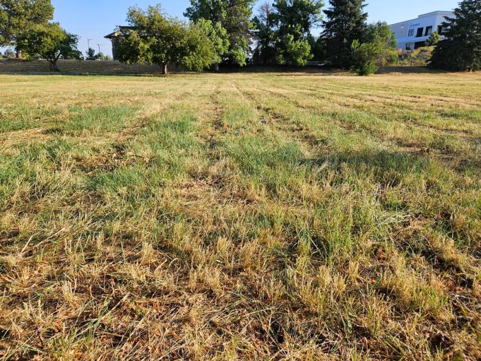
The new field contains a mix of grasses with varying heights and textures. It resembles what the field looked like before people settled the area and started irrigating the land.

It typically takes about three years to fully establish a native grass area, in which the grasses fill in and squeeze out the weeds. Once established, the grass should be able to survive solely on the moisture provided by Mother Nature.


This is how Arapahoe County’s ColoradoScape is going. See how it started.


Arapahoe County’s staff will actively manage the field and the county anticipates saving approximately 1.5 million gallons of water per season due to the switch from the bluegrass.

“The field will have a very natural look and, like other prairie grass fields in the area, the colors will change depending on the amount of precipitation throughout the year,” VanderHeyden said.

The field, seen here in August 2023 after it was mowed for the first time. The field, which will be mowed once a year, has a mix of native prairie grass seeds including blue grama, buffalo grass, sideoats grama, western wheatgrass, green needlegrass and sand dropseed. Photo credit: Denver Water.

Changing landscapes across the Southwest

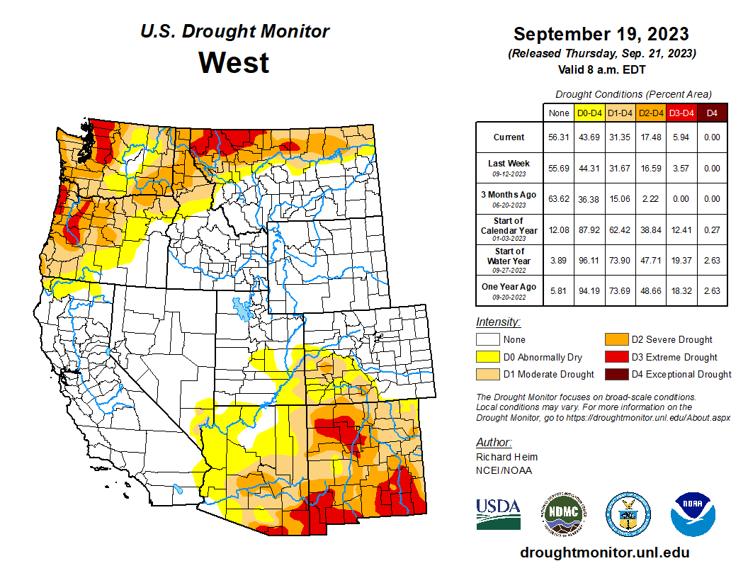
The building is in Denver Water’s service area and is a great example of a greater push across the Southwest to reduce the amount of nonfunctional grass and help boost the struggling Colorado River, where Denver Water gets half of its water supply.

“We’ve been really impressed with Arapahoe County’s efforts to examine their nonfunctional grass areas and make water-saving changes,” said Austin Krcmarik, water efficiency planner at Denver Water.

The landscape transformation in front of Arapahoe County’s Administration Building includes a garden that features low-water-use plants designed to do well in Colorado’s semi-arid climate. Photo credit: Denver Water.

“For decades, Kentucky bluegrass has been the default landscaping option for many government buildings and now we’re seeing a shift to more natural looking, water-saving ColoradoScapes.”

So, how do you start a new prairie grass field? Hear Arapahoe County officials discuss the project:

Creating a long-term plan

Krcmarik and Arapahoe County agree that there are a number of steps to take when doing large landscape transformation projects:

  • Check with the local water provider for ideas and resources.
  • Consult with the growing number of landscape experts who support water-saving transformations.
  • Work with landscapers who are willing to research what will work best and commit to support the transformation beyond the initial implementation.
  • Get the full support of management.
  • Think the project through, from start to finish and consider long-term maintenance.
Mature trees remain in front of the building. Arapahoe County has experimented with different types of irrigation techniques to ensure they stay healthy as irrigation to the field is reduced. Photo credit: Denver Water.
  • Inform the public about the reasons behind the landscape change.
  • Develop a plan for how to prepare the site for new seeds and plants.
  • Upgrade and/or modify irrigation systems to protect mature trees if the new landscape will use less water.
  • Develop a plan to manage weeds during the early years.
  • Choose plants that can survive without irrigation after establishment.

Denver Water and Arapahoe County are part of the Colorado Native Grass Working Group, which includes dozens of other cities, landscape and water professionals to put together a guide on best practices for installing low-water grass landscapes. You can check out their resources and sign up for their email list at coloradonativegrass.org.

Signs point out the challenges weeds present during landscape transformation. Grasses typically take around three years to become fully established and squeeze out the weeds. Photo credit: Denver Water.

State support

The turf replacement project was awarded a grant from the Colorado Water Conservation Board for supporting the Colorado Water Plan’s goal of encouraging municipalities to reduce water use through landscape change.

“It’s been great working with Denver Water, and we appreciate their support and also the grant from the CWCB,” said Anders Nelson, Arapahoe County public information officer.

“While this is a relatively small field, we hope to learn from our work, share and improve the processes and continue to look for other opportunities to reduce our water consumption here in Arapahoe County.”

Mrs. Gulch’s landscape September 14, 2023. Note the freshly mowed Blue gramma area at center left.

Douglas County Commissioner George Teal proposes campaign donors for Douglas County #water commission — #Colorado Politics

Potential Water Delivery Routes. Since this water will be exported from the San Luis Valley, the water will be fully reusable. In addition to being a renewable water supply, this is an important component of the RWR water supply and delivery plan. Reuse allows first-use water to be used to extinction, which means that this water, after first use, can be reused multiple times. Graphic credit: Renewable Water Resources

Click the link to read the article on the Colorado Politics website (Marianne Goodland). Here’s an excerpt:

A Douglas County commissioner recommended individuals who contributed to his campaign to sit on a new water commission that would be tasked with ensuring sufficient future water supply for the county. The individuals included two principals of a water development firm that has been trying to get buy-in for a proposal to pipe water from the San Luis Valley into Douglas County, a move that has been met with stiff opposition from governments in the valley.

Douglas County commissioners, from left: George Teal, Lora Thomas and Abe Laydon. Courtesy Douglas County

Douglas County’s commissioners met earlier this week to begin deciding who they would put on the new 11-member water commission, which will include three representatives of each district and two at-large members. The nominees were among those who submitted applications for the water commission, a list that has been kept confidential. 

During Monday’s discussion, Commissioner George Teal announced his eight picks for members: Three for his district, three for another district, plus two at-large members. Five of his picks have made substantial contributions to his political campaigns, including two principals from Renewable Water Resources, the firm that pitched moving water from San Luis Valley’s groundwater to Douglas County…On Aug. 13, 2021, Renewable Water Resources principals, their spouses and friends contributed to pay down Teal’s 2020 campaign debt. The contributions totaled $16,000. Among the funders were Tonner and John Kim, both RWR principals, and Craig Broughton, an associate of Tonner’s. All three are on Teal’s list for the water commission. He also named Castle Pines City Councilman Roger Hudson, who is deputy chief of staff for the House Minority caucus at the state Capitol and who also made several contributions to Teal’s campaign for the 2020 election. Teal also recommended Harold Smethills, who doesn’t live in Douglas County but owns property in Sterling Ranch. Smethills has also contributed to Teal’s campaign. In a previous discussion, Teal had proposed allowing people who don’t live in the county but own property there to apply for the water commission.

San Luis Valley Groundwater

#Drought news September 21, 2023: Rain trimmed D0 in southern #Colorado and contracted D0-D1 in southwestern #KS, half an inch to locally 2+ inches of rain fell over parts of #AZ, #NM, and #UT

Click on a thumbnail graphic to view a gallery of drought data from the US Drought Monitor website.

Click the link to go to the US Drought Monitor website. Here’s an excerpt:

This Week’s Drought Summary

Several Pacific weather systems moved through the jet-stream flow during this U.S. Drought Monitor (USDM) week (September 13-19). The upper-level circulation still consisted of an upper-level ridge over the western contiguous U.S. (CONUS), but it was weakened by the traversing Pacific weather systems. The ridge kept most of the western U.S. dry with warmer-than-normal temperatures from northern California to Montana. Cold fronts and surface low-pressure systems, that accompanied the weather systems, brought rain to the Southwest, southern Plains, Southeast, and Northeast. Heavy rain fell across western to central Texas, improving drought conditions. The rain in the East fell mostly on non-drought areas. The fronts kept temperatures cooler than normal from the Southwest to most of the southern Plains and across much of the country from the Mississippi River to East Coast – only the Gulf of Mexico coast and New England had a warmer-than-normal week. In addition to getting rain from frontal systems, parts of New England were soaked by the remnants of Hurricane Lee over the weekend. The northern Plains and parts of the central Plains, the Great Lakes, and the Mississippi and Ohio Valleys had a drier-than-normal week. The dryness this week was a continuation of dry conditions that have lasted for several months – in some cases for years – across parts of the country and that have dried out soils across more than half of the CONUS. According to U.S. Department of Agriculture statistics, 58% of the nation’s topsoil moisture and 59% of the subsoil moisture was dry or very dry. For topsoil moisture, based on data going back to 2015, this amount is second only to the drought of 2022, which peaked at 68%. The continued dry conditions resulted in expansion or intensification of drought and abnormal dryness across parts of the Mississippi and Ohio Valleys, Mid-Atlantic states, and Pacific Northwest…

High Plains

Half an inch to locally 2 inches of rain fell over western and southern parts of the High Plains region, mostly in Colorado, southern Kansas, and parts of Nebraska. But most of Wyoming, the Dakotas, Nebraska, and Kansas were dry this week. The rain trimmed D0 in southern Colorado and contracted D0-D1 in southwestern Kansas. D0 and D3 expanded in eastern Kansas. D0 expanded in parts of southwest Nebraska, but the compounded effects of excessive summer heat and overall dryness over the last 1 to 2 years resulted in expansion of D3 and D4 in parts of southeast Nebraska. Sporadic summer showers have not had much of an impact on the multi-year drought, with low soil moisture continuing and stressed vegetation as seen on satellite-based indicators. A farmer/rancher in Nuckolls County, Nebraska reported stock ponds had never gone dry in his 65 years living in the county until this summer and his crops were all burned up. Reports like this are typical across the region. According to USDA statistics, 50% or more of the topsoil moisture was short or very short in Kansas (68%), Nebraska (60%), North Dakota (51%), and South Dakota (50%), and 50% or more of the subsoil moisture was dry or very dry in Kansas (75%), Nebraska (65%), and North and South Dakota (52% each). Half (50%) of the pasture and rangeland in Kansas was in poor to very poor condition…

Colorado Drought Monitor one week change map ending September 19, 2023.

West

Half an inch to locally 2+ inches of rain fell over parts of Arizona, New Mexico, and Utah, but most of the West received no rain this week. High evapotranspiration due to persistently hot temperatures, low streamflow and soil moisture, and lack of precipitation over 1-month to 12-month time scales resulted in the expansion of D2 and D3 in northwest Washington, expansion of D2 in eastern Washington and the Idaho panhandle, and expansion of D1 and D2 and the introduction of D3 in western Oregon. Rain from weather systems in past weeks, especially the remnants of Hurricane Hilary, resulted in contraction of D1 in central Oregon, D0 and D1 in Utah, and D0 to D3 in western Montana. While parts of New Mexico received rain this week, other parts were dry. The weather system that dumped rain on Texas also soaked east-central New Mexico, so drought contracted there. But prolonged dryness resulted in expansion of D1 and D2 in central to northeast New Mexico and D3 in northwest and southern parts of the state, as well as D3 expansion in adjacent southeast Arizona. According to USDA reports, more than two-thirds of the topsoil was short or very short of moisture in New Mexico (87%), Washington (83%), Montana (82%), and Oregon (74%), and more than two-thirds of the subsoil moisture was short or very short in New Mexico (87%), Montana (79%), Washington (78%), and Oregon (75%). Half or more of the pasture and rangeland was in poor or very poor condition in Washington (65%) and Arizona (57%)…

South

A large part of Texas received over 2 inches of rain this week. These areas included western to central Texas and parts of the Southeast and Far South. Over 5 inches of rain was reported at stations near Lubbock, Austin, Houston, and Galveston Bay, with the CoCoRaHS station at Nassau Bay 0.9ENE reporting 9.57 inches. The rain resulted in the contraction of D1-D4 in western to central Texas and in the southeast and far south sections of the state. Areas of half an inch to 2 inches of rain occurred over parts of western and southern Oklahoma. But most of Arkansas and Mississippi, parts of Louisiana and eastern Oklahoma, and much of the Rio Grande Valley were dry this week. The compound effects of the excessive heat and dryness of the summer and early fall prompted expansion of abnormal dryness and moderate to exceptional drought in Mississippi, Louisiana, northeastern Texas, and southeast Oklahoma, with abnormal dryness and moderate drought expanding in Arkansas and eastern Oklahoma. The high evapotranspiration and lack of rain has dried out soils and resulted in impacts that include low or dry streams and cattle ponds, desiccated pasture and cropland, and stressed vegetation dropping leaves. Reports include: hay and grasses are short and insufficient for cattle; soils are so dry that the ground is as hard as concrete. Reports like this are typical across the region. According to USDA reports, topsoil moisture is short or very short across 80% of Louisiana, 74% of Mississippi, 72% of Oklahoma, 69% of Arkansas, and 59% of Texas. The subsoil moisture statistics are: 87% Louisiana, 73% Oklahoma and Texas, 67% Mississippi, and 55% Arkansas. Over 60% of the pasture and rangeland is in poor to very poor condition in Texas (71%) and Louisiana (68%), and over 40% in Oklahoma (49%) and Mississippi (41%)…

Looking Ahead

In the two days since the valid time of this USDM, rain has fallen across parts of the West, parts of the Plains to Mississippi Valley, and parts of Florida. For September 21-26, a strong weather system will slowly move out of the Rockies into the Plains and spread heavy rain across much of the Plains to Mississippi Valley, while a low-pressure system moves along the East Coast, spreading heavy rain to coastal areas, and a third Pacific weather system brings rain to coastal areas from northern California to Washington. Weekly precipitation totals could range from 1 to locally 5 inches or more in these regions. Other parts of the Far West, the Four Corners states, much of the Southeast, and the Appalachians to eastern Great Lakes are expected to receive little to no precipitation. Temperatures are expected to be warmer than normal across parts of the Plains to the Mississippi River Valley and Great Lakes.

The Climate Prediction Center’s (CPC) 6-10 Day Outlook (valid September 26-30) favors above-normal precipitation from northern California to North Dakota and across much of the Southeast, with below-normal precipitation centered over Colorado and extending from Missouri to the Great Lakes and New England. Odds favor near normal precipitation for Alaska. The outlook is for below-normal temperatures over southwest Alaska and the Far West in the CONUS, and above-normal temperatures from the Rockies to Appalachians and over northeast Alaska.

The temperature pattern favored in CPC’s 8-14 Day Outlook (valid September 28-October 4) is a continuation of that in the 6-10 Day Outlook, with cooler-than-normal temperatures extending to the Rocky Mountains and the warmer-than-normal area extending to the East Coast. The area favored for above-normal precipitation extends across the Great Plains, while the below-normal area extends to the Lower Mississippi Valley. Odds favor above-normal precipitation for most of Alaska.

US Drought Monitor one week change map ending September 19, 2023.