Click on a thumbnail graphic below to view a gallery of drought data from the US Drought Monitor website.

Click the link to go to the US Drought Monitor website. Here’s an excerpt:
This Week’s Drought Summary
Heavy rainfall associated with Hurricane Idalia brought damaging winds and flooding centered along its path. Idalia moved from the Gulf of Mexico inland along the northeastern Gulf Coast of Florida and continued northeastward through south-central and east-central Georgia, slightly inland from the South Carolina Coast, then across southeastern North Carolina before moving into the open waters of the northwestern Atlantic Ocean. A solid swath of heavy rains were observed in a band from the eastern Florida Panhandle northward through middle Georgia, interior eastern South Carolina, and southeastern North Carolina as far north as the lower Outer Banks. Between 4.5 to 10.0 inches of rain fell solidly along this swath of land, but rainfall totals dropped off rapidly to the west and east of the main band.
Farther west, a surge of tropical moisture pushed northward into the southwestern U.S., continuing northward across the Great Basin, Intermountain West, and adjacent Rockies into adjacent Canada. Heavy rainfall fell in a broken pattern over this general area, with the highest amounts reported across interior southeastern California, over much of the middle Colorado River Basin, and across scattered areas farther north. The heaviest amounts outside the lower Colorado River Basin fell on higher elevations and over areas where precipitation was enhanced by orography, as is typical.
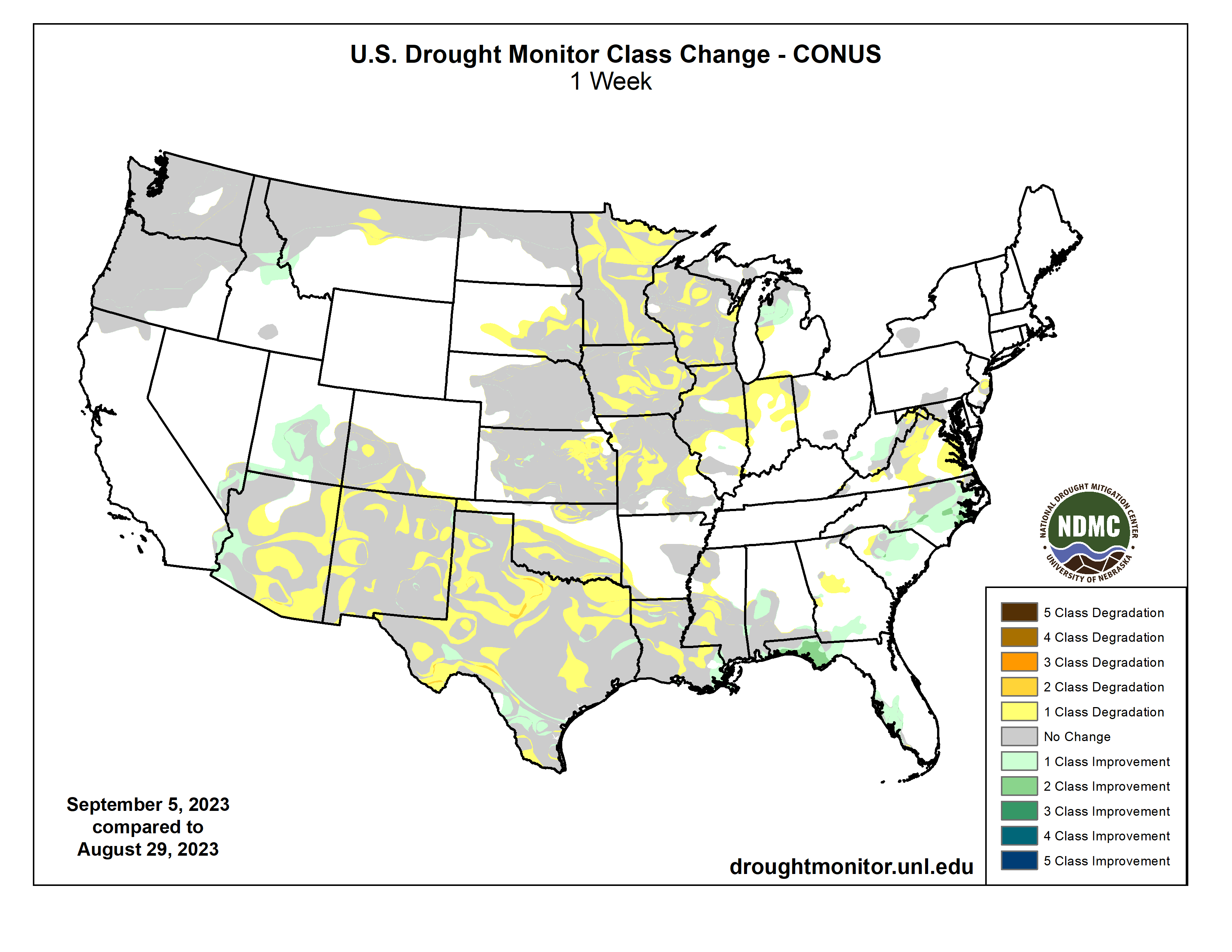
Most of the Nation, however, endured a hot and drier-than-normal week, including most areas of drought. Temperatures averaged 5 to 10 deg. F accompanied deficient precipitation over a large area from the Rockies to the Appalachians and central Gulf Coast Region, prompting drought intensification over large parts of the Upper Mississippi Valley, the Central States, and the southern tier of the country west of the Florida Panhandle. Improvement was limited to the band of heavy precipitation from Hurricane Idalia, and in scattered locales affected by the tropical moisture surge in the Desert Southwest, from southeastern Utah to central Arizona westward toward central California. According to the U.S. Department of Agriculture (USDA), the coverage of topsoils short or very short of moisture increased by 6 percent this past week, now covering 58 percent of the contiguous 48 states. This is the greatest coverage at this time of year in more than 9 years, the prior record in that short interim being just over 50 percent in 2020…
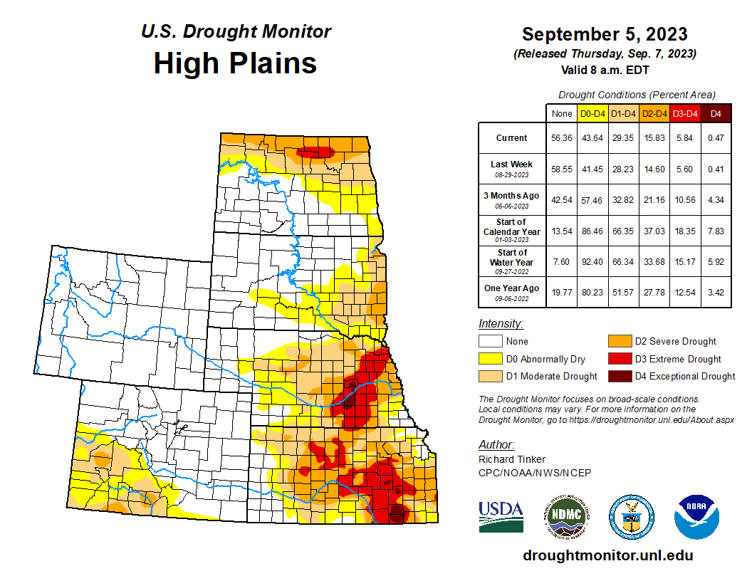
High Plains
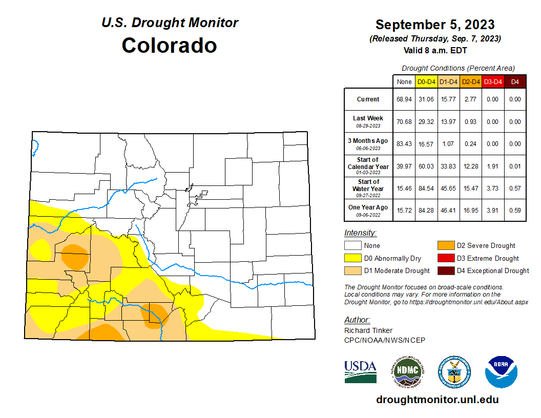
Conditions vary markedly from southeast to northwest here. Similar to western sections of the Midwest Region, Kansas and Nebraska in the southeastern High Plains region are largely covered by drought, including significant expanses of D2 to D3 conditions, with new or expanded D4 (exceptional drought) noted in a few locations. Farther west and north, conditions are much more favorable. To the north and west of central Nebraska, dryness and drought are restricted to the eastern and northern Dakotas, and southwestern Colorado. As in other parts of the Nation’s midsection, agricultural drought stress is palpable, and on the rise. Across Kansas, 40 percent of soybeans are in poor or very poor condition, as are 33 percent of the corn crop, 29 percent of sorghum, and 47 percent of rangelands. Across Nebraska, about one quarter of all the aforementioned crops are in poor or very poor condition. Still, this region did not see the degree of deterioration observed in the Midwest Region, with significant worsening most notable in central and eastern Kansas…

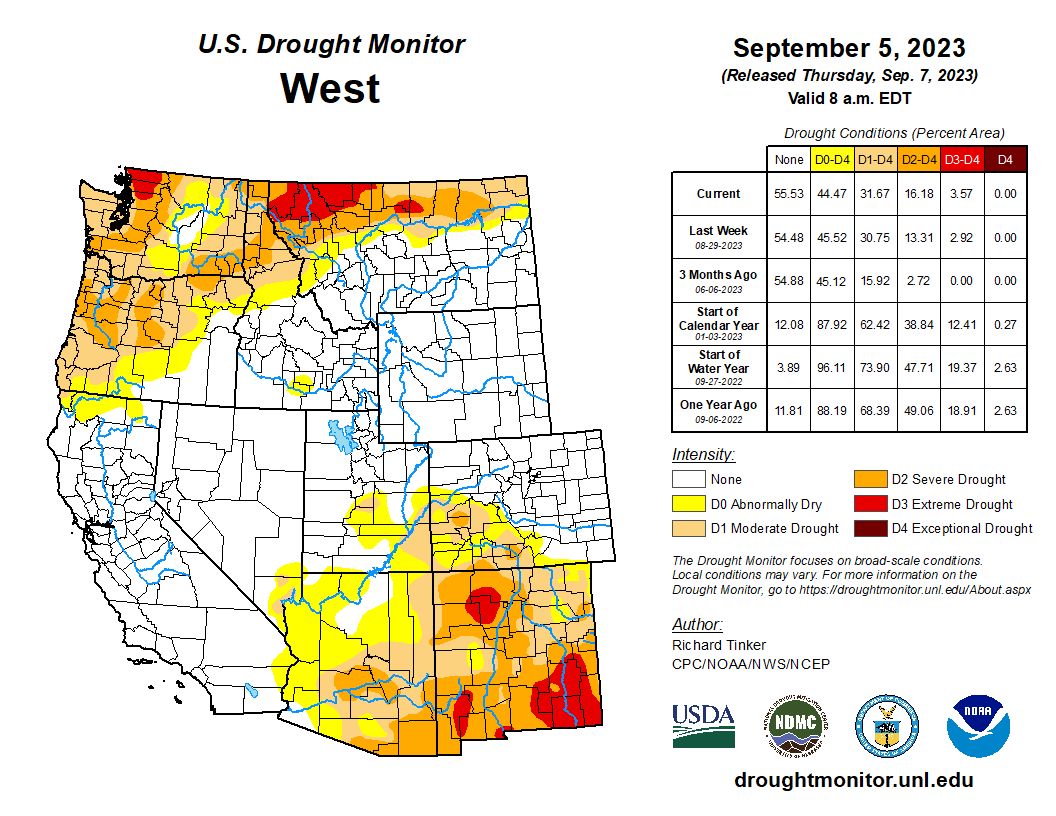
West
Monsoon rains remained subpar across eastern Arizona, New Mexico, and southwestern Colorado, prompting a continued slow deterioration in dryness and drought there. With the monsoonal wet season winding down during September, the odds for heavy precipitation episodes declines, and thus the prospects for significant relief from the intensifying dryness and drought become progressively worse. Dryness and drought also cover large parts of Washington and Oregon as well as the northern tiers of Idaho and Montana. Some deterioration was noted in north-central Montana, but farther west, conditions were essentially unchanged in northern Idaho and the Pacific Northwest…
South
Brutally hot and dry weather again this week kept dryness entrenched across Texas, southern Oklahoma, Louisiana, and southern Mississippi. For the past 2 months, temperatures averaged 4 to 8 deg. F above normal from most of the Four Corners States eastward through most of Texas and Louisiana, and across southern Mississippi. A solid swath of extreme to exceptional drought (D3-D4) is now entrenched from central Texas eastward through most of Louisiana and southern Mississippi, expanding slightly northward as well. Outside the large area of solid D3-D4 conditions, conditions generally deteriorated where dryness was antecedent or on the cusp of developing, and remained essentially unchanged elsewhere. In contrast, Tennessee and most of Arkansas remained free of any systemic dryness. According to the USDA, the cotton crop has not fared well this summer, suffering through the persistent hot and rain-free weather. Almost 80 percent of the Oklahoma cotton crop is in poor or very poor condition, as is 61 percent of Texas cotton. Peanuts, sorghum, soybeans, and rice planted in Texas, Louisiana, southern Oklahoma, and southern Mississippi were also being stressed by from heat and lack of rainfall, although the proportion in poor condition or worse is considerably lower. In addition, deteriorating pastures and rangelands are stressing livestock. As of early September, 72 percent of Texas rangelands, 63 percent of Louisiana pastures, and almost 40 percent of Mississippi pastures were in poor or very poor condition…
Looking Ahead
According to the Weather Prediction Center (WPC), the next 5 days (September 7-11, 2023) will bring some much-needed rainfall to the parched central Plains. Over 0.5 inch is forecast from parts of Oklahoma and the Texas Panhandle northward through Nebraska, with 1.5 to locally 3.0 inches anticipated in part of central Kansas. Moderate to heavy precipitation is also anticipated from the southern Appalachians and adjacent foothills northeastward through the mid-Atlantic and Northeast. At least 1.5 inches is expected from the mountains of northwestern Virginia northeastward through most of the Northeast and New England. The heaviest amounts are expected from central Pennsylvania northeastward through interior southeastern New York, where totals could top 4 inches. Eastern Florida could also receive moderate to locally heavy precipitation, generally 0.5 to locally 2.0 inches. A broad area covering most of the Plains and the Lower Mississippi Valley are expecting several tenths of an inch of precipitation, as are most locations from the Appalachians and eastern Gulf Coast Region eastward to the Atlantic Seaboard. Most other places might see light precipitation, but little or none is expected across the Far West, most of the Rockies, southern Texas, the southern High Plains, the Middle Mississippi and Lower Ohio Valleys, And parts of the interior Deep South. Hot weather is expected to accompany subnormal rainfall totals along the southern tier of the country from southernmost California eastward through the central Gulf Coast Region, as has been the case much of the summer. Daily maximum temperatures are expected to average 5 to 9 deg. F above normal there. In contrast, milder than normal temperatures are expected to displace the heat that has recently affected parts of the Nation’s Midsection, with readings expected to average 3 to 7 deg. F below normal across much of the region from the central High Plains eastward across the Middle Mississippi and Ohio Valleys.
The Climate Prediction Center’s 6-10 day outlook (valid September 12-16, 2023) favors a similar pattern. Odds favor above-normal temperatures from the South Atlantic Region westward across the southern tier of the Contiguous 48 states, over most areas from the Rockies westward, and the northern Plains. Meanwhile, below-normal temperatures are favored across a large swath from the south-central Plains eastward through most of the Mississippi Valley, the Upper Southeast, the Appalachians, the Atlantic Piedmont, the Mid-Atlantic, and the lower Northeast. There are enhanced chances for surplus precipitation across the central and southern Rockies, much of the central and southern Plains, the southern half of the Mississippi Valley, the Ohio Valley, the interior Southeast, the Appalachians, the mid-Atlantic, and the Northeast. In contrast, drier-than-normal weather is favored across most of the Great Lakes, the northern tiers of the Plains and Rockies, the northern Intermountain West, and the Pacific Northwest, as well as across the Florida Peninsula.
Just for grins here’s a slideshow of early September US Drought Monitor maps for the past few years.
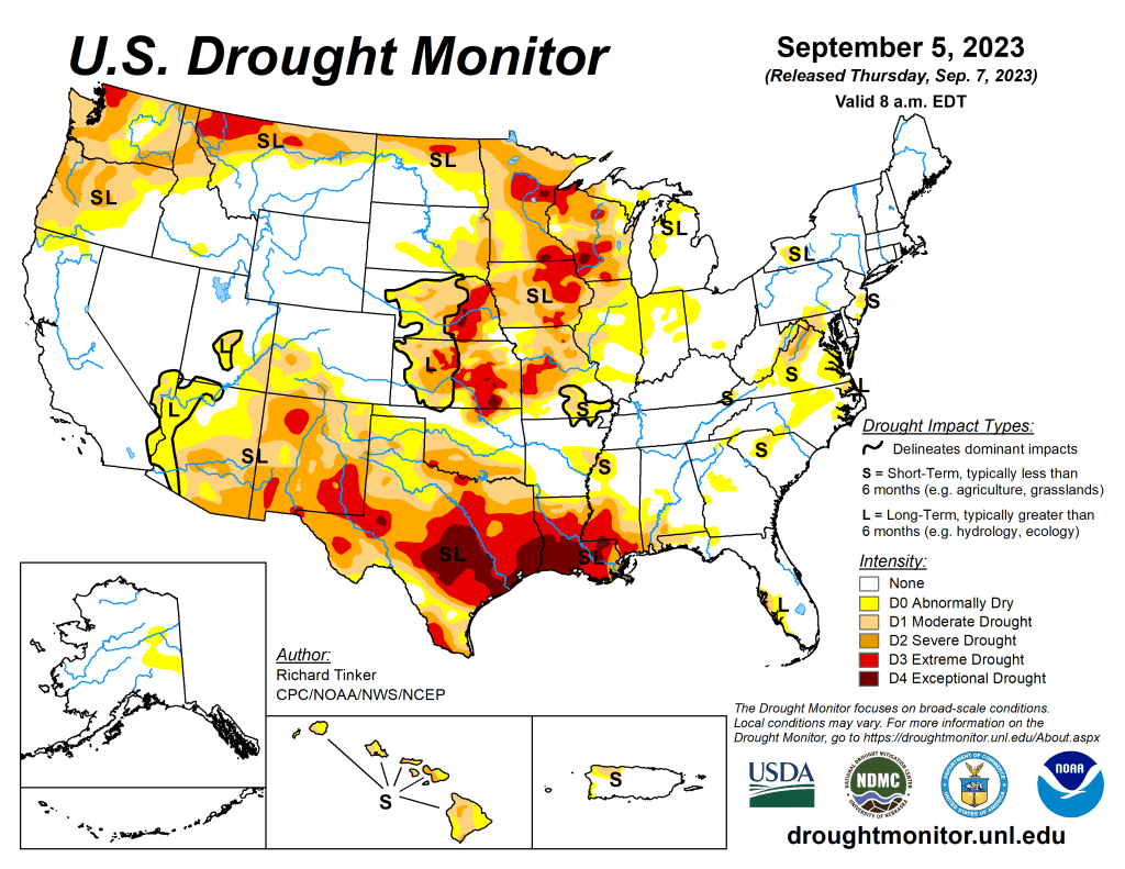
US Drought Monitor map September 5, 2023. 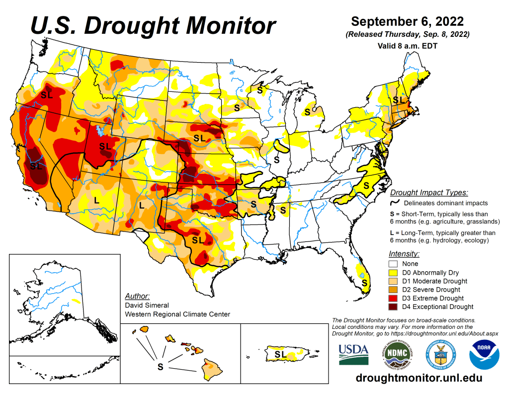
US Drought Monitor map September 6, 2022. 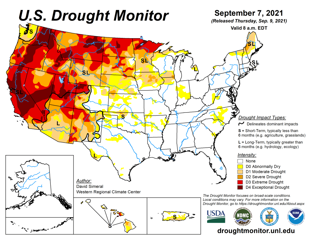
US Drought Monitor map September 7, 2021. 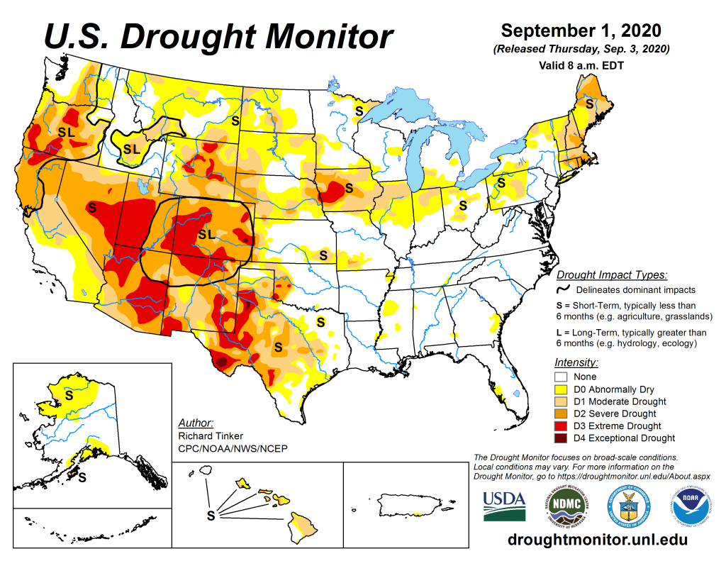
US Drought Monitor September 1, 2020. 
US Drought Monitor September 3, 2019. 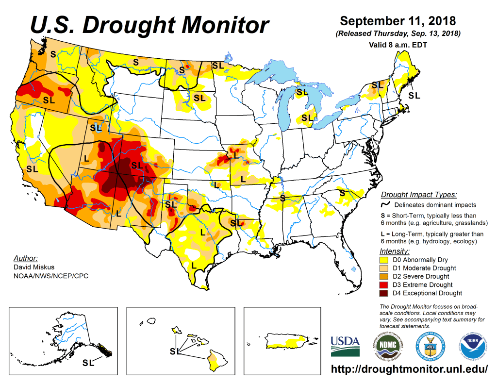
US Drought Monitor September 11, 2018. 
US Drought Monitor September 5, 2017. 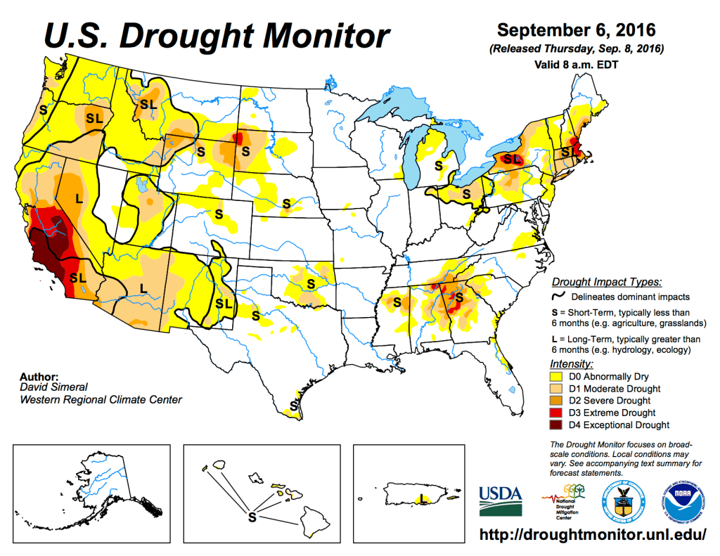
US Drought Monitor September 6, 2016. 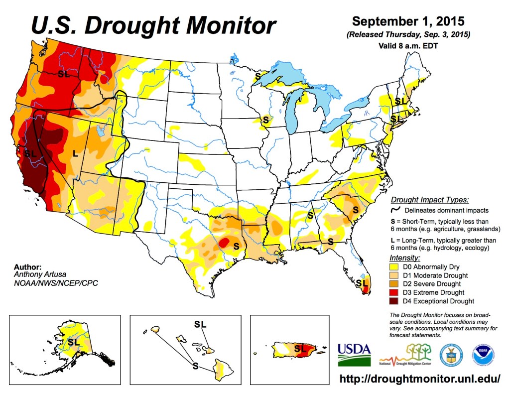
US Drought Monitor September 1, 2015 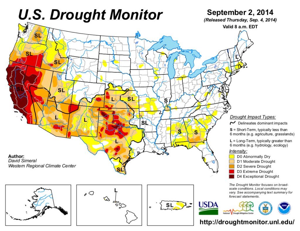
US Drought Monitor September 2, 2014 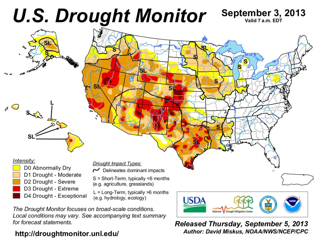
US Drought Monitor map September 3, 2013. 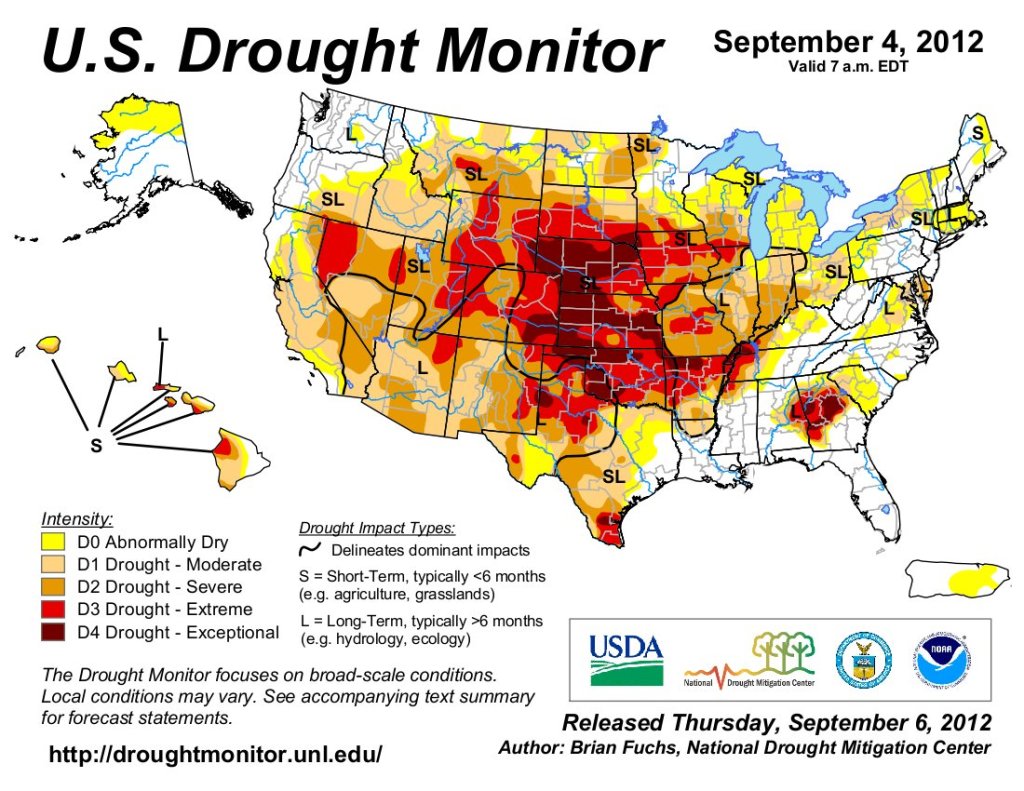
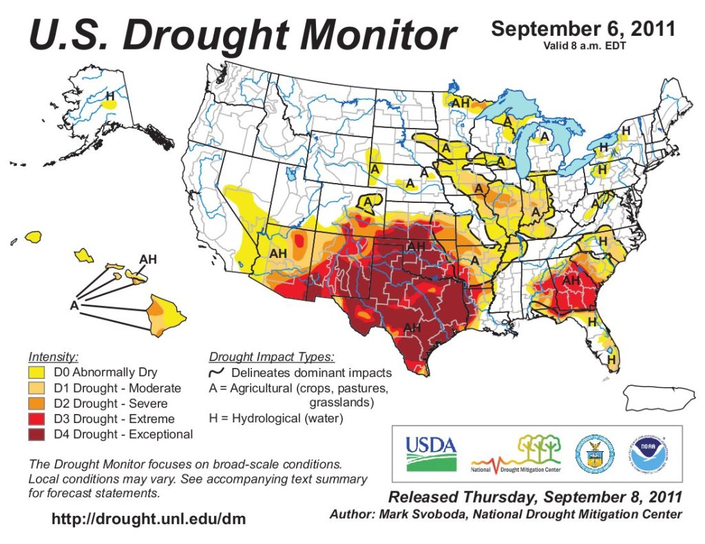
US Drought Monitor map September 6, 2011. 
US Drought Monitor map September 14, 2010.