Denver Water can finish its Gross Dam expansion and fill the controversial reservoir in western Boulder County, the 10th U.S. Circuit Court of Appeals ruled Tuesday, lifting an injunction by a lower court judge and confirming the dam’s permits as sound.
The appeals court said the U.S. Army Corps of Engineers had acted responsibly in issuing construction permits for the $600 million expansion, which is largely complete and will be filled using water rights Denver holds in the Colorado River basin on the western side of the Continental Divide.
“We do not think the Corps’s choice of cost methodology was arbitrary or capricious,” the appeals court ruling said. The plaintiffs, including nonprofit Save the Colorado, argued the Corps rejected clear evidence of climate change, but the appeals court ruled the Corps gave the research fair consideration.
“The Corps considered — and rejected — the reliability of that and similar studies, one of which showed that in the Colorado River Basin, ‘no consistent trends in annual precipitation have been detected over the last 100 years,’” the appeals court said.
“In the end, the environmental groups ask us to substitute our judgment for the Corps’s. They point out scientific studies that, in their view, rebut the Corps’s reading of the scientific literature and ask us to opine on what the scientific research establishes,” the appellate ruling said. “But our job is not to second-guess the Corps’s assessment as long as it rests on a reasoned basis.”
“We’re pleased to see the 10th Circuit Court of Appeals confirm that the Gross Reservoir Expansion Project was lawfully permitted by the U.S. Army Corps of Engineers and that Denver Water can proceed with the final stages of this critical project to ensure a safe, secure water supply for the 1.5 million people we serve,” according to a statement from spokesperson Todd Hartman. “With this decision, Denver Water can move forward with completion of construction, site preparation and eventual filling of the expanded reservoir. An expanded Gross Reservoir is vital to the future of the Denver region.”
It’s nonsensical to be putting more straws in, and further draining, the Colorado River at this point in history,” Wockner said. “That the law allows it to happen doesn’t make it right, it just makes it legal. I saw something wrong, I stood up, spoke out and took action. It was the right thing to do and I would do it all over again.”
Wockner said Tuesday the plaintiffs would not be appealing the decision to the U.S. Supreme Court.
Gross Reservoir Dam backs up South Boulder Creek, while also taking in water through the Moffat Tunnel under the divide, from the Fraser and Williams Fork rivers in the Colorado River basin. Denver Water has said the expansion is needed to balance its water storage system currently heavily concentrated on the southern end of the metro area.
The Trump administration’s Environmental Protection Agency is proposing to further constrain the reach and potency of the Clean Water Act by re-defining what qualifies as “waters of the United States,” or WOTUS, which are streams, wetlands, and other water bodies under federal jurisdiction. The proposed definition would disproportionately affect the arid West by lifting protections from thousands of miles of streams, arroyos, and wetlands.
Under the CWA, a firm or individual looking to discharge pollutants or other material into, or dredge or reroute or otherwise alter, a WOTUS waterway must obtain a federal permit from the EPA or Army Corps of Engineers. A battle has raged for more than five decades over what constitutes a WOTUS. The Supreme Court’s 2023 Sackett v. Environmental Protection Agency ruling called for a narrower definition, handing industry and right-wing ideologues a major victory.
Ephemeral streams are streams that do not always flow. They are above the groundwater reservoir and appear after precipitation in the area. Via Socratic.org
The changes in the latest proposed supplemental rule are even more exclusionary than the administration’s November 2025 proposal, which removed “ephemeral” and “intermittent” waterways — i.e. arroyos or washes that run only after rains or snowmelt — from federal jurisdiction. Included as a WOTUS under that proposal were “relatively permanent … bodies of surface water that are standing or continuously flowing year-round or at least during the wet season.”
The new proposal omits the “wet season” verbiage. It then defines “relatively permanent” to be synonymous with “perennial,” which in turn is defined as ‘‘having standing or continuously flowing water every day of the year during ordinary conditions.’’ However, “a body of water does not lose its relatively permanent status if it dries up as a result of anomalous events such as drought or dry spell.1 A body of water also does not lose its relatively permanent status if it dries up for no more than a single period of up to 30 consecutive days in any given year as a result of non-anomalous events resulting in a temporary interruption such as low tide or a regularly occurring dry spell.” Yet, “if flow is interrupted for two periods in any given year, and each period consists of 10 consecutive days of no flow, the water body would not be jurisdictional.”
A Natural Resources Defense Council analysis found that the new proposal would remove protections from more than 94% of the nation’s wetlands and about 79% of its streams. The changes would hit the West hardest, leaving a state like Arizona with almost no federally protected streams or wetlands.
So here’s my interpretation of where the updated proposal leaves us:
WOTUS waterways (keeps CWA protections): A year-round river, stream, or lake that never dries up, such as the Animas River, the San Juan River, the Colorado River, the Gunnison River, Cement Creek, Mineral Creek, the Fremont River, and so on, would retain federal protections under the CWA. However, since most of these rivers are fed by intermittent or ephemeral streams, they would also be potentially affected (since is someone altered or polluted a tributary, the effects would eventually reach the mainstem).
Non-WOTUS waterways (would lose CWA protections): All intermittent and ephemeral streams, i.e. arroyos or washes that run only when it rains, such as are ubiquitous in the arid West, would be removed from federal jurisdiction. Other streams and rivers that run seasonally, but regularly dry up for more than 30 consecutive days per year, such as the Paria River, the Dirty Devil, Rio Puerco, Santa Cruz River, or the Mancos River, would also lose federal protections, as would wetlands that are only “wet” for part of the year.
Vague WOTUS status: Rivers or streams that are perennial as a whole, but on which certain segments dry up for more than 30 days per year (usually because of upstream diversions), e.g.: the Rio Grande through Albuquerque, long sections of the Lower Dolores River between McPhee Dam and its confluence with the San Miguel, the North Fork of the Gunnison around Paonia, lower reaches of the La Plata River, or Junction Creek through Durango, and numerous desert rivers in Arizona and New Mexico.
While the proposed rule would remove federal CWA protections from many waterways, it would not automatically give developers or industry free rein to bulldoze or dump toxic waste into them. State and local laws would still apply, and arroyos and streams on public land would still be protected to some degree by federal environmental laws. Colorado lawmakers passed a bill in 2024 that effectively backfilled the regulatory gap left by the Sackett decision. New Mexico also has moved to implement its own layer of water protections. In more industry-friendly states such as Idaho and Utah, the proposed rule would leave thousands of miles of streams and waterways vulnerable to development and pollution.
The proposed rule is open to public comments until Oct. 9. You may send comments, identified by Docket ID No. EPA–HQ– OW–2025–0322, by any of the following methods:
Federal eRulemaking Portal: https://www.regulations.gov/. Follow the online instructions for submitting comments.
Email: OW-Docket@epa.gov. Include Docket ID No. EPA–HQ–OW– 2025–0322 in the subject line of the message. •
Mail: U.S. Environmental Protection Agency, EPA Docket Center, Water Docket, Mail Code 28221T, 1200 Pennsylvania Avenue NW, Washington, DC 20460.
Hand Delivery or Courier: EPA Docket Center, WJC West Building, Room 3334, 1301 Constitution Avenue NW, Washington, DC 20004.
For more background on the long and winding struggle to define WOTUS, check out the following:
My February 2022 High Country News piece on the Supreme Court taking up the Sackett Case, including a detailed timeline of the WOTUS definition battle.
And, from the Land Desk archives (you’ll need a paid subscription for access):
A new paper is out from the group of Colorado River experts known by some as the “Traveling Wilburys of the Colorado River Basin,”2 and lo and behold, it actually contains some good news. Namely this: The Lower Basin users have managed to make significant reductions in water use over the last decade and a half without turning the Southwest into a dust-choked wasteland and getting ahead of the latest round of mandated cuts. This indicates that the users can continue to slash water use in the future — to a degree — if necessary.
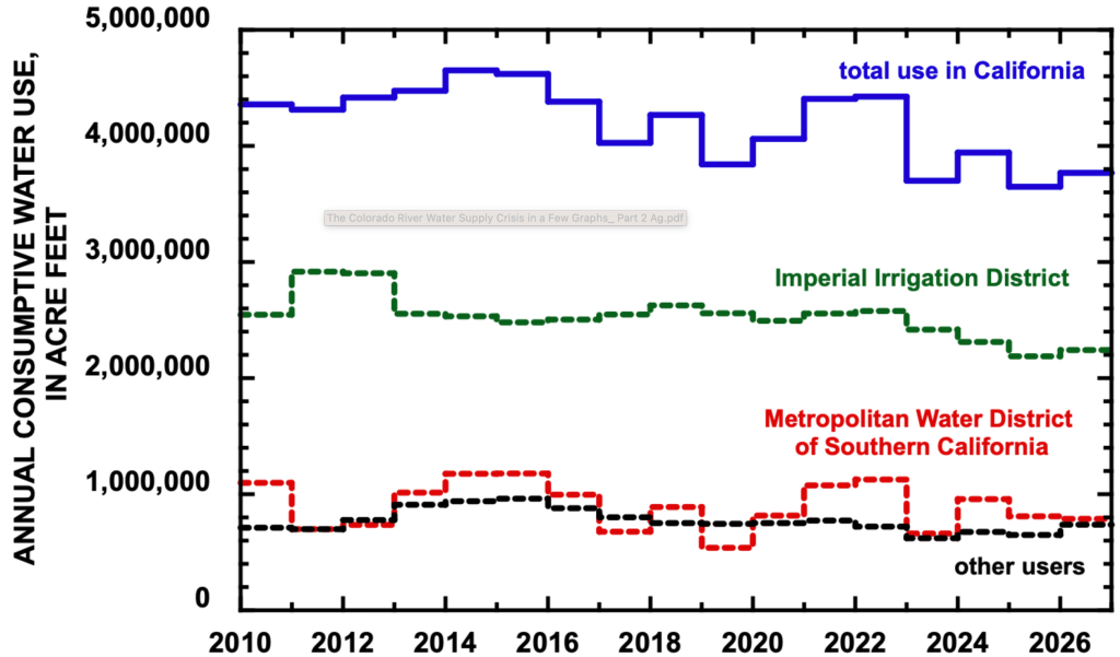
The Lower Basin accounts for about 60% of all consumptive water uses and losses on the Colorado River. Irrigated agriculture, in turn, makes up about 60% of the Lower Basin’s consumptive use. The Imperial Irrigation District, which is primarily agricultural, is the largest single water user on the entire river. This means that the agricultural sector — and the IID in particular — “will play a significant role in future reductions in water use,” as the authors put it.
So far, the Lower Basin’s farmers and the IID have stepped up. In 2025, the Lower Basin states’ consumptive use was 5.76 million acre-feet, the lowest since at least 2010. Since 2023, California has used about 13% less water, a reduction attributable mostly to cuts at IID.
Source: The Colorado River Water Supply Crisis in a Few Graphs: Part 2 Agricultural Water Use in the Lower Basin.
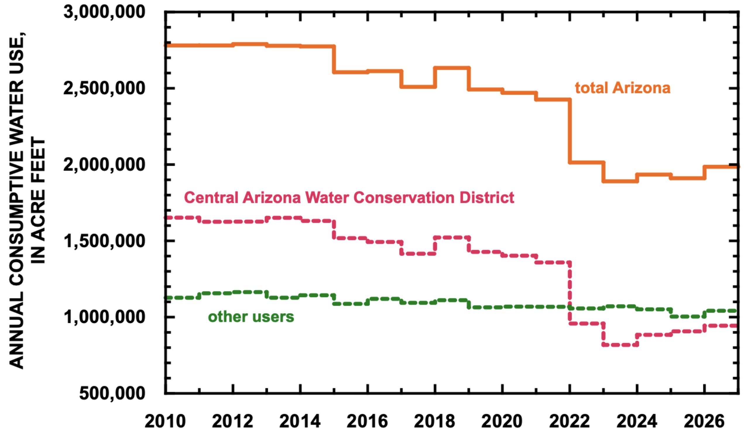
Figure 3. Consumptive use in Arizona since 2010. Estimated use in 2026 based on forecast of September 1, 2026.
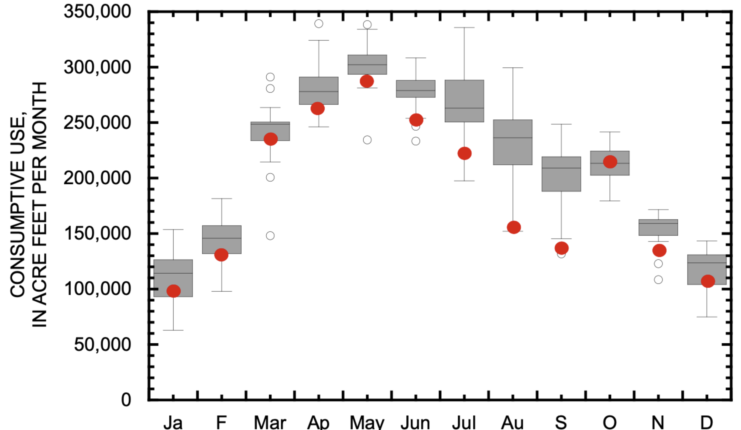
Notably, IID’s reductions came mostly during the summer months, the peak season for field crops such as alfalfa, Bermuda grass, and kleingrass, when it’s too hot to grow most garden crops, such as lettuce, onions, and broccoli. During the vegetables’ growing season, from November through March, water use stayed roughly the same as before. A similar, but less dramatic, dynamic shows up in Arizona.
Figure 6. Box-and-whisker plots of total monthly consumptive use by the IID between 2010 and 2026. Each box is the Inter Quartile Range, defined by the 25th and 75th percentile of the years of data for that month. These boxes represent the typical monthly use pattern since 2010. Red dots are the average use in each month between 2024 and 2026. See text for additional explanation of a box-and-whisker plot.
This suggests a couple of things: 1. The Imperial Irrigation District and other large agricultural users may be able to significantly lower overall water use without harming important garden crops such as broccoli and carrots (easing fears that the Colorado River crisis will deprive us of vegetables); and, 2. The IID is successfully using its vast alfalfa crop as a giant water demand-response tool3. That is, through both fallowing some fields and putting others on a summer water diet, the district’s farmers have managed to slash water use, while still growing gobs of hay and alfalfa.
And because the IID still has about 150,000 acres of alfalfa, it has huge potential for future water cuts through these same methods, which is the good news. The bad news is that the federal plan for operating the river contemplates Lower Basin cuts of up to 3 million acre-feet per year (resulting in a total annual consumption of 4.5 MAF), which is about twice what the Basin has already achieved.
To consider the viability of such cuts, the authors summed up the smallest monthly use in each Lower Basin state since 2010, even though they didn’t occur simultaneously, and even though in some cases the reductions were due to heavy precipitation, not conservation efforts. The result was 5.03 MAF, still 530,000 acre-feet over the potential target. In other words, getting to 4.5 MAF/year is likely to be much more painful than accomplishing the reductions so far.
Yet some pain is likely to be necessary unless the West’s warming climate does a rapid about-face, and soon.
📸 PARTING SHOT 🎞️
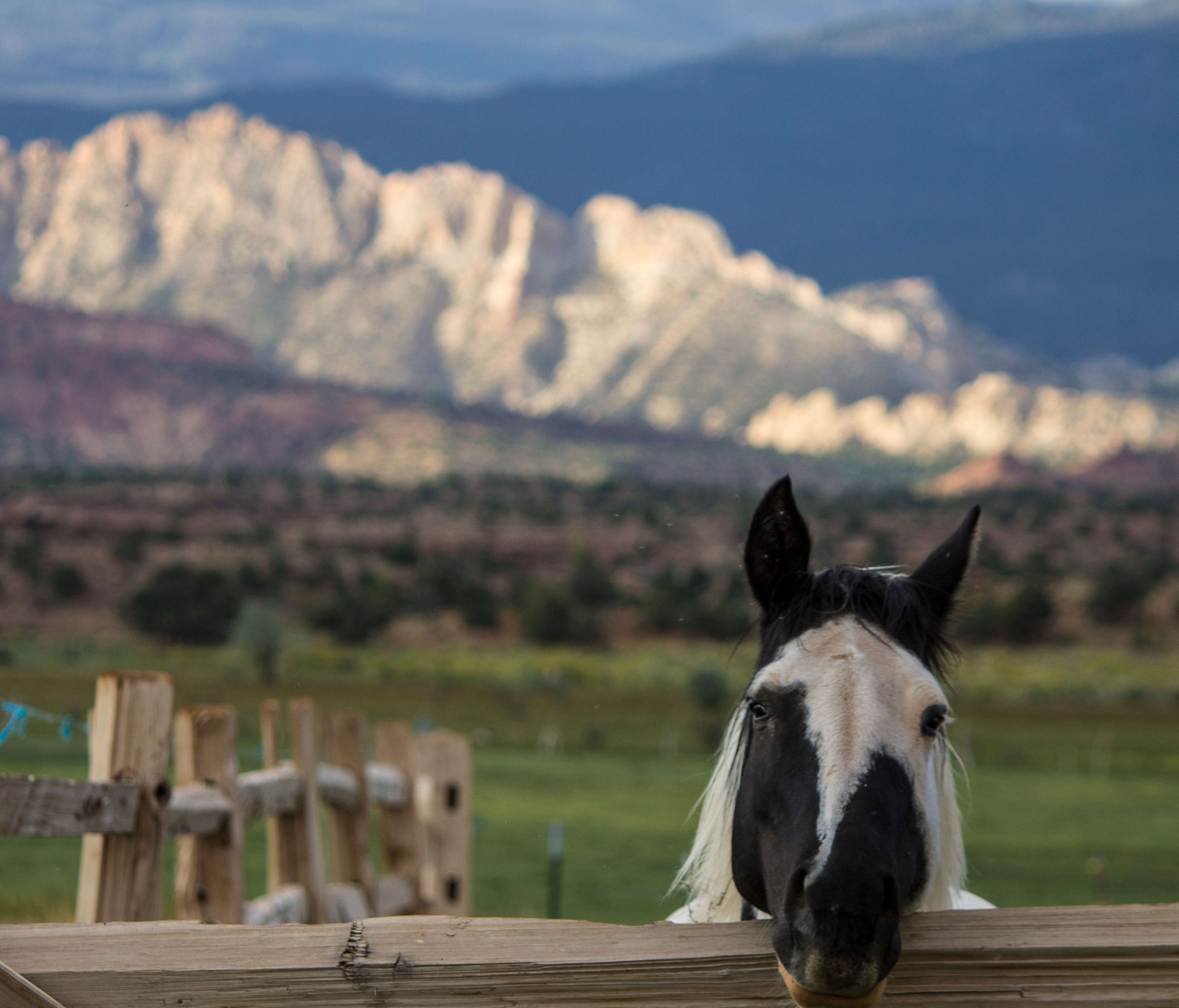
Horse, Torrey, Utah. Jonathan P. Thompson photo.
1 * The proposed rule says “only extreme (D3) and exceptional (D4) droughts would qualify as anomalous drought conditions that can temporarily interrupt perennial flow, and can extend continuously across no more than a five-year timeframe.”
2 This is an appropriate monicker, coined by longtime Colorado journalist Allen Best, and is great for those of us in Generation X or older. But I worry that it might not mean much to anyone under the age of, say, 40? So if you have any more contemporary suggestions for a group of superstar water wonks, aka, Jack Schmidt, Anne Castle, Eric Kuhn, Kathryn Sorensen, and Katherine Tara, I’d love to hear them!
3 Demand response is a term typically used in relation to electricity use. It’s when large power users, or a collection of smaller users, are paid to reduce electricity consumption during times of high demand to ease grid strain. So, for example, during a heat wave, when everyone’s air conditioners are running full blast, the utility or grid operator would signal a factory, say, or a data center, or even a host of smart thermostats, to scale back their operations or dial down the AC during the hottest time of the day when solar generation might be dropping off. The targeted drop in consumption has the same effect as increasing power generation would, keeping supply and demand in balance.
Since Jonathan wonders if anyone under 40 will get the reference to the Traveling Wilburys, here you go: