Click the link to read the article on the Denver Water website (Aidan Lyde):
November 6, 2026
Editor’s note: This story was written by Aidan Lyde, a water planner who focuses on climate at Denver Water.
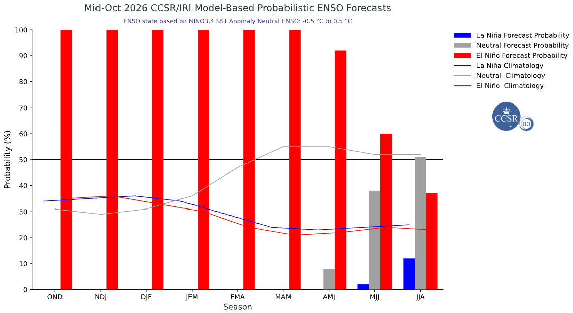
Weather headlines over the last few months have featured a parade of promises about a “super” El Niño, with suggestions that this year’s version of the climate pattern tied to sea surface temperatures in the Pacific Ocean will translate into a snowy winter for Colorado.
But can we be so sure El Niño will save Denver Water or Colorado from the ongoing drought?
The short answer is: We shouldn’t count on it.
El Niño’s influence on Colorado weather patterns is less certain than its impacts elsewhere, and we need to be prepared for a range of potential future outcomes.
An analysis conducted by Denver Water’s Climate Adaptation Program illustrates this uncertainty.
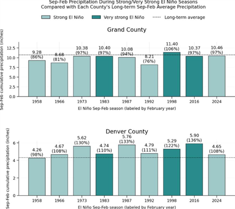
The team looked at the historical record to find years when there was either a strong or very strong El Niño from September through February. Then, they analyzed whether precipitation amounts during those years were wetter or drier than average for Park, Summit, Grand and Denver counties.
The team’s findings?
- None of the three major mountain counties in Denver Water’s collection system (Park, Summit and Grand counties) demonstrated a pattern of being consistently wetter than average.
- In fact, two mountain counties, Summit and Grand, appeared to be consistently drier than average during strong/very strong El Niño years.
- However, Denver County tended to be consistently wetter than average during those periods, with all but one year wetter than average.
How does El Niño impact Colorado?
Colorado has a complicated relationship with El Niño.
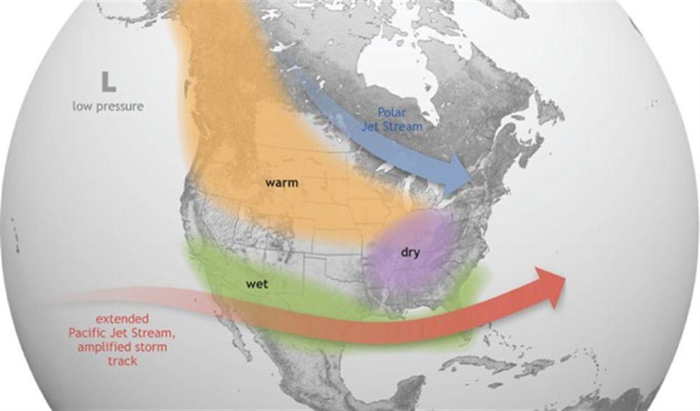
El Niño typically leads to warmer conditions in the Northern U.S., drier conditions in parts of the Midwest and South, and wetter conditions across the southern tier of states.
Colorado sits between many of these expected weather conditions, so we don’t have a clear idea of what to expect.
That said, previous El Niño events have generally resulted in greater precipitation in certain regions of Colorado.
The graphics below show the correlation between seasonal precipitation (winter, spring, summer and fall) and El Niño events in Colorado over the last 75 years, from 1950 to 2025.
The areas in green experienced wetter-than-average conditions during El Niño during the different seasons.
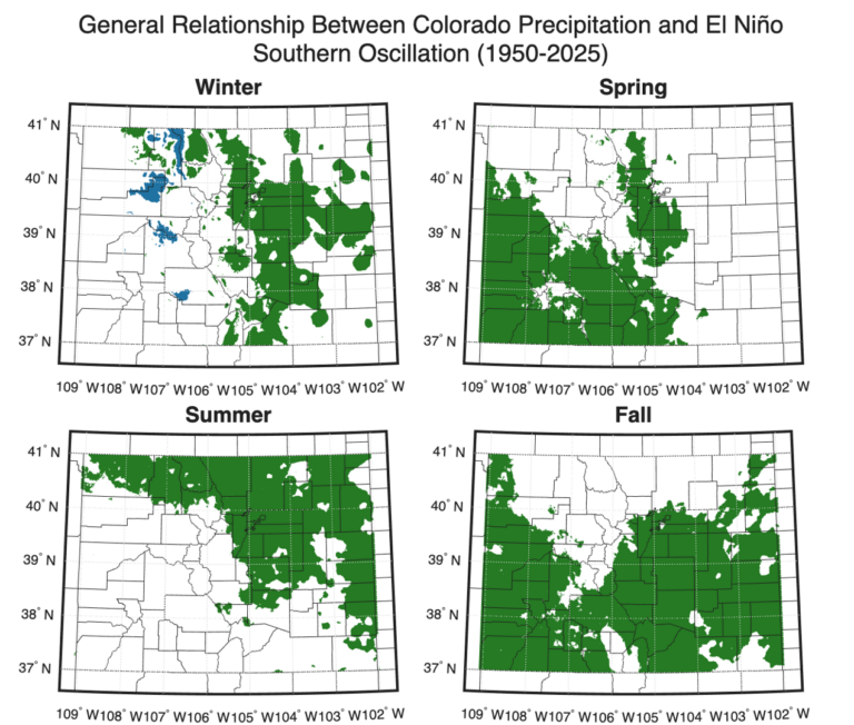
However, as this El Niño event is shaping up to be among the strongest on record, there are no guarantees that this year will continue to follow the seasonal precipitation patterns we have seen in the past throughout Colorado.
The bottom line for Denver Water
We don’t actually know whether Denver Water will receive a boost in water supply or if the dry conditions will continue into next year.
There’s a decent chance that some parts of our collection system will experience wetter conditions, while the signal is mixed for other areas where it could be wetter, drier or average.
We also expect El Niño to raise global temperatures, which could result in less of the precipitation we do receive translating into an available water supply stored in our reservoirs.
The bottom line: Keep hoping for rain and snow, but don’t be surprised if the drought continues.
What is El Niño?
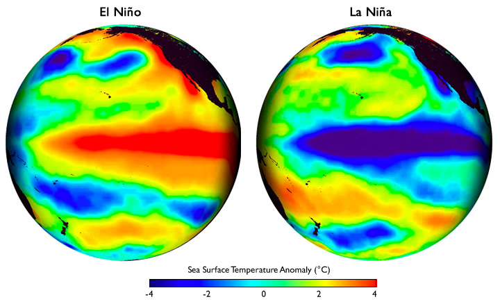
The El Niño-Southern Oscillation (ENSO) is a recurring climate pattern that involves natural changes in sea surface temperatures in the tropical Pacific Ocean.
El Niño is the “warm” phase of ENSO and is characterized by warmer-than-normal ocean temperatures in the tropical Pacific Ocean due to a weakening of the trade winds that blow from east to west along the equator.
La Niña is ENSO’s “cool” phase and is characterized by cooler-than-normal ocean temperatures in this region due to a strengthening of the trade winds.
While it varies, El Niño and La Niña events typically last nine to twelve months and occur every two to seven years.
El Niño and La Niña patterns influence weather patterns around the U.S. and the world due to the influence of sea surface temperatures on atmospheric currents. However, El Niño’s impact on weather varies by region, and those impacts aren’t always as clear as we’d like them to be.
What’s the deal with “super” El Niño?
As it turns out, “super” El Niño is not an official scientific designation despite its common use.
Officially, the term describes what the National Oceanic and Atmospheric Administration, known as NOAA, classifies as a “very strong” El Niño. The strength of an El Niño event is categorized as “weak,” “moderate,” “strong,” or “very strong” based on how much ocean temperatures rise above normal.
The NOAA Climate Prediction Center estimates a greater than 83% chance of a “strong” to “very strong” El Niño through January-March 2027, which could rank among the largest El Niño events in the historical record dating back to 1950.
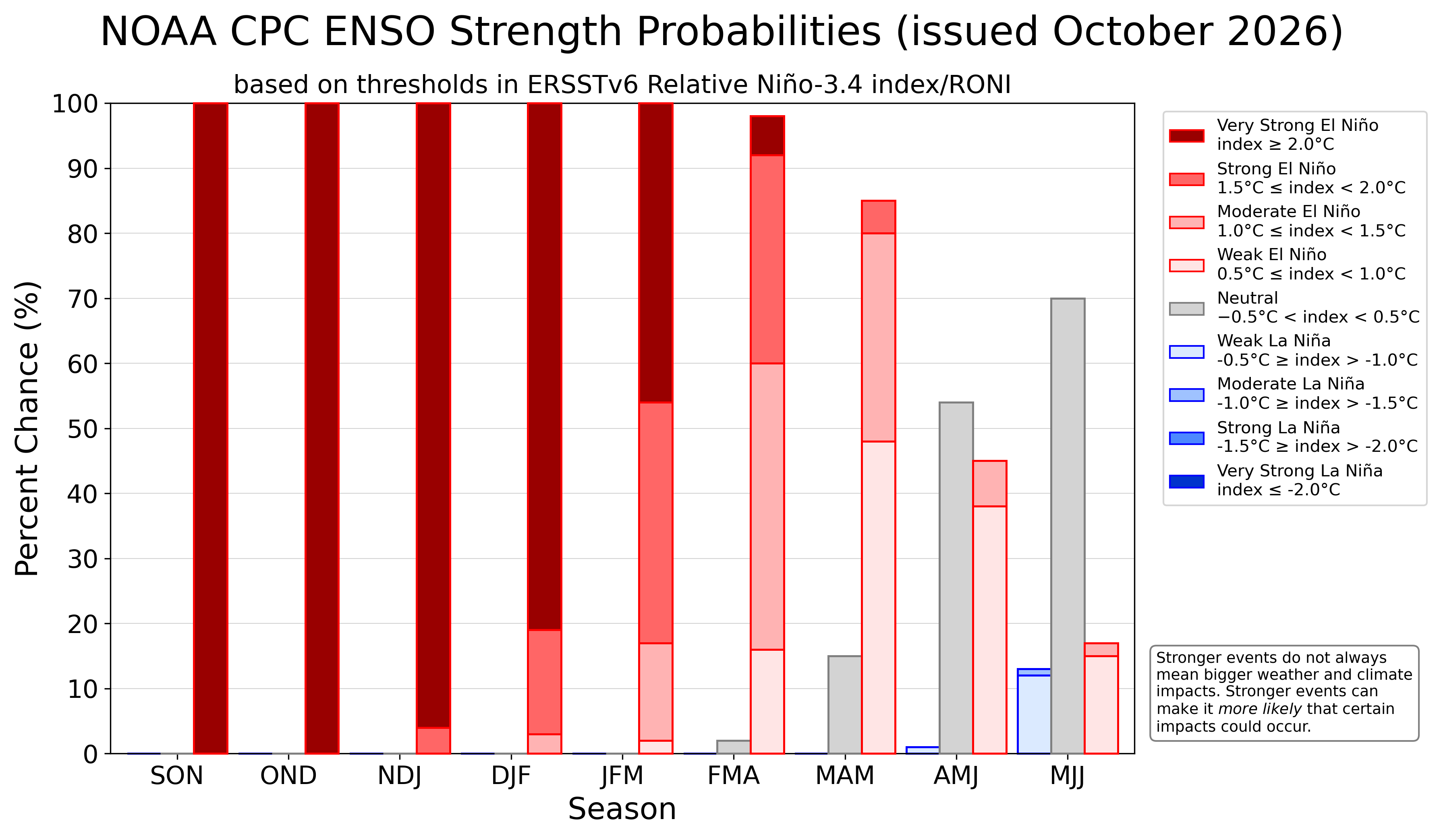
It’s important to note that stronger El Niño events do not always mean bigger weather and climate impacts; instead, they make it more likely that certain impacts could occur (such as heat waves, drought or extreme rainfall).
NOAA forecasts El Niño to strengthen over the fall and winter before weakening through the spring.