The Upper Basin continues to take baby steps toward a formal conserved consumptive program. On Oct. 28, the Upper Colorado River Commission signed a memorandum of understanding with the U.S. Bureau of Reclamation establishing a provisional accounting for water saved through approved Upper Basin conservation projects. The Upper Basin states — Colorado, New Mexico, Utah and Wyoming — want to “get credit” for water they save through programs like System Conservation and potentially others, which they call “qualifying activities.” That water, thus accounted for, could be stored in Upper Basin reservoirs and tapped in the event of a future compact call or other circumstances where it would be needed.
But the MOU is still a dry run until a formal program comes about either in whatever post-2026 reservoir operation framework is adopted or with the establishment of a demand management program.
“The important thing to keep in mind is this provisional accounting exercise is not an operational exercise,” said UCRC attorney Nathan Bracken. “It’s a paper exercise and as a result it will not change the operations of any reservoirs in the upper division states, nor will it provide actual credit itself.”
“New plot using the nClimGrid data, which is a better source than PRISM for long-term trends. Of course, the combined reservoir contents increase from last year, but the increase is less than 2011 and looks puny compared to the ‘hole’ in the reservoirs. The blue Loess lines subtly change. Last year those lines ended pointing downwards. This year they end flat-ish. 2023 temps were still above the 20th century average, although close. Another interesting aspect is that the 20C Mean and 21C Mean lines on the individual plots really don’t change much. Finally, the 2023 Natural Flows are almost exactly equal to 2019. (17.678 maf vs 17.672 maf). For all the hoopla about how this was record-setting year, the fact is that this year was significantly less than 2011 (20.159 maf) and no different than 2019” — Brad Udall
From email from the Community Agriculture Alliance (Sally Cariiveau):
November 5, 2024
The Colorado River Basin is in the midst of a 23-year drought. Reduced precipitation, mostly in the form of snow in the westernmountains, has caused water administrators at the federal, state and local level to seek ways to cut back usage. But many of us in thehigh country do not need water managers to tell us to reduce usage. Mother nature kindly, or unkindly, does that for us.
With limited storage at higher elevations, snowpack is the source for virtually all water on the West Slope.As the Basin experiences asteady decline in precipitation, West Slope water users, especially irrigators, find that in many years, they are subject to “naturalcurtailment.” Less snowpack means less water.
Snowpack is a shared resource in the Mountain West. The water from snowmelt that feeds the West Slope also feeds the Colorado River.The Colorado serves Lake Powell and then Lake Mead, and ultimately consumers in the Lower Basin (Arizona, California and Nevada).
With minor exceptions, all Colorado River water used in those Lower Basin states is stored in the Powell/Mead reservoir system, whichinsulates them from the near-term impact of reduced hydrology upriver from Powell. This system has led to a commonbelief that theUpper Basin states (Colorado, New Mexico, Utah and Wyoming) can mitigate drought-induced problems in the Lower Basin simply bysending more water downstream.
Unfortunately, data indicates that during times of hydrological shortfall, the Upper Basin is already naturally experiencing reductions.Recent history provides a high-level example. In the five years from 2016 to 2020, usage averaged 4.6 million acre-feet in the UpperBasin. In 2021, a low-precipitation year, that figure fell to 3.5 MAF, clearly demonstrating the natural curtailment effect.
During the 2016 to 2020 period, Lower Basin usage averaged 10.7 MAF, an amount which actually climbed to over 11.0 MAF in 2021.As abenchmark, the 1922 Colorado River Compact optimistically allocates 7.5 MAF to each basin.
Yampa River Basin via Wikimedia.
In dry years, natural curtailment impacts nearly everyone on the West Slope. Ranchers on tributary creeks often have to choose whichheadgates and ditches to operate.Even irrigators on the mainstem of the Elk and Yampa have years when, in late summer, they arerequired to use far less than their adjudicated rights.
Fishing, rafting/tubing and other recreational uses on the Yampa are often restricted, while water districts experience cutbacks duringlate-season low flows.
Meanwhile, solutions to Colorado River shortages have been elusive, and discussions difficult to facilitate. Politics and public messaginghave played a major role; Lower Basin organizations have used every major media outlet to build public sympathy for their argument thatthey should not be the only ones to “sacrifice.”
Natural curtailment in the Upper Basin has been, until very recently, far outside of public perception. But it exists, and water users andorganizations of the Lower Basin must acknowledge and understand it as a key component of future operating agreements.
We in the Upper Basin need to make natural curtailment a part of our story. Raising public awareness of this elemental fact can help usto defend our rights in the Colorado River.
Lake Powell has been about a quarter-full. The snowpack looks strong now, but it’s anybody’s guess whether there will be enough runoff come April and May to substantially augment the reservoir. May 2022 photo/Allen Best
Click the link to read the article on the Big Pivots website (Allen Best):
October 24, 2024
Colorado River Basin states have scaled back their demands on the river. But agreement about solutions proportionate to the challenge remains distant as the 2025 deadline nears.
The story so far: Andy Mueller, the manager of the Colorado River District, the lead water policy body for 15 counties on the Western Slope of Colorado, used his organization’s annual seminar this year to call for the state to begin planning for potential curtailments of diversions. The river has delivered far less water in the 21st century than was assumed by delegates of the seven basin states when they drew up the Colorado River Compact in 1922. Might higher flows resume? Very unlikely, given what we know about climate change. See Part Iof the series and Part II.
“Having a state plan for compact curtailment has been on the table for what seems like forever, likely 2005 to 2007,” said Ken Neubecker. Now semi-retired, he has been carefully watching Colorado River affairs for several decades and has represented several organizations at different times.
Why hasn’t Colorado moved forward with this planning? When I called him to glean his insights, Neubecker shared that he believes it’s because such planning encounters a legal and political minefield.
“It’s not as simple as pre-1922 rights are protected and post-1922 rights are going to be subject to curtailment based on the existing prior appropriation system.”
Denver Water’s Moffat Tunnel diversion from the Fraser River to Boulder Creek. Most of water diverted to Colorado’s Front Range cities from Western Slope rivers and creeks have legal rights junior to the Colorado River compact. Photo/Allen Best
Front Range municipal water providers and many of Colorado’s agriculture diversions are post-1922 compact. And so are some agricultural rights on the Western Slope.
“I think everybody thinks that well, we’re on the slow-moving train and the cliff is getting closer but it’s not close enough – and there are other things that we can do to slow the train down.”
Taylor Hawes, Colorado River Program director for the Nature Conservancy via Water Education Colorado.
Taylor Hawes, who has been monitoring Colorado River affairs for 27 years, now on behalf of The Nature Conservancy, suspects that Colorado doesn’t want to show its legal hand or even admit the potential need to curtail water use in Colorado. She contends that planning will ultimately provide far more value.
“The first rule you learn in working with water is that users want certainty. Planning is something we do in every aspect of our lives, and planning is typically considered smart. It need not be scary,” she told Big Pivots. “We have all learned to plan for the worst and hope for the best.”
Colorado can start by creating a task force or some other extension of the state engineer’s office to begin exploring the mechanisms and pathways that will deliver the certainty.
“We don’t have to have all the answers now,” Hawes said. “And just because you start the process for exploring the mechanism to administer compact compliance rules doesn’t mean you implement them. It will give people an understanding of what to expect, how the state is thinking about it.”
Rio Grande near Monte Vista. Meeting Colorado’s commitments that are specified in the compact governing the Rio Grande requires constant juggling of diversions. Photo/Allen Best
Compacts have forced Colorado to curtail diversions in three other river basins: the Arkansas, Republican and Rio Grande. The Rio Grande offers a graphic example of curtailment of water use as necessary to meet compact obligations on a week-by-week basis.
The Republican River case is a more drawn-out process with a longer timeline and a 2030 deadline. In both places, farmers are being paid to remove their land from irrigation. The Colorado General Assembly this year awarded $30 million each to the two basins to bolster funding for compensation.
A study commissioned by the Nature Conservancy that involved interviews with water managers and others in those river basins had this takeaway message: “the longer (that) actions are delayed to address compact compliance, the less ability local water users have to tailor compliance-related measures to local conditions and needs and reduce their adverse impacts.”
In the Arkansas Basin, Colorado had to pay $30 million and water available to irrigators was reduced by one third.
“That’s the first lesson in how not to do compact compliance: do not wait to be sued because (then you lose) the flexibility to do stuff the right way,” said one unidentified water manager along the Arkansas River.
Neubecker points to another basin, the South Platte. Even in 1967, Colorado legislation recognized a connection between water drawn from wells along the river and flows within the river. The 2002 drought forced the issue, causing Hal Simpson, then the state engineer, to curtail well pumping, creating much anguish.
Ken Neubecker via LinkedIn
Creating a curtailment plan won’t be easy, Neubecker warns. “It could easily take 10 years. ’Look how long it took to create the Colorado Water Plan. It took a couple years and then we had an update five years later. And that was easy compared to this.”
All available evidence suggests the Colorado River Basin states are nowhere near agreement.
In August, Tom Wilmoth provided a perspective from Arizona in a guest opinion published by The Hill under the title of “Time is running out to solve the Colorado River crisis.” As an attorney he has worked for both the Arizona water agency and the Bureau of Reclamation before helping form a law firm in 2008.
“It has taken 24 years for the problem to crystalize, but less than 24 months remain to develop a solution,” he wrote. “Yet there appears to be little urgency in today’s discussion among the Colorado River Basin’s key players.”
Wilmoth said ”Deferring hard conversations today increases the risk of litigation later.” He, like all others, sees a reasonable chance it would end up before the Supreme Court – with the risk of the justices appointing a special master to adjudicate the conflict. “Its recent tendency has been to appoint individuals lacking in subject matter expertise, a troubling prospect given the complex issues at play.”
The area around Yuma, Ariz., and California’s Imperial Valley provide roughly 95% of the vegetables available at grocery stores in the United States during winter months. February 2017 photo/Allen Best
Monitoring the conversations from Southwest Colorado, Rod Proffitt sees Mueller trying to prepare people in the River District for the challenges ahead.
“I think he has tried to scare people. He is trying to get them prepared to make some sacrifices, and limiting growth is a sacrifice.”
A semi-retired water attorney, Proffitt is also a director of Big Pivots, a 501-c-3 non-profit.
Make no mistake, says Proffitt, more cuts in use must be made – and they need to be shared, both in the lower basin and in the upper basin. What those cuts need to be, he isn’t sure. Nor do they necessarily need to be the same.
For example, he can imagine cuts that are triggered by lowering reservoir levels. At a certain point, lower basins must reduce their use by X amount and upper basin states by Y amount.
The federal government has mostly offered carrots to the states to reduce consumption, a recognition of the river’s average 12.4 million acre-feet flows, far short of the flows assumed by the compact. It also has sticks, particularly regarding lower-basin use, but has mostly avoided using its authority. Instead, the lower-basin has reduced use voluntarily, if aided by the federal subsidies.
The Inflation Reduction Act and the Bipartisan Infrastructure Act, have yielded a river of money for projects in the West that broadly seek to improve resiliency in the face of drought and climate change. The seeds have been planted in many places. For example, a recent round of funding produced up to $233 million for the Gila River Indian Community in Arizona for water conservation efforts.
The federal government has also offered incentives to reduce consumption in the upper basin. The System Conservation Pilot Program ran from 2015 to 2018. The 2024 program was funded with $30 million through the Inflation Reduction Act and had hopes for conserving about 66,400 acre-feet.
The federal government, through the Bureau of Reclamation, has clear authority to declared water shortages in the lower basin. It has warned that three million acre-feet less water must be used. The lower-basin argues that the upper basin should share in some of this burden.
Grand Junction has a maze of irrigation canals but the municipal water utility gets water from a creek that flows from the Grand Mesa. Some diversions in Colordo are pre-compact, but many others occurred after 1922. This is a scene from Grand Junction. Photo/Allen Best
Should the federal government get out the stick?
“Nobody wants to apply vinegar this close to the November election,” said James Eklund when we talked in late September about the stalemate on the river.
Eklund has had a long association with the Colorado River. His own family homesteaded on the Western Slope near Colbran in the 1880s and the ranch is still in the family. He lives in Denver, though, and was an assistant attorney in the state attorney general’s office in 2009, when I wrote my first story. He later directed the Colorado Water Conservation Board, the lead agency for state policy.
For the last few years Eklund has been on his own, more or less, a water attorney now working for Sherman and Howard, a leading Denver firm, while trying to represent clients with diverse agriculture water rights.
“Litigation is a failure,” he said when I asked him about Mueller’s remarks in Grand Junction. He contends the upper basin must come to the table with more ideas about how to solve the structural imbalance between supplies and demands than it has so far. And this, he said, will involves some pain.
Creating compact curtailment will involve rule-making, though, and that will take time and effort. Echoing Denver Water’s position, he says it will divert Colorado from the more important and immediate work of helping negotiate solutions.
Eklund suspects an ulterior motive of the River District: to get the state to play its cards on what curtailment could look like so that it can begin jockeying for position.
On the other hand, he believes cutbacks should be premised on two bedrock principles: voluntary and compensated. But Eklund also says that if the situation becomes desperate enough, water will continue to find its way to cities. “The Front Range is not going to bend its knee to alfalfa plants. It’s not going to do it.”
And then, Colorado’s Constitution allows municipalities to take water. It requires compensation.
The Bureau of Reclamation has said the same thing in the lower basin. Las Vegas and other cities will not be allowed to dry up.
The Bureau of Reclamation has said that Las Vegas and other cities will not be cut off from water in the Colordo River. . Photo/Allen Best
But what if compact curtailment means making the hard decision about who doesn’t get water and does not get compensated – people like the farmers near Fort Morgan who, in 2002, had to cease pumping water?
Neubecker characterizes the position of Colorado as one of conflict avoidance. Look at where it got Neville Chamberlain, the British prime minster, in his negotiations with Hitler.
What Colorado must do is prepare for the worst-case scenario. “It’s a doomsday plan,” Neubecker says of compact curtailment. “Make the plan, involve all the people who are going to be effected by the plan, and put it on the shelf – but not too far back on the shelf, just in case you need it”
For now, water levels in the two big reservoirs are holding more or less steady.
Another winter like 2002 could trigger renewed clanging of alarm bells.
John Fleck at Morelos Dam, at start of pulse flow, used 4/4/14 as my new twitter avatar
In New Mexico, Fleck, the author, who also monitors Colorado River matters at his Inkstain blog, rejects the metaphor of the Titanic or the idea that conflict is inevitable. In 2002, California was still using 5.1 million acre-feet from the Colorado River, both for agriculture and to supply the metropolitan areas of Southern California. This was well above the state’s apportionment of 4.4 million acre-feet. “The rhetoric was that it will be a disaster to California’s economy” to return to the allocated flows.
California eventually did cut back and it has done just fine. “Everybody would prefer not to do the adaptation, but they have done it just fine. We see that over and over again in community responses to drought in the Western United States,” he said.
Lake Powell currently has filled to 40% of capacity, a marked improvement from February 2023, when the reservoir had fallen to 22% of capacity. Mead is at 36% of capacity. The situation is not as tense as it was two years ago. That could change in the blink of another hot, dry runoff like that in 2002.
Figure 2. Graph showing reservoir storage between 1 January 2023 and 15 October 2024, highlighting the amount of reservoir recovery during each snowmelt season and the amount of reservoir drawdown during intervening periods. Credit: Jack Schmidt/Center for Colorado River Studies
Roaring Fork River September 2022. Photo credit: Allen Best
Click the link to read the article on the Big Pivots website (Allen Best):
October 22, 2024
Our story so far: Andy Mueller used the Colroado River District seminar this year to call for Colorado to begin planning for potential curtailment of the Colorado River. The state engineer, who is legally responsible for such planning, it it occurs, pushed back, saying first things first. For Part I, go here.
Andy Mueller, general manager of the Colorado River District, has used the district’s annual seminar in Grand Junction in years past to warn of a worsening situation in the Colorado River Basin. Two years ago, for example, he warned that flows were already well below the 20th century averages. Might those flows of 13.5 to 14 million acre feet further decline to 9.5 million acre-feet in decades ahead?
Even relatively healthy snowfalls don’t necessarily produce robust volumes of runoff. For example, snow during the winter of 2023-24 was good but runoff just 84% of average.
“A new different” is how Dave Kanzer, the River District’s director for science and interstate matters, described the runoff numbers. [ed. emphasis mine]
“We are just kind of treading water, and where we are next year could be similar to where we are this year — unless something changes,” he added during the district’s seminar in Grand Junction. “There’s a lot of uncertainty.”
Warming temperatures most likely will produce continued declines in river flows. That was a key takeaway of the presentation by Russ Schumacher, the state climatologist. He’s a careful scientist, clear to differentiate what is known from that which is not. Much of what he said was not particularly new. Some of the conclusions he offered were little changed from those of a decade ago – but with one key difference. Another decade of data has been compiled to support those conclusions.
Seven of Colorado’s nine warmest years have occurred since 2012. The rise can be seen most clearly in summer and fall records. This past summer was part of that trend. It was the sixth hottest summer in Colorado’s recorded history going back to the late 1800s.
Some places were hotter than others, though. In Grand Junction, gages at Walker Airfield recorded the hottest June-August period ever, an average of more than 80 degrees. That’s the average temperature 24/7, day and night.
Precipitation? No clear trend has emerged. Levels vary greatly from year to year.
Graphic credit: Russ Schumacher/Colorado Climate Center
Integration of temperature and precipitation records tell a more complex and concerning story. Rising temperatures have produced earlier runoff. The warmth also exacerbates evapotranspiration, which is also called evaporative demand. The warmer it is, the more surface air draws water from the plants and dries out the soils.
The most powerful way of explaining all this was in two sequences of slides, one of which is reproduced here.
“The timing shift, even if the peak doesn’t change all that much – the timing is quite important,” said Schumacher. Colorado River flows at Dotsero, near Glenwood Canyon, have already declined 25% during late summer.
Schumacher and other scientists describe predictions with various degrees of confidence. There is, he said, high confidence of a future warming atmosphere that to an even greater degree reduces runoff no matter how much snow falls in winter. We can be sure of temperatures rising between one and four degrees F by mid-century, he said.
Unless Colorado gets far more snow and rain, the ColoradoRiver will decline further. [ed. emphasis mine]
Future warming depends upon how rapidly greenhouse gas emissions rise globally. In mid-October, they were at 418 parts per million high on the slopes of Hawaii’s Mauna Loa. They were 315 when the first measurements were taken there in 1958 and roughly 280 at the start of the industrial era.
Graphic credit: Russ Schumacher/Colorado Climate Center
And that returns us to the Colorado River Compact, the foundation for deciding who gets what and where in the basin — and who doesn’t.
In 1922, when the Colorado River Compact was drawn up at a lodge near Santa Fe, the Colorado River had been producing uncommonly robust flows. In their 2019 book, “Science Be Dammed,” Fleck and Eric Kuhn, the former general manager of the River District, explained that ample evidence even in 1922 existed of drier times just decades before. Later evidence documented lesser flows in the centuries and millennia before.
Not only were flows in the Colorado River during the 20th century much less than was assumed by the compact, the document failed altogether to acknowledge water rights for Ute, Navajo and 28 other Native America tribes in the basin who were to get water as would be necessary to sustain agricultural ways of life. Just how much had not been determined, although it’s now estimated at 20% of the river’s total flow. Some claims still have not been adjudicated.
Mueller called it a “flawed document” produced by a “flawed process” that had “faulty hydrological assumptions” and did not include “major groups of people who reside in and own water rights in this basin.”
A March 31, 1922 photo of the Colorado River Commission. Standing left to right: Delph E. Carpenter (Colorado), James G. Scrugham (Nevada), R. E. Caldwell (Utah), Frank C. Emerson (Wyoming), Stephen B. Davis, Jr. (New Mexico), W. F. McClure (California) and W. S. Norviel (Arizona). Seated: Gov. Emmet D. Boyle (Nevada), Gov. Oliver H. Shoup (Colorado), Herbert Hoover (federal representative and chair) and Gov. Merritt C. Mecham (New Mexico). The governors were not members of the Commission. Photo: Colorado State University Library
For its time, though, the compact was a grand bargain. Colorado’s Delph Carpenter was a key negotiator. He had realized that if diversions from the Colorado River were determined by the doctrine of prior appropriation, the bedrock for water law in Colorado and most other states, the upper-basin states would lose out because they would develop the Colorado River more slowly. Instead, the compact created an equitable apportionment, essentially a 50-50 split of the water between upper and lower-basin states.
It was the foundation for what is now called the Law of the River, by which is meant the many laws, court decrees and agreements concerning both surpluses and droughts.
Dams were built, diversion structures constructed – including, because of a law of Congress in 1968, the Central Arizona Project (which also resulted in dams on the Animas and Dolores rivers in Western Colorado). That 1968 legislation, the Colorado River Basin Project Act, recognized that the river would be short by as much as two million acre-feet, said Mueller.
And then the agreements of the 21st century have tried to acknowledge lesser flows. But they have also deferred the really hard questions. The harder questions, as Mueller suggested, may yet provoke the states to get out their legal swords.
Central to the dispute is how much water should the upper basin states be releasing from Lake Powell? This is the key clause in the compact: “The States of the Upper Division will not cause the flow of the river at Lee Ferry to be depleted below an aggregate of 75,000,000 acre-feet for any period of ten consecutive years …”
Lee Ferry, located in Arizona but a few miles downstream from Glen Canyon Dam, is the formal dividing point between the upper-basin states and lower-basin states in the Colorado River. It is also the put-in location for boaters rafting or kayaking the Grand Canyon. Photo/Allen Best
Flows from Colorado and other upper-division states have been about 86 million acre-feet over the last 10 years.
Lower-basin states say no, that’s not enough. They argue that the upper basin states need to accept cuts, too.
For now, there is no dispute that the upper basin states are meeting that obligation. But what if a string of years like those of 2002-2004 return? And what if the case ends up before the Supreme Court and that court ultimately rules against the upper basin?
This sets up the potential – Mueller characterized it as a certainty – for conflict, a court case that will have to go before the U.S. Supreme Court.
“I don’t believe we’re violating the compact today, and I don’t think we’re going to be violating the compact necessarily if the river drops, if our delivery below Glen Canyon drops,” he said. “What I can tell you is we’re going to have litigation.”
In May 2022, a couple paused at once had been the bottom of the boat put-in ramp in Antelope Canyon to lok down on the receding waters of Lake Powell. The reservoir at that point was 22% full. Photo/Allen Best
Colorado, Mueller asserted, must put together rules for how it will handle shortages if the state must curtail it diversions in order to allow water to flow downstream. He called it a painful process but warned that the “future is not far away.”
The River District position is that the burden within Colorado cannot fall entirely on the Western Slope and its ag users. Programs designed to reduce compensation have been focused solely on the Western Slope and agriculture, says Lindsay DeFrates, deputy director of public relations.
“If we are looking to reduce water long term, we can’t put it on the backs of West Slope users,” she says. “It has to be a shared burden.”
Journalists insist that it’s Western Slope. People in the water community invariably say “West Slope.”
Next: Colorado River Basin states have scaled back their demands on the river. But But agreement about solutions proportionate to the challenge remain distant as deadline near.
Colorado transmountain diversions via the State Engineer’s office
Unfortunately, water use between now and next April is on track to exceed the inflows of the snowmelt season, resulting in a net loss of reservoir storage. The persistent decrease in runoff is severely challenging the quest to rebuild reservoir storage.
Summary
Reservoir storage in the Colorado River basin is now approximately equal to two year’s average annual consumptive use. In the three months since reservoir storage peaked in July 2024, drawdown of those reservoirs lost more than 80% of the increase accomplished by the 2024 snowmelt inflow season, which had increased basin reservoir storage by only 2.5 million acre feet despite the Upper Basin snowpack having peaked at a snow water equivalent that was 13.5% greater than the long-term average1. If this rate-of-use continues for the next six months, there will be a net loss in basin reservoir storage. Water supply reliability and security for Colorado River water users can only be accomplished if we replenish the amount of water stored in reservoirs and not further deplete the declining supply.
Details
On 15 October 2024, total contents of the reservoirs of the Colorado River Basin upstream from the Gila River were 27.8 million af (acre feet). This amount of reservoir storage would support two years of consumptive use of the Colorado River2, assuming that basin consumptive uses remain approximately 13 million af/yr, the average between 2021 and 2023. Reservoir storage today is comparable to conditions in mid-June 2021 (Fig. 1) when there was increasing concern among the basin’s water managers about the security and reliability of water supplies provided by the Colorado River. Today, we should be just as concerned as we were in 2021.
Figure 1. Graph showing total basin reservoir storage (blue line), and storage in different parts of the Colorado River watershed between 1 January 2021 and 15 October 2024. CRSP reservoirs are those authorized by the Colorado River Storage Project Act. Credit: Jack Schmidt/Center for Colorado River Studies
The only way to increase the security and reliability of the water supply is to increase reservoir storage, and we are not doing a very good job of achieving that goal. There is no doubt that the large reservoir inflows of 2023 benefitted the basin water supply, allowing us to take a step back from the edge of the cliff of crisis. Basin reservoirs in mid-March 2023 were the lowest they had been (21.3 million af) since late May 1965, when the Colorado River Storage Project’s reservoirs were just beginning to fill and other reservoirs had yet to be built. Snowmelt runoff in 2023 recovered 8.4 million af of reservoir storage, nearly a 40% increase from the March 2023 low point (Fig. 2)
Figure 2. Graph showing reservoir storage between 1 January 2023 and 15 October 2024, highlighting the amount of reservoir recovery during each snowmelt season and the amount of reservoir drawdown during intervening periods. Credit: Jack Schmidt/Center for Colorado River Studies
However, little additional progress in reservoir recovery was made in 2024. We were encouraged that reservoir drawdown during the nine months immediately following the 2023 inflow season was remarkably small, only 2.15 million af and only 26% of the preceding gain in storage. However, snowmelt inflow only resulted in 2.5 million af of gain in reservoir storage in 2024 (Fig. 2).
In contrast to last year, basin uses and losses are much greater this year. In the first three months following the 2024 inflow season that ended in mid-July, reservoir drawdown has been 2.14 million af, more than 80% of the gain of the preceding inflow season (Table 1). Slightly more than half of the drawdown during the last three months has been from the 42 reservoirs upstream from Lake Powell. Those releases supported the needs of mid- and late summer irrigated agriculture, were exported out of the basin, or flowed into Lake Powell. It is likely that the drawdown from these reservoirs will decrease during winter. Slightly more than 30% of the drawdown has been from the combined contents of Lake Mead and Lake Powell. Recent agreements to decrease diversions in the Lower Basin hopefully will reduce drawdown from Mead-Powell combined storage during the next six months. The continued drawdown from Mead-Powell storage will be a robust test of the effectiveness of recent drought management measures.
Table 1. Reservoir drawdown during the first three months following the 2024 snowmelt compared to the total drawdown during the nine months following the 2023 snowmelt season. Credit: Jack Schmidt/Center for Colorado River Studies
Basin water use between now and April 2025 is on track to exceed the inflows of the 2024 snowmelt season, resulting in a net loss of reservoir storage since the bounty of 2023. The persistent decrease in runoff in the 21st century is severely challenging the quest to rebuild reservoir storage. We desperately need to accomplish that goal to avoid another water supply crisis such as occurred between 2020 and 2022.
The only way to replenish the amount of water stored in reservoirs is to decrease reservoir drawdown to match or exceed each year’s gains that occur during the inflow season. For the next six months, that is our goal.
Workers from Denver Water and contractor Kiewit Barnard stand in front of Gross Dam in May to mark the start of the dam raise process. Photo credit: Denver Water.
Click the link to read the article on the InkStain website (John Fleck):
October 18, 2024
A federal judge this week criticized the federal government for failing to consider the risk of a Colorado River Compact call in its environmental review of the planning for Denver Water’s expansion of Gross Reservoir in Boulder County.
Wrangling over the risk of a compact call – which the judge said could force water use reductions in the Upper Basin if the Upper Basin states fail to deliver enough water past Lee Ferry to the Lower Basin – has been a key point in current negotiations between the two basins over future Colorado River operations.
The ruling, in a lawsuit against Gross Reservoir expansion by Save the Colorado River and others, allows construction to proceed, but criticizes the project’s planners for not considering the fact that the risk of a compact call means there might not be enough water to fill it. (Here’s Elise Schmelzer’s article about the decision.)
In the decision, federal judge Christine Arguello noted that the Army Corps of Engineers environmental review of the project “rests on the assumption that there will be no compact call…. However, considering the American West’s last few decades of severe aridity, such an assumption warrants considerable scrutiny.”
Here’s the full language from Arguello’s ruling. I’ve bolded the key bits:
Colorado River headwaters-marker. Photo credit: Allen Best/Big Pivots
Click the link to read the article on the Big Pivots website (Allen Best):
October 20, 2024
Andy Mueller, the general manager of the Colorado River District, delivered a strong message at the organization’s annual seminar in September. It was time, he declared, for Colorado to plan for potential curtailment of Colorado River diversions as necessary to comply with the compact governing the river among the seven basin states.
Colorado transmountain diversions via the State Engineer’s office
Compact curtailment, sometimes described as a compact call, means that those with water rights junior to or filed since the Colorado River Compact of 1922 would be vulnerable to having no water. That could potentially include most of Colorado’s Front Range cities, which get roughly half of their water from the Colorado River and its tributaries. It could also include some towns and cities on the Western Slope and even some farmers and ranchers on the Western Slope as well as some ag users reliant upon transmountain diversions.
The precise trigger for such a call, reduced flows to lower-basin states, is open to argument. An ambiguous clause in the compact could be hotly debated, and likely will be, if river flows continue to decline. Mueller spoke of legal saber rattling by lower basin states.
This is not entirely a new subject. Colorado has been talking about the potential for compact curtailment for about 20 years but has not pursued it. The state government disputes the immediate need. What almost everyone can agree upon, however, is that it will be foolish to assume that the near-average or better river flows of the last two years will prevail.
Reservoir levels in the basin have been sagging for most of the 21st century. Most dramatic was the runoff in 2002 when the river yielded only 3.8 million acre-feet. Delegates of the seven basin states who had gathered near Santa Fe in 1922 to apportion the river assumed average flows of at least five times that much.
“New plot using the nClimGrid data, which is a better source than PRISM for long-term trends. Of course, the combined reservoir contents increase from last year, but the increase is less than 2011 and looks puny compared to the ‘hole’ in the reservoirs. The blue Loess lines subtly change. Last year those lines ended pointing downwards. This year they end flat-ish. 2023 temps were still above the 20th century average, although close. Another interesting aspect is that the 20C Mean and 21C Mean lines on the individual plots really don’t change much. Finally, the 2023 Natural Flows are almost exactly equal to 2019. (17.678 maf vs 17.672 maf). For all the hoopla about how this was record-setting year, the fact is that this year was significantly less than 2011 (20.159 maf) and no different than 2019” — Brad Udall
Flows in 2003 and 2004 were only marginally better. Slowly, there was acceptance of extended drought unknown in the 20th century. In 2017, a study by Brad Udall and Jonathon Overpeck identified warming temperatures as just as important as drought in explaining the declines. They called it aridification.
By May 2022, the situation looked grim at Powell, the reservoir that the upper basin uses to fulfill its commitment to lower basin states as specified by the compact to the lower-basin states. Water levels had receded so much that tracks laid into the canyon wall to construct Glen Canyon Dam emerged. They had been underwater since the reservoir began filling in the mid-1960s.
It might have worsened. Modeling evaluated the risk of Powell having too little water to generate electricity by the next year. Some talked about potential for the reservoir to have too little water to pass any downstream, what is called dead storage.
Snow fell in prodigious quantities in the winter of 2022-2023 in Steamboat Springs and some other locations along the headwaters of the Colorado River and its tributaries, temporarily averting crisis on the Colorado River. Photo/Allen Best
Instead of further decline, snow fell in prodigious quantities during the next winter of 2022-2023 across parts of Colorado, which is responsible for 55% of total flows in the river, as well as in Wyoming and other upstream locations. Stock fences were entirely buried in some places of the Yampa Valley.
The runoff that resulted was the third-best in the Colorado River in the 21st century. Five more consecutive runoffs of the same magnitude would fill Powell and all the other reservoirs in the Colorado River Basin, according to Utah State University’s Jack Schmidt.
What if, instead of epochal snows in the Rockies, pitiful runoffs parallel to those of 2002 to 2004 return?
“Let’s hope for the best and plan for the worst,” Mueller said at the seminar in Grand Junction held by the River District. The Glenwood Springs-based district — its official title is the Colorado River Water Conservation District — was created in 1938 to represent the interests of 15 of the 20 counties on the Colorado River drainage.
Several people who heard Mueller’s remarks applauded them. Colorado, they say, should not wait until the very last minute before devising a strategy. Curtailing water use will be a very difficult and lengthy process. Better to get on it now.
But there is also another level to the discussion, one of moral and ethical questions, according to one long-time Colorado Rive observer
“How do we, as a community of two nations, seven states and Mexico, and 30 sovereigns (Native American tribes) — how do we come together to recognize that this is a shared resource, and climate change is changing the resource. We need to understand how to collaboratively share the resource in a way that will be necessary to live in a climate-altered world,” says John Fleck, an Albuquerque-based author of several books, including “Water is for Fighting Over: And Other Myths about Water in the West.”
Colorado and other upper basin states, he observes, are saying it’s not their problem because they have met their commitments.
”That is morally wrong to me,” he said in an interview. As a practical matter, it’s also “seems really dumb” because in the political and legal system the upper basin states are unlikely to win that argument in a drier 21st century. “That just ain’t gonna work.”
The Colorado River Compact of 1922 apportions waters between the upper and lower basins. Lee Ferry, just a few miles below Glen Canyon, along the Utah-Arizona border, divides the two. Water from the river is also exported outside the basin to agricultureal areas of eastern Colorado and cities of the Front Range as well as southern California, Albuquerque and other places. Map credit: AGU
The 1922 compact apportioned 7.5 million acre-feet for the upper basin states – Colorado as well as New Mexico, Utah and Wyoming — and 7.5 million acre-feet for the three lower basin states of Arizona, California and Nevada. The compact assumed deliveries to Mexico would be required by a future compact, and they also realized significant evaporation. Altogether, they assumed more than 20 million acre-feet flows in the river. That has rarely happened.
The debated clause is called the “non-depletion obligation.” It says the upper basin states must allow river flows of 75 million acre-feet over a rolling 10-year average at Lee Ferry. Lee Ferry is in Arizona, just below Glen Canyon and a few miles above the Grand Canyon.
Colorado’s position is two-fold. It argues that the lower basin overuse remains the primary problem coupled with climate change. And Colorado and its siblings in the upper basin didn’t create either.
“We take the position that we are not the cause of trending lower flows over the past 20 years,” said Jason Ullman, the state water engineer in a statement from the Colorado Department of Water Resources in response to a query by Big Pivots. “Climate change and aridification impact snowpack and soil moisture, which in turn reduce flows into the Colorado.”
Colorado and other upper-basin states altogether use between 3.5 and 4.5 million acre-feet annually compared to roughly 10 million acre-feet by the lower-basin states.
Denver Water, which provides water for the city and many of its suburbs, warns that compact curtailment planning might distract Colorado from negotiations with other states. Photo/Allen Best
“This is why Colorado believes that the responsibility to bring the river back into balance primarily lies with the lower basin and the need to bring uses within their compact apportionment with a plan to use less during times of shortage,” Ullman said.
Mueller, in his remarks at Grand Junction, didn’t disagree with that stance. But he insisted that Colorado needs to prepare a backup plan if the state must releases more water downstream, forcing the curtailment of its diversions.
“I think the best thing our state can do is, while continuing to make a very good case that we’re not the cause of this and that climate change is causing it, we need to be prepared in the event it occurs,” said Mueller
River District directors had recently asked Ullmann to “please get moving with compact curtailment rules,” he said.
The state needs to come up with the “right funds, have the right personnel, and get moving with our compact curtailment rules,” said Mueller.
This, he added, should not be seen as a sign of weakness by Colorado in the interstate negotiations, but rather as a sign “that we’re smart, that we’re helping our water users and our communities plan for the future.”
Colorado and other basin states are in the midst of negotiating new guidelines that govern operation of the two big reservoirs, Mead and Powell. The first set of guidelines were adopted by the states and the Bureau of Reclamation in 2007.
The regulations were abetted by the drought contingency plan, which brought cuts in water use to the lower basin and new water management tools to the upper basin.
The 2007 guidelines expire at the end of 2026. The states must come up with a new agreement that recognizes the shifted realities by the end of 2025.
Lake Powell was at 22% of capacity in May 2022 when this photograph was taken, revealing a ledge near the dam that had been used to construct Glen Canyon Dam. Photo/Allen Best
Lake Powell was at 22% of capacity in May 2022 a few weeks prior, a track used in that construction emerged from the receding waters, the first time it had been above water since Powell filled in the 1960s. Photo/Allen Best
State government does not absolutely reject the need for compact compliance rules, but the statement attributed to Ullman cites these negotiations.
“It would be imprudent to undertake any rule-making for compact compliance without knowing the terms of any seven-state consensus regarding operating guidelines that includes releases from Powell. Therefore, it is the position of the state engineer that undertaking compact compliance rule-making now would be premature.”
That sounds like no. But there’s more.
The state engineer has the exclusive authority to make and enforce regulations that enable Colorado to meet its compact commitments.
“Colorado recognizes that the first critical step in being able to administer to the compact, if necessary, is the ability to accurately measure diversions,” said Ullman in the written statement. “The state engineer is pursuing measurement rules for diversions to establish accuracy standards and better define where measurement is necessary. The goals of this effort include increasing the consistency of water right measurement so that Colorado sends only what is required to maintain compact compliance and not more.”
How much Colorado might have to curtail would depend upon findings of the Upper Colorado River Commission, which is governed by a 1948 compact.
The state engineer has adopted rules for one of the four water divisions on the Western Slope, and work is progressing in a second district. The engineer plans to also adopt measurement rules in the other two districts.
What do the big Front Range diverters with post-compact water rights have to say?
Denver Water falls in line behind the state position. It has major diversions from the Colorado River tributaries in Grand and Summit counties.
“We recognize interest from some in rules for compact administration, but it’s very important that this effort be undertaken at the right time, with thoughtful collaboration among water interests statewide. We know that the State Engineer laid out a potential process a few years ago, with the first step being a focus on measurement rules. If and when it becomes necessary to take further action, we trust the State Engineer to so do. In the meantime, we think it’s critical that states, including Colorado, should keep their focus on the post-2026 guidelines being negotiated now, and not be distracted during a process of the greatest importance to Colorado’s future.”
Northern Water, operator of the Colorado Big-Thompson diversions from the Colorado River headwaters in Grand County, says it will defer to the state. “Northern Water looks to the State of Colorado as the leader on matters related to interstate water agreements,” said public information officer Jeff Stahla.
Colorado’s Eagle County and a coalition of environmental groups are urging the U.S. Supreme Court to reject what they called an attempt to “dramatically remake” federal environmental law by the backers of a controversial oil-by-rail project in eastern Utah.
First proposed in 2019, the 88-mile Uinta Basin Railway would connect Utah’s largest oil field to the national rail network, allowing drillers there to ship large volumes of the basin’s “waxy” crude oil to Gulf Coast refineries — with the vast majority of the traffic routed through Colorado.
Eagle County and five environmental groups sued to overturn the railway’s 2021 approval by federal regulators, and in a decision last year the U.S. Court of Appeals for the D.C. Circuit sided with the plaintiffs, finding “numerous” and “significant” violations of the National Environmental Policy Act in regulators’ analysis of the project’s risks. The Seven County Infrastructure Coalition, a group of Utah county governments backing the project, appealed that ruling to the Supreme Court, which agreed to hear the case this year.
In separatebriefs filed Friday, attorneys for both Eagle County and the environmental groups urged the court, where conservatives hold a 6-3 majority, to affirm the Court of Appeals decision.
“Petitioners are asking this Court to impose limits on NEPA that have no basis in its text whatsoever,” Eagle County’s attorneys wrote in their filing. “They ask this Court to give agencies broad permission not to study the consequences of their actions.”
The Court of Appeals’ August 2023 ruling found that Surface Transportation Board regulators had violated NEPA by failing to analyze a wide range of “reasonably foreseeable upstream and downstream impacts” of the railway’s construction, including increased air pollution and the “downline” risk of train derailments and wildfires in Colorado and elsewhere. If the lower court’s decision is ultimately upheld, the project would be remanded back to the STB for a more thorough environmental review.
“It’s disgraceful that the railroad’s backers want federal agencies to turn a blind eye to those harms,” said Wendy Park, a senior attorney at the Center for Biological Diversity, one of the groups that sued to block the project, in a press release Friday. “A robust environmental review that takes a hard look at all the train’s threats is crucial for protecting communities near and far from this railway.”
At an estimated capacity of up to 350,000 barrels exported per day, the Uinta Basin Railway would rank among the largest sustained efforts to transport oil by rail ever undertaken in the U.S., singlehandedly more than doubling the nationwide total in 2022, and causing a tenfold increase in hazmat rail traffic through environmentally sensitive and densely populated areas in Colorado.
In their petition for Supreme Court review, the railway’s backers argued that federal agencies conducting NEPA reviews must be limited to considering “proximate effects of the action over which the agency has regulatory authority.”
“There is simply no role under NEPA’s text and this Court’s precedents for stymying development projects based on environmental effects that are so wildly remote in geography and time,” attorneys for the Seven County Infrastructure Coalition wrote in an Aug. 28 brief.
A long list of conservative advocacy organizations and fossil fuel industry groups have filed amicus briefs in support of the Seven County Infrastructure Coalition’s argument. Among them is a filing by Anschutz Exploration Corporation, the oil and gas company owned by conservative Colorado billionaire Phil Anschutz, whose ties to Supreme Court Justice Neil Gorsuch have repeatedly come under scrutiny.
In their response brief, Eagle County’s attorneys argued that adopting the petitioners’ view of NEPA’s requirements would “change it beyond recognition.”
“NEPA makes clear that agencies must study the ‘reasonably foreseeable’ environmental consequences of their actions,” they wrote. “And the environmental consequences of, for example, a derailment of an oil-laden train next to the river are eminently foreseeable.”
Oral arguments in the case, Seven County Infrastructure Coalition v. Eagle County, are scheduled to be heard on Dec. 10.
Animas River. Photo credit: The Southern Ute Indian Tribe
From email from John Berrgren:
August 15, 2024
The foundation of the laws, treaties, acts and policies that govern the Colorado River is the Colorado River Compact of 1922. Over the past 100 hundred years, dozens of additional agreements and decisions have been layered on top, providing for the management framework we know today.
As we look to the future, and as individuals who represent Tribal and environmental interests in the Colorado River Basin, we believe it is time to return to — and reimagine — one of the primary stated purposes of the 1922 Compact: to provide for the equitable use of water.
For me, Lorelei, it’s personal. Rooted in the Southern Ute Indian Tribe and raised on the Reservation in southwestern Colorado, my life has been deeply intertwined with water.
We lived in one of the first adobe houses on the Reservation and did not have running water. We relied in part on groundwater, but the well often dried up. So, we hauled water once a week and my grandmother boiled ditch water for drinking water as needed.
Water was a scarce resource, and we often had to choose between using water for drinking, taking showers or flushing the toilet. This scarcity is still a reality for many Native Americans today across the country.
I grew up knowing that water is a living, sacred being. Our Ute (Nuuchiu) culture centers around water, and we offer prayers for and with it. Water is the heart of our ceremonies. We were taught early on to take and use only what is needed. Above all else, we must care for the spirit of the water.
From the 2018 Tribal Water Study, this graphic shows the location of the 29 federally-recognized tribes in the Colorado River Basin. Map credit: USBR
When I was first elected to the Southern Ute Tribal Council in 2015, I was asked to participate in the Ten Tribes Partnership, or TTP, which is a coalition of the 10 Tribes along the Colorado River focused on securing and using tribal water. After one year, I was asked to chair TTP.
I drew on my personal and spiritual connection to water and started learning about the complex legal and technical issues related to managing water in the American West. I was stunned to learn that Tribes have historically delegated to have little to no role in managing Western water, and that tribal needs and interests are often marginalized.
In recent years, I have had the opportunity to work alongside many people from diverse walks of life to begin addressing these inequities: lack of inclusion in decision-making; lack of access to clean water; and lack of capacity to manage, develop and use water.
I became a founding member of the Water and Tribes Initiative, or WTI, for the Colorado River Basin; was the first Native American appointed to the Colorado Water Conservation Board and the Colorado Chapter of The Nature Conservancy; co-founded the Indigenous Women’s Leadership Network, a program of WTI; and helped forge an historic agreement among the six tribes in the Upper Basin the Colorado River and the states of Wyoming, Colorado, Utah, and New Mexico to allow Tribes to be more meaningfully involved in collaborative problem-solving (but not decision-making per se).
Like Tribes, environmental interests have mostly taken a backseat to the use of the Colorado River for municipal and agricultural purposes. Most adjustments to address cultural and ecological values have been treated as subservient to the allocative laws that largely service municipal and agricultural interests.
Returning to the primary purpose of the 1922 Compact, we believe that providing for the equitable use of water includes substantive and procedural elements. There’s a huge difference between how the Colorado River is managed for multiple values (substance) and how people who care about such issues determine what ought to happen (process).
We are offering a process improvement. We believe it’s time to establish an ongoing, whole-basin roundtable that would embrace the entire transboundary watershed, address the major water issues facing the basin, and, importantly, provide an equitable process to engage all four sets of sovereigns (United States, Mexico, seven basin states and 30 Tribal nations), water users and stakeholders.
The late University of Colorado law professor David Getches, an astute observer of Colorado River law, noted in 1997 that “the awkwardness and the intractability of most of the Colorado River’s problems reflect the absence of a venue to deal comprehensively with Colorado River basin issues.” He called for “the establishment of a new entity that recognizes and integrates the interests and people who are most affected by the outcome of decisions on major Colorado River issues.”
Many other scholars and professionals have supported a whole-basin approach to complement, not duplicate, other forums for engagement and problem-solving in the basin. Establishing a whole-basin forum is also consistent with international best practices, as most transboundary river basins throughout the world have some type of river basin commission.
A whole-basin forum would be a safe place to have difficult conversations, to exchange information, build trust and relationships, and to develop collaborative solutions. It should rely on the best available information, including Indigenous knowledge.
Addressing the historic inequities built into the fabric of governing the Colorado River requires innovative substantive tools as well as procedural reforms focused on engagement and problem-solving. We look forward to working with all of you to shape a more equitable, more sustainable future for the Colorado River.
Vice Chairman Lorelei Cloud lives on the Southern Ute Indian Reservation and is the first Native American appointed to the Colorado Water Conservation Board and the Colorado Chapter of The Nature Conservancy.
John Berggren lives in Boulder and is the Regional Policy Manager, Healthy Rivers for Western Resource Advocates.
In the last two posts here (one of which you got twice, my apology), I’ve been trying to ‘revision’ the Colorado River as the classic desert river that it is. All rivers are composed of runoff – water from precipitation that did not soak into the ground, collecting in streams that ‘run off’ to the next lower watershed. Humid-region rivers receive new water from unused precipitation all the way along their course to the sea, but a river in the arid lands obtains nearly all of its water as runoff from a highland area high enough to force water vapor to condense into precipitation. The resulting runoff from that precipitation then flows down into the arid lands where it receives very little additional moisture and thus starts to diminish through natural processes on its way to the sea – evaporation under the desert sun, riparian vegetation use, absorption into low desert water tables. When the deserts are large enough, and the rivers’ highland water supplies erratic enough, some desert rivers disappear entirely, seasonally if not year round, before they get to the ocean.
As a desert river, the Colorado River divides naturally into a water-producing region in mountains mostly above ~8,000 feet elevation (only about 15 percent of the basin area, mostly in the Southern Rockies), and a much larger water-consuming region of arid lands, both orographic ‘rain-shadow’ deserts and hot subtropical deserts. Because the majority of its surface water comes from snowmelt, the pre-20th-century Colorado River regularly sent an early summer flood of water down into the Gulf of California, but later in the water year, snowpack gone, it probably did not always make it all the way through its jungly delta to the sea. Today, with 35-40 million water users in the Colorado River’s water-consuming region as well as those natural processes, the highly controlled river only makes it (almost) to the ocean in an occasional planned release.
In the last post we began exploring the river’s Headwaters – its water-producing region. To refresh your memory, here’s is the set of maps that, in effect, show the river’s water producing region – the blue areas on the map on the left, which show the average quantities of water (snow water equivalent) held in the peak snowpack, usually late March or early April:
It’s important to note that the water-producing and water-consuming regions of the Colorado River region are not congruent with the Colorado River Compact’s Upper and Lower Basins (above and below the line dividing the area outlined in black). The water-consuming region consists of nearly all of the Lower Basin and most of the Upper Basin – and includes all the trans-basin consumptions via long canals and tunnels).
The river’s actual water-producing region (blue areas inside the black line) is barely a fourth of the Upper Basin and some Lower Basin uplands that produce water for the Gila, Virgin and Little Colorado Rivers. That region is our focus today.
I will begin by suggesting that the 35-40 million of us in the water-consuming region of the Colorado River Basin (plus extensions) should have an investment of at least interest and concern, if not (yet) a fiscal investment, in our river’s water-producing region.
Whoa! What’s that? In addition to doing everything we can to conserve and extend the water we use in our deserts – we arid-land river users have to be involved – maybe eventually financially – with the river’s water-producing Headwaters as well? Why shouldn’t the people that live there take care of that?
One obvious reason is the fact that comparatively very few people live in the Headwaters above 8,000 feet. Nearly all of it is public land, National Forests managed for the ‘multiple uses’ of all the people. But the larger reason for water users in the consumption region to be investing at least attention and political interest in the Headwaters is the fact that we – the 40 million of us consumptive users – are the people with the greatest direct interest in what happens in the mountains. We depend on those Headwaters for 90 percent of our water supply, and our concern ought to be apparent: we want as much water as possible making its way out of water-producing region into the region of consumption, especially as our river’s flow diminishes by the decade.
Because the border between the water-producing region and the water-consuming region is a natural rather than political boundary, it is not really a line at all (like the 8,000-foot contour), but more of a blurry edge zone, an ecotone with varying levels of both water production and consumption in it. In Gunnison where I live, for example, at 7,700 feet elevation, we receive on average just a little over 10 inches of precipitation annually – the upper edge of an arid region that continues down through the Colorado River Basin to the river’s end in the subtropical deserts. But 30 miles up the valley from Gunnison, the town of Crested Butte at 9,000 feet gets around 24 inches a year on average, a water-consuming community up in the water-producing region – and all of the valley floodplains between the two towns that are not yet subdivisions are in irrigated hay fields. This is the ecotone, the edge zone in which the net balance between water production and water consumption gradually shifts, over a mere 30 miles, from mostly production to mostly consumption, as precipitation diminishes to desert levels.
Mining and resort towns above 8,000 feet are, however, pretty minor consumers of precipitation-produced water, compared to consumption by natural forces at work in the area. In the last post we explored some of those natural forces in addressing a mystery posed by the Western Water Assessment’s report on the ‘State of Colorado River Science’: ~170 million acre-feet of precipitation fall on the Colorado River Basin every year on average, but only ~10 percent of that becomes the river’s water supply. What happens to the other 90 percent?
The perpetrators of this loss turn out to be the sun that originally ‘distills’ the freshwater from the salty ocean and the prevailing winds that carry it across a thousand miles of mountain and desert to condense it into a snowpack in the high Rockies. The sun and wind give, and the sun and wind take away – starting immediately after the giving.
The precipitation forced from water vapor in the air by our mountains is barely on the ground before the sun and wind are trying to return it again to vapor. Throughout the main water accumulation period, the winter, sublimation – the conversion of ‘solid water’ directly to water vapor by sun and wind – is eating away at the exposed snowpack every sunny or windy day, even at temperatures well below freezing.
Then once the mountains warm up enough for the snow to melt, the sun and wind evaporate what they can of the water that runs off on the surface, especially where it is pooled up or spread out on the streams’ floodplains. The snowmelt water that sinks into the ground goes into the root zone of all the vegetation on the land – grasses, shrubs, brush and trees – where it is sucked up by the thirsty plants, with most of that being transpired back into the atmosphere as water vapor to cool and humidify the working environment of the plants.
Sublimation, evaporation, transpiration – exactly how much water each of these activities of sun and wind convert back to water vapor is difficult to measure, but the end result is that less than a quarter of the water that falls on the mountains stays in the liquid state as runoff creating the streams that become the river flowing into the desert regions where 35-40 million of us depend on it, and less than five percent of what falls on the water-consuming desert regions augments the river there. The sun and wind give, and take away.
The question arises: are there not some ways in which we might retain or recover some of that lost water? That question may begin to sound like another charge for planet engineering – crystals in the stratosphere to reflect heat away from the planet, et cetera. I am not so ambitious as that.
But we know that the Colorado River has lost as much as 20 percent of its water over the past several decades from a combination of climate warming and drought, and even if the drought ends, we will lose morein the decades to come from the warming of the climate already made inevitable from our ongoing reluctance to do much about it. Scientists estimate that for every Fahrenheit degree of average temperature increase, we will lose 5-7 percent of our surface waters from heat- sublimation, evaporation and transpiration. So is there anything we can do – affordably, and undestructively – down here where the water is, to mitigate that loss, if only partially?
Obviously, the sun and wind rule unchallenged in the highest Headwaters, the treeless alpine tundra. But as one moves down into the treeline – another ecotone with the subalpine spruce-fir forest gradually becoming the dominant ecology over the miniature plants and windbeaten krumholz trees of the tundra. The forest shades the snow that makes it down to the snowpack from the sun, and shelters it from the wind. But the forest also catches a lot of snow on its branches, and that snow is prey to the sublimating sun and wind.
The shading trees also slow how fast the ground snowpack melts; in the deep forest, patches of dirty snow can last into the early fall. A slower melt means a higher ratio of water sinking into the ground over water running off to the 35-40 million of us waiting for it downriver. But the trees of the forest exact a high price for their protective efforts; the water sinking in is sipped up by the roots of all the forest vegetation, and the trees are heavy drinkers, transpiring most of what they drink.
Nearly all of the forests that run a wide belt through the Colorado River Headwaters region – the subalpine spruce-fir forests and the montane pine forests – are, as mentioned earlier, public lands designated National Forests, set aside to protect them.from the Early Anthropocene Age of Plunder. A huge number of them were designated by President Theodore Roosevelt, considered the Father of American Conservation, with forester Gifford Pinchot riding shotgun. Pinchot probably had a hand in crafting the 1897 Organic Act that created the National Forest concept out of scattered federal ‘Forest Reserves’ set aside under earlier legislation, but with no management or legally impowered managers explicit.
The Organic Act was fairly explicit in defining the purpose for creating National Forests:
Recognizing that just setting the land aside with no process for ‘improving and protecting the forest’ was, in the still pretty wild West, equivalent to hanging a sign on the reserve saying ‘Get it while you can, boys, because someday you might be banned,’ the Organic Act also provided for ‘such service as will insure the objects of such reservations’ – which ‘service’ became, under Roosevelt and Pinchot, the U.S. Forest Service.
Note that there are two fairly specific charges in the quotation from the Organic Act: ‘securing favorable conditions of water flows,’ and ‘furnishing a continuous supply of timber.’ Given the circumstances of a nation continually growing and building, with the American dream being a home of one’s own, it goes without saying which of those two tasks the evolving Forest Service has been mandated to prioritize. For much of their history, the Forest Service has been expected to fund themselves with a surplus to the U.S. Treasury through timber sales – always harvesting of course in ways that ‘improve and protect the forest’ (possible, but increasingly improbable when demand grows extreme and supply trudges along at nature’s unhurriable rate).
The charge to secure favorable conditions of water flows, however, has been given much less attention. Pinchot said that ‘the relationship between the forests and the rivers is like the relationship between fathers and sons: no forests, no rivers.’ That is clearly not the case; the forests are not the creators of rivers, they are instead just the first major user of the rivers’ waters; they protect the snowpack and slow the melt for their own needs. Pinchot was right in perceiving a relationship between forests and rivers, but had it backward: ‘No water, no forests’ is more accurate.
One might think, then, that in the Headwaters of the most stressed and overused river in the West, if not the world, the managers of the Headwaters forests might be expending serious effort to make sure that they are securing the most favorable flows possible from their forests.
What I am having trouble discerning is whether the Forest Service is paying any attention at all to any responsibility for a water supply that 35-40 million people are depending on. In my ‘home forest,’ for example, the Gunnison National Forest – now bundled together for management efficiency with two other National Forests as the ‘Grand Mesa Uncompahgre Gunnison National Forests (GMUG): the first draft of a GMUG Forest Management Plan being drafted over the past 2-3 years did not even mention the Colorado River Basin by name as a larger system they are part of, and hugely important to. Response letters from ecofreaks like me (I assume others also wrote them about this) got a paragraph about that larger picture into the final draft – but nowhere in the plan itself did I find explicit discussion of the larger mission that implied and of specific management strategies for making sure that the plan was fulfilling that organic charge of securing favorable – one might say ‘optimal’ – conditions of water flows.
Well – that launches into an exploration of National Forest management policies and activities that I am still trying to muddle through, but that can wait till next month. I’ve gone on long enough here for now, in this effort to peer over the edge of the box we’re all supposed to be trying to think outside of – the ‘Compact Box’ that all the water buffalo are still stalemated over, as we all try to envision river management after the expiration of the Interim Guidelines from 2007. Stay tuned.
Cracked mud – memories of Lake Mead’s low stand. Art and photo by L. Heineman.
Click the link to read the article on the InkStain website (John Fleck):
September 29, 2024
Two years ago, when the level of Lake Mead was hovering near elevation 1,040, my artist wife Lissa Heineman and I drove out over UNM’s fall break to see it for ourselves.
Out beyond the old Boulder Harbor, we walked a half mile across mud flats to get to the water. I could look out across the water to see the elbow of the old Southern Nevada Water Authority intake, above the water line. I was gut-punched by the visceral reality.
Lake Mead in the 1,040s, October 2022. Photo credit: John Fleck/InkStain
On the walk back to the car, Lissa carefully picked up some pieces of cracked mud. Her art has always been wrapped up in the conceptual properties of her materials. So she carefully packed up the cracked mud in a box and took it home. It’s been sitting in her studio ever since, and last month she tried firing some of it atop some small ceramic plates in her kiln.
It worked, and she gave me the results to give to my Lower Basin/Lake Mead friends. The texture of the mud, with ripples across the sandy and muddy reservoir bottom, captures a moment in history I hope we never repeat.
So last week, with the Colorado River brain trust in Santa Fe for the Water Education Foundation’s always-fascinating Colorado River symposium, I drove up to see folks and stuck a couple of Lissa’s pieces in my backpack.
I shared them with a message: That was scary. Let’s not go back there again. Please don’t fuck this up.
I’ve got a lot going on – revisions to the new book, teaching my fall semester graduate-level water resources class, nervously eyeing the levels in Lake Powell and Lake Mead, and the gridlock in Colorado River negotiations. So when my brain suggested listening to Rubber Soul Friday night, I was resistant. But we’ve been together for a long time, and I trust my brain’s judgment. So Rubber Soul it was.
What a great album.
This post is lengthy and rambly, so for those who are annoyed by my discursive side trips and just here for the Colorado River stuff, I’ve added anchors to the key material:
Eugene Clyde LaRue measuring the flow in Nankoweap Creek, 1923. Photo credit: USGS
Rubber Soul and my fascination with innovation
When Eric Kuhn and I set out to write Science Be Dammed, the project arose in part out of a mutual fascination with E.C. LaRue, the early 20th century hydrologist who first tried to map out the supply of water, and possible uses of it, across the entire Colorado River Basin. The thing that first drew me to LaRue, long before I knew Eric, was the fundamental innovation of what LaRue and the others working at the time on similar projects were doing. No one had ever tried to envision managing a continental-sized river at the full basin scale.
Rubber Soul
In an entirely different context and framework, it’s a theme Bob Berrens and I take up in our new book Ribbons of Green, about the making of a city.
The first time I remember thinking hard about this was when Lissa, my sister Lisa, and I saw the Hermitage exhibition at the Los Angeles County Museum of Art in 1986. It was a magnificent sweep of early modern painting that had been collected by rich Russians before the revolution. I remember rounding a corner and being gobsmacked by a big Picasso canvas, Three Women, one of the first few cubist paintings that he and George Braque had been making in Paris in 1907-08. Lissa, who understood the history, took me back through the rest of the exhibit to see the roots – the impressionists breaking one way, Matisse another, and Cezanne sweeping them all away with the beginnings of the deconstruction of the picture plane that led to Braque and Picasso.
My own father had been deeply influence by the reverberations of that work, and I had always seen it in Dad’s work, but it wasn’t until Lissa held my hand and walked me through the history that I began thinking about pathways. How does this happen? Once I saw, read, and learned about it once, I became hungry for examples. My intellectual life is now littered with them. I have long since soured on Picasso himself (what an asshole!), but the genre of intellectual journey continues to fascinate.
The most interesting books I’ve read in recent years all document this – Patti Smith’s Just Kids, about the birth of punk and her invention of Patti Smith; Amartya Sen’s memoir Home in the World; Henry Threadgill’s Easily Slip Into Another World (I still can’t grasp the music, but his story of innovation is a joy); Stanley Crouch’s biography of early Charlie Parker, Kansas City Lightning. In each case (three memoirs, one not), the innovation is rooted in a deep understanding of the past and foundations, and then the ability to see, out of that, something entirely new. And all four books are ripping good reads.
I love playing this game with the Beatles, because thanks to streaming services it is possible to dive in and listen to them learning on the fly, to watch the way the bar band Beatles learned how audiences responded to the old things and began envisioning something new.
This is metaphor.
The path to elevation 1,040
As we near the Sept. 30 end of the water year, Lake Mead is at elevation 1,064 feet above sea level, twenty feet above where it was when Lissa picked up the cracked mud two years ago.
In 2021-22, it took one year to drop from the 1,060s to the 1,040s. Could this happen again?
The short answer is probably not in a single year, because of a couple of things that have changed since then. But in two years? Yup. Lissa and I could have a chance to collect more 1,040s cracked mud.
The first thing that has changed since 2022 is the release from Lake Powell. In 2022 the Basin was in the midst of its hair-on-fire crisis management because of fears of Powell dropping dangerously low, so the Powell release that year was just 7 million acre feet. This year, it’s 7.48 million acre feet. So more water coming into Mead.
Things are also better on the outflow side. In 2022, the three Lower Basin States used 6.66 million acre feet. This year, the latest forecast number is 6.09 million acre feet.
Between the higher inflows and lower use, the latest midpoint forecast has Mead ending next year at 1,059 feet above sea level, with Reclamation’s most pessimistic model runs (the “minimum probable”) at ~1,054. But the min probable clearly shows risk out at the edge of what our headlights can illuminate right now, of dropping back into the 1,040s again by the summer of 2026.
The game of chicken on the Colorado River
The “game of chicken” is a game theory classic. It involves a conflict which, in the classic storytelling version, involves two drivers headed toward one another on a collision course. We’ll call them “U” and “L”. Each has the option to swerve or stay on course. The best outcome for each driver is for the other to swerve and lose face (water), while the driver who stays the course demonstrates dominance (keeps its water). But if neither swerves, we end up with a catastrophic collision. In the game theory matrix, it looks like this, with the payoffs for each:
Driver U Swerves
Driver U Stays
Driver L Swerves
(0,0)
(-1,1)
Driver L Stays
(1,-1)
(-10,-10)
I’m obviously talking about the Upper Basin and the Lower Basin here, which are at impasse over the Lower Basin’s proposal to cut deeply up to a point (1.5-ish million acre feet total) and, if any deeper cuts are needed, to share them among the two basins.
The Upper Basin’s counter is basically “no.” If deeper cuts are needed, the Lower Basin should make them.
The payoff matrix, though, is a lot more complicated than my toy example above. First, both sides can gamble on good hydrology, which could avert the crash. So even if the impasse remains, the collision is not a sure thing. (In this regard, it’ll be interesting to see how the players’ strategies shift if we have a really bad winter.)
The second is the nature of the collision itself. No one knows quite what it will look like.
In the classic chicken game, both drivers know about the crash that happens if neither swerves. But part of the risk calculation we all have to live with right now is the uncertainty about what happens if the Upper and Lower Basin states can’t come to an agreement. We also have a situation where the nature of the game is changing over time.
Walking down a Santa Fe sidewalk Wednesday evening after dinner, one of my Colorado River friends observed that both sides seem to think that, if the collision comes, they have a winning legal argument.
If you think that, your understanding of what happens in the bottom right quadrant of the matrix, the crash scenario, is very different.
The Upper Basin seems to have convinced itself, at least based on public pronouncements, that it has a winning legal argument in terms of its obligation, or lack thereof, to send water downstream past Lee Ferry. This seems dangerous to me given my understanding of the history and the law, but it doesn’t matter what I think. The Upper Basin seems happy to keep hammering down the road.
Once deliveries past Lee Ferry drop below one of the “tripwire” triggers (82.5maf / ten years or 75/10), the Lower Basin states have nothing to lose by suing. And when that happens, my community’s water supply is at risk if my basin’s lawyers aren’t right.
Crash!
A few years back Kaveh Madhani and Bora Ristic wrote a paper working out the details of a game theory example that seems to fit what we’re currently seeing in the Lower Basin’s proposal to “own” the 1.5 million acre feet of structure deficit, and to try to negotiate some sort of sharing arrangement if the cuts need to go deeper. This would appear to be what Ristic and Madhani describe as “strategic loss.”
Which seems to model what the Lower Basin has done.
I would prefer to live in the upper left quadrant of the chicken game matrix, where both sides compromise. My values: mindful shared reductions across the basin can leave us all with healthy, thriving communities. I wrote a whole book about this path. But one of my smart friends pointed out something that is a reasonable hypothesis: The model I laid out in that book, written a decade ago, was sufficient on a river that shrinks some, but seems to be failing on a river that has shrunk a lot.
Risti? and Madhani seem to be suggesting a game theoretic path that could get us back on track.
“New plot using the nClimGrid data, which is a better source than PRISM for long-term trends. Of course, the combined reservoir contents increase from last year, but the increase is less than 2011 and looks puny compared to the ‘hole’ in the reservoirs. The blue Loess lines subtly change. Last year those lines ended pointing downwards. This year they end flat-ish. 2023 temps were still above the 20th century average, although close. Another interesting aspect is that the 20C Mean and 21C Mean lines on the individual plots really don’t change much. Finally, the 2023 Natural Flows are almost exactly equal to 2019. (17.678 maf vs 17.672 maf). For all the hoopla about how this was record-setting year, the fact is that this year was significantly less than 2011 (20.159 maf) and no different than 2019” — Brad Udall
The challenge, they argue, is the lack of the institutional framework we need to address evolving societal values around the river’s management in a changing world.
Cloud is Vice-Chairman of the Southern Ute Tribe and has become a major voice in the effort to rethink the role of indigenous people in management of the Colorado River. Berggren, now at Western Resource Advocates, is the author of one of the most insightful analyses of Colorado River governance we’ve had in recent years. (I hope that link works for folks, this might also.)
They catalog the remarkable efforts within the last decade or more to create new frameworks for Tribal involvement in Colorado River governance, notably the Ten Tribes Partnership and the Water and Tribes Initiative. Here’s Cloud:
The challenge, as Berggren documented in his thesis, is a set of water management institutions – by “institutions” here I mean the formal rules we wrote to manage water – which are antecedent to the government agencies and political power centers that emerged to carry them out – created to allocate water for municipal and agricultural use.
Because those rules were allocative in nature, the government agencies and political power centers that emerged to carry them out focused almost entirely on carving up the water supply and getting it efficiently to farms and cities. Which worked great, until it didn’t. As the twin challenges of climate change and evolving values emerged, those institutional structures have proven maladaptive.
But it’s a path dependence from which it is hard to dislodge ourselves as new, changing values emerge. These new values (“New” here seems weird, the indigenous communities represent the oldest values! Maybe “newly recognized”?) don’t have a seat at the table.
I don’t know if their proposed solution, is the right one:
But if not this tool, then what should we do instead?
Native America in the Colorado River Basin. Credit: USBR
Andy Mueller, general manager of the Colorado River District, speaks at the district’s annual water seminar on Friday, Sept. 20 at Colorado Mesa University in Grand Junction. Colorado River District/Courtesy photo
Water availability on Colorado’s Western Slope is under increasing pressure and uncertainty from climate change, population growth, and ongoing negotiations.
“We’re seeing a shrinking resource, and one trend that is likely to continue to accelerate whether we have more precipitation or not … is the warming temperatures are going to drive less water available for human use,” said Andy Mueller, general manager of the Colorado River District. “The question is: Can we as a society come together and plan for that? We haven’t done a great job of doing that so far, but perhaps we can.”
He posed this question to a room full of water managers, agricultural producers, and elected officials in Grand Junction on Friday, Sept. 20, for the Colorado River District’s annual water seminar. This year’s seminar encouraged attendees to “meet the moment” and to find clarity, solutions, and opportunities amid water insecurity in the West. As the event kicked off, attendees were asked to share the biggest challenge facing water management in their community. Words like “drought,” “scarcity,” “lack,” “quantity,” “politics,” “knowledge,” “climate change,” and “agreement” dominated the responses from attendees…
With these negotiations underway in the basin, conflict is likely unless stakeholders begin working together, planning, and learning from past mistakes and challenges…This collaboration includes bringing more voices to the table, particularly those left out of historic water negotiations. Lorelai Cloud, vice chairman of the Southern Ute Indian Tribal Council and director for the Colorado Water Conservation Board, said the 30 Native American tribes in the Colorado River Basin are 100 years behind on the conversations after being left out of the initial compact negotiations and many of the subsequent discussions.
“New plot using the nClimGrid data, which is a better source than PRISM for long-term trends. Of course, the combined reservoir contents increase from last year, but the increase is less than 2011 and looks puny compared to the ‘hole’ in the reservoirs. The blue Loess lines subtly change. Last year those lines ended pointing downwards. This year they end flat-ish. 2023 temps were still above the 20th century average, although close. Another interesting aspect is that the 20C Mean and 21C Mean lines on the individual plots really don’t change much. Finally, the 2023 Natural Flows are almost exactly equal to 2019. (17.678 maf vs 17.672 maf). For all the hoopla about how this was record-setting year, the fact is that this year was significantly less than 2011 (20.159 maf) and no different than 2019” — Brad Udall
Note: Here’s the second and final part of this little essay/data dump. Yeah, it’s paywalled AGAIN! I know, I know. I’ll be back next week with more good content for you free-riders. In the meantime, consider becoming a paid supporter of the Land Desk and knock down that paywall in the process.
The math and the charts in Part I of this essay are discouraging to many of us because they mess with our value system. There’s just not enough water in the places that we feel should be cut, for moral or practical or aesthetic reasons, to make much of a difference. I mean, sure, halting evaporation from the reservoirs would get you about 2 million acre-feet in cuts. But the only way to do that is to come up with a couple 250-square-mile swimming pool covers — one for Lake Mead and one for Lake Powell. Or you could just take down the dams, but I won’t wade into that one right yet.
The math dictates that the biggest user, irrigated agriculture, is going to have to make the biggest cuts. And the crop that uses the most water? Alfalfa — by a mile. About 6.3 million acre-feet of Colorado River water is consumed to irrigate alfalfa and other hay crops.
If all irrigation of alfalfa and hay was stopped, it would put more than 6 million acre-feet of water back into the Colorado River system. But it would also wreak havoc — and conflict with the law and values. Credit: Jonathan P. Thompson/The Land Desk
This isn’t news to Land Desk readers; I’ve been pointing it out for a long time. And it’s this simple observation, this acknowledgment of the math, that has the Family Farm Alliance demonizing me for supposedly demonizing alfalfa. Apparently those folks would rather we journalists ignore these numbers and fuzzy-up the math, make some insignificant cuts here and there while continuing to send gobs of water to hay fields, and continue drawing down the reservoirs until there’s no savings account left. Then, when we have another year like 2002 or 2021, when there were 10 million acre-feet deficits, the entire region will devolve into chaos. Seems like a bad idea to me.
Alfalfa has a lot of uses: It can be made into pellets for rabbits and other animals, it is a good cover crop that retains soil nutrients, it can be fed to horses, and you can even go down to your health food store and pay a small fortune for some alfalfa extract, which is apparently full of nutrients. But mostly it goes to livestock, especially cattle.
This is state-level data, so includes alfalfa grown with water that’s not from the Colorado River system. But a look at the county level shows similar trends in Colorado River-irrigated areas, especially in Arizona and California. Also note that some alfalfa in Arizona is grown using groundwater, which is not included in Colorado River accounting (although really, it should, since groundwater pumping ultimately affects surface water). Credit: Jonathan P. Thompson/The Land Desk
Over the past five decades, the Colorado River states have grown more and more alfalfa. There are a number of reasons for this. Alfalfa is a valuable crop that is relatively drought tolerant, it can be harvested a couple of times each summer even in cold climates — more than that in southern California — and it’s a perennial, meaning you don’t have to till the soil every year.
But the main driver is demand, and demand is growing because people want more beef, right? Well, yeah, maybe. But — to the chagrin of my vegetarian friends — beef is not the primary culprit, it’s the world’s ever-growing hunger for dairy. Because of the specific nutrients in alfalfa, it is favored by dairy operators: At least 75% of the 3 million tons of alfalfa grown annually in California goes to milk cows. Which is to say that my ice-cream and cheese habit is playing an even bigger role in draining the Colorado River dry than my green-chile hamburger. The growing demand is regional: Over the past several decades there has the astronomical rise in the number of large-scale dairies in the West, especially in California and New Mexico.
Colorado was a big milk state back in the 1930s, then the dairy industry collapsed over time before bouncing back (my grandparents’ small-scale dairy farm outside Durango shut down in the mid-1970s). New Mexico and Arizona, meanwhile, have seen a substantial increase in industrial dairies over the last couple of decades. Credit: Jonathan P. Thompson/The Land Desk
California has more than twice the number of dairy cattle now — more than 1.7 million — than it did fifty years ago. Wyoming is one of the only Western states where beef cattle dominate. Note: Different charts have different scales. Credit: Jonathan P. Thompson/The Land Desk
There’s also been an explosion of demand on the global level, as other nations that once mostly relied on goat or sheep milk have developed a taste for cow’s milk. That has led to a rise in alfalfa exports from Western states — hitting over $1 billion in value in 2022. However, exports still represent a small proportion of total production.
Credit: Jonathan P. Thompson/The Land Desk
Credit: Jonathan P. Thompson/The Land Desk
So, that’s the math. And it seems to suggest the Colorado River’s problems all could be solved if growing alfalfa stopped, right?
Maybe. But I kind of doubt it. This isn’t about a crop. It’s about water consumption.
This is where the law comes in and screws with both the math-oriented and the value-oriented solutions.
I mean, first of all, I doubt that a state or federal decree banning alfalfa growing would fly in the courts unless alfalfa was determined to be an illicit drug or something. And even if you could pull that one off, it wouldn’t accomplish much.
Alfalfa tends to be thirstier than other crops, but not significantly so. It uses such a huge percentage of Colorado River mostly because there’s so much of it and because of its long growing season. That means that if you were to replace all the alfalfa with other crops, you wouldn’t necessarily cut water consumption by that much. Maybe the new crop would use less water, but would the farmers then simply return the surplus water to the river? Not likely. Probably they would just grow more of the new crop and, ultimately, consume the same amount of water.
The only thing that would work is cutting off irrigation to all of those alfalfa fields, no matter what is being grown there. That would certainly be effective, though it would probably lead to a Dust Bowl, would make Ben & Jerry’s ice cream — and a lot of other food products — more expensive, and would wreck economies. And legally? I think not.
Western water law can be distilled down to one sentence: First in time, first in right. It is an almost sacred concept among Western water users, akin to the first lines of the U.S. Constitution or even the Bible.
It means, in the simplest of terms, that whoever appropriates a set amount of water for “beneficial use” first has the most senior rights to it1. When there’s not enough water in the river to fulfill all of the rights, then the senior users can make a “call,” forcing the most junior rights-holders to take the first cuts, and it goes on down the line from there. These rights are usually for a particular ditch or diversion, not an individual user. In the North Fork Valley, for example, the Farmers Ditch has some of the most senior rights, with 1896 appropriation and 1901 adjudication dates; individual property owners own shares of that ditch and the water in it. During dry years, Farmers Ditch is usually among the last to lose water. But if a downstream, more senior user were to put a legitimate call on the river, Farmers Ditch might also be shut down. These water rights are administered state-by-state.
If you have two shares of the Farmers Ditch, then you have no incentive to use less than that. If you conserve, the surplus water will simply keep going down the ditch to the next person. In fact, in most states there’s a “use it or lose it” provision. Though rarely enforced, and revoked in some places, it is still a dominant mindset; I’ve seen property owners pull their full share of water out of the ditch just to let it run down their driveway, perhaps because they just want what’s “theirs,” or maybe because they worry about losing their rights due to non-use.
The largest single water user on the Colorado River, which happens to have some of the most senior water rights, is the Imperial Irrigation District in southern California. They grow a lot of crops, but their primary one is alfalfa. The Colorado River Compact — and a series of compacts and court cases that ensued — adds another layer to all of this by apportioning water between the basins and the states2. Under this set of laws, California and the Imperial Irrigation District are senior, for example, to the Central Arizona Project, which conveys Colorado River water to Phoenix and Tucson.
In theory, the Upper Basin states and Lower Basin states are on an equal footing: Each gets 7.5 million acre-feet of water from the river. Since the Upper Basin uses less than its full allotment, it should be able to continue to use water at its current rate. But there’s one little provision in the Compact that makes that impossible, and that essentially makes the Upper Basin into the junior water rights holders. It reads:
There are conflicting interpretations over the clause, “will not cause … to be depleted.” But for now let’s go with the predominant, historic understanding of the whole sentence, which is that an average of 7.5 million acre-feet must come out of Lake Powell, the Upper Basin’s savings account, and pass Lee Ferry each year to be “delivered” to the Lower Basin’s savings account, i.e. Lake Mead.
This is no problem during an especially wet decade, or even during a dry one when Lake Powell is fairly full. But a string of drought years now, when the savings account has been depleted, could theoretically force the Upper Basin to either violate the provision, or to make some seriously painful cuts to comply.
So if values are trumped by math, and math is trumped by law, how the hell are we supposed to make this all work?
“New plot using the nClimGrid data, which is a better source than PRISM for long-term trends. Of course, the combined reservoir contents increase from last year, but the increase is less than 2011 and looks puny compared to the ‘hole’ in the reservoirs. The blue Loess lines subtly change. Last year those lines ended pointing downwards. This year they end flat-ish. 2023 temps were still above the 20th century average, although close. Another interesting aspect is that the 20C Mean and 21C Mean lines on the individual plots really don’t change much. Finally, the 2023 Natural Flows are almost exactly equal to 2019. (17.678 maf vs 17.672 maf). For all the hoopla about how this was record-setting year, the fact is that this year was significantly less than 2011 (20.159 maf) and no different than 2019” — Brad Udall
All I know for sure is there are no easy answers. We all can eat less cheese and ice cream and beef, we can install low-flow shower-heads and tear out those turf lawns. Cities can limit the size of or ban swimming pools and golf courses, implement tiered and progressive water rates that incentivize efficiency and hit gluttons in the pocketbook, and ban ornamental turf. They can embark on major leak-detecting and repair programs (it’s amazing how much water is lost to leaky pipes). And they can recycle water by treating it and reusing it for, at the very least, irrigation. With today’s treatment technology “toilet-to-tap” is just fine, and is not as gross as it sounds.
Federal and state governments can lease water from farmers for a year or so, paying them to shut off their headgates so the water stays in the river, instead. And they can incentivize folks to put less water on their crops, be it alfalfa or something else. That’s happening in the Imperial Valley, where the federal government is paying farmers some $700 million to stop irrigating alfalfa for 60 days this summer3. The effort is expected to save about 700,000 acre-feet of water, or twice the amount southern Nevada uses each year, through 2026, according to an excellent story by the Desert Sun’s Janet Wilson. Already the effects are being seen, with the IID forecast to pull their lowest amount of water from the Colorado River since 1941, according to John Fleck at his Inkstain blog. That should leave more water for the savings account-reservoirs, and for the river, itself.
As Wilson points out, there are drawbacks to the plan: irrigation runoff from the Imperial Valley fields runs into the Salton Sea. Without as much of it, the waterbody will shrink, exposing an additional 13,000 acres of lakebed, which is bad for the sea and for the air, as it will liberate a lot of pesticide-laden dust that will be picked up by the wind and dropped on nearby communities. The savings are large, but still not large enough. Plus, what happens when the funding runs out?
And, finally, the small ditch companies and farmers, including the ones in the North Fork or McElmo Canyon, are going to have to get more efficient. This will probably mean lining some laterals, piping some ditches, replacing flood irrigation with low-evaporation sprinklers or drip lines, and replacing water-intensive crops with ones that can get by on less irrigation. My question is how can this be done without destroying the distinct, post-irrigation character of these places? Could you leave some leaks to allow water to flow to some of the artificial wetlands? Could you lease water from the guy who allows the ditch to run down his driveway unused and irrigate the cottonwoods, willows, and milkweed? I’d love to hear readers’ ideas on this and, especially, examples of places where efficiency measures have worked to save water — without killing the character.
It’s true that the water saved would likely reach California, eventually, and might even be used to water a lawn or irrigate an alfalfa field. But in the many miles in between the two places, it would also add a little more water to the river for the fish and for boaters and for all of us. Maybe values, math, and Western water law can align.
Milkweed, sweet peas, and a plethora of other flora billow from Farmer’s Ditch in the North Fork Valley of western Colorado. Jonathan P. Thompson photo.
Note to readers: Sorry this piece is late. I injured my hand in a way that makes typing a bit difficult and that has slowed me down a bit. And to non-paid subscribers: Sorry for the paywall and all, but we gotta pay the bills — and give the paid folks their premium content! If you’re interested, consider knocking down that paywall and accessing all the archives by becoming a paid subscriber!
This spring, I had the pleasure to sit on a panel on water in the West with Paolo Bacigalupi and Heather Hansman, two writers I’ve long admired. During the question & answer period, a local woman lamented the fact that some ditches were being piped or lined with concrete, because it would dry out the wetlands and ecosystems that had come to rely on the leaky laterals and ditches. And she was angry because the point, as she understood it, was to save water only to send it downstream to California. Her beloved valley, it seemed, was being dried out to fill up LA pools, which just seems wrong.
Jonathan P. Thompson, Paolo Bacigalupi, and Heather Hansman on a writer’s panel in Paonia in April, 2024.
I’ve thought about this a lot in the months since, because I think it gets down to the big, conceptual tug-of-war that’s happening around the Colorado River. There’s one battle between the different users of the river’s water. And then there’s another in which the values different communities hold are clashing with the “law of the river” and the overwhelming math that is driving the need to make massive changes.
The following meditation on this clash was catalyzed by a slide a friend sent me from a Family Farm Alliance presentation at the Colorado Water Congress’s summer meeting. It accused me — via a piece I wrote for High Country News — of “demonizing” alfalfa.
Well, Family Farm Alliance, this is my response to you:
VALUES
The woman at the panel was referring to the North Fork Valley in western Colorado, a place with an extensive network of open canals, laterals, and ditches that irrigate peach, apple, and pear orchards, small vineyards, organic farms, and alfalfa fields. A handful of center-pivot sprinkler systems reveal themselves in the geometric perfection of their dependent fields, but most of the farms rely on older methods to bring water to the crops, namely by flooding the field or directing water down dirt rows where they soak into the plants’ roots.
Most of the canals and ditches are unlined and uncovered, and have been that way since they were built over a century ago. Many of them leak, some prolifically, their fugitive water blanketing the beige-gray earth with grass and nourishing cottonwoods, feral apricot and plum trees, sunflowers, willows, cosmos, reeds, sweet peas, milkweed, and cattails — along with a host of fauna that depend on those plants.
The intentional and accidental irrigation combine to form an irregular, pastoral patchwork of relative lushness amid the arid landscape of the kind that can be found in northern New Mexico, where a network of acequias irrigate long, rock-lined fields, or McElmo Canyon, where voluptuous pink sandstone rises up from a sea of emerald alfalfa. These places, where the cultivated and feral and wild collide, evoke the Provence of Jean Giono’s novels.
These are artificial landscapes, colonial ones, even, created by damming rivers and diverting their waters away from the fish and aquatic life in the streams and throwing off the natural balance of things. They rely heavily on inefficiencies in the system, from leaky laterals and ditches to flood-irrigation runoff. But they are, to my eye, lovely nonetheless, and contrast favorably with the more efficient farming areas, where high-tech irrigation systems deliver every drop of water to the linearly planted crops in laser-leveled fields.
Agricultural productivity has grown 20% in the 21st century. Organic corn in Colorado’s North Fork Valley. Photo credit: Allen Best
And yet, because of math and water laws and compacts and the need to devote every drop of the shrinking Colorado River to “beneficial uses,” the character of these landscapes is likely doomed. It won’t happen next month or even next year, but over time. Nor will the lands be dried up altogether: In places like the North Fork the ditches — at least the ones with senior water rights — will continue to deliver water to the fields.
But more and more, those old leaky ditches will be upgraded, lined with concrete or other impermeable materials, or even put into pipes so that all of the water goes to those who hold the rights to that water, not to evaporation or the accidental ecosystems that have sprung up along the ditches’ banks. The farmers, too, may be forced or incentivized to become more efficient, replacing the flood irrigation with sprinklers or drip lines. Some will be paid to not irrigate at all. Most of the open ditches like the ones my cousins and I held stick-boat races in on my grandparents’ Animas Valley farm will be gone, along with the runoff of the kind that spilled from their corn and alfalfa fields to fill the cattail- and willow-tangled slough down below.
It is this loss that the woman in Paonia is mourning. It is heartbreaking. And it’s something I think about every time I write about the Colorado River and the looming crisis it and the communities and industries that rely on it face in the not-so-distant future.
If the crisis could only be solved — and the needed cuts in consumption made — based on our values alone, things would certainly be a lot easier. There would likely be fairly wide agreement that we should fallow the golf courses and drain the swimming pools before drying up the leaky-ditch wetlands and leaving the red-winged blackbird homeless. Farmers might join me in calling for tearing out thirsty turf lawns from Denver to San Diego, implementing progressive water rates to stem gluttony, and putting hard limits on household water use — if it meant keeping the sprinklers flowing to food crops, including alfalfa and other forage. After all, I value cheese and ice cream and green-chile burgers over the Sultan of Brunei or Miriam Adelson, who guzzled 12 million and 10 million gallons of water, respectively, last year to keep their Las Vegas estates green.
Ah, and yes, if all of this could be solved by prioritizing cuts based on values, alone, the Family Farm Alliance would have no reason to accuse me of “demonizing” alfalfa and other livestock forage crops (though I imagine the golf groupies would get me for vilifying them). But, alas, it’s just not that simple. Why? Because even the most lofty values are trumped by the cold, hard math.
MATH
The pertinent numbers in the equation include:
16.5 million acre-feet: Total human-related consumptive use of Colorado River water in 2020. This means all of the water that was withdrawn from the river and not put back into it, including reservoir evaporation. It does not include the 2.8 million acre-feet consumed via riparian and wetland evapotranspiration, nor does it include the 1.7 million acre-feet of water use from the Gila River, a tributary to the Colorado.
14.5 million acre-feet: The Colorado River’s median “natural flow” at the Lee Ferry stream gage, which is the official dividing line between the Upper Basin and Lower Basin, from 1906 through 2023. This is used as a measure of how much water is in the Colorado River, since downstream tributaries are relatively insignificant.
12.4 million acre-feet: The Colorado River’s average natural flow at Lee Ferry from 2000 through 2023.
This leaves us a few options for the big math problem that needs solving:
The optimistic equation (assumes the last 20 years was an anomaly and the river will go back to its old-normal flow soon, i.e. the median for 1906-2023):
14.5 million – 16.5 million = 2 million acre-feet deficit
The new-normal equation (assumes the next few decades will look like the most recent couple of decades — which is to say a megadrought) :
12.4 million – 16.5 million = 4.1 million acre-feet deficit
The pessimistic (realistic?) equation (assumes human-caused climate change will continue to deplete the river):
10.4 million – 16.5 million = 6.1 million acre-feet deficit
Estimated natural flow of the Colorado River at Lee’s Ferry (the dividing line between the Upper Basin and the Lower Basin). The natural flow is basically the total amount of water the river delivers each year, or the volume that would pass by Lee’s Ferry if there were no upstream diversions. Source: USBR.
Which is to say … we’re screwed no matter how you juggle the numbers! Sorry, that’s not very solution-oriented is it? No matter how you cut it, though, the Colorado River budget is running a massive deficit and has been for a while. That’s why Lake Powell, the Upper Basin’s savings account, has been shrinking and now is less than 40% full — even after a couple of decent winters. A couple of consecutive new-normal winters could bring the reservoir down below minimum power pool, shutting down the hydropower turbines and potentially setting the scene for a mega plumbing disaster.
While it’s highly unlikely that the Colorado River’s flows will increase enough to fill Lakes Powell and Mead to capacity anytime soon, it’s not impossible. During the extraordinarily wet and snowy four years between 1983 and 1986, nearly 80 million acre-feet of water ran into Lake Powell — which should be enough to fill both reservoirs and still deliver adequate flows downstream. If it happens, great! It would be foolish and potentially catastrophic to bet on a repeat, however.
That means the users of the river must erase the deficit by cutting anywhere from 2 million to 6 million acre-feet of consumption annually. The big question, and one that the basins and their member states have been debating, is: Where will those cuts come from? I’m not going to get into the many layers of these negotiations here, as that’s not the purpose of this essay, which is a bit of a thought experiment. Suffice it to say it’s complicated, and made more so by glaring errors and injustices committed when the Colorado River Compact was originally crafted.
Let’s say we’re going to make these cuts based on values. Obviously everyone has different values, so we’ll just go with those expressed at the Q&A session I lead this piece with, which can be summed up as prioritizing rural farmland, food crops, and the artificial wetlands that can be found in the North Fork Valley over urban lawns, golf courses, and billionaires’ estates.
Where better to begin than Las Vegas? Let’s pull up some water user data and, holy cow! Look at those numbers. The Vegas resorts and the rich sure know how to use water:
The Venetian and Mandalay Bay resorts each use more than 500 million gallons of water per year. Meanwhile the top residential water users are mostly billionaires: 99 Spanish Gate Dr. — which goes through 12 million gallons per year — was owned by the Sultan of Brunei until tech-giant Jeff Berns purchased the 37,500 sf mansion for $25 million. Other top water gluttons include Miriam Adelson — a top Trump donor — and UFC CEO Dana White. The average Las Vegas household uses about 120,000 gallons per year, though newer, more efficient homes use far less.
When folks start throwing $25 million around for an unfinished house is when you know it’s time for a wealth tax. And when they use 100 times as much water as the average home, it’s also time for a new, progressive water rate structure, that incentivizes conservation and punishes gluttony. Las Vegas already has something like this, but the rates in the upper tiers are too low to be meaningful; they need to be so high that this kind of profligacy will sting even a billionaire’s pocketbook. Hell, better yet, why not just fallow these properties and xeriscape them?
When the numbers are added up, you’ve got:
227,243,000 gallons Top 100 Las Vegas residential water users’ combined consumption in 2023.
3,774,780,000 gallons Top 10 Las Vegas non-residential water users’ combined consumption in 2023.
Wow, so by shutting down just these folks, we could save 4 billion gallons of water, or … 12,275 acre-feet? Oh, that’s not as much as it seemed.
So how about we go to other cities and tear out turf, mandate low-flow appliances, ban lawn watering and swimming pools. I mean, if you could get Scottsdale and St. George residents to cut back to Tucson or Los Angeles per capita water levels, you’d make some more huge cuts.
If Scottsdale’s per-capita consumption were cut to Tucson’s levels it would save about 42 million gallons per year.
You could save millions of gallons through that effort, which is great. The problem is, this problem requires bigger thinking — you’ve got to make multiple cuts in the tens of billions of gallons range for it to make a significant difference. Once again, math, the ultimate buzz killer, raises its ugly head. See, as noble as all of these efforts might be, there just isn’t enough overall water use in the urban sector to come up with all the necessary cuts. You could drain the pools, dry up the lawns, seal up the Bellaggio fountains — hell, even shut off the massive pumps that convey water from Lake Mead to the Las Vegas metro area altogether — and you would still need to come up with at least another 1.6 million acre-feet of cuts. Entirely cutting off all of the Basin’s cities and industrial applications wouldn’t even get you to 4 million acre-feet of cuts. But boy, it sure would be interesting to watch — from afar.
To conclude Part I, some charts that drive the point home:
Irrigated agriculture gulps up about 10.1 million acre-feet per year, accounting for about 52% of the total consumptive use on the Colorado River. Meanwhile the municipal, commercial, industrial sector only uses 3.5 million acre-feet, meaning if you cut off all of the water to every Southwestern city, you still might have a water deficit in the Colorado River Basin. Source: New water accounting reveals why the Colorado River no longer reaches the sea, by Brian Richter et al
The chart on the left shows consumptive use within the Colorado River watershed only, where irrigated agriculture uses about 50% of the water. By contrast, Colorado River water sent over the Continental Divide to Colorado’s Front Range and New Mexico’s Rio Grande watershed is mostly used by cities, with about one-third going to agriculture.
About 59% of the non-exported Lower Basin consumptive use goes to irrigated agriculture. Exports follow the same pattern as in the Upper Basin, with most of the water going to urban use.
SOURCES: New water accounting reveals why the Colorado River no longer reaches the sea, by Brian Richter et al.; Decoupling Urban Water Use from Population Growth in the Colorado River Basin, by Brian Richter; Bureau of Reclamation, Las Vegas Valley Water District, Southern Nevada Water Authority, Zillow.
Native America in the Colorado River Basin. Credit: USBR
From email from Western Resource Advocates (John Berggren and Lorelei Cloud):
August 15, 2024
Whole-basin forum that includes Indigenous knowledge would be safe place for difficult conversations and develop solutions together
The foundation of the laws, treaties, acts and policies that govern the Colorado River is the Colorado River Compact of 1922. Over the past 100 hundred years, dozens of additional agreements and decisions have been layered on top, providing for the management framework we know today.
As we look to the future, and as individuals who represent Tribal and environmental interests in the Colorado River Basin, we believe it is time to return to — and reimagine — one of the primary stated purposes of the 1922 Compact: to provide for the equitable use of water.
For me, Lorelei, it’s personal. Rooted in the Southern Ute Indian Tribe and raised on the Reservation in southwestern Colorado, my life has been deeply intertwined with water.
We lived in one of the first adobe houses on the Reservation and did not have running water. We relied in part on groundwater, but the well often dried up. So, we hauled water once a week and my grandmother boiled ditch water for drinking water as needed.
Water was a scarce resource, and we often had to choose between using water for drinking, taking showers or flushing the toilet. This scarcity is still a reality for many Native Americans today across the country.
I grew up knowing that water is a living, sacred being. Our Ute (Nuuchiu) culture centers around water, and we offer prayers for and with it. Water is the heart of our ceremonies. We were taught early on to take and use only what is needed. Above all else, we must care for the spirit of the water.
When I was first elected to the Southern Ute Tribal Council in 2015, I was asked to participate in the Ten Tribes Partnership, or TTP, which is a coalition of the 10 Tribes along the Colorado River focused on securing and using tribal water. After one year, I was asked to chair TTP.
I drew on my personal and spiritual connection to water and started learning about the complex legal and technical issues related to managing water in the American West. I was stunned to learn that Tribes have historically delegated to have little to no role in managing Western water, and that tribal needs and interests are often marginalized.
In recent years, I have had the opportunity to work alongside many people from diverse walks of life to begin addressing these inequities: lack of inclusion in decision-making; lack of access to clean water; and lack of capacity to manage, develop and use water. I became a founding member of the Water and Tribes Initiative, or WTI, for the Colorado River Basin; was the first Native American appointed to the Colorado Water Conservation Board and the Colorado Chapter of The Nature Conservancy; co-founded the Indigenous Women’s Leadership Network, a program of WTI; and helped forge an historic agreement among the six tribes in the Upper Basin the Colorado River and the states of Wyoming, Colorado, Utah, and New Mexico to allow Tribes to be more meaningfully involved in collaborative problem-solving (but not decision-making per se).
Like Tribes, environmental interests have mostly taken a backseat to the use of the Colorado River for municipal and agricultural purposes. Most adjustments to address cultural and ecological values have been treated as subservient to the allocative laws that largely service municipal and agricultural interests.
Returning to the primary purpose of the 1922 Compact, we believe that providing for the equitable use of water includes substantive and procedural elements. There’s a huge difference between how the Colorado River is managed for multiple values (substance) and how people who care about such issues determine what ought to happen (process).
We are offering a process improvement. We believe it’s time to establish an ongoing, whole-basin roundtable that would embrace the entire transboundary watershed, address the major water issues facing the basin, and, importantly, provide an equitable process to engage all four sets of sovereigns (United States, Mexico, seven basin states and 30 Tribal nations), water users and stakeholders.
The late University of Colorado law professor David Getches, an astute observer of Colorado River law, noted in 1997 that “the awkwardness and the intractability of most of the Colorado River’s problems reflect the absence of a venue to deal comprehensively with Colorado River basin issues.” He called for “the establishment of a new entity that recognizes and integrates the interests and people who are most affected by the outcome of decisions on major Colorado River issues.”
Many other scholars and professionals have supported a whole-basin approach to complement, not duplicate, other forums for engagement and problem-solving in the basin. Establishing a whole-basin forum is also consistent with international best practices, as most transboundary river basins throughout the world have some type of river basin commission.
A whole-basin forum would be a safe place to have difficult conversations, to exchange information, build trust and relationships, and to develop collaborative solutions. It should rely on the best available information, including Indigenous knowledge.
Addressing the historic inequities built into the fabric of governing the Colorado River requires innovative substantive tools as well as procedural reforms focused on engagement and problem-solving. We look forward to working with all of you to shape a more equitable, more sustainable future for the Colorado River.
Vice Chairman Lorelei Cloud lives on the Southern Ute Indian Reservation and is the first Native American appointed to the Colorado Water Conservation Board and the Colorado Chapter of The Nature Conservancy.
John Berggren lives in Boulder and is the Regional Policy Manager, Healthy Rivers for Western Resource Advocates
Researchers investigating the historic stresses of the American West’s water supply have identified a simple solution that could put parts of the Colorado River Basin on a more sustainable path.
In a new paper published today, a consortium of scientists and water experts including University of Virginia Darden School of Business Professor Peter Debaere recommend that closing Colorado’s “free river conditions” loophole would serve as a key initial step to reducing water stress in the region.
“Closing this loophole in Colorado’s water rights system could save millions of cubic meters of water and be the state’s modest contribution to solving water stress in the Colorado River Basin,” said Debaere, an expert in the economics of water and water markets.
In Colorado, when the river carries enough water to meet everyone’s needs, the “free river condition” allows anyone — regardless of whether they own water rights — to take as much water as they want from the river.
The new paper, “Closing Loopholes in Water Rights Systems to Save Water: The Colorado River Basin,” appears in the journal “Water Resources Research,” published by AGU, a global organization dedicated to Earth and space sciences. Debaere is part of a consortium that includes researchers from the UVA School of Engineering and Applied Science and other scientific and academic partners.
The 1,450-mile Colorado River is a lifeline for the American West. It quenches the thirst of 40 million people across seven states, more than 25 Native American tribes and parts of Mexico. It also irrigates some of the country’s most productive farmland and generates hydropower used across the region. The seven states using Colorado River water are divided into two groups: Upper Basin (Colorado, Wyoming, Utah, New Mexico) and Lower Basin (Arizona, Nevada, California).
But this vital resource is under threat: the amount of water flowing into the Colorado has been shrinking as rising temperatures have increased evaporation and reduced the snowpack that feeds the river. At the same time, demand from farms and cities has been rising.
That increasing stress on limited resources further highlights the problems associated with Colorado’s free river loophole.
Describing free river conditions as “an antiquated relic from when water was relatively abundant,” the paper suggests that the approach perpetuates the imbalanced supply and demand. That raises the likelihood that Lower Basin water users exercise a “compact call,” essentially charging that the Upper Basin is not ensuring the legally required amount of water. Such a maneuver could result in additional caps or restrictions on water use in the Upper Basin.
“Colorado can help avert this by closing its free river loophole,” the paper states.
The current challenges came to a head in mid-2022, when water levels in Lake Powell and Lake Mead, the two major reservoirs on the Colorado River, dropped so low that they threatened the intake of water for hydropower. The situation was dire enough for the Biden administration to step in.
Further progress proved difficult, however. California, Arizona and Nevada only agreed to major water cuts in exchange for federal funding. Fortunately, an unusually wet winter in 2022-2023 plus conservation efforts have eased the immediate crisis.
Government officials said Lake Powell and Lake Mead were still only at 37% capacity as of Aug. 15. In 2000, they were nearly full.
Within each state in the Upper and Lower Basins, water users like farms or cities have their own rights to a fixed amount of water, with earlier users having stronger claims.
During shortages, users with older water rights have priority. They receive their allocation first and can claim water from users with newer rights, who consequently receive reduced amounts or no water at all.
This long-standing system is increasingly under strain due to climate change. The strain is exacerbated by two factors: first, the river has been overallocated since the first Colorado River Compact was signed; and second, there is no explicit agreed-upon cap on water usage, Moreover, the system lacks a cap that could adjust to changing water availability.
The seven states are currently negotiating how to share the shrinking supply, as some current guidelines for how the basin will share water expire at the end of 2025.
“Finding a compromise among the seven states will be difficult but closing the free river condition could be a way in which Colorado might contribute to the process,” Debaere said.
Figure 1. (a) Colorado River Basin Map with largest dams and Division 5. (b) Active diversion structures in Division 5;circles indicate the diverted water volume at the structure in 2017.Water Resources Research 10.1029/2023WR036667DEBAER ET AL. 2 of 9
During free river conditions in 2017 —and in spite of downstream water challenges and lowering reservoir levels, for example — water users diverted an estimated 108 million cubic meters more than their water rights allowed, according to the new paper. That’s water that could have been stored in Lake Powell.
Debaere said that while the annual excess water taken during free river conditions is significant but not exorbitant, closing this loophole is crucial for other reasons.
It would better define water rights and prevent withdrawals beyond legal limits. This is important for future reforms, such as capping overall water use or introducing programs to leave fields fallow. These efforts won’t work if unlimited water access is occasionally allowed.
Closing this loophole could also be Colorado’s contribution to easing water stress in the Colorado River Basin, especially as the seven basin states struggle to agree on reducing overall water use.
“Abolishing the free river condition will not only reduce water use but also prepare the water rights system for future reforms,” Debaere said.
In addition to Debaere, co-authors of the new paper represent organizations including: International Business School Suzhou, Xi’an Jiaotong-Liverpool University, Suzhou, China; B3 Insight, Denver; Department of Civil and Environmental Engineering, University of Wisconsin-Madison; Department of Civil, Construction and Environmental Engineering, University of Alabama; Department of Civil and Environmental Engineering, and Department of Systems and Information Engineering, University of Virginia; Sustainable Waters, Crozet, Va.
“New plot using the nClimGrid data, which is a better source than PRISM for long-term trends. Of course, the combined reservoir contents increase from last year, but the increase is less than 2011 and looks puny compared to the ‘hole’ in the reservoirs. The blue Loess lines subtly change. Last year those lines ended pointing downwards. This year they end flat-ish. 2023 temps were still above the 20th century average, although close. Another interesting aspect is that the 20C Mean and 21C Mean lines on the individual plots really don’t change much. Finally, the 2023 Natural Flows are almost exactly equal to 2019. (17.678 maf vs 17.672 maf). For all the hoopla about how this was record-setting year, the fact is that this year was significantly less than 2011 (20.159 maf) and no different than 2019” — Brad Udall
Researcher Seth Arens prepares to count plants in Glen Canyon on July 16, 2024. His study shows that many plants in areas once submerged by Lake Powell are the kind of native species that lived in the area before the reservoir. Alex Hager/KUNC
Click the link to read the article on the KUNC website (Alex Hager):
August 20, 2024
This story is part of ongoing coverage of the Colorado River, produced by KUNC and supported by the Walton Family Foundation. KUNC is solely responsible for its editorial coverage.
Seth Arens has all the adventurous swagger of Indiana Jones. His long hair is tied up in a bun, tucked neatly under a wide brimmed hat. His skin bears the leathery tan of someone who has spent the whole summer under the desert sun.
But as Arens pushed his way through a taller-than-your-head thicket of unforgivingly dense grasses, he explained why he doesn’t carry a machete, betraying his differences from the whip-cracking tomb raider.
“I guess, as an ecologist, I can’t quite bring myself to just hack down vegetation,” Arens said.
Arens is a scientist with Western Water Assessment and the Cooperative Institute for Research in Environmental Sciences, both environmental research groups headquartered at the University of Colorado Boulder.
He has spent weeks traversing the smooth, twisting red rock narrows of Glen Canyon in search of his own kind of treasure: never-before-collected data about plants.
Glen Canyon is perhaps best known for the reservoir that fills it. Lake Powell, the nation’s second-largest reservoir, has kept much of the canyon underwater since the 1960s and 70s. The 21st Century has changed that. Climate change and steady demand have brought its water levels to record lows, putting once-submerged reaches of the canyon above water for the first time in decades.
Katie Woodward, Seth Arens and Eric Balken stand in a stream-fed pool in Glen Canyon on July 16, 2024. This area was once completely submerged by Lake Powell, but now thrives with native plants. Alex Hager/KUNC
What happens next is still up in the air. Some environmental advocates want to see the reservoir drained so plants, animals, and geologic features can come back. Boaters and other recreators want to maintain the status quo – keep storing water in Lake Powell and sustain a tourism site that brings in millions of visitors each year.
In the snaking side canyons that were once under Lake Powell, Arens is methodically counting plants at different sites over the course of multiple years. He is creating a record of which species are taking root, and what might be lost if the reservoir were to rise again.
“Nature has given us a second chance to reevaluate how we’re going to manage this place,” Arens said.
While the study is still underway, Arens said native species dominate the landscape alongside the area’s creeks. The same kinds of plants that lived in Glen Canyon before Lake Powell have taken root again — even after their habitats were drowned — filled in with towering piles of sediment deposits, and then shown the light of day once more.
“It turns out nature is doing a pretty good job by itself,” Arens said, “Of coming back and establishing thriving ecosystems.”
‘Old assumptions’ and new policies
The data produced by this study is going public during a pivotal time for the Colorado River and its major reservoirs.
Decisions made over the next two years will shape who gets how much water from the shrinking river, which supplies roughly 40 million people. Cities and farms from Wyoming to Mexico are all trying to make sure they get their fair shares, and environmental advocates are trying to make sure the region’s plants and animals aren’t an afterthought.
A killdeer stands in a spring-fed stream in Glen Canyon on July 17, 2024. The native plants alongside the canyon’s streams are host to a variety of birds and other animals such as beavers, toads, lizards and insects. Alex Hager/KUNC
The current guidelines for managing the river expire in 2026. Right now, policymakers are working on a set of replacements. Eric Balken, director of the nonprofit Glen Canyon Institute, wants those new rules to factor in the wellbeing of plants around Lake Powell.
“If the old assumption was that we can store water in Glen Canyon because there’s nothing there, that assumption is wrong,” he said. “There is a lot here. There is a serious ecological consequence to putting water in this reservoir, and we cannot ignore that anymore.”
Balken’s group, which advocates for draining Lake Powell and storing its water elsewhere, provided some funding for the plant study being conducted by Seth Arens. Glen Canyon Institute is hoping it will provide data that proves the value of the canyon’s plant ecosystems to policymakers.
That’s extra important, Balken said, because federal water managers aren’t doing enough for Glen Canyon’s plants right now.
The Bureau of Reclamation, the federal agency that manages the West’s reservoirs, outlined its current strategy for river management in an October 2023 document called the “Draft Supplemental Environmental Impact Statement.” Balken called that document’s assessment of Glen Canyon plants “demonstrably false.”
In short, Reclamation describes an environment dominated by invasive plants that only stand to cause problems.
“When I read that,” Balken said, sitting near a patch of native willow plants feet from Lake Powell’s edge. “I just thought, ‘Had these people even been to Glen Canyon?’” This place is a vibrant, burgeoning ecosystem.”
Reclamation’s report mentions some native species that form “unique ecosystems within the desert,” but appears to conclude that rising reservoir levels – which are partially the result of the agency’s own management decisions – would ultimately be good for plant life around Lake Powell.
Seth Arens pilots a boat across Lake Powell between research sites on July 17, 2024. Some environmental advocates want to see the reservoir drained and its water stored elsewhere, while proponents of Lake Powell hail its value as a recreation area. Alex Hager/KUNC
It highlights the presence of invasive plant species and says “any additional acreage of exposed shoreline around Lake Powell has the potential to be invaded by invasive plant species such as tamarisk and Russian thistle.”
Balken and Arens argue the opposite, pointing to early survey findings that include widespread native plant life in areas that have been exposed by declining reservoir levels.
Reclamation declined to be interviewed for this story, but a spokeswoman for the agency wrote in an email to KUNC, “Reclamation’s consideration of impacts to vegetation are primarily for resources downstream of Glen Canyon Dam that are affected by dam releases.”
The spokeswoman wrote that “most of the releases, even on the annual time scale, have negligible effects on lake levels and vegetation,” and pointed to inflows, such as annual snowmelt, as having a bigger impact on water levels in the reservoir than Reclamation’s releases of water from Glen Canyon Dam.
Balken suspects that Reclamation lacks data about Glen Canyon’s plants and hopes that the ongoing study will fill in those gaps and help shape management plans going forward.
The National Parks Service, which manages recreation on Lake Powell and gathers some data about the surrounding environment, was not able to provide comment for this story in time for publication.
‘A chance for survival’ around Lake Powell
While Arens’ study hasn’t produced any hard data yet, he is taking a mental tally of plants every time he trudges through the lush, winding creekbeds that channel spring-fed streams into Lake Powell.
These riverside ecosystems were shaped by their years spent underneath the reservoir, and little signs of that reality are everywhere.
Seth Arens looks at plants growing from crevices in a rock wall in Glen Canyon on July 16, 2024. These “hanging gardens” thrive in shady canyon bends where water seeps from the wall. Alex Hager/KUNC
Standing in the baking desert sun, Arens poked at a digital map on his phone screen while trying to find his next research site, and the map showed that he was standing underwater. Much of the canyon is lined with banks of sediment, sometimes more than a dozen feet tall, that were left behind by the still waters of Lake Powell. Those banks now provide heaps of soil for the roots of native plants.
Now that some of those areas have been left to grow for more than two decades, in some cases, they abound with life.
In one canyon, frogs and toads hop along the clear trickle just downstream of a beaver pond while birds flit in and out of tall, shady cottonwoods. In another, ferns sprout from crevices where water seeps onto a damp rock wall.
It’s a veritable oasis in the desert – the kind of cool, spring-fed Eden that populated the heat-induced daydreams of thirsty cowboys traversing the expanses of the Old West.
Katie Woodward, Arens’ research assistant, is finding inspiration in these canyons, too.
“It’s very obvious that nature can take care of its own and turn a highly disturbed landscape, a landscape that was disturbed because of the follies of man, and change that into something that is diverse and productive,” she said. “I would have never believed how possible that was until I came down here.”
The researchers hope their findings about that recovering landscape end up in front of policymakers, whose decisions could shape the future of Glen Canyon’s native ecosystems.
Katie Woodward takes notes on plant species in Glen Canyon on June 16, 2024. She and researcher Seth Arens trek through remote desert canyons to tally the plants within, and have found mostly native vegetation in the canyon’s riparian ecosystems. Alex Hager/KUNC
“As Glen Canyon resurfaces, there’s an incredible moment for species that are feeling the pressures of both human-induced and naturally driven change on water resources in riparian areas in the west, to have a chance for survival in a future that feels really unknown and kind of scary.”
Some of those unknowns might get settled soon, as the next rules for Colorado River management are likely to include new plans for storing water in Lake Powell. State water negotiators have projected optimism that policy meetings will result in a new agreement for water management before the 2026 deadline.
These hay bales stand ready to be collected on a ranch outside of Carbondale. Upper Colorado River Basin officials are working on a memorandum of understanding with the U.S. Bureau of Reclamation so water saved as part of conservation programs can be tracked and stored in Lake Powell. Credit: Heather Sackett/Aspen Journalism
Colorado River water managers are moving forward with a plan to track and get credit for conserved water.
The Upper Colorado River Commission on Monday voted unanimously to move ahead with the creation of a memorandum of understanding with the U.S. Bureau of Reclamation that would provide accounting and credit to the Upper Basin states (Colorado, New Mexico, Utah and Wyoming) for water saved through conservation programs. It would also identify qualifying criteria for water conservation projects. A draft of the MOU is expected by the end of September.
The states and the bureau would conduct this provisional accounting of water saved in Lake Powell and other Upper Basin reservoirs through 2026.
“The provisional accounting is exactly that,” said UCRC Executive Director Chuck Cullom. “It is not an operational guide for Reclamation; it is a means for folks to understand how much water would be available in that account upon the implementation of a formal agreement or credit program.”
Credit for the stored water could be formalized in one of two ways: as part of the post-2026 guidelines for reservoir operations, which the seven Colorado River basin states are in the midst of negotiating, or by implementing the demand management storage agreement, which was part of the 2019 Drought Contingency Plan.
For the past two years, some Upper Basin water users have been participating in a federally funded program known as the System Conservation Pilot Program, where they are paid to voluntarily use less water. The program is projected to save about 101,000 acre-feet of water at a cost of $45 million.
Despite one of the stated intentions of SCPP being to protect critical reservoir levels, the program does not track the conserved water to see how much of it ultimately ended up in Lake Powell. This lack of accounting has been one of the criticisms of the program, with some water users saying water conserved in the Upper Basin was simply being sent downstream to enable what they say is overuse by the Lower Basin states (Arizona, California and Nevada). The MOU would be a step toward remedying that.
“If we’re reducing demand and using taxpayer money to do it, then we have to make sure that it’s meaningful,” said Anne Castle, UCRC chair and the body’s federal representative. “It needs to provide benefit to the states that created that conserved water. That’s particularly important right now when the basin states are in difficult discussions about how to allocate the reductions in use that we all know are needed in the future.”
Upper Basin states are interested in “getting credit” for stored water because it could protect them in the event of a compact call. As the effects of demand, drought and climate change push the Upper Basin closer to not being able to deliver the required amount of water to the Lower Basin under the terms of the 1922 Colorado River Compact, water managers have been grappling with the idea of an insurance pool in Lake Powell. From 2019 to 2022, the state of Colorado explored the contentious concept of demand management, which would pay water users to temporarily cut back and store the conserved water in Lake Powell. Water could be released from this pool instead of shutting off cities and irrigators.
There is urgency to figure out how the Upper Basin states can track, measure and get credit for conserved water because there will soon be more opportunities for water conservation programs. This fall, the Bureau of Reclamation plans to announce funding for what officials are calling “Bucket 2 Water Conservation” projects. These are projects that would achieve verifiable, multiyear reductions in use or demand for water supplies.
The Colorado River near the state line in western Colorado. Representatives from the seven basin states that use the river are negotiating how future cuts will be shared in dry years. Credit: Heather Sackett/Aspen Journalism
Seven-state negotiations
Commissioners also gave an update on those difficult discussions with the seven basin states on how the river will be managed after 2026. Representatives from the UCRC, as well as from California, Nevada and Arizona, are in the midst of figuring out how the nation’s two largest reservoirs will be operated after 2026 and which water users will be cut by how much in dry years.
In their proposal to the Bureau of Reclamation, the Lower Basin states demanded that the Upper Basin share in future cuts when reservoir levels dip. But Upper Basin commissioners stood by the counterproposal they offered in March, called the Upper Basin Alternative, which does not include mandatory cuts for Upper Basin water users.
“The upper division states continue to stand behind the alternative that we submitted and know that it provides a reasonable alternative for sustainable operations of Lake Powell and Lake Mead,” said Colorado Commissioner Becky Mitchell.
Although the Upper Basin’s proposal does not commit to sharing in cuts when reservoir levels fall, it does offer “parallel activities,” which would include voluntary, temporary and compensated reductions in use (as the SCPP does), which are separate from the post-2026 guidelines process.
“We’re moving forward with our parallel actions like we have committed to do,” said Utah Commissioner Gene Shawcroft. “I think that’s significant.”
Although the Upper Basin and Lower Basin states have competing proposals, Upper Basin commissioners said Monday they are still committed to finding a consensus with their Lower Basin counterparts.
“New plot using the nClimGrid data, which is a better source than PRISM for long-term trends. Of course, the combined reservoir contents increase from last year, but the increase is less than 2011 and looks puny compared to the ‘hole’ in the reservoirs. The blue Loess lines subtly change. Last year those lines ended pointing downwards. This year they end flat-ish. 2023 temps were still above the 20th century average, although close. Another interesting aspect is that the 20C Mean and 21C Mean lines on the individual plots really don’t change much. Finally, the 2023 Natural Flows are almost exactly equal to 2019. (17.678 maf vs 17.672 maf). For all the hoopla about how this was record-setting year, the fact is that this year was significantly less than 2011 (20.159 maf) and no different than 2019” — Brad Udall
A plan from water officials in Arizona, Nevada and California to cut back on the amount of water those states use from the Colorado River in exchange for money with hopes of saving 3 million acre-feet of water over three years is meeting conservation goals, a top water official said Wednesday. The 2023 agreement has already seen 1.7 million acres of improvement less than one year into the effort, Bureau of Reclamation Commissioner Camille Touton said. She says she believes the states are on pace to reach their original goal.
“There is proof here that we can take on these hard moments, but we have to do it together,” said Touton, who spoke during a summit hosted by U.S. Rep. Susie Lee, D-Nev., at Springs Preserve. “We’ve been able to stabilize the system in the short term, and now we are focused on what this river looks like for the future.”
[…]
The $1.2 billion plan in 2023 called for half of the cuts to be made by the end of 2024 — a benchmark that has already been hit. The agreement runs through 2026, when the 100-year legal document about how Colorado River water is shared will expire, and negotiations could bring deeper cuts in water usage based on climate modeling and future warming in the West.
“We really were on the brink of catastrophe in this basin if we got another dry year,” said Colby Pellegrino, Southern Nevada Water Authority’s deputy general manager of resources, of the Colorado River prior to the agreement. “Mother Nature was kind to us, and Congress was very kind to us. And those two things together are what enabled us to get there voluntarily.”
Colorado River “Beginnings”. Photo: Brent Gardner-Smith/Aspen Journalism
Click the link to read the article on the InkStain website (Kathryn Sorensen, Sarah Porter and John Fleck):
August 16, 2024
Colorado River Basin governance is increasingly struggling with a deep question in water management: When we reduce our use of water, who gets the savings?
If I install more efficient irrigation equipment, should I get credit for the saved water to expand my acreage, or save the water in an upstream reservoir as a hedge against next year’s drought? If I tear out lawns, can I use the saved water to help build the next subdivision, or save the water in an upstream reservoir as a hedge against that next year of drought?
Or should the savings contribute, not to my own resilience and well-being, but to the resilience and the well-being of the system as a whole by simply reducing overall water use?
In a deeply insightful 2013 book, British scholar Bruce Lankford bestowed the unfortunately wonky name of “the paracommons” to this question, and it dogs water policy management around the world.
This issue has been lurking in Colorado River management for a long time. Should we create legal structures that allow users to bank the savings for their own use later? Or should the reductions benefit the health of the system as a whole? There are advantages and disadvantages to both approaches, and we need to design new rules for managing the Colorado River with our eyes open on this question.
Assigned Water
In a new paper, we explore the implications of the two paths for the management of a post-2026 Colorado River.
One is to incentivize conservation by giving water users the chance to bank saved water for later use. Known most commonly as Intentionally Created Surplus (ICS), and more broadly in a series of increasingly creative implementations as “Assigned Water,” this creates short term savings.
The other involves permanent reductions – “System Water.” Water use is reduced for the benefit of the Colorado River as a whole.
In more than a decade of experimentation with these policy tools, we have seen the results. Investment in Assigned Water, attractive to water managers because of the allure of getting their water back, has crowded out investment in the more durable System Water reductions that will be needed to bring the Colorado River into balance.
As we develop new operating rules for the river, we need to be mindful of the differences involved.
Assigned Water does not solve the problem of overallocation because when it is deployed we are borrowing against our own bank. Enduring solutions on the river can only be found by addressing overallocation.
Assigned Water creates critically important operational flexibility; it allows its owner to either forgo water deliveries in one year—or pay someone else to—and take delivery of that water during another potentially desperate time.
Assigned Water is generally insulated from shortage, forfeiture and abandonment.
Protection from shortage and forfeiture has value; Assigned Water creates individual resiliencefor its owner. Because of this, the availability of Assigned Water appears to crowd out investment in collective resilience in the form of System Water.
In conversations about post-2026 operations negotiators are contemplating extending, enlarging and/or enhancing Assigned Water and/or creating an operationally neutral form called Top Water. In any form, Assigned Water lives outside of the existing priority system. In this regard, the conversation involves the reallocation of water in Lakes Powell and Mead.
Critics of the West’s priority system of water delivery can rejoice—nearly 40% of the water in Mead in 2023 was Assigned Water, meaning that Assigned Water is replacing priority to a significant degree. But is the priority system like capitalism in that it has its warts but the alternatives are far worse? As the expansion of the rights of municipal water providers, irrigation districts, foreign nations and tribes to own even more and different kinds of Assigned Water is contemplated for a post-2026 world, consideration should also be given to how these changes may also inure to the benefit of environmental non-governmental organizations, hedge funds and water speculators. Those who share John Wesley Powell’s fears will understand the implications because the expansion of Assigned Water in Lakes Powell and Mead may bring about the ultimate divorce of priority-based water rights from arid lands in the Colorado River Basin.
There are important elements of transparency and fairness at play. The large, powerful players on the River received Assigned Water through negotiations not available to others—meaning, there was no open bidding process or invitation to smaller entities to acquire this valuable water. Apparently, there still isn’t. Thought ought to be given to those other stakeholders—smaller cities, farmers, tribes and others—who have made investments and built economies based on the priority system. Imagine a restaurant that operates on a first-come-first-serve basis and a hungry patron who waits patiently in line for the doors to open only to be told that the rules changed while he was waiting and all of the reservations have been claimed through a process from which he was excluded.
It is helpful to continue to deploy a tool as flexible and alluring as Assigned Water, particularly in the form of operationally neutral Top Storage, so there’s no need to throw the baby out with the bath water. A reasonable path forward may be to allow the creation of Top Storage with appropriate guardrails while including a 50% cut for System Water. Post 2026, Assigned Water will be so valuable that entities likely will be willing to take a big haircut to get it, and such a required contribution solves the problem of developing enduring funding for System Water to a significant degree. Maybe ultimately environmental non-governmental organizations, hedge funds and water speculators get a piece, but if so, it will be at the price of protecting and respecting the priority system upon which so many depend.
For the San Juan Southern Paiute Tribe, the Northeastern Indian Water Rights Settlement Act means more than water — it means finally claiming land they can call home. Although the tribe has lived in their current home base for hundreds of years, they were only federally recognized in 1989, and the land they lived on, in northern Arizona and southern Utah, was incorporated into the Navajo Nation. The Paiutes are the only federally recognized tribe in Arizona without a reservation or land.
In 2000, leaders from the Navajo Nation and the San Juan Southern Paiute Tribe signed a historic treaty, the first intertribal treaty in 160 years. The treaty granted the Paiutes approximately 5,400 acres of land, divided into two parcels, that was occupied by Paiute families. The treaty has never been ratified by Congress, and nearly a quarter century later, the land still has not been granted to the Paiutes. That could change if Congress approves and President Joe Biden signs the water settlement, which would finally allocate these parcels to the San Juan Paiute Tribe…
“With this water settlement, of course water being a precious commodity to this day and it is worth everyone fighting for, what this settlement will actually helps us do get our reservation secured,” said San Juan Paiute President Robbin Preston Jr., “so that all our tribal members can say ‘yes, i do have a home.’”
Coal fired plant near Hayden with the Yampa River 2015. Photo credit: Ken Nuebecker
Click the link to read the article on the Big Pivots website (Allen Best):
August 17, 2024
Will there be a water bonus as we close coal plants? In the short term, yes. It’s harder to say in the long term. Here’s why.
Use it or lose it. That’s a basic premise of Colorado water law. Those with water rights must put the water to beneficial use or risk losing the rights to somebody who can. It’s fundamentally anti-speculative. But Colorado legislators this year created a major exception for two electric utilities that draw water from the Yampa River for coal-burning power plants. They did so through Senate Bill 24-197, which Gov. Jared Polis signed into law in Steamboat Springs in late May.
The two utilities, Xcel Energy and Tri-State Generation and Transmission Association, plan to retire the five coal-burning units — two at Hayden and three at Craig — they operate in the Yampa River Basin by late 2028. These units represent Colorado’s largest concentration of coal plants, 1,874 megawatts of generating capacity altogether. That’s 40% of Colorado’s total coal-fired electrical generation. Together, they use some 19,000 acre-feet of water each year.
What will become of those water rights when the turbines cease to spin? And what will replace that power? The short answer is that the utilities don’t know. That’s the point of the legislation. It gives the utilities until 2050 to figure out their future.
While the legislation is unique to the Yampa Valley, questions of future water use echo across Colorado as its coal plants — two units at Pueblo, one near Colorado Springs, one north of Fort Collins, and one at Brush — all will close or be converted to natural gas by the end of 2030.
This story was originally published in the July 2024 issue of Headwaters Magazine. Photo above of the Hayden Generating Station and the Yampa River was taken by Ken Neubecker in spring 2015. All other photos by Allen Best unless otherwise noted.
Both Xcel and Tri-State expect that at least 70% of the electricity they deliver in 2030 will come from wind and solar. The final stretch to 100%? That’s the hard question facing utilities across Colorado — and the nation and world.
Natural gas is expected to play a continued role as backup to the intermittency of renewables. Moving completely beyond fossil fuels? No one technology or even a suite of technologies has yet emerged as cost-effective. At least some of the technologies that Xcel and Tri-State are looking at involve water.
Fossil fuel plants use less than 1% of all of Colorado’s water. Yet in a state with virtually no raw water resources left to develop, even relatively small uses have gained attention. Colorado’s power future will have implications for its communities and their water, but how exactly that will look remains unknown.
Emissions Goals
The year 2019 was pivotal in Colorado’s energy transition. State lawmakers adopted legislation that specified a 50% economy-wide reduction in greenhouse gas emissions by 2030 and 100% by 2050. A decade before, that bill would have been laughed out of the Colorado Capitol. Even in 2019, some thought it unrealistic. But proponents had the votes, and a governor who had run on a platform of renewable energy.
Something approaching consensus had been achieved regarding the risks posed by climate change. Costs of renewables had plummeted during the prior decade, 70% for wind and 89% for solar, according to the 2019 report by Lazard, a financial analyst. Utilities had learned how to integrate high levels of renewables into their power supplies without imperiling reliability. Lithium-ion batteries that can store up to four hours of energy were also dropping in price.
Colorado lawmakers have adopted dozens of laws since 2019 intended to dramatically reduce greenhouse gas emissions. Photo credit: Allen Best/Big Pivots
Tied at the legislative hip to the targets adopted in 2019 were mandates to Colorado’s two investor-owned electric utilities, Xcel Energy and Black Hills Energy. By 2030 they must reduce emissions by at least 80% compared to 2005 levels. Both aim to do even better.
Xcel, the largest electrical utility in Colorado, was already pivoting. In 2017, it received bids from wind and solar developers in response to an all-sources solicitation that caused jaws across the nation to drop. In December 2018 shortly after the election of Gov. Polis, Xcel officials gathered in Denver to boldly declare plans to reduce emissions by 80% by 2030. Platte River Power Authority, the provider for Fort Collins and three other cities in the northern Front Range, later that month adopted a highly conditioned 100% goal. In January 2020, Tri-State announced its plans to close coal plants and accelerate its shift to renewables — it plans to reduce emissions by 89% by 2030. In December 2021, Holy Cross Energy, the electrical cooperative serving the Vail and Aspen areas, adopted a 100% goal for 2030. It expects to get to 91% by 2025.
Colorado Springs Utilities burned the last coal at the Martin Drake power plant along Fountain Creek in August 2022. Photo credit: Allen Best/Big Pivots
Colorado’s emissions-reduction goals are economy wide, not just for power production. In practice, this means replacing technologies in transportation, buildings and other sectors that produce greenhouse gas emissions with low- or no-emissions energy sources. As coal plants have closed, transportation has become the highest-emitting sector. Colorado had 126,000 registered electric vehicles and hybrids as of June but hopes to have 940,000 registered by 2030. Buildings pose a greater challenge because most of us don’t replace houses the way we do cars or cell phones. Solutions vary, but many involve increased use of electricity instead of natural gas.
A final twist that has some bearing on water is Colorado’s goal of a “just transition.” House Bill 19-1314 declared that coal-sector workers and communities were not to be cast aside. Efforts would be made to keep them economically and culturally whole.
Possible Water Dividends
The Cherokee Generating Station north of downtown Denver is now a natural gas-fired power plant.
Where does this leave water? That’s unclear and, as the 2024 legislation regarding the Yampa Valley spelled out, it is likely to remain unclear for some time. The law prohibits the Division 6 water judge — for the Yampa, White and North Platte river basins — from considering the decrease in use or nonuse of a water right owned by an electric utility in the Yampa Valley.
In other words, they can sit on these water rights through 2050 while they try to figure what technologies will emerge as cost competitive. Xcel Energy and Tri-State will not lose their water rights simply because they’re not using them during this time as would, at least theoretically, be the case with other water users in Colorado.
Conversion of the Cherokee power plant north of downtown Denver from coal to natural gas provides one case study of how energy shifts can affect water resources. Xcel converted the plant to natural gas between 2010 and 2015. Its capacity is now 928 megawatts.
Richard Belt, a water resources consultant for Xcel, says that when Cherokee still burned coal, it used 7,000 to 8,000 acre-feet of water per year; since 2017, when natural gas replaced coal, it uses 3,000 to 3,500 acre-feet per year.
Does that saved water now flow downstream to farmers in northeastern Colorado?
“If the wind is really blowing, there could be some water heading downstream on certain days,” Belt answered. In other words, there’s so much renewable energy in the grid that production from the gas plant at times is not needed. A more concrete way to look at this conversion, Belt says, is to step back and look at Xcel’s water use more broadly across its system. It also has the Rocky Mountain Energy Center, a 685-megawatt combined-cycle natural gas plant along Interstate 76 near Keenesburg that it bought in 2009 and began operating in 2012. With the plant came a water contract from Aurora Water.
Xcel has been renegotiating that contract, which it projects will be effective in early 2025. The new contract will allow Xcel to take water saved at Cherokee and instead use it at the Rocky Mountain Energy Center. That will allow it to use 2,000 acre-feet less of the water it has been leasing from Aurora each year. Belt says it will save Xcel customers around $1 million a year in water costs.
“Another way to look at this dividend is that we’re going to hand [Aurora] two-thirds of this contract volume, around 2,000 acre-feet a year, and they can use that water within their system,” Belt explains.
Other coal-burning power plants have also closed in recent years, with water dividends of their own. One small coal plant in southwestern Colorado at Nucla, operated by Tri-State, was closed in 2019. In 2022, Xcel shut down one of its three coal units at the Comanche Generating Station in Pueblo.
Colorado Springs Utilities stopped burning coal at its Martin Drake coal-fired plant in 2021, which is located near the city’s center, and replaced it with natural gas. It used some 2,000 acre-feet of water per year in the early 2000s, and was down to only 14 acre-feet per year in 2023. Colorado Springs Utilities — a provider of both electricity and water — delivers 70,000 to 75,000 acre-feet of water annually to its customers. Whatever water savings were achieved in that transition will be folded into the broader operations. The city’s remaining coal plant, Ray Nixon, burns both coal and natural gas. The city delivers about 2,000 acre-feet per year to Nixon to augment groundwater use there.
The 280-megawatt Rawhide coal-fired power plant north of Fort Collins is to be shut down by 2030. Platte River Power Authority, which owns and operates the plant, had not yet chosen a replacement power source as of June 2024. Platte River delivers electricity to Estes Park, Fort Collins, Longmont and Loveland.
The Cherokee plant along the South Platte River north of downtown Denver uses significantly less water since tis conversion from coal to natural gas. Photo credit: Allen Best/Big Pivots
That leaves just the 505-megawatt Pawnee among Colorado’s existing coal plants. The plant near Brush is to be retrofitted to burn natural gas by 2026. The water dividend? Xcel is trying to keep its options open.
The one commonality among all the possible power-generating technologies that Xcel may use to achieve its goal of emissions-free energy by 2050 is that, with the exception of some battery technologies, they all require water, says Belt. And that, he says, means it would be unwise to relinquish water without first making decisions about the future.
That’s why this year’s bill was needed. Colorado’s two biggest electrical providers, Xcel and Tri-State, both with coal plants retiring in the Yampa Valley, have questions unanswered.
The Future of Energy
Strontia Springs Dam and Reservoir, located on the South Platte River within Waterton Canyon. It is ranked #32 out of 45 hydroelectric power plants in Colorado in terms of total annual net electricity generation. Photo by Milehightraveler/iStock
What comes next? Obviously, lots more wind and solar. Lots. The graph of projected solar power in Colorado through this decade looks like the Great Plains rising up to Longs Peak. Construction of Xcel’s Colorado Power Pathway, a 450-mile transmission line looping around the Eastern Plains, will expedite renewables coming online. Tri-State is also constructing new transmission lines in eastern Colorado. The plains landscape, San Luis Valley, and other locations could look very different by the end of the decade.
Very little water is needed for renewables, at least once the towers and panels are put into place.
You may well point out that the sun goes down, and the wind doesn’t always blow. Storage is one holy grail in this energy transition. Lithium-ion batteries can store energy for four hours. That works very effectively until it doesn’t. Needed are new cost-effective technologies or far more application of known technologies.
One possible storage method, called iron-rust, will likely be tested at Pueblo in 2025 by a collaboration between Xcel and Form Energy, a company that proclaims it will transform the grid. It could provide 100 hours of storage. Tri-State’s electric resource plan identifies the same technology.
Granby Dam was retrofitted at a cost of $5.1 million to produce hydroelectricity effective May 2016. It produces enough electricity for about 570 homes. Photo/Northern Water
Other potential storage technologies involve water. Pumped-storage hydropower is an old and proven technology. It requires vertical differences in elevation, and Colorado has that. In practice, finding the right spots for the two reservoirs, higher and lower, is difficult.
Xcel Energy’s Cabin Creek project between Georgetown and Guanella Pass began electrical production in 1967. In this closed-loop system, water from the higher reservoir is released through a three-quarter-mile tunnel to the second reservoir 1,192 feet lower in elevation. This generates a maximum 324 megawatts to help meet peak demands or to provide power when it’s dark or the wind stops blowing. When electricity is more freely available, the water can be pumped back to the higher reservoir. Very little water is lost.
Near Leadville, the U.S. Bureau of Reclamation has a pumped-storage hydropower project at Twin Lakes, the Mt. Elbert Power Plant, with a more modest elevation difference. The plant can generate up to 200 megawatts of electricity.
Graphic credit: Joan Carstensen
A private developer with something similar in mind has reported reaching agreements with private landowners along the Yampa River between Hayden and Craig. With private landowners, the approval process would be far easier than if this were located on federal lands. Cost is estimated at $1.5 billion.
Belt points out that the Federal Energy Regulatory Commission has streamlined the permitting process for pumped-storage hydro but that technology remains expensive and projects will take probably 10 to 12 years to develop if everything goes well.
“During that 10 to 12 years, does something new come along? And if you’re committed to pumped storage, then you can’t pivot to this new thing without a financial impact,” he says, explaining a hesitancy around pumped storage.
Green hydrogen is another leading candidate in the Yampa Valley and elsewhere. It uses electrolysis to separate the hydrogen and oxygen in water. Renewable energy can be used to fuel the electrolysis. That’s why it is called green hydrogen as distinct from blue hydrogen, which uses natural gas as a catalyst. A news story in 2023 called it a “distant proposition.” Costs remain high but are falling. Tax incentives seek to spur that innovation.
Gov. Polis’ administration remains optimistic about hydrogen. It participated in a proposal for federal funding that would have created underground hydrogen storage near Brush. That proposal was rejected, but Will Toor, the chief executive of the Colorado Energy Office, has made it clear that green hydrogen and other emerging technologies remain on the table. Xcel says the same thing. “It’s not something we are going to give up on quite yet,” says Belt. The water savings from the conversion of coal to natural gas could possibly play into those plans.
Gov. Jared Polis stopped by the Good Vibes River Gear in Craig in March 2020 prior to attending a just transition workshop. Photo credit: Allen Best/Big Pivots
Polis is bullish on geothermal, both kinds. The easier geothermal uses the relatively constant 55 degree temperatures found 8 to 10 feet below ground to heat and cool buildings. The Colorado Capitol has geothermal heating, but the most famous example is Colorado Mesa University, where geothermal heats and cools about 80% of the campus. This technology may come on strong in Colorado, especially in new construction.
Can heat found at greater depths, say 10,000 feet or from particularly hot spots near the surface, be mined to produce electricity? California generates 10.1% from enhanced geothermal, Nevada 5.1%, and Utah 1.5%. Colorado generates zero. At a June conference, Polis said he thought geothermal could produce 4% to even 8% of the state’s electricity by 2040. Geothermal for electric production would require modest water resources.
Nuclear? Those plants, like coal, require water. Many smart people believe it may be the only way that civilization can reduce emissions as rapidly as climate scientists say is necessary to avoid catastrophic repercussions. Others see it as a way to accomplish just transition as coal plants retire.
Costs of traditional nuclear remain daunting. Critics point to projects in other states. In Georgia, for example, a pair of reactors called Vogtle have been completed but seven years late and at a cost of $35 billion, more than double the project’s initially estimated $14 billion price tag. The two reactors have a combined generating capacity of 2,430 megawatts.
New reactor designs may lower costs. The Nuclear Regulatory Commission in 2023 certified design of a small-modular reactor by NuScale. It was heralded as a breakthrough, but NuScale cancelled a contract later that year for a plant in Idaho, citing escalating costs.
With a sodium fast reactor, integrated energy storage and flexible power production, the Natrium technology offers carbon-free energy at a competitive cost and is ready to integrate seamlessly into electric grids with high levels of renewables. Graphic credit: http://NatriumPower.com
Greater optimism has buoyed plans in Wyoming by the Bill Gates-backed TerraPower for a 345-megawatt nuclear plant near the site of a coal plant at Kemmerer. It has several innovations, including molten salt for energy storage and a design that allows more flexible generation, creating a better fit with renewables. Ground was broken in June for one building. An application for the design is pending with the U.S. Nuclear Regulatory Commission. Gates has invested $1 billion and expects to invest many billions more in what he estimates will be a $10 billion final cost. He also hopes to see about 100 similar plants and reduced costs. Other companies with still other designs and ideas say they can also reduce costs. All these lower-cost nuclear solutions exist in models, not on the ground. Uranium supply remains problematic, at least for now, but more difficult yet is the question of radioactive waste disposal.
Into The Future
The potential for nuclear is balled up in the issue of just transition. Legislators in 2019 said that coal communities would not be left on their own to figure out their futures. What this means in practice remains fuzzy.
Consider Pueblo. Xcel Energy on August 1 is scheduled to submit to the Colorado Public Utilities Commission what is being called the Pueblo Just Transition Electric Resource Plan. Through that plan, Xcel must determine to what extent it can, through new generating sources, leave Pueblo economically whole after it closes the coal plants. Existing jobs will be lost, although others in post-closure remediation of the site will be gained. What, then, constitutes a just transition for Pueblo?
What will Xcel propose in October for Pueblo as it makes plans for the retired of the last of the Comanche coal-burning units in 2030? Photo credit: Allen Best/Big Pivots
A task force assembled by Xcel Energy in January delivered its conclusions after nearly a year of study: “Of all of the technologies that we studied, only advanced nuclear generation will make Pueblo whole and also provide a path to prosperity,” concluded the task force. They advised that a natural gas plant with carbon capture would be a distinctly secondary choice.
What will happen with the water in Pueblo? Xcel Energy has a take-or-pay water contract with Pueblo Water for 12,783 acre-feet per year for the Comanche Generating Station. It must pay for the water even if it does not take it. Pueblo Water has a similar take-or-pay contract for 1,000 acre-feet annually for the 440-megawatt natural gas plant operated by Black Hills Energy near the Pueblo airport.
The draw of these water leases from the Arkansas River isn’t that notable, says Chris Woodka, president of the Pueblo Water board, even in what he describes as a “small year,” with low flows in the river. These water leases constitute some 5% or less of the river’s water, Woodka says. Xcel could tap that same lease for whatever it plans at Pueblo. And if it has no use? “We haven’t had many conversations around what we would do if that lease goes away, because it is so far out in the future.”
Xcel and Tri-State both own considerable water rights in the lower Arkansas Valley, near Las Animas and Lamar. Neither utility has shared plans for using the water, as the ideas of coal or nuclear power plants that initially inspired the water purchases never moved forward. Water in both cases has been leased since its acquisition to Arkansas Basin agricultural producers in order to maintain an ongoing beneficial use.
Yampa River. Photo credit: Yampa River Integrated Water Management Plan website
Why don’t Tri-State and Xcel lease their water in the Yampa River as they do in the Arkansas? Jackie Brown, the senior water and natural resources advisor for Tri-State, explains that there is no demand for additional agricultural water in the Yampa Basin. About 99% of all lands capable of supporting irrigated agriculture already get water. This is almost exclusively for animal forage. This is a valley of hay.
However, the Yampa River itself needs more water. The lower portion in recent years has routinely suffered from low flows during the rising heat of summer. Some summers, flows at Deerlodge, near the entrance to Dinosaur National Monument, have drooped to 20 cubic feet per second. Even in Steamboat, upstream from the power plants, fishing and other forms of recreation, such as tubing, have at times been restricted.
One question asked in drafting the legislation this year was whether to seek protection with a temporary instream flow right for some of the 45 cfs that Tri-State and Xcel together use at the plants at Craig and Hayden. The intent would have been to protect the delivery of some portion of that water to Dinosaur National Monument through 2050. That idea met resistance from stakeholders.
Instead, a do-nothing approach was adopted. Those framing the bill expect that most of the time, most of the water will flow downstream to Dinosaur anyway. In most years, no demands are placed on the river from November through the end of June. The challenge comes from July through October. The amount of water, used formerly by coal plants, that reaches Dinosaur will depend upon conditions at any particular time. Have the soils been drying out? Has the summer monsoon arrived?
The Yampa River at Deerlodge Park July 24, 2021 downstream from the confluence with the Little Snake River. There was a ditch running in Maybell above this location. Irrigated hay looked good. Dryland hay not so much.
“Even if you’re adding even half of that [45 cfs], it is a big deal,” says Brown. “If you can double the flow of a river when it’s in dire circumstances it’s a big deal.”
A study conducted by the Colorado River Water Conservation District several years ago examined how much water released from Elkhead Reservoir, located near Hayden, would reach Dinosaur. The result: 88% to 90% did.
Brown says river managers will be closely studying whether the extra water can assist with recovery of endangered fish species and other issues. “There’s a lot of learning to be done. My key takeaway is that that’s really going to contribute to the volume of knowledge that we have and the future management decisions that are made.”
A larger takeaway about this new law is that it gives Colorado’s two biggest electrical providers time. Xcel and Tri-State don’t know all the answers as we stretch to eradicate emissions from our energy by mid-century. Many balls are in the air, some interconnected, each representing a technology that may be useful or necessary to complement the enormous potential of wind and solar generation now being created. All of these new technologies will require water. Some water in the conversion from coal is being saved now, but it’s possible it will be needed in the future.
No wonder Xcel’s Belt says its “imprudent in a very water-constrained region to let go of a water asset that you may not get back, until you know how some of these balls are going to land.”
JB Hamby, Imperial Irrigation District’s vice chairman, walks near an irrigated field in the Imperial Valley on June 20, 2023. A new water conservation plan in the district will see more than half a billion dollars spent to incentivize farmers to use less. Photo credit: Alex Hager/KUNC
Click the link to read the article on the KUNC website (Alex Hager):
August 14, 2024
This story is part of ongoing coverage of the Colorado River, produced by KUNC and supported by the Walton Family Foundation. KUNC is solely responsible for its editorial coverage.
The Colorado River’s largest water user agreed to leave some of its supplies in Lake Mead in exchange for a massive federal payout. But environmental advocates say the plan was rushed and could harm wildlife habitat and air quality.
The Imperial Irrigation District, which supplies water to farms in the Southern California desert, stands to receive more than $500 million from the Inflation Reduction Act. The cutbacks, spread out over the next three years, are part of a plan to prop up Lake Mead. Mead is the nation’s largest reservoir and holds water for farms and major cities like Los Angeles, Phoenix and Las Vegas.
State and federal leaders are under pressure to cut back on water demand as climate change shrinks supplies. Imperial, which has a larger allocation of Colorado River water than any other farming district or city between Wyoming and Mexico, has ended up in the crosshairs as a result.
“IID has cleared enormous hurdles to make this deal happen,” JB Hamby, Imperial’s vice chairman, wrote in a press release. “There is no excuse for inaction anywhere along the river.”
In 2023, farmers in the Imperial Valley told KUNC that payments were the only way to get them to use less. That message has landed with policymakers too. The federal government set aside $4 Billion for Colorado River work, and a sizable portion of that has been directed specifically at programs that incentivize farmers to reduce their water use. Those programs have already spent big in the Imperial Valley and other faraway farm districts.
Sun bakes the Salton Sea on June 21, 2023. Environmental advocates worry that a new water-saving plan would result in the lake drying further, harming wildlife habitat and air quality by sending windblown dust toward nearby communities. Photo credit: Alex Hager/KUNC
But as money flows to the Imperial Valley, environmental and health advocates want to make sure there’s enough set aside to stave off negative impacts of bringing less water to the area.
Changes to Imperial Valley water use are virtually inseparable from changes to the Salton Sea.
It’s a giant lake on the Valley’s north end, and it’s mostly filled with runoff from nearby farm fields. As the valley’s farmers use less water, the Salton Sea will continue to dry up, reducing habitat for the flocks of migratory birds that stop there and producing dust storms that increase the risk of asthma and other respiratory diseases among the valley’s residents.
Nataly Escobedo Garcia, water policy coordinator at the Leadership Counsel for Justice & Accountability, co-signed a July letter asking the federal government to go further in protecting wildlife and air quality as it works on water cutbacks near the Salton Sea.
“We completely believe in conserving that water,” she said. “We want to make sure that we have a healthy system, because we also depend on the Colorado River water system. But given the amount of funding that’s available to do this conservation, we don’t see why some of that can’t go towards these direct impacts that communities are going to feel.”
Some critics of the conservation plan’s rollout said the process was rushed, and didn’t allow enough time for public comment on its impacts to the environment. The conservation agreement was inked about five hours after the federal government released its Environmental Assessment.
“You had ample time to do a full environmental impact report, which our community deserves,” Eric Reyes, executive director of local nonprofit Los Amigos de la Comunidad, said at the Imperial Irrigation District board meeting on Tuesday.
“My disappointment overflows,” he said. “The public needs to be informed, we need to be engaged, and this is not the way to do it, at the last second.”
Amid all the angst and rhetoric, it is easy to miss the salient fact made clear by this graph: Lower Basin water users have reduced their take on the Colorado River substantially since the early 2000s.
Nevada’s use was the lowest since 1992.
Arizona’s use was the lowest since 1991.
Records that far back in time are tricky*, but California’s take on the river in 2023 was appears to have been the lowest since the late 1940s.
To be clear, the use in the late 1990s and early 2000s was unsustainably large. Praise is due for shrinking Lower Basin use, but the praise should be tempered by the fact that that they didn’t do it until the reservoirs had dropped to scary low levels.
But – crucially – everyone’s economy is doing fine. We’ve absorbed dramatic water use reductions without harming the basic structure and function of the Lower Colorado River Basin communities that depend on the river.
Upper Basin water use. Credit: John Fleck/InkStain
Upper Basin Data
Working with Upper Basin data is trickier*. There’s a new dataset from Reclamation that uses remote sensing to estimate consumptive use from 1971 to 2023. There’s been a good deal of back-and-forth among Colorado River data nerds because of some confusing aspects of the data, which we hope to sort out soon to enable a more useful analysis. But the top line numbers tell a different but also ultimately an optimistic story.
The curve appears (see data nerd confusion caveat above) to show an upward trend since the 1970s with a huge amount of interannual variability. So we haven’t hit the conservation brakes yet, at least at the basin scale. But it also is clear that the Upper Basin is using far less than the 7.5 million acre feet tagged for us in the 1922 Colorado River Compact.
We Can Do This
It is easy to get tangled these days in the anger and finger pointing about who should cut, and by how much, about who has already cut and how and why, about questions that are both technical but more importantly deeply emotional about equity and fairness. We need to remember and learn from our successes.
* A Note on Data
The Lower Basin data from 1964 to the present is contained in the decree accounting reports, prepared by the Bureau of Reclamation since the Supreme Court ruling in the Arizona v. California case back in the 1960s. Prior to that, I have stitched in a dataset created by the numbers wizards at the Metropolitan Water District of Southern California.
The Upper Basin data comes from the new Upper Basin Consumptive Uses and Losses reports published by the Bureau of Reclamation. The were originally published in May, then a revised set was published in June, I’m cautious in my analysis and citation because there are still some things I don’t understand about them.
Water from the Roaring Fork River basin heading east out of the end of the Twin Lakes Tunnel (June 2016), which is operated by the Twin Lakes Reservoir and Canal Co., a member of the Front Range Water Council. Photo: Brent Gardner-Smith/Aspen Journalism
Click the link to read the article on the Aspen Daily News website (Austin Corona). Here’s an excerpt:
July 28, 2024
Two prominent water researchers and the state of Colorado disagree on the significance of new water use data published by the federal government in June. The state claims the data confirms its argument that headwaters states use less Colorado River water during dry years. Meanwhile, former Colorado River Water Conservation District general manager Eric Kuhn and Utah State University professor Jack Schmidt say the data paints a more complex picture.
“Reclamation has worked extremely hard to bring the best cutting-edge science they can to a better and more accurate estimate of agricultural water use,” Schmidt said. “It’s just that the relationships that arise from better data are just as murky.”
The June data details the “consumptive” water use by “Upper Basin” states (Colorado, New Mexico, Utah and Wyoming) since 1971. It is meant to quantify all the water those four states have consumed in that period (see footnote * at story’s end). The Bureau of Reclamation, the federal agency that manages most of the large dams on the Colorado River, has updated the data in five-year reports since 1971, but June’s report is different. This time, the bureau collected the data using a new methodology. The results are notable — past data seemed to indicate that Colorado and other Upper Basin states used more Colorado River water during dry years, directly contradicting Colorado’s arguments about its use. According to the state, the new data corrects that inconsistency. This conclusion could be vitally important for Upper Basin states. The relationship between the Upper Basin’s water use and the natural water supply is a central component of its position in interstate negotiations over the river…
Located at the river’s headwaters, Colorado and other Upper Basin states argue that they already take “natural” water cuts in dry years. Without a large upstream reservoir to fall back on, these states say they rely heavily on yearly precipitation for their water supply, meaning drought years are already tough…The argument foundered on the fact that the reclamation bureau’s consumptive use data didn’t support it. In 2022, three notable water researchers — Kuhn, Schmidt and University of New Mexico professor John Fleck — published a blog post laying out the disconnect between the federal government’s numbers and Colorado’s claims. In their piece, the three researchers wrote that while certain parts of the Upper Basin certainly cut their use in dry years, the basin’s overall use did not reflect that anecdotal reality…
*** One way for the Upper Basin states to make their case stronger is to change the way the Bureau of Reclamation accounts for consumptive use in transmountain diversions, or TMDs — the tunnels that carry water from inside the Colorado River Basin to cities and farms outside the basin (there are two that take water out of the Roaring Fork watershed and send it to the Front Range). There is a gray area in which the actual “consumption” takes place for TMDs that have storage reservoirs at their intakes. Colorado and Upper Basin states would like to say consumption occurs when they take water from the river system and put it in the reservoirs while the reclamation bureau currently sees consumption occurring when the water leaves the reservoir and enters the tunnel. Using the Upper Basin states’ preferred method, the basin’s consumptive use changes to 4.5 million acre-feet in wet years, 4.1 in average years and 3.9 in dry years, making a much stronger case for the argument that the basin uses less in dry years.
Four states in the drought-stricken Colorado River Basin, including Colorado, want credit for conserving water, but water users and officials have big questions about how to make it happen.
Last year, taxpayers paid farmers and ranchers $16 million to cut their water use in the Colorado River Basin, but the water saved on one farm simply reentered streams, where it could be used by anyone downstream. For years, officials in Colorado, New Mexico, Utah and Wyoming have been considering ways to get credit for that conserved water — to track it, store it in a reservoir, and save it to help the states in the future. Representatives from the four states voted in June to develop a proposal exploring the idea by mid-August.
But building a long-term program to track and store conserved water raises questions about equity, funding, economic impacts and whether the idea is feasible at all.
People are concerned about the bigger picture, said Andy Mueller, general manager of the Colorado River District in Colorado.
“If we’re going to conserve water up here, and if the federal government is going to pay for that conservation with taxpayer dollars, it seems to us that storing it and using it for important public purposes makes sense, rather than sending it downstream to just encourage continued consumption of water [by downstream states],” Mueller said.
Cutting back on water use is a big topic of conversation in the Colorado River Basin, which supplies water to 40 million people and is enduring warmer temperatures and a two-decade megadrought.
Officials from each of the seven states in the basin are weighing who might have to cut their use and how to manage the basin’s reservoirs in high-stakes negotiations over the river’s future after the current rules expire in 2026.
The Upper Basin’s alternative, summed up. Source: Upper Colorado River Commission.
The Upper Basin released a proposal in March that outlined its plan to manage the river after 2026 as part of these negotiations. That proposal includes a commitment to pursue voluntary, temporary and compensated conservation programs.
The June vote of the Upper Colorado River Commission aimed to take that commitment one step forward. The state and federal representatives on the commission want to design a conservation-for-credit program in advance so it’s set up and ready to go if needed.
The commission’s plan could help inform the states’ negotiations, said Amy Ostdiek, who is part of Colorado’s negotiating team and works on interstate water issues for the state’s top water policy agency, the Colorado Water Conservation Board.
“We’ve heard this from water users a lot. … If we’re going to continue doing conservation-type activities, can we explore ways to quote-unquote get credit for it?” Ostdiek said. “It’s worth exploring. … There’s a lot we’d need to work out before we get there.”
Grays and Torreys, Dillon Reservoir May 2017. Photo credit Greg Hobbs.
Big questions from water users
Officials and water users have been kicking around the idea of tracking and storing conserved water for credit for years, and the commission’s August proposal will be the latest iteration of those discussions.
One heavily debated program, called demand management, offered a path toward storing conserved water in a reservoir to help Upper Basin states. But Colorado hit pause on analyzing the idea in 2022 as other Upper Basin states slogged through intense feasibility studies.
Taxpayers paid $16 million in 2023 to conserve water through another program, the System Conservation Pilot Program. Because the program does not track conserved water, there is no certainty where it ends up.
“It inherently just flows downstream and continues to be used by the Lower Basin,” Mueller said. “It really doesn’t do anything other than feed the continued use of the water, rather than encourage conservation of the water.”
The commission’s proposal will try to answer key questions for a program that tracks and stores conserved water, said Chuck Cullom, executive director of the Upper Colorado River Commission. But how will water managers track the actual water down streams, through reservoirs and across state lines? What is a “conservation credit” and how can it be earned? What role would location play?
Mueller of the Colorado River District said the location of the projects ties into big potential equity issues.
Most of Colorado’s participants in the system conservation pilot program so far have been farmers and ranchers on the Western Slope, he said. They helped conserve water by fallowing fields and switching to crops that used less water. But if a farmer stops production, or fallows acres of land to conserve water, it can cut jobs on the farm and spending in the community.
A paid conservation program has to be designed to incentivize participation from all regions of Colorado where Colorado River is used, which includes Front Range cities from Fort Collins down to Colorado Springs and beyond, Mueller said.
Joe Bernal, a rancher in Loma who is participating in the System Conservation Pilot Program, said his concern was how a conservation-for-credit program would be administered.
“Would they work with ditch companies, or would they go with individuals? How much would they offer?” he said. “Would they … help ditch companies and communities protect the viability of agriculture?”
Other water users want to know which reservoirs would store conserved water for credit.
Storing conserved water closer to a river’s source — in high-elevation Upper Basin reservoirs rather than farther downstream — would give the four states more say in when, how much and from where water is released.
Plus, local water users want to conserve water in good years and save it in a nearby reservoir to provide a cushion during the next dry year, said Ken Curtis, general manager of the Dolores Water Conservancy District.
Mcphee Reservoir
Farmers and ranchers in his district are already doing just that: This year, they volunteered to be paid to save water through the system conservation program, and they’re storing it in the nearby McPhee Reservoir to boost carryover water supplies for next year, Curtis said.
The commission’s proposal also aims to define the requirements conservation projects would have to meet to qualify and how years of past water use would come into play.
How to factor in past water use is important to two tribes in Colorado, the Ute Mountain Ute and Southern Ute Indian tribes, said Peter Ortego, general counsel for the Ute Mountain Ute Tribe.
Both tribes have water in a southwestern reservoir that they plan to put to use in the future, but haven’t used yet. Their water does not qualify for use in current paid conservation programs, which raises the question of whether it could qualify for a newer, reimagined conservation-for-credit program, Ortego said.
A program to help the Upper Basin
As officials try to tackle big questions, one thing is clear: Upper Basin water watchers do not want to conserve water if it will just flow downstream to support current use in the Lower Basin.
Congress is currently considering a bill to extend the system conservation pilot program, which does not track where conserved water goes. Meanwhile, officials are dusting off years of analyses about the demand management program, which expires in 2026.
The demand management program created an “account” for up to 500,000 acre-feet of conserved water in Lake Powell. One acre-foot roughly equals the annual use of two to three households.
It’s been frustrating to know the demand management account exists in Lake Powell and to see water being conserved through the system conservation pilot program, or SCPP, that just flows through the reservoir, said James Eklund, a former Colorado water official who helped forge the program and owns a ranch in the pilot program.
“All it needed was to be tagged as DM (demand management) water instead of SCPP water — and it would be water we’d have in our account as Upper Basin states. And we’d be able to point to that water in negotiations,” Eklund said.
But that program is very prescriptive, Ostdiek said.
The account could be used for one purpose: fulfilling the Upper Basin’s interstate water sharing obligations outlined in the 1922 Colorado River Compact, even if river conditions worsen drastically and trigger mandatory cuts in the Upper Basin. The shorthand for this worst-case scenario is a “compact call” or “compact compliance.”
The commission’s upcoming proposal could explore more general uses for credits, including or beyond compact compliance, Ostdiek said.
“I think we need to do some more exploring on what the concept of credit actually means to individual states,” she said, “and think about what the goals would be of that type of approach.”
In 1922, Federal and State representatives met for the Colorado River Compact Commission in Santa Fe, New Mexico. Among the attendees were Arthur P. Davis, Director of Reclamation Service, and Herbert Hoover, who at the time, was the Secretary of Commerce. Photo taken November 24, 1922. USBR photo.
This story is part of ongoing coverage of the Colorado River, produced by KUNC in Colorado and KNAU in Arizona. It is supported by the Walton Family Foundation.
The future of the Colorado River hangs in the balance. The states that will decide its future are stuck at an impasse. They can’t agree on a plan to divvy up the shrinking water supply.
At the heart of that disagreement are three words written over 100 years ago.
It’s all rooted in a document called the Colorado River Compact. None of its authors are alive today, but the words they wrote in 1922 are still shaping life for millions today.
“The content of this particular document, the Colorado River Compact, is the foundation of the law that is governing the Colorado River at this point,” said Patty Rettig, who manages the water archive at Colorado State University’s library.
Her archive includes the writings of Delph Carpenter, one of the eight men who penned the original document. Sitting at a library table, Rettig carefully flips through the pages of his notes — thin, carbon-paper drafts marked up with pencil — looking for clues from history about how we arrived at the water policy fights of the 21st century.
Patty Rettig retrieves a file in the Water Resources Archive at Colorado State University on June 25, 2024. Papers from the collection of Delph Carpenter, one of the Colorado River Compact’s signers, show how its architects chose their words carefully. Photo credit: Alex Hager/KUNC
“I know they were thinking about the future,” she said. “We have evidence they were thinking about the future, but I don’t think they were thinking 100 years into the future.”
Taking a closer look at those three words — why they were chosen a century ago and how they’re being interpreted today — tells us a lot about the big, complicated problems facing the Southwest’s most important water supply.
Where are we now?
The Colorado River supplies 40 million people across seven Western states and parts of Mexico. Rules about sharing water are decided by representatives of those seven states. Mostly appointed by governors, they meet, usually behind closed doors, to decide who should get how much.
Right now, the clock is ticking for them to agree on new guidelines for water sharing since the current set of rules expires in 2026. Meanwhile, more than two decades of dry conditions have only increased pressure for the entire region to cut back on demand. The Colorado River has been in the grips of a megadrought, fueled by climate change, and demand has remained mostly steady.
As a result, the region’s reservoirs have plummeted to record lows, and big changes are needed for a sustainable future.
In March, the states split into two camps and published their ideas for managing the river after 2026. Those two groups were divided along familiar lines. The Upper Basin states of Colorado, Utah, Wyoming and New Mexico found themselves pitted against the Lower Basin: California, Arizona and Nevada.
Those two camps have been at odds since the earliest days of Southwestern water management, and 2024 is no exception.
The Upper Basin’s alternative, summed up. Source: Upper Colorado River Commission.
What do they disagree about?
The two proposals for managing water lay out a major philosophical difference between the Upper and Lower basins. They disagree about who should take responsibility for the gap between supply and demand.
The Upper Basin is legally required to let a certain amount of water flow to its downstream neighbors each year. After more than 100 years of complying with that standard, Upper Basin states want the ability to allow less water to flow, and their proposal puts that idea into writing.
About 85% of the Colorado River starts as snow in the Upper Basin’s mountains. Climate change, the catalyst for the region’s water shortages, is shrinking the amount of snow that falls in those mountains each year.
Metro Denver, left, gets half its water from the Upper Colorado River Basin, with river headwaters northwest of Longs Peak and Mount Meeker in Rocky Mountain National Park. Dillon Reservoir, off Interstate 70 in Summit County, top right, is owned by Denver Water and holds water for Metro Denver; reservoir water is transported under the Continental Divide to reach the city. Blue Mesa Reservoir, near Gunnison, Colorado, bottom right, is a key water storage facility in the Colorado River Basin and has reached dramatic lows because of drought. Credit: Colorado State University
Because of that, the Upper Basin states argue, they feel the sting of climate change more sharply than the Lower Basin. Cities and farms within its four states have to adjust their water use in accordance with recent snowfall, Upper Basin leaders say, but the Lower Basin can count on predictable water deliveries from upstream.
The Upper Basin’s proposal basically outlines a legal loophole that would let them, under certain circumstances, allow less water to flow downstream without breaking their contract with California, Arizona and Nevada.
“[The proposal] protects Lake Powell storage for the benefit of both the Upper and Lower Basins, mitigates the risk of either Lake Powell or Lake Mead reaching dead pool, and is consistent with the Law of the River,” the Upper Basin states wrote in their proposal.
What are those three words?
In 1922, eight men spent 11 months going back and forth about the language of the Colorado River Compact. They were very deliberate in their choice of words.
One of the most important ideas laid out in its pages is the division of water between the Upper and Lower Basin. Half of it — 7.5 million acre-feet — stays in the mountain states where it starts as snow. Those Upper Basin states are on the hook to let the other half flow downstream.
Article III, Section D of the Compact explains it this way.
“The States of the Upper Division will not cause the flow of the river at Lee Ferry to be depleted below an aggregate of 75,000,000 acre-feet for any period of ten consecutive years reckoned in continuing progressive series beginning with the first day of October next succeeding the ratification of this compact.”
Patty Rettig points to a sentence printed in a 1922 copy of the Colorado River compact. The wording of that sentence is being used in negotiations about the river’s future in 2024. Photo credit: Alex Hager/KUNC
The water leaders of Colorado, Utah, Wyoming and New Mexico are, today, zooming in on one tiny part of that sentence.
“Will not cause.”
The Upper Basin states, in 2024, say the agreement does not require them to send a particular amount of water downstream every year. Instead, it requires them to not be the reason that amount doesn’t make it downstream.
They’re arguing that climate change, not the states themselves, is the reason that less water is making it downstream. The Upper Basin states say they have less water to begin with, and it isn’t their fault – it’s the fault of a warming climate.
And they’re saying the Colorado River Compact, written more than a century ago, gives them legal permission to allow less water to flow downstream because they aren’t the ones causing the water supply to go down.
Whose idea was this?
The Colorado River Compact has not always been interpreted in this way. The idea to blame climate change as the “cause” of depleting water supplies, by most accounts, came around in the early 2000s. The people who drew it up are still around today.
“I might have been one of them,” Eric Kuhn said with a chuckle. “I plead guilty.”
Kuhn, now retired, was the head of the Colorado River District from 1996 to 2018. The taxpayer-funded agency was founded to keep water flowing to the cities and farms of Western Colorado. He said warming temperatures, which pushed river supplies into a steady decline starting around the year 2000, was the spark for the idea.
“We have fixed obligations at Lee Ferry, and because of climate change, we’re going to see less and less water in the river,” Kuhn said. “A fixed obligation with a declining resource means our water supply is caught between the two. So, I called it the ‘Upper Basin squeeze.’”
Lee Ferry, also called Lee’s Ferry, is a place on the Colorado River in Northern Arizona. The architects of the Compact designated it as the river’s halfway point. The measuring equipment installed there is still important today.
Lee’s Ferry. (Gaging station at upper left.) Photo by John Fleck
Kuhn doesn’t blame today’s water leaders for pushing the idea during negotiations about the future. He said they wouldn’t be doing their jobs if they didn’t highlight climate change. But he doesn’t see this interpretation — the idea of “not causing” drops in the water supply — as the silver bullet to the Upper Basin’s water woes
“I think it’s a negotiating stance,” Kuhn said, “And hopefully will give them some maneuvering room to come up with a different proposal than what they’re saying right now.”
What did the Compact’s authors mean?
A certain faction of powerful people are choosing to interpret the language of the Colorado River Compact in a very specific way. But was that the intention of the people who wrote it?
In short, it’s hard to tell. But people with a knowledge of water history think they probably weren’t trying to create a loophole. Patty Rettig, the archivist at Colorado State University, has read through a lot of documents that can provide some context.
The collection she manages contains extensive writings from Delph Carpenter. He was Colorado’s delegate to the 1922 meetings that resulted in the Colorado River Compact. His family turned over his papers, which includes an original copy of the Compact itself, to the CSU library. The collection also includes pages upon pages of handwritten notes and work-in-progress drafts that accrued during the months-long deliberations.
Governor Clarence J. Morley signing Colorado River compact and South Platte River compact bills, Delph Carpenter standing center. Unidentified photographer. Date 1925. Print from Denver Post. From the CSU Water Archives
Rettig has read through the meeting minutes from 1922 – a word-by-word transcription of what state negotiators talked about during their brainstorming sessions in Santa Fe. New Mexico. She does not think Delph Carpenter would have deliberately chosen wording about the Upper Basin’s delivery obligation to provide 21st century leaders a way to find some wiggle room in how they manage water.
“I think it is plausible, but I think that also might be stretching his intentions some,” she said. “I don’t have the sense that he was trying to do something underhanded or trying to get specific benefits for his state.”
The compact’s authors — a group that also included representatives from six other states and Herbert Hoover, who was the U.S. Secretary of Commerce at the time — may not have been thinking about water policy discussions in the year 2024, but they were decidedly choosy with their wording.
Flipping through a mishmash of undated drafts of the Compact, many marked with Carpenter’s own scribbles and notes, that now-important “will not cause” sentence takes a few different forms.
At one point, the authors write that the Upper Basin states will not cause the river to be “diminished” below the set amount of water. At another, they use the word “reduced.” Finally, they settled on “depleted.”
But throughout all of the drafts, or at least the ones that made it into CSU’s collection, they did not change the wording about the Upper Basin’s responsibility to not “cause” the river to drop.
What happens if this goes to court?
The Upper Basin’s idea was met with swift dismissal from downstream states. JB Hamby, California’s top water negotiator, put that dissent into words.
“Arguing legal interpretations until we’re all blue in the face doesn’t do anything to proactively respond to climate change,” Hamby said in a press conference on March 6, the day the proposal was released.
For Robert Glennon, water law expert and professor at the University of Arizona, the Upper Basin’s argument only makes sense if you laser-focus on those three words — “will not cause” — and ignore the context of the Colorado River Compact as a whole.
He said it’s a simple document, laying out a sequence of steps to split the river in half at Lee’s Ferry. The document itself is only a few pages long. It was written before Glen Canyon Dam and Hoover Dam were built or extensive canals tapped the river’s flow.
Glennon said the compact’s authors “didn’t know what the Upper Basin states might do, but they wanted to make sure there was no hanky-panky.” The phrase in question, demanding the Upper Basin send water downstream, simply reinforces the agreed-upon split.
Lake Powell’s decline is seen in these photos of Glen Canyon Dam taken a decade apart. On the left, the water level in 2010; on the right, the water level in 2021. (Source: Bureau of Reclamation)
That, in Glennon’s mind, is the most “sensible interpretation” of the Compact’s language. But if the states decide to take the question to court, Glennon said, a lawsuit over the language “would be a disaster.”
“What, you’re trying to cram modern theories and the science of climate change into a 100-year-old document?” Glennon said.
He pointed out the Colorado River Compact is short — considerably shorter, he joked, than a lease for an apartment. It doesn’t contain any legal definitions for key words like “depleted” or “cause.” No one could predict what the courts would do, and court cases over Western water rights, in the past, have sometimes dragged on for years or even decades.
Glennon adds that if the Upper Basin really wanted to reopen the terms of the Colorado River Compact in a courtroom, there is a stronger argument at hand. The founders who divided up the water in 1922 judged the river’s flow by a period of extremely wet years — in fact, some of the wettest in more than a thousand years. Even setting aside long-term drought and climate change, the compact divvied up more water than the river normally holds. In legal terms, that’s called a “mutual mistake” – and it’s the kind of thing a lawyer could use to void a contract.
“I think that’s a legal argument with some heft to it,” Glennon admitted.
But he wasn’t suggesting anyone take that road. Glennon said it’s in no one’s interest to tear apart the Colorado River Compact. Instead, he expressed faith in the ongoing negotiations.
“We’re pretty close to finding ways to get through this really quite terrible period,” he said. “The people who are working on these issues at the state and federal level are smart, they’re earnest, they’re determined to get through this, and I think they will.”
What’s next for negotiations?
Glennon isn’t the only one who believes the states can hash this out at the negotiating table without leaning on controversial readings of old laws.
Jim Lochhead was Colorado’s top water negotiator in the late 90s, and among the first people to push the “will not cause” interpretation. But now, he said, isn’t the right time for lawyers to make “arcane and complex arguments.”
“Making strident arguments about those interpretations ultimately ignores the responsibility of the basin states to come together and reach agreement on managing a crisis that we all face together as a basin,” Lochhead said.
Rebecca Mitchell, John Entsminger, Estevan Lopez, Gene Shawcroft, JB Hamby, Tom Buschatzke at the Getches-Wilkinson Center/Water and Tribes Initiative Conference June 6, 2024. Photo credit: Rebecca Mitchell
His comments join a chorus of other Colorado River experts who, despite their differences about how exactly to solve the supply-demand crisis, agree on one thing: the river’s future should be decided by the Western states that use its water.
Credit: Earth Justice
“I think the fundamental lesson is that we’re much better off controlling our own destiny than putting our future in the hands of nine justices on the United States Supreme Court who don’t understand Western water law, who don’t understand life in the West,” Lochhead said.
Proposals from both basins are on the desk of the Bureau of Reclamation, the federal agency which manages Western dams and reservoirs. They’re joined by suggestions from tribal nations and a coalition of environmental nonprofits.
Reclamation officials are calling on the states to find some consensus before the November election, so federal water managers can start the paperwork to implement post-2026 river management plans before any potential disarray that could be caused by a change in presidential administrations.
In June, state water negotiators said they plan to take longer than that, hinting that they are more likely to find common ground closer to the 2026 deadline.
“New plot using the nClimGrid data, which is a better source than PRISM for long-term trends. Of course, the combined reservoir contents increase from last year, but the increase is less than 2011 and looks puny compared to the ‘hole’ in the reservoirs. The blue Loess lines subtly change. Last year those lines ended pointing downwards. This year they end flat-ish. 2023 temps were still above the 20th century average, although close. Another interesting aspect is that the 20C Mean and 21C Mean lines on the individual plots really don’t change much. Finally, the 2023 Natural Flows are almost exactly equal to 2019. (17.678 maf vs 17.672 maf). For all the hoopla about how this was record-setting year, the fact is that this year was significantly less than 2011 (20.159 maf) and no different than 2019” — Brad Udall
The Salton Sea (pictured above ) straddles the Imperial and Coachella valleys. (Source: Water Education Foundation)
Click the link to read the article on the InkStain website (John Fleck):
July 5, 2024
Janet Wilson had a super helpful piece this week in the Desert Sun about steps being taken (in a hurry) to get the institutional widgets in place to meet Lower Basin commitments to reduce water use under a deal hashed out in spring 2023 to head of Colorado River NEPA litigation.
I wrote (with youthful enthusiasm) in my book Water is For Fighting Over about the potential of “deficit irrigation” as a water use reduction tool in Imperial and places like it. One of the reasons we have converged on alfalfa as a crop in the arid southwestern United States is how robust it is when the water runs short. From the book:
Do that intentionally, for money, and you have an adaptation tool that avoids fallowing entire fields or “buy and dry”. This also works with Bermuda grass and klein grass, two other forage crops grown in Imperial. Taken together, the three crops accounted for 233,000 of Imperial’s 333,000 acres under active irrigation in June, according to IID’s latest irrigation acreage report. (Total Imperial “farmable” acreage is 436,000 acres, the rest is either being fallowed or between crops right now.)
Deficit irrigation is one of three water conservation tools on the table for Imperial, as discussed in a draft Environmental Assessment released last week. Also on the table are on-farm efficiency improvements and straight up fallowing.
All involve federal money to compensate farmers (and their irrigation district). [ed. emphasis mine]
“New plot using the nClimGrid data, which is a better source than PRISM for long-term trends. Of course, the combined reservoir contents increase from last year, but the increase is less than 2011 and looks puny compared to the ‘hole’ in the reservoirs. The blue Loess lines subtly change. Last year those lines ended pointing downwards. This year they end flat-ish. 2023 temps were still above the 20th century average, although close. Another interesting aspect is that the 20C Mean and 21C Mean lines on the individual plots really don’t change much. Finally, the 2023 Natural Flows are almost exactly equal to 2019. (17.678 maf vs 17.672 maf). For all the hoopla about how this was record-setting year, the fact is that this year was significantly less than 2011 (20.159 maf) and no different than 2019” — Brad Udall
In 2022, Lake Powell was at its lowest since it was originally filled in the 1960s. [Amy] Haas noted an ongoing concern that there is currently no mechanism to ensure the conserved water from the upper basin states is flowing down to Lake Powell and staying there.
The relationship between the upper and lower basin states is not always pleasant, but [Gene] Shawcroft noted that recently, agreements and understandings have been made between the entities…In their post-2026 operations proposal, the lower basin states said they would cut water use by 1.5 million acre-feet per year as long as Lake Powell and Lake Mead’s combined storage remains at a certain level. Shawcroft added that the question now is, at what point, do these cuts in water use begin?
“The upper division states feel very strongly that we need to improve our storage (and) that we need additional storage. And so our concept would be that we would have that one-and-a-half reduction occur at an elevation that was higher than what they would propose. Their position, or their thought process is, if there’s water in the system, we ought to put it to use,” he said.
Haas added, “The lower basin is proposing actions based on total system contents as they define it, which includes not only Lake Powell and Lake Mead but also the upstream initial units, right? So this would be Flaming Gorge, the Aspinall unit in Colorado and Navajo.”
Ridgway’s Rail. Photo: Robert Groos/Audubon Photography Awards
Click the link to read the release on the Audubon website (Jennifer Pitt):
May 21, 2024
The Colorado River is flowing again in its delta. While this is welcome news for birds and people, the long-term progress to keep the Colorado River alive in Mexico with habitat restoration and water deliveries depends on high stakes negotiations currently underway.
For the third time since 2021, the United States and Mexico are collaborating to deliver water to improve conditions in the long-desiccated delta. Environmental water deliveries began mid-March and will continue into October, ensuring the river flows through the summer’s heat, making restored riverside forests and wetlands more hospitable to birds like Abert’s Towhees and Crissal Thrashers and other wildlife including beavers and lynxes. We know that birds rely on water in the Delta as they migrate to locations all over the United States.
Restoration in the Colorado River Delta is implemented by Raise the River, a coalition of NGOs including Audubon, in partnership with U.S. and Mexican federal agencies. Funds, water, and collaboration for this work were committed first in Minute 319 and again in Minute 323, the United States–Mexico treaty agreements that have been widely hailed for modernizing Colorado River management with a host of benefits to water users in both countries including rules for sharing water shortages, as well as work to use relatively small volumes of water to revive the delta for wildlife and people. The terms of Minute 323 sunset in 2026, but delta restoration efforts remain a work in progress.
The good news: the United States and Mexico are poised to negotiate a successor agreement to Minute 323 in parallel with new federal rulemaking in the United States for Colorado River management. Domestic Colorado River rules, like the binational agreements, have for decades been the result of consensus-based negotiations, in this setting between the seven Colorado River Basin States with concurrence of the U.S. Bureau of Reclamation. This domestic rulemaking also has a 2026 deadline.
The bad news: at the moment, the Colorado River Basin states appear to be nowhere near consensus, with disagreements about which states, and which water users, will cut back when there’s not enough to satisfy all. These are difficult and high stakes negotiations. Failure to reach agreement increases the risk of water supply crises and could even throw the dispute in front of the U.S. Supreme Court.
That brings me back to the Abert’s Towhees and Crissal Thrashers, the beavers and lynxes in the Delta. If the Colorado River Basin states fail to reach consensus, there’s considerable risk that the work of restoring the Colorado River in its delta comes to a halt. Delta restoration depends on binational consensus, and binational consensus depends on a U.S. domestic consensus. It’s an extraordinarily complex decision-making framework for governance of water supply for 40 million people. The failure to reach consensus may create problems for some people who use Colorado River water, but it is certain to create collateral damage in Colorado River ecosystems including the Delta.
The main boat ramp at Wahweap Marina was unusable due to low water levels in Lake Powell in December 2021. Upper Colorado River Basin water managers took a step this week toward protecting water saved through conservation programs in Lake Powell. CREDIT: HEATHER SACKETT/ASPEN JOURNALISM
Water managers in the upper Colorado River basin took another step this week toward a more formal water conservation program that they say will benefit the upper basin states.
Representatives from Colorado, Utah, Wyoming and New Mexico unanimously passed a motion Wednesday at a meeting of the Upper Colorado River Commission to explore creating a way to track, measure and store conserved water in Lake Powell and other upper basin reservoirs.
The motion directed staff and state advisers to prepare a proposal that lays out criteria for conservation projects and creates a mechanism for generating credit for those projects. The deadline for the proposal is Aug. 12, and commissioners plan to consider it at a late-summer meeting.
With an infusion of federal dollars from the Inflation Reduction Act, the UCRC in 2023 rebooted the System Conservation Pilot Program, which pays water users — most of them in agriculture — to leave their fields dry for the season and let that water run downstream. Over two years, system conservation is projected to save about 101,000 acre-feet of water at a cost of about $45 million.
But how much of that water actually made it to Lake Powell is anyone’s guess. Despite one of the stated intentions of the program being to protect critical reservoir levels, SCPP has, so far, not tracked the conserved water, a process known as shepherding. The laws that govern water rights allow the next downstream users to simply take the water that an upstream user leaves in the river, potentially canceling out the attempt at conservation.
Some water managers and users have criticized SCPP for this lack of accounting, saying the water conserved by the upper basin is simply being sent downstream to be used by the lower basin. The UCRC’s motion Wednesday for a proposal is an attempt to remedy that.
“We have heard from water users and others across the Upper Basin that there is interest in ‘getting credit’ for conserved water — in other words, protecting this water in Lake Powell,” Amy Ostdiek, the Colorado Water Conservation Board’s Interstate, Federal & Water Information section chief said in a prepared statement. “What the commissioners directed staff to do was simply to explore opportunities to do so.”
This Parshall flume on Red Mountain measures the amount of water diverted by the Red Mountain Ditch. CREDIT: HEATHER SACKETT/ASPEN JOURNALISM
Tracking, measuring and storing the water saved by the upper basin states in Lake Powell is not a new idea. The concept was part of the 2019 Colorado River Drought Contingency Plan. The DCP created a special 500,000-acre-foot pool in Lake Powell for the upper basin to store water saved through a temporary, voluntary and compensated conservation program known as demand management. Demand management is conceptually the same as system conservation, with the main difference being that system conservation water simply becomes part of the Colorado River system with no certainty about where it ends up, while demand management water would be shepherded, measured and stored in Lake Powell for the benefit of the upper basin.
“We can do things like the System Conservation Program, and if we set up an account such that we can put that conserved water into a pool, that can then accrue over time,” New Mexico Commissioner Estevan Lopez said at Wednesday’s meeting. “That can be a very useful tool when things get really dry in the system. Overall, we can make that water available to continue operations with additional stability.”
The goals of demand management were to help boost water levels in Lake Powell, allow for continued hydropower production at Glen Canyon Dam and, perhaps most important, help the upper basin states meet their obligations to deliver a minimum amount of water to the lower basin states under the terms of the 1922 Colorado River Compact. As climate change continues to rob rivers of flows, it becomes more likely that the upper basin won’t be able to deliver the 7.5 million acre-feet annually that is the lower’s basin’s share of the Colorado River, even if upper basin use doesn’t increase.
The conserved water “could be for compact compliance, or it could be for simply greater storage volume in the upper basin reservoirs to provide resilience against future dry years,” said Anne Castle, federal appointee and chair of the UCRC. “It would be credited to the benefit of the upper basin, and that’s a little vague, but it’s because we haven’t designed that mechanism yet.” [ed. emphasis mine]
This field of alfalfa is grown near Carbondale. Upper Colorado River Basin water managers are continuing to make tweaks to a program that pays agricultural water users to conserve.CREDIT: HEATHER SACKETT/ASPEN JOURNALISM
In line with upper basin proposal
After two decades of drought, climate change and overuse, water levels in Lake Powell fell to their lowest point ever in 2022, threatening the ability to make hydropower at Glen Canyon Dam. Officials scrambled for solutions, with the UCRC putting forth a “5-Point Plan,” one arm of which was restarting SCPP, which was originally tried from 2015-18.
Upper basin officials have long maintained that the responsibility for a solution to the Colorado River crisis rests with the lower basin states: California, Arizona and Nevada. And they are still reluctant to say that Wednesday’s motion is a move toward a long-term conservation program for the upper basin.
“I wouldn’t say that we’re on the cusp of a permanent program, but rather that this is an evolving overall conservation effort that is incorporating what we’ve learned from the previous iterations,” Castle said.
The Upper Basin’s alternative, summed up. Source: Upper Colorado River Commission.
Wednesday’s motion was also the beginning of making good on a promise laid out in the upper basin’s alternative proposal for how the river and reservoirs should be operated in the future. The proposal says the four states will pursue “parallel activities” that include voluntary, temporary and compensated reductions in use, such as conservation programs that store water in Lake Powell.
“I think it’s important to acknowledge that this is in line with the parallel activities component of the upper division state’s alternative,” said Colorado Commissioner Becky Mitchell. “However, as I’ve always said, we cannot be doing conservation work to prop up overuse, and so I think this is in line with the commitments that we’ve made, but to remember that that was part of a larger package that requires responsible management.”
The authorization for system conservation runs out at the end of 2024, but earlier this month, U.S. senators from Colorado, Utah and Wyoming introduced a bill to extend the SCPP through 2026. UCRC commissioners would still have to approve continuing the program past this year.
Note in passing: this is the 50th post on this ‘weblog’ (a meaningful number to a ten-digit species). I am grateful to those who continue to open and even read these posts. I am obviously writing as much for my own edification and clarification as for yours, in the spirit of British writer E.M. Forster, who said, ‘I don’t know what I think until I see what I write.’ Working it out on paper, as we used to say, except now it is electrons on a screen only a little more organized than a starry night.
Most of these posts have been about the Colorado River – a river I can say I ‘love’ in all the complexity that concept of engagement encompasses. I love its natural forms and contours, which leave me thinking that we need a ‘sur-’ category for nature – ‘surnature’ like ‘surreal’ is to ‘real’ – for natural phenomena that seem to be ‘beyond nature,’ at least as we usually seem to think about nature, a fragile china shop in which we have sometimes behaved like a bull; here the river often seemed to be the rampant bull.
I am also fascinated, mystified and sometimes horrified by our often surreal engagement with this river and the geography through which it runs, from the mountains where we’ve pushed into the high rock and ice with conveyor lifts for recreation; then through the region of canyons and floodplains where a pre-urban agrarian culture contends unsuccessfully with a post-urban refugee culture trying to figure out what it wants to be; then into the serious canyons where the river in full patiently works at filling in silt behind some temporary (in river terms) structures built to teach the river to stand in and push rather than cut and run during their river-moment; then out onto the hot deserts where we’ve spread the river out in all directions to grow food, feed, and megacities where 20-25 million people live in a luxuriant culture they are just beginning to learn may be as fragile and ephemeral as any china shop in a bullish world.
The world we have made here is our fathers’ world; I am a son of homo faber, man the maker, artisan, artificer, engineer; but my mother was of the homo sapiens clan, men and women who stop, look, listen and think about what they see before rushing into action. With homo faber leading, we have created what looks like miracles in the deserts, but on a ‘buy now pay later’ plan; our miracles now start looking a little short-term, either from the changed environment or from just wearing out, or both, but we will still be paying for them as far into the future as we can see. Our challenge now is for homo faber and homo sapiens to work more in harmony: to stop, look and listen to envision how we can carry forward what we do well with the foresight to avoid what we now know we do badly, accepting that the river and its world are not inert, but have their own standards, not self-evident but discoverable: standards we should learn before we challenge them in this unpredictable ‘surnatural’ mix of utility and beauty because nature can dispassionately punish, withhold, destroy. We’ve no choice but to keep moving what we hope is forward, but remembering the maze that’s the great seal of the Salt River Maricopa and Pima People; don’t expect anything to be easy and fast, like the 20th century appeared to be. Chronicling and analyzing where we are and what we do is the purpose here – on to the next 50.
That noted – back to the river. Lots is happening and not happening along the Colorado River these days, some of which you’ve been seeing in the national news. One of the notable things happening and not happening is the almost unbelievable fact that the Navajo People, the Hopi People, the San Juan Paiute People, and the People of the State of Arizona as well as We the People (as Indian trustees) have finally negotiated a settlement on water rights for the three-in-one reservations – the huge Navajo Reservation covering a tenth of Arizona and parts of New Mexico and Utah, and the smaller Hopi and Paiute Reservations contained within it. Unfortunately this very complex settlement still needs the approval of Congress, and carries a five billion dollar price tag, so we will wait till that happens, or doesn’t, to look at it more closely.
The most important thing that is not happening along the river today is the impasse in negotiations between the seven Colorado River states, in their efforts to figure out how to manage the river in the post-2026 epoch, when the 2007 Interim Guidelines for managing the river in the early 21st century expire (along with the 2019 and 2022 Interim Interim Guidelines required to limp through to 2026). Looking over the negotiators’ shoulders very closely are the people of Mexico and the 30 First People tribes, whose rights to water are all shoehorned into the seven state allotments and appropriation systems – and the 30 tribes have informed the Bureau and the states that they will not be ignored or shortchanged this time.
Negotiations with everyone more or less in the same room broke down early in 2024, and the seven states withdrew into their artificial Colorado River Compact division: the four states of the Upper Basin and the four states of the Lower Basin retreated to their redoubts above and below the mainstem’s canyons, to start lobbing proposals over the canyons at each other, each telling the other what they are willing to do in their Basin – and what they expect the other Basin to do in theirs.
Each Basin’s demands on the other Basin are, of course, more than the other Basin is willing to do, and everyone is stubbornly holding their ground. We’ll not go over their separate proposals again; a summary of the two Basin plans can be found here if you want a review. The only real step forward has been the Lower Basin’s willingness to finally take out of their own Compact allotments the ‘structural deficit’ – the Lower Basin system losses through evapotranspiration, bank storage, et cetera, and their half of the Mexican obligation.
There will probably eventually be another set of links in the Law of the River chain going back to the Colorado River Compact: either a complicated set of compromises worked out among the states of the two Basins, with lots of hoops for the Basin states tied to different reservoir elevations – or if that proves impossible, the Bureau of Reclamation will come up with another ‘interim plan’ to stagger a little further into the 21st century.
But all that is just kind of tedious, mundane – hardly worthy of the surnatural river and its environment we are now just trying keep up with. And – isn’t everyone saying we need to think creatively, ‘think outside the box’? So I want to look at an idea that’s at least up on the edge of the box looking outside it: the fact that we could actually do now – have almost done – what the Colorado River Compact commissioners could not do in 1922.
The Compact’s Signers. Photo via InkStain
They gathered in 1922 to create an interstate compact that would preempt the appropriations doctrine at the interstate level; they wanted an equitable (not the same as ‘equal’) seven-way division of the river’s waters, so they could avoid being trapped in a seven-state appropriations race, with California already at the first turn while Wyoming and New Mexico were still looking for the starting gate. They wanted each state to know that it would have water to develop when it was ready for it.
They were unable to do that seven-way division, however, because they knew too little about the flow of the river, and even less about the future needs of their states. The best compact they were almost able to agree on was the last-minute field-expedient division of the Colorado River Basin into two basins, each with half of the river’s water to develop. At one point in the negotiations, the Commission chair and federal representative Herbert Hoover called the two-basin division ‘a temporary equitable division,’ postponing the more thorough division they had wanted for ‘those men who may come after us, possessed of a far greater fund of information.’ The ‘temporary equitable division’ would suffice, Hoover believed, to ‘assure the continued development of the river,’ and it did; even though only six of the seven states ratified the Compact, Congress was persuaded that there was enough ‘comity’ among the states for them to authorize the construction of the Boulder Canyon Project.
But – ‘those men who may come after us, possessed of a far greater fund of information’ – that’s us, isn’t it? Women now too, as well as men? We know a lot more about the river than we did in 1922 – a lot of it in the ‘sadder but wiser’ category of knowledge, but … haven’t we also, at this point, incrementally effected a seven-way division of the waters of the Colorado (including a share for Mexico, with the states responsible for fulfilling the Winters promise to the Indians with federal help)? Each state may not have all the river water it wants, and wanted in 1922, but we all know the river is now tapped out: each state has all the water it is ever likely to get; a seven-way division has happened, like it or not. And the quantity each has to use is reasonably close to the quantities codified in various elements of the Law of the River.
So, in other words – could we not finally draft the Colorado River Compact the original compact creators wanted to do, but lacked the necessary ‘fund of information’? Well, yes but…. That seven-way division is not so easy as writing down seven acre-foot numbers and saying ‘That’s all, folks,’ live with it. There are some rough spots that would have to be worked out, probably at the usual glacial speed of Colorado River decision-making.
By my amateur calculations, for example, all three Lower Basin states and Colorado and Utah in the Upper Basin are using somewhere between 5 and 13 percent more water than their ‘Law of the River’ allotments when system losses are figured in – but that’s assuming a proportionate distribution of system losses, rather than distribution based on appropriation seniority, which of course under the two-basin system would allow California to dump its portion on Arizona and Nevada, and Colorado and Utah to legally diss Wyoming and New Mexico. But 5-13 percent is not a huge quantity, and should be negotiable.
Another rough spot would be writing the future into a new compact – a future that does not look so rosy as the future did to the original compact commission. Then, the idea of augmenting the river from other larger rivers was still alive; the commissioners thought that ‘those men who may come after us’ would be allotting more water, not less. Today, our greater fund of information lets us know that we will have less water in the future. So once the states’ current reality-based allotments are settled on, it will be necessary to convert them all to percentages of the current measured flow of the river, maybe as a ten-year rolling average. Then each state’s allotment would be reduced proportionally as the river flow decreased due to climate heating – or. if appropriation’s true believers (aka senior users) continue to rule the roost, with junior users taking the hit.
There would be other rough spots too, I’m sure. But it is obvious at this point that, when it comes to adapting either to reality (the system losses) or to the probable future, the first-come first-served appropriations doctrine as a foundational law is a box with high sides. The 1922 compact commissioners wanted to preempt it at the interstate level, and even California went along with that then because that agreement was the only way to get Congress to build the dam they desperately wanted. But that was then; California got its Boulder Canyon Project, and now doesn’t need to be nice; every time the idea of proportionate sharing of losses among the states comes up, California says first-come first-served or see you in court.
The other box we ought to be thinking outside of is nested within the appropriation doctrine box, the Compact itself, which only partially appeared to succeed in limiting interstate appropriation issues by supposedly giving the four states above the canyons half the river to develop on their own schedule (after working out their own interstate issues). Arizona, stuck in the lower basin with California, refused to even ratify the Compact, and spent three decades in court against California. And as soon as annual flows began to drop after the ‘pluvial Twenties,’ the Upper Basin states got increasingly testy about the ambiguous Compact mandate to ‘not cause the flow of the river at Lee Ferry to be depleted below’ the Lower Basin’s set share, or else – what? (Expect the worst; it’s California.) The Compact looked increasingly threadbare as the 20th century wore on. The 2007 Interim Guidelines to help the Compact limp through another two decades was amended by the Drought Contingency plans in 2019, and again by the panicky call for major cuts in use across the board in 2022, centennial year for the Compact – a downward spiral marked, in my mind, by California’s assertion of appropriative seniority over the other states in 2022, a mark of the lack of real progress in sharing the river since 1922. The history of the two-basin division has led inexorably to the current impasse.
Yet no one negotiating is suggesting that maybe it is time to start fresh post-2026, based on our accumulated ‘fund of information,’ and the realization that we could start by formalizing the seven-way division envisioned by the original compact commissioners. We cling to the Compact like shipwrecked sailors clinging to straws.
Maybe if we could at least hoist ourselves up the edge of the Compact box, and look out beyond it and the edge of the appropriations box, we would be able to look back to the surnatural river we had and, with our fund of greater information, see it for what it really is rather than what we imagined it could be – a desert river as well as a water source, with all the coyote trickery and surprises implied therein.
Stay tuned for ‘Outside the Box with the Desert River.’
PLUS: Biden has not issued more drilling permits than Trump
🥵 Aridification Watch 🐫
Credit: Jonathan P. Thompson/The Land Desk
The latest Lower Colorado River Accounting Report is out from the Bureau of Reclamation, and it holds some good news: The biggest guzzlers of the river’s water are using less of it.
Last year, the Lower Basin states of California, Nevada, and Arizona consumed1 5.78 million acre-feet, or nearly 900,000 acre-feet less than in 2022. That’s a huge amount of water that’s staying in — or being returned to — the river rather than getting gulped up by crops or lawns or power plants or swimming pools.
Still more impressive is that consumptive use has decreased by nearly 1.8 million acre-feet since 2003, or a 23% drop, even as the population of the region served by the river has ballooned. Both agriculture and municipal users appear to be taking a portion of the cuts. The predominantly agricultural Imperial Irrigation District, the river’s single biggest user, slashed consumption by 160,000 acre-feet from the previous year, indicating that federal compensation programs for fallowing fields are working. Nevada, where virtually no water is used for farming, is taking less of its already paltry share of the river by cracking down on waste.
The river’s largest water users have cut consumption over the past decade, some more dramatically than others. Source: USBR.
Whether these cuts will be enough isn’t yet clear — they don’t include any changes in Upper Basin use. Federal officials have said 2 million to 4 million acre-feet of reductions will be necessary to offset the effects of climate change-exacerbated aridification and to keep Lake Mead and Powell viable. Others think even deeper cuts will be necessary if the river continues to shrink.
The river has carried less than 10 million feet during nine of the last 22 years. In 2002 and 2023 it only held about 5 million acre-feet — which wouldn’t have been enough to serve just the Lower Basin.
Estimated natural flow of the Colorado River at Lee’s Ferry (the dividing line between the Upper Basin and the Lower Basin). The natural flow is basically the total amount of water the river delivers each year, or the volume that would pass by Lee’s Ferry if there were no upstream diversions. Source: USBR.
***
On a related note: Those Summer Solstice storms and flash floods gave a bit of a boost to Lake Powell. On June 21, the average inflow to the reservoir was about 31,000 cubic feet per second — a pretty good volume resulting from the tail-end of the spring runoff. Two days later, it popped up to more than 51,000 cfs, bringing the surface elevation up to 3,583 feet above sea level and a bit further out of the dead pool danger zone. It’s still a long, long ways from full, however.
From the Lake Powell Water Database.
It’s likely the floods delivered another gift to Lake Powell: a herd of rafts belonging to a boating party that happened to set up camp along the banks of the San Juan River above Mexican Hat just before the storm hit. They had tied up their boats and set up their tents right at the mouth of Lime Creek. Pretty soon a wall of hot chocolate-colored water came barreling down the wash, taking gear and all of the boats with it. Thankfully, no one was hurt…
🌵 Public Lands 🌲
Credit: Jonathan P. Thompson/The Land Desk
Here we go again: Another media outlet is trying to make hay out of the question of who issued more oil and gas drilling permits, Biden or Trump. And here I go once again, allowing myself to get dragged into this little tiff, which has received so many words in the news and yet is ultimately about as consequential as a hypothetical Jell-O wrestling match between the two main presidential contenders. So why bother with it this time? Because people seem to care. Also, there’s a funny new twist.
As you may recall, about a year after Biden took office, environmental groups began scolding the administration for issuing more oil and gas drilling permits than the Trump administration did during its first year. The trope has been dusted off and repeated every January since, including early this year, as more evidence that Biden is still failing to live up to campaign-era statements that he would end drilling on federal land. Since this statistic is losing Biden support among young, climate-minded folks, the administration has generally played it down or denied it.
Now, the Washington Free Beacon, which is not exactly a legitimate news organization, is claiming that Biden, himself, is bragging about issuing more permits than Trump. Furthermore, the Beacon is arguing that Biden’s boasts are false and based on misleading data — and that Trump actually issued more permits.
So which is it? Before I get to the big reveal, let me say this: This whole comparison is stupid. Seriously. It’s all part of the horse-race politics our society has embraced.
This is being portrayed almost as if Biden and Trump are sitting on opposite ends of the Oval Office in a race to sign the most (or least) drilling permits, with the winner (or loser) getting the most votes. Of course, that’s not how it works. Neither the president, nor their cabinet members, nor the director of the Bureau of Land Management actually sign off on these things. They’re issued at the field or district office level. Those bureaucrats, sitting in Carlsbad or Farmington or Buffalo or what have you, can only approve a permit if an oil and gas company applies for one. And a lot of factors wholly unrelated to who is in the White House dictate whether a company wants to drill in a specific place or not.
So what I’m saying is that the numbers I’m about to present to you are less an indication of how oil and gas-friendly or climate-friendly a president is, than a sign of how healthy the oil and gas market is. So take them with a grain of salt.
But for now, the “winner” … or, rather, the administration that issued the most drilling permits per month, on average, is … Donald J. Trump (by a hair). Which means (though it pains me to say it): The enviros were wrong and the Free Beacon is right.
14,543: Total number of drilling permits issued by the Bureau of Land Management during the Trump administration (1/21/2017 to 1/20/2021)
302: Monthly average of drilling permits issued by the BLM under Trump (total permits/48 months).
11,964: Total number of drilling permits issued by the Bureau of Land Management during the first 41 months of the Biden administration. (1/21/2021 to 6/20/2024)
292: Monthly average of drilling permits issued by the BLM under Biden (total permits/41 months).
The bar for 2024 includes permits issued until 6/20/2024.Data is from the BLM’s Approved APDs Report database. During fiscal year 2021, more than 5,000 permits were issued, 2,030 of which were handed out by the Trump administration between Oct. 1, 2020, and Jan. 20, 2021.
So there you have it. Biden’s BLM has issued 10 fewer permits per month, on average, than Trump’s. I suppose this is notable, given the extreme differences in approach and policy between the two: Trump’s “Energy Dominance” vs. Biden’s campaign pledge to end drilling on federal lands.
But campaign promises, vapid slogans, and even the number of drilling permits issued are far less meaningful than actual policy. And in that realm, Biden has done pretty well on environmental and public lands issues, implementing new protections and pollution-fighting regulations, getting massive amounts of funding for clean energy and abandoned well cleanup from the Infrastructure and Inflation Reduction Acts, establishing new national monuments, extending Endangered Species Act protections to more critters in the path of energy development, and leasing less land to oil and gas companies than any administration in recent memory.
And let me add that if you’re a climate and/or environmentally minded person or just value public lands and are still on the fence when it comes to Biden or Trump, then you’re not paying attention. A second Trump administration will be a far bigger disaster for our lands, air, water, and climate than the first one. Last time, Trump’s and his cabinet’s incompetence mitigated the damage, somewhat. This time right-wing think tanks (an oxymoron, perhaps?) are preparing a “playbook” to guide a second Trump administration in eviscerating environmental and public health protections, rescinding national monuments, and generally opening up public lands to corporate pillaging and profiteering. [ed. emphasis mine]
1 Consumption = Consumptive Use = Total Diversions – Return Flows. So Nevada may pull more than 400,000 acre-feet from Lake Mead, but because it returns more than half of it to the reservoir in the form of treated effluent, its consumptive use is less than 200,000 acre-feet.
Brett Fleck stands by the Arizona Canal in Peoria, Ariz. on March 18, 2024. The water department he manages is focused on making sure taps keep flowing in the long term, even as Peoria’s main source of water shrinks. Alex Hager/KUNC
Click the link to read the article on the KUNC website (Alex Hager):
June 24, 2024
This story is part of ongoing coverage of the Colorado River, produced by KUNC and supported by the Walton Family Foundation. It was produced in partnership with The Water Desk, an independent initiative of the University of Colorado Boulder’s Center for Environmental Journalism.
Brett Fleck does not have an easy job. He manages water for a city in the desert. He has to keep taps flowing while facing a complicated equation: The city is growing — attracting big business and thousands of new residents every year — but its main source of water is shrinking.
Standing on the edge of a sun-baked canal with palm trees lining its banks, Fleck watched water flow into the pipes that supply the Phoenix suburb of Peoria, Arizona.
“We’re really having a complete changeover in how people view the Colorado River from a reliability standpoint,” he said.
The river, which accounts for about 60% of the city’s supply, is stretched thin. Its water is used by 40 million people from Wyoming to Mexico. Climate change is shrinking its supply, and the federal government is scrambling to boost depleted reservoirs. The Biden Administration has poured money on the problem, allocating $4 billion from the Inflation Reduction Act for Colorado River projects.
Across the seven U.S. states that use its water, that money has been used to save water in a number of ways — from patching up leaky canals to paying farmers to pause crop planting. A relatively small chunk of that money has gone to cities, but it’s being welcomed with open arms in the Phoenix metro area.
Peoria’s water department is one of seven in Arizona getting paid by the federal government to leave some of its supplies in Lake Mead, the nation’s largest reservoir. In May 2023, the Biden Administration announced it would set aside $157 million for a handful of Arizona cities and one mining company to cut back on their take from the Colorado River.
Following that money and seeing how cities are spending the federal cash reveals a major trend in Arizona’s water management.
The sun sets behind Phoenix on June 14, 2024. The city and its suburbs are attracting new residents and businesses despite shrinking water supplies. Local leaders say they have plans for expensive engineering projects that will help keep taps flowing for decades to come. Photo credit: Alex Hager/KUNC
The Biden administration framed the spending effort as “water conservation,” but Arizona’s municipal water leaders aren’t using it to make changes traditionally thought of as conservation. Instead of paying for small tweaks to water use – like encouraging residents to install low-flow showerheads or rip out their thirsty lawns – many are thinking bigger, putting their multimillion dollar checks towards billion dollar infrastructure projects that are aimed at keeping taps flowing for decades to come.
Basically, cities like Peoria are planning to engineer their way out of the problem.
“When you don’t have that reliability,” Fleck said, “You have to make additional investments for alternatives, backup supplies, etc. That’s what it really takes to make sense of the world that we live in now.”
A changing mindset
Much ink has been spilled about the future of life in Phoenix. The sprawling metro area – referred to by locals as “The Valley” – is home to about 5 million people. A booming economy and strikingly wide suburban sprawl are pushing its borders further into once-unoccupied dusty expanses in nearly every direction. Meanwhile, climate change has inspired growing skepticism about the long-term sustainability of that growth.
Scorching temperatures, which consistently peak above 110 degrees in the summer, and much-publicized threats to its major sources of water, have accelerated calls in the national media for central Arizona to pump the brakes on expansion.
But on the ground, the people that run water departments in cities and suburbs project optimism.
“We have to plan ahead and say, ‘It’s not enough to have enough water to live this year, this month, two years, or five years,” said Cynthia Campbell, a water management advisor for the City of Phoenix. “We plan for 100, and that’s the way we’ve approached it in Arizona. That, I think, is the secret sauce that keeps us sustainable.”
Downtown Phoenix viewed from City Hall on March 4, 2024. The city’s water leaders say they’re nearing the ceiling on how much water can be saved through traditional conservation, and are instead turning their eyes and budgets toward new technology that will help decrease demand for water from the Colorado River and underground aquifers. Photo credit: Alex Hager/KUNC
Campbell described shifting attitudes in Phoenix-area water management. Dwindling water supplies have, for years, forced those cities to do more with less. She explained how Phoenix uses less water now than it did two decades ago, despite significant population growth. The city mostly chalks that up to more efficient water use by homes and businesses, specifically highlighting water that was conserved through more efficient outdoor watering for lawns and plants.
But now, those practices are getting closer to the ceiling in terms of how much water they can save, and new residents keep arriving.
“At some point in time, there does have to be a recognition of the scope of the problem,” Campbell said. “You just can’t conserve your way out of it.”
That mindset has put one word on the lips of many water managers in central Arizona: augmentation.
Engineering a way to more water
The word “augmentation” has different definitions depending on who you ask, but it generally means water departments are focused on adding new water supplies, rather than just using less of the water they already have.
Peoria and Phoenix water leaders highlighted two expensive infrastructure projects that fall into the augmentation category. The first is a massive renovation of a nearby dam that would make its reservoir bigger, allowing cities in the area to store more water during wet winters.
Bartlett Dam. Photo credit: Salt River Project
The Bartlett Dam holds back a reservoir about an hour’s drive northeast of Phoenix. Over time, the reservoir has gotten shallower, as sediment in the water settles to the bottom and piles up, reducing the amount of water storage. Bartlett Reservoir and nearby Horseshoe Reservoir have lost a combined 45,000 acre-feet of their total holding capacity. By comparison, Peoria, a city of nearly 200,000 people, gets a total of 35,000 acre-feet of water delivered each year.
Because the reservoirs reach capacity more quickly, water managers have been forced to release excess water instead of storing it for dryer times. A proposed expansion of the dam would make it easier to store that water by making Bartlett Dam about 100 feet taller. Peoria and Phoenix are among 22 cities, tribes and farm districts that are interested in chipping in for the project, which is projected to cost about $1 billion.
Water is released from behind Bartlett Dam in March 2023 after a wet winter. Cities that use water stored behind the dam want to fund a $1 billion expansion of the dam to make sure that extra water can be stored instead of released downstream. Michael McNamara/Salt River Project
The dam holds back water from the Salt River, whose supplies are managed separately from the Colorado River. But increasing the amount of stored Salt River water could help cities ease up on their Colorado River reliance.
A second idea that falls into the augmentation category represents an entirely different way of “adding” water to the system, and it’s part of a regional trend: cleaning up sewage and making it drinkable again.
Metropolitan Water District’s advanced water treatment demonstration plant in Carson. (Source: Metropolitan Water District of Southern California)
Water managers refer to the practice as “advanced water purification,” or “wastewater recycling,” and it’s stirring up a lot of excitement – and big investment – in a number of places that share similar anxieties about shrinking supplies from the Colorado River.
Small cities are eyeing the expensive new technology for the future, and big ones are already putting shovels in dirt.
In Phoenix, the city council greenlit a $300 million construction project to revive a shuttered water treatment plant in the city’s far northern reaches, which officials said would lay the groundwork for installing equipment to turn wastewater into clean drinking water.
Elsewhere in the Colorado River basin, big cities are forging ahead with the practice. In the Los Angeles Metro area, the main water distributor proposed a $3.4 billion wastewater recycling facility, and has rallied hundreds of millions of dollars in support from out-of-state water agencies that could buy California’s unused Colorado River water if the new facility is a success. In Colorado, the state government passed first-of-its-kind legislation that would make it easier for cities to bring the new water treatment tech online, and some cities say they’re 3-5 years away from building it.
Beneath the surface
Phoenix-area water managers have to keep a lot of balls in the air at once. The water flowing through their pipes comes from a few sources, each with very different challenges.
The Colorado River, which mostly begins as snowmelt in the faraway Rocky Mountains, comes to the metro via the Central Arizona Project, a 336-mile canal that cuts through the desert. The Salt and Verde Rivers bring snow and runoff from a watershed that covers the colder, higher-altitude parts of Arizona. And one source starts much closer to home: groundwater.
That last water source, at least recently, has proven the trickiest to manage. Groundwater use and management have become hot-button political issues in Arizona as experts raise alarm about underground stores of water that are shrinking fast, including some that, once drained, would take generations to refill.
Water experts say all of the most pressing water issues facing Arizona cities – the shrinking Colorado River, the overtaxed underground aquifers, and work to augment existing supplies – are all smaller pieces of a bigger puzzle.
Kathryn Sorensen, a former director of Phoenix’s water department, said Colorado River shortages will probably turn up the pressure on groundwater.
“Our aquifers, while large and plentiful, are also fossil aquifers, so if we pump them out too quickly, then it’s just gone,” said Sorensen, who now researches water policy at Arizona State University. “So these types of things like advanced water purification, augmentation, additional conservation efforts, those all play into avoiding the use of those fossil groundwater supplies.”
Sorensen described the groundwater supplies – and whether or not they’re managed sustainably – as pivotally important to Arizona’s long-term future.
“If we’re going to continue to have the sort of economic opportunities we have here and the quality of life that we have here a few generations from now,” she said, “It’s really of utmost importance that we protect groundwater today.”
‘There’s not a lot of gambling going on here’
Groundwater has become the latest issue to help fuel a wave of national attention on the long-term viability of Phoenix as a place for people to live.
Articles with headlines like “How long can the world’s ‘least sustainable’ city survive?” have helped to crystalize nationwide skepticism about central Arizona’s future. In 2023, state officials put a pause on some new subdivisions because they couldn’t draw enough water from underground. The announcement launched a flurry of news coverage. The New York Times framed it as “the beginning of the end” for development around Phoenix.
In that article, Katie Hobbs, Arizona’s governor, is quoted as saying, “We are not out of water and we will not be running out of water.”
Arizona Governor Katie Hobbs speaks in Tucson, Ariz. on Mar. 13, 2024. State leaders have been forced to advocate for policies that respond to the Phoenix area’s water supply crunch while simultaneously trying to tamp down any fears that the city and suburbs might not be a good place to live and work. Photo credit: Alex Hager/KUNC
Hobbs and other leaders in the state have been forced into a bit of a juggling act. Some are trying to advocate for policies that respond to the Phoenix area’s water supply crunch while simultaneously trying to tamp down any fears that the city and suburbs might not be a good place to live and work.
Campbell, who advises Phoenix’s political leaders on water decisions, said she’s confident that people who buy a house or open a business in Phoenix will have water in the future, because those policymakers are feeling a lot of pressure to make sure growth is sustainable.
“They know that the moment there’s a crack in the armor,” she said, “The moment that we have to turn off a tap, every national media outlet will cover it, and it will have a devastating effect on our economy. So there’s not a lot of gambling going on here.”
What ‘sustainable’ growth looks like
Sustainable growth certainly weighs on the mind of water manager Brett Fleck in Peoria.
The city itself touted its status as one of the nation’s top “boomtowns,” growing by 19% in the five-year stretch between 2016 and 2021. It recently paved the way for a massive, $2 billion microchip operation. Amkor Technology’s 56-acre facility in Peoria is set to be the nation’s largest semiconductor packaging and test facility, and will likely use a massive amount of water.
“Do I think Arizona can continue to grow sustainably? As long as we continue to make the investments and plan, absolutely,” he said. “The day that we stop making those investments in our sustainability is the day that we probably shouldn’t be growing anymore.”
Fleck said his city is working with Amkor to create a system that brings recycled water to the facility, so the semiconductor operation doesn’t draw from the drinking supply.
Brett Fleck shows where Colorado River water enters the city’s water treatment facility in Peoria, Ariz. on March 18, 2024. The city has plans to build new water purification technology that will turn sewage into usable water, decreasing the strain on the Colorado River and groundwater. Photo credit: Alex Hager/KUNC
At a relatively small water treatment plant on Peoria’s western edge, the city’s water system is getting upgraded in real time and the facility is quickly expanding its footprint.
“This water reclamation facility is really the start of Peoria’s water future,” Fleck said as workers in hard hats crisscrossed the dirt expanse behind him.
Treated water from the plant could see a few fates, Fleck said. It may be pumped into underground storage, sent to the giant new microchip facility, or maybe even purified to drinking standards and sent back into pipes. The latter is probably a decade from reality.
“It’s all based on funding,” Fleck said.
Now that cities around Arizona are seeing the promise of new technology and methods to get more out of their endangered water supplies, the massive cost of those projects stands as the biggest hurdle to their implementation. Fleck said the billions of federal dollars being sent to remedy the Southwest’s water woes pale in comparison to the tens or hundreds of billions needed to build needed infrastructure.
“Unfortunately, it’s a drop in the bucket,” he said. “However, at least we’re headed in the right direction. So at least we’re making those investments, and we’re recognizing that we need to make those investments to pivot away from our very large reliance on Colorado River supplies.”
Armed with a combination of federal, state, and local money, cities all around the Phoenix area are moving in that direction. Tempe, for example, has similar plans to Peoria and plans to open a water recycling facility by 2027. Nearby Scottsdale hosts one of only three water treatment facilities in the nation that is part of a pilot program for advanced water purification, and is poised to bring it into regular use.
An uncertain future
Arizona’s city leaders say they’re doing all they can to fend off anxiety about an uncertain future for water supply. Two big factors, largely out of those cities’ hands, mean that anxiety is justified.
The first is funding. Large-scale, high-tech water projects that come with nine- or ten-figure price tags benefit greatly from federal help. The Biden Administration has spent an amount of money that one water expert called, “the largest investment in drinking water infrastructure and water supply infrastructure that we’ve seen in a generation.”
Future administrations might not be so spendy.
“Federal funding is always a dicey proposition,” said Sorensen, the ASU water researcher. “Relying on annual appropriations, it can be hinky, especially when you have to compete with other very worthy federal priorities.”
The second big cause for uncertainty is the messy, ongoing negotiation process that will result in new rules for sharing the Colorado River. The current rules for divvying up its water expire in 2026, and the people in charge of writing new ones are stuck in a heated standoff.
Those people are negotiators from the seven states that use its water. Despite their differences, they generally agree that climate change has shrunk the amount of water in the river, and states need to cut back on demand accordingly.
Tom Buschatzke (right), Arizona’s top water negotiator, sits on a panel about Colorado River management in Boulder, Colo. on June 6, 2024. Every proposed water cutback plan, even the one co-signed by Arizona itself, puts more of Arizona’s water on the chopping block than any other state. Photo credit: Alex Hager/KUNC
Their disagreements, though – sometimes rooted in century-old rivalries between states – mean that it’s not clear exactly how much water, if any, each state should lose.
But every proposed cutback plan, even the one co-signed by Arizona itself, puts more of Arizona’s water on the chopping block than any other state.
That is due to a system called prior appropriation, which serves as the bedrock of Colorado River management. In short, it means that the first person to use water will be the last to lose it in times of shortage. And when it comes to Colorado River use, Arizona sits in a more vulnerable legal position.
The canal that carries water to central Arizona from the Colorado river was authorized in 1968, and the users who depend on its water are first in line to have their water taken away when reservoirs are low.
Sorensen said that fact is a major motivator for Arizona’s water leaders to make sure they manage supplies in a sustainable way.
“We’ve known since 1968 that our water was first to be cut when there wasn’t enough to go around, and that has made us prepare very methodically for those cuts,” Sorensen said. “The pressure has certainly been turned up, but it’s pressure that’s always existed.”
Central Arizona Project map via Mountain Town News
CORRECTIONS: On June 24, we incorrectly identified the river held back by Bartlett Dam. This story has since been updated to clarify the connection between the Verde River and Salt River. On June 24, we incorrectly identified the estimated completion date of Tempe’s water recycling facility as 2025. This story has since been updated to include the correct year, which is 2027.
One of the most interesting comes from the Gila River Indian Community. (Their March 29 letter to Reclamation lays it out.) Spanning the Gila River along the southern edge of Phoenix, the Gila River Indian Community has long done a masterful job of leveraging water in defense of its sovereignty – or maybe sovereignty in defense of its water?
The water, the cattails, and the birds, are part of a complex legal tangle that led to the 2004 Arizona Water Settlements Act, which ensured Central Arizona Project water – Colorado River imports, pumped up into the Gila River Valley from the river’s main stem – to replace water stolen from the Gila River Indian Community by settlers a century before.
Access to that water has made the Community a power player in central Arizona water politics. But that water is now at risk as a result of efforts to cope with declining flows on the Colorado River. In particular, the Community views the Lower Basin States’ proposal for post-2026 river management as (my words, not theirs) an assault on their sovereignty. Here’s how they put it in their March letter to Reclamation:
Allocation of CAP water is crazy complicated, and I’m still trying to get my head around these details. But the Gila River Indian Community is essentially arguing that in the current proposal, which calls for cuts deep enough to eliminate the “structural deficit,” Arizona is essentially bargaining away the Community’s water.
So the Community has concerns with the Lower Basin proposal. But it has even greater concerns about the Upper Basin proposal, which argues that if even deeper cuts are needed, they should all fall on the Lower Basin.
The footnote to that paragraph is wonderful:
The Gila River Indian Community offers an alternative suggestion for managing Lower Basin cuts that’s super interesting. Rather than what the Lower Basin Proposal offers – essentially a negotiated who-cuts-what set of numbers based on talks among the three states – the Community suggests cuts across the Lower Basin proportionally, based on the calculation of evaporation and system losses (which we’re now supposed to shorten, apparently, as ESL):
The Community’s letter includes a strong emphasis on the federal government’s trust responsibility to the basin’s 30 Tribal Sovereigns. The letter makes clear that the federal government has a legal obligation “to find alternative water supplies for tribes that will be negatively affected by the Post-2026 Operations.” As Gila River Indian Community Gov. Stephen Roe Lewis put it at this month’s Getches-Wilkinson conference in Boulder, “First peoples of this land should be the last to be cut.”
The Getches-Wilkinson Center just wrapped up the 44th Annual Colorado Law Conference on Natural Resources, which has held at the law school on June 6-7, 2024. This year, the conference once again focused on management of the Colorado River watershed, and GWC was honored to co-convene this important conversation with the Water & Tribes Initiative for the second year in a row.
The conference was billed as “Next Chapters on the Colorado River: Short-Term Coping, Post-2026 Operations, and Beyond.” The seven basin states are in the midst of sensitive negotiations over the long-term guidelines for operation of the reservoirs – Lake Mead and Lake Powell. The final decision on those operating guidelines will be made by the Bureau of Reclamation and will address critical issues including the structural deficit in the system, i.e., the imbalance in water use and water supplies. As the states continue to negotiate, the stakes are high, and all eyes are watching to see whether a consensus agreement emerges. Meanwhile, the 30 Tribes across the Colorado River basin find themselves in a familiar position – outside of the formal negotiation process looking in.
At the Colorado River Conference, however, Tribal representatives had an opportunity to share their views on an equal footing with the other sovereigns. On Day 1, Daryl Vigil of the WTI moderated a panel of Tribal leaders representing the Southern Ute Indian Tribe, the Gila River Indian Reservation, the Colorado River Indian Tribes, and the Navajo Nation. They all conveyed that Tribes had been historically excluded from these important conversations about the future of the River, and that they were now demanding a seat at the table. Tribes across the Basin are working together to ensure fair treatment in allocation of Colorado River water, and they are also making strides on formal structures like the Memorandum of Understanding that was recently announced by the Upper Basin Tribes and the Upper Colorado River Commission.
The room was also abuzz with news of the recent settlement agreement involving the Navajo Nation, the Hopi Tribe, and the San Juan Southern Paiute Tribe, involving Northeastern Arizona water rights. The historic settlement agreement was approved by all three tribes shortly before the conference and will now require approval by Congress and $5 billion in funding. The settlement was celebrated as a product of self-determination and a sign of hope for future progress; however, the ultimate outcome is uncertain and subject to the political dynamics of Washington, DC. The Conference provided a unique opportunity for everyone working on Colorado River issues to learn about the settlement from the Tribes who drove the process and will be most impacted by the outcome.
From everyone here at GWC, we’d like to thank WTI, all the Tribal leaders who spoke, Governor Polis, Commissioner Touton, the state representatives, our sponsors, and all the other speakers and attendees for making this a memorable and impactful event. The show of community over those two days inspires us with hope that we can find solutions to these very challenging issues.
As the Colorado River declines, one fundamental question hangs over the Southwest’s most important waterway: can its people and industries slash their water use, thus aligning their water demands with a shrinking supply?
The answer so far – with important caveats – is a clear but qualified ‘yes.’
The latest evidence: the three lower basin states of Arizona, California, and Nevada whittled their take from the river last year. Their combined consumption of just under 5.8 million acre-feet is the lowest annual total since 1983. That represents a decline of 13 percent compared to 2022, when Lake Mead, the basin’s largest reservoir hit a record low and a simmering crisis morphed into a full-blown emergency.
The 2023 water consumption numbers are detailed in a Bureau of Reclamation report published last month. Reclamation is the federal agency that oversees the basin.
The report comes as the seven basin states – including Colorado, New Mexico, Utah, and Wyoming in the upper basin – plus the basin’s tribes and the federal government are negotiating how the river should be managed in the future. The centerpiece of those talks is how to reduce demand.
Tom Buschatzke, director of the Arizona Department of Water Resources, told Circle of Blue that the drop in water consumption last year is an indicator that longer-term reductions are possible.
“I think it is a good precursor to getting used to living with less water as the river is expected to shrink,” Buschatzke said.
The report provides headline numbers, but it does not explain why demand fell. Water agencies in the basin point to at least three factors that contributed to the drop.
One is the availability of other water sources. California’s Colorado River consumption was just 3.7 million acre-feet last year, the lowest since 1949, according to Bill Hasencamp, the manager of Colorado River resources for the Metropolitan Water District of Southern California, a big regional wholesaler.
Met, as the district is known, is California’s largest municipal user of Colorado River water, and it reduced its take from the river by 40 percent last year. It was able to do so, in part, because of a robust snowpack in the Sierra Nevada mountains. That meant more water was available from the State Water Project, a canal system that exports water from Northern California to purveyors like Met hundreds of miles away.
“When you have a good year from the State Water Project, we can back off on our Colorado use,” Hasencamp explained. “So that has this ‘yo-yo effect’ for our demands on an annual basis. Sometimes more, sometimes less.”
For Met, the unreliability of these distant sources is a second factor, Hasencamp said. Met and other agencies are attempting to source more water locally, through reuse, desalination, or cleaning up groundwater basins contaminated with industrial chemicals. Met is in the design stage of the country’s largest water recycling facility, a roughly $8 billion project that will eventually provide water for 1.5 million people.
The move away from distant sources is already evident. Hasencamp said that Met’s imported water from Northern California and the Colorado River combined is down by more than half in the last two decades.
The third and most essential factor is conservation. Some reductions have occurred organically as outdated and wasteful appliances and toilets have been replaced with newer, more efficient models, as residents have swapped grass lawns with drought-tolerant landscaping, and as subdivisions have supplanted irrigated farmland, the largest water user in the basin.
Much of the recent conservation, however, has taken a different form. Some of the cuts were voluntary and compensated with cash payments. But most were mandated by rules put in place in 2007 and then expanded in 2019 under the basin’s drought contingency plan, or DCP. For instance, Arizona’s voluntary and mandatory conservation, compared with the volume of water it is legally entitled to consume from the river, was nearly 1 million acre-feet last year.
Conservation got an extra boost in 2022, when Congress passed the Inflation Reduction Act. That law provided $4 billion for drought response in the Colorado River and other western states. In effect, it enabled payments to farmers and cities to conserve water. Arizona, California, and Nevada worked out a deal last year that their water users would be paid not to use 2.3 million acre-feet over the next three years, through 2026.
Payments are an appealing carrot when forced to cut demand rapidly. What happens when that funding runs out? Current operating rules for the basin will expire at the end of 2026, and future conservation is not likely to be so generously compensated.
“Clearly the Inflation Reduction Act conservation money was a critical piece of achieving the additional conservation beyond our required DCP and 2007 guidelines shortages in Arizona,” Buschatzke said. “And there is a question about how or if you can maintain that post-2026.”
Cuts in water demand last year have stabilized – but not rescued – the basin’s reservoirs. Lake Powell is 38 percent full, and Lake Mead just 34 percent. There are still sharp disagreements between states, farmers, cities, and tribes about the distribution and severity of future water cuts. The conservation success in 2023 provided a rosy view of possibility. But take off the glasses, and the outlook is a bit fuzzier.
Forgotten in all of the noise around the Colorado River right now is this moment of hope – water again flowing in the Colorado River Delta.
Under the 2017 agreement between the United States and Mexico known as Minute 323, we have 210,000 acre feet of water set aside for environmental flows through 2026 – one third provided by the United States, one third by Mexico, and one third by environmental NGOs – in the long-dry river channel through the Colorado River Delta.
Audubon’s Jennifer Pitt’s mention of the flow came during the last panel of last week’s Getches-Wilkinson Center annual Colorado River conference at the University of Colorado Law School. Managing the pulse flow to maximize environmental benefit requires, ironically, the same sort of engineering that on a much larger scale dried the delta river channel in the first place – routing water through an irrigation system to deliver it at the point of maximum environmental benefit, feeding a strip of riparian vegetation. That’s how we do environmental flows now.
It made me smile, remembering the joy of watching the pulse flow a decade ago, an event that was a pivot point in my life. It was a reminder that, amid sturm und drang of the current Colorado River, good stuff is possible.
OUT OF THE SHADOWS
Co-sponsored by the Water and Tribes Initiative, the conference again moved the role of the Colorado River Basin’s 30 sovereign Tribal Nations into the foreground, in particular celebrating the new water settlement among the Navajo, Hopi, Southern San Juan Paiute tribes, the state of Arizona, and the federal government. It’s a sweeping agreement that could, if it can cross the next hurdles before it, ensure water supplies for what one a member of my brain trust once described as the place of greatest water poverty in the nation.
“We refused to be in the shadows any longer,” Hopi Chairman Tim Nuvangyaoma said during a Friday morning session.
Lorelei Cloud, vice chair of the Southern Ute Tribal Council and a member of the Colorado Water Conservation Board, talked about the importance of normalizing tribal voices at the decision making table, which should have been obvious a century ago, but is increasingly a no-brainer today.
As the Colorado River community debates where and how cuts should be made to bring water use into line with a climate change-shrunken supply, “First peoples of this land should be the last to be cut,” Gila River Indian Community Gov. Stephen Roe Lewis said.
STILL IN THE SHADOWS
The shadowy ongoing discussions among the seven U.S. basin states got a brief airing in a panel of six of the seven states’ principals – the governors’ representatives in the ongoing negotiations. They appear as stuck as they’ve been since December’s CRWUA fireworks and the competing proposals of March.
I am sympathetic to the difficult position these people are in – political demands from the home crowd to fight for their water colliding with the reality that the water the homers want is simply not there in the quantity they would like. The result was a litany of “praise us for the conservation we’ve already done” without much clarity beyond everyone’s public negotiating positions: the Lower Basin’s “We own the structural deficit and if deeper cuts are needed they need to be shared,” and the Upper Basin’s “We already suffer cuts, it’s on the Lower Basin to cut deeper if needed.”
On its face that’s a conflict being readied for the Supreme Court, and I’ve begun to think seriously about what such a path might look like in practice. Everyone says they want to avoid this, yet seem powerless to prevent it. A friend noted the seeming powerlessness being voiced by the state officials, helpless to keep the bus they’re driving out of the ditch.
They’re like Howard the Duck, “Trapped in a world they never made.”
AI image. Credit: Sibley’s Rivers
BACK OUT OF THE SHADOWS: A C-SPAN FOR COLORADO RIVER BASIN WATER MANAGEMENT TALKS?
My favorite question of the day came from an audience member asking whether there should be some sort of a C-SPAN-like public forum so we could all watch the discussions now conducted behind closed doors. There was a time not that long ago that I would have seen that as a terrible idea. The people involved need a safe space to explore the sort of compromises that would get them crucified back home if they did it in public, I used to think.
But given the current logjam in the states’ discussions, which seems to leave us at increasing risk of potentially disastrous litigation, I’m not so sure that the safe space is serving us particularly well. While the Basin States’ discussion remains opaque and unproductive, in a way that increasingly doesn’t seem to be serving me as a “stakeholder” whose community’s water depends on the river, a bunch of parallel processes happening in far more public ways – see for example the discussion of tribal issues above, and the work on restoring environmental flows in the delta – seem increasingly to be where the useful action is.
John Berggren, from Western Resource Advocates, made this point in a talk about Colorado River process, quoting here from a chapter he and I and some other folks wrote for the book Cornerstone:
Along the C-SPAN lines, Berggren noted the work of the Arizona Reconsultation Committee, which has been super C-SPAN-like in the way it has created a framework for a big messy public discussion in Arizona about the important questions.
The flaw in the current process is made clear by basin states’ impasse.
Berggren warmed my heart with this quote from Reuel Olson, whose 1926 doctoral thesis was the first detailed academic look at the Colorado River Compact:
(Fun aside: Comparing notes after his talk, both John and I seem to have bought our copies of Olson’s book from the same Salt Lake City used bookstore.)
A century after Olson said that, we seem to have the same impasse. Tough negotiations by the various states trying to protect their own interests leaves out all kinds of equities, all kinds of values – including mine.
To paraphrase California’s J.B. Hamby, all water users in the basin can reduce their use. I’m sure Hamby wasn’t paraphrasing me when he said that, but he could have been. Here’s how I put it in the concluding chapter of my book Water is For Fighting Over:
Leslie Hagenstein stands in front of the New Fork River on Mar. 27, 2024. Through the federally-funded System Conservation Pilot Program, she was able to make 13 times more than she would have by leasing her fields out to grow hay. CREDIT: ALEX HAGER/KUNC
Click the link to read the article on the Aspen Journalism website (Heather Sackett and Alex Hager):
May 30, 2024
This story was reported and produced collaboratively with Northern Colorado-based public radio station KUNC, as a part of KUNC’s ongoing coverage of the Colorado River supported by the Walton Family Foundation. Additional editing resources and other support for this story came from The Water Desk, an independent initiative of the University of Colorado Boulder’s Center for Environmental Journalism.
Upper Basin conservation program dogged with concerns over cost and efficacy
Wyoming native Leslie Hagenstein lives on the ranch where she grew up and remembers her grandmother and father delivering milk in glass bottles from the family’s Mount Airy Dairy.
The cottonwood-lined property, at the foot of the Wind River Mountains south of Pinedale, is not only home to Hagenstein, her older sister and their dogs, but to bald eagles and moose. But this summer, for the second year in a row, water from Pine Creek will not turn 600 acres of grass and alfalfa a lush green.
On a blustery day in late March, Hagenstein stood in her fields, now brown and weed-choked, and explained why she cried after she chose to participate in a program that pays ranchers in the Upper Colorado River basin to leave their water in the river.
“You have these very lush grasses, and you have a canal or a ditch that’s full of this beautiful clear, gorgeous water that comes out of these beautiful mountains. It’s nirvana,” Hagenstein said. “And then last year, it looks like Armageddon. I mean, it’s nothing, it’s very sad, there’s just no growth at all. There’s no green.”
Wyoming rancher Leslie Hagenstein’s fields were brown and weed-choked after she didn’t water them in 2023. She made 13 times more by participating in a conservation program that pays her to leave her water in the river than she could have leasing her fields out to grow hay.
CREDIT: HEATHER SACKETT/ASPEN JOURNALISM
The Colorado River basin has endured decades of drier-than-normal conditions, and steady demand. That imbalance is draining its largest reservoirs, and making it nearly impossible for them to recover, putting the region’s water security in jeopardy. Reining in demand throughout the vast western watershed has become a drumbeat among policymakers at both the state and federal level. Hagenstein’s ranch is an example of what that intentional reduction in water use looks like.
“New plot using the nClimGrid data, which is a better source than PRISM for long-term trends. Of course, the combined reservoir contents increase from last year, but the increase is less than 2011 and looks puny compared to the ‘hole’ in the reservoirs. The blue Loess lines subtly change. Last year those lines ended pointing downwards. This year they end flat-ish. 2023 temps were still above the 20th century average, although close. Another interesting aspect is that the 20C Mean and 21C Mean lines on the individual plots really don’t change much. Finally, the 2023 Natural Flows are almost exactly equal to 2019. (17.678 maf vs 17.672 maf). For all the hoopla about how this was record-setting year, the fact is that this year was significantly less than 2011 (20.159 maf) and no different than 2019” — Brad Udall
In Sublette County, Hagenstein said it’s rare for people to make a living solely on raising livestock and growing hay anymore. In addition to ranching, she worked as a nurse practitioner for more than 40 years before retiring. And when she looked at her bank accounts, she realized she needed a better way to meet expenses if she was going to keep the ranch afloat in the future. Hagenstein said it was a no-brainer. She signed up for the System Conservation Pilot Program (SCPP) in 2023. Through the federally funded program, she was able to make 13 times more than she would have by leasing it out to grow hay.
Since its inception as a mass experiment in water use reduction, the program has divided farmers and ranchers. Concerns over the high cost, the limited water savings, the difficulty in measuring and tracking conserved water, and the potential damage to local agricultural economies still linger. But without fully overhauling the West’s water rights system, few tools exist to get farmers and ranchers — the Colorado River’s majority users — to conserve voluntarily.
“I’m a Wyoming native,” Hagenstein said. “I don’t want to push our water downstream. I don’t want to disregard it. But I also have to survive in this landscape. And to survive in this landscape, you have to get creative.”
A ditch runs dry through Leslie Hagenstein’s fields near Pinedale, Wyo. on Mar. 27, 2024. She signed up for a program that pays her to pause irrigation on her land in order to save Colorado River water. Some experts say the System Conservation Pilot Program, or SCPP, is costly and may not be the most effective way to save Colorado River water.
CREDIT: ALEX HAGER/KUNC
SCPP participation doubles in 2024
Driven by overuse, drought and climate change, water levels in Lake Powell fell to their lowest point ever in 2022. The nation’s second-largest reservoir provided a stark visual indicator of the Colorado River’s supply-demand imbalance. Those falling levels also threatened the ability to produce hydroelectric power and prompted officials from the U.S. Bureau of Reclamation to call on states for an unprecedented level of water conservation. The agency gave the seven states that use the Colorado River a tight deadline to save an additional 2 million to 4 million acre-feet of water. (An acre-foot is the amount of water needed to fill 1 acre of land to a height of 1 foot. One acre-foot generally provides enough water for one to two households for a year.)
States gave the federal government no plans to save that much water in one fell swoop, instead proposing a patchwork of smaller conservation measures aimed at boosting the reservoirs and avoiding infrastructural damage.
The Upper Colorado River Commission (UCRC), an agency that brings together water leaders from Colorado, Utah, Wyoming and New Mexico, offered up the “5-Point Plan,” one arm of which was restarting the SCPP.
In 2023, after the federal government announced it would spend $4 billion from the Inflation Reduction Act (IRA) on Colorado River programs, the Upper Colorado River Commission decided to reboot the SCPP, which was first tested from 2015 to 2018. The program pays eligible water users in the four Upper Basin states to leave their fields dry for the irrigation season and let that water flow downstream.
But a hasty rollout to the SCPP in 2023 meant low participation numbers. Only 64 water-saving projects were approved, and about 38,000 acre-feet of water was conserved across the four states, which cost nearly $16 million. Water users complained about not having enough time to plan for the upcoming growing season and said an initial lowball offer from the UCRC of $150 per acre-foot was insulting and came with a complicated haggling process to get a higher payment. UCRC officials said the short notice and challenges with getting the word out about the program contributed to low participation numbers in 2023.
A University of Wyoming study surveyed the region’s growers about water conservation between November 2022 and March 2023. Eighty-eight percent of respondents in the Upper Basin were not even aware that the SCPP existed.
UCRC commissioners voted to run the program again in 2024, but said this time that projects should focus on local drought resiliency on a longer-term basis. UCRC officials tweaked the program based on lessons learned in 2023, and the 2024 program had nearly double the participation, with 109 projects and nearly 64,000 acre-feet of water expected to be conserved.
“I view the doubling of interest and participation from one year to the next as a significant success,” said UCRC Executive Director Chuck Cullom.
What happens to conserved water?
Despite one of its stated intentions — protecting critical reservoir levels — water being left in streams by SCPP-participating irrigators is not tracked to Lake Powell, the storage bucket for the Upper Basin.
In total, across 2023 and 2024, the program spent $45 million to save a little more than 1% of the Colorado River water allocated to Colorado, Utah, Wyoming and New Mexico.
Although engineers have calculated how much water is saved by individual projects, known as conserved consumptive use, officials are not measuring how much of that conserved water ends up in Lake Powell. And the laws that govern water rights allow downstream users to simply take the water that an upstream user participating in the SCPP leaves in the river, potentially canceling out the attempt at banking that water.
These types of temporary, voluntary and compensated conservation programs aren’t new to the Upper Basin. In addition to the pilot program from 2015 to 2018, the state of Colorado undertook a two-year study of the idea of a demand management program by convening nine workgroups to examine the issue.
System conservation and demand management, while conceptually the same, have one big difference: A demand management program would track the water so that downstream users don’t grab it and create a special pool to store the conserved water in Lake Powell. With system conservation, the water simply becomes part of the Colorado River system, with no certainty about where it ends up.
This lack of accounting for the water has some asking whether the SCPP is accomplishing what it set out to do and whether it is worth the high cost to taxpayers.
Even if all the roughly 64,000 acre-feet from the SCPP in 2024 makes it to Lake Powell, it’s still a drop in the bucket for the reservoir; last year, 13.4 million acre-feet flowed into Lake Powell. The reservoir currently holds about 8.2 million acre-feet and has a capacity of about 25 million acre-feet.
“I still haven’t really seen evidence of total water savings or anything like that,” said Elizabeth Koebele, a professor of political science and director of the graduate program of hydrologic sciences at the University of Nevada, Reno. Koebele wrote her doctoral dissertation on the first iteration of the SCPP. “As far as getting water to reservoirs, I’m not sure that we’ve seen a lot of success from the System Conservation Pilot Program so far.”
And the program has been expensive. For the 2024 iteration of the program, UCRC officials offered a fixed price per acre-foot that applicants could take or leave — no haggling this time. Colorado, Utah and Wyoming paid agricultural water users about $500 an acre-foot; the Navajo Agricultural Products Industry, New Mexico’s sole participant in 2023 and 2024, received $300 an acre-foot. Projects that involved municipal or industrial water use were compensated on a case-by-case basis, and those that involved leaving water in reservoirs were paid $150 an acre-foot. The majority of projects in both years involved taking water off fields for the whole season or part of the season, known as fallowing.
The UCRC doled out nearly $29 million in payments to water users in 2024. The program paid about $45 million to participants in 2023 and 2024 combined. Some participants are using these payments to upgrade their irrigation systems, Cullom said, which helps maintain the vitality of local agriculture.
But even with this amount of money spent, Koebele said it may still not cover the costs to participants for things such as long term impacts to soil health that come with taking water off fields for a season or two. After the infusion of IRA money runs out, it’s unclear how such a program would be funded in the future.
“I also worry that we don’t have an endless supply of money to compensate users for conservation in the basin,” Koebele said. “And perhaps we need to be thinking about — rather than doing temporary conservation — investments in longer-term conservation beyond what we’re already doing.”
The New Fork River runs past Leslie Hagenstein’s property south of Pinedale, Wyoming. A program in the Upper Colorado River basin is paying farmers and ranchers like Hagenstein to conserve water. Photo credit: Heather Sackett/Aspen Journalism
Western Slope water managers critical of SCPP
Some groups have concerns with the SCPP beyond its issues with accounting for how much water ends up in Lake Powell.
The Glenwood Springs-based Colorado River Water Conservation District represents 15 counties on Colorado’s Western Slope. Their mission is to protect, conserve, use and develop the water within its boundaries, which has often meant fighting Front Range entities that want to take more from the headwaters of the Colorado River in the form of transmountain diversions. Sometimes, that means voicing concerns about conservation programs that it thinks have the potential to harm Western Slope water users.
River District officials have been vocal critics of the SCPP, pointing out the ways that it could, if not done carefully, harm certain water users and rural agricultural communities. Because of the way water left in the stream by participants in the SCPP can be picked up by the next water user in line, some of which are Front Range cities, at least two of the projects this year could result in less — not more — water in the Colorado River, according to comments that the River District submitted to the state of Colorado. (One of these projects dropped out in 2024.)
“Without significant improvements, it would be hard for the River District to support additional expenditures on system conservation,” said Peter Fleming, the district’s general counsel.
The River District had also wanted a say in the SCPP process in 2023, going as far as creating their own checklist for deciding project approval, but UCRC officials said the commission had sole authority to approve projects.
Water users from all sectors — including agriculture, cities and industry — are allowed to participate in the program, but, in practice, all of the 2023 and 2024 projects in Colorado involve Western Slope agricultural water users. That’s partly because the price that the SCPP offered was less than the market value of water on the Front Range.
“If you’re simply basing it on a set dollar value per acre-foot, you’re going to result in disproportionate impacts to areas of the state where the economic value of water is not as high as others,” Fleming said. “You’re going to end up with all the water coming from the Western Slope. … You shouldn’t create sacrificial lambs.”
This alfalfa field near Carbondale is irrigated with water from the Crystal River. All of the projects in a conservation program that pays water users in the Upper Colorado River basin to cut back involve Western Slope agriculture.
CREDIT: HEATHER SACKETT/ASPEN JOURNALISM
Upper Basin facing increased pressure
The Upper Basin’s conservation program is playing out against the backdrop of watershedwide negotiations with the Lower Basin states (California, Arizona and Nevada) about how to share the river after the current guidelines governing river operations expire in 2026.
After failing to come to an agreement, the Upper and Lower basins submitted competing proposals to the U.S. Bureau of Reclamation. Lower Basin officials committed to a baseline of 1.5 million acre-feet in cuts, plus more when conditions warrant. They also called for the Upper Basin to share in those additional cuts when reservoirs dip below a certain level.
Upper Basin officials have balked at the notion that their water users should share in any cuts, saying they already suffer shortages in dry years. The source of the problem, they say, is overuse by the Lower Basin.
Plus, without ever having violated the 1922 Colorado River Compact by using more than the 7.5 million acre-feet allotted to them, they say there’s no way to enforce mandatory cuts on the Upper Basin.
But under increased pressure from the Lower Basin, and facing a drier future as climate change continues to rob the Colorado River of flows, Upper Basin water managers have made one small concession. In their proposal, they have offered to continue “parallel activities” like the SCPP, but said these programs will be separate from any post-2026 agreement with the Lower Basin. The congressional authorization for the SCPP expires at the end of 2024, and it’s unclear whether water managers will implement a program in 2025 or beyond.
Inherent in the Upper Basin’s stance is a contradiction: Why maintain that both the source of the problem and responsibility for a solution rest with the Lower Basin, but then agree to do the SCPP or a conservation program like it?
“I think that they’re basically saying that the Lower Basin needs to get their act together before we actually really need to come to the table in a realistic way,” said Drew Bennett, a University of Wyoming professor of private-lands stewardship. “I think they feel like, ‘We don’t actually really need to do anything.’ That the SCPP is actually above and beyond what they need to be doing. Is that reality? I don’t know. But I think that’s sort of the message they’re trying to send in negotiations.”
Docks and buoys, once floating atop dozens of feet of water, sit stranded on the sand at Lake Powell’s Bullfrog Marina on April 9, 2023. Record-low levels at the reservoir helped spur water officials to reboot the System Conservation Pilot Program.
CREDIT: ALEX HAGER/KUNC
Grower attitudes key to program success
Some experts say the program’s real value is not getting water into depleted reservoirs. It is testing out a potential tool to help farmers and ranchers adapt to a future with less water. They frame it as an experiment that provides crucial information and lessons on how an Upper Basin conservation program could be scaled up. It also continues to ease water users into the concept of using less should a more permanent water conservation program come to pass.
“This program kind of, I think, helps grease the skids for that process that gets people comfortable for how it operates,” said Alex Funk, who worked for the Colorado Water Conservation Board in 2019 and helped to guide the state’s demand management study with regard to agricultural impacts. “Just seeing the doubling of the amount of acre-feet conserved under the second year and then the interest shows that, yeah, I think there could be some longevity to the program. … I think one has to be optimistic because I don’t see how the Upper Basin navigates a post-2026 future without such a program.”
Funk now works as senior counsel and director of water resources at the nonprofit Theodore Roosevelt Conservation Partnership. The group receives funding from the Walton Family Foundation, which also funds a portion of Colorado River coverage from KUNC and The Water Desk.
Cullom, executive director of the agency that runs the SCPP, pushed back on the idea that it is intended to help correct the supply/demand imbalance on the river, which he said is the fault of the Lower Basin.
“The intent of the program is to develop new tools for the upper division water users to adapt to a drier future,” he said. “We’re trying to develop tools that benefit the local communities and producers and water users in the four upper division states through drought resiliency, new tools, the ability to explore crop switching and irrigation efficiencies.”
Of all the challenges in setting up a program such as this — funding, pricing, calculating water saved, getting the word out — the biggest may be the attitudes of water users themselves, some of whom have a deep-seated mistrust of the federal government. Like Hagenstein, all of the water users that Aspen Journalism and KUNC interviewed for this story said financial reasons were the biggest driver behind their participation in the SCPP.
Bennett’s research also explained some of the reasons why growers may be hesitant to enroll in conservation programs such as the SCPP. It found that farmers and ranchers trusted local organizations to administer conservation programs significantly more than state or federal ones.
If demand management strategies were deployed, 74% of survey respondents said they’d prefer to have a local agency manage the program, as opposed to a state or federal agency. Only about 14% of growers said there is a high level of trust between water users and water management agencies in their states. The same percentage said their state’s planning process was adequate for dealing with water supply issues.
These findings point to a stumbling block that the UCRC and other agencies must overcome if they hope to create a longer-term conservation program.
Hagenstein, the Wyoming rancher, has experienced those attitudes firsthand. She has been on the receiving end of insults and name-calling because of her participation in the SCPP.
But Hagenstein says the SCPP has allowed her to have money in her pocket to continue ranching long term.
“I didn’t anticipate it would be so beneficial,” she said. “It bought us time to stay in ranching is the long and the short of it. So, I’m most grateful for the abundance that the federal government offered us. … You know, some would call it a golden goose.”
The downstream face of Glen Canyon Dam, which forms Lake Powell, America’s second-largest water reservoir. Water is released from the reservoir through a hydropower generation system at the base of the dam. Photo by Brian Richter
As the drought-strapped Colorado River struggled to feed water into Lake Powell to keep its massive storage system and power turbines from crashing in 2021 and 2022, the U.S. Bureau of Reclamation, its operator, was scrambling to bring in extra water from Flaming Gorge and Blue Mesa reservoirs.
Since the return of healthier flows in 2023, water levels in Flaming Gorge and Blue Mesa have been restored, as required under a 2019 Colorado River Basin drought response plan.
But the subsequent shifting of water in 2023 to balance the contents of lakes Powell and Mead, required under a set of operating guidelines approved in 2007, resulted in an accidental release of 40,000 acre-feet of water that will not be restored to the Upper Basin because it is within the margin of error associated with such balancing releases, according to Alex Pivarnik, supervisory hydrologist with Reclamation’s Upper Colorado Basin Region.
“Under the 2007 Interim Guidelines, this was the first time Reclamation balanced the contents between lakes Powell and Mead in near real-time, working against quickly changing hydrology over the course of just a few months. Getting it within 0.5% is pretty remarkable, given the circumstances,” Pivarnik said via email, referring to the hundreds of thousands of acre-feet of water that was being moved at the time relative to the size of the mistake.
Though 40,000 acre-feet of water isn’t much on the massive Colorado River, it is enough to serve some 80,000 houses for one to two years, to irrigate 20,000 acres of corn on the Eastern Plains or to keep the taps flowing in the Grand Junction-area for two years.
“Some people might wonder what’s the harm,” said Mark Ritterbush, water services manager for Grand Junction. The city is one of three water providers in the Grand Valley, some of whom also rely on the Colorado River. “But does it matter? Absolutely. It is all one water.”
Map credit: AGU
The seven-state Colorado River Basin is divided into an upper and lower section, with the Upper Basin covering Colorado, New Mexico, Utah and Wyoming and the Lower Basin comprising Arizona, California and Nevada.
Flaming Gorge Reservoir July 2020. Photo credit: Utah DWR
Blue Mesa Reservoir. MichaelKirsh / CC BY-SA (https://creativecommons.org/licenses/by-sa/4.0)Navajo Dam. Photo credit: ReclamationThe Colorado River is impounded behind the Glen Canyon Dam in Lake powell. Photo credit: Dave Showalter
The Upper Basin is home to four major reservoirs. Flaming Gorge, on the Utah-Wyoming border, Colorado’s Blue Mesa, New Mexico’s Navajo, and Lake Powell. They serve as liquid bank accounts, ensuring the Upper Basin states can meet their legal obligations to deliver water to states in the Lower Basin, where Lake Mead serves a similar function.
Looking ahead, Upper Basin states say the way the reservoirs are managed during drought emergencies needs to change to protect against such mistakes and to better protect Upper Basin water supplies.
“Reclamation missed its operating target for releases by 40,000 acre-feet. Everyone should recognize that this is a shortcoming of the 2007 guidelines,” said Chuck Cullom, executive director of the Upper Colorado River Commission, which oversees the Colorado River for the Upper Basin states.
“It’s almost impossible to hit perfect. But this is a function of trying to balance contents [of Powell and Mead],” Cullom said.
Despite the drought response and a healthy water year in 2023, lakes Powell and Mead have returned to critical low levels, leaving the system vulnerable in ways similar to those that existed prior to the emergency loans from the Upper Basin states, according to the Colorado Water Conservation Board (CWCB), whose staff presented a memo on the topic at its May meeting. The CWCB is the state’s lead water planning agency.
As the giant river system continues to struggle to serve 40 million people, tribal communities, farmers and Mexico, tense negotiations to redo the 2007 operating guidelines, which expire in 2026, are underway.
“With regard to future reservoir operations in the post-2026 negotiations,” Cullom said, “I would say that the upper division states have learned a great deal from the operation of the [drought response plan], and in the event that the federal government wants to continue to have the flexibility to move the water from upper basin units to protect the operation of Lake Powell. … I would expect those lessons would be reflected [in the new operating guidelines].”
More by Jerd SmithJerd Smith is editor of Fresh Water News. She can be reached at 720-398-6474, via email at jerd@wateredco.org or @jerd_smith.
Rebecca Mitchell, John Entsminger, Estevan Lopez, Gene Shawcroft, JB Hamby, Tom Buschatzke at the Getches-Wilkinson Center/Water and Tribes Initiative Conference June 6, 2024. Photo credit: Rebecca Mitchell
Click the link to read the article on the Colorado Politics website (Marianne Goodland). Here’s an excerpt:
June 7, 2024
An unprecedented public appearance by six of the seven commissioners who are negotiating the future of the Colorado River revealed how divided they are on solutions, and just as importantly, where they agree. The commissioners and state representatives spoke at Thursday’s 2024 Getches-Wilkinson conference on the Colorado River at University of Colorado Boulder’s law school. The commissioners showed up together at a critical juncture — they are in the thick of the talks to come up with an agreement that would manage allocations and ensure that America’s two largest reservoirs, both located in the Southwest, don’t fall below critical water levels. In addition, the negotiations are geared toward protecting the health of the river, which 40 million residents across several states rely on for drinking water. That agreement is supposed to be in place starting in 2027.
One of their more striking differences is in just what defines the health of the Colorado River system. The proposal submitted to the Bureau of Reclamation in March by the Lower Basin states wants to judge that health based on seven reservoirs in the system. In addition to Lake Powell and Lake Mead, that also includes Flaming Gorge in Utah, Blue Mesa in Colorado, and Navajo, which straddles the Colorado-New Mexico borders. The Upper Basin states of Colorado, Wyoming, New Mexico and Utah want that health judged only on the two largest reservoirs — Powell and Mead, both directly on the Colorado River.
Six of the seven state representatives who will shape the next chapter of Colorado River rules speak on a panel at the University of Colorado, Boulder on Jun. 6, 2024. Those leaders say they need more time to bridge deep-seated disagreements over how to write new management rules for a shrinking Colorado River. Alex Hager/KUNC
Click the link to read the article on the KUNC website (Alex Hager):
June 7, 2024
This story is part of ongoing coverage of the Colorado River, produced by KUNC in Colorado and supported by the Walton Family Foundation. KUNC is solely responsible for its editorial coverage.
The future of the Colorado River is in the hands of seven people. They rarely appear together in public. This week, they did just that – speaking on stage at a water law conference at the University of Colorado, Boulder.
The solution to the Colorado River’s supply-demand imbalance will be complicated. Their message in Boulder was simple: These things take time.
“We’re 30 months out,” said John Entsminger, Nevada’s top water negotiator. “We’re very much in the second or third inning of this baseball game that we’re playing here.”
The audience was mostly comprised of the people who will feel the impact of their decisions most sharply – leaders from some of the 30 Native American tribes that use Colorado River water, nonprofit groups that advocate for the plants and animals living along its banks, and managers of cities and farms that depend on its flows.
The conference comes in the middle of a tense time for the Southwest’s most important river. The fate of the water supply will have an impact on kitchen faucets in major cities like Denver, Los Angeles and Phoenix, as well as sprawling farm fields which grow produce that gets consumed across the nation.
The current rules for managing the river expire in 2026, and state negotiators are under pressure to agree on a set of replacement guidelines before then. The Biden Administration wants those states to find compromise before the November election, but negotiators hinted that they may take longer than that.
In March, they found themselves divided into two groups, along lines that have split Colorado River states since the early 20th century. Those two camps – the Upper Basin states of Colorado, Utah, Wyoming and New Mexico, and the Lower Basin states of California, Arizona and Nevada – submitted two competing proposals for managing the river.
The current water level of Lake Mead behind the Hoover Dam July 2023. Photo credit: Reclamation
Since then, they’ve been meeting behind closed doors and say they’re working towards compromise. Details from those meetings have been scant, but negotiators do not appear to be finding much common ground, and are instead divided over major ideological differences about who should reduce their demand on the river.
“I wouldn’t call it a breakdown, but I do think that there was kind of a hiatus,” said Estevan López, the water negotiator from New Mexico. “It’s indicative of just how difficult these issues are and how passionate people are about protecting their state’s interests.”
López and his peers stressed their commitment to reaching agreement eventually, but did not explain exactly how they plan to bridge major divisions in their ideas about water-sharing.
The states do seem to agree on one thing: they all say they’d prefer to avoid this issue going to court. But when asked by the panel’s moderator whether they would commit to avoid taking Colorado River negotiations to the supreme court, none of the state representatives said yes.
Nevada’s Entsminger said the threat of legal action, and the threat of the federal government stepping in and making a decision because the states can’t agree, are actually motivators to work towards compromise. He said the “federal anvil” hanging over negotiators has long been a part of negotiations.
New federal funding
When asked what success looks like on the Colorado River, the federal government’s top Western water official said this.
“Success is continuing the tradition of this basin.”
Camille Calimlim Touton, commissioner of the Bureau of Reclamation, said she sees success as “continuing dialogue,” expressing optimism that the region’s leaders will find some agreement about managing the Colorado River’s next chapter.
But the “tradition of the basin,” is marked by disagreement and century-old rivalries.
When it comes to Western water, the federal government pretty much does what the states tell it. Reclamation, the federal agency which manages the West’s dams and reservoirs, ultimately puts new water rules into law, but depends on the states to help write them.
States, throughout the messy recent history of Western water management, have had trouble navigating the region out of crisis. Climate change has depleted the Colorado River’s water supplies, and the states that depend on it have struggled to cut back on demand.
Previous agreements to limit water demand have staved off catastrophe, but ultimately kicked the can down the road and set up the region’s current crisis.
But there is one thing the federal government can do. Spend.
And spend they have. The Biden Administration has earmarked billions of dollars for water projects in communities around the Western U.S. On the first morning of the conference in Boulder, they allocated a big chunk of infrastructure spending for even more water conservation.
Touton and her colleagues announced that $700 million from the Inflation Reduction Act (IRA) would go to water saving in the Colorado River’s Lower Basin. The agency said that money will go toward “innovative projects like water distribution structures, advanced metering infrastructure, farm efficiency improvements, canal lining, turf removal, groundwater banking, desalination, recycling water and water purification.”
That’s a continuation of existing work. The federal government has already spent a big portion of the $4 billion of IRA money that was allocated for Colorado River projects. Perhaps most notably, sending payouts to farmers and ranchers that offered to pause growing in exchange for a federal check.
This latest $700 million spend may do some of the same. The agency said it could save more than 700,000 acre-feet of water in Lake Mead. That amount is fairly substantial – smaller than the 3 million acre-foot in water conservation proposed in a $1.2 billion deal struck in 2023, but larger than a 100,000 acre-foot conservation deal with the California farm district that uses more water than any other city or farm district in the Southwest.
The Biden Administration’s big spending on Colorado River water conservation has been a key part of buying time for water negotiators, helping to prop up water levels at major reservoirs and create space for talks about longer-term solutions. However, the spending pattern has raised some anxieties about the precedent it might set for the river’s long-term future.
Basically, this kind of funding might not come around again soon.
On the other hand, it could be a means of giving new momentum to a variety of projects that each represent a small piece of the puzzle that is a sustainable future for the Colorado River.
As one state negotiator put it, the Colorado River crisis won’t be solved by a silver bullet, but instead “silver buckshot.”
That buckshot approach is already underway. Hundreds of millions of dollars are currently at work to save water – from programs that pay farmers in rural Wyoming to pause growing and leave their water in the river to massive purification facilities that can help the Los Angeles area keep using more of the water it already has.
Tribes still calling for more representation
Tribes have long been left onthe sidelines of talks about sharing water from the Colorado River. In Boulder, tribal leaders celebrated recent moves to bring Native voices into negotiations, but made it clear that there is still work to be done.
After more than a century of exclusion, tribes are still asking for more representation. Leaders say that a seat at the table for tribes is especially important at this juncture in Colorado River negotiations.
“We’re not participants,” said Dwight Lomayesva, Vice Chairman of Colorado River Indian Tribes. “Our engagement is secondhand at best.”
Some tribal leaders pointed to new government coordination efforts over the past few years as signs of progress. Lorelei Cloud, vice-chairwoman of the Southern Ute Indian Tribe, pointed to a new agreement between the six tribes and the four states that make up the Colorado River’s Upper Basin.
She said leaders in water management need to build on that work.
“I’m asking everybody in here to normalize tribal voices being at the decision making table,” Cloud said. “Letting us make those decisions that affect our people.”
Lorelei Cloud, Vice-chair of the Southern Ute Tribal Council, and Southwest Colorado’s representative of the Colorado Water Conservation Board, which addresses most water issues in Colorado. Photo via Sibley’s Rivers
One state negotiator raised the question of whose responsibility it is, exactly, to make sure tribal input shapes the next set of guidelines for the Colorado River.
JB Hamby, the water negotiator for California, said his state had made progress with including tribal leaders, but said the federal government is on the hook for making sure tribal voices are included.
“Everybody’s comments get evaluated equally,” he said. “And ultimately, that’s a Reclamation/Interior decision about how that goes.”
States split into two groups to submit proposals. At least one major tribe, the Gila River Indian Community, has said publicly that it does not support the proposal put forth by Arizona, the state in which its land resides. The two competing state proposals were joined by a letter from tribal groups. A majority of tribes that use Colorado River water added their signatures to the memo, outlining common values they’d like to see represented in post-2026 river management.
Some tribal leaders said Indigenous people aren’t just being excluded, but there are active efforts to keep them from having an influence on the next chapter of water-sharing rules.
“There are whisper campaigns from some of you trying to undermine tribal positions and efforts to try to pit tribes against one another,” said Stephen Roe Lewis, governor of the Gila River Indian Community. “The old divide and conquer strategy.”
Lewis said those campaigns are not public, but thanked Jordan D. Joaquin, president of the Quechan Indian Tribe, for calling out those efforts at a recent meeting.
Native America in the Colorado River Basin. Credit: USBR
“During Westward expansion we were conquered by the divide and conquer strategy,” Lewis said. “We can’t let that happen again here in the midst of what we’re dealing with in regards to water policy.”
Lewis said those tactics won’t work, because “at the end of the day, all the basin tribes have a common bond, a historic bond, a sacred bond that trumps the artificial constructs that non-Indians have and still use to carve up” the Colorado River.
Bureau of Reclamation Commissioner Camille Calimlim Touton, speaking at the June 6, 2024 Getches-Wilkinson/Water and Tribes Initiative conference on the Colorado River at CU-Boulder May 6, 2024.
Click the link to read the article on the Colorado Politics website (Marianne Goodland). Here’s an excerpt:
June 7, 2024
U.S. Bureau of Reclamation Commissioner Camille Calimlim Touton touted the accomplishments of the Biden-Harris administration over the past three years, noting efforts that have poured billions of dollars into shoring up the Colorado River basin. Those efforts mean the near-term threat to the river basin has been fended off, and the system has been stabilized to protect water deliveries, the ecosystem, and power production, Touton told the audience at the 2024 Conference on the Colorado River at the University of Colorado Boulder law school. One of those accomplishments will mean an extra five feet of water elevation at Lake Mead. That resulted from a new agreement with Mexico, called Minute 330, which went into effect in April. Touton said the new deal under the 1944 treaty with Mexico will conserve 400,000 acre-feet over 30 months through the end of 2026…
Touton also listed the various water projects headed to the Colorado River basin and funded by the Biden-Harris administration through the Bipartisan Infrastructure Act and the Inflation Reduction Act. This includes $4.1 billion for 537 projects in all the states where the bureau operates west of the Missouri River. Among her favorite projects, not necessarily all applying to the Colorado River, Touton noted the Arkansas Valley River Conduit, a President John Kennedy administration-initiated project that finally broke ground two years ago. That project will bring clean drinking water from Pueblo Reservoir through a pipeline to Lamar.
Arkansas Valley Conduit map via the Southeastern Colorado Water Conservancy District (Chris Woodka) June 2021.
ALAMOSA, COLORADO – Meandering toward Boulder for this week’s Getches-Wilkinson Center Colorado River conference, I stopped this evening in Alamosa, Colorado, in the San Luis Valley. I love the drive up the back way, through the San Luis Valley and into the heart of the Rockies, and I split it up into a couple of days this year to get some bike riding in.
Long western drives have always been a part of my process, quality thinking time, and the San Luis Valley is a great writing prompt. It’s broad, high, pan flat, and a really good place to grow alfalfa and potatoes. (There’s a flatbed of alfalfa in the Walmart parking lot next to my motel, headed for a dairy somewhere – future burgers and pizza cheese.)
When the railroad and the Mormons arrived in the 1800s, they starting growing a lot of stuff to export, reducing the flow in the Rio Grande which, through a series of knock-on effects, led us in central New Mexico to import Colorado River water via the San Juan-Chama Project, which is why I’m headed to Boulder. For want of a nail….
FOUNDATIONS OF THE LAW OF THE RIVER: SHAKY
It’s the San Juan-Chama linkage – critical to Albuquerque’s water supply – that got me started working on Colorado River issues nearly 20 years ago, which led to a couple of books (Water is For Fighting Over, Science be Dammed) a growing list of academic publications, and this crazy blog, which I’m happy to report Emily Guerin called “influential”! The second book was a collaboration with Eric Kuhn, and during the years working at it we more than once met up at the Holiday Inn Express in Alamosa, midway between his home in Glenwood Springs and mine in Albuquerque, holed up in the breakfast area working through chapters. Is it possible to have fond memories of a Holiday Inn Express breakfast area? I do.
The collaboration continues, joined by my Utton Center colleague Rin Tara, with a couple of new papers digging into the history of the development of the Upper Colorado River Compact and its implications for 21st century river management. A preprint of the first of the two papers, a deep dive into the negotiation history, went up over the weekend and I already blogged about it.
The Roaring Fork River just above Carbondale, and Mt. Sopris, on May 3, 2020. Photo credit: Brent Gardner-Smith/Aspen Journalism
Click the link to read the article on the Aspen Daily News website (Austin Corona). Here’s an excerpt:
May 21, 2024
Two groups of states submitted conflicting proposals in March describing how federal officials should manage reservoirs on the Colorado River after 2026. Former Colorado River Water Conservation District General Manager Eric Kuhn, along with two other water experts, have their own idea to pitch. Kuhn and his co-authors, University of New Mexico professor John Fleck and Utah State University professor Jack Schmidt want to add more flexibility to dam operations to address environmental and recreation concerns in the Grand Canyon below Glen Canyon Dam (the dam that forms Lake Powell). Kuhn presented what has been called the “academic proposal” during a Colorado Basin Roundtable meeting in Glenwood Springs on Monday. He said the document is not a “proposal” akin to the states’ proposals, describing it as more of an “approach” that can be incorporated with other proposals.
“What we’ve proposed is a one-speed bicycle with pedal-back brakes,” Kuhn said. “What all of the parties are likely to negotiate for an actual accounting system is more like a Mars rover.”
The two alternatives submitted by the states propose regulations that will layer on top of the 1922 Colorado River Compact to regulate how federal officials release water from major reservoirs after current regulations expire at the end of 2026. One proposal, submitted by the “Upper Basin” states (Colorado, Utah, New Mexico and Wyoming) would regulate releases from Lake Powell, while the “Lower Basin” states (California, Arizona and Nevada) proposal reaches farther to affect releases from Powell, Lake Mead and five other reservoirs spread across both basins…
Kuhn’s, Fleck’s and Schmidt’s solution, Kuhn said, is to allow the U.S. Secretary of the Interior to adjust Glen Canyon releases when necessary to address these diverse and changing issues. Every time managers adjust for environmental or other concerns, though, it will mean that Powell (which is in the Upper Basin) or Mead (in the Lower Basin) ends up with a different amount of water from what the guidelines officially dictate. To deal with this disparity, the authors propose setting up a special “account” of water in one reservoir that compensates for unexpected losses in the other. If managers choose to release more water from Powell than expected, it means the Upper Basin lets more water flow to the Lower Basin than is obligated. Therefore, that water would be held in an “account” in Lake Mead, and it would count against Powell’s future releases to the Lower Basin. The reverse would be true if managers release less water from Powell than expected — they would set up an account in Powell that would later add on top of future releases to Mead.
“New plot using the nClimGrid data, which is a better source than PRISM for long-term trends. Of course, the combined reservoir contents increase from last year, but the increase is less than 2011 and looks puny compared to the ‘hole’ in the reservoirs. The blue Loess lines subtly change. Last year those lines ended pointing downwards. This year they end flat-ish. 2023 temps were still above the 20th century average, although close. Another interesting aspect is that the 20C Mean and 21C Mean lines on the individual plots really don’t change much. Finally, the 2023 Natural Flows are almost exactly equal to 2019. (17.678 maf vs 17.672 maf). For all the hoopla about how this was record-setting year, the fact is that this year was significantly less than 2011 (20.159 maf) and no different than 2019” — Brad Udall
On April 3 2024, the snow accumulation season in the Colorado River watershed ended and the snow water equivalent of the snowpack of the Upper Basin peaked. Two weeks later on April 17, the watershed’s reservoirs1 dipped to their lowest level of the year. Now runoff is underway, and the watershed’s reservoirs are beginning to refill. This is a good time to assess how well water managers did during the past nine months to retain the bounty of 2023’s excellent runoff season, an essential part of rebuilding reservoir storage and regaining basin-wide water supply security.
The good news is that water managers did quite well, and reservoirs lost only 26% of the total amount accumulated during the 2023 runoff season. This was the smallest loss of any year in the last decade. Most of the decrease in storage that followed last year’s snowmelt inflow occurred in Upper Basin reservoirs, and Lake Mead and Lake Powell lost only 5% of the storage that accumulated in those two reservoirs. It is imperative that water managers continue to work to reduce consumptive uses, reduce losses, and retain the bounty of the few unusually wet years of the 21st century, as they did following the 2023 snowmelt.
Opportunities to rebuild basin-wide reservoir storage have been rare in the 21st century, and there have been many years in which there is significant risk of basin-wide reservoir storage depletion. Hydrologic and reservoir storage data between 2014 and 2023 indicate that annual snowmelt-derived gains in reservoir storage exceeded losses when natural flow at Lees Ferry exceeded 13.7 million acre feet per year (af/yr). Annual flows less than this amount occurred in 16 years of the 21st century. Opportunities to significantly rebuild basin-wide reservoir storage existed when natural flow exceeded 15.8 million af/yr, which only occurred six times in the 21st century. Development of a sustainable policy for managing Colorado River reservoir storage must focus on reducing consumptive uses and losses in both wet and dry years.
To recap, the natural flow of the Colorado River at Lees Ferry in 2023 was the third highest of the 21st century and was exceeded only in 2011 and 2019 (Table 1). Unregulated inflow to Lake Powell in Water Year (WY) 2023 was ~13.4 million af2.
In response to this large runoff, the basin’s reservoirs recovered a significant amount of storage. The watershed’s reservoirs reached their maximum in mid-July (13 July 2023) when total storage was 29.7 million af. The increase in basin storage between mid-April and mid-July was 8.38 million af and was the largest single-year increase in storage in the last decade, and approximately 1 million af more than the increase in storage that had resulted from the inflows of 2019 (Table 2).
However, the runoff in 2023 did not eliminate critically low reservoir storage conditions. The increased reservoir storage that peaked in mid-July 2023 recovered storage to the amount it had been in mid-February 2021 in the early stages of the 2020-2022 water crisis (Fig. 1). Based on average annual water consumption3 2023’s runoff would need to be repeated five more times to refill the reservoir system. Good runoff years rarely occur consecutively. The projected unregulated inflow to Lake Powell in 2024 is estimated to be only 81% of average.
Figure 1. Graph showing reservoir storage in the Colorado River basin between 1 January 1999 and 1 May 2024. Note that at the peak of storage in mid-July 2023, the total stored water supply was the same as it had been in mid-February 2021. Credit: Jack Schmidt/Center for Colorado River Studies
When we entered mid-summer 2023, I expressed concern about water managers’ ability to conserve the benefit of 2023’s runoff season, because we had not done so in previous years of good runoff. In those years, the benefit of reservoir storage recovery was not retained for more than two years (see blog post from October 2023). The benefit of 2011, the largest runoff of the 21st century, had been completely consumed in 19 months, and the benefit of large runoff in 2019 had been consumed in 24 months. I suggested that public understanding about the status of reservoir storage and the need to conserve the bounty of good years would be improved if water managers regularly reported how much of the previous year’s inflow benefit was retained. Such a metric could highlight success in rebuilding water storage or could be used to sound a warning of the need for additional conservation.
Throughout winter and early spring 2023 and 2024, I reported on the status of reservoir storage and showed that water managers were successfully conserving reservoir storage. Between mid-July (13 July 2023) and mid-April (17 April 2024), total basin-wide reservoir storage lost only 2.2 million af (Fig. 2) which was 26% of the total “gains” of the 2023 snowmelt season. Most of this decrease in storage occurred upstream from Lake Powell, where reservoirs lost 1.4 million af. In contrast, storage in the Lake Powell-Lake Mead reservoir system decreased by only 0.83 million af.
Figure 2. Graph showing reservoir storage in the Colorado River basin between 1 January 2023 and 1 May 2024. Credit: Jack Schmidt/Center for Colorado River Studies
The percentage of the accumulated snowmelt in 2023 that was consumed or otherwise lost from reservoirs in the subsequent months was less than in any other year of the past decade and was less than following the 2019 runoff season and significantly less than the years between 2014 and 2017 when runoff was moderately good (Table 2). I compared the rate and magnitude of decrease of reservoir storage in 2023-2024 with similar data for the previous nine years. The results are presented in a complicated Figure 3. Each line on this graph is the loss in storage in each year, plotted as the cumulative decrease in storage from the peak that had occurred in early summer. Lines that plot higher on this graph reflect smaller decreases in basin storage. The decrease in storage was notably large after the 2020 snowmelt season; total basin storage was nearly 7 million af less in spring 2021 than it had been in summer 2020. There were also large reductions after the snowmelt inflows of 2018 and 2021. In contrast, the reduction in storage after the 2023 runoff season (the thick blue line) was smaller than in the other years; this pattern is reflected by the thick blue line that plots higher on Figure 3 than in most other years.
Figure 3. Graph showing the decrease in reservoir storage during late summer, fall, winter, and early spring following each year’s snowmelt season. Credit: Jack Schmidt/Center for Colorado River Studies
Although the combined storage contents of Lake Mead and Lake Powell reflect the balance (or imbalance) between basin water supply and consumptive use, the trajectories of individual reservoirs also result from reservoir operational rules specific to each facility. Lake Powell reached its peak storage of the year in early July (8 July 2023; 9.67 million af) and subsequently lost 2 million af by mid-April, because water was transferred downstream (Fig. 4). Storage began to accumulate again in Lake Powell in mid-April (18 April 2024). In contrast, storage in Lake Mead steadily increased between August 2022 and early March (4 March 2024), gaining 2.7 million af of storage. Lake Mead has been losing storage since early March.
Figure 4. Graph showing the distribution of reservoir storage in different parts of the Colorado River basin between 1 January 2021 and 1 May 2024. Credit: Jack Schmidt/Center for Colorado River Studies
The trajectory of storage in Upper Basin reservoirs differed between those facilities authorized or linked to the Colorado River Storage Project (CRSP)4 in contrast to other facilities (Fig. 4). Peak storage upstream from Lake Powell peaked in early (facilities unrelated to the CRSP peaked on 5 July 2023 at 3.69 million af ) to mid-July (CRSP related facilities peaked on 15 July 2023 at 5.79 million af). Storage in facilities unrelated to the CRSP was quickly reduced to approximately 3 million af by mid-September, and storage was maintained at that quantity until the beginning of the 2024 snowmelt season. In contrast, storage in CRSP related facilities progressively lost storage of approximately 0.8 million af until mid-February 2024 when storage stabilized at approximately 5 million af. The longer period of declining storage in CRSP-related facilities was caused by policies related to transferring water to Lake Powell.
Insights about the Future
The data and analyses presented above provide insight about the likely trajectory of future Colorado Basin reservoir storage if no changes are made in policies concerning consumptive use and reservoir operations. During the past decade, the increase in basin-wide reservoir storage is well predicted by a power function based on the natural flow at Lees Ferry5(Fig. 5).
Figure 5. Graph showing the relationship between annual natural flow at Lees Ferry and increase to basin-wide total storage during the snowmelt inflow season between 2014 and 2023. Credit: Jack Schmidt/Center for Colorado River Studies
The proportion of snowmelt-derived gain in storage subsequently lost during the following nine months is well predicted as an inverse power function6 of the increase in storage. The greater the increase in storage, the smaller the proportion of that increase subsequently lost. In years when there is little increase in storage, basin-wide consumptive uses and losses far exceeded the annual increase in storage (Fig. 6). Such was the case in 2018 and between 2020 and 2022.
Figure 6. Graph showing the proportion of the annual accumulated reservoir storage consumed or lost during the following nine months prior to the beginning of the next runoff season. Credit: Jack Schmidt/Center for Colorado River Studies
These correlations indicate that annual consumption and losses in excess of annual storage gains occurred when gains were less than approximately 3.2 million af. Between 2014 and 2023, storage gains were less than this amount when natural flows were less than approximately 13.7 million af, which occurred in 16 years of the Millennium Drought. Significant retention of reservoir storage, defined as retention of at least 50% of the annual accumulation, occurred when storage increased by at least 5.7 million af. Such an increase of storage only occurred when natural runoff exceeded 15.8 million af (Fig. 5), which only occurred six times between 2000 and 2023.
Take-Home Messages
The essential purpose of negotiating new reservoir operational guidelines for the Colorado River basin is to maintain sufficient reservoir storage to provide a reliable and secure water supply. At the beginning of the 2024 snowmelt season, basin-wide reservoir storage is comparable to what it was in late spring 2021, demonstrating that the Millennium Drought water crisis persists. The opportunity for significant retention of the benefits of significant increases in reservoir storage exist when natural flow exceeds approximately 15.8 million af, a situation that has rarely occurred since 2000. When natural flow is less than approximately 13.7 million af, there is significant risk of depletion of basin-wide storage. Development of a sustainable policy for managing Colorado River reservoir storage must focus on reducing consumptive uses and losses in both wet and dry years.
Way too much is happening in the world today, beyond the Colorado River. An Armageddon is shaping up in the mideastern Cradle of Too Many Civilizations that makes Colorado River problems look like sandlot scuffles; we’re in a long slog toward an election in the Untied (sic) States that would not even be close in a rational nation-state but somehow, ominously, is close here; a so-called Cold War is heating up again between competing military-industrial complexes that are again dragging us to the brink of unimaginable disaster. As if the changing climate were not already enough unimaginability. Much about our future is unimaginable today.
Those apocalyptic challenges make a focus on my favorite river almost feel like a guilty diversion, but there’s a lot of fundamental roiling and boiling going on along and around the Colorado River too – a lot of it dependent on intelligent adaptation to unimaginables like the supercharged climate. Will the Upper and Lower River Basins reconvene – together – in time to get serious about planning for the Post-2026 era? Does the expiration of the beat-up and bandaged Interim Guidelines also mean the expiration of the dysfunctional Colorado River Compact and its two-basin wet dream for a pluvial river that no longer exists? Will the Bureau engineers have to breach Glen Canyon Dam to get water past it, once the bypass tubes collapse, raising dead pool to a third of the reservoir capacity? And – oh yeah, will the seven states actually incorporate the 30 First People tribes into actively helping plan our water-based future?
This post will follow through on that last question. In my last post, I was trying to provide some historical and cultural context for a letter sixteen of the Basin’s First People tribes sent to Reclamation Commissioner Camille Touton in late April, reiterating emphatically their strong desire to become a full partner in the future planning and use of the Colorado River:
We, the undersigned tribal leaders, believe it is now time to more specifically explain the Basin Tribes’ key principles that must be adhered to if the United States, as our trustee, and the Basin States expect our support of any proposed or preferred alternative for the Post-2026 Guidelines.(Emphasis added)
That’s a fairly emphatic government-to-government demand from people historically confined to the role of powerless petitioners, signers of ‘in perpetuity’ treaties that often barely lasted a decade before their trustees broke them. What can the First People do if, as usual, that demand is ignored, and their federal trustee and the seven states continue to not be unduly concerned about having the support of the tribes in what they do (including what they do to the tribes)?
I actually think the First People could probably do quite a bit at this point, not with bows and arrows, but by applying what they’ve learned from civilized America and taking their self-appointed trustee, the U.S. government, to court – not just the warpedy judicial system, but also the ‘world court’ of mediated public opinion. For the last third of the 20th century, since the American Indian Movement, with Western Civilization beginning to show cracks and peeling facades, public awareness of, interest in, and concern about the First People and their cultures has increased; thay have developed a voice that is heard.
The shape of the future may have been set this year, at roughly the same time the 16-nation letter went to the Bureau: the Upper Colorado River Commissioners held their first formal meeting with representatives of the six tribes in the Upper Basin; both parties have committed to regular meetings in the future.
What will they talk about? Probably they will talk first about the three ‘key principles’ in the letter to the Bureau: first, that their alleged trustees ‘take actions to actively protect Tribal water rights’ as the permanent cuts in use begin for the post-2026 epoch. Second, that the Tribes themselves finally be empowered ‘to determine how and when to use their water rights by adopting and supporting a portfolio of flexible tools’ for the Tribes. And third, that the government and states ‘provide for a permanent, formalized structure for Tribal participation in implementing Post-2026 Guidelines, and in any future Colorado River policy and governance.’
From the 2018 Tribal Water Study, this graphic shows the location of the 29 federally-recognized tribes in the Colorado River Basin. Map credit: USBR
A first question in contemplating these principles might be – what are the ‘Tribal water rights’? They were first asserted by the U.S. Supreme Court, in the 1908 Winters v. United States decision, that granted tribes confined to reservations enough water to achieve the reservation purpose (‘civilizing’ the First People). A number of the tribes have actually acquired substantial portfolios, mostly dating to the creation of their reservation. A compilation from two reputable studies indicates that 23 of the 30 First People tribes have paper rights to 4,379,375 acre-feet of water – a full third of the current annual flow of the river. Because this information might sound a little unbelievable, these are the two documents that reveal it: first, a joint study by the Bureau of Reclamation and a ‘Ten Tribes Partnership’; the second, a Congressional Research Service study on ‘Indian Water Rights Settlements.’
First People water rights, you might recall from an earlier post, are obtained in two ways – either of which typically takes years, even decades, to execute: one is to take the federal or state government to court, suing for their rights. Their rights were ‘federal reserved rights,’ but they had to be adjudicated through the legal processes of the state they were in.
The other way was for the First People to engage in direct negotiations with the Euro-American entities – mostly irrigators and private and public domestic users – who have been legally using their ‘federal reserved’ water. The federal government rides shotgun with the tribes on such negotiations, putting on the table the amount of money Interior lawyers figured it would cost the government to go to court for the First People. The farmers and municipalities and others using the water are willing to negotiate as an alternative to going to court in what might ultimately be an expensive losing case.
These negotiated ‘settlements’ have become the preferred method for both the tribes and the governments, offering a lot more flexibility in ‘horse trading’ than the courts allow. Eighteen of the First People tribes in the Basin have obtained rights through negotiated settlements, five through the courts; the remaining seven First People nations with no decreed rights will probably follow the settlement course. If you are interested in browsing a copy of a settlement agreement, this links to the one for the Salt River Pima-Maricopa Indian Community – the People whose Great Seal is the maze illuminating the last post here. Just a quick look at the table of contents will show why the maze is an appropriate symbol for these still-evolving relationships.
But this tally of 4.4 million acre-feet (maf) of water rights for 23 of the 30 Colorado River Basin tribes is, as noted, ‘paper water’ – the right to use the water. To actually put the water to use – turn it into ‘wet water’ serving some purpose – requires expensive infrastructure, especially in the desert. On average, the individual First People tribes have only turned, on average, a fourth of their decreed paper water into wet water, according to the 2018 study by the Bureau and Ten Tribe Partnership. The rest of their decreed water is being used (free) by others – mostly farmers and municipalities, all with legal rights.
In trying to address this situation, the First People tribes are well aware that the Colorado River is already over-appropriated almost everywhere, and that their federal reserved water has been used productively for more than a century by other users with legal water rights that would become ‘junior’ if contested by the tribe’s senior reserved rights. But forcing those longtime users to give up the Indian water would just push them to pumping more groundwater, still (unbelievably) unrestricted in most of Arizona. The tribes specifically asked in their letter to the Bureau that the government ‘facilitate the creation of compensated forbearance agreements that enable Basin Tribes to benefit from their water rights in a manner that avoids increasing cumulative consumptive demand.’ (Emphasis added) In other words – don’t make us make the situation worse for everyone else in making it better for us.
The logical, common sense action would be to allow the First People to charge current users of their water to continue using it and not be forced to the expense of pumping groundwater, with the First People using the proceeds to improve their own water infrastructure, making their water go further. This logical, common sense action, however, is illegal under the antiquated 1834 ‘Indian Non-Intercourse Act,’ forbidding First People nations to lease or sell their reservation land and resources without Congressional approval.
One First People community right on the Colorado River has gone to Congress to seek that approval, and in 2022 Congress passed the ‘Colorado River Indian Tribes Water Resiliency Act,’ which, despite the omnibus sound of the title, only permitted the First People community on one reservation to address the opportunity of ‘compensated forebearance agreements.’
The ‘Colorado River Indian Tribes’ (CRIT) reservation was created in 1865 for the groups of the Chemehuevi and Mojave tribes – at their request. Well into their own transition from hunter-foragers to farming, they were concerned that their traditional lands were being overrun by the white tsunami unleased by the gold and silver ‘rushes,’ and they were willing to sacrifice their upland hunting grounds if they could be have their floodplain farmland along the river. Indian Affairs agent Charles Poston made that happen for them, generating a relatively large reservation, 353 square miles in Arizona and 67 square miles in California, and 113 miles of Colorado River access. A reservation town is named for Poston, an agent who treated them like humans.
After that unusual 19th century beginning, the People experienced the usual traumas imposed by American Indian policy, combining general neglect with efforts at forced assimilation – a combo that the tribes barely survived.There were also unintentional challenges: their farming technique was to plant their ‘three sisters’ – corn, beans and squash – in the rich mud as the annual spring flood of snowmelt receded, with no additional irrigation required. That was disrupted when Hoover Dam was completed, ending the floods. They petitioned Indian Affairs for assistance in setting up an irrigation system with marginal results. And the Indian Affairs Office also doubled the number of First People tribes in the CRIT community, bringing several bands of Hopis and Navajos onto the reservation, an unwelcome addition crowding an already inadequate irrigation infrastructure.
Headgate Rock Dam. Photo credit: Alltech Engineering
But then, as the nation descended into World War II, the four-tribe community got way more crowded: the reservation became host to the largest internment camp for American citizens of Japanese descent relocated from the West Coast – 17,000 people by 1945. But this was followed by a most unexpected but welcome development. In the early years of World War II, with all the nation’s industrial resources diverted to war production and most of the traditional workforce in the military, the Bureau of Reclamation found enough concrete and steel and workers to build the Headgate Rock Diversion Dam across the Colorado River, to divert irrigation water onto – an Indian reservation? And internment camp?
I searched the Bureau’s websites in vain for information on this project, and found nothing – from an organization that has excellent histories for nearly all of the projects it has built; they don’t even list Headgate Rock as a project – perhaps because the Bureau of Indian Affairs manages it. But accounts of the internment camp note that the Japanese Americans worked with the CRIT First People in developing the irrigation works, and all who survived the experience did so in part because of the extensive new irrigation system. Typically for the internment camps for Japanese Americans, by the time they were released in 1945, the camp itself had become a more livable place with gardens and trees; after the war, the Hopi and Navajo people were moved into some of the housing.
The CRIT then received a big break in 1964. In the decree resolving (sort of) the ongoing feud between Arizona and California, the U.S. Supreme Court included water rights for all the First People tribes and the CRIT multi-tribe community living along the Colorado River, rights quantified in the 1970s; CRIT, being the largest Colorado mainstem reservation with the most existing water development, got consumptive use decrees for 719,000 acre-feet in Arizona and California, the largest decree for any single entity in Arizona. They have managed to put to use about half of their decree, and want to lease some of the rest to those already using their water, which is why they petitioned Congress recently for the 2022 act to do that.
And that brings us to the photo at the beginning of this post, which is the signing of the agreement between the CRIT People and the Arizona and federal governments. Any reader with a sense of history will see immediately what is unusual about this picture: the signers are all women – and two of them are of the First People: on the viewer’s left, Amelia Flores, Chair of the CRIT community; in the center, Deb Haaland, U.S. Interior Secretary (Laguna Pueblo); and on the right, Arizona governor Katie Hobbs, who had the gumption to shut down part of Arizona’s growth juggernaut, the ‘Hassayampa romantics’ who could not verify a hundred-year water supply for their developments.
Everyone in the Colorado River region today talks about a need to be ‘thinking outside the box.’ That picture seems to me to be ‘outside the box’ – as does the meeting between the Upper Colorado River Commission and the six First People tribes in the upper basin states. Congress might follow that by repealing the 1834 Indian Non-intercourse Act and generalizing the 2022 CRIT Water Resiliency Act with a uniform policy for all First People reservations – although uniformity has never been an international feature of the Indian nations.
Of course, that will all change if Trump wins the presidency: he promises to take us back to the past to avoid the unimaginable future.
But that note is no way to end this; I’ll instead give the last word to the ‘Poston (Arizona) Community Alliance’ on the CRIT reservation, committed to carrying forward ‘Poston’s unique multicultural history, involving Japanese Americans and Native Americans.’ In 1992, the 50th anniversary of the internment camp, the Alliance raised a 30-foot monument with this quotation:
This memorial is dedicated to all those men, women, and children who suffered countless hardships and indignities at the hands of a nation misguided by hysteria, racial prejudice, and fear. May it serve as a constant reminder of our past so that Americans in the future will never again be denied their constitutional rights, and may the remembrance of that experience serve to advance the evolution of the human spirit.”
Colorado River headwaters-marker. Photo credit: Allen Best/Big Pivots
Click the link to read the article on the Big Pivots website (Allen Best):
May 23, 2024
Expert suggests “Law of the River” discussions about realigning demand with supplies are doomed to fall short
Before Jack Schmidt wrapped up his comments about the Colorado River in a recent webinar sponsored by the Sierra Club, he had David Brower rolling in his grave.
Brower, the leader of the Sierra Club in the 1950s and 1960s, had famously fought efforts to harness the Colorado River, drowning its fabulous canyons in the process.
The environmental community in the ‘50s and ‘60s had “simple, clear fights: stop dams, don’t drown spectacular canyons,” he said.
Brower and other environmentalists won the argument at Echo Park, in Dinosaur National Monument. They won the argument at Marble Canyon. Those who opposed Glen Canyon lost that battle.
“But it was a simple, clear fight,” said Schmidt.
The story has become far messier, the issues more complex. He cited the dilemma about fish.
When Lake Powell was full, water was withdrawn from the cold depths of the reservoir. Rafters at Lees Ferry, just downstream from Glen Canyon Dam and the waters of Powell, soon had ankles that tingled when rigging their boots. The water was cold.
Not now after 22 years of declining water levels in Powell. Water temperature at Lee Ferry reached 70 degrees Fahrenheit in September 2022.
Non-native fish in Powell now get swept through the dam where they swim to the Grand Canyon, threatening the native fish there.
Some environmental groups and the National Park Service have advocated that the best way to keep the water temperatures low and keep these fish out of the Grand Canyon is to preferentially keep Lake Powell higher, said Schmidt, a professor at Utah State University who directs the Center for Colorado River Studies. Others glory in seeing the canyons of the Colorado that few had ever seen.
Higher or lower water levels? Higher is better for downstream native fish. Lower levels allow the magnificence of long-submerged Glen Canyon to emerge.
Different questions, different equations have emerged. He suggested that looking beyond all the federal laws, the story of the Colorado River at this point can be simplified to a few basic questions: “What ecosystem conditions do we want? What values do we have?”
And he also asked his 26 listeners to ponder whether we — including the Sierra Club and other environmental groups — have been looking at the Colorado River in the most useful way.
“Let’s celebrate the fact that we are a nation of laws, but let’s go past that,” he said. Instead of viewing the river through the legal lenses that we have used for the last century, we should look at it in terms of sectors. Among those sectors, agriculture uses by far the most water, and most of that ag water has been devoted to growing forage for animals.
Anne Castle had spoken first in the webinar, and she laid out those laws, agreements, and other legal processes now underway. She also shared the now familiar numbers that help explain why the Colorado River has become a national story.
“New plot using the nClimGrid data, which is a better source than PRISM for long-term trends. Of course, the combined reservoir contents increase from last year, but the increase is less than 2011 and looks puny compared to the ‘hole’ in the reservoirs. The blue Loess lines subtly change. Last year those lines ended pointing downwards. This year they end flat-ish. 2023 temps were still above the 20th century average, although close. Another interesting aspect is that the 20C Mean and 21C Mean lines on the individual plots really don’t change much. Finally, the 2023 Natural Flows are almost exactly equal to 2019. (17.678 maf vs 17.672 maf). For all the hoopla about how this was record-setting year, the fact is that this year was significantly less than 2011 (20.159 maf) and no different than 2019” — Brad Udall
From 1906, when record-keeping began, until 1999, the Colorado River averaged flows of 15.2 million acre-feet. From 2002 to 2023, the river delivered 12.5 million acre-feet. And within that span, there were other years of yawn-inducting flows, including an average 10.6 million from 2018 to 2022.
“Climate change is the reason,” she said. “It’s hotter, it’s drier. And there are lesser flows.”
These numbers conflict dramatically with what was assumed in the Colorado River Compact of 1922: annual average flows of at least 17.5 million acre-feet.
“You can see we have a problem,” said Castle, a water attorney in Denver for 28 years before serving from 2009 to 2014 as assistant secretary for water and science in the U.S. Department of Interior. There she had responsibility for the Bureau of Reclamation and the U.S. Geological Survey. She is now on the Upper Colorado River Commission and a founding member of the Water Policy Group.
This inequation of supply and demand has many twists. The Colorado River Compact allocated 7.5 million acre-feet to the lower basin states – Arizona, California and Nevada, or those principally below Lee Ferry. A similar amount was awarded the upper basin, with an acknowledgement that something would have to be delivered to Mexico. (It ended up being 1.5 million acre-feet).
The upper-basin delivers nearly all the water in the Colorado River, and Colorado delivers the lion’s share: about 55%.
Now, get into the metaphoric frame of mind. Castle instructed listeners to imagine a checking account. Even though the upper basin was using only 3.5 to 4.5 million acre-feet per year and leaving any excess to flow into Lake Powell, Powell continue to be drawn down to meet demands from the lower basin and from Mexico. The annual deficit during the 21st century varied between 0.6 million acre feet and 3.6 million acre-feet.
“You can only draw your checking account so far,” she said. “You have to live within the means of the river, and that’s what we’re trying to do now.”
Castle then outlined the sequence of responses since the river’s flows plunged to an average 9.5 million acre-feet during 2002-2004 – and the reservoir levels shrank accordingly.
The first response, if a very tepid one, came in 2007. That agreement acknowledged shortages but provided no real response to the imbalance between supply and demand. Another response came in 2019. That was best seen as a temporary fix-it that fell short of the muscular responses needed. By then, many had begun to understand that “drought” was a less useful way to understand what was happening than “aridification.” Yes, drought was at work. That might change. Reduced flows caused by the human-induced warming temperatures — roughly 50% by one study released in 2017 — could not.
Even so, some warned that the 2019 agreement might not be enough should conditions intensify.
For several years, they did. By May 2022 a shelf in the wall of Glen Canyon created with railroad tracks emerged from the water. It had been submerged since shortly after completion of the dam in the 1960s.
Had 2023 been another bum snow year, the situation would have been dire indeed. Instead, 2023 was a bumper year for snow. Some in Colorado’s Yampa River Basin and its tributary, the Little Snake could remember nothing deeper. There was lots of snow. And, if not quite so much, a lot of runoff into Powell.
Which now leaves the reservoirs back to the levels they were in …. 2021.
Castle used the word “frantic” in describing the efforts to create solutions before the 2023 runoff created breathing room. With that small cushion, the Bureau of Reclamation, as manager for the two big reservoirs, Mead and Powell, issued a plan in March 2024 that was finalized on May 9. In this still-incomplete process, the federal agency adopted a proposal from the lower basin states as its preferred alternative for governing the river until 2026.
What happens then in 2026?
This is the work that some thought needed to be undertaken in 2017. Everybody with an interest has a proposal: the states, the 30 tribes that have 20% to 25% of water rights in the river (but have to a substantial extent not developed them), the major agriculture organizations, the major municipal providers, the environmental groups, and still others.
Castle described the ideas. The most important element of the proposal from the three lower-basin states, she said, is that if the reservoirs are at 23% to 38% full – where they are now and are likely to be under even the more optimistic scenarios – then reductions of 3.9 million acre-feet are to be shared between the upper and lower basins.
Not surprisingly, the upper basin sees the onus for reductions differently. Colorado along with Wyoming, Utah, and New Mexico have no big, big reservoirs. They have no big checking accounts. They have smaller reservoirs, Blue Mesa being the largest in Colorado, with 800,000 acre-feet in storage. Powell has more than 25 million acre-feet and Mead more than 30. The upper basin states are limited by what nature delivers in any given year or sequence of years. They live hand to mouth.
The tribes, meanwhile, are very concerned about impacts to their water rights. Castle did note the recent signing of an MOU among the four upper-basin states and the six upper-basin tribes. She called it a “significant milestone in the inclusion of tribal voices.”
Tribes have never really had a seat at the table. They had no representatives in Santa Fe in 1922 when the river was carved up, nor in the 1948 Upper Colorado River Basin Compact. Amazing to many, they have not even had a formal position in river proceedings in the 21st century until the MOU that Castle referenced.
Schmidt called for bigger shift in how we view the Colorado River. “Ann emphasized the nature of all these different proposals,” he said. “The upper basin says we’ll be damned if we’re going to cut a drop because we use less than half of what you guys use downstream. But on the other hand, of the 40 million people who use water from the Colorado River, half are in southern California. When we talk about equity, there’s a lot of different ways to define equity. And one of those ways is by the agreements set a 100 years ago of 7.5 (million acre-feet) used by each basin. But obviously, given the population distribution and the economic importance of the lower basin, you could argue the principle of equity in many different ways. That’s something worth thinking about.”
Topping Schmidt’s values – what he considers most important — is restoring water to the delta of the Colorado River. Not the full amount, because that is clearly impossible, but enough to create a semblance of the ecosystem that disappeared gradually over the last century.
“Ironically, the largest city that sits on the banks of the Colorado Rivers is not in the United States. It’s in Mexico. And that city is San Luis Rio Colorado. The river at that point is bone dry. That tells you all you need to know about the Colorado River. It is fully tapped. Not one drop of water makes it to the sea in most years. So when we talk about a declining supply in a river where nothing gets to the ocean already, then we have a problem.”
Almost no water has flows through the Colorado River Delta since the late 1990s and only sporadically before that after the 1970s. February 2017 photo at San Luis Rio Colorado/Allen Best
Lost at the delta, he said, was the “most biologically diverse ecosystem in North America.”
Where does Schmidt propose to get this water? He didn’t go into details. He only painted with broad brushes what those who know much about the Colorado River Basin already understand: agriculture uses half the water in the basin (higher in some states). And this isn’t necessarily for growing cantaloupes and cabbage — although, of course, the Imperial Valley and Yuma areas provide the great majority of vegetables consumed in the United States and Canada during winter, by some estimates around 90%.
Even during those months, though, much is going to livestock.
“A vast majority of the water in agriculture is used for livestock feed, either in the production of beef, in particular, but also in dairies. This is not what is being negotiated. This is important, I think, for every citizen to understand. I’m going to overstate this, because I’m that kind of guy – we’re trapped in a hundred years of thinking about this in a legal construct and we celebrate that we are a nation of laws. But the flip side is we’re using all this water in agriculture for heaven’s sakes. We’re using all this, a large part of this water for livestock feed. We’re not using this primarily in the big cities. And someday the negotiation about the future of the Colorado River inevitably will have to shift to a discussion about using water by economic sectors, not by using water in an upper or lower basin.”
Schmidt suggested that the legal framework was not the central issue that environmental groups should be talking about.
“We’re not talking about the big issue,” he said. “The big issue is what economic sectors are using water. As Marc Reisner, the author of Cadillac Desert, said long ago, the American West doesn’t have a water supply crisis. The American West has a water allocation crisis, but this is an issue that people won’t touch.”
Writer’s note: I have gone to dozens of water conferences over the years, and this two-hour session was by far the most productive use of time I’ve invested in the Colorado. To see the full two-plus-hour session (and see the PowerPoints that the speakers used), go to this address and then plug in this password. 6.!BFDW* These slides are used courtesy of the speakers.
The states are currently negotiating how the river and its reservoirs should be operated after current agreements expire in 2026.
This article is published through the Colorado River Collaborative, a solutions journalism initiative supported by the Janet Quinney Lawson Institute for Land, Water, and Air at Utah State University.
Another point of agreement between the basins: states should use actual hydrologic conditions to determine how to operate the country’s two largest reservoirs, Lake Powell and Lake Mead, instead of unreliable forecasts.

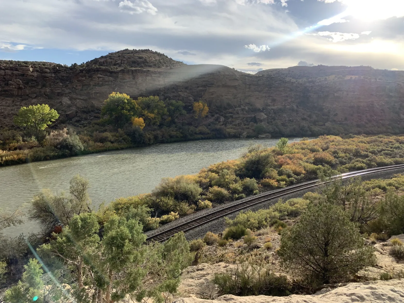


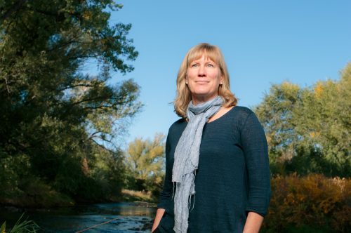


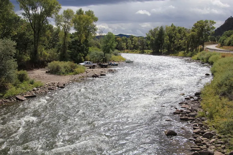
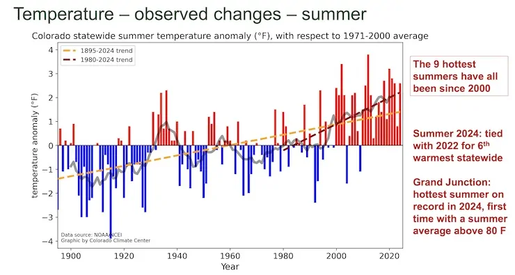

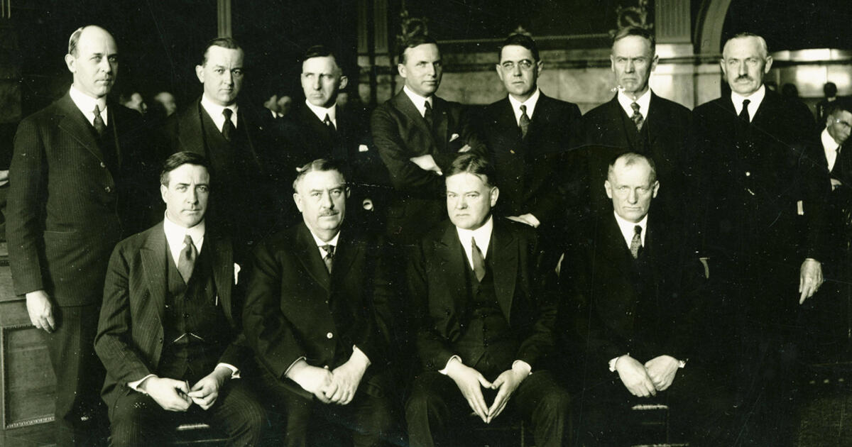
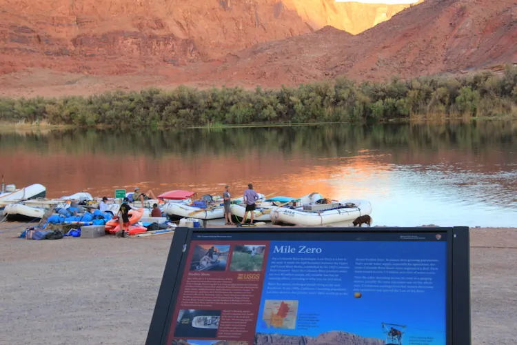

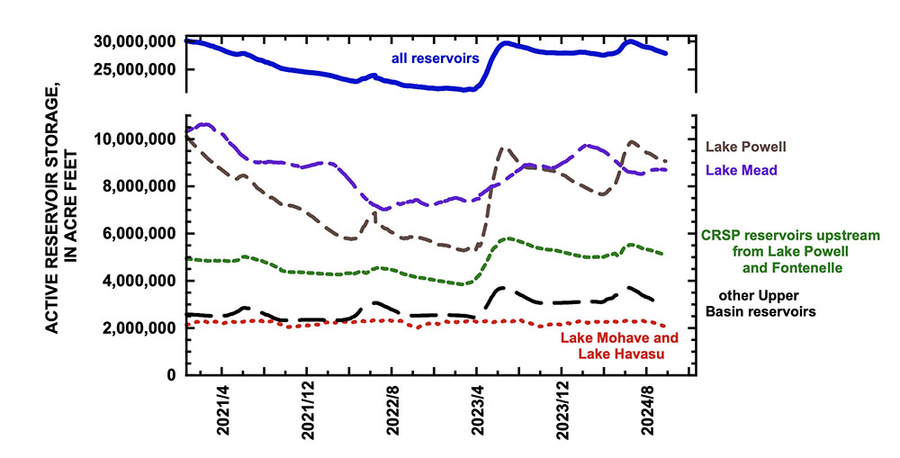


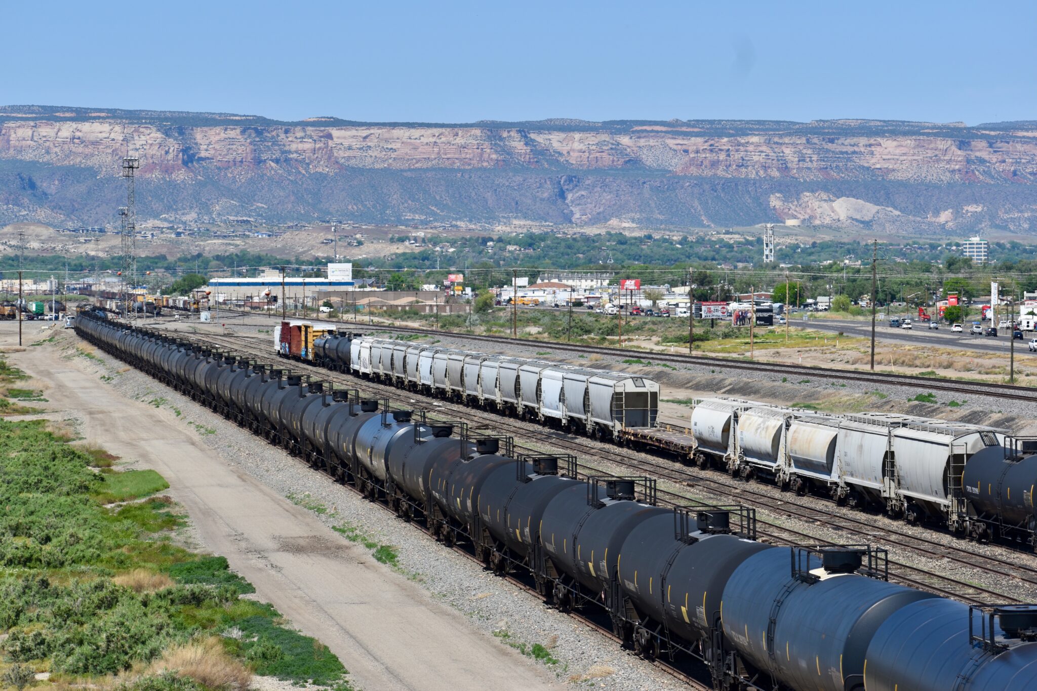


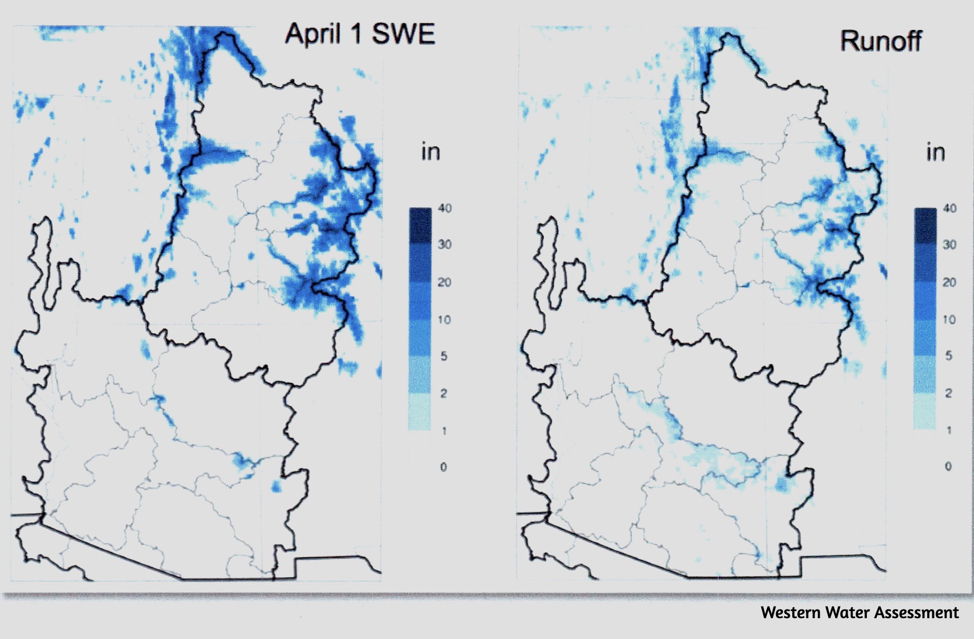


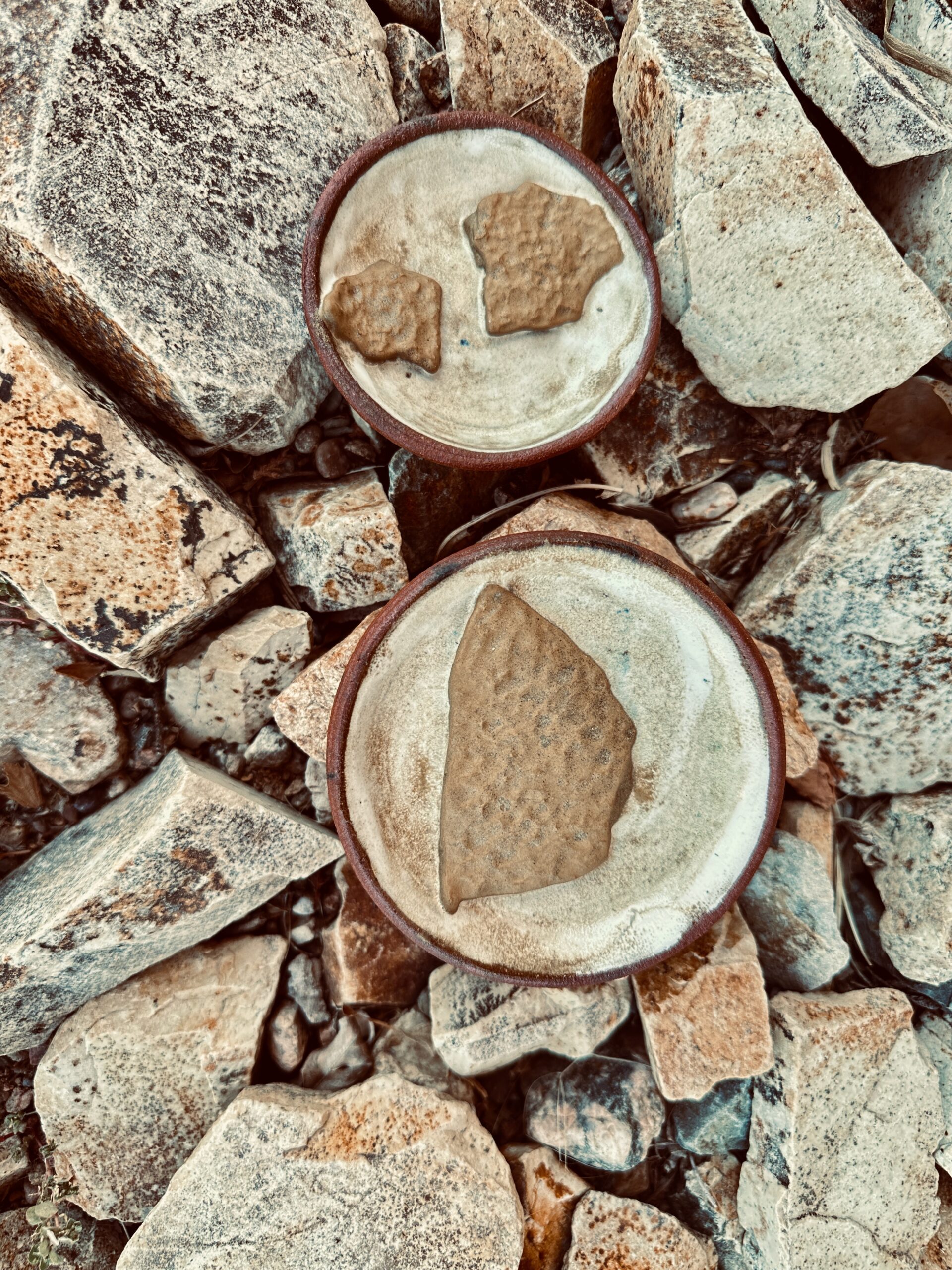


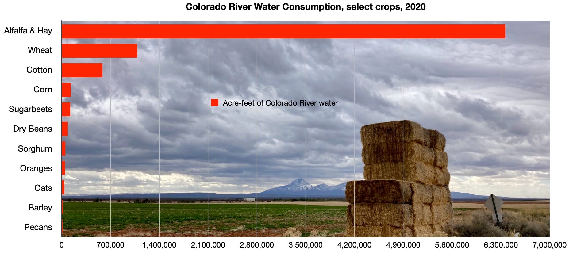
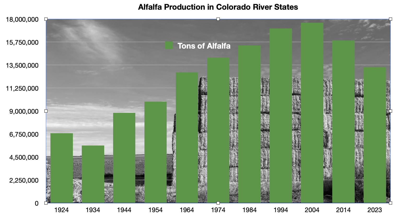
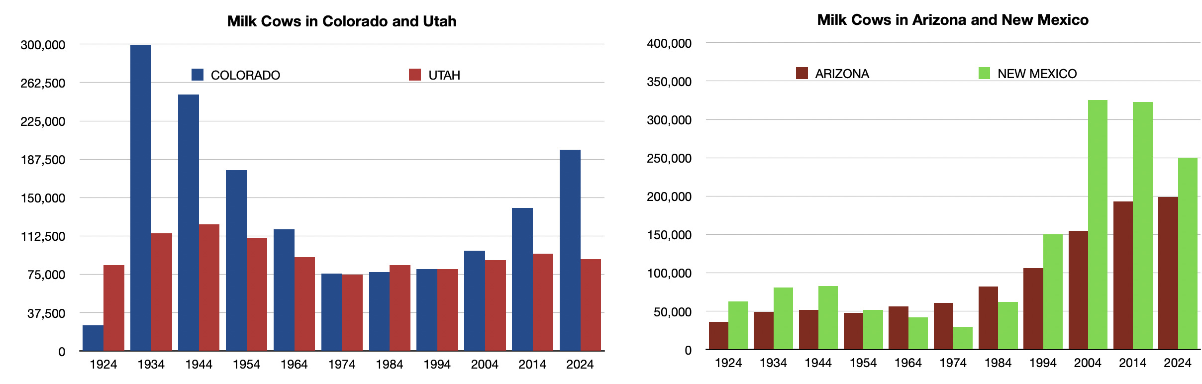
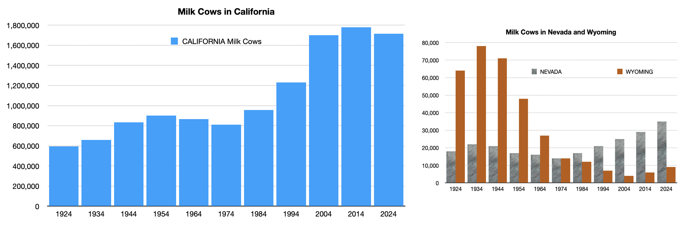
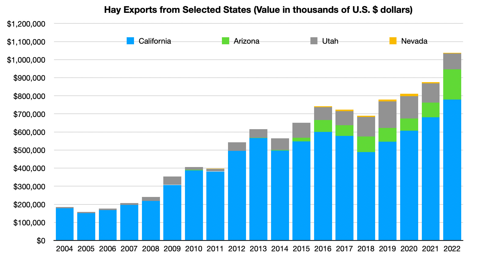
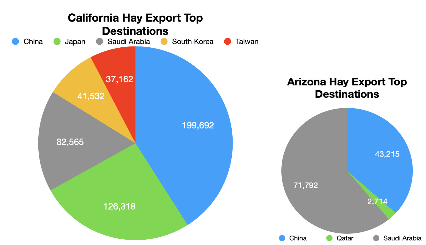


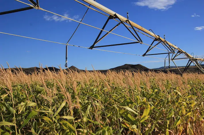

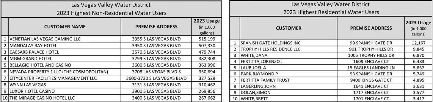
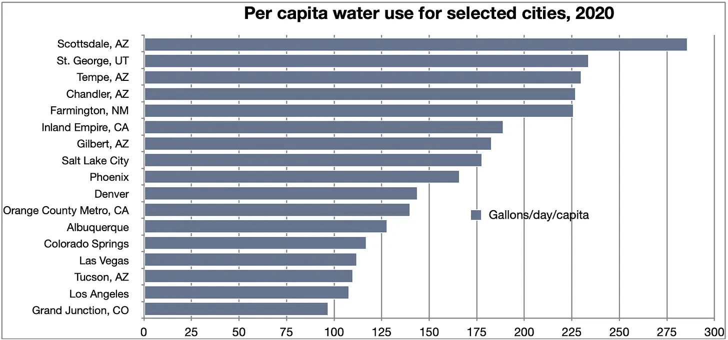
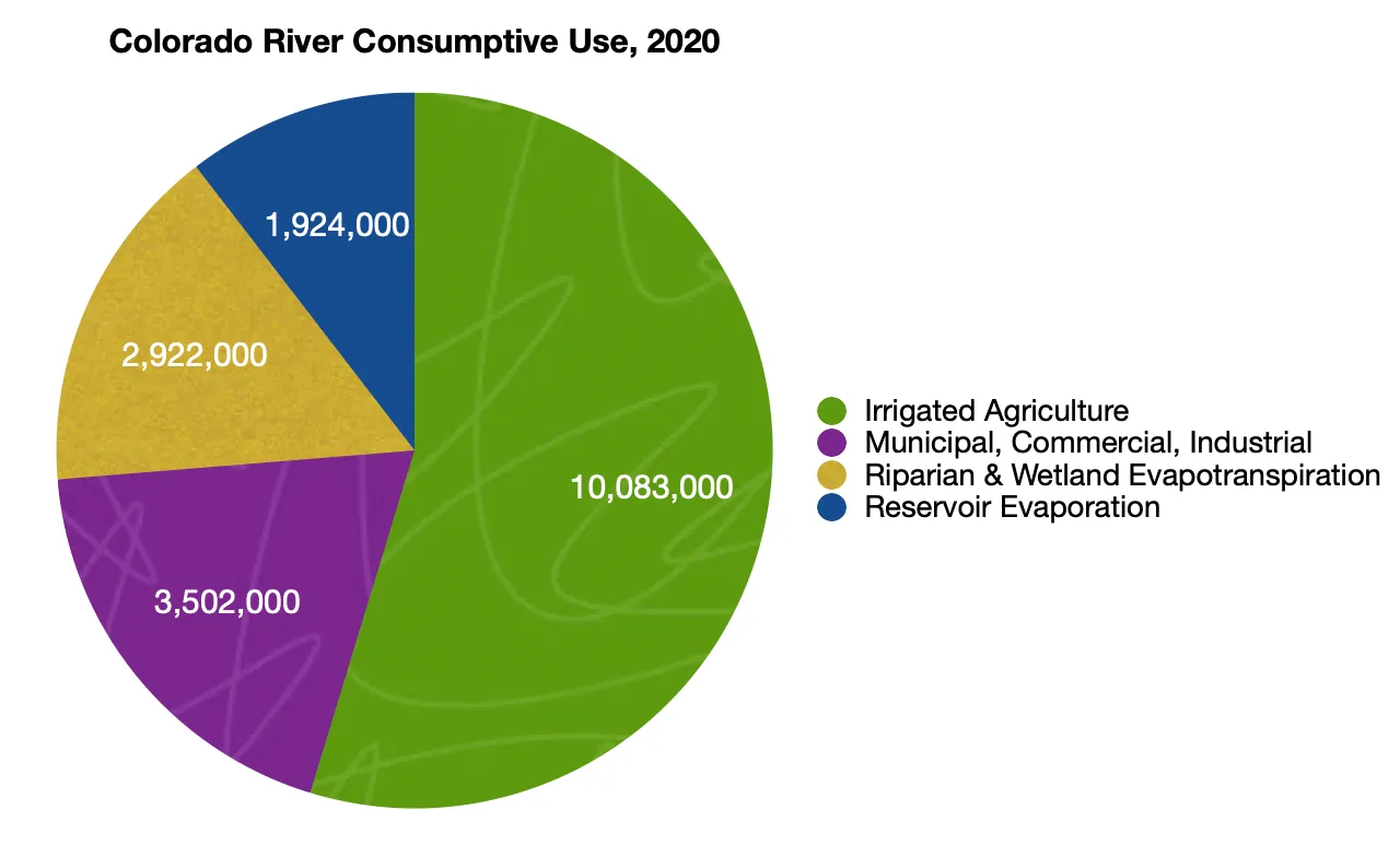
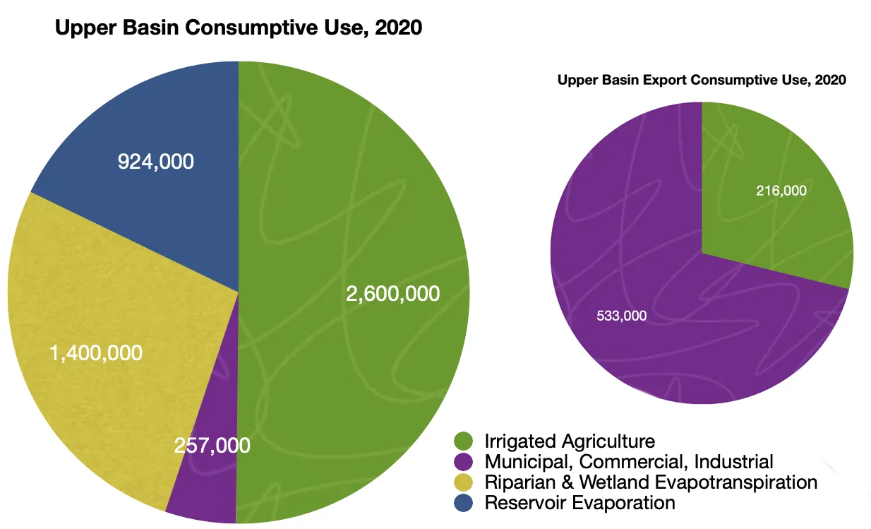
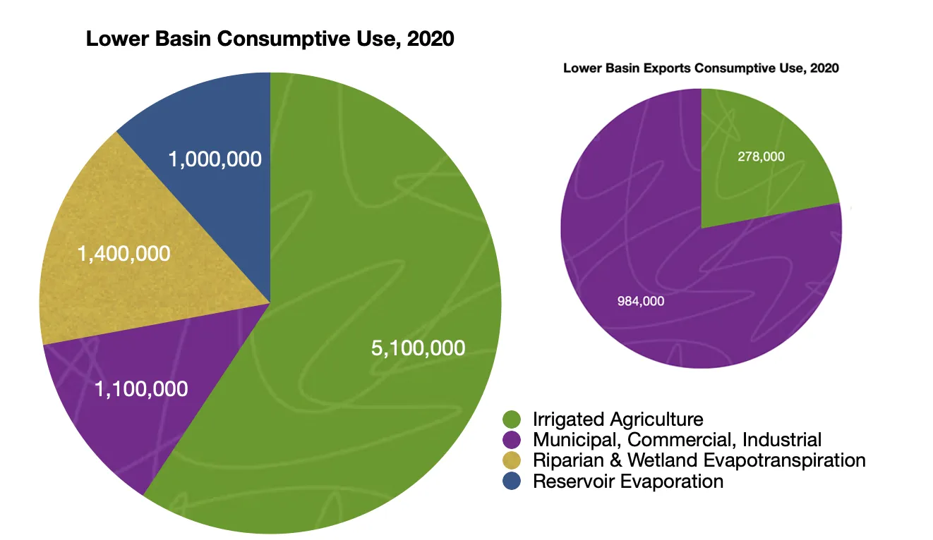
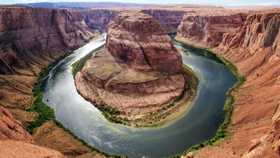

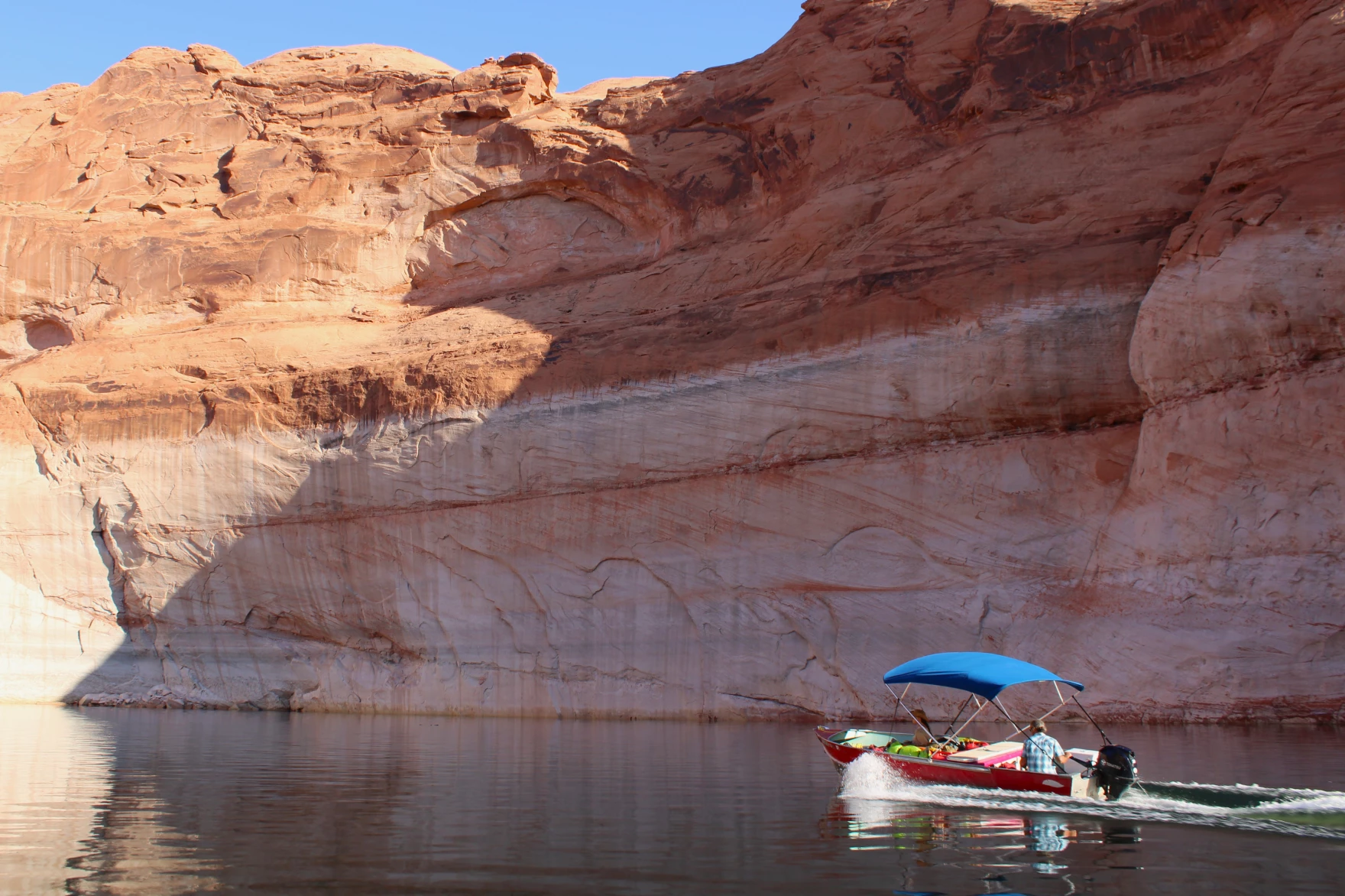


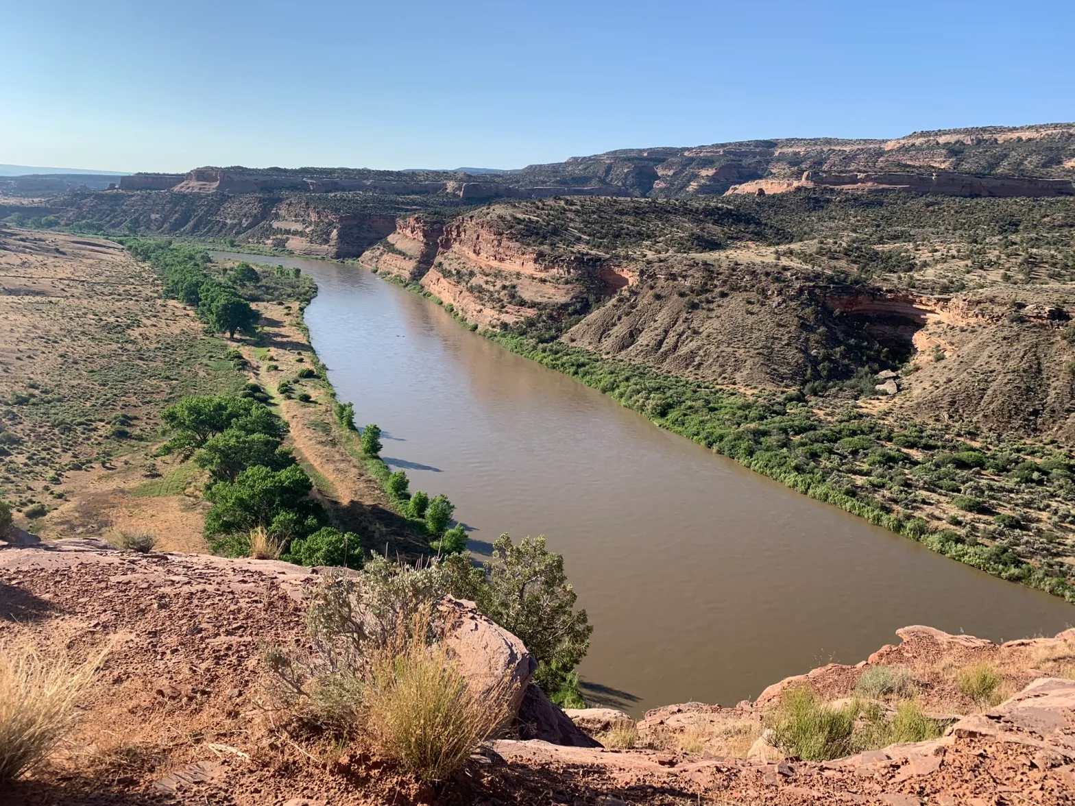


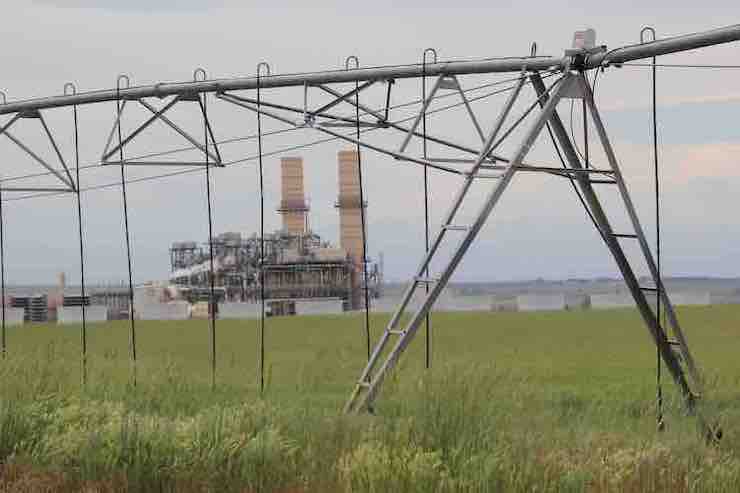


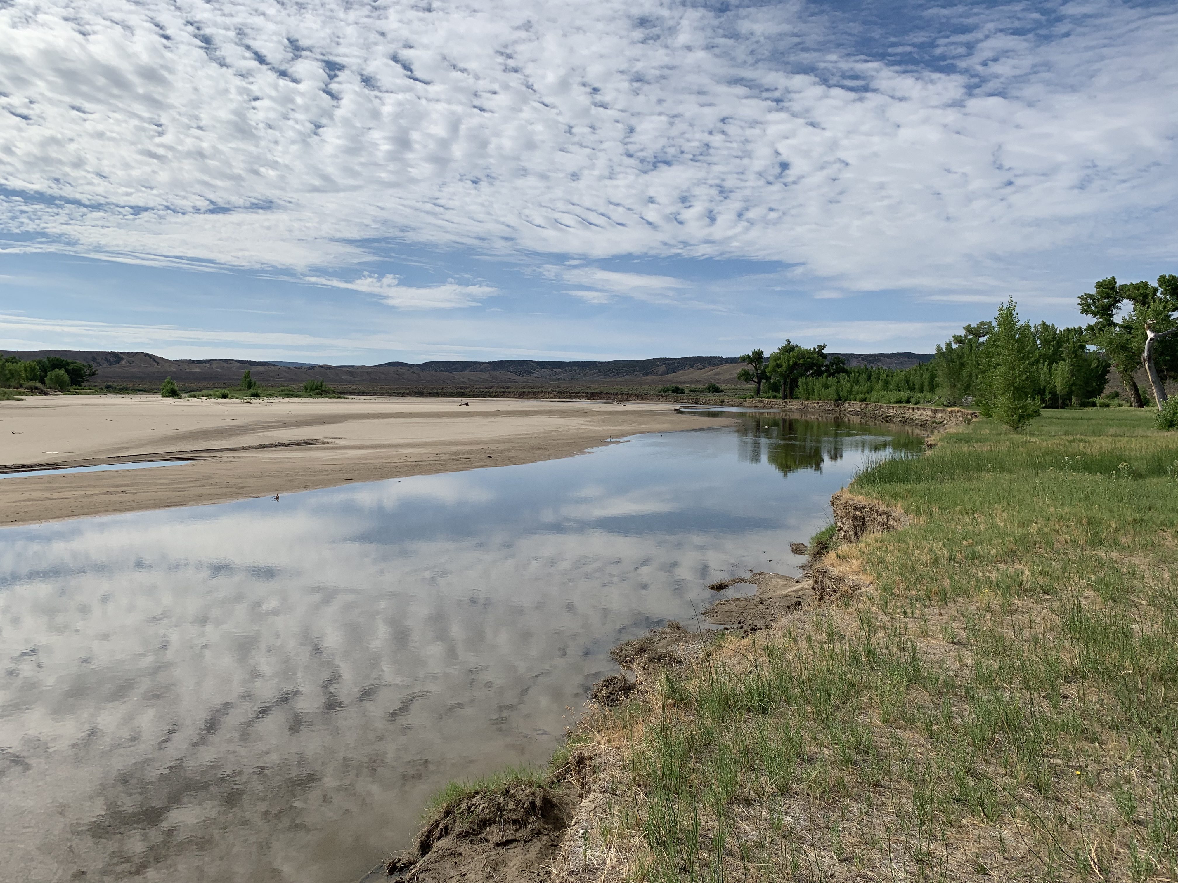

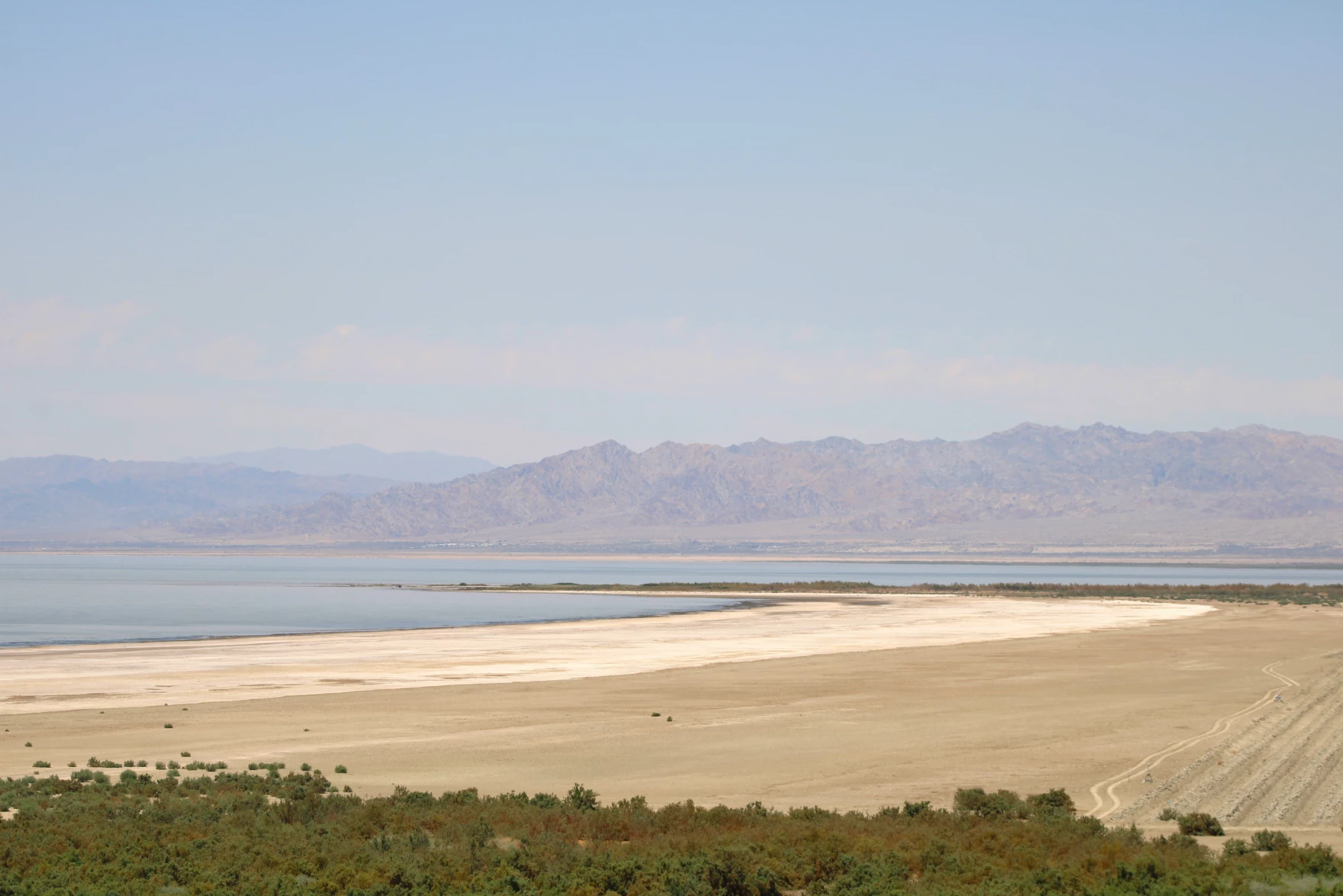
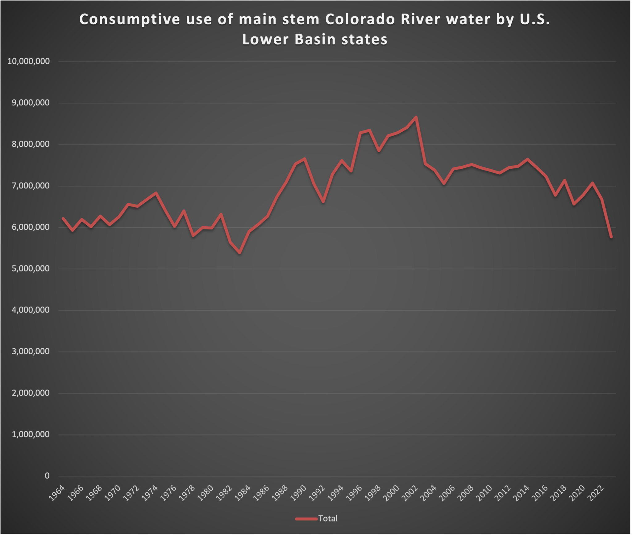


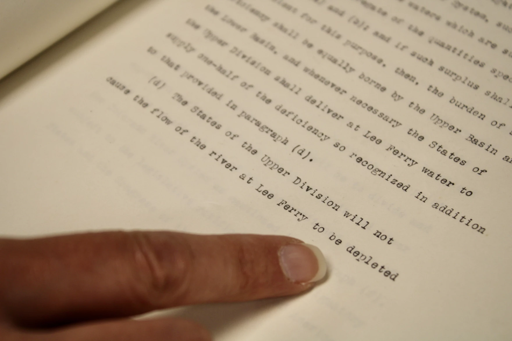
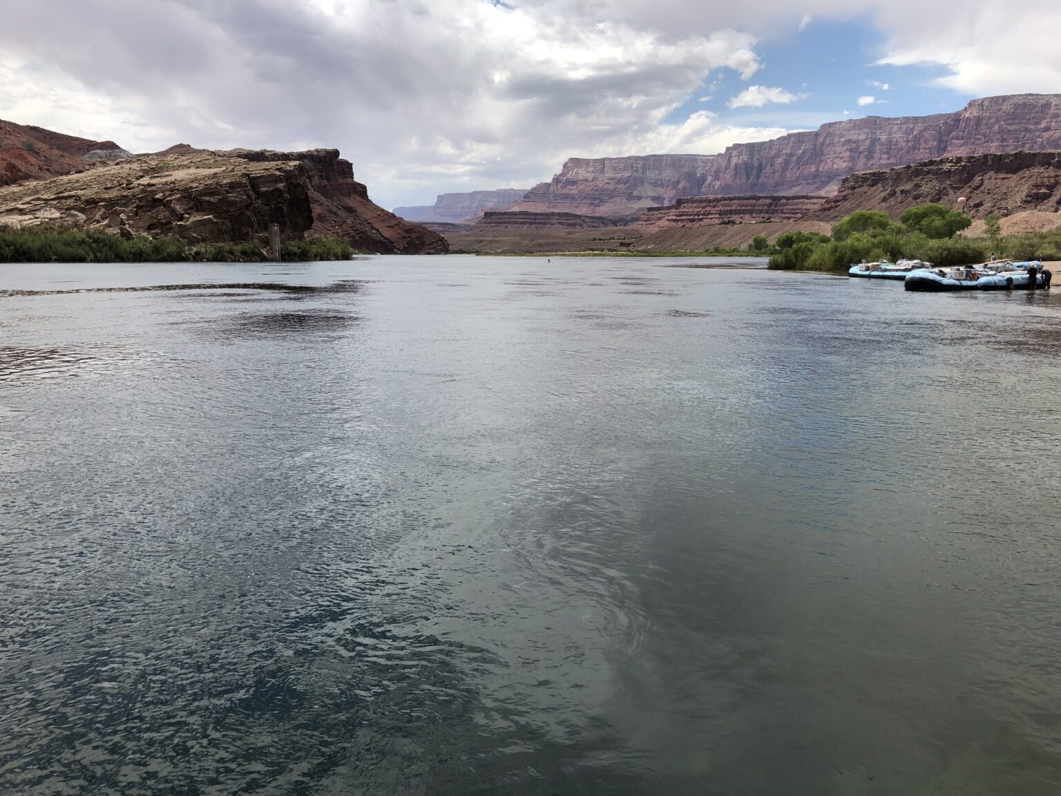

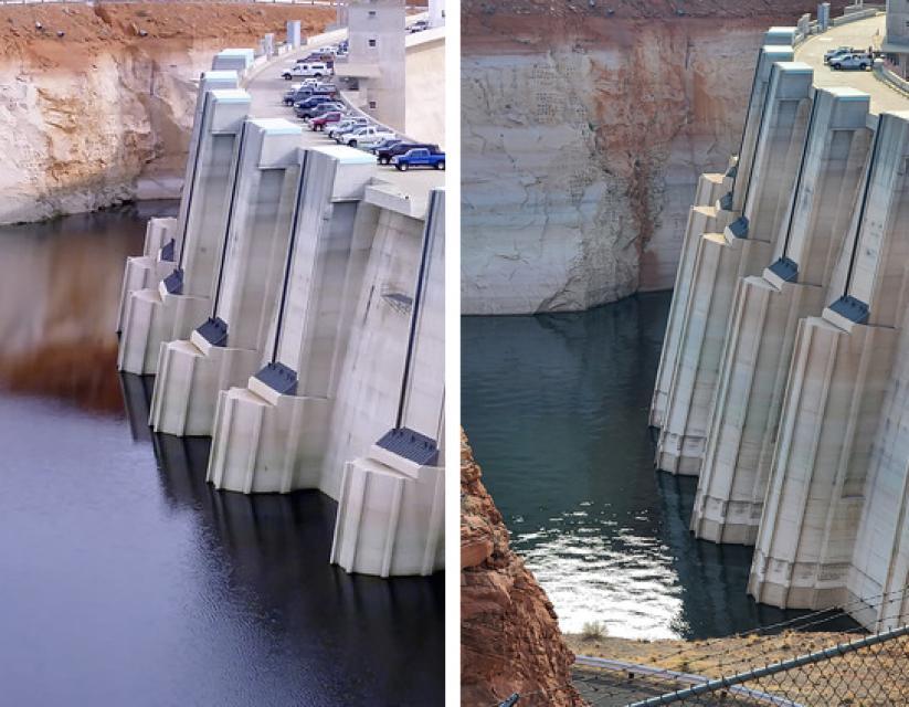


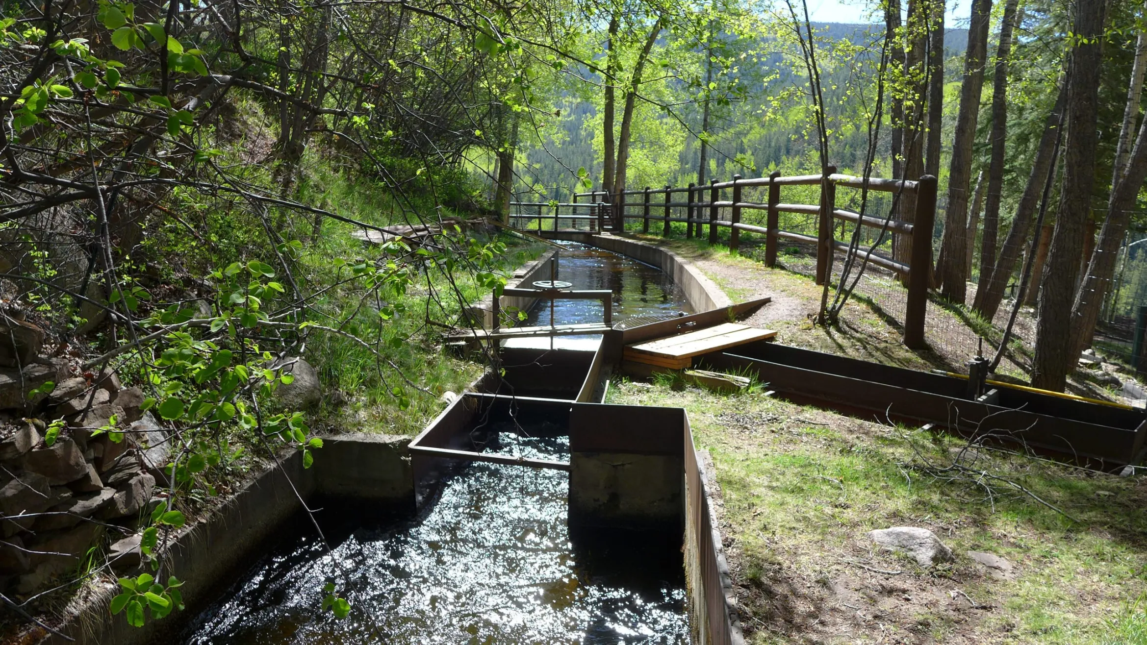
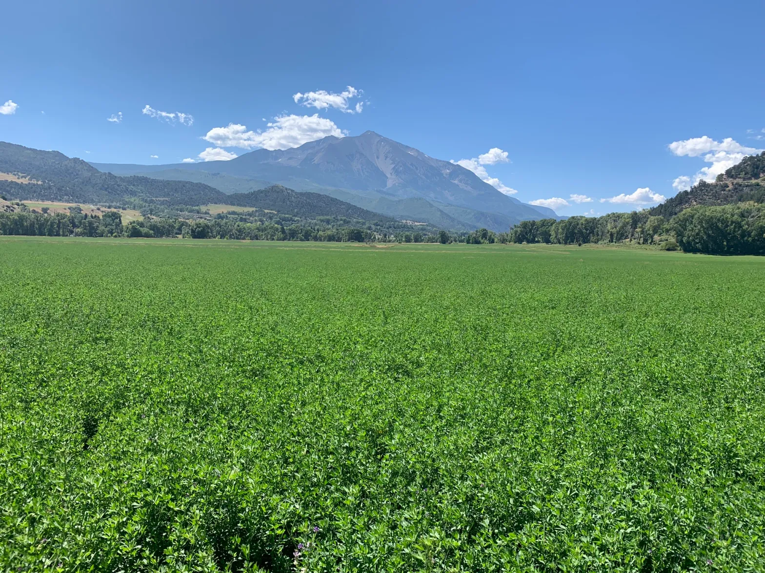

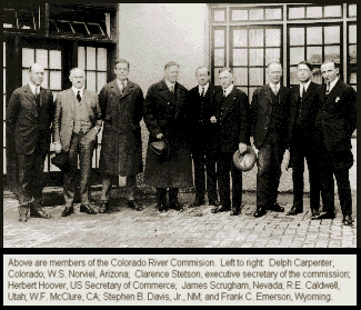
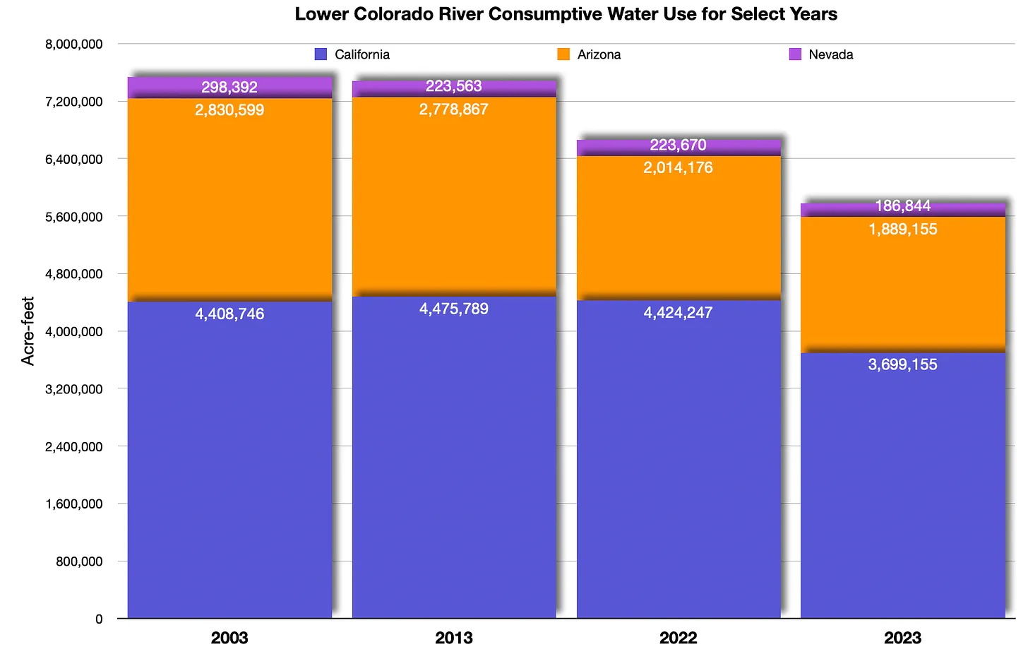
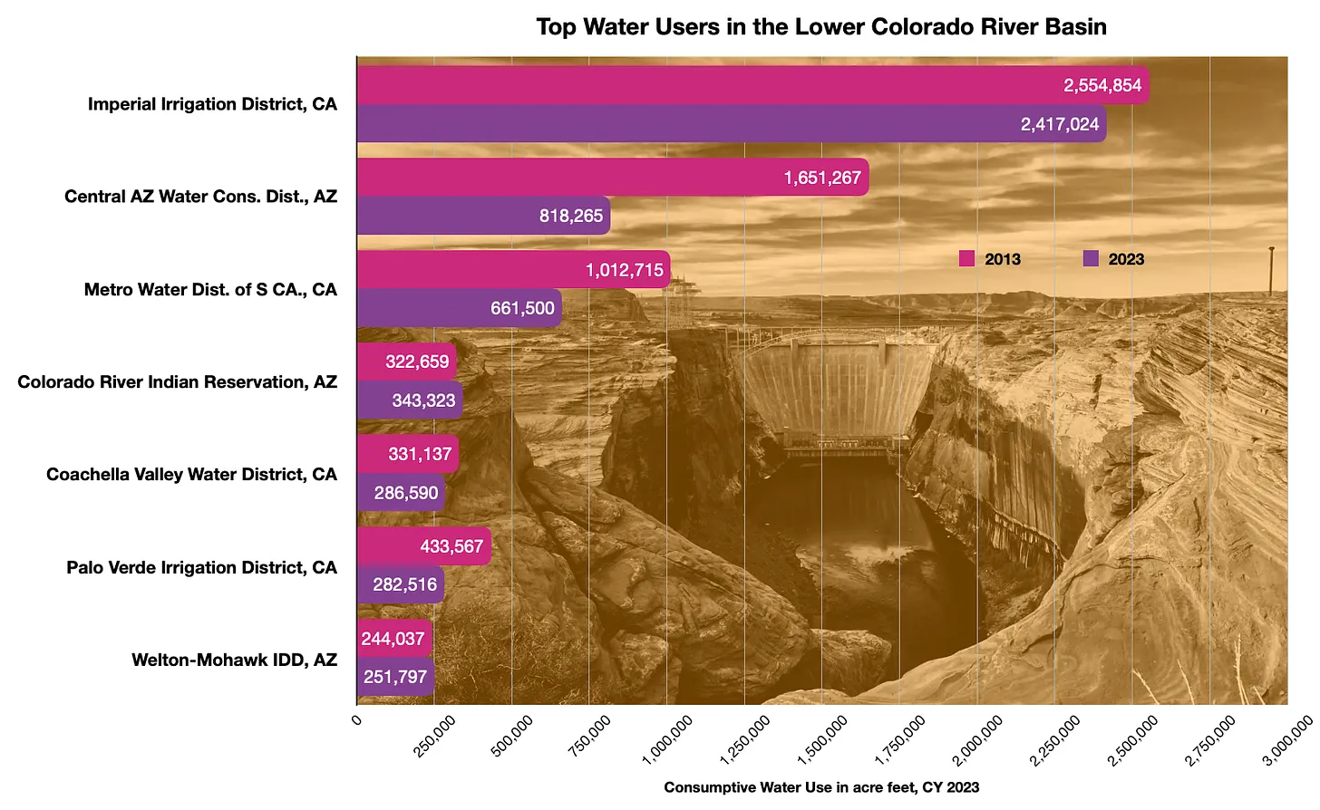
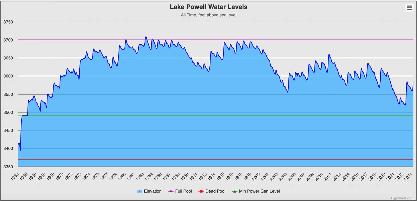
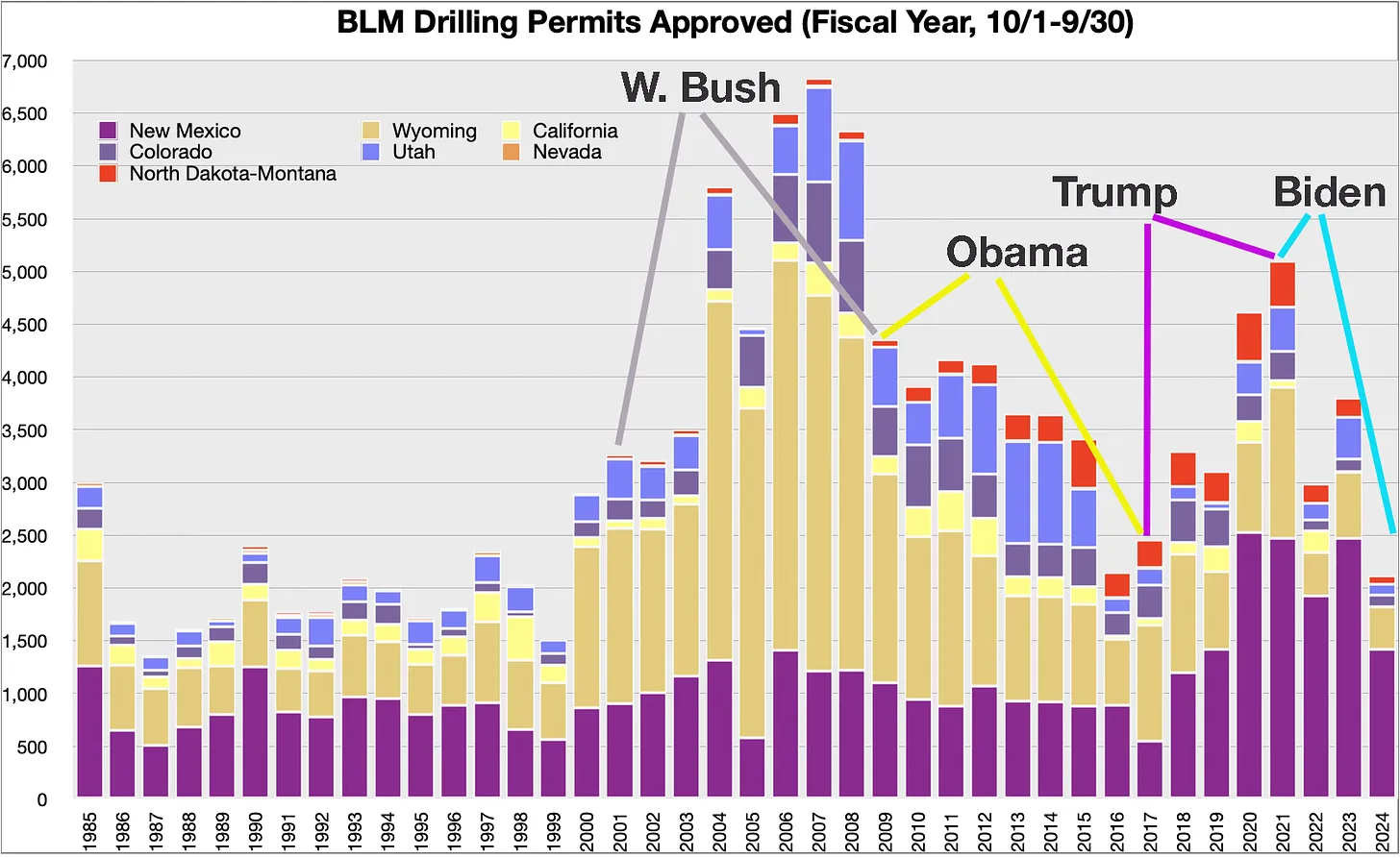


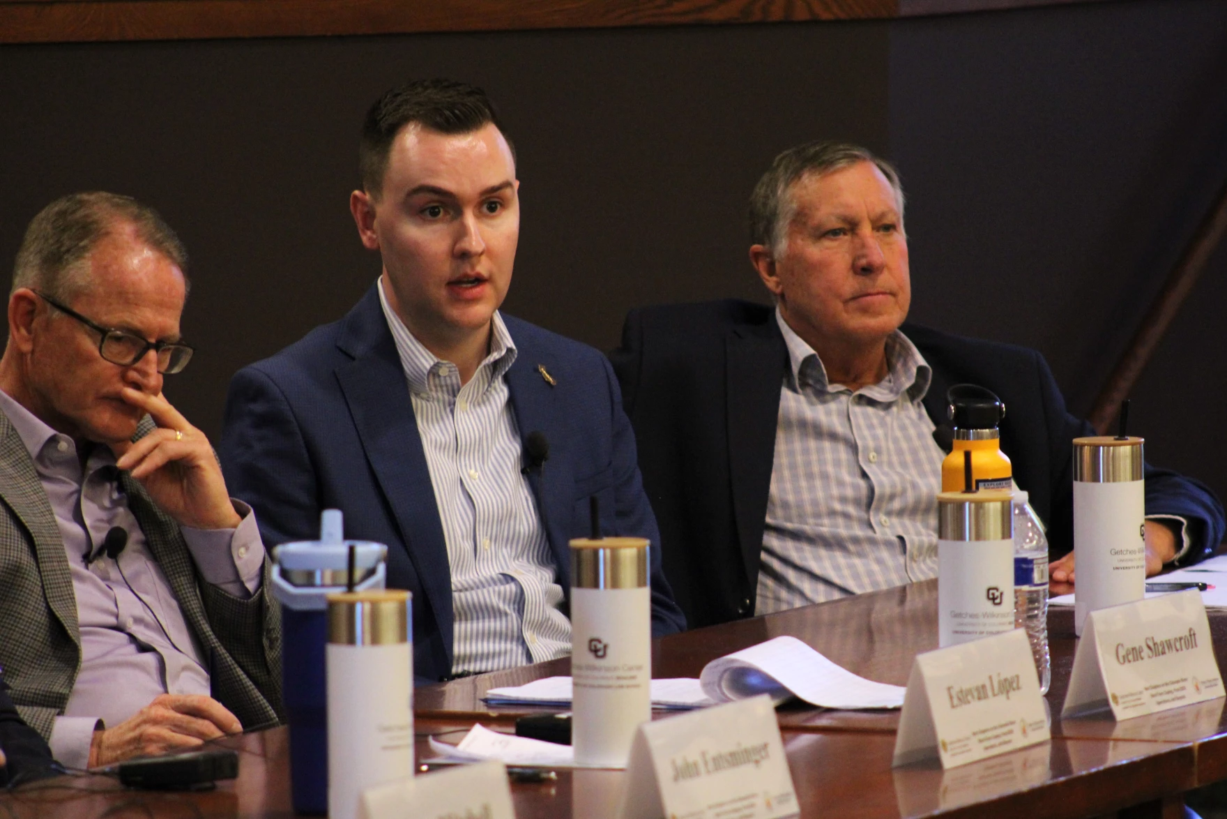

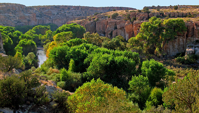


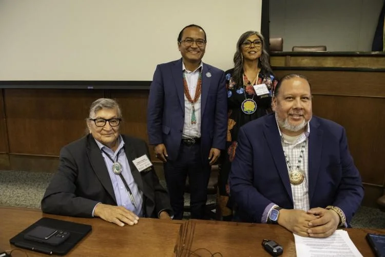
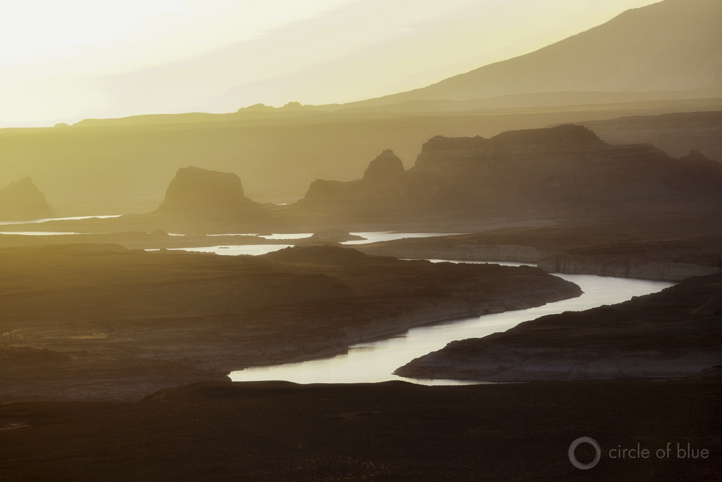


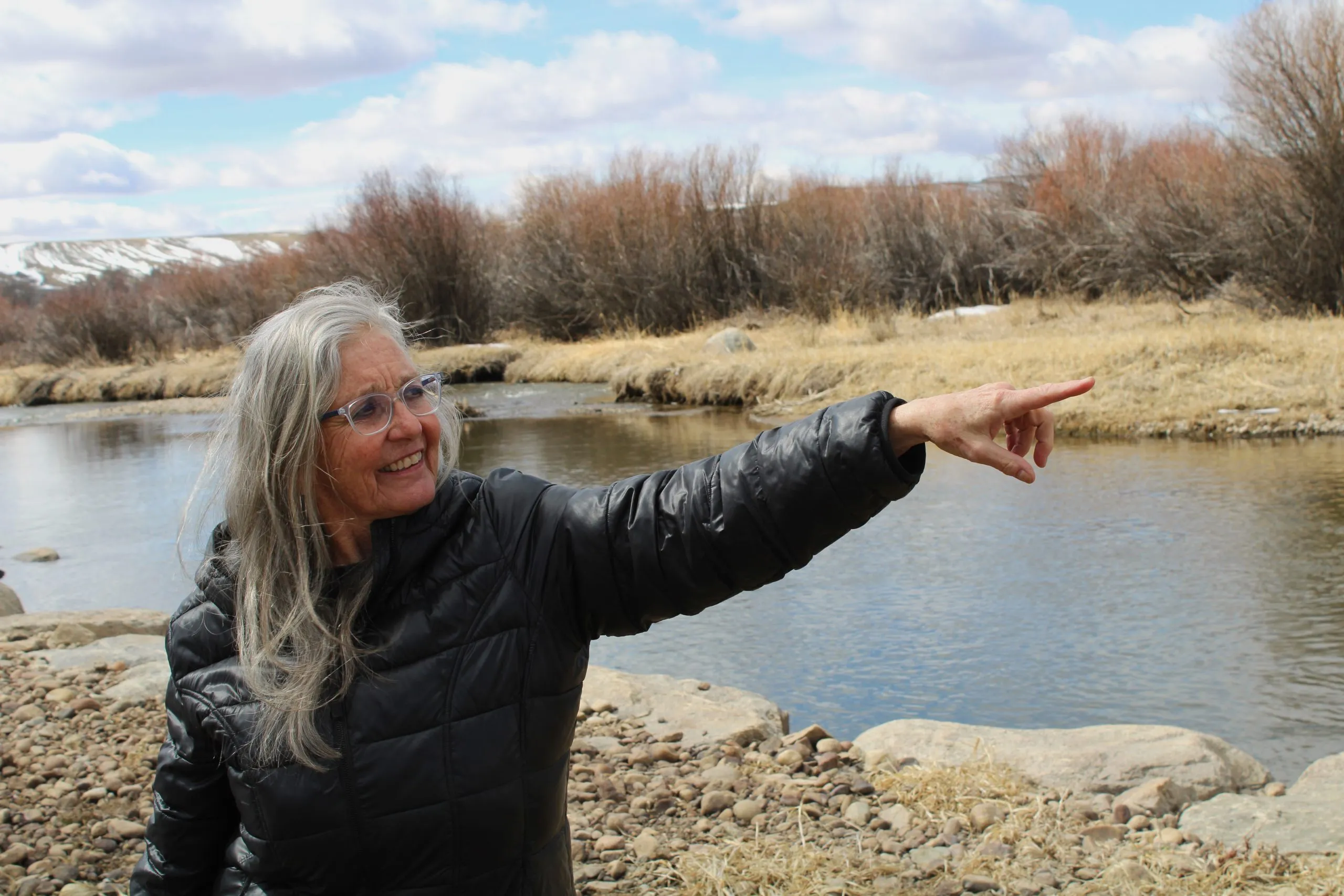
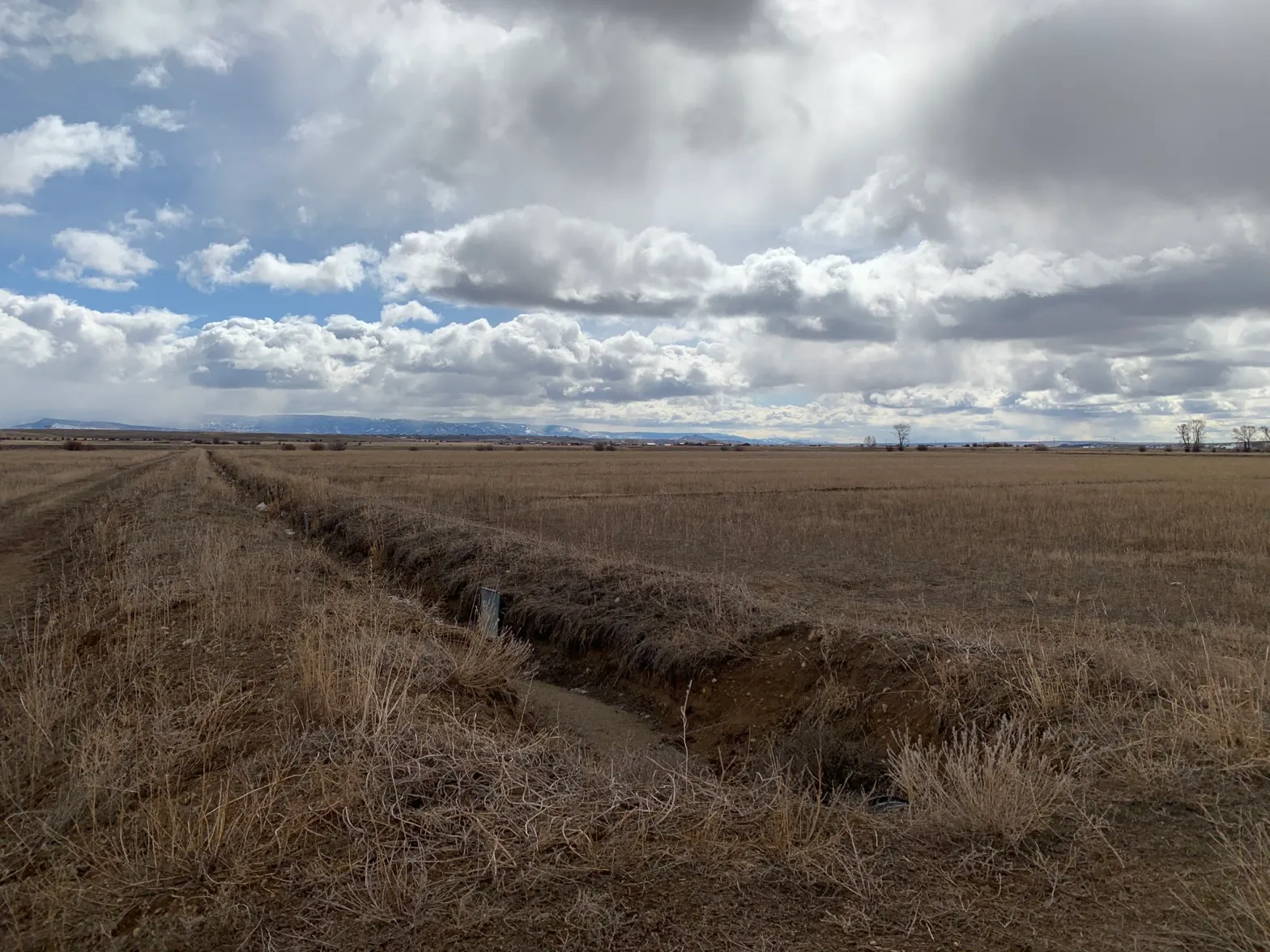
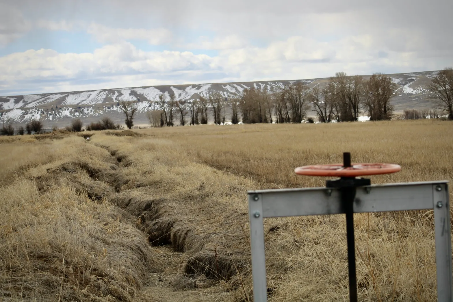


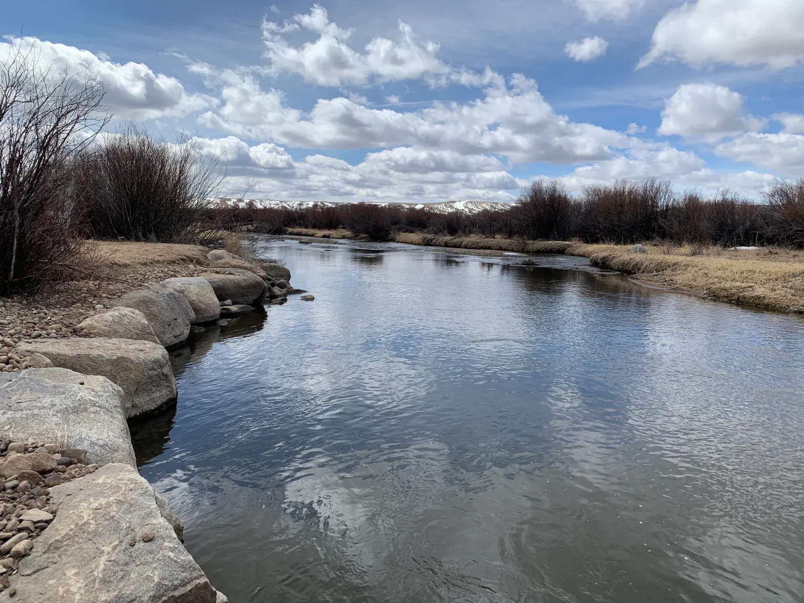
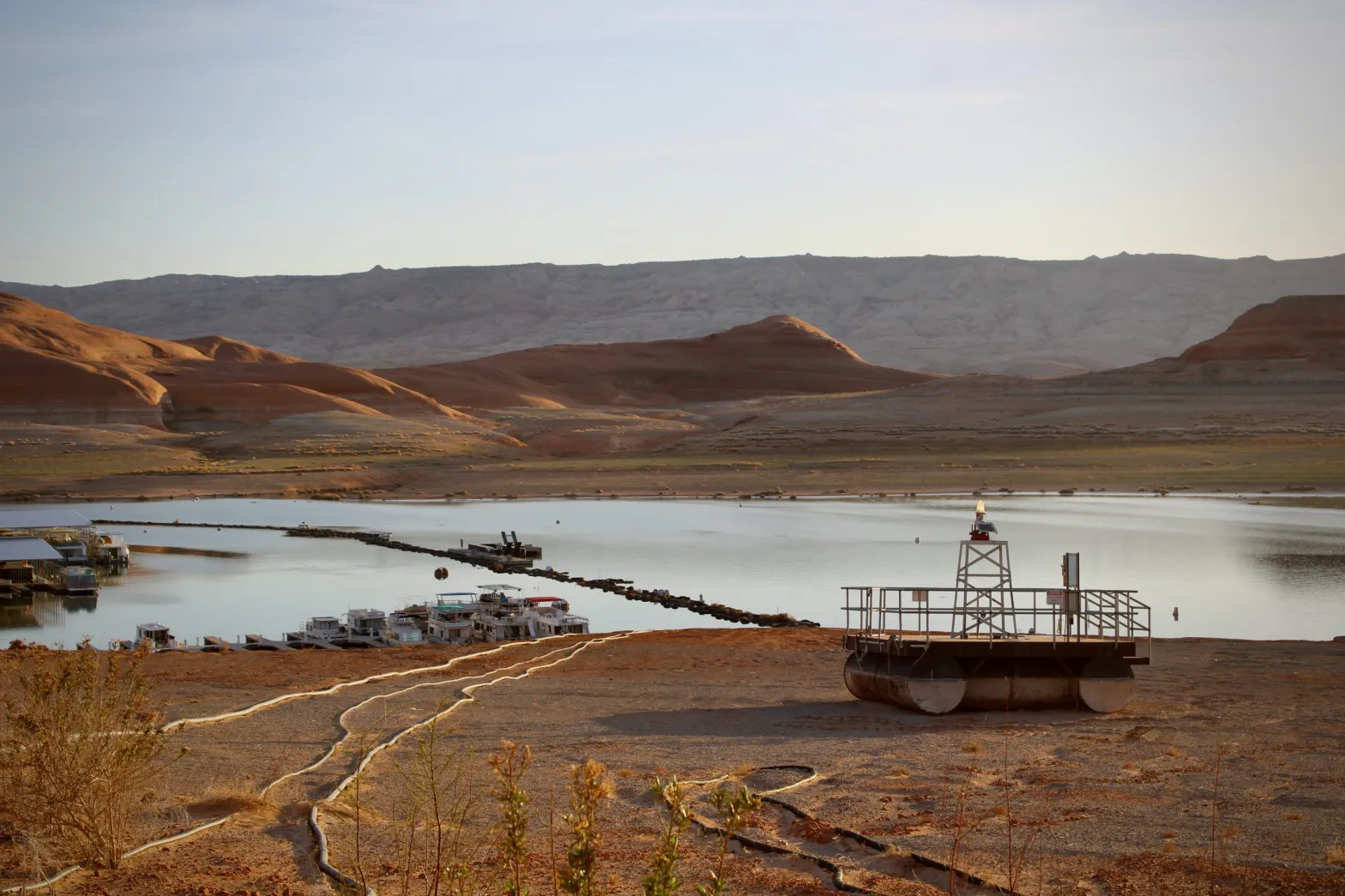


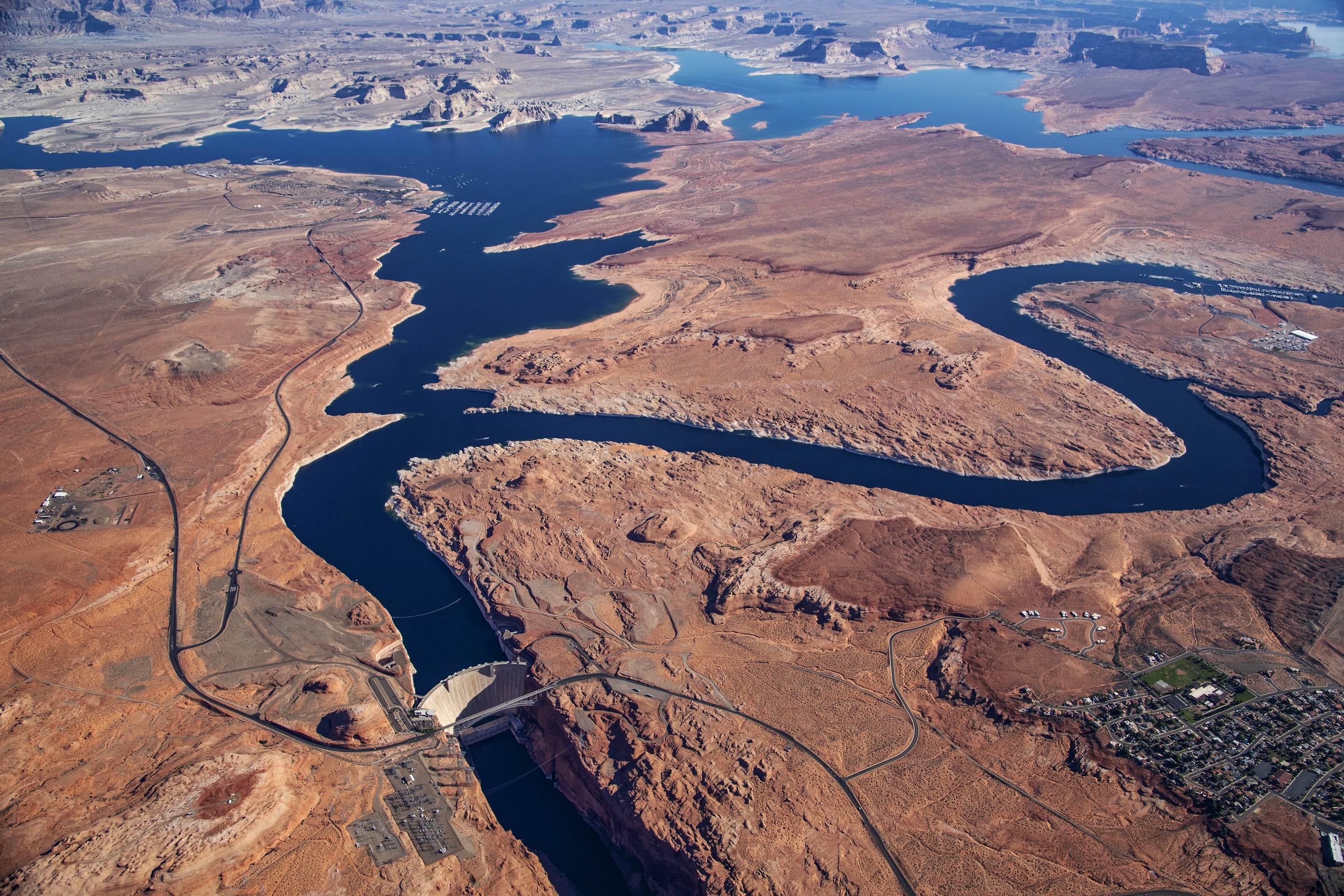
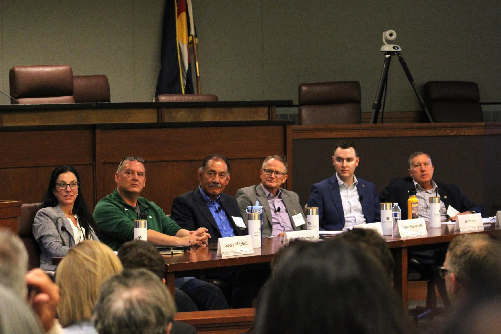
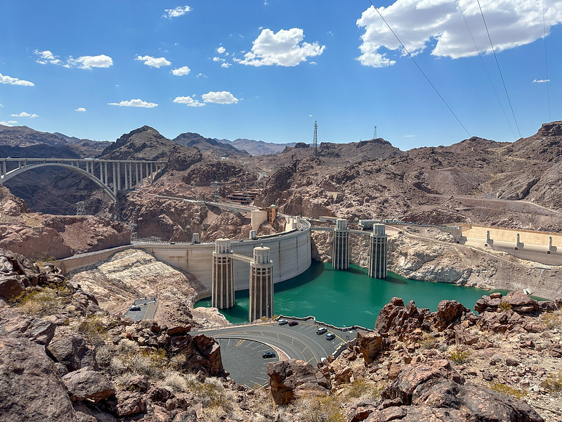


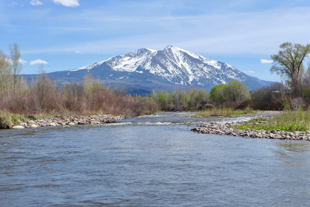
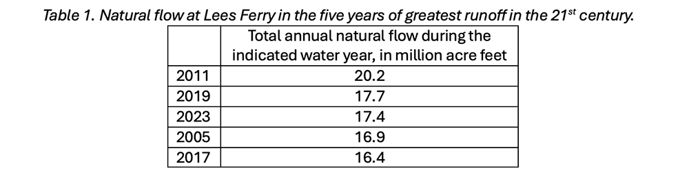
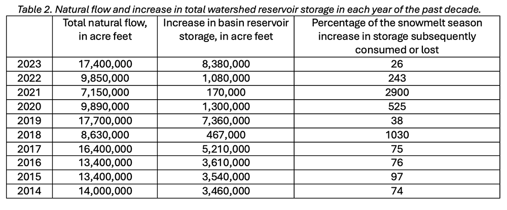
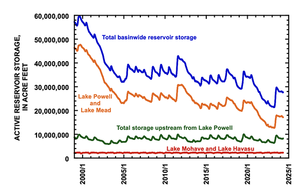
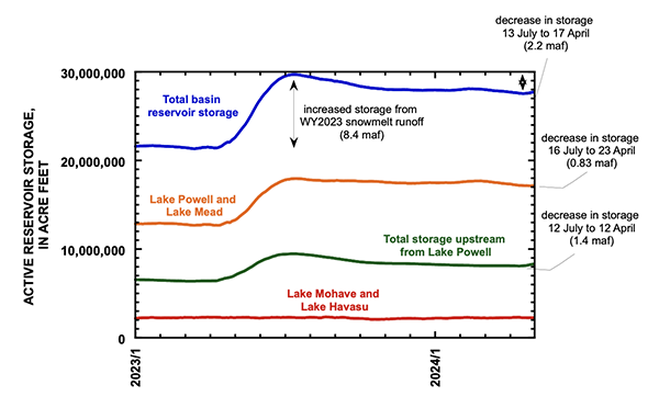
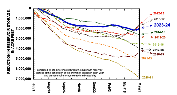
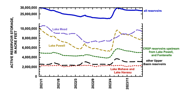


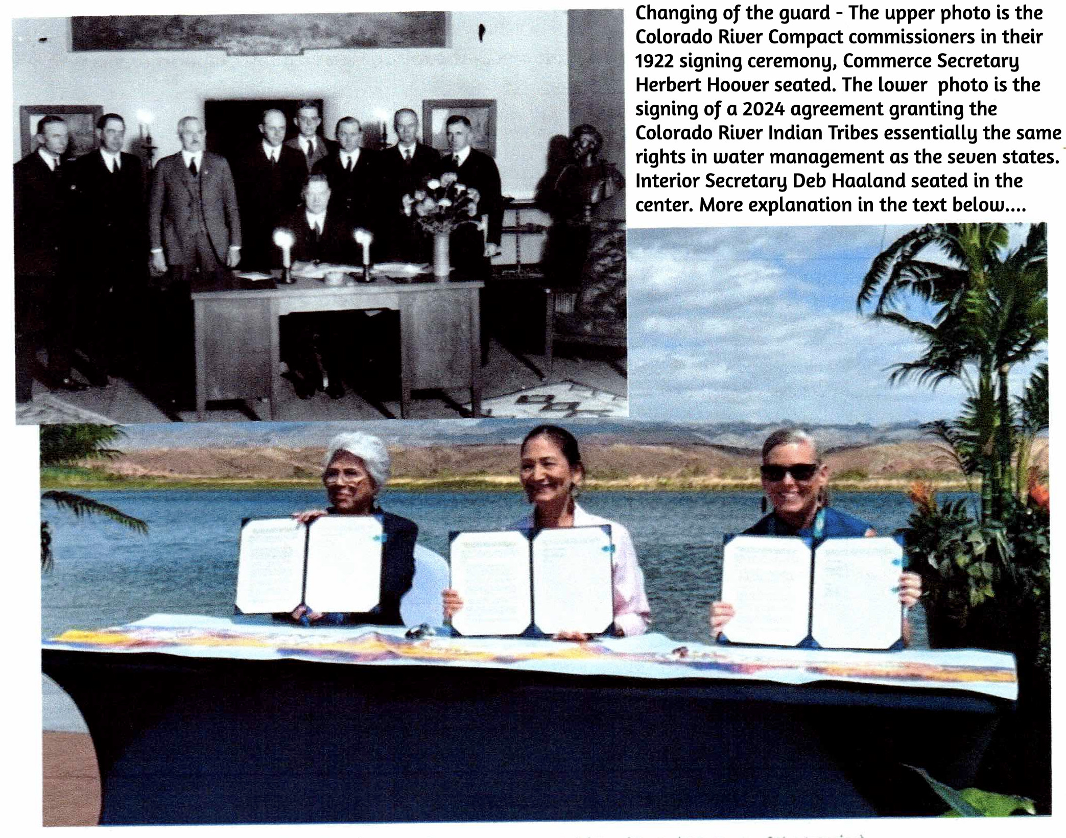

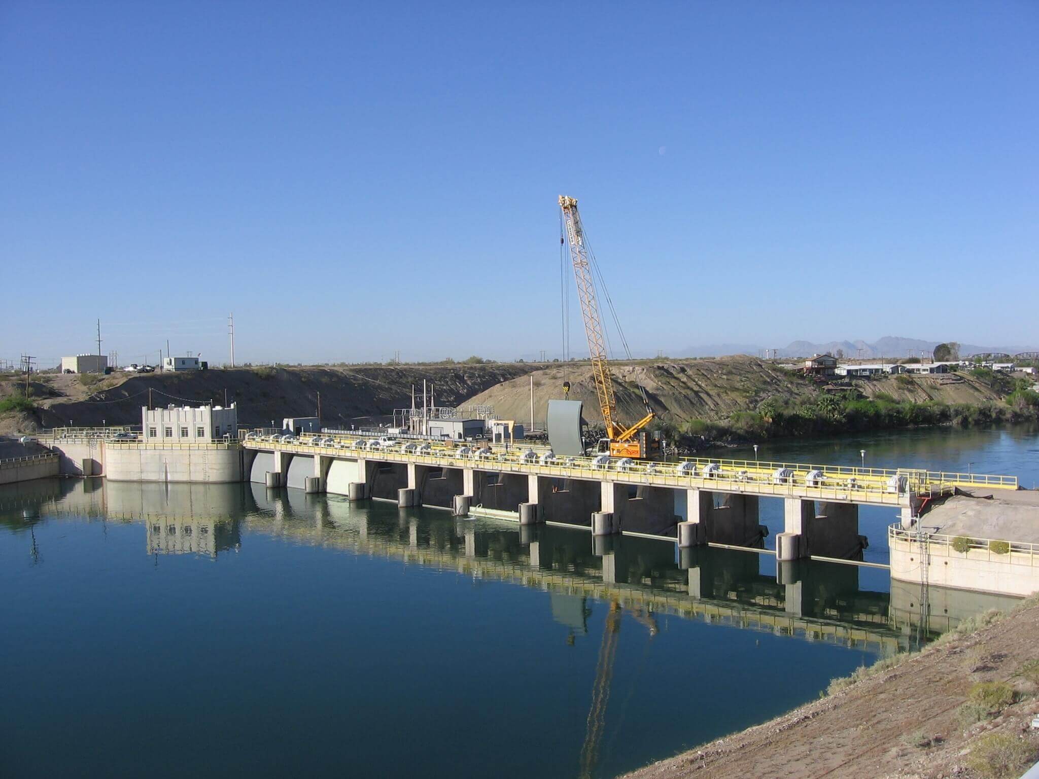
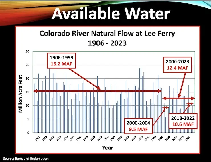

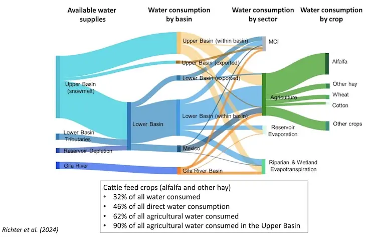
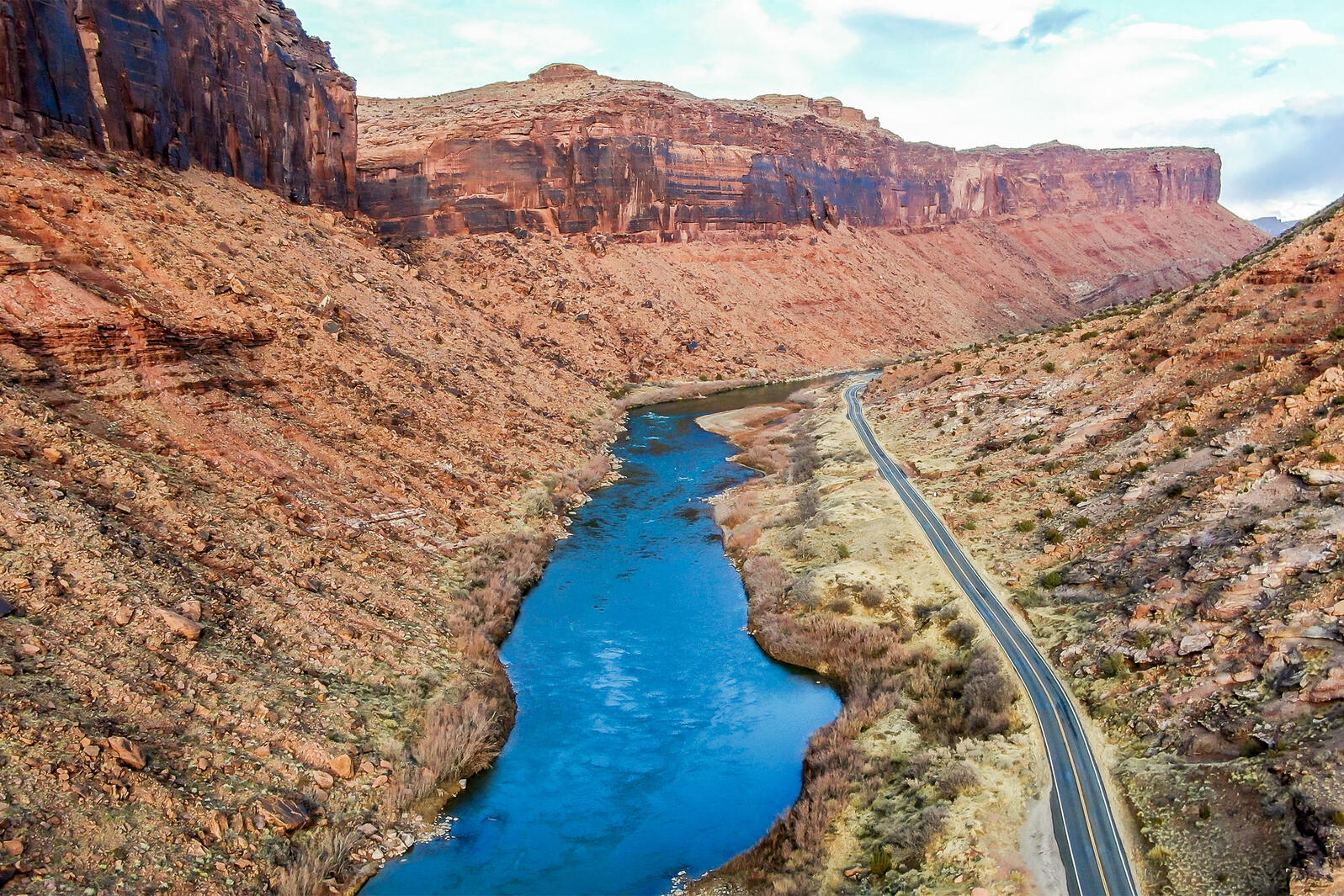