Colorado River May 2023 swelled from low elevation snow runoff.
Click the link to read the article on the KJCT website. Here’s an excerpt:
July 28, 2025
On Monday, the Colorado Basin Roundtable had a meeting to discuss the state of the Colorado River. The Roundtable discussed the potential Shoshone stream flow acquisition. The area of interest is the 2.4 miles in Glenwood Canyon. It is important for Western Colorado because of its stream flow rate that mimics the current water rates used for hydropower. Wildlife organizations did habitat studies on it, and they show it improves the natural environment.
Another topic of discussion was the basin hydrology. With a limited snowpack this year, there is less water. The biggest concerns people had in the meeting related to that was the stress of many systems struggling from prolonged drought and aging infrastructure. Lindsay DeFrates, Deputy Director of Communications for the Colorado River District, said, “The Colorado Basin Roundtable is a great example of a room where a bunch of different stakeholders from agriculture, recreation, environment, municipal, industrial, water users all come together to talk about those solutions. It’s never an easy conversation. And we can’t forget about zebra mussels. Zebra mussel veligers were found at the Silt Boat Ramp and near New Castle.
Last week, one of the Land Desk’s more conservative readers cancelled his paid subscription. He wrote that he appreciated my passion for public lands, but was no longer interested in reading what he called a “tirade against Trump.”
This type of thing happens all the time in this business, and, unlike Elon Musk, I’m not looking for your pity. But I was a bit saddened, given that this person had been a paid subscriber since the Land Desk was launched, and because I really do appreciate having readers and commenters from across the political spectrum.
Besides, while I’m prone to a rant now and then, I do think “tirade” is taking it a little too far. Anyway, my point in telling y’all this is to let you know that writing about Trump’s shenanigans every dispatch is just about the last thing I want to be doing with my time. I’d much rather be delving into old maps, getting into the nuances of Western water, exploring the history of floods and droughts and wildfires, taking contrarian views on the housing crisis, or dissecting the contradictions of oil and gas markets. And I will continue to do all of that.
At the same time, it’s impossible for me to ignore the barrage of destruction, corruption, chaos, authoritarianism, and incompetence emanating from the White House. My passion for public lands — and for justice, truth, reason, morality, decency, intelligence, and kindness — demands that I document these egregious acts, and do my part to resist them, even if it is just by informing my readership about what’s happening.
I am not impartial, not by any means. I am partial to the planet and its survival, toward my fellow human beings, toward peace and justice and compassion and truth. [ed. emphasis mine] I am not, however, partisan: I will scrutinize Democrats and Republicans equally, fact-check the left and the right, and give credit where credit is due — even to Donald Trump.
***
Hopi tribal members cross Havasu Creek. Photo credit: From the Earth Studio
And on that note: The Trump administration appears to have unfrozen nearly $4.2 million in federal funding to help the Hopi Tribe build a solar-powered microgrid to run two remote wells and associated infrastructure that will provide water to Upper and Lower Moenkopi. The funding was approved by the Biden Energy Department, Trump froze it as part of a larger stop on Infrastructure and Inflation Reduction law money, but now it has been released. So good on you, Donny!
Though it may be inadvertent, Trump’s economic policies may ultimately benefit the environment in some ways. The haphazard, on-again, off-again tariffs, for example, along with the gutting of the federal government’s workforce, have sent the stock market into a tailspin. Meanwhile, the tariffs — along with reciprocal tariffs levied by the U.S.’s trading partners — will increase prices on most consumer goods. People will buy less, travel less, which will mean less pollution and environmental impacts.
***
And yet more kudos for Trump! Seriously. Despite all of his bluster, Trump has managed to really piss off oil and gas executives — the same ones that were throwing money at his campaign just a few months ago — and possibly dampen drilling on public lands.
See, the thing about tariffs is that they very well may raise the price you pay for gasoline (depending on where your local refinery gets its crude oil), but the economy-dampening part of tariffs actually brings down the price of oil, while also raising the cost of steel pipes and other supplies. That’s no bueno for petroleum companies, whose profit margins are directly proportional to the price of crude.
Many of these folks won’t criticize Trump in public, given his vindictive and authoritarian leanings, but give them the cover of anonymity, as a Dallas Federal Reserve survey did, and they go off on the White House’s herky-jerky non-policies. Here’s a sampling:
There was only one mention of regulations getting in the way of the oil business, and that wasn’t federal rules, but state ones:
Well, there you have it, folks.
***
Oh, and these oil companies might also be angry that the MAGAs are all buying Teslas — or at least pretending to — in order to “own the libs.” Which is pretty funny, given the amount of gibberish Trump devoted to dissing electric vehicles during his campaign rallies. Tesla also stands to benefit the most from Trump’s tariffs, another dig at the internal combustion fans.
***
Maybe the national parks will be a bit less crowded this summer, as well, as international travel ebbs.
Anyone who’s traveled the Western national park service knows that they are popular with overseas visitors. On a single grocery run at the Page, Arizona, Safeway recently, I heard no fewer than three different languages spoken, in addition to Navajo and English, and that was in the off-season. In 2018 (the last year that data is available), more than 14 million international travelers visited U.S. national parks and monuments. About 14% of the Grand Canyon National Parks’ visitors were from overseas, with about 6% of Zion’s visitation from overseas.
Tourism Economics is predicting that international travel to the U.S. will be down significantly this year, thanks not only to the administration’s hostile economic moves, but also “polarizing Trump administration policies and rhetoric.” Also, there’s that thing where travelers have been detained at the border, even thrown in jail, simply for trying to get a visa. This decline undoubtedly will impact Western U.S. tourism and national park and monument visitation numbers. Not good for the tourism economy, but it might give the parks a much needed rest.
🥵 Aridification Watch 🐫
It’s first-of-the-month snowpack update time again, and this will likely be the last of the season barring some freak climatic shift over the next several weeks. Snowpack levels typically peak in mid-elevation areas in mid- to late-March, and in the high country in mid- to late-April, meaning we are now headed into spring runoff season.
Generally speaking, it’s looking like runoff will be average to paltry, depending on which side of the snow-divide your watershed falls. It is a very jagged line, by the way, with places in the west and north having average to above average snowpack, while the southern-Interior West generally had a super dry winter. But even within those areas there are sort of outliers: The Grand Traverse ski race between Aspen and Crested Butte was canceled due to lack of snow for the first time in its 26-year history.
And there’s big variations over short distances. Red Mountain Pass is still just below median, for example, while the southern San Juan Mountains, just a few dozen miles away, are experiencing a severely dry winter.
Before I get to the graphics, however, a quick note. The snowpack and precipitation plots I run here come from the USDA’s Natural Resources Conservation Service. It’s just one of the valuable services they provide. I haven’t found any stats on whether DOGE has gone after NRCS’s staff, yet. But the DOGE website says it has or will cancel the leases for the following NRCS offices. Whether they and their staffs will simply go away, be absorbed into another facility, or what, isn’t disclosed.
Natural Resource Conservation Service offices slated for lease cancellations: Missoula, Montana; Wasilla and Fairbanks, Alaska; Logan, Utah; Gallup and Raton, New Mexico; Yuma, Arizona; Dayton, Puyallup, and Renton, Washington; Portland, Oregon; and Woodland, Yreka, Salinas, Oxnard, and Blythe, California.
Hopefully the staff of these offices and services they provide will endure.
Now to the snowpack plots. I included the plots for 2021 and 2023 because those were the most recent big and crappy years for snowpack.
The watersheds that feed Lake Powell are not in terrible shape, sitting at 88% of the median just six days before the typical peak. However, levels are lower than they were in 2021 at this time, and 2021 was not a good year for the Colorado River. Source: NRCS.
The North Fork of the Gunnison has followed a snow accumulation pattern similar to the Upper Colorado River’s.
Red Mountain Pass is one of the few bright spots in the Four Corners region. Snow levels have tracked right around normal for most of the winter. Though it’s now down to 90% of median, there are potentially still over three weeks left in the snow accumulation season, meaning an above-average season is still possible; snow is forecast for much of this week there.
This SNOTEL site, in the San Francisco Peaks north of Flagstaff, is the comeback story of the year, rebounding from ultra-dry to average over the course of several weeks. It’s one of the only sites in Arizona that received measurable snow accumulation this season.
The drought has spread and intensified over the last year.
And it doesn’t look like it will get better anytime soon …
Ryan Bundy speaks at the 2014 Recapture rally to protest federal land management, which took place just days after armed insurrectionists threatened federal officers who had tried to detain Cliven Bundy’s cattle, which had long been grazing on public lands illegally. Karen Budd-Falen — reportedly appointed to be the number three at Interior — represented Bundy years before the standoff, but later condemned his response. Nevertheless, her writings and court cases provided an ideological underpinning for the Bundys and their fellow insurrectionists. Jonathan P. Thompson photo.
Interior Secretary Doug Burgum has given another indication of how he plans to oversee public lands with the reported appointment of Karen Budd-Falen, a Wyoming property rights lawyer and rancher, as associate deputy Interior secretary, the department’s third in command. This will be Budd-Falen’s third stint at Interior: She worked under James Watt, Ronald Reagan’s notorious Interior secretary, and served as deputy Interior solicitor for wildlife and parks under the first Trump administration. Budd-Falen revealed the appointment to Cowboy State Dailythis week, though the administration has yet to announce it.
Budd-Falen has spent much of her five-decade-long career fighting against federal oversight and environmental protections — she has been called an “architect of the modern Sagebrush Rebellion” — and is a private property rights extremist (except when they get in the way of public lands grazing).
In 2011, Budd-Falen divulged her core philosophy — and her distorted view of the U.S. Constitution — in a keynote speech to a meeting of Oregon and California county sheriffs, many of who adhered to the “constitutional sheriff” creed. She told them that “the foundation for every single right in this country, our freedom of speech, our freedom to vote, our freedom to petition, is all based on the right of ownership of private property.”
While this is obviously a messed up interpretation, it is an honest reflection of her worldview, and she has often stuck with it even if it meant going after extractive interests. In the 1990s, for example, Budd-Falen represented the legendary, stalwart Republican-turned-anti-oil-and-gas activist Tweeti Blancett in her attempt to get the Bureau of Land Management to clean up the mess its industry-friendly ways had facilitated on and around her northwest New Mexico ranch. And Budd-Falen’s law firm often worked with landowners to get the best possible deal from energy companies that developed their property.
But more often than not, Budd-Falen’s vision of private property rights extends beyond a landowner’s property lines and onto the public lands and resources — at the expense of the land itself, the wildlife that live there, and the people who rely upon it for other uses.
In a telling article in the Idaho Law Review in 1993, Budd-Falen and her husband, Frank Falen, argued that grazing livestock on public lands was actually a “private property right” protected by the Constitution. If you were to extend this flawed logic to oil and gas and other energy leases and unpatented mining claims, then corporations and individuals would have private property rights on hundreds of millions of acres of public lands. This may sound alarmist, but the fact is, the federal land management agencies often adhere to this belief. Once an oil and gas lease is issued, for example, a BLM field office is unlikely to deny a drilling permit for the lease, since doing so would be violating the company’s private property rights. Who needs public land transfers when this sort of de facto privatization is commonplace?
Many of Budd-Falen’s cases relied on a similar argument: That private property rights can apply to public resources. She defended Andrew VanDenBerg, for example, who bulldozed a road across the Whitehead Gulch Wilderness Study Area in Colorado’s San Juan Mountains to access his mining claim — just one of many times she wielded RS-2477, the 160-year-old statute, to try to keep roads across public lands open to motorized travel and bulldozers. She represented big landowners who felt that they had the right to kill more big game — a public resource — than the law allowed, because they owned more acreage.
Budd-Falen was instrumental in crafting a slew of ordinances for Catron County, New Mexico, declaring county authority over federally managed lands and, specifically, grazing allotments. While the ordinances and resolutions focused on land use, they also contained language influenced by the teachings of W. Cleon Skousen, an extreme right-wing author, Mormon theologian, and founder of the National Center for Constitutional Studies, née the Freeman Institute, known for its bestselling pocket-size versions of the US Constitution.
The ordinances were “about the legal authority of county governments and the legal rights of local citizens as regards the use of federal and state lands.” They were intended to preserve the “customs and culture” of the rural West, which apparently included livestock operations, mining, logging, and riding motorized vehicles across public lands. And the Catron County commissioners were ready to turn to violence and even civil war to stop, in the words of the ordinance, “federal and state agents” that “threaten the life, liberty, and happiness of the people of Catron County … and present danger to the land and livelihood of every man, woman, and child.” The National Federal Lands Conference, a Utah-based organization launched in the late 1980s by Sagebrush Rebel Bert Smith, a contemporary and philosophical collaborator of Skousen’s, peddled similar ordinances to other counties around the West.
Budd-Falen has been especially antagonistic toward the Endangered Species Act, often representing clients hoping to reduce the law’s scope or to water down its enforcement or applicability. In 2013, for instance, she filed an amicus brief in support of People for the Ethical Treatment of Property Owners’ claim that the ESA should not apply to Utah prairie dogs because the species’ range was confined to one state. The property owners lost and the U.S. Supreme Court declined to hear the case.
Occasionally Budd-Falen has veered away from defending property rights, however, if it means keeping cows on public lands. After Bill Clinton designated Grand Staircase-Escalante National Monument in 1996, the Grand Canyon Trust bought out grazing allotments in the monument from willing sellers with the intention of retiring the permits for good. It was a win-win situation, one that allowed ranchers to bring in a pile of cash and maybe retire or move operations to a more cattle-appropriate area, and it protected sensitive areas from the ravages of grazing.
Nevertheless, Kane and Garfield County commissioners didn’t like the deal, mostly because they didn’t like the monument. So they sued to block the permit retirements, in an attempt to undercut the transactions, and Budd-Falen stepped in to represent them. She said she was trying to ensure the survival of the “cowboy’s Western way of life,” apparently even if it was against the cowboys’ own wishes. “I think it’s important to keep ranchers on the land,” she told the Deseret News. She definitely will not do anything to reform public lands grazing during her tenure, but then that’s no different from any other administration so far, Republican or Democrat.
In the early 1990s Budd-Falen represented a number of southern Nevada ranchers —including Cliven Bundy — in their beef with the feds over grazing in endangered desert tortoise habitat. Budd-Falen was quick to condemn the Bundys’ armed insurrection against the federal government when BLM rangers tried to remove their cows from public lands, where they had been grazing illegally for years. And she also spoke out against the Bundy-led armed takeover of the Malheur National Wildlife Refuge.
Still, one can’t deny that her work and words — often hostile and aimed at environmentalists and federal land agencies — provide an intellectual underpinning for the Bundy worldview. She is an alumni of the Mountain West Legal Foundation, the breeding ground for the Sagebrush Rebellion and Wise Use movement that helped launch the careers of Watt and Gale Norton, the Interior secretary under W. Bush. And in 2007 Budd-Falen toldHigh Country News’s Ray Ring that her most important case was when she used RICO, and anti-racketeering law, to go after BLM agents who had cited her client for violating grazing regulations.
Her rhetoric outside the courtroom not only inflames, but also provides justification for those who may be inclined to take up arms against their purported oppressors. She has referred to federal land management agencies as “a dictatorship” wielding its “bureaucratic power … to take private property and private property rights.” She once made the spurious claim that “the federal government pays environmental groups to sue the federal government to stop your use of your property.”
Seems pretty crazy to put someone like that near the top of a federal land management agency, but then, that’s par for the course for Trump and company.
The tally at Interior now includes, in addition to Budd-Falen:
Deputy Interior Secretary Katharine McGregor, who served the same position during the final year of Trump’s first term, and was most recently the VP of Environmental Services at NextEra Energy in Florida.
⛏️Mining Monitor ⛏️
It appears that Trump’s executive orders are beginning to change the way regional public lands offices operate. Patrick Lohmann with Source NMreports, for example, that Cibola National Forest Service employees — at least the ones that weren’t fired by DOGE — were ordered to prioritize “mission critical” activities, including reviews of proposed uranium mines, to comply with Trump’s energy orders.
There are currently two proposed uranium mines on the forest, which includes Mount Taylor and surrounding areas near Grants, New Mexico. Energy Fuels — the owner of the Pinyon Plain uranium mine and the White Mesa uranium mill — is looking to develop the Roca Honda mine on about 183 acres. And Laramide Resources wants to build the La Jara Mesa mine. Both projects would be underground, not surface mines, and were originally proposed over a decade ago, but stalled out when uranium prices crashed. Now that prices have increased, the firms have expressed renewed interest.
The dots show abandoned uranium mining and milling sites.
The Grants and Mount Taylor area was ravaged by Cold War-era uranium mining and the wounds from the previous boom continue to fester. That include the remnants of Anaconda Minerals Company’s Jackpile-Paguate Mine on Laguna Pueblo land, which was once the world’s largest open-pit uranium mine, producing some 24 million tons of ore.
Miners were exposed to radioactive and toxic heavy metals daily, even spending their lunch breaks sitting on piles of uranium ore. Blasting sent tremors through the pueblo’s adobe homes, and a cloud of poisonous dust drifted into the village of Paguate, just 2,000 feet from the mine, coating fruit trees, gardens, corn, and meat that was set out to dry. A toxic plume continued to spread through groundwater aquifers, and the Rio Paguate, a Rio Grande tributary, remains contaminated more than a decade after the facility became a Superfund site, despite millions of dollars in cleanup work. Laguna residents and former mine workers still suffer lingering health problems — cancer, respiratory illnesses and kidney disease — from the mine and its pollution.
Now the feds are saying approving new uranium mines in the same area is “mission critical.”
***
In December, the Biden administration began the process of halting new mining claims and mineral leasing for the next 20 years on 165,000 acres in the upper Pecos River watershed west of Santa Fe, New Mexico. This included holding meetings to gather public input on the plan. But the BLM canceled the first such meeting, scheduled for late February, and has not announced a new date, sparking fears that the new administration may be withdrawing plans for a mineral withdrawal.
Rio Grande and Pecos River basins. Map credit: By Kmusser – Own work, Elevation data from SRTM, drainage basin from GTOPO [1], U.S. stream from the National Atlas [2], all other features from Vector Map., CC BY-SA 3.0, https://commons.wikimedia.org/w/index.php?curid=11218868
Included within the acreage are more than 200 active mining claims held by Comexico LLC, a subsidiary of Australia-based New World Resources. For the past several years, Comexico has been working its way through the permitting process to do exploratory drilling at what it calls its Tererro mining project. It has met with stiff resistance from locals and regional advocacy groups, partly because mining has a dark history in the Pecos River watershed. In 1991, a big spring runoff washed contaminated mine and mill waste from a long-defunct mine into the upper Pecos River, killing as many as 100,000 trout. That prompted a multi-year cleanup of various mining sites.
***
📸 Parting Shot 🎞️
And now for a special treat, or maybe torture, but either way it might help take your mind off the dismantling of Democracy for a few moments. It’s my blow-by-blow analysis of the 1978 movie Avalanche, starring Rock Hudson and Mia Farrow. Normally this would be behind a paywall, like all of the other Land Desk archives. But I’m opening up to everyone for a limited time only in honor of the snowslide-triggering storm that is pounding the San Juans as I write. Enjoy. And, while you’re at it, check out our interactive map of long-lost ski hills in southwest Colorado.
AVALANCHE: A blow-by-blow analysis of the 1978 disaster flick — Jonathan P. Thompson, February 9, 2022
After years of demanding the cleanup of uranium waste at the Kerr-McGee Quivira Mines on the Navajo Nation community advocates got the news this week that the Environmental Protection Agency will remove waste rock from three areas of the site and move it to a new off-site repository. The removal of over 1 million cubic yards of radioactive waste from the sites about 20 miles northeast of Gallup will begin in early 2025, the EPA said. The waste will be taken to a new off-site repository at Red Rocks Landfill east of Thoreau, N.M. The process, including permitting, construction, operation and closure of the repository, is expected to take 6-8 years.
“I feel as though our community finally has something of a win,” said Teracita Keyanna, a member of the executive committee for Red Water Pond Road Community Association. “Removing the mine waste from our community will protect our health and finally put us back on a positive track to Hózhǫ.”
Commercial exploration, development, and mining of uranium at Quivira Mines began in the late 1960s by the Kerr-McGee Corporation and later its subsidiary. The mine sites are the former Church Rock 1 (CR-1) mining area; the former Church Rock 1 East (CR-1E) mining area; and the Kerr-McGee Ponds area. The mines were in operation from 1974 to the mid-1980s and had produced about 1.2 million tons of ore, making them among the 10 highest producing mines on the Navajo Nation…From World War II until 1971, the U.S. government was the sole purchaser of uranium ore, driving extensive mining operations primarily in the southwestern United States. These efforts employed many Native Americans and others in mines and mills. Between 1944 and 1986, nearly 30 million tons of uranium ore were extracted from Navajo lands under leases with the Navajo Nation. With over 500 abandoned uranium mines — many say the total could be in the thousands — clean up of mines has always been a battle.
Congress can pass historic legislation to ensure three Tribes have the water they need to sustain their homelands
The Navajo Nation, the Hopi Tribe, the San Juan Southern Paiute Tribe, and other parties in Arizona have come to an historic agreement with the settlement now before Congress. The Northeastern Arizona Indian Water Rights Settlement Act of 2024—when passed by Congress and signed by the President—will ensure a reliable water supply for these Tribes in northeastern Arizona and the region.
The agreement will do this in part by managing groundwater in the region, by settling long-running claims among in-state parties and the Tribes to the Little Colorado River, and by settling Tribal claims to water from the Colorado River.
The settlement is the result of innovative and creative thinking among the Navajo Nation, the Hopi Tribe, the San Juan Southern Paiute, and other non-Tribal parties. The settlement provides flexibility for the Tribes to distribute water to their people. We note concerns raised by representatives of the states of Utah and Wyoming regarding the potential for this settlement to allow, within the state of Arizona, delivery of Colorado River water across the Upper Basin – Lower Basin divide. The Navajo Nation’s water management challenges are many; this geographic feature should not be one of them. Approving the settlement with this provision is crucially important to the Navajo Nation and should not be considered to set a precedent for other parties.
The settlement not only replaces conflict over scarce water resources with cooperation, but it will also provide five billion dollars in funding to the Tribes so that they will be able to deliver safe and reliable drinking water to tens of thousands of people. This settlement is vital to the Navajo people because:
Roughly a third of the Navajo Nation households lack running water.
The average cost for Navajos to haul water to their homes, ranches, and sheep camps is $133 per thousand gallons, about 70 times more than the cost paid by other water users in Arizona. Without the settlement, thousands of Navajos will continue to haul water an average of more than 30 miles round trip to meet their daily water demands.
The settlement provides certainty on the Colorado River to the benefit of all the 39 settling parties.
It is long past due for these three Tribes to have the water they need to sustain their permanent homelands. Arizona, and the entire Colorado River Basin, will benefit from the certainty provided from this water settlement.
Audubon’s focus on birds means we also prioritize the protection of the habitat they need. Riparian and riverside habitat is of outsized importance for birds and other wildlife. This habitat relies on healthy groundwater levels to sustain flowing rivers and streams and the rich plant life and wildlife they support. Groundwater sustains seeps and springs that provide not only water supplies to people, but also valuable habitat to birds and other wildlife. Likewise, the Colorado River and the Little Colorado River are lifelines in an arid environment. This settlement will help protect these precious water resources.
In Navajo “Tó éí iiná até” means “with water, there is life.” At Audubon, we are guided by what birds tell us; and this is why much of our conservation work is targeted at finding win-win solutions for water for people and birds. We urge Congress to support the advancement of S. 4633/H.R. 8940 this session. This water rights settlement is crucial to ensuring the continued and the increased vitality of the Navajo Nation, the Navajo people, and all the Tribes and people in the Colorado River Basin who will benefit from this historic settlement.
The Powell-Ingalls Special Commission meeting with Southern Paiutes. Photo credit: USGS
Little Colorado River. Photo credit Arizona Department of Water Resources
Click the link to read the article on the ADWR website:
December 2, 2024
Governor Katie Hobbs on Nov. 19 officially concluded decades of negotiations and court battles over tribal water rights when she signed two settlements involving four Arizona Native American tribes.
Arizona Governor Katie Hobbs at signing ceremony November 19, 2024. Photo credit: ADWR
Both agreements with the federally recognized tribes are now before Congress.
“I want to thank Governor Hobbs for her leadership in helping us reach this historic agreement,” said President Buu Nygren of the Navajo Nation.
“I also want to thank the team at the Arizona Department of Water Resources for all of their work,” President Nygren added. “With their help, I’m confident we can build a consensus with the seven Basin States to get this through Congress.”
Timothy L. Nuvangyaoma, Chairman of the Hopi Tribe, also acknowledged the governor’s achievement as well as the work of ADWR toward making it happen.
In a press statement, the Arizona Governor’s Office observed that “(f)or decades, generations of tribal members have fought to secure water supplies for their homelands and put an end to years of litigation. Through the extraordinary efforts of the tribes, northern Arizona communities, and the State, a resolution has been reached and an agreement brokered, providing water reliability for tribal and non-tribal parties alike.”
The Northeastern Arizona agreement settles outstanding tribal water rights claims to the Colorado River, the Little Colorado River, and groundwater sources in Northeastern Arizona. Water infrastructure funded through this settlement will help alleviate the lack of safe, reliable water supplies for members of all three Tribes, and help ensure the access to clean running water that all Arizonans deserve.
C.C. Cragin Reservoir Photo credit: ADWR
Additionally, the Northeastern Arizona agreement ratifies a treaty that provides the San Juan Southern Paiute Tribe with 5,400 acres after sharing territory with the Navajo Nation for the last 160 years.
Governor Hobbs also signed the agreement with the Yavapai Apache Nation, which secures safe and sustainable water supplies for the Nation, while also preserving and protecting the Verde River. It includes building a 60-mile water pipeline from C.C. Cragin Reservoir on the Mogollon Rim to deliver water to the Yavapai-Apache Nation, providing water certainty to the Nation and neighboring non-tribal communities.
Hopi Chairman Timothy L. Nuvangyaoma breathed a sigh of relief on Tuesday as Arizona Gov. Katie Hobbs signed the Northeastern Arizona Indian Water Rights Settlement Act, a significant step that sends the measure on to Congress. It’s poised to become the largest Indian water rights settlement in history…
“This is a historic moment for the state of Arizona, tribal nations, and all parties to these agreements. They create a consequential and lasting impact by securing a sustainable water supply for tens of thousands of Arizonans and helping local economies thrive,” Hobbs said. “I’m proud to be a part of this solution that many Arizona families have fought to get for generations. It’s a testament to their strength and determination, as well as my commitment to collaborate with Arizona’s tribal nations and protect water supplies for all Arizonans.”
The settlement act resolves long-standing tribal water rights claims to the Colorado River, the Little Colorado River and groundwater sources in northeastern Arizona. The water infrastructure funded by the settlement will address the critical need for safe and reliable water supplies for members of three tribes — Navajo, Hopi and San Juan Southern Paiute — ensuring access to clean running water, a necessity all Arizonans deserve…Congress must ratify the settlement before it adjourns at the end of the year. If the measure fails to pass, supporters will have to reintroduce it when the new Congress convenes in January.
Native America in the Colorado River Basin. Credit: USBR
Click the link to read the article on the InkStain.net website (Eric Kuhn, Rin Tara, and John Fleck):
November 5, 2024
The pending Northeastern Arizona Indian Water Rights Settlement Agreement settles Navajo Nation, Hopi Tribe, and San Juan Southern Paiute Tribe claims to the Upper Colorado River Basin in Arizona. To do so, Arizona’s 50,000 AF entitlement of Upper Colorado River Basin water will be allocated.
Although Arizona’s testimony during the ratification of the 1948 Upper Colorado River Basin Compact indicated that Arizona’s cut would be used for tribes, Arizona fashioned the deal to benefit the Central Arizona Project. Charles A. Carson, Arizona’s Upper Basin Compact Commissioner, originally requested 136,200 AF/yr for Arizona in the negotiation but ultimately accepted 50,000 AF/yr in the interest of sweetening the deal for the rest of the states to sign on to stream depletion theory as the means for measuring system use. Stream depletion theory, under Arizona’s interpretation of the 1922 Colorado River Compact allowed Arizona to consume two million acre-feet per year on the Gila River system, while only being charged for one million acre-feet of compact apportionment.
This theory, in combination with the Upper Basin relationships strengthened by Carson’s choice to accept only 50,000 AF/yr, is what Carson envisioned would be used to convince Congress Arizona had a sufficient legal water supply for the Central Arizona Project. The CAP project was approved in 1968 and completed in the 1990s, though tribal water in Arizona’s northeast corner was not quantified. Even after CAP was built, a portion of the power generated at Navajo Generating Station, which consumed a significant portion of that 50,000 AF/yr apportion, powered the pumps that transported CAP water from Lake Havasu to central Arizona.
Eight decades after Arizona acknowledged that the 50,000 AF of Upper Colorado River Basin water was destined for tribes, Congress is on the cusp of approving the settlement that would resolve some water rights for Navajo Nation, Hopi Tribe, and San Juan Southern Paiute Tribe. This settlement is critical and long overdue, especially considering Arizona’s acknowledgement of tribal entitlement in the 1940s.
The “backstory” behind Arizona’s 50,000 acre-feet of Upper Basin water.
At the recent Water Education Foundation Colorado River meeting in Santa Fe, we heard an update on the status of Congressional approval of the water rights settlement among Arizona the Navajo, San Juan Southern Paiute and Hopi nations. Among other things, the settlement divides up the use of the 50,000 acre-feet of water apportioned to Arizona by the 1948 Upper Colorado River Basin compact. How Arizona ended up with 50,000 acre-feet of Upper Basin water is a fascinating story. At first blush, it may seem somewhat arbitrary, but the reality is that it was based on a well-conceived and executed strategy by Arizona’s negotiators At the time, the deal was cut, Arizona’s negotiator made clear that the only likely users of the water would be Native American communities in northeast Arizona. The deal was not designed for their benefit, but rather for the ultimate benefit of Arizona’s quest to build the Central Arizona Project.
While Arizona’s motives may have focused entirely on cutting an interstate deal to enable construction of the CAP, the state’s leadership were frank in acknowledging that the only people who might put Arizona’s Upper Basin allotment to use where Native Americans.
“There is not much possibility of using water on that land except … on the Navajo Reservation,” Arizona’s Charles A. Carson told members of Congress during the 1949 Upper Basin Compact hearings.
Colorado River Allocations: Credit: The Congressional Research Service
The 1922 Colorado River Compact divides the basin into two sub-basins: the Upper Basin and the Lower Basin. The dividing point is Lee Ferry, located in Northern Arizona, a mile downstream of the confluence of the Colorado and Paria Rivers. Lands that drain into the Colorado River above Lee Ferry are in the Upper Basin, including about 7,000 square miles of lands in northeastern Arizona. Today all but a small portion of these lands are located on the Navajo reservation. Likewise, both Utah and New Mexico have lands that drain into the river below Lee Ferry. The Upper Gila River in New Mexico and Kanab Creek and the Virgin River in Utah are Lower Basin streams.
Although Arizona has lands in the Upper Basin, it is not a State of the Upper Division, a critically important distinction under the 1922 Compact. As a state with Upper Basin lands, Arizona in entitled to use some portion of the beneficial consumptive use apportioned to the Upper Basin under Article III(a) of the 1922 Compact, but since it is not a State of the Upper Division, it does not share in the joint obligations of the Upper Division States to provide certain flows at Lee Ferry under Articles III(c) and III(d). This is a nuance the negotiators of the 1948 Upper Basin Compact understood from the get-go (UCRBCC Official Record, 1st meeting, pages 25-26).
Arizona’s Upper Basin Compact Commissioner was Charles A. Carson. He was the state’s special counsel for Colorado River matters. Carson, an accomplished lawyer and skilled negotiator, began representing Arizona in the mid-1930s. By the 1940s, Arizona’s top water priority was obtaining Congressional approval of the Central Arizona Project (CAP). Carson negotiated the 1944 contract between Arizona and the United States for 2.8 million acre-feet of Hoover Dam water. He orchestrated his state legislature’s ratification of the Colorado River Compact a few weeks later. In 1945 he chaired the legal sub-committee of the Six-State Committee that successfully lobbied for Senate ratification of the 1944 Water Treaty with Mexico. During this time, he became a close associate and friend of Colorado’s Clifford Stone and Royce Tipton. Stone was Colorado’s Upper Basin Compact Commissioner, its first Executive Director of the Colorado Water Conservation Board, and the long-time chair of the Committee of Fourteen that advised the U.S. State Department on the treaty negotiation with Mexico. Tipton was a consulting engineer that worked for Colorado on four major interstate compacts. He was an engineering consultant to the State Department during the negotiations of the 1944 Treaty. With Stone’s blessing, Carson hired Tipton to help with Arizona’s efforts to advance the Congressional approval of the CAP.
Carson’s appointment as Arizona’s Upper Basin Compact Commissioner was likely welcomed by the negotiating teams from the other states. He was designated as Chair of the Commission’s Legal Committee, which would ultimately make numerous recommendations to the Commission on the language and structure of the Upper Basin Compact. Among the many important recommendations the legal committee made were the decisions to include the water requirements of the Upper Basin’s tribes within the apportionments made to each individual state (rejecting an option by New Mexico to consider the tribal needs as a “sixth state”) and the language of Article IV which prescribes how the UCRC will determine the timing and amount and distribute among each Upper Division State a curtailment (aka – “compact call”), if necessary to be in compliance with 1922 Compact.
Upper Colorado River Basin map via the Upper Colorado River Commission.
Carson first spelled out what Arizona wanted from an Upper Basin Compact during the second meeting of the Upper Basin Compact Commission in September 1946, almost two full years before the other four (?) states put their cards on the table during the marathon seventh meeting in July 1948. Carson suggested Arizona be apportioned “all of the waters (on its Upper Basin lands) precipitated thereto, and in addition thereto, 1000 acre-feet from the Paria River” (Official Record, 2nd meeting, page 4). When the other states were finally ready to negotiate the allocations (Colorado had insisted that the Commission not address this core issue until the Engineering Committee had completed its report), Carson reiterated his request–Arizona wanted the right to use all the water that fell on its lands as precipitation plus an additional thousand acre-feet from the Paria River. Now that the Engineering Committee had completed its report, this number was now quantified–136,200 acre-feet (Official Record, 7th Meeting, page 69). According to the Engineering Committee, these 136,200 acre-feet represented 0.87% of the natural (virgin) flow at Lee Ferry (Official Record, 7th Meeting, page 22). This number may seem very high based on our recent experience, but it was the number the Commission had in front of it and in the 1940s the estimated natural flow of the river at Lee Ferry was about 16 million acre-feet per year.
The problem facing the Commission was that collectively the states had requested a total of 117% of the available water. Since Arizona had requested a fixed amount, the problem was with the four Upper Division States, but that did not prevent the other states from suggesting that Arizona consider taking less. Wyoming’s legal advisor Bill Wehrli asked Carson if Arizona would accept an apportionment of 49,200 acre-feet. Carson responded, “I am willing to do that in order to try to help make a compact.” Interestingly, Wehrli responded, “we would be willing to be a little more generous and give you one percent” (7th meeting, page 109). The 49,200 acre-feet referenced by Wehrli was taken from the 1947 comprehensive basin report prepared by the Bureau of Reclamation. The report included very little detailed backup information. Although no tribal members were consulted or invited to the negotiations, the Office of Indian Affairs (now the BIA) provided some input to the Commission on tribal needs. It suggested that present and future depletions from tribal use on Arizona’s Upper Basin lands would total about 25,000 acre-feet per year but cautioned that this estimate was preliminary (Official Record, 5th Meeting, pages 49-51).
When the dust settled, Carson accepted a fixed 50,000 acre-feet per year, only 37% of Arizona’s contribution to the flow of the river at Lee Ferry. The only other state that accepted an apportionment smaller than its contribution was Colorado. It produces 70% of the river’s flow at Lee Ferry but accepted a 51.75% apportionment (~72% of its contribution). In contrast, New Mexico which contributes only 1.6% of the river’s flow, got an apportionment of 11.25%. What made Arizona happy was the package deal that accompanied the agreement on the state apportionments. The three other Upper Division States accepted a proposal by Colorado and Arizona that apportionments be measured by the stream depletion theory. Under the stream depletion theory, the Upper Basin’s compact apportionment is measured as the net impact of man-made depletions on the natural flow of the Colorado River at Lee Ferry. The agreement on the stream depletion theory was made a part of Article VI of the Upper Basin Compact. Article VI is applicable to the Upper Basin only, but Upper Basin officials, including Stone and Tipton, would later testify before Congressional committees that it was their opinion that the Lower Basin’s 1922 Compact apportionment was supposed to be measured as the net impact of the Lower Basin’s man-made depletions on the natural flow of the Colorado River at the international boundary with Mexico.
Why was adoption of the stream depletion theory an important victory for Arizona? Simply put, under Arizona’s interpretation of the 1922 Compact at the time, using the stream depletion theory, Arizona’s could consume two million acre-feet per year on the Gila River system, but only be charged for one million acre-feet of compact apportionment. In its natural state, the Gila River loses an average of one million acre-feet per year as it flows from the Phoenix area to its confluence with the Colorado River at Yuma. Under the stream depletion theory, the net impact of consuming two million acre-feet per year of Gila system on the natural flow of the Colorado River was only a million acre-feet. If Arizona was going to be limited under the 1922 Compact to the use of about 3.8 million acre-feet (2.8 million under its Boulder Canyon Project Act allocation plus all one million acre-feet of III(b) water (less a small amount set aside for Utah and New Mexico), using the stream depletion theory freed up a million acre-feet that the CAP could pump from Lake Havasu to Central Arizona.
California, of course, had a different theory on how 1922 Compact apportionments were supposed to be measured. It advocated for the “diversions minus return flows” theory. Under this theory, all two million acre-feet of Arizona’s Gila River use would be charged to Arizona as compact apportionment. Under this method, the water available for the CAP would be a million acre-feet less, likely making the project economically unfeasible. For more details on the different theories and why Colorado believed the stream depletion theory benefited the Upper Basin, see Science Be Dammed chapter 12.
During the negotiations of the Upper Basin Compact, Wyoming had initially opposed using the stream depletion theory. Speaking for its delegation, Wehrli questioned the basic legal assumption that the 1922 Compact apportioned depletions, noting that California’s legal argument had merit. He concluded that stream depletion theory benefited the Lower Basin more than the Upper Basin and he stated, “Wyoming is desirous of staying completely out of the controversy between Arizona and California, Lower Basin States” (Official Record, 7th Meeting, pages 58-60). To reach a final compact agreement, Wyoming ultimately accepted the stream depletion theory, but unlike Colorado, it never championed it in Congressional testimony or court filings. Note, with perfect hindsight, Wehrli was mostly right, but also note that the question of how to measure apportionments under the 1922 Compact has never been resolved.
What Carson accomplished by accepting a small apportionment was to strengthen the close working relationship between his state and the four States of the Upper Division. It’s apparent that Carson believed that this relationship would help Arizona in its battle with California over the Congressional authorization of the CAP. In his compact report to the Governor, Carson writes that his engineers and the Indian Service believed that Arizona would never use more than about 30,000 acre-feet per year on its Upper Basin lands and therefore Arizona received 50,000 acre-feet as a measure of safety. He makes no mention of any input or consultation with the Navajo Nation, nor does he refer to the 49,200 acre-feet estimate made by the Bureau of Reclamation. Concerning Article VI and the stream depletion theory he writes, “[t]his of course is in complete accord with Arizona’s construction of the Colorado River Compact, and it is believed will be helpful to Arizona in opposing California’s arguments on the Gila River.” Carson concluded his report with “I believe it to be fair, just, and equitable to all of the States, and particularly valuable to Arizona in that it supports Arizona’s position in opposition to the arguments made by certain California interests” (Carson’s report is included in the record of the 1949 Congressional Hearings on the Upper Basin Compact, pages 128-139).
After a minor kerfuffle with California’s Congressional delegation which was settled by report language making it clear that by approving the Upper Basin Compact, Congress was not committing the United States to any interpretation of the 1922 Compact, it was approved by Congress and became effective on April 6, 1949.
The Central Arizona Project canal cuts through Phoenix. Photo credit: Ted Wood/The Water Desk
Was the Carson strategy to minimize its claims for Upper Basin water and enlist the Upper Division States as close allies in Arizona’s quest to build the CAP successful? The short answer is yes, the result was that the CAP was authorized in 1968 and has been fully operational for about three decades. The path that Arizona used to get there, however, differed from the one that he envisioned. Carson who died in 1951, believed that Arizona would use the stream depletion theory to convince Congress, or if that failed, the Supreme Court, that Arizona had a sufficient legal water supply under the 1922 Compact to build and operate the CAP. Indeed, in 1952 when Arizona filed suit against California, one of its claims for relief was that it asked the Supreme Court to find that the stream depletion theory was the proper method of measuring apportionments under the 1922 Compact.
In one of the first major turning points in the case, in 1954 California filed a joinder motion to bring the Upper Basin States into the case arguing that the compact issues that Arizona wanted the court to interpret such as how apportionments are measured, how the surplus is measured for Mexican Treaty purposes, and how mainstem reservoir evaporation is handled were basin wide issues that impacted all seven states. From today’s perspective, California’s logic seems obvious, but that was not the case in the 1950s. In a coordinated response, Arizona and the Upper Divisions States convinced Special Master George Haight that the case involved Lower Basin matters only. While the Upper Division States had independent reasons to stay out of the case, they were concerned that their participation in the case would delay Congressional approval of the Colorado River Storage Project, clearly had they decided that they needed to be in the case, the Special Master would most likely have let them in. Note, New Mexico and Utah were parties to the case as to their Lower Basin interests only.
Ultimately, Haight’s successor, Simon Rifkind determined that the 1922 Compact did not need to be interpreted to decide the case. Thus, the disputed compact issues raised by Arizona in 1952 remain unresolved. In 1963 the Supreme Court agreed, ruling that the 1928 Boulder Canyon Project Act allocated 2.8 million acre-feet per year of mainstem water to Arizona, but subject to water availability under the 1922 Compact. This gave Arizona sufficient water to gain Congressional approval of the CAP. Had Arizona not followed Carson’s advice and chosen a more adversarial approach to dealing with the Upper Basin States, it is unclear if the CAP would exist today.
Arizona’s 50,000 acre-feet apportionment was also used to support the CAP because a portion of the power generated by the Navajo Generating Station was used to power the pumps used by the CAP to move water from Lake Havasu to central Arizona. At its peak the coal-fired plant consumed over 28,000 acre-feet per year. The plant was shut down in 2019. Today, the average use of Arizona’s Upper Basin apportionment is about 11,000 acre-feet per year (U.S. Bureau of Reclamation, Upper Colorado River Basin Consumptive Uses and Losses Spreadsheet, 20240624 version. Note the consumptive use numbers on this spreadsheet are not necessarily the same as Arizona’s use under Article VI of the Upper Basin Compact).
Now nearly eight decades after the water needs of the Native Americans living in Arizona’s Upper Basin lands were subordinated to its interests in the authorization and construction of the CAP, Arizona, the Navajo Nation, the Hopi Tribe, the San Juan Southern Paiutes, the United States and others have reached a water rights settlement. The settlement divides Arizona’s 50,000 acre-feet of Upper Basin water into three ways: 44,700 acre-feet per year for the Navajo Nation, 2,300 acre-feet per year for the Hopi Tribe, and 3,000 acre-feet per year for the City of Page. Note, the settlement goes beyond just allocating Arizona’s Upper Basin water, it also addresses the Lower Basin Colorado River, groundwater, and the Little Colorado River (a Lower Basin stream).
We thus have finally reached the point where the water Carson told Congress was intended for use by Native Americans might actually be theirs to use.
At the Santa Fe meeting, there was general support and enthusiasm for Congressional approval (and funding) of the settlement. Tom Buschatzke, Director of AWDR missed the meeting because he was in Washington advocating support of legislation authorizing the settlement. The Salt River Project, IID, and CAP all support the settlement.
The settlement of tribal rights has always raised difficult issues for both basins. The rights of Navajo, Hopi, and Southern San Juan Paiute people to use the Colorado River for both consumptive and cultural purposes predate statehood of all four Upper Division States. Their rights are “pre-compact” rights and thus, under Article VIII, are not impaired by the 1922 Compact. The use of water by tribal sovereigns has never fit well into the state-centric water use rules established by the Euro-American settlers. When the Navajo Nation, a sovereign entity, signed its1868 Treaty with the United States, it was one community. Today, it is crisscrossed with boundary lines. It has land and water in three Upper Division States, in both the Upper and Lower Colorado River Basins, and in the Rio Grande as well.
Whatever the detailed issues are, it is now time to get past them and move the Basin toward unanimous support for approval and implementation of this important settlement.
Hydropower proposals raise major questions about tribal consent and consultation.
In the spring of 2018, I was invited to visit my partner’s family’s “sheep camp” in Nastł’a, a sprawling box canyon along the eastern edge of Black Mesa, west of the community of Chilchinbito, on the Navajo Nation.
That spring, my partner’s relatives had begun renovating their family home, a modest white stone house, where generations of the family had been raised, and which stood only a few hundred yards from the homes of other extended family members. The multi-generational connection to this place was palpable, for despite only having solar power and no running water, relatives both young and old were eager to lend a hand in the renovations that day.
The family home in Nastł’a. JHEREMY YOUNG
Later, I was invited by my partner’s father to walk up the escarpment of Black Mesa, following trails used by generations of my partner’s family to reach their grazing lands along the mesa top. After an hour-and-a-half trek, we stood at the end of the trail, which was transected by a weathered barbed-wire fence that served as the boundary line between the Navajo and Hopi partitioned lands.
I turned around to look out over the valley below. Little did I know then that much of the dynamic and vibrant landscape I beheld, including the very ground on which I stood, would years later be at the center of three massive pumped storage hydroelectric projects proposed by a company organized by a French entrepreneur under the name Nature and People First Arizona.
In 2022, Nature and People First Arizona applied for preliminary permits to assess the feasibility of building three hydropower projects on Black Mesa, a large plateau that extends across both Navajo and Hopi lands.
STEPHANIE SMITH
Per the project proposals filed with the Federal Energy Regulatory Commission, the three projects simply named Black Mesa South, Black Mesa East, and Black Mesa North would span roughly 40 miles of the Navajo Reservation, occupying the entire northeastern ridge of the mesa, from the community of Chilchinbito to the town of Kayenta.
What is pumped storage hydropower?
Pumped storage hydropower facilities are essentially low-tech batteries that store energy in the form of water and usually consist of two reservoirs, one above the other. In the case of Black Mesa, the upper reservoirs for the three projects would be placed atop the mesa, while the lower reservoirs would rest at the base of the mesa’s steep face.
Using surplus power from the grid, usually generated by solar or wind during the day, water from the lower reservoirs would be pumped to the upper reservoirs, and then when demand for power rose, water would be released from the upper reservoirs and propelled by gravity through a turbine, generating electricity before again emptying into the lower reservoirs.
JOAN CARSTENSEN
Many Hopi footprints
As we stood at the boundary line overlooking Nastł’a, my partner’s father noted the footprints of a coyote.
“How do you say ‘coyote tracks’ in Hopi?” he asked, to which I responded, “iskukveni.”
The fact that this word found its way into our conversation that day was particularly apropos given that the Black Mesa area holds great historical and cultural significance for Hopi people, especially for those of the Isngyam (Coyote Clan). Furthermore, the word kukveni (footprints) serves as a powerful metaphor for Hopi people to comprehend our tangible heritage, whether it be the archaeological remains of former settlements like pottery sherds, stone tools, or petroglyphs, or other physical reminders of our past use and occupation of the land. In every sense, throughout Black Mesa there are indeed many Hopi footprints.
It was then I noticed that the footprints to which my partner’s father was referring went along the trail ahead of us and crossed under the barbed-wire fence of the boundary line. This brought a smile to my face as coyotes or their signs are often encountered on the road, for to be on the road is to be between situations, to be in transition.
It is perhaps not surprising then that this area, as an ancestral home of the Isngyam, would play a role in the push to transition the United States away from fossil fuels toward renewable “green energy.” This push, however, resulted in an explosion of dam proposals on tribal lands, and these numbers are likely to only increase given federal tax credits to support pumped storage hydropower projects under the Inflation Reduction Act.
Yet, despite being considered a renewable “green energy” option and touted as a means to replace some of the revenue, jobs, and power generation lost with the closure of Navajo Generating Station in 2019, pumped storage hydropower is not without its own issues, including how to fill the reservoirs.
Looking out at Nastł’a. RAYMOND CHEE
Astonishing amounts of water
Filling the nine proposed reservoirs on Black Mesa would require an astonishing 147 billion gallons (450,000 acre-feet) of water, but in the applications for preliminary permits the developer was vague on the details of where that water would come from. The applications cited the Colorado River, the San Juan River, and two local aquifers as possible sources but did not indicate the current availability of or legal rights to these sources.
That means that, potentially, the projects could pump groundwater that has fed the springs and streams of Navajo and Hopi lands for millennia. Over the last century, groundwater has been drawn down by coal mining, power plants, growing populations, and, up until 2005, a slurry line that pumped billions of gallons of water to move coal from the mine in Kayenta to the Mohave Generating Station approximately 273 miles west.
The prospect of adverse cultural, ecological, and environmental impacts has consequently drawn much more opposition than support when it comes to Black Mesa and other pumped storage dam projects proposed on tribal lands.
The Navajo Nation’s Department of Justice, 19 Navajo Nation chapters (local governments), members of the Hopi public, and various grassroots and conservation groups filed comments, concerns, and questions regarding the Black Mesa projects and urged the Federal Energy Regulatory Commission to deny Nature and People First Arizona’s requested preliminary permits due to the wildly unrealistic nature of the proposals in the arid Southwest, as well as their compounding effects after decades of harm to the people, land, and aquifers of Black Mesa from coal mining.
The author near the edge of Black Mesa. RAYMOND CHEE
Investigating for ourselves
My own personal experience of the Black Mesa area is colored by the contentious Peabody Coal mining operations of the past, for as a child I would occasionally accompany itàapa’pa (our grandfather), a Coyote Clan member, on his visits to the Black Mesa area. During these outings he often lamented the harms the mining operations caused to the land, and the depletion of the most significant water source in the region. He recounted the controversial means by which the Hopi tribal government entered into its lease agreements with Peabody Western Coal Company in the 1960s and how such agreements were negotiated by prominent natural resources attorney John Boyden, who claimed to be representing the Hopi Tribe while actually on the payroll of Peabody. This subterfuge ultimately resulted in unusually advantageous terms for Peabody and gross misrepresentations to the Hopi people of the mine’s impacts on their land.
“Okiwa, kur paàsat itam nu’an una’i’istu — Regrettably, then we were oh so gullible,” our grandfather said.
I recall being particularly amused by his use of the term una’i’ist as it references those who share in the gullible nature of his wu’ya (clan totem), Coyote, who is prone to believe anything he is told and is therefore easily duped. Yet, as the motifs of Hopi coyote tales are in fact meant to demonstrate the ways in which one should not live, his comment also serves as an admonition that people would do well to question things. For as our grandfather often also said when speaking about his wu’ya, “Pu’ Iisaw piw pas hìita aw poòte’ningwu — It is also Coyote’s nature always to investigate things for himself.”
Unfortunately, the ability of tribal communities and governments to holistically investigate and assess the positive and negative implications of large-scale projects on their lands, particularly as they endeavor to balance humanitarian and economic needs with cultural preservation and environmental protection, is something that has been historically lacking.
Case in point, historically the Federal Energy Regulatory Commission has not been required to consult with or obtain the consent of the tribe on whose land a project was being proposed before issuing a preliminary permit. In fact, the commission wasn’t even required to notify a tribe when a project had been proposed on its tribal lands.
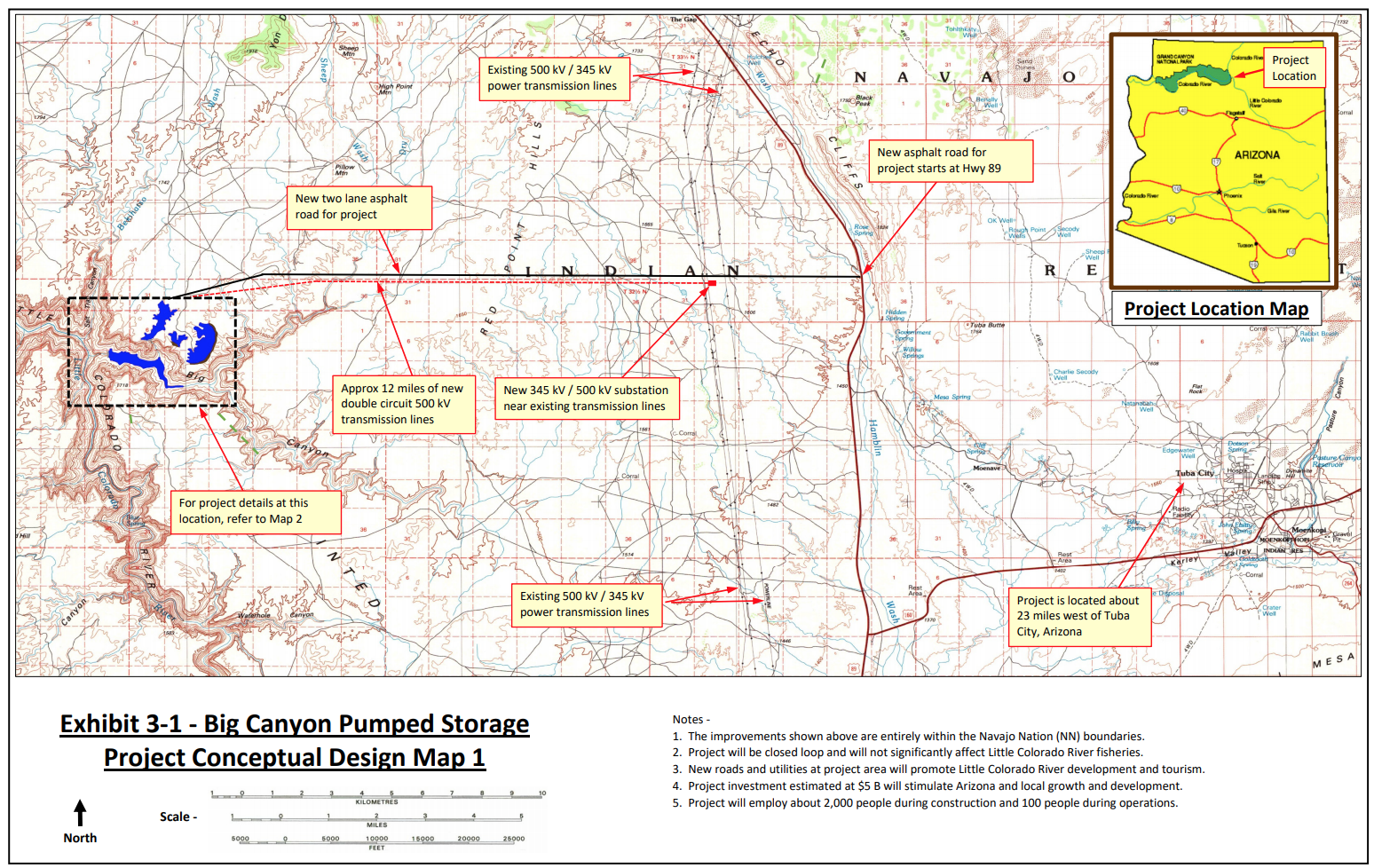
The need to remedy this oversight became even more apparent in 2020, after preliminary permits were issued for two pumped storage hydropower projects on the lower Little Colorado River not far from its confluence with the Colorado River in the Grand Canyon and within the sovereign borders of the Navajo Nation despite objections by the Navajo Nation, the Hopi Tribe, and the Hualapai Tribe. A third proposal to dam nearby Big Canyon for hydropower has been pending since 2020.
Update: On April 25, 2024, the Federal Energy Regulatory Commission struck down the proposed Big Canyon Dam. Read more ›
Following several years of community conversations on the Navajo Nation and in Hopi villages, and informed by the concerns community members voiced, on February 6, 2024, the Hopi Tribe passed Resolution 010-2024 in which the Hopi Tribal Council resolved to petition the Federal Energy Regulatory Commission to update its rules to require tribal consultation and consent for granting preliminary permits for hydroelectric projects on tribal lands.
In these orders, the commission announced a new policy: “the Commission will not issue preliminary permits for projects… if the Tribe on whose lands the project is to be located opposes the permit.”
The commission didn’t immediately strike down the Big Canyon project, but instead opened an additional 30-day comment period, likely intended to provide the Navajo Nation an opportunity to make a clear statement about whether or not it opposes the project.
The Hopi Tribe is currently reviewing the Federal Energy Regulatory Commission’s new policy on tribal consent and speaking with other tribes as potential cosigners on a formal petition urging the commission to establish additional requirements governing tribal consultation and consent before preliminary permits can be issued on tribal lands. Regardless, this recent reversal in policy, at the very least, stands in recognition of tribal sovereignty, grants tribes a legal means of determining the kinds of hydropower projects that happen on their lands, and is a positive, proactive step toward true self-determination and governance for Native people.
Daryn Akei Melvin works as a Grand Canyon manager for the Grand Canyon Trust with a focus on addressing issues related to the Little Colorado River.
EDITOR’S NOTE: The views expressed by Advocate contributors are solely their own and do not necessarily represent the views of the Grand Canyon Trust.
Representatives from the U.S. Environmental Protection Agency met with Cove community members last week to discuss the agency’s decision to place the Lukachukai Mountains Mining District on the National Priorities List. Although the meeting was intended to be informational, tribal, Navajo EPA and community leaders expressed their uncertainty about whether the federal government will actually start addressing the cleanup of the abandoned uranium mines that landed the site on the EPA list, also known as the Superfund program. The mining district encompasses Navajo Nation communities of Cove, Round Rock and Lukachukai in the far northeastern corner of Arizona.
“We are looking at what happened in the past and how the federal government could have prevented a lot of this contamination,” said Council Delegate Amber Kanazbah Crotty, “could’ve prevented our community from getting sick. What I don’t want them (children) to have to deal with is another three or four decades before actual action happens.”
[…]
Phil Harrison remembers when his childhood community of Cove was alive with family gatherings, ceremonies, rodeos, farming and ranching, but after decades of uranium contamination, those days are a thing of the past…Harrison’s father was a miner in the uranium mines of Cove, which was where uranium was first discovered on the Navajo Nation. Uranium production in the northern and western Carrizo Mountains of the Navajo Nation began in 1948, peaked in 1955 and 1956 and declined to zero again by 1967.
Confluence of the Little Colorado River and the Colorado River. Climate change is affecting western streams by diminishing snowpack and accelerating evaporation. The Colorado River’s flows and reservoirs are being impacted by climate change, and environmental groups are concerned about the status of the native fish in the river. Photo credit: DMY at Hebrew Wikipedia [Public domain]
For the past 60 years, Navajo leaders have worked to settle water claims in Arizona. The aim of the Northeastern Arizona Indian Water Rights Settlement Agreement is to affirm and quantify the nation’s rights to water in the state and to secure funding to build much needed water delivery infrastructure to homes on the Navajo Nation, according to a summary of the agreement.
“When we took office last year there was a huge push for us to start talking about our water rights, our water claims,” Navajo Nation Speaker Crystalyne Curley told The Arizona Republic. “It’s been far too long, going through COVID, climate change, drought that we are facing every year, we had to take into account of what we want to secure for the next 100 years.”
The U.S. Supreme Court held last summer that the United States did not have an affirmative treaty or trust obligation to identify and account for Navajo Nation water rights on the Colorado River. Curley said that ruling was a pivotal moment that led the Navajo Nation and its water rights negotiation team to focus on completing on the settlement…
The Coconino Aquifer. The fundamental law of the Navajo (Dine) people believes water to be one of the four sacred elements that was put forth by Diyin dine’e’ (Deities) as a source of life. Water is part of prayer in the Hozho ceremonies for healing. All human and all life on Nahasdzaan (Mother Earth) have a degree of water in their system. Water is precious to native people – it is life. Credit: Dine’e’ C.A.R.E.
The agreement will settle all of the Navajo Nation, Hopi Tribe and San Juan Southern Paiute water rights for the upper and lower basins of the Colorado River, the Little Colorado River basin, the Gila River Basin (including Big Boquillas Ranch) and claims to groundwater in the Navajo Aquifer, the Coconino Aquifer and other alluvial aquifers.
Confluence of the Little Colorado River and Colorado River; Credit: EcoFlight
Click the link to read the article on the Associated Press website (Felicia Fonseca and Suman Naishadham). Here’s an excerpt:
February 28, 2024
A Native American tribe with one of the largest outstanding claims to water in the Colorado River basin is closing in on a settlement with more than a dozen parties, putting it on a path to piping water to tens of thousands of tribal members in Arizona who still live without it. Negotiating terms outlined late Wednesday include water rights not only for the Navajo Nation but the neighboring Hopi and San Juan Southern Paiute tribes in the northeastern corner of the state. The water would come from a mix of sources: the Colorado River that serves seven western states, the Little Colorado River, and aquifers and washes on tribal lands. The agreement is decades in the making and would allow the tribes to avoid further litigation and court proceedings, which have been costly. Navajo officials said they expect to finalize the terms in the coming days. From there, it must be approved by the tribe’s governing bodies, the state of Arizona, the other parties and by Congress…
On Wednesday, the Navajo Nation cited climate change, cost, competition for water and the coronavirus pandemic as reasons to move toward a settlement. Arizona, in turn, would benefit by having certainty over the amount of water that is available to non-tribal users. The state has had to cut its use of Colorado River water in recent years because of drought and demand…
Arizona — situated in the Colorado River’s Lower Basin with California, Nevada and Mexico — is unique in that it also has an allocation in the Upper Basin. Under the settlement terms, Navajo and Hopi would get about 47,000 acre-feet in the Upper Basin — nearly the entire amount that was set aside for use at the Navajo Generating Station, a coal-fired power plant on the Navajo reservation that shut down in late 2019. The proposal also includes about 9,500 acre-feet per year of lower-priority water from the Lower Basin for both tribes. An acre-foot of water is roughly enough to serve two to three U.S. households annually. While the specific terms for the San Juan Southern Paiute Tribe remain under discussion, Congress could be asked to establish a small reservation for the tribe whose ancestral land lies in Utah and Arizona. The tribe’s president, Robbin Preston Jr., didn’t immediately respond to emailed questions from the AP.
Native America in the Colorado River Basin. Credit: USBR
The Supreme Court on Friday agreed to hear a dispute between the Navajo Nation, the Biden administration and three states over the increasingly important question of whether the tribe has the right to draw water from the Colorado River. The justices will hear two appeals — one brought by the federal government and another by the states of Arizona, Nevada and Colorado in addition to several California water districts — that arise from the Navajo Nation’s efforts to assert rights to the river that flows alongside the reservation’s northwestern border. The tribe’s land, the largest Native American reservation, is mostly in Arizona but also crosses into New Mexico and Utah.
The Biden administration and the three states appealed after the San Francisco-based 9th U.S. Circuit Court of Appeals ruled in favor of the Navajo Nation in February, saying it could sue the government for an alleged failure to carry out its duties on behalf of the tribe. The dispute is over whether the government had a legal duty that the tribe can enforce in court. The tribe, which first signed a treaty with the United States in 1849, argues that under its agreements with the federal government that assured it would have access to land, it was assumed that the government also has a duty to provide necessary water.
The Little Colorado River is best known for its milky blue waters that flow into the mainstem Colorado River in the Grand Canyon. These waters carry so much life-giving significance. For millennia, they have provided physical and spiritual sustenance for Indigenous peoples and supported plants, wildlife, communities, and more.
Grand Falls Little Colorado River, Spring of 2010.
But the Little Colorado River is not always blue. Sometimes it runs as thick and brown as chocolate milk. With a little knowledge of the river’s annual peaks and lows and an eye on the weather gauge, you can predict whether it will be brown or that remarkable turquoise blue.
So why and when is the Little Colorado River so blue?
Confluence of the Little Colorado River and the Colorado River. Climate change is affecting western streams by diminishing snowpack and accelerating evaporation. The Colorado River’s flows and reservoirs are being impacted by climate change, and environmental groups are concerned about the status of the native fish in the river. Photo credit: DMY at Hebrew Wikipedia [Public domain]
The source of its milky blue waters
The Little Colorado River gets its blue color from dissolved calcium carbonate in the water. This mineral is found in chalk, antacids, eggshells, dark green vegetables, rocks, and more. In the Little Colorado River, calcium carbonate forms a type of limestone called travertine that creates white, pillowy deposits along the riverbed. Most of the turquoise-blue water in the Little Colorado River comes from springs 10 to 13 miles upstream of the confluence. Thanks to these groundwater-fed springs, the last 13 miles of the Little Colorado River flow year-round at an average rate of 220 cubic feet per second (cfs) until joining the mighty Colorado River, which has an average flow between 8,000 and 25,000 cfs!
The Little Colorado River’s year-round flows are important for the region’s largest population of humpback chub. The warm, cloudy waters make excellent habitat for this threatened fish species.
Little Colorado River. Photo credit: Sinjin Eberle via American Rivers
Other colors of the Little Colorado River
When the Little Colorado River begins its journey from its headwaters in the White Mountains, its waters are not yet blue. The clear mountain stream flows north into the desert lands below, picking up sediment, minerals, and debris along the way. But less than 20 miles from its source, the Little Colorado River dries up. And for the next 300 miles, the river relies on precipitation to send water downstream. Modern-day water use is a major culprit of this dry stretch of the Little Colorado River. Year-round flows return near Blue Spring, 13 miles upstream of the confluence.
During two high runoff periods each year — in the spring from snowmelt and in the late summer from monsoon rains — the Little Colorado River runs red. During these periods, from February to April and July to September, the Little Colorado River may spike to 18,000 cfs. At this runoff level, the water can be so thick and muddy that placing your hand just an inch below the surface of the water makes it invisible to the naked eye.
The cultural significance of the Little Colorado River’s blue waters
The Little Colorado River’s blue waters have been of deep cultural significance to Native peoples since time immemorial. At least 10 tribes have traditional connections to what Zuni people refer to as “the umbilical cord” of the world. For Hopi people, the Little Colorado River is the home of their emergence story, and its waters, springs, and salt remain important to this day. Adjacent Diné (Navajo) communities, whose land may be affected by proposed dam development, are considering a sacred site designation for the area to prevent development threats like the former Escalade tram proposal.
But to truly understand the importance of the Little Colorado River, I suggest you go directly to the source. Visit the Lifeways of the Little Colorado River collection to hear 11 Native voices share their personal and cultural ties to this life-sustaining river.
It’s late fall 2021 and I’m at the Tuba City Chapter House on the Navajo Nation for one of several community meetings that American Rivers, the Grand Canyon Trust, and local communities are hosting to explore ways to safeguard and sustain the Little Colorado River. The air is crisp and the sun peeks above the eastern horizon as we set up an outdoor meeting space designed to respect necessary Covid-19 precautions. Because this type of grassroots organizing has been nearly impossible for over a year, there is a tangible feeling of excitement as people gather to engage in conversations about this lifegiving watershed that supports much of present-day northern Arizona.
Little Colorado River community outreach meeting at the Tuba City Chapter House on the Navajo Nation; Credit: Mike Fiebig
The Little Colorado River (LCR) is essentially a misnomer—“little” only in title and by comparison to the Colorado River. The LCR basin is 27,000 square miles of high deserts, mesas, and mountains near the center of the Colorado Plateau. Its grandeur can be understood from various angles. As part of the larger Colorado Plateau, the LCR basin has the highest agricultural and ethnolinguistic diversity north of the Tropic of Cancer. The river itself originates in the White Mountains where its headwater springs have been designated as a sacred site by the White Mountain Apache Tribe. From there, the river drops over 5,000 feet as it flows northwest to its Confluence with the Colorado River deep within Grand Canyon. As it nears the mainstem Colorado, the LCR cuts steeply into limestone and sandstone, creating the spectacular lower LCR gorge. Springs in the lower gorge provide the cerulean baseflow of the LCR, which at the Confluence with the Colorado is approximately 158,000 acre feet annually—equivalent to over half of Nevada’s allocation of Colorado River water.
Lower Little Colorado River Gorge; Credit: EcoFlight
With monsoon and spring runoff events, the LCR can swell to over 400 times its baseflow. The river is a primary contributor of sediment to the Grand Canyon and critical habitat for the threatened humpback chub. In truth, the cultural and ecological significance of the LCR and its watershed is difficult to overstate. It is the ancestral or present-day homelands of at least eight tribes, including Hopi, Zuni, Diné, Southern Paiute, Cibecue and White Mountain Apache, Havasupai, and Hualapai, each of whom have maintained relationships with the LCR since time immemorial.
The uniqueness of this high desert river and watershed is also demonstrated by its resilience. Until the early 20th century, the LCR flowed year-round for its entire 340-mile course. It is now intermittent except for three short stretches. Sixty years of industrial groundwater withdrawal has impacted aquifers critical to springs, tributaries, and drinking water in an increasingly arid region. The Grand Canyon Escalade project proposed a massive tourist attraction at the remote and sacred Confluence of the LCR and Colorado River, which led American Rivers to list the Colorado River in the Grand Canyon as America’s Most Endangered River in 2015. Coal-fired generating stations polluted the air and drove strip mining in the basin. Uranium mining and milling contaminated water sources and continues to impact human, animal, and plant health.
Now, hydroelectric dam proposals threaten the lower LCR. With total disregard for tribal sovereignty, Pumped Hydro Storage LLC applied for three preliminary permits in 2019 and 2020 from the Federal Energy Regulatory Commission (FERC) to dam the LCR and its tributaries. While two of the permits have been surrendered, the company is awaiting a preliminary permit for the Big Canyon project. Despite objection from the Navajo Nation and Hopi Tribe, the Big Canyon project proposes four dams and four reservoirs that would be filled with groundwater from the same aquifer that sustains the sacred springs and iconic milky-blue waters of the lower LCR.
Little Colorado River near the Confluence; Credit: Sinjin Eberle
The concentrated harm to the LCR caused by colonization, coupled with the ongoing uncertainty of what threat will have to be fought off next, makes the LCR a poster child for environmental injustice. But the river and LCR communities persist. Save the Confluence stopped the Grand Canyon Escalade and continues to advocate for the Confluence as a sacred area. Black Mesa Trust advocates for the ancient aquifers in the LCR basin and their related springs that are central to Hopi religion. Tó Nizhóní Ání protects the sacred lands and waters of Black Mesa, a central recharge area for the LCR. And Tolani Lake Enterprises rebuilds the Indigenous food sovereignty movement on the banks of the LCR.
Such grassroots efforts hold the barrage of threats to the LCR at bay while also highlighting the need for durable and permanent protections for this remarkable river and the life it supports. Building on our previous work in the basin, in the Spring of 2020 American Rivers joined LCR communities and allies, like the Grand Canyon Trust, to explore ways to safeguard the river’s cultural and natural resources—with particular focus on the lower LCR—in ways that align with the needs and wants of local communities. For a year and a half, we’ve been working collaboratively to identify pathways to protect the LCR while upholding local autonomy and traditional land uses. This includes preventing commercial and industrial developments in the area, such as the Big Canyon proposal, that are unwanted by local communities. Our guiding belief is that thoughtful community engagement and collective management approaches can help protect the lower LCR, surrounding sacred sites, and all living beings for years to come. By engaging individual community members through in-depth conversations, hosting in-person and virtual community meetings, and providing information on possible protective pathways, we are collaborators in a growing movement to protect the LCR. Looking ahead, we are committed to supporting this movement through expanded community engagement and leadership until permanently protecting the LCR simply becomes inevitable.
LCR advisor, Larry Foster, discussing options for safeguarding the LCR; Credit: Amanda Podmore
As I drive away from the meeting in Tuba City, I am reminded that despite overuse, unregulated groundwater withdrawal, impacts from industrial energy production, and the increasing effects of climate change, the LCR is alive. It is sustained as much by monsoons, ancient groundwater, and high elevation snow as it is by the collective stories, ceremonies, and traditions of its Indigenous communities. Often described as an umbilical cord, the LCR is a literal lifeway in the region and, as such, it deserves more than simply being resilient. It deserves to thrive.
Confluence of the Little Colorado River and the Colorado River. Climate change is affecting western streams by diminishing snowpack and accelerating evaporation. The Colorado River’s flows and reservoirs are being impacted by climate change, and environmental groups are concerned about the status of the native fish in the river. Photo credit: DMY at Hebrew Wikipedia [Public domain]
Good news! After two years of tireless advocacy led by the Navajo Nation, Hopi Tribe, and Hualapai Tribe, a would-be hydroelectric dam developer has requested the cancellation of two preliminary permits for dams on the lower Little Colorado River above the confluence with the Colorado River inside the Grand Canyon.
Pumped Hydro Storage LLC sent two letters to the Federal Energy Regulatory Commission (FERC) requesting the permits for its Little Colorado River and Salt Trail Canyon proposals be surrendered, citing strong opposition from the Navajo Nation, environmentalists, and others, as well as investment risks. This news comes two years after the developer first proposed the projects on Navajo Nation land in a region of deep cultural importance to many tribes.
Developer failed to work with tribes
Despite community opposition to the two dam proposals and interventions and objections from the Navajo Nation, the Hopi Tribe, and the Hualapai Tribe, Native organizations like Save the Confluence, and conservation organizations including the Grand Canyon Trust, FERC awarded preliminary permits for both the Little Colorado River and Salt Trail Canyon dam proposals. The developer was not required to get consent from the Navajo Nation or even consult with tribes, underscoring deep flaws in the permitting process. The company’s decision to surrender the permits for these two projects is a testament to the hard work of tribes, community organizers, and concerned citizens like you who took action and submitted comments. Thank you.
A river too fragile for dams
Had these hydroelectric dam proposals moved forward, the consequences on this arid landscape would have been severe. The lower Little Colorado River flows perennially into the Colorado River in the Grand Canyon, and its warm turquoise-blue waters shelter the endangered humpback chub when it is spawning.
The lower Little Colorado River is a spiritual place best left untouched by development, as grassroots community members and tribes have requested. It is home to the Hopi place of emergence along with innumerable other cultural sites. Upstream dams could alter this place of reverence and beauty.
Two down, one more dam to go
Map credit: The Grand Canyon Trust
Unfortunately, the developer’s request to surrender these two permits is a reminder of the work ahead. The developer is still waiting to hear back on a preliminary permit for the Big Canyon dam proposal on a tributary to the Little Colorado River. The Big Canyon dam remains the developer’s priority — and our biggest concern. The Big Canyon dam proposal, which is also on Navajo Nation land and opposed by many tribes, would require pumping groundwater and likely alter the blue waters of the Little Colorado River.
West Drought Monitor map July 27, 2021.
Drought underlines the imprudence of the Big Canyon dam
The developer is proposing to pump about 44,000 acre feet (about 14.3 billion gallons) of groundwater, plus an additional 10,000 to 15,000 acre feet (3.2 to 4.8 billion gallons) per year to make up for water lost to evaporation in order to fill the Big Canyon dam in an arid landscape already facing extreme drought and water restrictions. Currently, there are potable water restrictions across the Navajo Nation. It is alarming that the developer is continuing to push a proposal to pump additional groundwater to power this project in order to produce electricity for distant city centers in the middle of this drought.
It is unknown when FERC will make a decision on the Big Canyon dam proposal’s preliminary permit application, which, if granted, would initiate a 3-year period for a feasibility study. What we do know is we will continue to stand with local communities and fight this unwanted and inappropriate proposal tooth and nail. If you haven’t already, please sign the petition to Keep the Canyon Grand and join our action alert network. We’ll let you know when there’s an opportunity to speak up.
Confluence of the Little Colorado River and the Colorado River. Climate change is affecting western streams by diminishing snowpack and accelerating evaporation. The Colorado River’s flows and reservoirs are being impacted by climate change, and environmental groups are concerned about the status of the native fish in the river. Photo credit: DMY at Hebrew Wikipedia [Public domain]
The Confluence. Photo credit: From the Earth Studio
Spider Grandmother’s presence along the Little Colorado River. Photo credit: From the Earth Studio
The turquoise waters of the Little Colorado River. Photo credit: Lyle Balequah/From the Earth Studio
Little Colorado River. Photo credit: Sinjin Eberle via American Rivers
Little Colorado River Upstream towards Big Canyons. Photo credit: Sinjin Eberle
NPS and USFWS use a seine net to trap humpback chubs in the Little Colorado River. Photo credit Mike Pillow via the Arizona Daily Sun.
The $1 billion Navajo-Gallup water pipeline will take 12 years to build and could serve as many as 250,000 people a year by 2040, officials say. Image via Cronkite News.
Historically Navajos have lived off the land. But decades of assimilation, forced relocation and dependence on federal food distribution programs changed that.
Navajo farmer Tyrone Thompson is on a mission to help people return to their roots. He’s even taken to social media to teach traditional farming techniques.
In a recent video he demonstrates how to layer organic matter to turn dry clay into rich fertile soil.
The U.S. Department of Agriculture calls the Navajo Nation a food desert. People travel up to 40 miles to get their groceries. But Thompson says they don’t have to.
“As we see the shelves emptying of food and toilet paper we kind of reconnect to our roots,” Thompson says. “Some of the tools that were given by our elders and our ancestors — our planting stick and our steering sticks — those are our weapons against hunger and poverty and sickness.”
The Navajo Nation filed a lawsuit on Monday against the U.S. EPA and the U.S. Army Corps of Engineers in the U.S. District Court for the District of New Mexico, arguing that the recent 2020 Waters of the United States rule significantly diminishes the number and extent of Navajo waters protected by the Clean Water Act in violation of the Administrative Procedure Act. The new rule could also adversely impact the amount of federal funding that the Navajo Nation Environmental Protection Agency receives for its water programs.
“At this point in time, with climate change occurring around the world, it’s more prudent than ever to protect our land, water and air. We, as Diné People, have a duty to preserve and conserve our natural resources to ensure that our future generations have access to clean water, air and land. The previous 2015 Waters of the United States rule provided clarity in protecting our Nation’s waters. Therefore, we strongly oppose and disagree with the revised WOTUS,” said President Nez.
The Nez-Lizer Administration is proposing to use $300 million from the CARES Act funding that the Navajo Nation received for water infrastructure and agriculture projects, which will require clean water resources to development and construct.
“Our Navajo people always say that water is life, and that’s very true. When we plan for any type of water projects, we are planning for future generations, not just for today or tomorrow. Clean water is a necessity for life,” said Vice President Myron Lizer.
“Clean water should be protected not only by the Clean Water Act, but also by the Navajo Nation’s treaty rights. It is a necessity of life that is vital to preservation of Navajo culture and tradition,” added Navajo Nation Attorney General Doreen N. McPaul.
Department Manager for Navajo Nation Environmental Protection Agency’s water programs Ronnie Ben said, “Since the inception of the Navajo Nation Environmental Protection Agency’s water programs, our main purpose and goal has always been to protect our Nation’s water sources. However, our job becomes difficult when the federal government rolls back environmental regulations in favor of polluters. We currently have organizations on the Navajo Nation who are not in compliance with Navajo Nation and Federal environmental laws and laxing Waters of the United States doesn’t help bring these companies into compliance.”
President Nez and Vice President Lizer thank Navajo Nation Attorney General Doreen N. McPaul, Navajo Nation Department of Justice Attorney Michael Daughtry, Contract Attorney Jill Grant, and Navajo Nation Environmental Protection Agency water program personnel for their efforts in bringing this suit on behalf of the Navajo people.
Utah Rivers map via Geology.com
New Mexico Lakes, Rivers and Water Resources via Geology.com.
We will intervene, again, in the FERC preliminary permit process, but you can help too.
Little Colorado River Upstream towards Big Canyons. Photo credit: Sinjin Eberle
As we wrote in October, a Phoenix-based developer has proposed to build a pumped hydropower facility on and above the Little Colorado River in Arizona, one of the major tributaries to the Colorado River in the Grand Canyon. Because this is an energy-related project, the Federal Energy Regulatory Commission (FERC) is the federal agency that would permit the project. The developer, Pumped Hydro Storage, LLC, actually applied for preliminary permits for two complete projects within the canyon, holding their place in line for two possible locations in the same area.
In November, we filed our comments with FERC, opposing the projects on a number of grounds. First and foremost, the idea of building new dams, reservoirs, and other related infrastructure (imagine the pipes, wires, roads, and other structures needed for such a facility) on such a major tributary of the Colorado River would be a destructive, resource intensive, and in all likelihood, impossible, endeavor. Secondly, the facilities would be situated firmly within the Navajo Nation, on Navajo land – yet the Navajo were barely even consulted on the project prior to the permit applications being submitted to FERC, and have since come out strongly against the projects being built on their lands, and very close to one of the most significant cultural sites to the Hopi as well. Lastly, the Little Colorado River is home to a major humpback chub recovery project, a fish on the brink of being down-listed from Endangered to Threatened due to the success of the program.
Including from American Rivers, the proposal generated a wide body of opposition from sources who don’t often speak out against projects like this, such as the Bureau of Reclamation and Department of Interior, multiple Tribal Nations and the two local Navajo Chapters in the area, multiple conservation groups, and even Arizona’s Department of Game and Fish. Basically, nobody outside of the developer feels that these projects are warranted, or even a very good idea, let alone feasible.
Big Canyon Pumped Hydro Project #15024-000 | Credit: FERC permit application via American Rivers
Now, Pumped Hydro Storage has applied for a new project with FERC (Permit 15024-000), which would be located not within the Little Colorado River, but in Big Canyon, a tributary to the Little Colorado about 23 miles west of Tuba City, Arizona. Unlike the original proposal, in this new one Pumped Hydro Storage is proposing to extract groundwater, bring it to the surface where it would rest in three different surface reservoirs, and build a fourth, lower reservoir and a variety of pipes and penstocks and other infrastructure to generate electricity. Here is how it is described in the permit application:
The proposed project would be located entirely on Navajo Nation land and consist of the following new facilities:
A 450-foot-long, 200-foot-high concrete arch dam (Upper West Dam)
A 1,000-foot-long, 150-foot-high earth filled dam (Middle Dam)
A 10,000-foot-long, 200-foot-high concrete arch dam (Upper East Dam)
each of which would impound three separate upper reservoirs with a combined surface area of 400 acres and a total storage capacity of 29,000 acre-feet of water
A 600-foot-long, 400-foot-high concrete arch dam (Lower Dam) that would impound a lower reservoir with a surface area of 260 acres and a total storage capacity of 44,000 acre-feet of water
Three 10,000-foot-long, 30-foot-diameter reinforced concrete penstocks;
An 1,100-foot-long, 160-foot-wide, 140-foot-high reinforced concrete powerhouse housing nine 400-kilowatt pump-turbine generators
And a whole lot more associated infrastructure, including a new 15-mile paved road, powerlines, a 30-ft diameter tunnel, and more.
Map Credit: Stephanie Smith, Grand Canyon Trust
Finally, an additional twist, as reported in a recent Associated Press article, the developer concedes that there was overwhelming opposition to his original proposal, and that he would consider pulling the proposals in the Little Colorado River if this Big Canyon proposal were allowed to move forward. From the article:
The article then goes on to say:
Many of the reasons that Pumped Hydro Storage, LLC’s initial proposal shouldn’t move forward apply to this new proposal as well; namely that the project would be built on Navajo Nation lands, and neither the local Chapter, nor the Navajo Nation government, have given their permission to construct the project on their lands. Second, the idea of pumping significant volumes of groundwater from one of the most arid regions of the country to profit from cheap electricity is misguided, at best. And just like the first round of proposals, destruction of significant Hopi holy sites, as well as threatening critical humpback chub and other fish habitat, through the massive extraction of local groundwater, is simply not acceptable.
In addition to how environmentally destructive and wasteful these projects are, this proposal is especially tone-deaf and exploitive at this moment in our history. The Navajo Nation is grappling with some of the highest number of cases, and deaths per capita, from the novel Coronavirus pandemic. One of the reasons why the outbreak has impacted the Navajo so heavily is the lack of readily available clean water. In fact, in the western Navajo Nation, the lack of basic infrastructure to deliver water to people’s homes is sorely lacking, and most of the people in that area have to haul water themselves many miles to have any at all. The idea of building expansive infrastructure to extract scarce groundwater for a hydropower project that extracts the resource and the capital from it, when people around the project who lack that access to that very resource are working hard to defend their communities against a deadly virus, could not be more misguided.
It is important to understand that a preliminary permit only allows the developer to hold a location for a potential future proposal. It is not a license application. In fact, a preliminary permit is not even required to submit a license application or receive a Federal Energy Regulatory Commission (FERC) hydropower license. To learn more about hydropower licensing, visit the Hydropower Reform Coalition’s website.
We will intervene, again, in the FERC preliminary permit process, but you too can help by taking action here.
While it is unlikely that this project will ever advance past this phase, proposals like this underscore the importance of permanently protecting our last, best rivers like the Little Colorado.
Little Colorado River. Photo credit: Sinjin Eberle via American Rivers


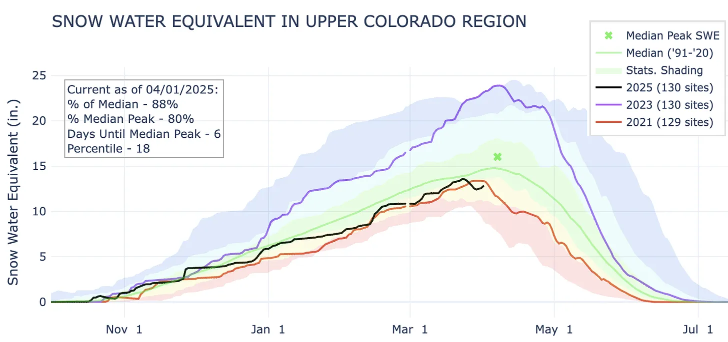
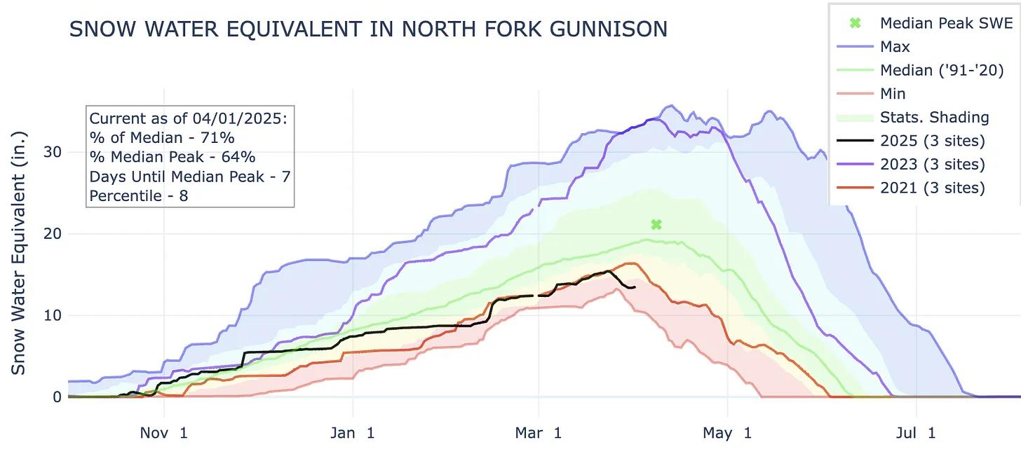


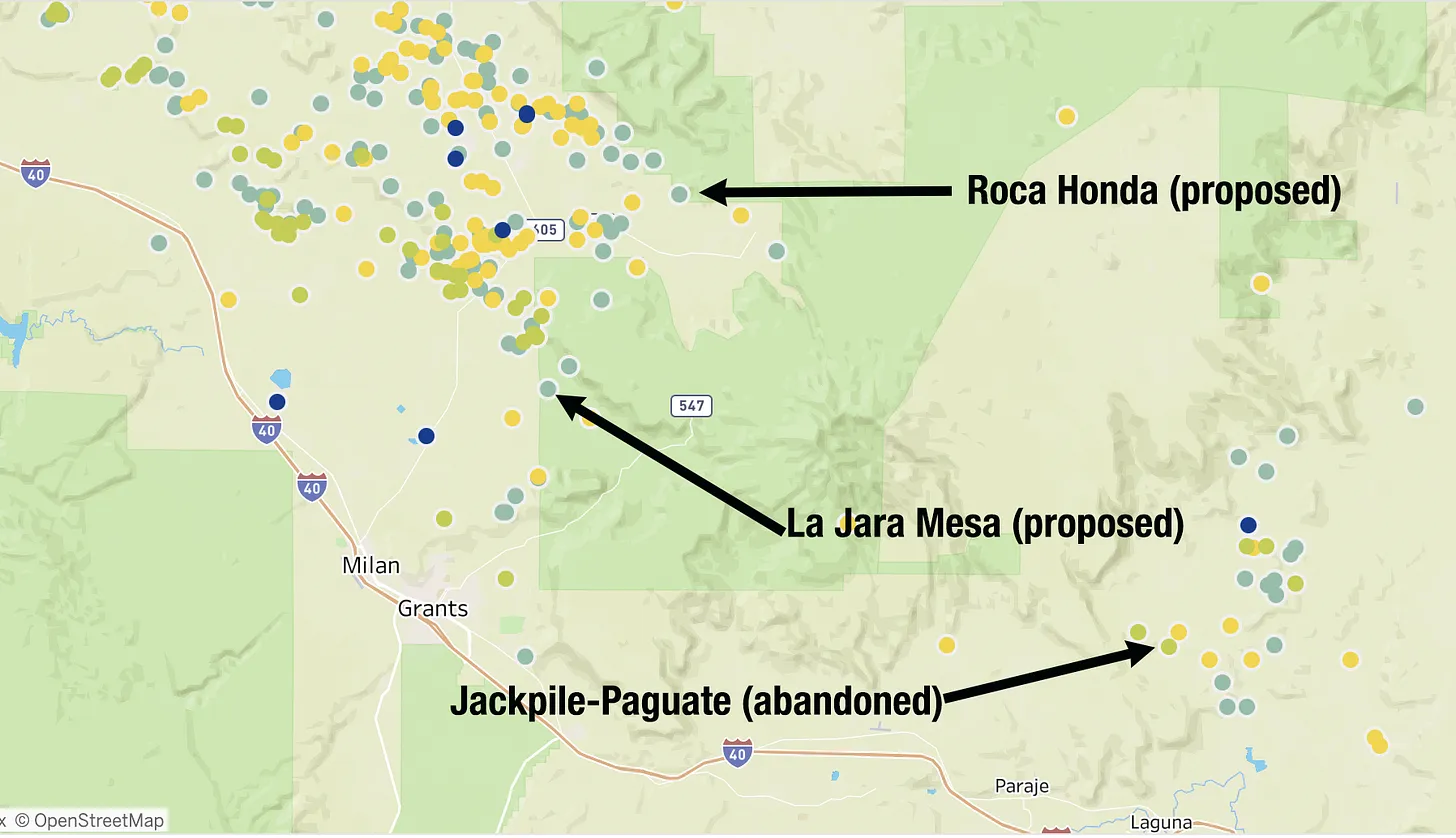


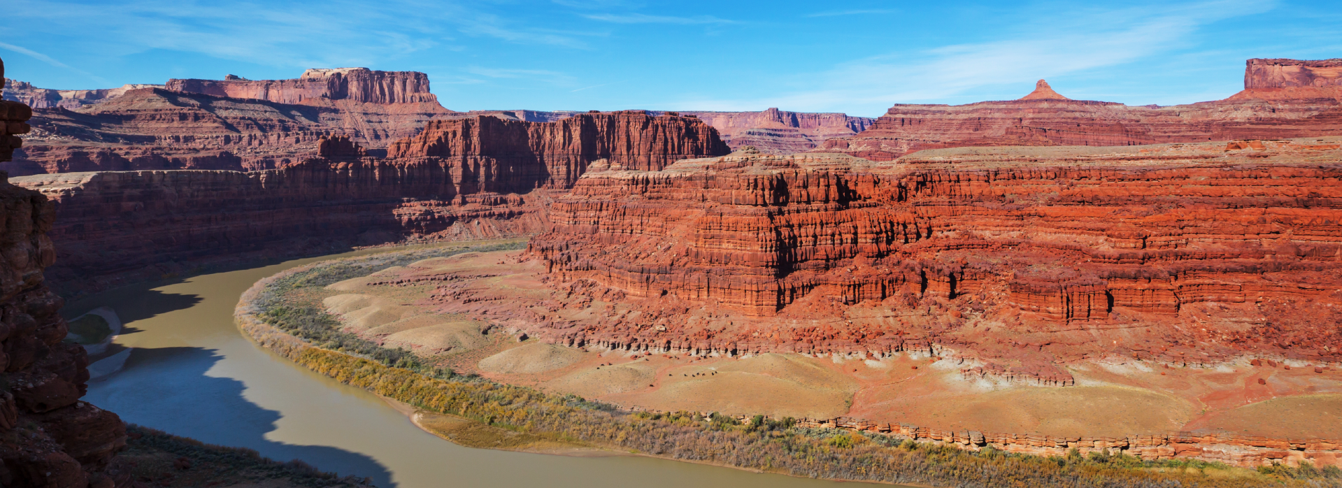


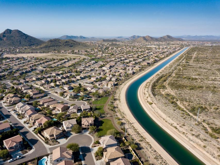


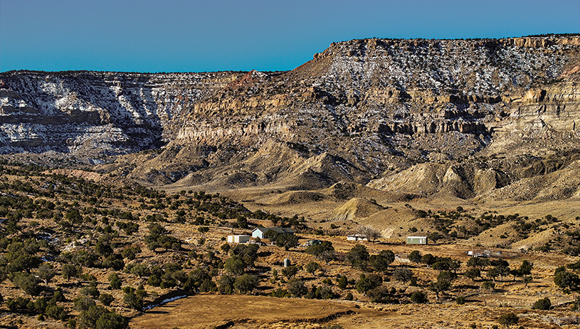


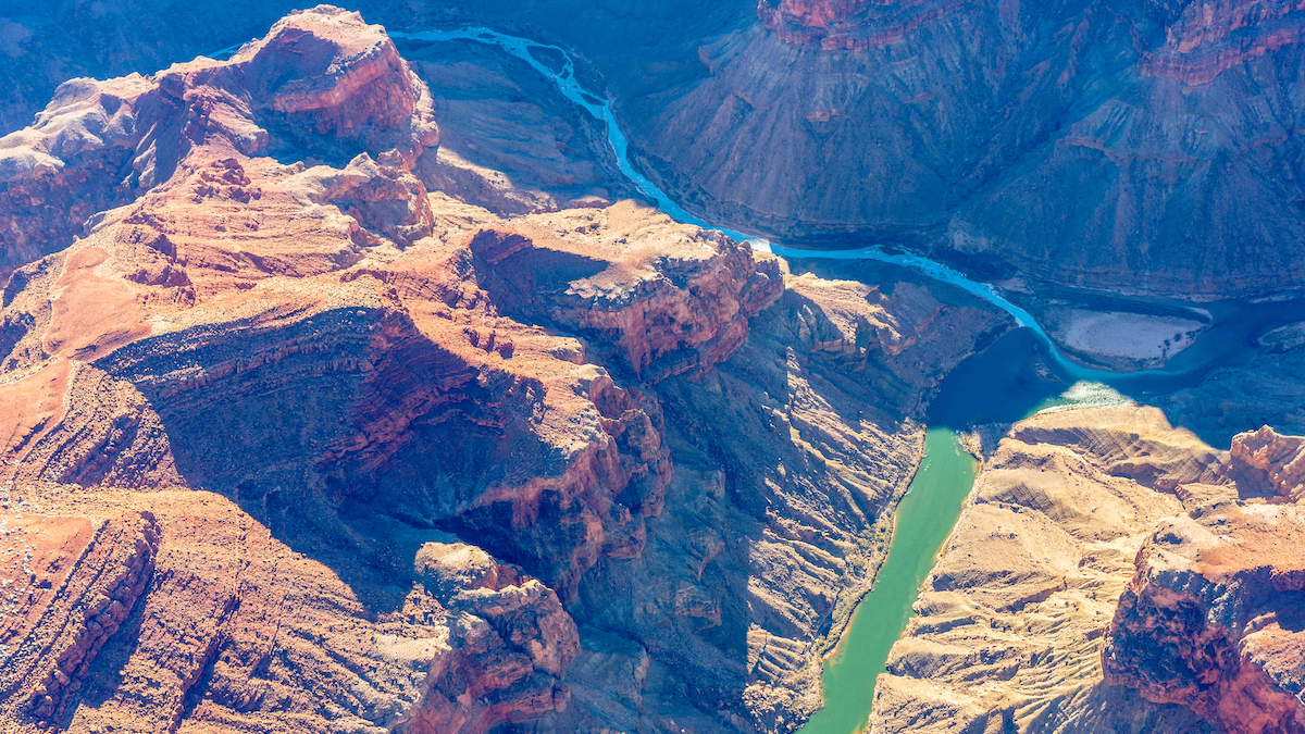

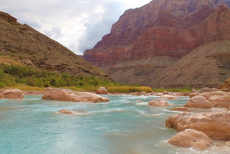


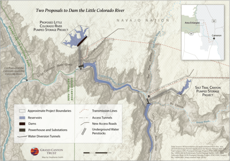
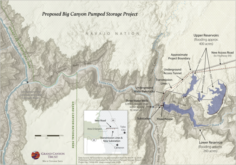
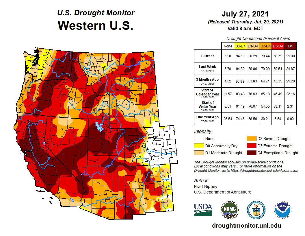
![Confluence of the Little Colorado River and the Colorado River. Climate change is affecting western streams by diminishing snowpack and accelerating evaporation. The Colorado River’s flows and reservoirs are being impacted by climate change, and environmental groups are concerned about the status of the native fish in the river. Photo credit: DMY at Hebrew Wikipedia [Public domain]](https://i0.wp.com/coyotegulch.blog/wp-content/uploads/2019/11/1024px-usa_little_colorado__colorado_rivers.jpg?w=558&h=376&ssl=1 "1024px-USA_Little_Colorado_&_Colorado_Rivers")