Why wind & solar power won’t easily replace the energy being produced by the Glen Canyon Powerplant

Aerial view of a large concrete dam with water flowing below, surrounded by red rock formations.
Photo of South Lake Powell and Glen Canyon Dam provided by The Water Desk. Photo by Alexander Heilner. Aerial support from LightHawk

by Robert Marcos

The electrical power that’s being produced by new wind and solar farms cannot fully replace the power being lost as the output of the Glen Canyon Powerplant continues to fall.

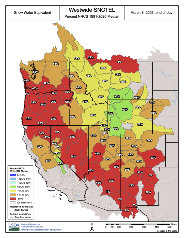
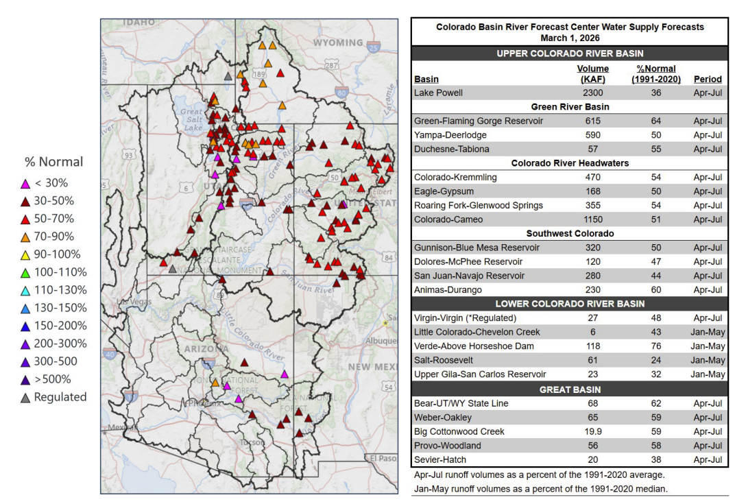
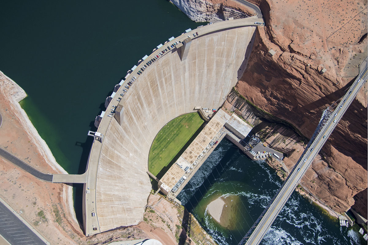
As of March 11, 2026, the Powerplant is producing only 60% to 65% of its maximum output. At full capacity the plant can produce 1,320 megawatts. But because of Lake Powell’s low water level it’s currently producing between 800 and 870 megawatts. While new wind and solar power will cushion the impact of Glen Canyon’s decline, the hydroelectric power is a critical component of the regional power grid. Electricity from the Glen Canyon Powerplant is operationally superior to wind and solar mainly because it is dispatchable, highly flexible, and provides critical grid‑stability services that variable renewables cannot provide on their own.

Dispatchability and reliability

Glen Canyon can generate on demand, ramping output up or down quickly to follow load; flows and generation are deliberately increased during weekday business hours to match demand.

Hydropower at Glen Canyon is not dependent on real‑time sun or wind conditions, so it can produce power at night, during calm periods, and in cloudy weather, as long as water is available in Lake Powell.

The plant provides both energy and dependable capacity for resource adequacy, which is essential during extreme heat waves and other system‑stress events when solar and wind output may not align with peak demand.

Flexibility and ramping

Glen Canyon is explicitly operated for load following: its turbines adjust automatic generation control signals to continuously balance supply and demand, so actual output can be above or below the hourly schedule at any moment.

The dam is allowed to fluctuate releases to provide about 40 MW of regulation capacity, with short‑lived flow changes of roughly 1,200 cfs up or down that help stabilize the grid against second‑to‑second and minute‑to‑minute imbalances.

Turbines can ramp thousands of cubic feet per second within an hour (subject to environmental constraints), providing fast ramping that complements slower, weather‑dependent changes in wind and solar output.

Grid‑stability and system services

Conventional hydropower units like those at Glen Canyon provide inertia, frequency regulation, spinning reserve, voltage support, and black‑start capability, all of which are necessary to keep the system stable as variable renewables grow.

These services are inherently available from large synchronous hydro generators without needing extensive additional power‑electronics‑based equipment that wind and solar typically require for similar functions.

Glen Canyon’s participation in automatic generation control helps maintain area control error near zero, directly supporting system frequency and reliability.

Scale, efficiency, and cost characteristics

Glen Canyon has a total capacity on the order of 1,300 MW and produces roughly 4–5 billion kWh per year, enough for hundreds of thousands of households across seven Western states.

Modern hydro units have high conversion efficiency and very long lifetimes (often 50–100 years), which spreads capital costs over decades and yields low long‑run levelized cost of electricity compared with many newer wind and solar plus storage builds.

Revenues from Glen Canyon hydropower also fund environmental and river‑management programs in Glen and Grand Canyons, a co‑benefit not typically associated with individual wind or solar plants.

As Colorado’s winter dries up, so do revenues for weather dependent businesses — #Colorado Public Radio

Clear Creek rafting via MyColoradoLife.com

Click the link to read the article on the Colorado Public Radio website (Haylee May). Here’s an excerpt:

February 16, 2026

The only thing snow shovels have been gathering recently is dust as Metro-Denver finds itself more than a foot behind its normal snowfall total this winter. Boulder National Weather Service Meteorologist, Russell Danielson, said the normal snow total through the end of January for metro-Denver is 27 inches. This year, just 13.4 inches fell. That’s a sharp drop from 2025, when the region saw 38 inches of snow over the same time frame. In the mountains, it’s even starker. Breckenridge typically sees 101.7 inches by the end of January. This year? Just 34 inches. The lack of snow has largely been framed as a ski industry problem. But across the Front Range and into Colorado’s river corridors, it’s become something broader — and more immediate. From car washes in southwest Denver to rafting guides scanning snowpack data in the high country, the dry winter is rewriting balance sheets in real time…For other weather-dependent businesses, the impact is far more dramatic.

“We calculated that we’re about 70% down,” said Amy Campbell, office manager for Bear Creek Tree Service in Englewood. In a typical winter, her crews plow at least every other week — sometimes multiple times depending on the storm…

West Drought Monitor map March 3, 2026.

The economic ripple from a dry winter won’t stop when the season changes. And that has small business owners who rely on summer tourism also worried. In Kremmling, co-owner of Downstream Adventures, Jonathan Snodgrass, is already watching the snowpack charts — not for ski conditions, but for river levels.

“I’m feeling a little worried,” he said. “If it stays on this track, we’re looking at not a lot of water to work with for rafting. That could have some big impacts on the duration of our season and the quality of our product.”

Rafting on Clear Creek and the upper Colorado River depends heavily on snowmelt. In low years like 2018, Clear Creek trips ended around the third weekend of July. In stronger years, they run into late August — sometimes up to Labor Day. Those final weeks are critical.

Westwide SNOTEL basin-filled map March 8, 2026.

A record warm winter could send #LakePowell to a historic low. Flaming Gorge may be its lifeline — The Salt Lake Tribune #GreenRiver #ColoradoRiver #COriver #aridification

A chart from the Colorado Basin River Forecast Center shows projected water supplies for the Colorado River basin compared to normal in 2026. (Provided by Colorado Basin River Forecast Center)

Click the link to read the article on The Salt Lake Tribune website (Brooke Larsen). Here’s an excerpt:

March 7, 2026

“Right now the hydrology that we have in front of us puts us in a very, very precarious situation,” said Gene Shawcroft, Utah’s Colorado River negotiator. Utah just wrapped up its warmest winter on record. Salt Lake City broke its previous maximum average winter temperature by 2 degrees Fahrenheit — a significant increase, according to the Colorado Basin River Forecast Center. While the state received similar precipitation compared to last year, much of that fell as rain, leading to the worst snowpack since 1981 in parts of the state. Now, the water supply outlook is “well below normal,” according to the center.  The Bureau of Reclamation’s latest most probable forecast for Lake Powell shows it sinking below “power pool” — 3,490 feet — by December. At that level, water can’t make it through the turbines at Glen Canyon Dam that generate hydropower and keep the lights on across Utah and six other states. Powell could hit that dangerous low even sooner, though. The bureau’s most recent forecast was based on the Colorado Basin River Forecast Center’s February report. Since then, the center’s projection for water flows into Powell has dropped by 100,000 acre-feet. The bureau’s most probable forecast can also be optimistic. The agency’s minimum probable forecast, which shows a dry scenario that would statistically happen only 10% of the time, sometimes aligns more with reality. Last year, the April 2025 minimum probable study forecasted Lake Powell to hit 3,535 feet in elevation by the end of February 2026. The lake currently sits at 3,530 feet. The bureau’s latest minimum probable forecast shows the lake dropping below 3,490 by the end of August. 

“It’s safe for us to assume that, unless Mother Nature is uncharacteristically generous, that Lake Powell elevations are going to fluctuate at elevations that we’re not comfortable with,” Wayne Pullan, Upper Colorado regional director for the bureau, said at a Glen Canyon Dam meeting last week…

To prop up Powell, the bureau will likely rely on another popular Utah reservoir: Flaming Gorge. The reservoir that straddles the border of Utah and Wyoming has the best water outlook in the basin, at 64% of normal, according to the forecast center. The Upper Green River, which flows into Flaming Gorge, is the “lone bright spot” for snow water equivalent — the amount of water snow holds…Under a 2019 plan, the bureau may form an agreement with Utah and the other states in the Upper Colorado River Basin — Colorado, New Mexico and Wyoming — to release water from Flaming Gorge and a few other reservoirs, such as Blue Mesa in Colorado, to maintain hydropower at Glen Canyon Dam.  That’s what happened the last time forecasts showed Powell dropping to a dangerous low level in 2022. A record wet winter followed that dry year, though, boosting the reservoirs.

States blast USBR draft EIS of potential #ColoradoRiver options — Scott Franz (KUNC.org) #COriver #aridification

Lake Mead and the big “bathtub ring” as seen from next to Hoover Dam. Jonathan P. Thompson photo.

Click the link to read the article on the KUNC website (Scott Franz):

March 6, 2026

The sluggish Colorado River negotiations have entered a new phase: Long and fiery letter writing.

Politicians, water negotiators and environmental groups recently submitted hundreds of pages of comments on the Interior Department’s playbook for how to manage the waterway. There are currently five possible options to deal with the river in the absence of a deal between the seven states in the basin.

The alternatives were published in January and could result in a variety of scenarios, ranging from significant water reductions in lower basin states to creating new incentives for states to conserve water. 

And after the states missed two deadlines for reaching an agreement themselves on how to share and conserve the water, it’s becoming increasingly likely the federal government will piece together its own plan before the current guidelines expire in August. 

Public comment on the Interior Department’s menu of alternatives ended Monday. And leaders from both the upper and lower basins are blasting them.

In a 45-page letter, Colorado’s water negotiator said the federal government lacks the legal standing to enact the alternatives it’s put on the table. 

The state is generally calling for a plan that forces states in the lower basin to cut back more of their water use in the face of drought.

Udall/Overpeck 4-panel Figure Colorado River temperature/precipitation/natural flows with trend. Lake Mead and Lake Powell storage. Updated through Water Year 2025. Note the tiny points on the annual data so that you can flyspeck the individual years. Credit: Brad Udall

“The Colorado River has changed dramatically over the last two decades, and our operating rules need to change with it,” Colorado River Commissioner Becky Mitchell said in a statement. “The current rules have not done enough to protect Lake Powell and Lake Mead, and it’s clear that a future management framework must better respond to today’s reality.” 

Mitchell said the river is nearing a crisis point. She wrote that under current operating guidelines for the two reservoirs, which have been in place since 2007, Interior has been releasing water to the lower basin “based on demand, largely ignoring worsening hydrology and dropping reservoir levels.”

Downriver in Arizona, leaders are also blasting the Interior’s list of proposals, saying they would result in disproportional and severe water cuts to the lower basin states. 

The state’s Democratic congressional delegation said the cuts could hurt national security.

“Arizona’s agriculture, semiconductor and advanced manufacturing, aerospace and defense industries rely on the Colorado River,” the delegation wrote. “Reductions of the magnitude contemplated in the (feds playbook) would reverberate across rural communities and throughout the domestic food supply chain.”

The lower basin states of California, Arizona and Nevada are calling for mandatory water cuts in the upper basin states of Colorado, New Mexico, Wyoming and Utah. 

Leaders in those states have countered that they already enact water conservation measures during times of drought. 

A coalition of conservation groups, including The Nature Conservancy and Trout Unlimited, also weighed in on Interior’s draft proposals. They wrote that stabilizing the Colorado River in the face of drought “depends on early, proactive management; flexible and coordinated use of storage; meaningful Tribal participation; and integration of ecological integrity and mitigation into operational considerations.”

“Frameworks that delay action, rely on rigid rules, or institutionalize emergency operations consistently perform worse under the hydrologic conditions the Basin is most likely to face.

The Interior Department plans to review the public comments and identify which option it prefers to manage the reservoirs sometime this spring. 

Environmental groups have warned negotiators in the seven states against taking their fight to court, saying that path could hold up conservation plans that are needed to protect places like the ecosystem of the Grand Canyon.

#ColoradoRiver district head: Deal between states still possible, necessary — The #GrandJunction Daily Sentinel #COriver #aridification

General Manager of the Colorado River Water Conservation District Andy Mueller speaks at the district’s annual seminar in 2018. Photo credit: Brent Gardner-Smith/Aspen Journalism

Click the link to read the article on the Grand Junction Daily Sentinel website (Dennis Webb). Here’s an excerpt:

The general manager of the Colorado River District says that despite blown deadlines, a deal between states is still possible and needed to deal with the crisis regarding the river’s management. But Andy Mueller says time is running short to do so with an existing agreement due to expire later this year and drought and Lower Basin overuse of the river putting water levels in Lake Powell at perilously low levels.

“The best alternative from our perspective is still to have the seven states find an agreement that provides certainty. It’s really hard to do that in the middle of a really terrible drought. It’s a multi-decadal drought,” Mueller said…

Udall/Overpeck 4-panel Figure Colorado River temperature/precipitation/natural flows with trend. Lake Mead and Lake Powell storage. Updated through Water Year 2025. Note the tiny points on the annual data so that you can flyspeck the individual years. Credit: Brad Udall

Mueller said everyone has been good at pushing off the crises in the Colorado River. But the buffer at Powell and Mead in terms of stored water has disappeared due to the Lower Basin’s overuse and failure to account for system loss, and a changing river hydrology coming amidst warming temperatures, and as a result “we don’t have that buffer anymore, so it truly is hitting a crisis,” he said. The river has been beset by long-term drought for much of this century, reflecting what some refer to as aridification resulting from a warming climate…While Mueller remains hopeful that the states will continue to talk and keep the federal government from having to act on its own, the government needs to be prepared to move forward, he said. He said the next-worst alternative it is analyzing, which is called the basic coordination alternative but he considers to be the federal authorities’ alternative, imposes cuts first on Arizona, and specifically its Central Arizona Project as a junior water right in the Lower Basin. Mueller said that alternative also says the goal will be to deliver at least 7.5 million acre feet a year from Powell. He said that under most reasonably foreseeable hydrologies, that will put Powell’s infrastructure at risk. The water level would be in danger of falling below the intake tubes used to make power, which would leave the dam’s bypass tubes as the only way of getting water out of Powell and down into Grand Canyon. Those tubes have proven structurally problematic, subject to what is known as cavitation when a lot of water is moving through them, which has resulted in damage to them. Mueller said Reclamation has done a lot of work to try to repair them but no one he has talked to wants to rely on those tubes to get water below the dam..,Mueller said the federal alternative says that, to keep levels in Powell high enough to keep producing power and delivering water to the Lower Basin, it might have to take unspecified actions in the Upper Basin.

“Everybody in the Upper Basin, everybody in western Colorado should be very concerned about that statement because the question is, what do they mean by that?” he said.

He said that if the environmental impact statement is going to refer to contemplated actions, by law it needs to identify them and analyze their environmental and socioeconomic impacts. Because it doesn’t, the entire EIS process is legally flawed when it comes to the alternative most likely to be adopted by the federal government, and if it goes that route it could get sued not just by Arizona, which is facing the biggest cuts, but by the Upper Basin, Mueller said. He said the unspecified actions probably would start with massive releases of water from primarily Flaming Gorge Reservoir but also Blue Mesa and Navajo reservoirs.

Map of the Colorado River drainage basin, created using USGS data. By Shannon1 Creative Commons Attribution-Share Alike 4.0