#Denver Water #snowpack and water supply update: March 16, 2026, snowpack update for Denver Water’s collection area — News on Tap #SouthPlatteRiver #ColoradoRiver

Click the link to read the article on the Denver Water website:

March 16, 2026


Esta historia está disponible en español a continuación.


Denver Water depends on mountain snowpack for 90% of its water supply, which serves 1.5 million people in Denver and surrounding suburbs. 

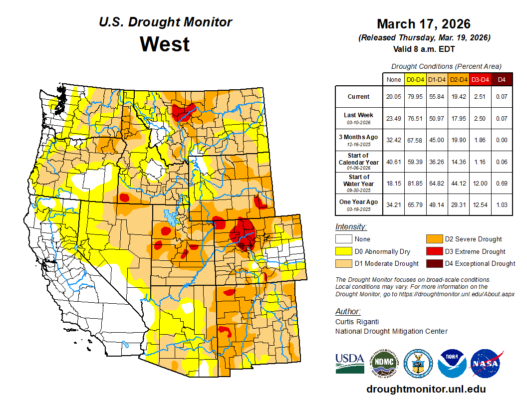
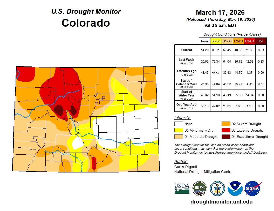
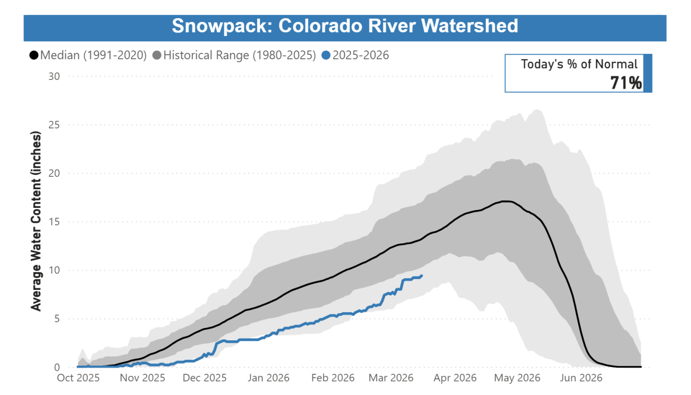
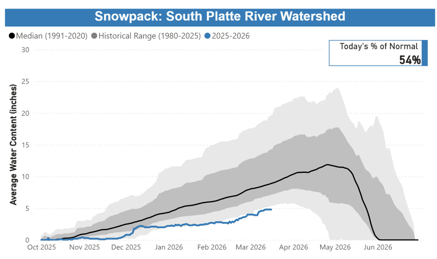
Snowpack as of March 16, 2026, was at or near record lows: The Colorado River Basin within Denver Water’s collection system was at 71% of normal. The South Platte River Basin within Denver Water’s collection area was 54% of normal. In Denver Water’s decades of records for its watershed collection areas, as of March 16, Colorado River snowpack ranked the third-worst on record, and the South Platte River snowpack remains ranked at the worst.

No matter what, Denver Water’s annual summer watering rules will always be in place during the irrigation season. And, it is likely that we will need to implement additional drought response measures this year. Denver Water’s response to drought conditions uses a layered approach, including the potential for additional watering restrictions, in order to preserve water supplies. Denver Water is developing recommendations on a potential drought response for the Board of Water Commissioners to consider over the next several weeks. 

Since 2000, Denver Water’s response to dry conditions in previous years included issuing a Drought Watch (voluntary restrictions) in 2002, 2003, 2004, 2012 and 2013. In some of those years (2002, 2003, 2004, 2013), Denver Water levied additional drought restrictions as part of declaring a Stage 1 level response, which required mandatory reductions in outdoor water use. 


Denver Water snowpack update for March 16, 2026 

  • Conditions remain highly concerning. Poor snowfall combined with warm temperatures have left us roughly 3 feet to 4 feet of snow short of where we’d prefer to be in the Denver Water collection area at this time. To reach the normal spring snowpack peak, which typically occurs in April, we need to see an additional 7 feet to 7.5 feet of snow this spring.
  • Reservoir storage conditions are below average, but in reasonably good shape: as of March 16, 2026, the reservoirs were 80% full versus an average of 85% full for this time. Those levels are also temporarily affected by the need to keep Gross Reservoir low during construction to raise the dam, a project designed to increase the storage capacity of the reservoir. 
  • Denver Water has been here several times over roughly 50 years of reliable records. On the positive side, we have experienced years that started dry and conditions dramatically improved in March, April and May. This year, however, we are running out of time to build the snowpack.
  • We’re reminding customers to do their part by making water-efficient upgrades, inside and outside, including rethinking their yards. These steps preserve water supplies and create more adaptable and drought-resilient landscapes that fit naturally into our climate. 
  • No matter what, Denver Water’s annual summer watering rules will always be in place during the irrigation season. Additional drought restrictions, voluntary or mandatory, will depend in part on how the rest of the snow season shapes up and will be aimed at preserving water supplies in case this unusually dry stretch deepens into a multiyear drought.  

Comment from Greg Fisher, Denver Water’s manager of demand planning: 

“Another weekend snowstorm was welcome, though it mainly benefited lower elevations along the Front Range. Unfortunately, mountain regions didn’t receive significant snow. The good news is that moisture we get in the Denver region should give our yards and landscapes a good dose of moisture, limiting the need for any watering this week,” said Greg Fisher, Denver Water’s manager of demand planning.

“Overall, we’ve had an extremely dry winter, and that continues this week — the last week of winter — with unusually warm temperatures expected across the region. That could lead to snow melt even at high elevations and highlights the need to conserve water and limit the pull on our reservoir storage. We continue to emphasize the need to keep irrigation systems off until mid-to-late May at the earliest, and to be prepared for outdoor watering restrictions this spring.

“It’s a good time to consider landscape changes to your yard, with plants and grasses that require far less water and are far more adapted to Colorado’s dry stretches. Such landscapes, once established, can get through dry stretches like this far easier, and with far less water, and still give your yard a colorful and vibrant look.”

Denver Water has many resources for homeowners looking for inspiration and information about landscapes that fit naturally into our dry climate. Click here for conservation and efficiency tips for outdoor irrigation and to get more details on ways to ColoradoScape your property, including through rebates for turf removal and a DIY guide for landscape changes, among many other potential water-saving steps. 


This chart shows the cumulative snowpack on March 16, 2026, in the area of the Colorado River Basin where Denver Water captures its water supply. The snowpack is 71% of normal, which ranks third-lowest on record for March 16. Image credit: Denver Water.
This chart shows the cumulative snowpack on March 16, 2026, in the area of the South Platte River Basin where Denver Water captures its water supply. The snowpack is 54% of normal, which ranks as the lowest on record for March 16. Image credit: Denver Water.

To learn more about the work Denver Water employees do to monitor the snowpack, read this TAP story about Denver Water employees snowshoeing into the forest near the top of Vail Pass in late February 2026 to conduct a monthly “snow survey.”

Additional information on Denver Water’s drought planning can be found here. Additional information on Denver Water reservoir levels, customer water use and snowpack can be found in the Water Watch Report, which is updated regularly during winter, spring and summer.


Novedades de Denver Water sobre el deshielo de la montaña y el suministro de agua

Novedades sobre el deshielo de la montaña del 16 de marzo de 2026 para el área de recolección de agua de Denver Water.


16 de marzo de 2026 | Escrito por:  Personal de TAP


Denver Water depende del deshielo de la montaña para el 90 % de su suministro de agua, el cual da servicio a 1.5 millones de personas en Denver y en los suburbios de alrededor.

En 16 de marzo de 2026, el deshielo de la montaña se encontraba cerca de niveles históricamente bajos: La cuenca del río Colorado dentro del sistema de recolección de Denver Water estaba al 71 % de lo normal. La cuenca del río South Platte dentro del área de recolección de agua de Denver Water estaba al 54 % de lo normal. En las décadas de registros de Denver Water sobre sus cuencas hidrográficas de recolección, al 16 de marzo el deshielo de la montaña en la cuenca del río Colorado ocupaba el tercer peor lugar y el deshielo de la montaña en la cuenca del río South Platte ocupaba el peor de todos.

Pase lo que pase, las reglas anuales de riego en verano de Denver Water siempre estarán vigentes durante la temporada de riego. Además, es probable que este año sea necesario implementar medidas adicionales de respuesta ante una sequía. La respuesta de Denver Water a condiciones de sequía utiliza un enfoque por niveles, que incluye la posibilidad de aplicar restricciones adicionales de riego para preservar el suministro de agua.  

Denver Water está preparando recomendaciones para la Junta de Comisionados del Agua de Denver sobre una posible respuesta a la sequía en las siguientes semanas.

Desde 2000, la respuesta de Denver Water a condiciones secas en años anteriores incluyó la emisión de una alerta de sequía (restricciones voluntarias) en 2002, 2003, 2004, 2012 y 2013. En algunos de esos años (2002, 2003, 2004 y 2013), Denver Water impuso restricciones adicionales por sequía como parte de la declaración de una respuesta de Nivel 1, la cual exigía reducciones obligatorias en el uso de agua en exteriores.

Novedades sobre el deshielo de la montaña de Denver Water al 16 de marzo de 2026

  • Las condiciones siguen siendo motivo de gran preocupación. Las escasas nevadas, combinadas con temperaturas cálidas, han dejado aproximadamente entre 3 y 4 pies de nieve por debajo de lo que sería deseable en el área de recolección de Denver Water para esta época.  Para alcanzar el pico normal de deshielo de la montaña en primavera, que por lo general se produce en abril, necesitamos ver entre 7 y 7.5 pies adicionales de nieve esta primavera.
  • Las condiciones de almacenamiento en los embalses están por debajo del promedio, pero razonablemente en buen estado: al 16 de marzo de 2026, los embalses estaban llenos al 80 %, frente a un promedio del 85 % para esta época. Estos niveles también se ven afectados temporalmente por la necesidad de mantener bajo el nivel del embalse Gross durante la construcción para elevar la presa, un proyecto diseñado para aumentar la capacidad de almacenamiento del embalse. 
  • Recordamos a los clientes que también pueden colaborar realizando mejoras para un uso eficiente del agua, tanto dentro como fuera del hogar, incluyendo replantear el diseño del patio. Estas medidas ayudan a preservar el suministro de agua y crean paisajes más adaptables y resilientes frente a la sequía, que se integran de forma natural en nuestro clima. 
  • Pase lo que pase, las reglas anuales de riego en verano de Denver Water siempre estarán vigentes durante la temporada de riego. Las restricciones adicionales por sequía, voluntarias u obligatorias, dependerán en parte de cómo evolucione el resto de la temporada de nieve y estarán orientadas a preservar el suministro de agua en caso de que este período inusualmente seco se convierta en una sequía de varios años.

Comentario de Greg Fisher, gerente de planificación de la demanda de Denver Water:

“Le dimos la bienvenida a otra tormenta invernal este pasado fin de semana, aunque solo beneficiaron áreas con elevación bajas en el Front Range. Desafortunadamente, las regiones montañosas no recibieron cantidades de nieve significativas. Las buenas noticias es que la humedad que recibimos en la región de Denver le dio a nuestros jardines y paisajismos una buena dosis de humedad y así limitar el riego esta semana.

“Hemos tenido un invierno muy seco y estas condiciones continuaran esta semana, la última semana de invierno, con temperaturas inusualmente altas anticipadas a través de la región. Continuamos enfatizando la importancia de mantener sus sistemas de riego apagados hasta mediados o finales de mayo y estar preparados para posibles restricciones de riego esta primavera.”

Denver Water cuenta con muchos recursos para propietarios de viviendas que buscan inspiración e información sobre paisajes que se integren de forma natural en nuestro clima seco. Haga clic aquí para obtener consejos de conservación y eficiencia para el riego exterior y conocer más detalles sobre maneras de aplicar ColoradoScapes en su propiedad, lo que incluye reembolsos por la eliminación de césped y una guía para realizar cambios en el paisajismo por cuenta propia, entre muchas otras medidas para ahorrar agua.

Puede encontrar información adicional sobre la planificación ante sequías de Denver Water aquí (en inglés). Puede encontrar información adicional sobre los niveles de los embalses de Denver Water, el uso de agua de los clientes y el deshielo de la montaña en el informe Water Watch Report (en inglés), que se actualiza con regularidad durante el invierno, la primavera y el verano.

Denver Water’s entire collection system. Image credit: Denver Water.

#Drought cueing #Aurora water restrictions in April, possibly dire limits this summer: “This is not a good situation this year at all,” Marshall Brown said — Aurora Sentinel #SouthPlatteRiver #ColoradoRiver #ArkansasRiver

West Drought Monitor map March 17, 2026.

Click the link to read the article on the Aurora Sentinel website. Here’s an excerpt:

March 19, 2026

City water officials are sounding increasingly urgent alarms about Aurora’s water supply, warning that worsening drought conditions and poor snowpack could force early and potentially escalating restrictions this year. Aurora Water General Manager Marshall Brown told city leaders yesterday that the situation has deteriorated enough that staff will likely recommend a formal Stage 1 drought declaration as early as April 6, nearly a month ahead of the city’s typical seasonal watering restrictions. If approved by the City Council, new limits on water use would take effect April 7, officials said.

“Our water supply situation is actually bleak enough that, if things don’t improve, and we don’t get a community response that we need during a Stage 1 restriction, the forecast indicates we may be in a Stage 2 restriction by the end of the year,” Brown said. “That would be really dramatic.”

Aurora breaks water supply and restrictions into four categories:

  • Normal: Current permanent rules limit landscape irrigation from 10 a.m. – 6 p.m. for a maximum of three days per week.
  • Stage I: Considered when reservoir levels are lower, often reducing outdoor irrigation to two days per week.
  • Stage II: More stringent, potentially reducing irrigation to one day per week.
  • Stage III: Emergency conditions with severe restrictions, including no landscape irrigation.

The warning marks a notable shift from just weeks ago, when city leaders said conditions were concerning but not yet dire. Now, officials say a combination of record warmth, minimal precipitation and dwindling snowpack has pushed the system closer to critical thresholds. According to the latest Aurora Water report, conditions across Colorado remain deeply dry. More than 75% of the state is classified as abnormally dry, with over half in moderate drought and significant portions in severe to extreme drought. February and March so far have offered little relief, statewide water officials reported. Those trends are expected to continue. Long-range forecasts from federal agencies indicate warmer and drier-than-normal conditions through the spring, further reducing the likelihood of meaningful runoff to replenish reservoirs.

The latest Seasonal Outlooks through June 30, 2026 are hot off the presses from the #Climate Prediction Center: Ruh-Roh!

Resolution Copper to start drilling at Oak Flat after court decision — AZCentral.com

Henry Muñoz, a former miner and resident of Superior, Arizona, overlooks a portion of Oak Flat—part of Tonto National Forest and a sacred site for the San Carlos Apache. Credit: Wyatt Myskow/Inside Climate News

Click the link to read the article on the AZCentral website (Debra Utacia Krol). Here’s an excerpt:

March 16, 2026

Key Points

  • A U.S. Court of Appeals denied a request to halt a land exchange at Oak Flat, clearing the way for mining work to begin.
  • Resolution Copper now owns the land, which is sacred to the Apache people, and plans to begin exploratory drilling.
  • Opponents, including the San Carlos Apache Tribe, have appealed to the U.S. Supreme Court, citing religious freedom.

Resolution Copper told the U.S. Supreme Court it would begin exploratory drilling in the Oak Flat area on March 16 after the 9th U.S. Circuit Court of Appeals turned down a bid from a coalition of environmentalists, the San Carlos Apache Tribe and a group of Apache women to halt a contentious land exchange. The three-judge panel issued its decision late Friday, March 13. Resolution relayed documents to the high court affirming the land exchange occurred shortly after the court rendered its decision. Resolution now owns Oak Flat, a location sacred to the Apaches and other Native people. The Forest Service issued the final record of decision March 16 finalizing the land exchange.

“The national security of America depends on our ability to harness the abundant natural resources we are blessed with in this country,” said Agriculture Secretary Brooke Rollins in a statement. “The Resolution Copper project is a prime example of bureaucratic and legal chokeholds preventing our rural communities, supply chains, and defense industry from producing the minerals we need right here in America.”

The appeals court denied an injunction in three cases, blocking a legal move that could have halted progress on the handover of the 2,200-acre site and another 211 acres currently within Tonto National Forest to Resolution, the British-Australian mining company, while the lawsuits continue to make their way through the court system. Miles Coleman, one of the attorneys representing the Brown-Lopez family and other Apache women, said the firm filed an appeal with the U.S. Supreme Court over the weekend.

“The transfer and destruction of Oak Flat would be a tragic departure from our nation’s founding promise of religious freedom,” Coleman told The Arizona Republic. He said the emergency application with the Supreme Court asked to preserve the status quo and protect Oak Flat.

The ruling came more than two months after the judges heard the three cases on Jan. 8. The judges turned the three down because they said the cases were “unlikely to succeed on the merits.”

A shrinking #ColoradoRiver is forcing farms to change: From low-flow nozzles to baling hay at night, see how farmers are adapting to less water — Caitlin Ochs (High Country News) #COriver #aridification

Lamar Fields, a tribal member, gathers blue corn to sample. With increasingly unreliable access to water, flexible crops like corn have become integral to the farm’s survival. To increase revenue, the farm built a mill to process crops like blue corn. Caitlin Ochs

Click the link to read the article on the High Country News website (Caitlin Ochs):

March 12, 2026

For a century, the Colorado River has been managed in pieces. Legally and politically, it’s divided into two basins, with each state and community focused on securing its respective water supply. But that is not how a river functions. The Colorado River is an interconnected system, sustained by Rocky Mountain snowpack, rainfall and groundwater.

It is fragile, and under increasing stress. Two and a half decades into this century, the river that built the modern West has 20% less water flowing through it than it did on average in the last century. As heat and drought intensify, so do the stakes: Failure to recognize the severity of changing conditions, managing the river in parts without considering needs of the whole and inadequate planning for long-term shortages put the future of all the basin at risk.

For the last five years, I have documented how the Colorado River Basin’s farmers are navigating water shortages and uncertainty amid deep political divisions about the river’s future. This project, called American Adaptation, examines three agricultural communities whose survival is threatened by a shrinking river, examining what happens to people when policies and water management struggle to keep pace with a changing climate. 

In one of the river’s northern watersheds, the Ute Mountain Farm and Ranch Enterprise is adapting its management as the water it relies on becomes less dependable. In central Arizona, farmers have returned to well water after becoming the first communities to have their supply cut off completely due to the basin-wide shortage. And in California’s Imperial Valley, the farms that receive the river’s largest water allocation are under growing pressure to share the burden of shortage. 

Together, their stories illustrate the stakes — and rising tensions — of the  current negotiations over the river’s future management. States, tribal nations and the federal government are reckoning with 100 years of developing water infrastructure based on assumptions of continuing abundance and expansion. These ideas — and the legal frameworks built around them — are colliding with the reality of a river with much less water than expected, raising complex questions about what the Colorado can sustain, how its water should be used and who will shoulder the necessary cuts.

The Dolores Project, located in the Dolores and San Juan River Basins in southwestern Colorado, develops water from the Dolores River for irrigation, municipal and industrial users, recreation, fish and wildlife, and hydroelectric power. It also provides vital water to the Dove Creek area, central Montezuma Valley area, and to the Towaoc area on the Ute Mountain Ute Indian Reservation. McPhee Dam and Reservoir is the principle storage feature of the Dolores Project which includes a system of canals, tunnels, and laterals to deliver water to over 61,000 acres of land. Photo credit: Kenny Browning/Flickr

When Water is Uncertain

On 7,600 acres painstakingly carved out of desert brush, the Ute Mountain Farm and Ranch, a tribally run enterprise of the Ute Mountain Ute nation, produces cattle, alfalfa, corn and wheat. Its operations are led by Simon Martinez, Eric Whyte and Michael Vicente, who have deep personal connections to the enterprise. Martinez helped build the dam for the reservoir that provides the farm’s water, while Whyte cleared desert brush and mapped where the fields would go. Vicente, as the lead irrigator, can account for every drop of water that’s used.

In good years, the farm’s circular fields flourish in brilliant green bursts. But the past decade has brought increasingly erratic access to water. Each spring, the local irrigation district announces potential cuts after assessing snowpack runoff and the available water stored in nearby McPhee Reservoir. In 2021, the farm received just 10% of its water allocation and was forced to leave 6,000 acres unplanted. In 2022, 30% of the water came in, and last year, 34%, which the farm was able to increase to 50% after leasing shares from other water users.  

To survive, they adapted. Every year, the farm’s leadership creates numerous plans for different water scenarios. They have applied for grants, implemented low-flow nozzles in the irrigation system, installed small-scale hydropower generators. They joined a Land Institute pilot program to test crops that use less water. 

On a day in late May [2022] when wildfire smoke obscured the throat of an ancient volcano called Shiprock in the distance, I visited the Ute Mountain Ute farming and ranching operation in the southwestern corner of Colorado. Photo credit: Allen Best/Big Pivots

“We still haven’t thrown the towel in,” said Simon Martinez. “Nobody ever thought, when the reservoir was built, that there wouldn’t be enough water to supply the farms that have been put out here. It’s not only us; it’s happening all through southwestern Colorado.”

Low-water years leave their mark. Brush and scrub quickly reclaim unplanted fields. Employees laid off during dry years are hard to replace. During consecutive years of heat and drought, farms that rely on the basin’s many smaller reservoirs become even more vulnerable. As the number of dry years grows, it is increasingly uncertain how much shortage the Ute Mountain Farm and Ranch Enterprise can sustain in the long term, despite the farmers’ determination to adapt. 

Arizona Rivers Map via Geology.com.

When Water Disappears

Hundreds of miles south, Will Clemens manages his uncle’s 2,100-acre farm, cultivating cotton, alfalfa and Bermuda grass. Farmers in this region operate with a year-round growing season punctuated by dust storms and summer monsoons. 

In this intense environment, wells were the only water source before Colorado River water became available. Until the 1980s, farmers drew their water from deep underground, contributing to fissures, land subsidence and drying wells. The completion of the Central Arizona Project alleviated the pressure, delivering farmers cheap imported river water that was classified as lower priority and the first to be cut during shortages. Deliveries continued until 2022, when low water levels at Lake Mead triggered federal cuts, and central Arizona farms lost access. In response, Clemens’ local irrigation district drilled a dozen new wells. 

Without the river, Clemens and his neighbors have seen the canals’ water drop. At times, their irrigation district will cut off water before a field is fully irrigated, or struggle to keep up with the farmers’ water orders. More pressure on groundwater raises questions about what is sustainable in the future. Large parts of Arizona have no legal limits on pumping water from the ground. Even areas with legally protected groundwater have failed to meet a safe yield goal set in the 1980s to balance groundwater taken each year with naturally replenished water by 2025.

Some central Arizona farmers are selling or leasing their farmland to solar developers, as water dwindles and energy demands grow. Miles up the road from where Clemens farms, sleek black grids of solar panels gleam next to green alfalfa. For years, Arnold Burruel, Clemens’ uncle, has been in talks with a solar developer about selling the land. 

“I’ve been asking myself: Does America really need to be in the agriculture industry?” Burruel said. “America is not totally enamored with agriculture when it comes to pesticides, herbicides, groundwater, GMOs — all of the above. We are at a crossroads. Are we going to continue to farm the way we are farming and heavily subsidize growers that can’t make ends meet? Society has to come up with an answer.”

California uses the most water of any state in the Colorado River Basin, partly for its cities along the Pacific Coast but a substantial amount for agriculture in the Imperial Valley. Photo December 2015/Allen Best

When Water is Abundant

From above, the All American Canal forms a stark blue line, slicing through the Algodones Dunes. One of the world’s largest canals, it is fed by the Imperial Dam, which diverts up to 6.8 million gallons of water each minute from the Colorado River.

This is the only water source for 500,000 acres of Imperial Valley farmland. Farms here are protected by senior rights at low risk of cuts and receive regular releases from Lake Mead, the largest reservoir in the United States. During summer months, the sun looms over the valley’s dusty, flat horizon, and temperatures often climb above 100 degrees. Despite decades of drought and growing water shortage, water has flowed uninterrupted to the Imperial Valley. 

Fourth-generation family farmer Jack Vessey, who oversees a 10,000-acre produce operation, knows the canal system well. Growing up, he searched for places to swim on hot summer days.

“We take water seriously,” said Vessey, who added sprinkler systems, which are more efficient than flood irrigation. In recent years, the Imperial Irrigation District joined other communities throughout the basin in voluntarily cutting water through 2026 in exchange for federal funds. The district’s compensation was several hundred dollars more per acre-foot than other participants. But as funding set aside for Western water by the Biden administration is drawn down, it is unclear how much will be available to pay for future voluntary cuts.

Vessey is aware of the growing pressure on the river and the valley’s farms, but he emphasizes that the community has helped with shortages and is protective of its water.

“I have a responsibility for the people who work here to make sure we survive,” he said. “I have to be a little selfish at some point and say, ‘Keep giving us the water we need.’ I know we’ve got to do our part, but I can look in the mirror and say we are not wasting water, we are growing food people need. 

“If it wasn’t for that canal coming off the Colorado River, this would just turn to desert.”

This project was supported by the National Geographic Society’s World Freshwater Initiative.

We welcome reader letters. Email High Country News at editor@hcn.org or submit a letter to the editor. See our letters to the editor policy.

This article appeared in the March 2026 print edition of the magazine with the headline “The Shrinking River.”

Colorado River “Beginnings”. Photo: Brent Gardner-Smith/Aspen Journalism

#Colorado Water Conservation Board Invests in Critical Water Projects as Demand for Funding Remains High

Colorado Drought Monitor map March 17, 2026.

Click the link to read the release on the CWCB website:

March 19, 2026

Yesterday, at its March Board Meeting, the Colorado Water Conservation Board (CWCB) approved more than $13 million in funding for 48 water projects across the state through its Water Plan Grant and Water Supply Reserve Fund programs, bringing the totals for the fiscal year to more than $40 million for 136 locally-driven projects across the state. These advance critical efforts to help communities be more prepared for drought and wildfires, improve water resilience, and secure Colorado’s water future.

“Organizations across the state are implementing these projects to do their part in moving Colorado’s Water Plan Partner Actions forward,” said CWCB Director Lauren Ris. “These locally driven efforts—from agricultural producers to municipalities to watershed groups—demonstrate a collective commitment to building a resilient, and water-wise future. The importance of this work is underscored by worsening drought conditions. We are putting efforts to protect water resources front and center.”

The funding reflects both the urgency of Colorado’s current water challenges and the overwhelming demand for resources. Funding requests far exceeded available dollars, highlighting the volume of high-impact projects ready for implementation across the state.

These investments are made possible through sports betting taxes in Colorado, a funding stream that continues to play a critical role in advancing Colorado’s water priorities.

“This level of demand for our Water Plan Grants shows just how much water users across Colorado rely on these investments,” said Colorado Department of Natural Resources Executive Director Dan Gibbs. “It also speaks to the incredible work happening on the ground to conserve water and build more resilient systems that will serve communities and our water resources  for generations to come.”

Funded projects reflect key priorities of the Colorado Water Plan, including water conservation, wildfire resilience, and water storage. This includes projects focused on conserving water and improving efficiency, such as funding for new Water Efficiency Plans—an essential tool for long-term water supply planning—as well as initiatives like urban turf replacementresilient school landscapes with smart irrigation, and comprehensive outdoor water budgeting.

The CWCB also continues to invest in projects that help communities prepare for wildfire impacts through watershed restoration and implementation of Wildfire Ready Action Plans, helping protect critical water resources from post-fire risks.

And in Colorado’s current warm, low-snowpack water year, investments in water storage are critical. Funding this grant cycle supports projects that increase or evaluate storage capacity—an essential strategy for capturing and managing water when supplies are limited. These efforts include feasibility studies and improvements to reservoirs and dams in communities across the state.

Finally, the Water Supply Reserve Fund grant investments this grant cycle includes projects such as post-fire diversion infrastructure improvements in Rio Blanco County and enhanced groundwater monitoring efforts in the South Platte Basin—both of which strengthen local water resilience and inform long-term water management.