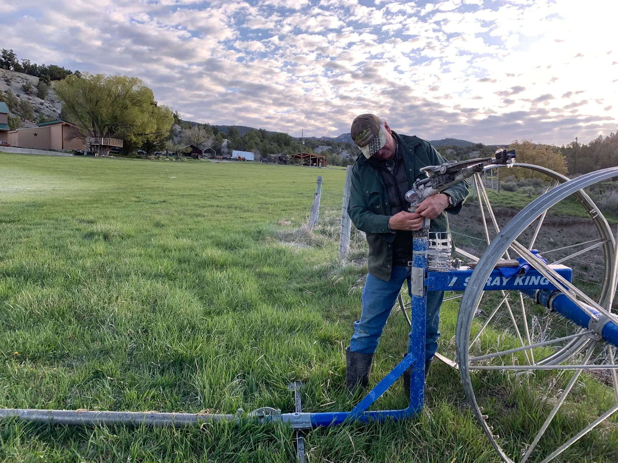
As the American West gets hotter, farmers will need more water to irrigate the same amount of crops1. More water will also be required to cool the generators that will supply energy to an ever-increasing number of air conditioning systems in hundreds of thousands of homes and businesses2.
Why hotter air means thirstier crops
Warmer air has a higher vapor pressure deficit, so it “pulls” more moisture out of soil and plant leaves, increasing evapotranspiration. This means that to get the same crop yield, farmers must apply more water per acre because a larger fraction of applied water is lost to the atmosphere rather than staying in the root zone.
Earlier snowmelt and reduced snowpack in Western mountains expose soils sooner to heat and sun, drying them out faster and further increasing irrigation needs. The same corn field will need more irrigation in 2050 than it did in 1980 just to achieve the same yield, because the atmosphere is “thirstier.”
Why hotter days use more electricity
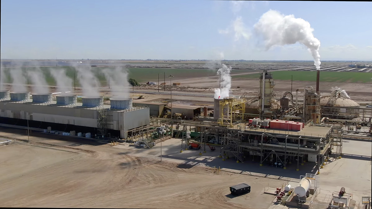
Steam rising from cooling towers at the CalEnergy JM Leathers Geothermal Plant at California’s Salton Sea. Photo by Robert Marcos
Higher temperatures drive up electricity demand because homes, offices, and industry run air conditioners and refrigeration harder and for longer periods. Much of that electricity still comes from thermoelectric power plants (coal, gas, nuclear) that use large volumes of freshwater for cooling, either withdrawing it and returning it warmer or consuming a portion through evaporation3.
As air and water warm, these plants run less efficiently and may need even more cooling water per unit of electricity generated, increasing water use just when rivers and reservoirs are under stress. In very hot, dry years, this can create a feedback: heat raises AC demand, AC demand raises power plant water demand, low flows and high water temperatures then constrain power plants, risking reliability problems4.
Warming reduces the share of precipitation that reaches reservoirs and aquifers: more evaporates or is soaked up by drier soils before it becomes runoff. Western water systems and legal allocations were designed assuming a more stable climate and more reliable snowpack; under warming, those assumptions are breaking down, reducing dependable supplies for both farms and power plants. The result is a tightening water budget: less water coming into the system at the same time that crops, cities, and energy systems are all asking for more.
The seven U.S. states that make up the Colorado River basin are struggling to agree on how best to manage the river’s water as its supply dwindles due to climate change and a period of prolonged drought. Their negotiations, which are not open to the public, missed a Feb. 14, 2026, deadline the federal government had established, after which federal officials said they would impose their own plan.
The federal government has not yet done so, but the prospect of such an action is not good news for the nearly 40 million people who depend on the Colorado River for water, energy, agriculture and recreation, nor for the estimated US$1.4 trillion in economic activity the river supports.
But compromise on Colorado River management is possible and, in fact, was achieved to curb California’s water use in the 2000s, to negotiate an interim agreement to coordinate operations at the Lake Mead and Lake Powell reservoirs in 2007, and to enact contingency plans to manage drought in 2019. But this time around, circumstances are different.
The negotiators for the states had long-standing relationships and built trust by frequently communicating outside formal meetings and seeking to listen to and understand other states’ perspectives, even if they didn’t agree.
The states also agreed to use the bureau’s computer model for analyzing scenarios of climate change and management decisions. That meant all the negotiators were looking at the same data when delving into possible options. And the political and social environment was less polarized than today.
The current situation
In this round of negotiations, federal leadership has been lagging. The Department of the Interior has not made clear what the consequences might be for the states if they fail to agree. The U.S. Bureau of Reclamation has been without a permanent commissioner since President Donald Trump retook office in January 2025.
The states are fractured into subgroups, according to whether they are in the river’s Upper Basin – Colorado, Wyoming, Utah and New Mexico – or the Lower Basin, which includes Arizona, Nevada and California. Each basin group holds strong positions and has generally been unwilling to shift.
Each basin group is using a different set of assumptions for the bureau’s computer model to explore options. And the discussion often gets stuck on details, which prevents progress toward broader agreements.
But those relatively new challenges to Colorado River compromise are not an excuse for failure.
Interior Secretary Doug Burgum, center between flags, meets with governors and representatives of the seven Colorado River basin states in January 2026. U.S. Department of the Interior via X
A way forward?
The current negotiations have all been done behind closed doors. From talking with people involved in the negotiations, we understand the negotiators have been left to set their own agendas and meeting plans and conduct their own communications and follow-up, with no formal facilitators.
It’s reasonable to expect the negotiators to be ready to represent their states’ interests, working through an incredibly complicated landscape of hydrology, climate and management scenario modeling, water law and administration, and politics. But we believe it’s unreasonable – and unrealistic and unfair – to expect them to also be experts at designing and facilitating an effective process for sorting out their differences.
Federal officials are not necessarily the best people to run the process either. And if the agency that ultimately needs to approve any deal is the one leading the process, real or perceived biases about the states or key issues in the agreement could further complicate the discussions.
We believe that agreement between the seven states is still possible. It may be less effective to bring in a third-party facilitator at this stage in the negotiation process, though, because of the degraded trust, hardened positions and shortage of time.
A more hopeful possibility is that the bureau adopts short-term rules that would give the states another chance to negotiate a longer-term deal – ideally with an unbiased third-party facilitator for support.
A collaborative and consensus-based planning process in the Yakima River Basin in Washington state in the early 2010s is evidence that while nobody gets everything they want in a negotiated agreement, “if they can (all) get something, that’s really the basis of the plan,” as a Washington state official told The New York Times.
We are two and a half decades into the Southwest’s most severe drought of the last 1,200 years, and this winter’s snow dearth is one of the most extreme on record.
Without an April-May miracle, human-caused climate change likely will finally catch up with the Colorado River—and the 40 million people who rely on it—in the form of a full-blown crisis later this year.
“Drought” may be too hopeful a word, since it implies an eventual end. Most climate scientists refer to the phenomenon as “long-term aridification,” caused by a lack of rain and snow and warming temperatures.
The West has just experienced its warmest winter since record-keeping began in 1895. The average October-through-December temperature in some parts of the region has been more than 8° F warmer than the 20th-century mean. This is a huge anomaly.
In Gunnison County, Colorado, one of the colder places in the nation, the average minimum temperature for that four-month stretch was about 19° F. That doesn’t seem so bad until you realize that back in 1990, another dry, warm winter, the corresponding measure was 13.6° F. For the Upper Colorado River Basin, the average minimum temperature for that four-month stretch was about 26° F, the warmest on record.
The warmer temperatures tinker with the health of the watershed.
This water year, which began Oct. 1, started out with record-high precipitation in some areas, most of which fell as rain. That helped fend off severe drought conditions. But what really counts is the mountain snowpack, which serves as a giant natural reservoir that supplies at least 70% of the Colorado River’s water each year. Warm temperatures have left some areas snow-free even in parts of Wyoming, where the white stuff normally would be piled high in March.
The diminishing snow has, in turn, shrunk the Colorado River. The “natural” flow—or an estimate of how much water the river would carry without upstream diversions or human consumption—has been below 15 million acre-feet (MAF) at Lees Ferry during 20 of the last 26 years, with an average flow of 12.25 MAF during that time.
This matters, because when the Colorado River Compact of 1922 parceled out the river’s waters, the river was assumed to carry an average annual flow of at least 16.5 MAF. Demand has significantly exceeded supply for the last 26 years, forcing the drawdown of the watershed’s big savings accounts, Lake Powell and Lake Mead, to about one-third of their capacity.
Meanwhile, to comply with the Colorado River Compact of 1922—the document that serves as the Ten Commandments for the management of the river’s waters—the Upper Basin States must release, on average, at least 7.5 MAF from Glen Canyon Dam each year.
Given that the Upper Basin states need a bunch of water to keep their cities and farms from drying up, and that an additional 800,000 acre-feet evaporates or seeps into the underlying rocks at Lake Powell each year, you can see how the warming climate wreaks havoc on the math of the Colorado River.
The entire river system now teeters on the brink, and this year’s snow drought may be what pushes it over the edge.
The back of Glen Canyon Dam circa 1964, not long after the reservoir had begun filling up. Here the water level is above dead pool, meaning water can be released via the river outlets, but it is below minimum power pool, so water cannot yet enter the penstocks to generate electricity. Bureau of Reclamation photo. Annotations: Jonathan P. Thompson
The Bureau of Reclamation’s latest forecast says Lake Powell’s surface level is likely to drop below the minimum level needed for power production later this year. This so-called “deadpool” would not only mean the end of hydropower production, it would also force all of the dam’s releases to go through the river’s 8-foot-wide, steel outlet tubes, which were not made for sustained use. This could compromise the tubes and the dam itself.
It’s possible that the dam would even be shifted to a run-of-the-river operation, in which releases equal the amount of water flowing into the reservoir, minus evaporation and seepage. That would almost certainly result in water shortages downstream, at the very least for the Central Arizona Project, which serves the Phoenix metro area.
This quandary didn’t sneak up on us.
The seven Colorado River states and the federal water managers can’t agree on who should make what cuts in consumption. The feds, meanwhile, haven’t gotten around to re-engineering Glen Canyon Dam or creating a bypass around it that would enable the water to keep flowing. It’s almost as if they’ve been paralyzed by the belief that dry winters were just a minor glitch.
Now, as the spring runoff gets underway, it has become clear that nature won’t save us: We have no choice but to live within increasingly meager limits.
Jonathan Thompson is a contributor to Writers on the Range, writersontherange.org, an independent nonprofit dedicated to spurring lively conversation about the West. He is a longtime journalist and author about the West.
Click the link to read the article on the NOAA website:
March 20, 2026
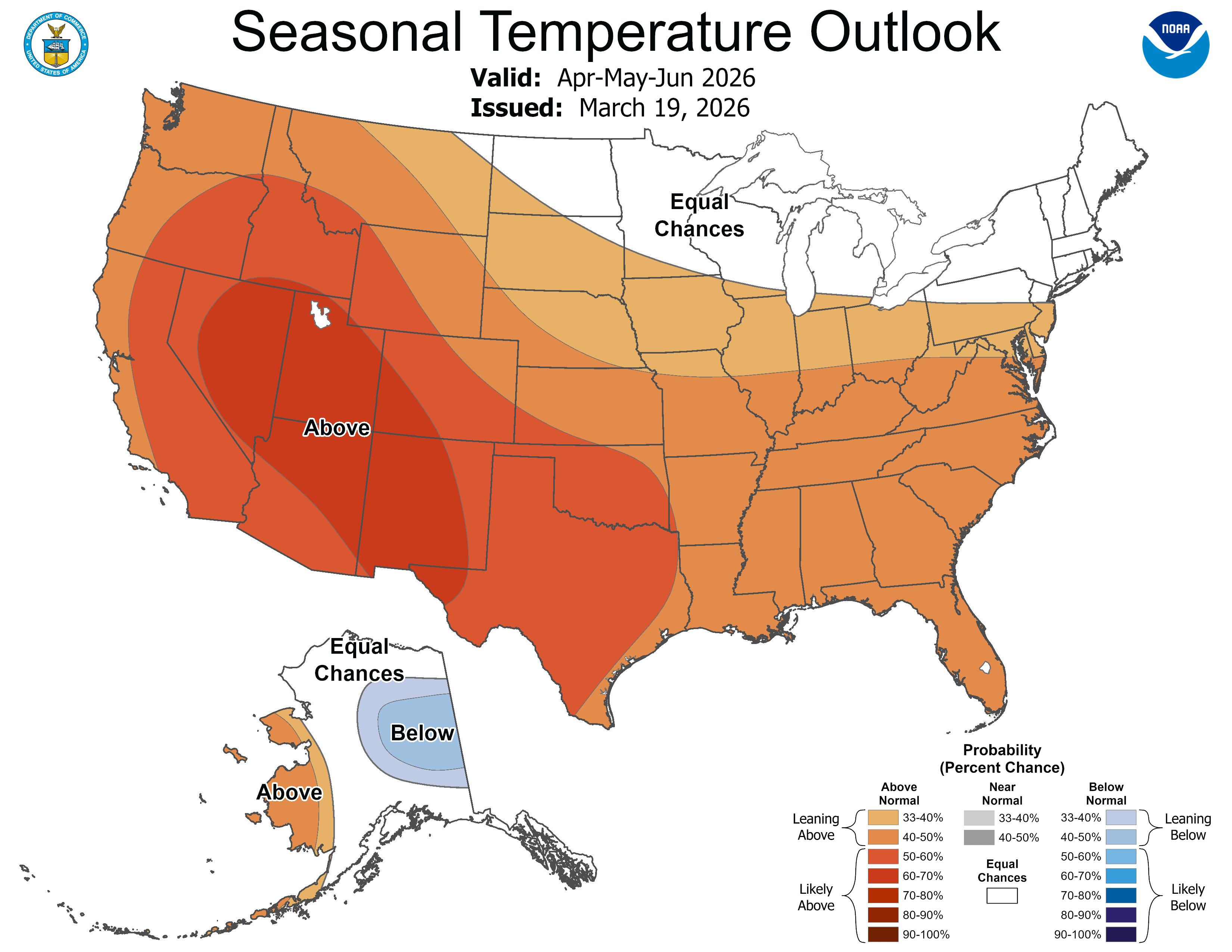
Drought conditions are forecast to worsen or develop for many areas in the West and south-central Plains, according to NOAA’s Spring Outlook released today for April through June. Forecasters from NOAA’s National Weather Service also predict above-normal temperatures for the majority of the U.S.
“Factors influencing NOAA’s Spring Outlook include the El Niño-Southern Oscillation (ENSO), low snowpack in the West and soil moisture content throughout the lower 48 states,” said Ken Graham, director of NOAA’s National Weather Service. “This spring will also feature a transition from La Niña to ENSO-neutral conditions, meaning neither El Niño nor La Niña.”
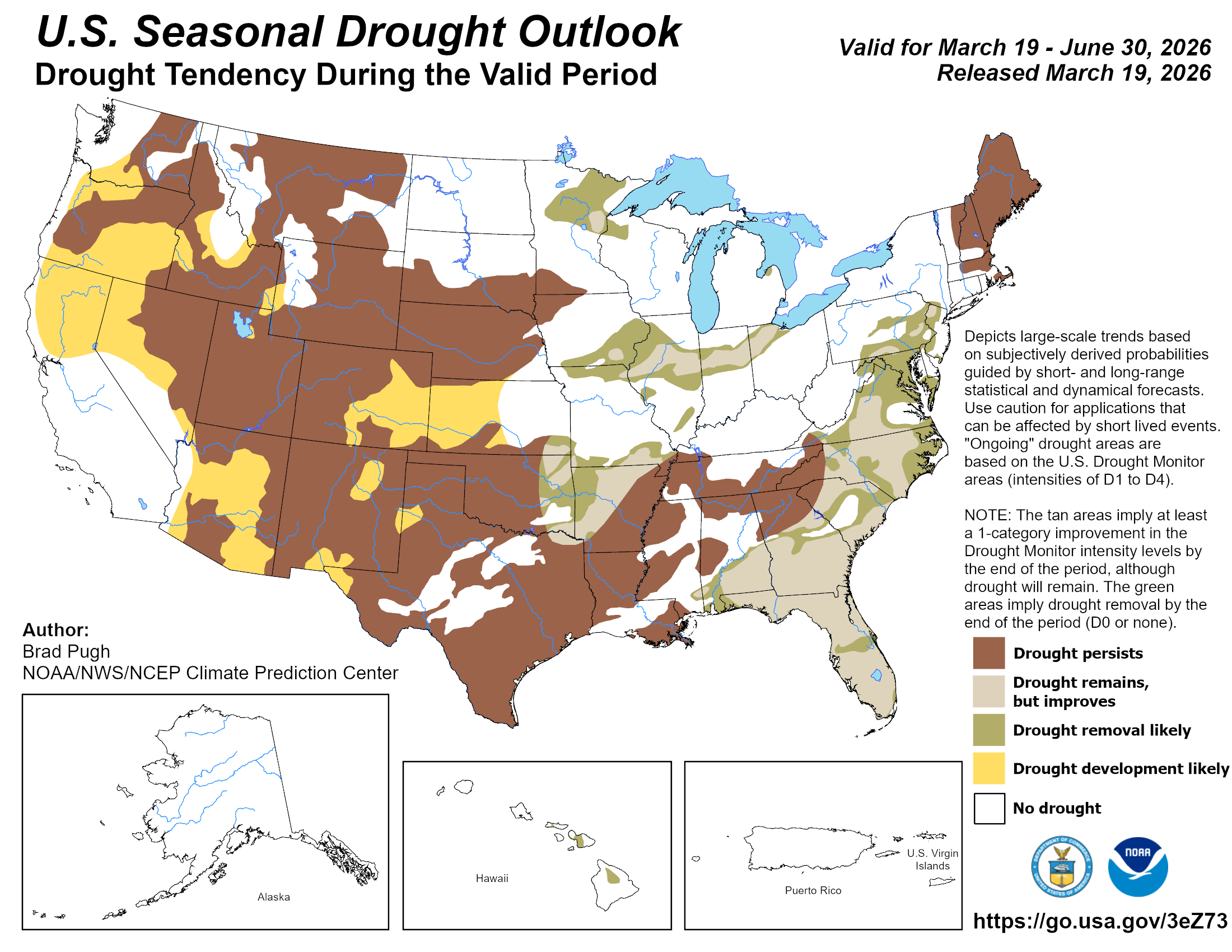
This map depicts where drought persistence, development or improvement is the most likely outcome based on short- and long-range statistical and dynamical forecasts from March 19 through June 30, 2026. (Image credit: NOAA) Download Image
As of mid-March, moderate to exceptional drought conditions exist across 55% of the continental United States.
“Drought conditions worsened or developed for much of the Great Plains, Lower Mississippi Valley, and Southeast U.S. due to warmer and drier than normal conditions this winter,” said Jon Gottschalck, chief of the Operational Prediction Branch, NOAA’s Climate Prediction Center. “Drought is likely to persist across much of the West while developing in parts of the Pacific Northwest, Great Basin, central Rockies and Southwest. Dry conditions are expected to improve for some areas in the Midwest and Atlantic seaboard.”
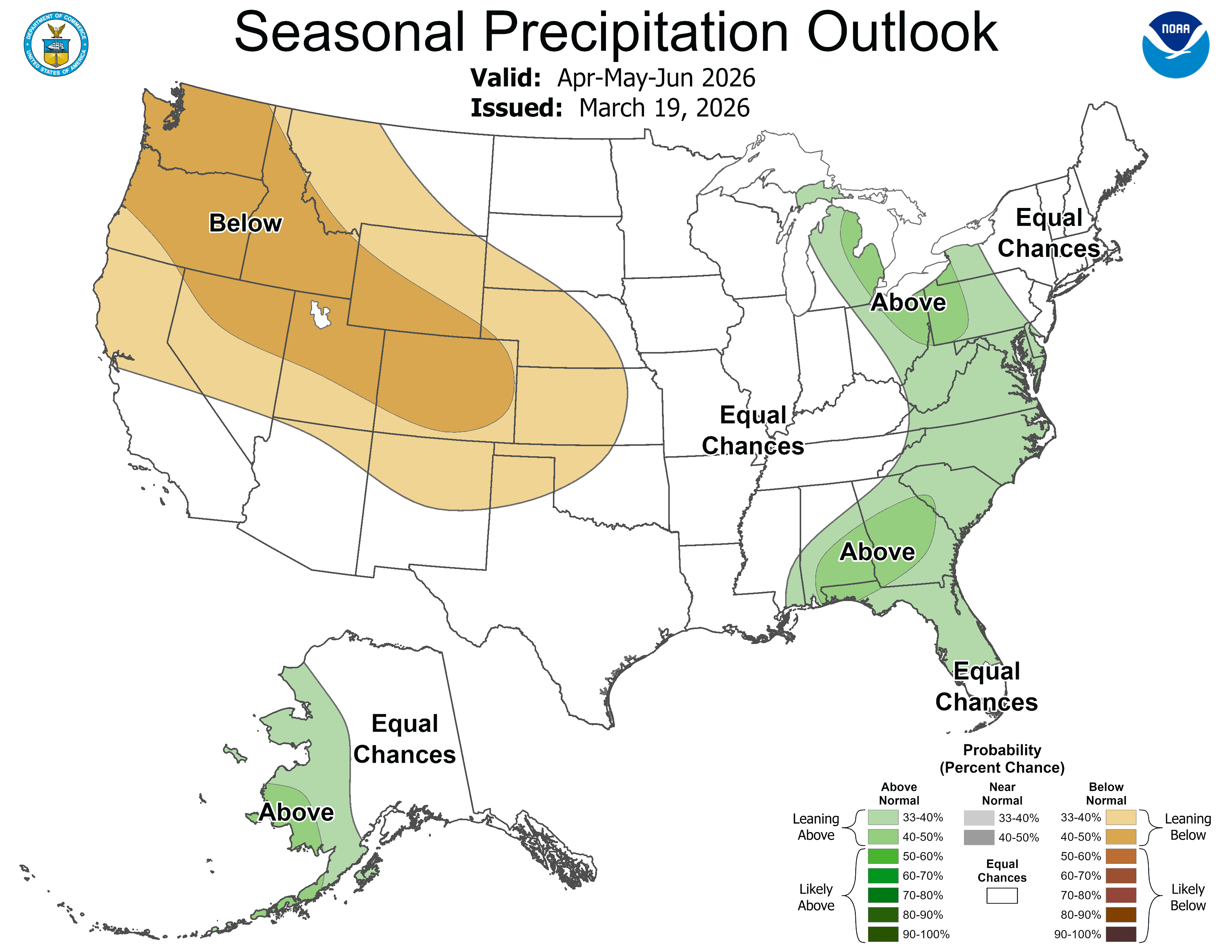
The temperature outlook for April through June shows above-normal temperatures are favored across the majority of the western U.S. eastward to include much of the Plains, the lower and middle Mississippi Valley, the Ohio Valley, the Tennessee Valley, the Southeast and the southern Mid-Atlantic. The highest likelihood of enhanced warmth ranges from the Southwest to the Inter-Mountain West. Below-normal temperatures are forecast for east central Alaska.The precipitation outlook favors below-average precipitation for the Pacific Northwest, parts of the Great Basin, Southwest, central High Plains and most of the Rockies. The greatest likelihood of below-average precipitation is forecast from the Pacific Northwest to the central Rockies. While above-normal precipitation is forecast for western Alaska, the eastern Great Lakes, mid-Atlantic and parts of the Southeast.
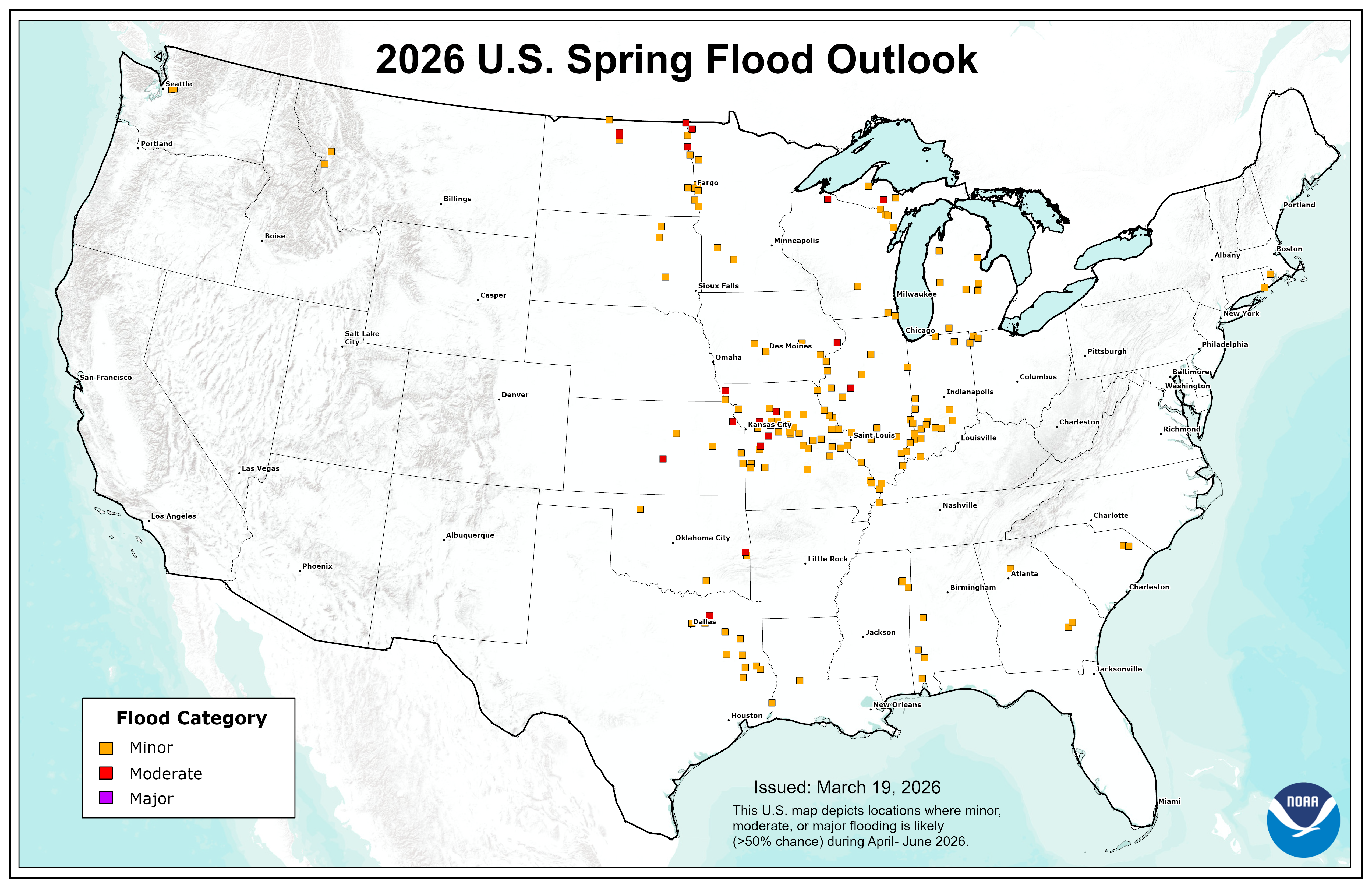
Spring flood risk
This map depicts the locations where there is a greater than 50% chance of minor, moderate or major flooding from April through June, 2026.(Image credit: NOAA) Download Image
NOAA’s National Hydrologic Assessment, issued by NOAA’s National Water Center, evaluates a number of factors, including current conditions of snowpack, drought, soil saturation levels, frost depth, streamflow and precipitation.
The overall flood risk across most of the continental U.S. for Spring 2026 is currently assessed as normal to below normal. This risk determination was made primarily because of a dry and warm winter that resulted in dry soils over much of the eastern U.S., mitigating the threat of rainfall-driven flooding. Additionally, a well-below-normal snowpack across most of the country will reduce the risk of snowmelt-driven flooding.
However, the Red River of the North and the lower Ohio Valley typically experience flooding annually; therefore, flooding is anticipated in these basins this year as well.
“We anticipate typical spring flooding this year over portions of the Greater Mississippi River Basin, but the risk for widespread significant flooding is low,” said Ed Clark, director of NOAA’s National Water Center. “However, it is crucial to remember that heavy rainfall has the potential to lead to a major flooding event.”
Flooding can occur rapidly from intense rainfall, even in regions with a generally low risk. Rainfall intensity and location can only be accurately forecast days in the future, and flood risk can change rapidly. Stay current on flood risks in your area with the latest official watches and warnings at weather.gov. For detailed hydrologic conditions and forecasts, please visit water.noaa.gov.
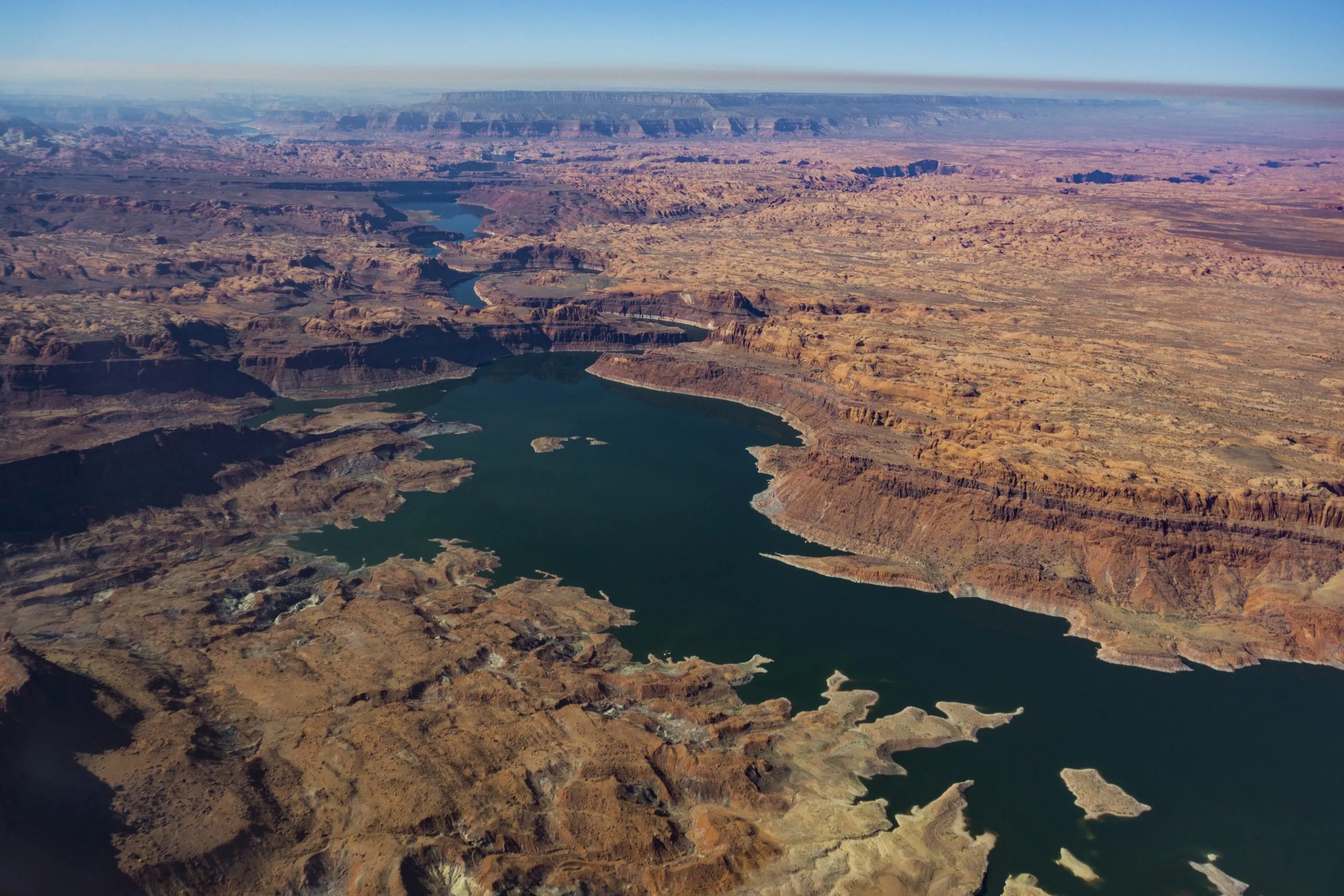
Lake Powell, on the Colorado River, is seen from the air in 2019. The Upper Basin states are planning how to potentially fill a dedicated pool in the nation’s second largest reservoir. CREDIT: ECOFLIGHT
With a Lake Powell conservation pool nearly guaranteed for the future of Colorado River management, the four Upper Basin states are exploring and refining the ways they could fill it.
Conservation by those states (Colorado, New Mexico, Utah and Wyoming) could be one of the keys to reaching a deal among the seven states that share the Colorado River and an important part of the framework for managing the drought-stricken river after this year. The water saved by the Upper Basin states could be stored in Lake Powell as a means of maintaining higher water levels and as an insurance policy against drastic cuts.
This type of pool isn’t yet being used in Lake Powell; it would have to be established by an agreement among the seven states. An agreement in the 2019 Drought Contingency Plan allowed for a 500,000 acre-foot Upper Basin storage pool in Lake Powell, but so far, the states have not utilized this and the agreement expires this year.
The Upper Basin and Lower Basin (California, Arizona and Nevada) have been at an impasse for more than two years about how the nation’s two largest reservoirs — Lake Powell and Lake Mead — will be managed and shortages shared in the future. The situation has never been more dire: The current guidelines for river management expire at the end of the year, while record-low snowpack is expected to push reservoir levels below critical thresholds. The seven states have blown past two deadlines to come up with a plan, and the federal government is gearing up for emergency actions to manage reservoirs.
The crux of the disagreement between the two basins has been over who should take shortages in drought years. The Lower Basin has committed to 1.5 million acre-feet of reductions annually and wants cuts beyond that to be shared by the Upper Basin. The Upper Basin says its water users already take cuts in some years because streams run dry by midsummer and any contributions they make must be voluntary.
TThe main boat ramp at Wahweap Marina was unusable due to low water levels in Lake Powell in December 2021. The U.S. Bureau of Reclamation is projecting that the reservoir will fall below critical thresholds later this year. CREDIT: HEATHER SACKETT/ASPEN JOURNALISM CREDIT: HEATHER SACKETT/ASPEN JOURNALISM
Contribution not conservation
Some Upper Basin officials have made a slight shift in the way they now talk about a pool in Lake Powell. No longer referred to as a conservation pool, it is called a “contribution” pool, reflecting the different methods — not only conservation of agricultural water — of contributing water to a Lake Powell pool.
Traditionally, the Colorado River basin states have turned to programs that pay irrigators to voluntarily leave fields dry for a season or two as the primary way to cut water use. With agriculture representing the majority of water use in the Upper Basin, it’s often the low-hanging fruit when it comes to water savings.
But at least two Upper Basin states are turning to other methods to contribute water to a Lake Powell pool.
For example, New Mexico can contribute water from Navajo Reservoir that it leases from a tribe. In Colorado, the method is less straightforward, but officials say the state is prioritizing and expanding existing programs and projects that save water.
“When you talk about things like turf removal, water-loss prevention, watershed restoration, forest-health efforts that are happening on the ground, those are benefits not only to Colorado but to the entire system,” said Becky Mitchell, Colorado’s lead negotiator in talks among the seven states that share the Colorado River. “So we’re trying to figure out: How do we acknowledge all of that work?”
Raymond Langstaff, a rancher and president of the Bookcliff Conservation District, irrigates a parcel north of Rifle. The state of Colorado explored the feasibility of a demand management program that would pay irrigators to cut back, but did not implement one. CREDIT: HEATHER SACKETT/ASPEN JOURNALISM
Utah touts pragmatic approach
Over its run in 2023 and 2024, the federally funded System Conservation Pilot Programdoled out $45 million to Upper Basin irrigators to cut their use by about 100,000 acre-feet. Utah water users received about $15 million of that in exchange for temporarily forgoing about 37,000 acre-feet of Colorado River water. The state put lessons learned with SCPP to use and is now in the second year of its own demand management pilot program, funded by $5 million from the state legislature and run by the Colorado River Authority of Utah.
The pilot program lets water users temporarily participate in a conservation program, and pays them $390 an acre-foot of water to do it. In 2025, Utah sent about 8,000 acre-feet downstream to Lake Powell under this pilot program, according to Marc Stilson, deputy director and principal engineer of the authority. There are a couple industrial water users and one municipal water user among the participants, but the majority are agricultural, he said.
“The pilot program is trying to iron out all these issues so that if we end up with some type of post-2026 commitment to do these types of voluntary conservation programs, we’re ready to do it,” Stilson said. “There is a very pragmatic approach in Utah looking at the big picture, and I think generally there is a sense that we have to adapt to changing conditions.”
Whether the program will continue after this year is unclear and could depend on whether the states reach a deal.
“We were anticipating that we’d have an agreement and that these types of programs would be part of that agreement,” Stilson said. “I think we just have to take a wait-and-see approach.”
Wyoming is also looking to traditional programs: State lawmakers are establishing a voluntary water conservation program. Wyoming state engineer and lead negotiator Brandon Gebhart did not respond to phone calls, emails or a list of questions from Aspen Journalism.
Boater on the San Juan River in May 2023. New Mexico officials say they can contribute water to a pool in Lake Powell through releasing water they lease in Navajo Reservoir. CREDIT: HEATHER SACKETT/ASPEN JOURNALISM
New Mexico seeks ‘more diverse’ ways to contribute water
The state of New Mexico plans to contribute to a Powell pool mostly through 20,000 acre-feet of Navajo Reservoir water, which it leases from the Jicarilla Apache Nation and can be released down the San Juan River. Along the way to Lake Powell, it boosts flows for endangered fish. Officials say because they can control when they release the water, it can be tracked with certainty to the reservoir.
“We all need to focus on more diverse ways of contributions, not just the classic conserved consumptive use,” said Ali Effati, Colorado River basin bureau chief for the New Mexico Interstate Stream Commission.
Water managers say that automatically turning to agricultural water isn’t always reliable because as climate change continues to rob rivers of flows, even if senior water users want to participate in these types of conservation programs, they may not have any water to spare in dry years.
“That doesn’t mean that we have shied away from those sorts of activities, but to the extent that we can do our part without having to ask our agricultural community to cut water where they already take significant cuts almost annually, that’s just a preferable perspective,” said Estevan Lopez, lead negotiator for New Mexico.
Lopez said the likelihood of seeing a future Upper Basin contribution pool in Lake Powell is nearly 100% and that New Mexico will be ready, willing and able to contribute its share of water when the time comes.
“We have our percentage easily covered, plus a significant amount more,” he said.“We have our percentage easily covered, plus a significant amount more,” he said.
TThese hay bales stand ready to be collected on a ranch outside of Carbondale in July 2024. Upper Basin states have traditionally looked to agricultural to conserve water, but some are now turning to other ways to contribute water. CREDIT: HEATHER SACKETT/ASPEN JOURNALISM
Colorado points to programs already in place
Colorado water users participated in both years of SCPP, but the state has been reluctant to take the leap into setting up its own program, despite being an early leader of the conservation conversation among the Upper Basin states.
In 2019, Colorado convened nine workgroups to explore the feasibility of a demand management program. The process included Colorado River water users from across the state and in multiple water-use sectors, who looked at how to set up a temporary, voluntary, compensated state program. But in 2022, the state water board shelved the studies without implementing a program, in favor of focusing on drought-resiliency initiatives.
Mitchell said the demand management feasibility investigation was an incredibly valuable exercise, but that there are still a number of open questions. Inaction on a demand management program doesn’t mean inaction on conservation overall, she said.
“The CWCB board voted to pause that investigation until there was clarity about whether any such program would be achievable, worthwhile and advisable and until there’s evidence that a demand management-esque program would benefit Colorado,” Mitchell said.
In 2023, Colorado lawmakers created a task force to again examine how the state could implement demand reduction and conservation programs. Water managers punted the issue again, failing to make recommendations to lawmakers on this topic, with some members saying conservation programs were “premature.”
The state still does not seem to have the policies in place to implement a large-scale, traditional conservation program in the near future. Mitchell said Colorado’s plan to contribute water to a Lake Powell pool is through the programs and projects already in place, many of which are funded through the state’s Water Plan grants.
At its March meeting, the CWCB approved more than $13 million for 38 projects across the state, according to a press release. They include things like urban turf replacement, creek and wetland restoration, outdoor water budgeting and wildfire ready action plans.
“Our strategy is to continue on with the programs that are already in existence, continue to fund conservation efforts that benefit all Coloradans as well as the entire system, continue to live within the means of the river and adapt our uses to align with available supply,” Mitchell said. “Because of all those programs already set up, we believe we have the majority of the structure in place.”
But Mitchell would not put a number on the amount of water that Colorado could contribute.
“We want to be a part of the solution when and how we are able to, but no, I’m not going to say we can do 100,000 acre-feet in a year like this,” she said.
Colorado River watchers may soon get some clarity around exactly how — and how much — Upper Basin states plan to contribute to a Lake Powell pool. On March 24, the Upper Colorado River Commission plans to consider projects to include in a “provisional accounting” memorandum of understanding (MOU) with the U.S. Bureau of Reclamation, according to UCRC Director Chuck Cullom.
Some Upper Basin projects that are not traditional agricultural conservation programs may be counted under the MOU, allowing the states to “get credit” for the water they save through unconventional means. Cullom said the UCRC and Bureau of Reclamation will also soon have an accounting report of water-saving activities undertaken in 2025.
Mitchell said Colorado is still committed to a seven-state consensus agreement and wants to avoid litigation. But acknowledgement of what the Upper Basin is already doing to cut back on water use will be important.
“The MOU is one component where we would like to see some sort of real acknowledgement of what is occurring in terms of the way that we live within the means of the river and what our strict administration is doing,” Mitchell said. “As long as we are not acknowledged in what’s happening on the ground, I think we’re going to have struggles.”
Map of the Colorado River drainage basin, created using USGS data. By Shannon1 Creative Commons Attribution-Share Alike 4.0