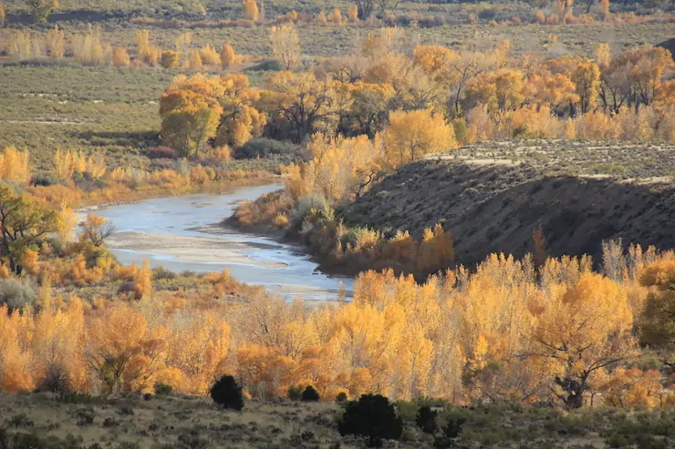
Rio Grande levy near Alamosa, November 2024. Photo credit: The Alamosa Citizen
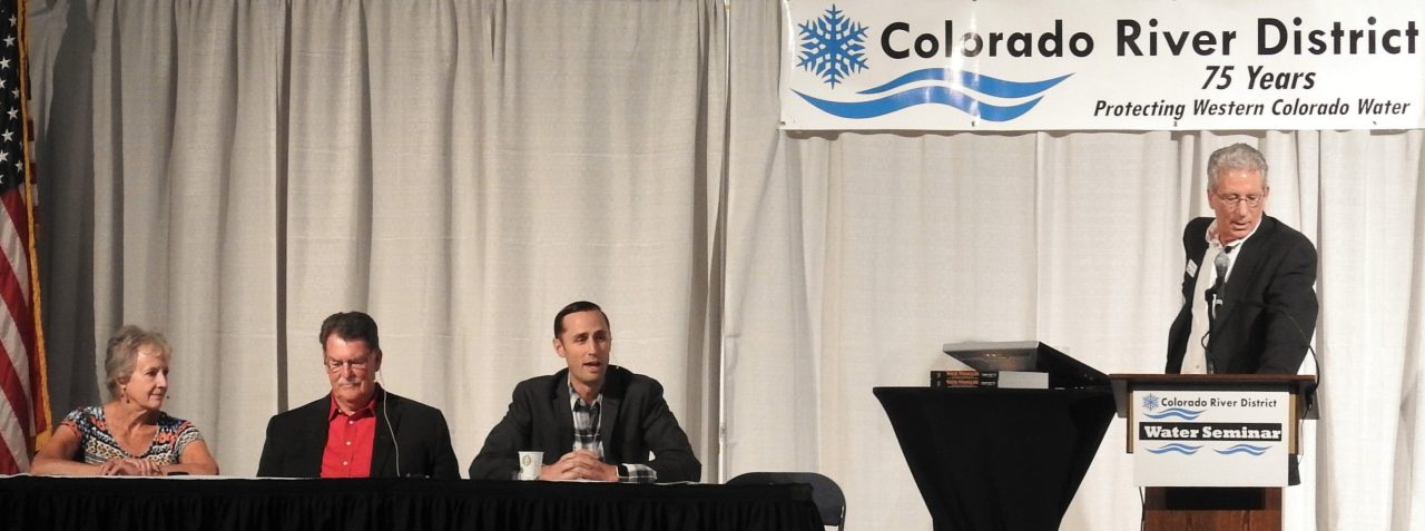
The theme this year was “Where Water Connects Us: Past Meets Present in the San Luis Valley”. Paul Formisano and the staff and volunteers from the Salazar Rio Grande del Norte Center delivered a varied, timely and interesting agenda!
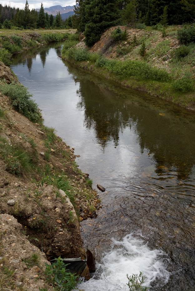
San Luis People’s Ditch March 17, 2018. Photo credit: Greg Hobbs
Ken Salazar set the stage for the sessions, reminding attendees that, “Early settlers knew the only way to bring prosperity to the valley was to do it collectively as the early acequias did.”
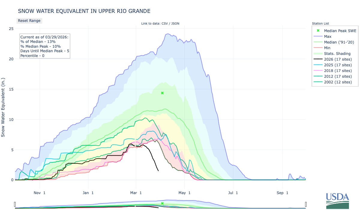
Upper Rio Grande snowpack March 29, 2026. Credit: NRCS
The first session was titled, “State of the Rio: The 2026 river outlook general basin and compact projections” and the general consensus from the speakers was, as Brad Udall recently said about the Upper Colorado River Basin, “There is no historical analog,” for these conditions. Snow drought is front and center in the San Luis Valley these days.
Upper Rio Grande accumulated precipitation March 29, 2026. Credit: NRCS
Precipitation in the basin started out the water year in great shape due to a big rain event in early October. Since then there have been modest accumulations but has flattened out since late February to date.
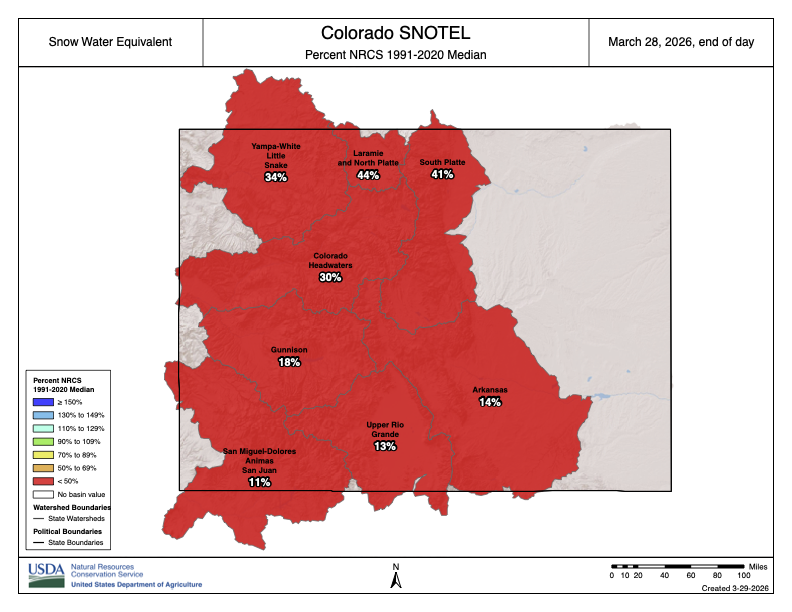
Colorado SNOTEL basin-filled snowpack map March 28, 2026. Credit: NRCS
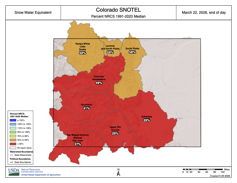
Division Engineer Craig Cotten started off his presentation with the basin-filled snowpack map for Colorado. He joked that, “The good news is, the Rio Grande is not the worst in the state.” It is not a good year as far as #snowpack and many SNOTEL locations are already melted-out.
Slide credit: Craig Cotten
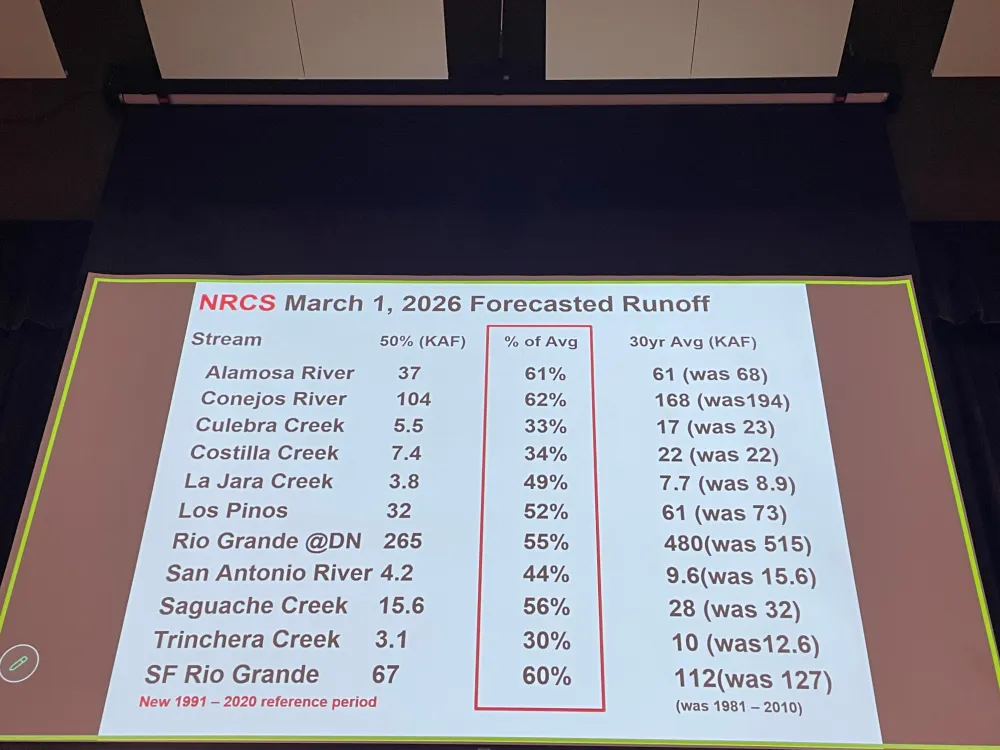
Projected streamflow is not looking good and the forecast will likely be worse when the April 1, 2026 numbers are released by the NRCS. However, streamflow right now is looking okay, there is a lot of water in the #RioGrande at this time for example. That means that the little snowpack in the basin is already coming off.
Slide credit: Craig Cotten
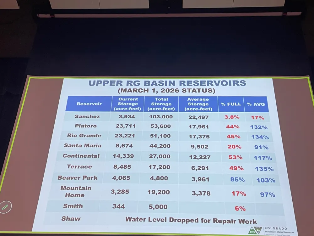
Reservoir storage is in good shape (as a percent of average) except Sanchez Reservoir which has been drawn down for maintenance and repairs.
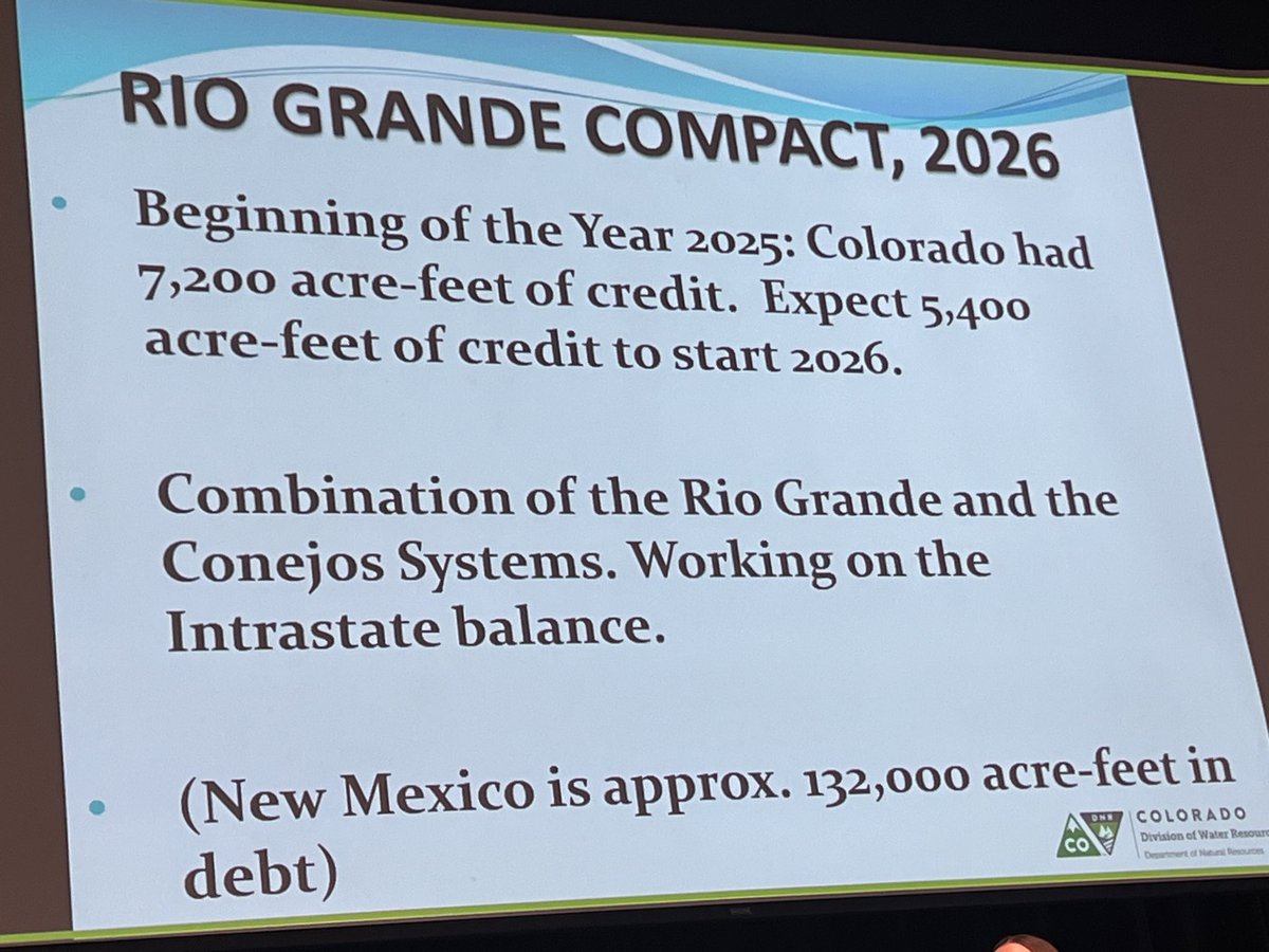
Current compliance numbers for the Rio Grande Compact from Craig Cotten. Photo credit: Chris Lopez/Alamosa Citizen
Colorado’s Rio Grande Compact compliance numbers heading into the scary diversion season are a positive. There is no debt owed to New Mexico and Texas. With the early onset to runoff season the State Engineer allowed irrigation to start on March 23, 2026. Current estimated streamflow for the Rio Grande at Del Norte (the compact USGS gage used for the river) is 305,000 acre-feet which carries a compact obligation of 76,000 acre-feet to New Mexico and Texas. For the Conejos River the estimated upper index annual flow is 165,000 acre-feet and the downstream obligation is 27,500 acre-feet. However, water levels are going to drop in the unconfined aquifer significantly this year due to low flows in the river. The situation in the aquifer is bad and it is going to get worse.
Cotten updated the attendees about the Rio Grande Compact lawsuit status. It is mostly a fight between Texas and New Mexico and the latest stipulated agreement has been approved by the Special Master. The U.S. Supreme Court is expected to approve the agreement.
Nathan Coombs, in keepting with the symposium theme said, “I believe we’re going to be alright this season we’re going to survive. People in the San Luis Valley are working together and we’re going to get through it.”
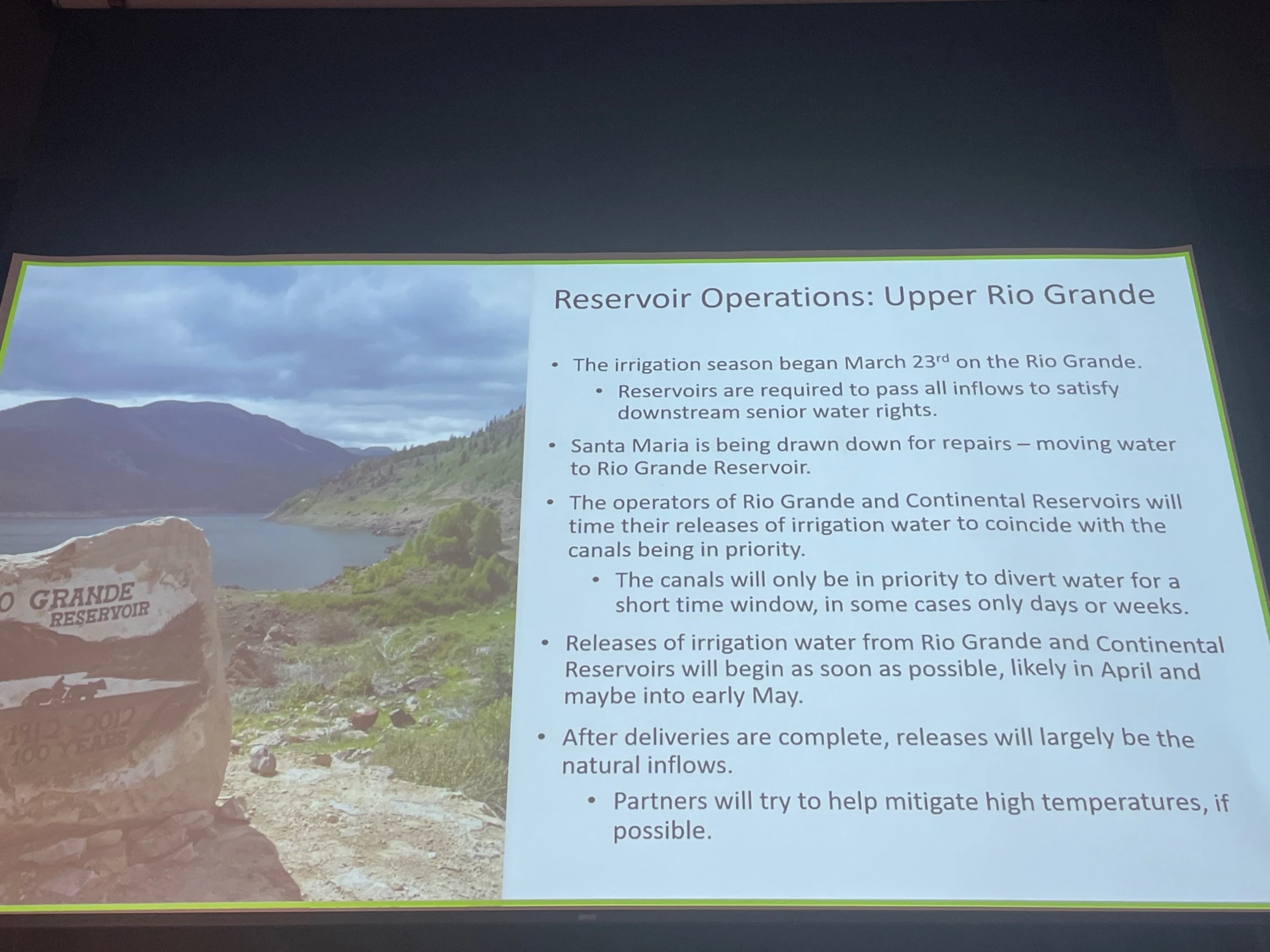
Slide credit: Heather Dutton
Heather Dutton gave an overview of reservoir operations for 2026. It is possible that all irrigation water will be released in April and May. She added, “If you’re going to fish the streams emphasize fishing in the morning and visit one of our valley breweries in the afternoon. It’s going to be tough year for all of us. Please keep the farmers in mind.”
Reclamation informed attendees about the current status of the Closed Basin Project. Project priorities are:
Colorado’s compact deliveries
Mitigation for construction and pumping
Eliminate Colorado’s Rio Grande Compact deficit
Other beneficial uses/irrigation
Slide from Amber Pacheco
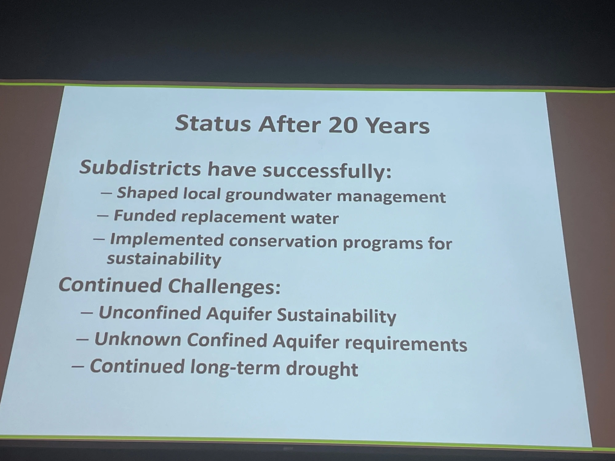
The session “Twenty years of subdistricts” illustrated how the well owners have been working together over the years to determine a solution to the declining unconfined aquifer. Because groundwater is not separate from surface water the lowered levels in the aquifer affect surface streamflow in the Rio Grande. Valley pumpers have formed several sub-districts fashioned around the different hydrology in areas of the aquifer and are retiring some wells and taking land out of production. Another strategy used has been o develop augmentation plans to offset pumping. All of the strategies involve fees to sub-district members. There is extensive coverage of the issue on Coyote Gulch if you are interested in taking a trip down memory lane.
Slide credit: Rachel James
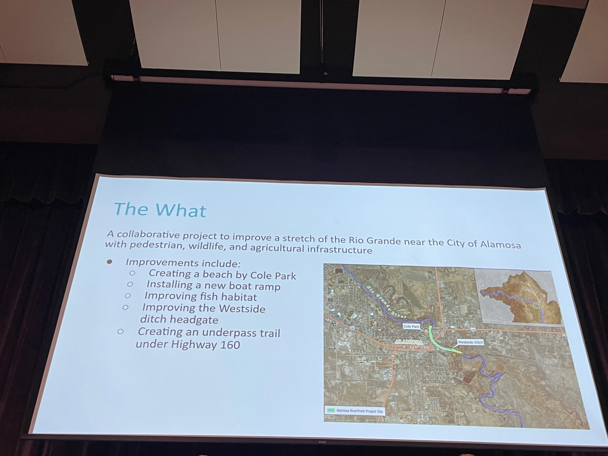
The session “Flowing together: Agriculture, rivers, and communities in partnership” was an overview of collaboration between the City of Alamosa, the West Side Ditch, and Rio Grande Headwaters Restoration Project on the river at the east side of Alamosa. It included a new headgate for the ditch company and will include a new levy orientation and access to the river from Cole Park. The speakers emphasized that it would not have happened without collaboration and the emphasis on creating a win for all stakeholders. For example, Bill Schoen credited the Rio Grande Headwaters Restoration Project for finding funding for the new headgate which is often a problem for mutual ditch companies. Daniel Boyes of the Restoration Project said that the new headgate helps fish and safety for boaters.
Rio Grande, Colorado | National Park Service
The final session before the keynote was “Perspectives on valley recreation” where access to public lands and the value of building a recreation economy to bolster valley opportunities were discussed. While 39% of Colorado’s agricultural output is from the valley economic activity is seasonal. The discussion centered around bringing tourism to the valley to improve the outlook for employment and economic growth.
The keynote speaker was Ben Golfarb and it was a real treat. I never tire of learning about “Nature’s Engineers” and the amazing effect this keystone species has on hydrology and habitat. Trapped extensively by fur traders to enable the fashion industry in the 19th century the species was nearly extirpated from the North American West. Along with a torrent of information and photographs, Goldfarb informed attendees that the native tribes did not participate in trapping because of their understanding of beaver’s role in the arid lands.
Rio Grande and Pecos River basins. Map credit: By Kmusser – Own work, Elevation data from SRTM, drainage basin from GTOPO [1], U.S. stream from the National Atlas [2], all other features from Vector Map., CC BY-SA 3.0, https://commons.wikimedia.org/w/index.php?curid=11218868
River managers need to conserve around 1.7 million acre-feet in Lake Powell to keep the reservoir from dropping below hydropower turbines this year, according to federal government projections. The Bureau of Reclamation, a federal agency that manages dams on the Colorado River, has estimated that reservoir levels could fall below required elevations for hydropower production before August as record-low snowpack turns into pitiful flows in streams and rivers.
“The situation is dire, the stakes have never been higher, and the reservoirs have never been drier,” Estevan Lopez, New Mexico’s negotiator on interstate Colorado River matters, said during a meeting of the Upper Colorado River Commission on Tuesday [March 24, 2026].
The back of Glen Canyon Dam circa 1964, not long after the reservoir had begun filling up. Here the water level is above dead pool, meaning water can be released via the river outlets, but it is below minimum power pool, so water cannot yet enter the penstocks to generate electricity. Bureau of Reclamation photo. Annotations: Jonathan P. Thompson
If water levels fall below required levels for hydropower production, dam managers will be forced to release water through bypass tubes, which are not designed for sustained, high-volume flows. With too much use, the bypasses could fail, turning the dam into a massive plug in the river and shutting off downstream flows. To keep Powell above those critical levels, federal officials can either fill it with water from upstream reservoirs, including some in Colorado, or they can reduce the water it drains from Powell and sends to the Lower Basin (California, Arizona and New Mexico). States are already expressing their views on how those operations should work. Upper Colorado River basin states, including Colorado, want the federal government to achieve the conservation requirement by reducing water releases to downstream states, at least in part. Upper Basin states say upstream reservoirs aren’t enough to save Powell without cuts to Lower Basin water deliveries. Draining the upstream reservoirs could also leave the system without backup supplies in the event of another dry year…The three primary reservoirs that could prop up Powell are Flaming Gorge in Wyoming, Navajo Reservoir in New Mexico, and Blue Mesa Reservoir near Gunnison, Colorado. Of the three, only Flaming Gorge is large enough to contribute the entire 1.7 million acre-feet on its own, and that would require draining the reservoir to halfway full. Blue Mesa and Navajo already stand at around halfway full, and the two reservoirs likely could not provide the water to save Lake Powell even if both were entirely drained.
Colorado River “Beginnings”. Photo: Brent Gardner-Smith/Aspen Journalism
American White Pelican and Double-crested Cormorant at Bill Williams Wildlife Refuge along the Colorado River, Arizona. Photo: Gary Moore/Audubon Photography Awards
Click the link to read the article on the Audubon website (Jennifer Pitt):
March 20, 2026
Audubon and partners cut through the conflict with a unique, basinwide perspective, championing the river’s health for the people and birds that rely on it.
The winter of 2025-2026 has not been kind to the Colorado River. Record-warm temperatures day after day across the mountains that feed the river have led to record-low snow levels. All indications are that spring snowmelt feeding the river will be scant.
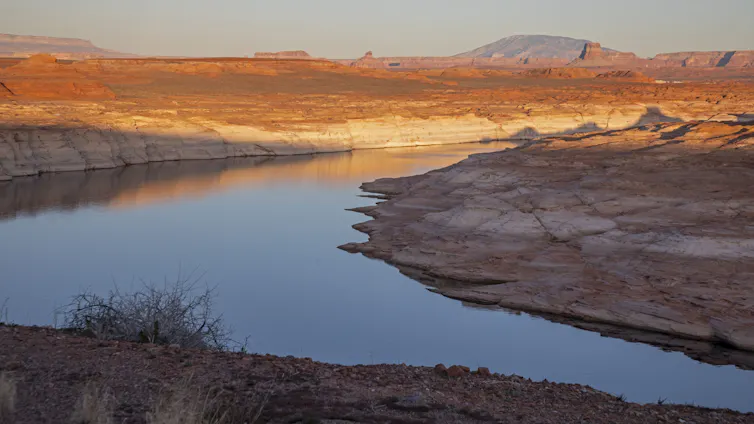
That is a huge problem, because Colorado River reservoirs, which historically held vast water reserves, are already depleted, with Lake Powell at 25% and Lake Mead at 34% of capacity. This is bad news for people and birds relying on water from the Colorado River. The U.S. Bureau of Reclamation (Reclamation), the federal agency managing the dams, projects that Lake Powell’s water levels could fall low enough to threaten Glen Canyon Dam’s infrastructure, downstream water delivery, hydropower, and native wildlife in the Grand Canyon including the California Condor and the Western Yellow-billed Cuckoo, among others.
As this crisis plays out, Reclamation has the difficult job of re-tooling systemwide, long-term dam operations on the Colorado River (often referred to as the “Post-2026 Guidelines”). Existing rules, first set nearly two decades ago and tweaked repeatedly to keep up with the declining Colorado River (the result of a warmer and drier climate), expire at the end of this year. As anticipated under this timeline, Reclamation issued a Draft Environmental Impact Statement (Draft EIS) in late January which laid out potential alternatives for federal management and solicited comments from stakeholders. This Draft EIS embraced uncertainty as a central planning condition as they tested different approaches under a broad range of hydrologic conditions. For a long time, the expectation was that the seven U.S. states sharing the river (Arizona, California, Colorado, New Mexico, Nevada, Utah and Wyoming) would develop a consensus-based proposal for Reclamation, but that hasn’t happened and talk of litigation has increased.
Southwestern Willow flycatcher
Reclamation must now figure out next steps. The agency does have legal authorities, but those legal authorities were crafted long ago and do not necessarily spell out how to take meaningful action in this historic crisis. That threatens the water supply for more than 35 million people including the major cities of the American Southwest, Tribes, millions of acres of irrigated farms and ranches, as well as the Colorado River itself and every living thing that depends on its habitats, including hundreds of bird species like the Southwestern Willow Flycatcher, Yuma Ridgway’s Rail, and Summer Tanager.
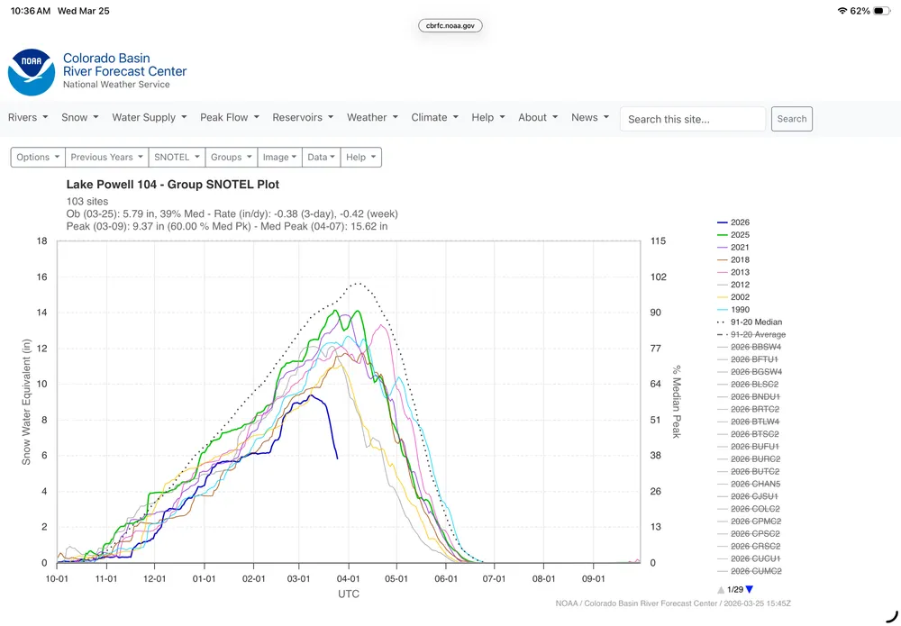
This is a graph of snowpack above LakePowell using 104 snow measuring stations. It was 9 inches of water on March 7, now 6 inches. Other dry years shown.There is no historical analog to this — Brad Udall
Audubon submitted formal comments in response to the Draft EIS, joining conservation partners to weigh in on what comes next for Reclamation’s consideration (read our comment letter here). Dozens of comments were submitted by the Colorado River Basin states, water users, and other stakeholders making their case with Reclamation that their water uses need to be protected at the expense of others. In its comments Audubon emphasized the need to stabilize the Colorado River system from its headwaters to its delta—a unique, basinwide perspective that urges Reclamation to manage risks for people and nature rather than deferring hard decisions until emergency conditions force action. Our comment letter focused on constructive engagement noting the Draft EIS’s strengths in its analytical foundation while identifying and describing targeted refinements that would help ensure the Final EIS fully informs decision-makers about risks and real-world consequences. Specifically, Audubon calls for:
Clarity and predictability
Flexible, adaptive tools for conserving, storing, and managing water
Environmental stewardship embedded into operations
Meaningful and voluntary Tribal participation
Pathways for advancing in-basin mitigation and resilience-building opportunities
Pathways for advancingbinational cooperation with Mexico
Over the next few months, Reclamation still has an opportunity to persuade the Colorado River Basin states into consensus. Whether or not they are successful (and we hope they are), sometime this summer we expect Reclamation to issue a Final EIS that includes refinements to the Draft as well as an indication of their preferred alternative for Colorado River operations. In the meantime, it is urgent Reclamation also prepare for the water supply emergency that is unfolding in 2026.
For much of the last century, Reclamation was a leader in developing the southwestern United States by harnessing the Colorado River and delivering its water across the land. Today, Reclamation must lead in a new way, helping everyone and everything that depends on the Colorado River live with the river we have in a warmer, drier world.
Lake Dillon, a reservoir in Colorado’s Summit County, is owned and managed by Denver Water and supplies water to people living in Metro Denver. It is Denver Water’s largest reservoir and provides about 40% of Metro Denver water. A 23-mile-long trans-basin diversion pipeline, called the Harold D. Roberts Tunnel, carries water from the reservoir under the Continental Divide to Denver. Photo credit: Colorado State University
Each day during the winter and spring, one of the first things I look at is the U.S. Department of Agriculture’s website that shows the current status of the snowpack in Colorado’s mountains.
Maybe that sounds like the strange habit of a state climatologist, but I’m far from the only one. Why? Because the snow that falls in our state’s mountains will, when it melts in the spring and summer, become a large portion of the water supply for tens of millions of people.
Those people aren’t only here in Colorado, but are in other states, Tribal nations, and Mexico, drawing their water from the rivers that originate in Colorado. Mountain snow is essential for our winter recreation industry, for farms and ranches that grow our food, for drinking water, for ecosystem health, and much more.
It hasn’t been a pretty sight when I have opened that USDA website each morning this winter. In an average year, our mountains get a lot of snow: In places like the Park Range, the West Elk Mountains or the San Juans, a typical year brings hundreds of inches of snow, carrying more than 40 inches of liquid water. This year, we struggled to get half that. Now, after an unprecedented heat wave in March, the snow is already disappearing quickly.
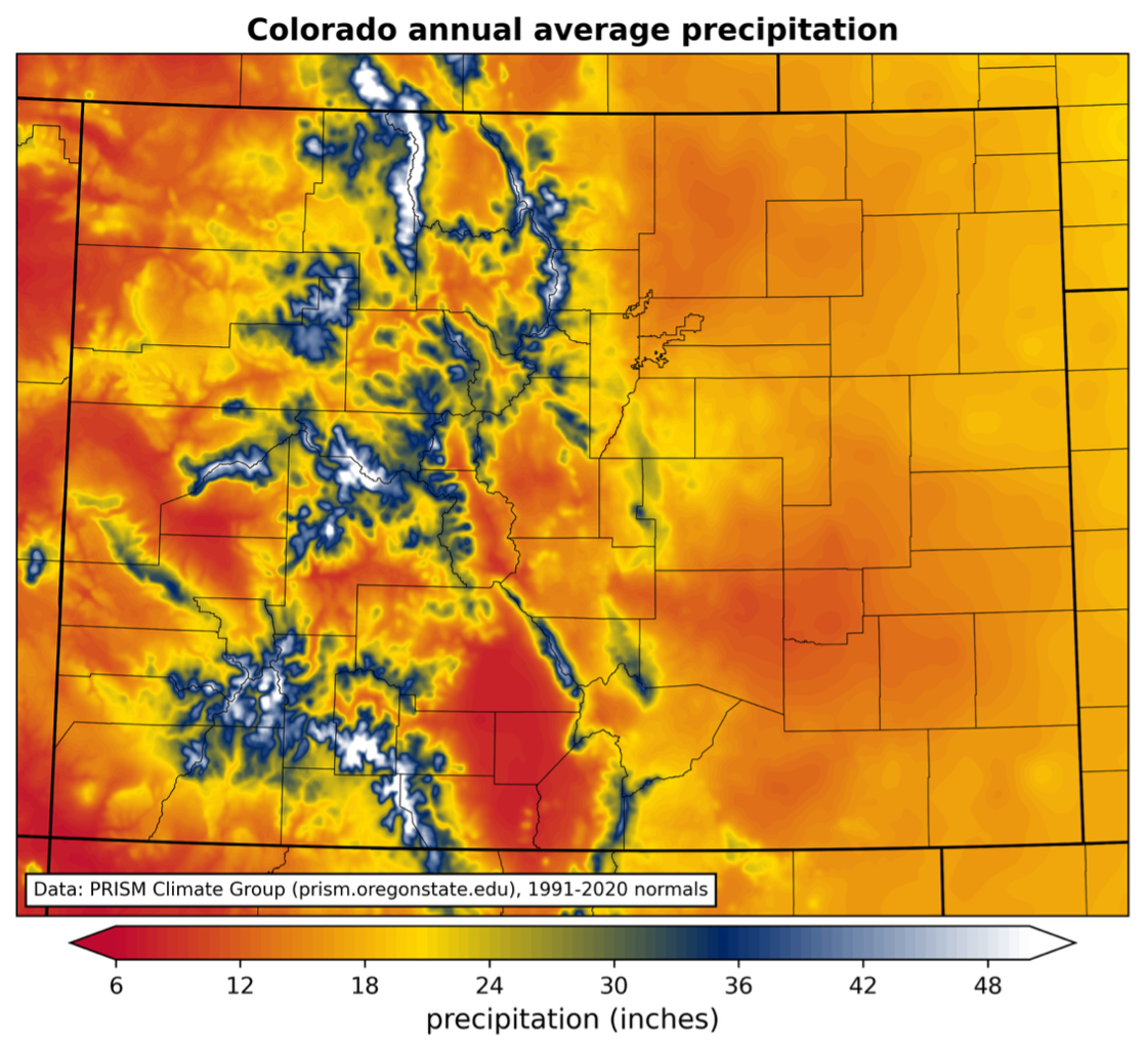
Figure 1: Map of annual average precipitation over 1991-2020 in Colorado, with color scale matching the colors in the state flag. Data from the PRISM Climate Group. Credit: Colorado Climate Center
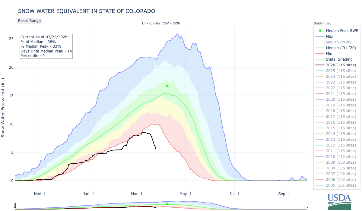
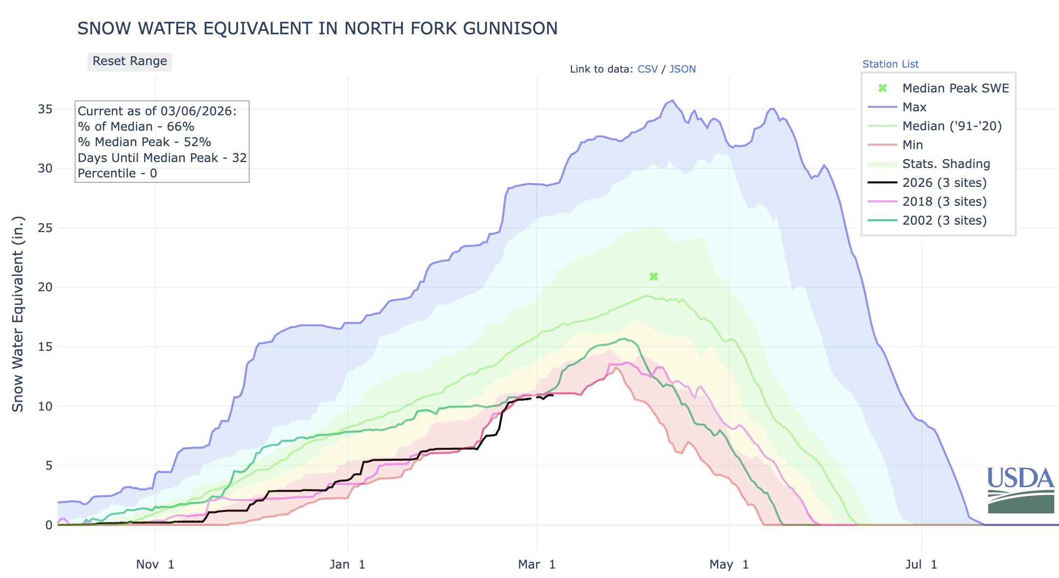
As of March 25, averaged across 115 stations in Colorado’s mountains, the snow water equivalent was just 38% of the 1991-2020 average. (The snow water equivalent is the amount of water stored in the snowpack.) This represents the lowest snowpack in more than 40 years – and possibly ever – in Colorado’s mountains. Conditions haven’t been any better along the Front Range and Eastern Plains, which have also lagged far behind the average amount of snowfall.
Figure 2: Statewide snow water equivalent from the SNOTEL network, as of March 25, 2026. The median over 1991-2020 is shown with the green line, the historical range is shown from red (low) to blue (high), and this year is shown in the black line. From USDA/NRCS.
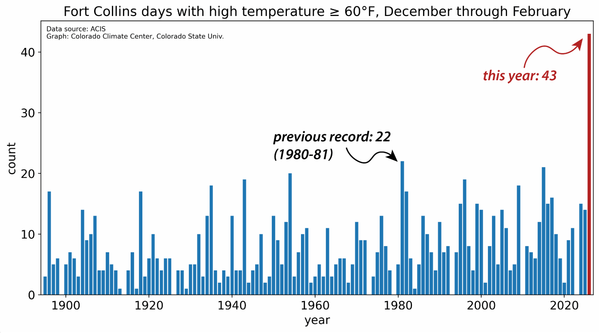
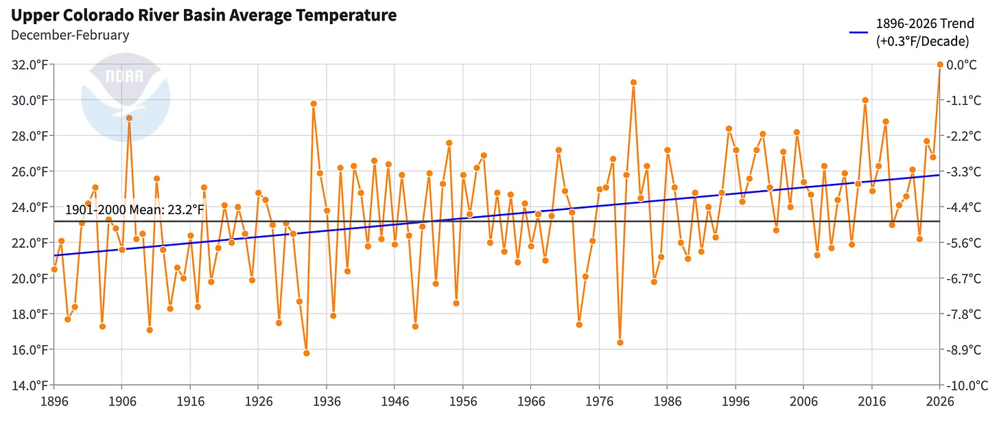
There have been other major snow droughts in the past, notably the winters of 1976-1977 and 1980-1981, that threatened the ski industry and resulted in record-low streamflow on some of Colorado’s rivers. But this snow season has been unrivaled in its warmth. The first five months of the water year – from October through February – were Colorado’s warmest on record by a large margin. And it’s almost certain that we are in the midst of the warmest March on record as well.
The warmth has been remarkably persistent, as relentless ridges of high pressure have prevented the usual snowstorms from moving into the state. The Fort Collins weather station at Colorado State University recorded an astonishing 43 days with a high temperature of 60°F or above during climatological winter (December through February). The previous record, from records dating back to the late 19th century, was 22. Starting March 18, Fort Collins had temperatures higher than had ever been observed in March, four days in a row. This was capped by a high of 91°F on March 21; there had never previously been a 90-degree day in Fort Collins before May.
Figure 3: Number of winter days with high temperatures of 60°F or above at the official Fort Collins weather station on the CSU campus. Winter 2025-2026 had 43 days, far more than the previous record of 22 in 1980-1981. Credit: Colorado Climate Center
Records for March were smashed across the state and the western U.S., at both low and high elevations. One thing we do as state climatologists is put current conditions into historical context, as usually with some investigation, it’s possible to find a past analog to what we’re experiencing now. But the intense and prolonged heat has been unlike anything previously observed in March.
This, of course, is occurring in the context of a long-term trend toward warmer conditions, both globally and locally, largely attributable to increases in greenhouse gases. Per data from the National Oceanic and Atmospheric Administration, nine of the 11 warmest years in Colorado records have occurred since 2012, and Colorado has now warmed by 3°F since the 1890s. Droughts come and go, and they have always been a challenge in Colorado and the West. But warming is making them more likely and more intense. In other words, climate change is water change.
When above-average temperatures and precipitation deficits stack up over the course of months, we start to see drought conditions develop or worsen. The impacts of drought are wide-ranging and include economic and agricultural repercussions. Farmers and ranchers may face lower crop yields and higher costs of feeding livestock. A snow drought like this winter’s can reduce outdoor recreation opportunities and hurt the state’s tourism industry. Drought years also tend to be years with more and larger wildfires.
Drought impacts can be felt a long distance from where the precipitation deficits occur. For example, southeastern Colorado received decent precipitation this winter, but low snow in the mountains hundreds of miles away near Leadville means less water on the Arkansas River, an important source for farmers in southeastern Colorado.
As each winter progresses, even if the mountain snowpack isn’t looking great, we can always look ahead to March and April as the time when big storms are possible and the deficits can be made up. Unfortunately, this year has been just the opposite: Instead of much-needed snowstorms, we’re in an unprecedented March heat wave that is accelerating the melting of what little snow is there. The chances of getting back into the range of average have dwindled away, and if the weather pattern doesn’t turn around in April, we may be headed for uncharted territory for Colorado water.
The sun rises over Lake Powell in Glen Canyon National Recreation Area, in Page, Arizona. Lake Powell, a critical Colorado River reservoir, is only at a third of its capacity as drought conditions in the Southwest worsen. CREDIT: ECOFLIGHT
Click the link to read the article on the AZMirror website (Caitlin Sievers):
March 23, 2026
Arizona is preparing for a legal battle over its rights to Colorado River water.
Following an extraordinarily dry winter along the river basin and what’s expected to be an exceptionally hot and dry spring across the West, where high temperatures in March have already blown past records, the pressure to maintain access to the state’s fair share of river water is growing.
The Colorado River is a vital source of drinking water for 40 million people in the seven basin states, Mexico and 30 Native American tribes, and provides water for farming operations and hydroelectricity.
Reaching a water usage agreement is imperative to the basin states as the river’s water supply continues to decline, as it has done for the past 25 years due to a persistent drought spurred on by climate change.
On Monday, the Arizona Governor’s Office announced that it had retained the law firm Sullivan & Cromwell to represent the state in possible litigation among the Colorado River Basin states and the federal government.
Sullivan & Cromwell is an international firm based in New York City that has represented big names like Microsoft, BP, Goldman Sachs and JPMorgan Chase. The state is using some of the $3 million it put into its Colorado River legal defense fund last year to retain the law firm.
The Governor’s Office doesn’t expect to take any legal action until June at the earliest, but wants to be prepared for the possibility, especially if the dispute ends up before the U.S. Supreme Court.
The Lower Basin states — Arizona, Nevada and California — and the Upper Basin states — Colorado, New Mexico, Utah, and Wyoming — have been negotiating an updated water usage agreement for more than two years.
But so far the states have blown past two deadlines to do so — one in November and one in February — and are quickly approaching October, when the existing usage agreement expires.
If the states can’t reach an agreement before that, the federal government will implement one of its draft plans, all of which would place an outsized burden on the Grand Canyon State.
That’s because the Central Arizona Project, a series of canals that supplies Colorado River water to the Valley and the Tucson area, is one of the newest users of the river water, making it legally one of the first to be cut.
But so far, the Upper Basin states have refused to agree to any water usage cuts of their own, while the Lower Basin states insist that every state take their fair share.
Arizona has offered to reduce its Colorado River allocation by 27%, California by 10%, and Nevada by nearly 17%.
Negotiators for Arizona also insist that the Upper Basin states be held to the original 1922 Colorado River Compact that requires them to release a 10-year rolling average of at least 75 million acre-feet of water to the Lower Basin, in addition to one-half of the annual allotment owed to Mexico, for a total of about 80.2 million acre-feet.
An acre-foot of water represents enough to cover an acre of land to a depth of one foot, or about 325,851 gallons. That’s enough to provide three homes in Arizona a year of water, on average.
So far, the Upper Basin states have held to the original release agreement. But as water levels in the two major reservoirs on the river, Lake Mead and Lake Powell, continue to decline, it’s expected that the Upper Basin states will be unable to meet that requirement as early as 2027.
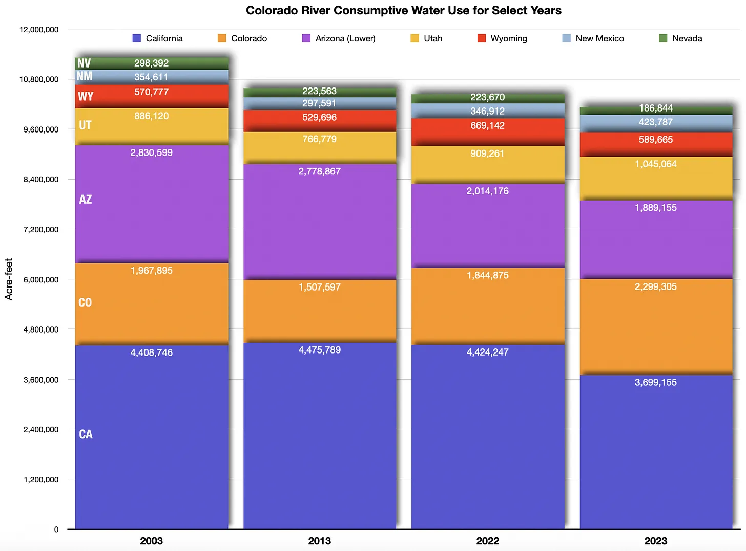
When the states entered into the original Colorado River Compact in 1922, they allocated 7.5 million acre-feet of water each year to be shared by the Upper Basin states and another 7.5 million to be used among the Lower Basin states.
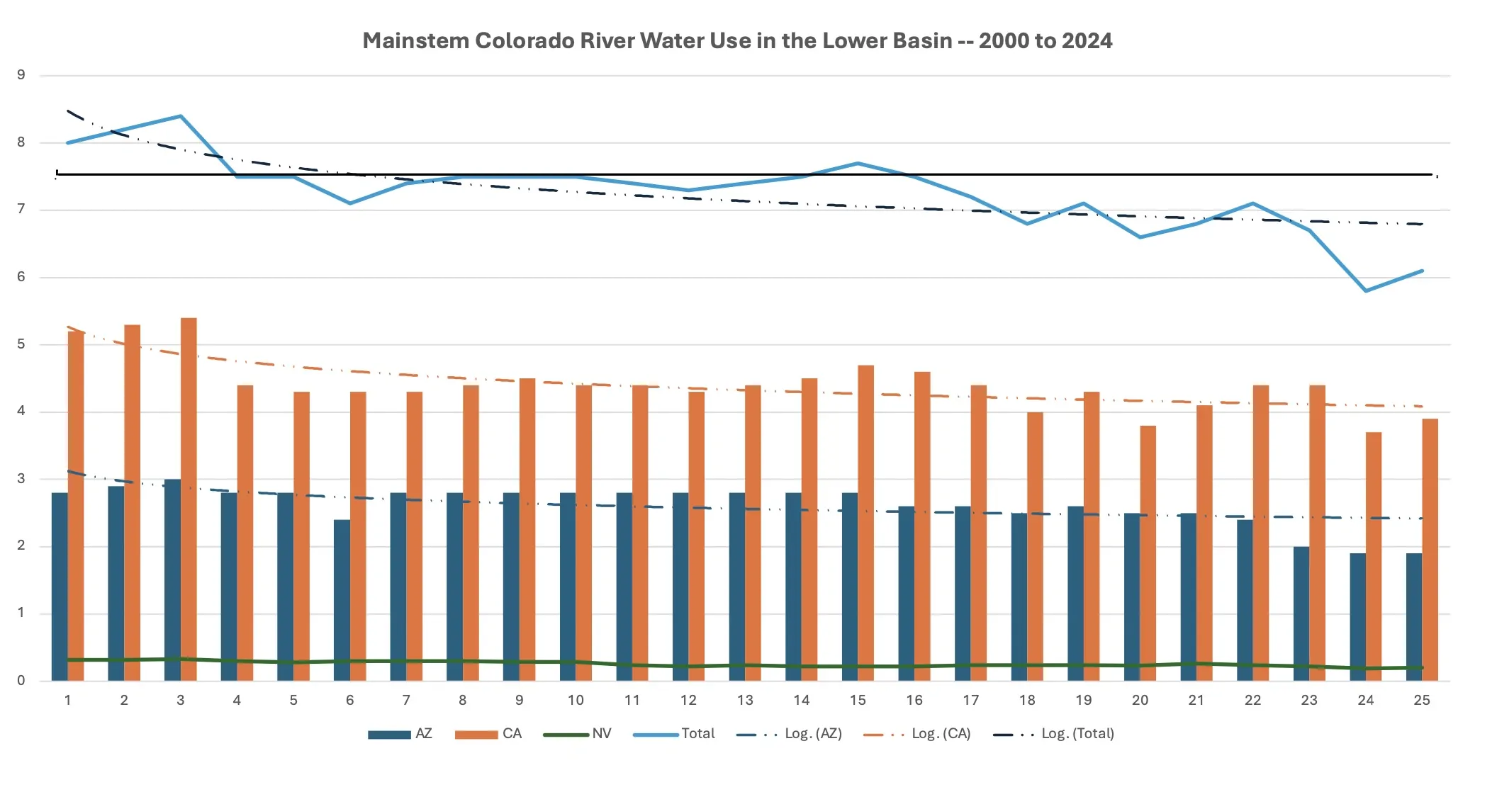
Since then, the states have updated their water usage guidelines several times, even though the apportionments remain the same. But Lower Basin states face mandatory cuts during times of drought and Upper Basin states do not. In 2025, for the fifth year in a row, the federal government imposed drought-based cuts, and Arizona’s amounted to a loss of 512,000 acre-feet of water for the year.
Under current allocations, Arizona has rights to 2.8 million acre feet of water per year, and has implemented 800,000 acre feet in reductions per year. In contrast, Colorado has rights to 3.8 million acre feet a year, although it uses an average of 1.9 million acre feet, annually.
The amount of water that Colorado has access to can be unpredictable because it relies mostly on melted snowpack for its water, which varies from year to year. This year’s snowpack levels are historically low.
The Lower Basin states have undertaken significant conservation efforts for Colorado River water since 2014 and have reduced their consumption from 7.4 million acre-feet in 2015 to just over 6 million in 2024.
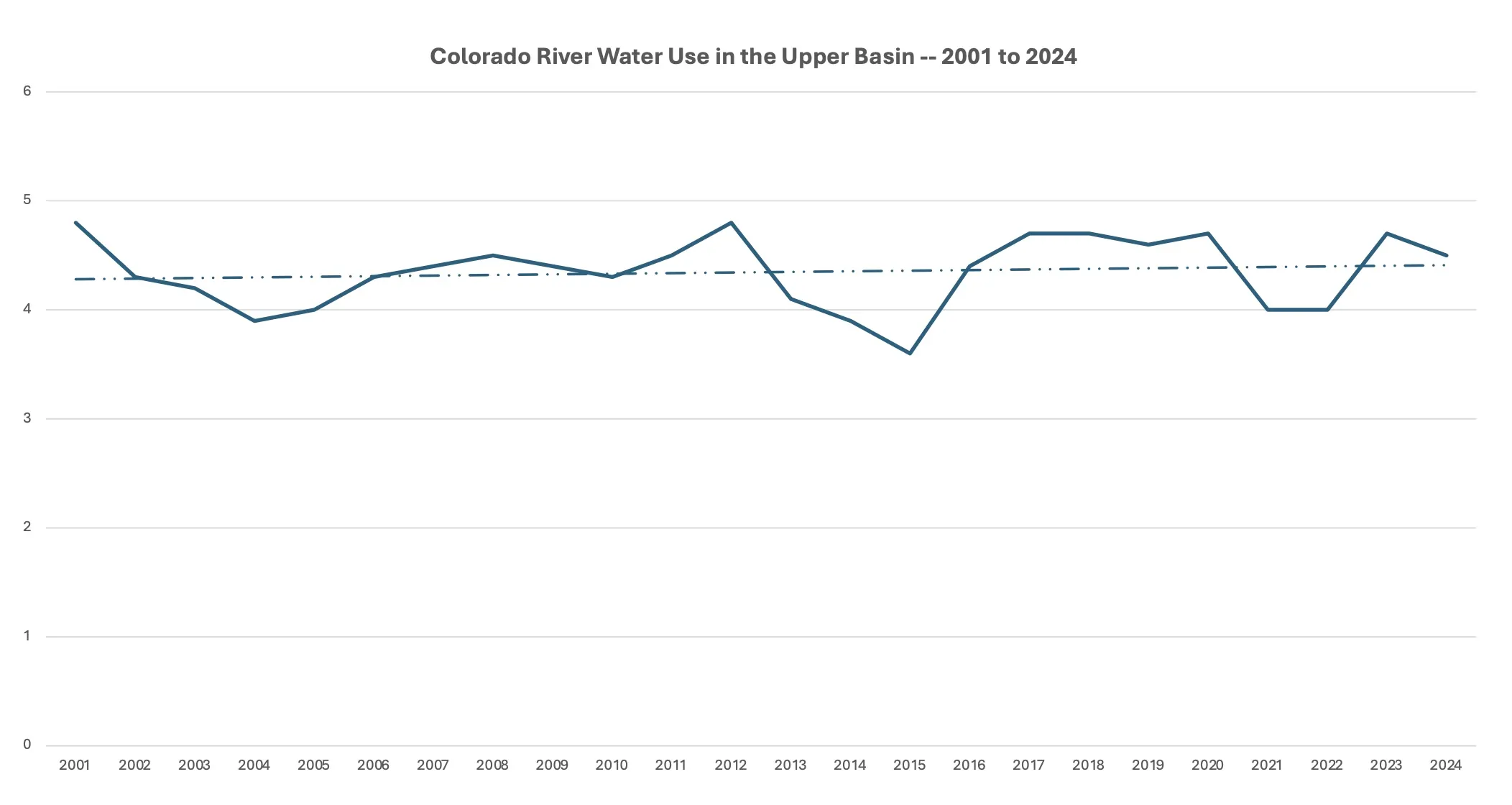
The Upper Basin states have increased their usage in the past five years, from 3.9 million acre-feet in 2021 to 4.4 million in 2024. The federal government’s draft plans allow for the Upper Basin states to use even more water.
Gov. Katie Hobbs’s proposed budget for this year would put another $1 million toward the Colorado River Legal Defense fund, and lawmakers earlier this month gave preliminary approval to doing just that.
Even as Arizona prepares for a legal battle, the state plans to continue attempting to reach an agreement with the other river basin states, according to the Governor’s Office.
“Governor Hobbs is committed to working with the federal government and other Colorado River states to deliver a negotiated settlement that protects Arizona’s fair share of water and stabilizes the system,” spokesman for Hobbs Christian Slater said. “However, it’s critical that Arizona be prepared to defend ourselves in court if an agreement cannot be reached or the Law of the River is violated.”
Click the link to read the article on the InkStain website (John Fleck):
March 18, 2026
Some notes on the current state of the Colorado River…
I’m preparing for a panel discussion this evening in Albuquerque. I promised – three-finger promise, Scout’s honor, which still means something to me – that I wouldn’t use any swear words., either in the blog post or the panel discussion.
The state of the water
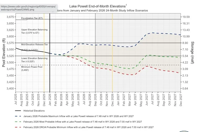
Per the latest numbers from my colleague/collaborator/friend Jack Schmidt, Lake Powell currently holds 1.57 million acre feet of water above the protect-the-infrastructure no-go line of elevation 3,500.
Storage at this point in the year is similar to 2022, when we began a hair-about-to-be-on-fire drill as Interior raced to figure out how to protect Glen Canyon Dam because of newly understood (or newly publicly understood) risks of dropping below minimum power pool and using the dam’s outlook works. That constraint still holds.
The forecast this year is a catastrophe compared to 2022: 1.75 million acre feet for the 2026 runoff season, compared to 3.8 maf in the 2022 runoff season. [ed. emphasis mine]
The result, according to the most probable forecast from Reclamation, is that absent some sort of action (see governance below) Powell will drop below 3,500 in September, and stay that way until the spring runoff in 2027.
According to the min probable forecast, which is realistic given the looming heat-pocalypse, we hit 3,500 by July and stay there forever (by which I mean as far as the current 24-month forecast runs – as the late Jim Morison wrote, the future’s uncertain and the end is always near).
The state of the governance
The state of the governance nests two separate by closely linked problems: near term actions and long term rules.
Near term actions
Protecting Glen Canyon Dam from that 3,500 no-go line requires coming up with a least 2 million acre feet of water over the next two years – to get us past that spring 2027 problem described above. There are two ways to do this. The first is to release a bunch of water from upstream, primarily Flaming Gorge Reservoir. How much? Dunno. The second is to cut releases from Glen Canyon Dam, reducing flows through the Grand Canyon and into Lake Mead. How much? Dunno, though we may find out soon.
The current rules, adopted in response to the challenges of 2022-23, allows releases from Glen Canyon Dam to drop this year to 6 million acre feet, which effectively gets 1.5 million of the needed 2 million feet from Lake Mead by reducing releases thereto. Another 500,000 in releases from upstream reservoir gets you 2 million acre feet, with room to do more if the hydrology gets even worse – which it might.
Longer term actions
The longer term stuff is where, as a student of governance, this gets really interesting for me. As a citizen of the basin, I am inclined to swear words at the dysfunction that has left us with no long term plan beyond the end of this year. But I Scout’s honor promised, so shifting to the “student of governance” schtick gives me a view from nowhereway to approach this dispassionately, without the, y’know, words that would have made Mr. Vinatieri, my Scoutmaster, disappointed in me.
Others have chronicled the failure of the seven U.S. Colorado River Basin states to come to a consensus agreement on a set of river operating rules, we need not repeat that here, other than to note that what we have here is a classic case of what has been called the tragedy of the anticommons. This is a situation where many people or entities – in this case the states of the Colorado River Basin – each have the power to block a solution that might be to the benefit of the community as a whole. In this case, each of the seven states of the Colorado River Basin have blocking power over solutions that would prevent the reservoirs from crashing.
See above: the reservoirs are crashing and we have no plan to prevent it because any proposal that might prevent it has been blocked by one or more states that object.
The reason behind this is a set of rules written beginning in the 1920s governing the river – the Colorado River Compact and a series of ad hoc additions that followed – that attempted to lay out rules for managing the river but failed to include functional processes for modifying the rules when they proved inadequate to changing the situation. We’re now stuck with a system under which each of the seven basin states has blocking power over any attempt to change the rules.
This violates one of the fundamental institutional design principles identified by the late Elinor Ostrom, who taught us so much about how we succeed or fail in overcoming the tragedy of the commons: “How will the rules … be changed over time with changes in the performance of the resource system, the strategies of participants, and external opportunities and constraints?” We have to have rules about how we rewrite the rules. We lack that.
Despite this, we have succeeded in the past, in a series of rule-writing exercises that began in the late 1990s, by depending on principled actors at the state level recognizing that they needed to balance their need to protect their own community’s water supplies against the need to solve problems at the scale of the basin as a whole.
My personal values on this question are both instrumental (things that I think are in the best interests of myself and my community) and deontological (things that I think are fundamental moral principles). The second first: I think we have ethical obligations to those upstream and downstream of us in shared river basins. This is, for me, fundamental. The second is instrumental – I think compromise is in the best interests of my community’s water supply and therefore its future, because if we end up in litigation and the system crashes, we stand to lose a lot more than if we compromise, are willing to act on our obligations to our downstream neighbors by using less ourselves.
The last two years of increasingly hostile negotiations among the states make clear that behavior that recognizes those principles is gone, replaced by interpersonal bickering and a game of chicken driving the basin toward litigation (effectively hoping to manage the basin by convincing a judge of our preferred interpretation of ambiguous rules written a century ago) and reservoir collapse.
Thar be dragons.
Map of the Colorado River drainage basin, created using USGS data. By Shannon1 Creative Commons Attribution-Share Alike 4.0
Sunlight glimmers on the Colorado River near Page, Arizona on Nov. 2, 2022. Alex Hager/KUNC
Click the link to read the article on the KUNC website (Scott Franz):
March 20, 2026
This story is part of ongoing coverage of the Colorado River, produced by KUNC in Colorado and supported by the Walton Family Foundation. KUNC is solely responsible for its editorial coverage.
Critical negotiations about the future of the Colorado River took a two week hiatus last month after the seven states in the basin missed a key Valentine’s Day deadline for striking a deal, New Mexico’s water negotiator said Thursday.
Estevan López said talks resumed March 2, and the upper and lower basin states are using a short-term pitch from Nevada as a starting point.
“Right now, we’re in discussions with the lower basin about a potential short-term agreement,” Lopez told New Mexico’s Interstate Stream Commission.
Nevada is proposing to increase water releases from upper basin reservoirs like Flaming Gorge by at least 500,000 acre feet to help prevent Lake Powell from dropping too low.
The latest forecasts predict that Powell could drop enough to stop producing hydropower by December.
In return, lower basin states would agree to cut their water use by 1.25 million acre feet “until system conditions have meaningfully improved.”
López said upper basin states had a counter proposal and talks about it were scheduled on Thursday afternoon.
“The hydrology right now is incredibly dire,” López said. “So we’re beginning for this year, for the remainder of this water year, we’re suggesting that there needs to be a release from the upper initial units, most likely Flaming Gorge, since that’s the reservoir that’s largest and has the most water. And we are anticipating that there will be a release of half a million acre feet from Flaming Gorge to prop up Lake Powell.”
Meanwhile, the Interior Department is reviewing thousands of comments it received on a range of options for how to manage the vital waterway.
The alternatives were published in January and could result in a variety of scenarios, ranging from significant water reductions in lower basin states to creating new incentives for states to conserve water.
And after the states missed two deadlines to reach an agreement, it’s becoming increasingly likely the federal government will try to piece together its own plan before the current guidelines expire in the fall.
Water negotiators are also facing a worsening water supply forecast with record low snowpack across the West.
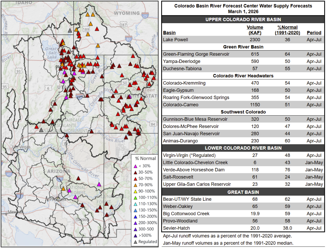
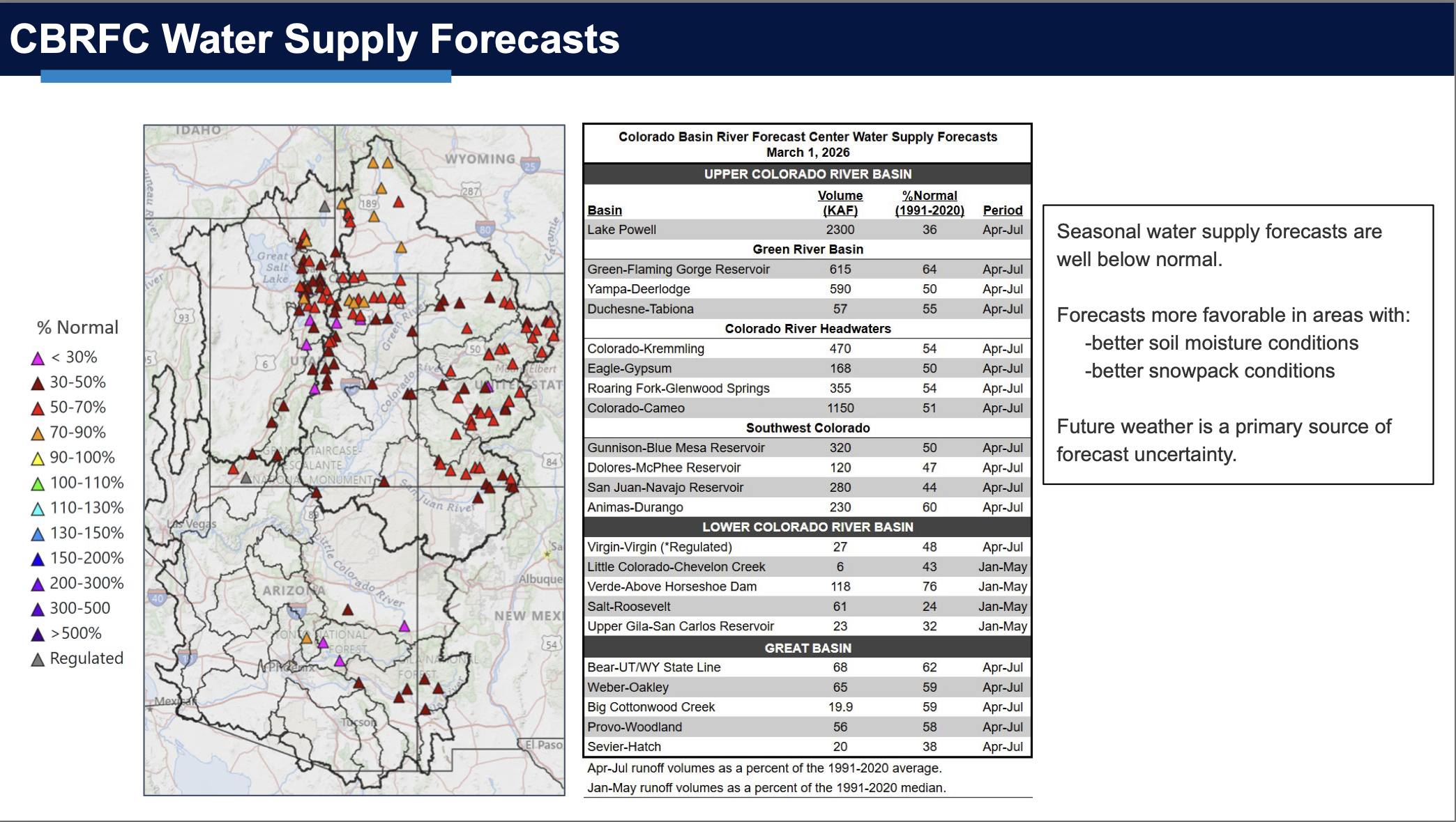
A map shows how much water is predicted to arrive at certain locations in the Colorado River basin as of a March 1 forecast.
Cody Moser with the federal Colorado Basin River Forecast Center said last week just 2.3 million acre feet of Colorado River water is expected to reach Lake Powell through July. That’s about a third of what’s considered normal.
“You’ll notice it’s not a pretty picture here with lots of reds,” he said as he presented a color coded map of how much water is expected to reach certain locations in the river basin. “That’s 50 to 70% of normal April through July runoff. Those maroon colors are 30 to 50% and we even have some of those pinks, which indicates less than 30% normal seasonal spring runoff.”
An attorney for New Mexico’s Interstate Stream Commission said Thursday the state expects the Interior Department to identify a preferred option for managing the dwindling river by July. The current operating guidelines for Lake Powell and Lake Mead expire in the fall.
The seven U.S. states that make up the Colorado River basin are struggling to agree on how best to manage the river’s water as its supply dwindles due to climate change and a period of prolonged drought. Their negotiations, which are not open to the public, missed a Feb. 14, 2026, deadline the federal government had established, after which federal officials said they would impose their own plan.
The federal government has not yet done so, but the prospect of such an action is not good news for the nearly 40 million people who depend on the Colorado River for water, energy, agriculture and recreation, nor for the estimated US$1.4 trillion in economic activity the river supports.
But compromise on Colorado River management is possible and, in fact, was achieved to curb California’s water use in the 2000s, to negotiate an interim agreement to coordinate operations at the Lake Mead and Lake Powell reservoirs in 2007, and to enact contingency plans to manage drought in 2019. But this time around, circumstances are different.
The negotiators for the states had long-standing relationships and built trust by frequently communicating outside formal meetings and seeking to listen to and understand other states’ perspectives, even if they didn’t agree.
The states also agreed to use the bureau’s computer model for analyzing scenarios of climate change and management decisions. That meant all the negotiators were looking at the same data when delving into possible options. And the political and social environment was less polarized than today.
The current situation
In this round of negotiations, federal leadership has been lagging. The Department of the Interior has not made clear what the consequences might be for the states if they fail to agree. The U.S. Bureau of Reclamation has been without a permanent commissioner since President Donald Trump retook office in January 2025.
The states are fractured into subgroups, according to whether they are in the river’s Upper Basin – Colorado, Wyoming, Utah and New Mexico – or the Lower Basin, which includes Arizona, Nevada and California. Each basin group holds strong positions and has generally been unwilling to shift.
Each basin group is using a different set of assumptions for the bureau’s computer model to explore options. And the discussion often gets stuck on details, which prevents progress toward broader agreements.
But those relatively new challenges to Colorado River compromise are not an excuse for failure.
Interior Secretary Doug Burgum, center between flags, meets with governors and representatives of the seven Colorado River basin states in January 2026. U.S. Department of the Interior via X
A way forward?
The current negotiations have all been done behind closed doors. From talking with people involved in the negotiations, we understand the negotiators have been left to set their own agendas and meeting plans and conduct their own communications and follow-up, with no formal facilitators.
It’s reasonable to expect the negotiators to be ready to represent their states’ interests, working through an incredibly complicated landscape of hydrology, climate and management scenario modeling, water law and administration, and politics. But we believe it’s unreasonable – and unrealistic and unfair – to expect them to also be experts at designing and facilitating an effective process for sorting out their differences.
Federal officials are not necessarily the best people to run the process either. And if the agency that ultimately needs to approve any deal is the one leading the process, real or perceived biases about the states or key issues in the agreement could further complicate the discussions.
We believe that agreement between the seven states is still possible. It may be less effective to bring in a third-party facilitator at this stage in the negotiation process, though, because of the degraded trust, hardened positions and shortage of time.
A more hopeful possibility is that the bureau adopts short-term rules that would give the states another chance to negotiate a longer-term deal – ideally with an unbiased third-party facilitator for support.
A collaborative and consensus-based planning process in the Yakima River Basin in Washington state in the early 2010s is evidence that while nobody gets everything they want in a negotiated agreement, “if they can (all) get something, that’s really the basis of the plan,” as a Washington state official told The New York Times.
Lake Powell, on the Colorado River, is seen from the air in 2019. The Upper Basin states are planning how to potentially fill a dedicated pool in the nation’s second largest reservoir. CREDIT: ECOFLIGHT
With a Lake Powell conservation pool nearly guaranteed for the future of Colorado River management, the four Upper Basin states are exploring and refining the ways they could fill it.
Conservation by those states (Colorado, New Mexico, Utah and Wyoming) could be one of the keys to reaching a deal among the seven states that share the Colorado River and an important part of the framework for managing the drought-stricken river after this year. The water saved by the Upper Basin states could be stored in Lake Powell as a means of maintaining higher water levels and as an insurance policy against drastic cuts.
This type of pool isn’t yet being used in Lake Powell; it would have to be established by an agreement among the seven states. An agreement in the 2019 Drought Contingency Plan allowed for a 500,000 acre-foot Upper Basin storage pool in Lake Powell, but so far, the states have not utilized this and the agreement expires this year.
The Upper Basin and Lower Basin (California, Arizona and Nevada) have been at an impasse for more than two years about how the nation’s two largest reservoirs — Lake Powell and Lake Mead — will be managed and shortages shared in the future. The situation has never been more dire: The current guidelines for river management expire at the end of the year, while record-low snowpack is expected to push reservoir levels below critical thresholds. The seven states have blown past two deadlines to come up with a plan, and the federal government is gearing up for emergency actions to manage reservoirs.
The crux of the disagreement between the two basins has been over who should take shortages in drought years. The Lower Basin has committed to 1.5 million acre-feet of reductions annually and wants cuts beyond that to be shared by the Upper Basin. The Upper Basin says its water users already take cuts in some years because streams run dry by midsummer and any contributions they make must be voluntary.
TThe main boat ramp at Wahweap Marina was unusable due to low water levels in Lake Powell in December 2021. The U.S. Bureau of Reclamation is projecting that the reservoir will fall below critical thresholds later this year. CREDIT: HEATHER SACKETT/ASPEN JOURNALISM CREDIT: HEATHER SACKETT/ASPEN JOURNALISM
Contribution not conservation
Some Upper Basin officials have made a slight shift in the way they now talk about a pool in Lake Powell. No longer referred to as a conservation pool, it is called a “contribution” pool, reflecting the different methods — not only conservation of agricultural water — of contributing water to a Lake Powell pool.
Traditionally, the Colorado River basin states have turned to programs that pay irrigators to voluntarily leave fields dry for a season or two as the primary way to cut water use. With agriculture representing the majority of water use in the Upper Basin, it’s often the low-hanging fruit when it comes to water savings.
But at least two Upper Basin states are turning to other methods to contribute water to a Lake Powell pool.
For example, New Mexico can contribute water from Navajo Reservoir that it leases from a tribe. In Colorado, the method is less straightforward, but officials say the state is prioritizing and expanding existing programs and projects that save water.
“When you talk about things like turf removal, water-loss prevention, watershed restoration, forest-health efforts that are happening on the ground, those are benefits not only to Colorado but to the entire system,” said Becky Mitchell, Colorado’s lead negotiator in talks among the seven states that share the Colorado River. “So we’re trying to figure out: How do we acknowledge all of that work?”
Raymond Langstaff, a rancher and president of the Bookcliff Conservation District, irrigates a parcel north of Rifle. The state of Colorado explored the feasibility of a demand management program that would pay irrigators to cut back, but did not implement one. CREDIT: HEATHER SACKETT/ASPEN JOURNALISM
Utah touts pragmatic approach
Over its run in 2023 and 2024, the federally funded System Conservation Pilot Programdoled out $45 million to Upper Basin irrigators to cut their use by about 100,000 acre-feet. Utah water users received about $15 million of that in exchange for temporarily forgoing about 37,000 acre-feet of Colorado River water. The state put lessons learned with SCPP to use and is now in the second year of its own demand management pilot program, funded by $5 million from the state legislature and run by the Colorado River Authority of Utah.
The pilot program lets water users temporarily participate in a conservation program, and pays them $390 an acre-foot of water to do it. In 2025, Utah sent about 8,000 acre-feet downstream to Lake Powell under this pilot program, according to Marc Stilson, deputy director and principal engineer of the authority. There are a couple industrial water users and one municipal water user among the participants, but the majority are agricultural, he said.
“The pilot program is trying to iron out all these issues so that if we end up with some type of post-2026 commitment to do these types of voluntary conservation programs, we’re ready to do it,” Stilson said. “There is a very pragmatic approach in Utah looking at the big picture, and I think generally there is a sense that we have to adapt to changing conditions.”
Whether the program will continue after this year is unclear and could depend on whether the states reach a deal.
“We were anticipating that we’d have an agreement and that these types of programs would be part of that agreement,” Stilson said. “I think we just have to take a wait-and-see approach.”
Wyoming is also looking to traditional programs: State lawmakers are establishing a voluntary water conservation program. Wyoming state engineer and lead negotiator Brandon Gebhart did not respond to phone calls, emails or a list of questions from Aspen Journalism.
Boater on the San Juan River in May 2023. New Mexico officials say they can contribute water to a pool in Lake Powell through releasing water they lease in Navajo Reservoir. CREDIT: HEATHER SACKETT/ASPEN JOURNALISM
New Mexico seeks ‘more diverse’ ways to contribute water
The state of New Mexico plans to contribute to a Powell pool mostly through 20,000 acre-feet of Navajo Reservoir water, which it leases from the Jicarilla Apache Nation and can be released down the San Juan River. Along the way to Lake Powell, it boosts flows for endangered fish. Officials say because they can control when they release the water, it can be tracked with certainty to the reservoir.
“We all need to focus on more diverse ways of contributions, not just the classic conserved consumptive use,” said Ali Effati, Colorado River basin bureau chief for the New Mexico Interstate Stream Commission.
Water managers say that automatically turning to agricultural water isn’t always reliable because as climate change continues to rob rivers of flows, even if senior water users want to participate in these types of conservation programs, they may not have any water to spare in dry years.
“That doesn’t mean that we have shied away from those sorts of activities, but to the extent that we can do our part without having to ask our agricultural community to cut water where they already take significant cuts almost annually, that’s just a preferable perspective,” said Estevan Lopez, lead negotiator for New Mexico.
Lopez said the likelihood of seeing a future Upper Basin contribution pool in Lake Powell is nearly 100% and that New Mexico will be ready, willing and able to contribute its share of water when the time comes.
“We have our percentage easily covered, plus a significant amount more,” he said.“We have our percentage easily covered, plus a significant amount more,” he said.
TThese hay bales stand ready to be collected on a ranch outside of Carbondale in July 2024. Upper Basin states have traditionally looked to agricultural to conserve water, but some are now turning to other ways to contribute water. CREDIT: HEATHER SACKETT/ASPEN JOURNALISM
Colorado points to programs already in place
Colorado water users participated in both years of SCPP, but the state has been reluctant to take the leap into setting up its own program, despite being an early leader of the conservation conversation among the Upper Basin states.
In 2019, Colorado convened nine workgroups to explore the feasibility of a demand management program. The process included Colorado River water users from across the state and in multiple water-use sectors, who looked at how to set up a temporary, voluntary, compensated state program. But in 2022, the state water board shelved the studies without implementing a program, in favor of focusing on drought-resiliency initiatives.
Mitchell said the demand management feasibility investigation was an incredibly valuable exercise, but that there are still a number of open questions. Inaction on a demand management program doesn’t mean inaction on conservation overall, she said.
“The CWCB board voted to pause that investigation until there was clarity about whether any such program would be achievable, worthwhile and advisable and until there’s evidence that a demand management-esque program would benefit Colorado,” Mitchell said.
In 2023, Colorado lawmakers created a task force to again examine how the state could implement demand reduction and conservation programs. Water managers punted the issue again, failing to make recommendations to lawmakers on this topic, with some members saying conservation programs were “premature.”
The state still does not seem to have the policies in place to implement a large-scale, traditional conservation program in the near future. Mitchell said Colorado’s plan to contribute water to a Lake Powell pool is through the programs and projects already in place, many of which are funded through the state’s Water Plan grants.
At its March meeting, the CWCB approved more than $13 million for 38 projects across the state, according to a press release. They include things like urban turf replacement, creek and wetland restoration, outdoor water budgeting and wildfire ready action plans.
“Our strategy is to continue on with the programs that are already in existence, continue to fund conservation efforts that benefit all Coloradans as well as the entire system, continue to live within the means of the river and adapt our uses to align with available supply,” Mitchell said. “Because of all those programs already set up, we believe we have the majority of the structure in place.”
But Mitchell would not put a number on the amount of water that Colorado could contribute.
“We want to be a part of the solution when and how we are able to, but no, I’m not going to say we can do 100,000 acre-feet in a year like this,” she said.
Colorado River watchers may soon get some clarity around exactly how — and how much — Upper Basin states plan to contribute to a Lake Powell pool. On March 24, the Upper Colorado River Commission plans to consider projects to include in a “provisional accounting” memorandum of understanding (MOU) with the U.S. Bureau of Reclamation, according to UCRC Director Chuck Cullom.
Some Upper Basin projects that are not traditional agricultural conservation programs may be counted under the MOU, allowing the states to “get credit” for the water they save through unconventional means. Cullom said the UCRC and Bureau of Reclamation will also soon have an accounting report of water-saving activities undertaken in 2025.
Mitchell said Colorado is still committed to a seven-state consensus agreement and wants to avoid litigation. But acknowledgement of what the Upper Basin is already doing to cut back on water use will be important.
“The MOU is one component where we would like to see some sort of real acknowledgement of what is occurring in terms of the way that we live within the means of the river and what our strict administration is doing,” Mitchell said. “As long as we are not acknowledged in what’s happening on the ground, I think we’re going to have struggles.”
Map of the Colorado River drainage basin, created using USGS data. By Shannon1 Creative Commons Attribution-Share Alike 4.0
The hard news about the Colorado River since my last post here is not good; we had a storm that dropped around two feet of snow above the 8,000-foot elevation – well, maybe the 9,000-foot elevation. But that was followed by a couple weeks of ridiculously warm weather for February and early March, with more 50-degree weather forecast into the near future, and overnight lows often in the 20s, rather than down around zero. Forecasts for the runoff this year range around a third of the ‘historic normal,’ which is an increasingly meaningless number – and dangerous too, MAGA-thinking, keeping alive the hope that eventually the Colorado River will be great again if we just wait it out, or close our eyes and wish real hard, with real violence toward realists….
The Bureau bases its ‘averages’ on the recent 30-year average going by decades – so now the ‘long-term average’ is based on 1991-2020. Back as recently as 2019, it was based on the average from 1981-2010, which was more than a million acre-feet per year higher than the current 30-year average. God help us when we’re figuring in the decade of the 2020s into a 2001-2030 average – the new average would probably make this years runoff look better than it looks by the 1991-2020 average, but there’s certainly an element of delusion in that.
The ‘soft news’ about the Colorado River recently has been a declaration of ‘personhood’ for the river by the Colorado River Indian Tribes (CRIT). This is a lovely gesture by people who have been struggling for ‘personhood’ themselves for 150 years in the river’s region, and still are not quite at the table in negotiating over the river’s future, even though they have ‘used’ the river, often in fairly ‘civilized’ ways, for many hundreds if not thousands of years more than the white masters of the river.
But it seemed naive (or maybe just cynical) for the ‘lamestream media’ to ask if this declaration of personhood was going to ‘help save the river.’ We probably need to face the fact that, until we get serious about slowing down the warming of the planet, we can do nothing by way of nomenclatter to ‘help save the river’ – and even then, the best we could do would be to maintain the river where it is now, or at least not a whole lot worse – which is what’s going to happen if every year we continue to put more new greenhouse gases into the atmosphere than we did the year before. I do not see how considering the river a ‘person’ is going to change that much.
I think we should also consider that granting ‘personhood’ to another set of living ecosystems might be kind of anthropocentric. I can barely contemplate what goes into ‘riverhood,’ for example, but watching a stream one sees a system very much engaged in interaction with its whole neighborhood – giving water to the surrounding land when the land’s water table is low, and taking on water the land can’t hold when it is wet. ‘Riverhood,’ I infer, has aspects of sharing, giving and receiving, that might have things to teach us about improving ‘personhood,’ rather than operating on the assumption that all life on the planet would love to be reduced to ‘personhood’…. Just thinking out loud, sorry.
Graphic via Holly McClelland/High Country News.
Our real question today is whether we can ‘save the river system’ – the structure for storage and distribution we have laid over the river – a question with which we need to actually spend some constructive time. And that kind of leads into the second part of my second ‘era’ in updating Fred Dellenbaugh’s 1903 Romance of the Colorado River: the ‘Era of Conquest.’ (First, remember, was the ‘Era of Exploration and Discovery.’)
World War II, where I left the story last post, is a natural break in the Era of Conquering the Colorado River. Prior to World War II, we saw the Bureau do its greatest work: overseeing the construction of Hoover Dam, Imperial Dam and the All-American Canal under the Boulder Canyon Project, as well as Parker Dam to back up water for the 250-mile Colorado River Aqueduct to the West Coast cities. It is hard not to call it a masterpiece of regional urban-industrial development. In our six or eight thousand-year history of humans trying to create ‘civilizations’ to constructively deal with exploding populations, the Boulder Canyon Act stands tall as a public work, fitting for a state struggling to become a mass-society democracy (possible?) rather than putting people to work on massive tombs for the self-proclaimed ‘God of the Sun’ or maybe ‘The Son of God.’
Advocates for private-sector industry will be quick to say it could not have been done without the private contractors, ‘the Six Companies’ and most notably Henry J. Kaiser. Critics of private-sector industry will be as quick to say that the private sector has not produced very many large-scale industrial organizers like Henry J – who demonstrated than you can do big work and also take good care of the people doing it. He did not rest on his laurels but capitalized on that regional system with his Fontana steel and aluminum plants and Liberty Shipyards up the West Coast.
Green Mountain Reservoir, on the Blue River between Kremmling and and Silverthorne, was built for Western Slope interests. Photo/Northern Colorado Water Conservancy District via The Mountain Town News.
The war effort cut off most domestic development – but the Bureau of Reclamation did complete two dams on the Colorado River during the war years. One was the Green Mountain Dam and Powerplant on the Blue River high in the river’s headwaters, part of the equally massive Colorado-Big Thompson Project. More about this in the next post.
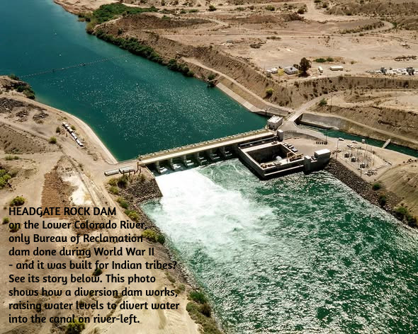
The other was a modest diversion dam below Parker Dam on the Lower Colorado: Headgate Rock Dam – for the Colorado River Indian Tribes! With all the tribes in the Colorado Basin feeling – righteously – left out of river development, one might think the Bureau would make a bit of a big deal about the fact that their first Colorado River project completed after the Boulder Canyon Project was a diversion dam for irrigating Indian agriculture. Yet I can find none of the usual historical and statistic evidence in the Bureau websites about the Headgate Rock Dam, like they have for all of the other Colorado River projects, each getting its own website. Possibly this is because the operation of the dam was turned over to the Bureau of Indian Affairs Office after construction was finished.
It is, however, an interesting story. The tribes along the river were farming like Nile Valley Egyptians, planting in the new layer of silt laid down annually by the snowmelt floods, crops that needed little further irrigation. That worked until the federal Indian agents started moving Hopi and Navajo bands onto their reservation in the 1860s – the reservations truly were ‘concentration camps,’ forcing the move to ‘civilized’ agriculture. This had moved the Indian agents to acquire some pumps round the turn of the century, to water land beyond the riparian floodplain. But when the gates on Hoover Dam were closed in the mid-1930s, that ended the annual snowmelt floods, also ending the traditional agricultural economy.
So the Bureau plotted out a gravity-flow diversion dam and canal in 1938, and began construction. But construction did not really accelerate until 1941, when in one of America’s most shamefully hysteric events 17,000 Japanese-Americans were ‘relocated’ to the Colorado River Indian Tribes (CRIT) reservation – undeniably a concentration camp at that point, if only for the concentration of people. But that added not just a lot of hungry mouths, but a proven workforce that joined the First People in working on the Headgate Rock Diversion Dam and the canal works to carry the water.
It would be both insensitive and naive to speak of a ‘happy ending,’ but as the interred Japanese did in many of the desert places they were sent to, their concentration camp became a very livable village system; some stayed on after the war, and today there is a memorial monument and periodic celebration commemorating the positive relationship that developed between two ‘unwanted peoples’ – the uprooted Japanese and the Indians who forcibly shared their homeland. A story that, for some reason, the Bureau is not interested in telling….
Meanwhile, however, the Bureau was not lying dormant. Immediately after the war’s end, the Bureau released what amounted to a smorgasbord of opportunities, under the title The Colorado River: A Natural Menace Becomes a National Resource. This proposed 134 possible projects for the development of the entire river basin for human uses – cautioning that there was not enough water in the river to build them all, thereby intruding the good old all-American element of interstate competition. Fifty-eight of those proposed projects were for the Lower Basin states, but the other 88 were for the Upper Basin states. If the pre-war Colorado River development had all been about the Compact’s Lower Basin states, the post-war development would begin with controlling the ‘natural menace’ in the Upper Basin states and putting the water to work.
The 1946 Bureau report divided the Upper Basin into three different divisions, based on the River’s three main tributaries above the canyons: there were 33 projects for the Green River Division out of Wyoming and Colorado but flowing mostly (but not entirely) through eastern Utah; 35 projects for the ‘Grand Division’ (the Upper Colorado-Gunnison Rivers, originating in Colorado but flowing into Utah (using the older name for the Upper Colorado); and 20 projects for the San Juan Division, most of whose tributary waters flowed out of Colorado’s San Juan Mountains but the river itself flowed mostly through northern New Mexico and southern Utah.
The Little Snake River is about to join the Yampa River on Oct. 8, 2020. Photo credit: Allen Best/Big Pivots
An obvious challenge lay in the absence of any coordination between those natural divisions of the Upper Basin and the geographically-irrelevant state boundaries. Every major tributary except for the Gunnison River crossed at least one state boundary. The Little Snake River in the Yampa River Basin is the extreme example, crossing the Colorado-Wyoming border seven times.
Grand River Ditch in Rocky Mountain National Park. Photo credit: Greg Hobbs
Nonetheless, the first task for the Upper Basin, before the Bureau could go to work, was to divide the use of the waters among the states in an Upper Colorado River Basin Compact. This task was made the more difficult because the state boundaries bundled the relatively water-rich Upper Colorado River Basin with other drier river basins – the Platte, Arkansas and Rio Grande rivers in Colorado, Wyoming and New Mexico; and the Great Basin in Utah. And water law – plus fervent belief in big-project technology – accommodated the notion of moving water from one river basin to another. The Grand Ditch from high on Colorado’s West Slope to the Poudre River on the East Slope was already being dug by the turn of the century. Unlike water for either agricultural or municipal uses within a basin, nothing flows back into the basin of origin from a transmountain diversion – a total depletion.
The task of dividing the use of the Upper Basin waters was also complicated by vague writing in the Colorado River Compact – Article III(d), stating that ‘the States of the Upper Division will note (sic) cause the flow of the river at Lee Ferry to be depleted below an aggregate of 75,000,000 acre feet for any period of ten consecutive years.’ Was this a caution to the Upper Basin states to make sure their uses did not start cutting into the Lower Basin’s shares? Or was it a mandate to those states to deliver that much water even if it meant cutting their own uses – essentially turning the Compact into a ‘senior water right’ to the Lower Basin?
This was not really foreseen as an issue in 1922, with a river that early 20th-century optimism assumed would run at around 18 million acre-feet (maf) forever. But after the drought of the 1930s and the middling flows of early 40s, plus the mid-war treaty with Mexico to deliver 1.5 maf across that border every year, it was evident to the Upper Basin state negotiators, who gathered in 1946 to work on an Upper Basin Compact, that the river might not always produce the 7.5 maf the Compact promised to them. Their preferred interpretation of the Compact’s Article III(d) would obviously be the ‘cautionary’ interpretation – don’t be the cause of the river flow declining. But they also knew that California and Arizona would interpret it as a ‘mandate’ – and since Congress would have to ratify their Compact, they chose to not ‘waken the bear,’ as California’s current governor would put it.
So rather than dividing the use of the Upper River’s hoped-for allotment of 7.5 maf in four set figures, like the Lower Basin has, they chose to divide it into percentages: 51.75% for Colorado (which provides around 70% of the river’s water), 23% for Utah, 13% for Wyoming, and 11.25% for New Mexico. They also chose to calculate their usage by their depletions of a stream’s flow rather than adding up consumptive uses, as the Lower Basin does. I will not pretend to know exactly how this works – except to note that a measure of depletions by users also includes evaporation and transpiration, while the Lower Basin’s measures allows such considerations to get lost in their calculations of usage. (The Bureau calculates Lower Basin evaporation and transpiration on a separate spreadsheet from recorded uses.)
Meanwhile, however -… Don’t you just love it when a writer intrudes ‘Meanwhile, however’ into an already complicated mess? This is my secondmeanwhile in this post, so it is probably time to give you a break, with only a teaser about the next step in this growing ganglia of complexity.
While the still somewhat beloved Bureau of Reclamation, creator of Hoover Dam and the New West, was just cranking up the mill for the development of the rest of the Colorado River Basin waters, the Upper Basin states had already been working out their separate peace over the transmountain diversion issue between the wet Colorado River basins of origin with low populations, and drier basins of destination with large populations across the mountains. This is a story that goes back to the 1930s, with the ‘New Deal’ federal government putting out large amounts of funding for public projects in all the states – but with the caveat that for any state to tap into that funding, the whole state had to want the project…. Stay tuned for the next thrilling episode in The West’s Romance with Conquest.
Colorado transmountain diversions via the State Engineer’s office
Oh dear. You’d best get your skiing in now, because it looks like the spring melt will hit a lot earlier than usual. A big heat wave is on its way to the West, with the most unseasonably warm temperatures occurring in the Southwest and Four Corners regions, further dimming hopes for a spring snowpack-bolstering miracle. This could mean that mountain snowpack in the Colorado River Basin has already peaked, which would be dire for streamflows.
My apologies for bringing you more doom and gloom climate news. At least it’s cold in Alaska, though.
And that’s topping off the warmest winter on record in the Upper Colorado River Basin.
☘️ Annals of Alfalfa 🍀
As the Colorado River shrinks, the “simple” and “obvious” solutions to the crisis seem to multiply.
You know, it’s a lot of: “Whatchya gotta do is …. “
“… stop watering them golf courses.”
“… stop population growth.”
“… keep people from moving to deserts.”
“… shut down dem data centers!”
And then, the most common one: “ … stop raising cattle and hay in the desert.”
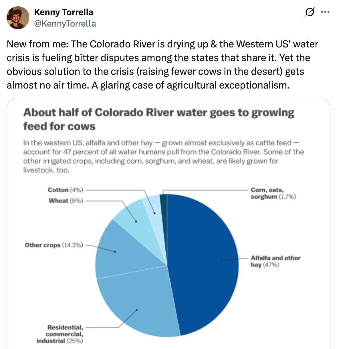
Kenny Torrella, who writes for Vox, brought up that last one on the social media platform Blue Sky recently:
While this fix holds more water (so to speak) than the preceding ones, it is not actually a solution — at least not a workable one.
There is only one obvious remedy for the Colorado River crisis, and that is for its collective users to consume less of the river’s water. Since irrigating alfalfa takes up a larger share of the river’s water than any other single use, it seems to follow that growing less of the crop would leave more water in the river. But this does not account for the way water law works.
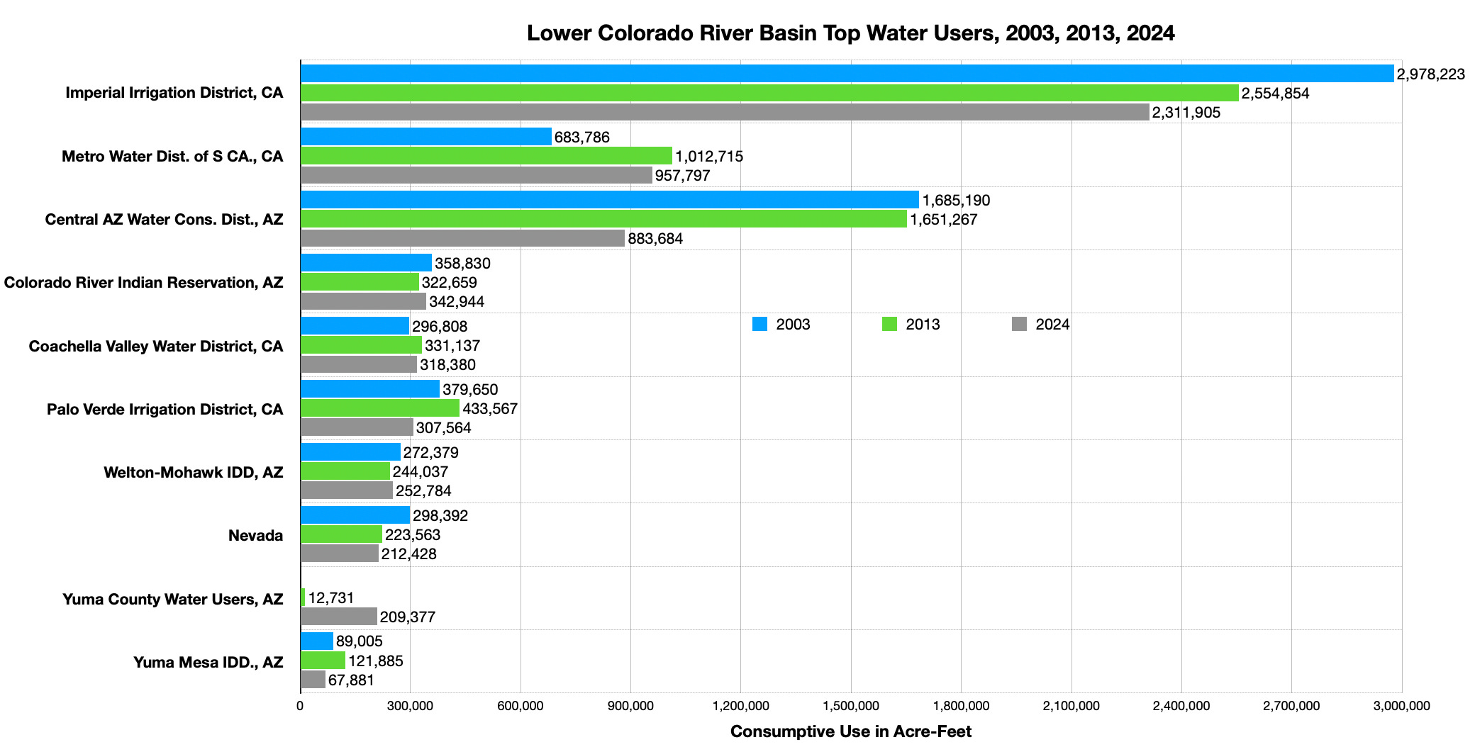
Let’s imagine that California could designate alfalfa as an illicit crop and ban cultivation of it and other livestock forage crops. That would force a bunch of big farmers in the Imperial Valley — home of the largest single water user on the entire river — to tear up about 200,000 acres of water-guzzling alfalfa.
Problem solved? Not quite.
The Salton Sea (pictured above ) straddles the Imperial and Coachella valleys. (Source: Water Education Foundation)
The Imperial Irrigation District has senior rights to use a buttload of Colorado River water for “beneficial use,” which in this case means agriculture. Specific farmers may decide that without alfalfa, they’ll simply throw in the towel and stop irrigating altogether. But there’s no way the irrigation district as a whole is going to stop diverting that water without some sort of compensation, because while farmers pay the irrigation district a negligible amount for water, the irrigation district gets it virtually for free. That means the district is incentivized to continue using all of the water to which it has rights, and rather than leaving it in the river, they would most likely sell it to another farmer growing another crop. The result: No net reduction in water consumption.
Torrella’s claim that alfalfa’s water use gets “almost no air time” is a little off. I’ve written about it at least a zillion times at the Land Desk and at High Country News, but many a mainstream news outlet has done the same. Even the Paris Review had a pieceon it. The reason “growing less alfalfa” doesn’t show up in talks about negotiations over the Colorado River, or as an alternative in the feds’ proposed operating plan, is not because of “agricultural exceptionalism,” but because these aren’t crop-level negotiations.
The two Colorado River basins and the feds are currently looking at the macro level, and trying to hash out which basin will take what level of cuts, how those cuts will be determined, and what if anything will be done to fend off dead pool at Glen Canyon Dam. Only when all of that is settled can the individual states in each basin duke it out over respective consumption cuts, followed by the biggest users within each state. Finally, those users can make decisions about how to use their now smaller share of water, and really just about anything goes so long as it fits the definition of “beneficial use.”
Maybe they’ll continue to grow alfalfa using less water via deficit irrigation, maybe they’ll opt for a higher-value, less water-intensive crop like broccoli, maybe they’ll use it to grow cacti, but what counts is that they’ll be taking less water out of the Colorado River, regardless.
It’s not that the alfalfaphobes are wrong; it probably is a good idea to grow less alfalfa and fewer cows in the desert. For that matter, we should fallow golf courses, restrict urban growth, and take other steps to live within our means. But what’s needed now is an agreement on drastic and immediate cuts in water consumption. What that means for alfalfa or golf courses or Arizona suburbs will be dealt with later.
Now for a little data dump re alfalfa and other irrigated crops in Imperial County, California1:
$238,752,000: Gross value of alfalfa hay harvested in Imperial County, California, in 2024.
183,252: Harvested acres of alfalfa hay in 2024.
$1,300/acre: Per-acre value of alfalfa hay harvested in 2024.
6 acre-feet: Approximate amount of water required to irrigate one acre of alfalfa in the Imperial Valley for a year.
$20/acre-foot: Amount Imperial Valley farmers pay for water.
$134,822,000: Gross value of broccoli harvested in Imperial County in 2024.
$12,136/acre: Per-acre value of broccoli harvested in 2024.
3 acre-feet: Approximate amount of water required to irrigate one acre of broccoli in the Imperial Valley.
$259,861,000: Gross value of head and leaf lettuce harvested in 2024.
$9,012/acre: Per-acre value of head and leaf lettuce harvested in 2024.
2-3 acre-feet: Approximate amount of water required to irrigate one acre of lettuce in the Imperial Valley.
🐟 Colorado River Chronicles 💧
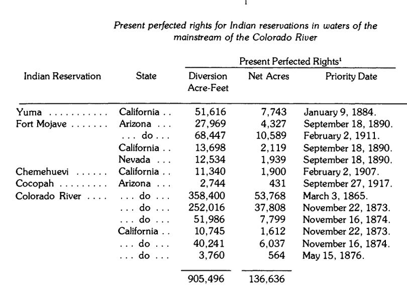
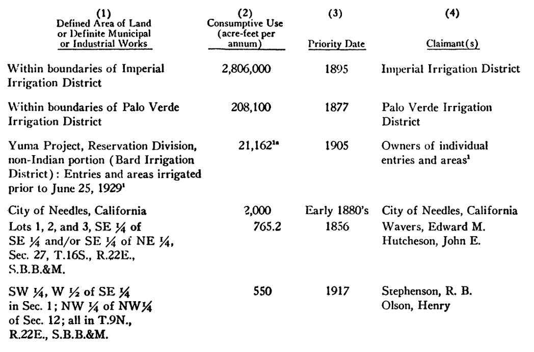
Today’s vocabulary term is: Present Perfected Rights, a term you may be hearing a lot more of in coming months.
Article VIII of the Colorado River Compact states:
Later, the Boulder Canyon Project Act of 1928 decreed that the “dam and reservoir” of the title (which would become Hoover Dam and Lake Mead) shall be used for the “satisfaction of present perfected rights … .”
That’s fine and good, but what are present perfected rights, or PPRs? The Compact never says what that term means. In fact, it wasn’t clearly defined until the Supreme Court laid it out in its 1964 Arizona v. California decision, a key document in the Law of the River:
Clear as mud, right?
Generally speaking, PPRs are the most senior rights on the Colorado River, they predate the Colorado River Compact, and are the last rights subject to curtailment in times of shortage. They are the “first” in the “first in time, first in right” summation of the prior appropriation doctrine, which is the foundation of Western water law.
Arizona v. California goes on to say that “in any year where there is fewer than 7.5 million acre-feet available for use in California, Nevada, and Arizona, the Secretary of the Interior must first supply water to the PPRs in order of priority, regardless of state lines.” Similarly, the Upper Basin’s PPRs will be the last to be cut if curtailments are necessary to meet its non-depletion/minimum-delivery obligation to the Lower Basin.
The Supreme Court required the Lower Basin to submit a list of its PPRs, and here they are from the document itself as submitted in 1967. Some of these, especially the tribal rights, were updated and added to later on.
The first set is for tribal nations in the Lower Basin only:
These are the top six non-tribal PPRs in the Lower Basin by order of size of diversion. There are many more smaller PPRs that are not listed here:
🗺️ Messing with Maps 🧭
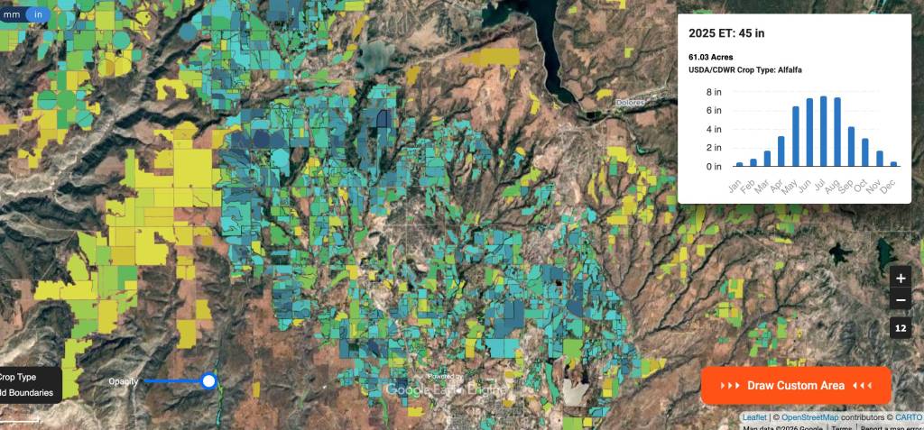
I’m not sure if I’ve featured this one before, but if so, it’s worth re-upping due to its heightened relevance this year. It’s the Open ET mapping tool, with ET standing for evapotranspiration. It uses satellite imagery to calculate evapotranspiration from individual fields, which is an indicator of how much irrigation is being used and what crop is being grown. Hovering over a field will bring up a chart showing ET for each month, the acreage, and the crop type.
The Colorado River flows beneath Navajo Bridge in Arizona on Dec. 27, 2019. Three tribes in Arizona are pushing for a settlement that would solidify their access to the River’s water and provide billions of dollars for water infrastructure. Photo credit: Mitch Tobin/The Water Desk
Click the link to read the article on the KJZZ website (Alex Hager). Here’s an excerpt:
March 11, 2026
Coverage of tribal natural resources is supported in part by Catena Foundation
Tribal leaders and U.S. senators spoke out in support of a measure that would solidify access to water for three tribes with land in Arizona during a Wednesday [March 11, 2026] hearing at the Senate Indian Affairs Committee. The Northeastern Arizona Indian Water Rights Settlement, or NAIWRSA, would settle claims to water by the Navajo, Hopi and San Juan Southern Paiute tribes, and provide $5 billion to build new water delivery systems and help the tribes access their water. The settlement would need to be authorized by congress to go into effect. At Wednesday’s Senate committee hearing, impassioned pleas to bring water to tribal communities ran up against federal concerns about the cost of a settlement, and talks of hesitation from some states that use the Colorado River.
“This settlement is more than a legal agreement,” said Lamar Keevama, chairman of the Hopi Tribe. “It is a path forward. It allows the Hopi tribe to remain and protect our homeland, supports economic development and ensures that our communities have the basic resources necessary to thrive.”
An official with the Interior Department said he was supportive of the settlement’s aims, but was concerned with the cost.
“$5 billion is a lot of money,” said Scott Cameron, Interior’s principal deputy assistant secretary for water and science. “We look forward to working with the committee and with the three tribes and the other interested parties, of which there are quite a few, to see if we can’t creatively come up with some ideas to still satisfy the purposes of the bill at somewhat less cost.”
Lamar Keevama, chairman of the Hopi Tribe, testifies in front of a U.S. Senate Committee on March 11, 2026. “This settlement is more than a legal agreement,” he said. “It is a path forward.” Photo credit: U.S. Senate Committee On Indian Affairs
NAIWRSA has partially been hung up by a unique geographical challenge and longstanding tensions between states that share the Colorado River. The river, which is at the heart of settlement talks, is divided into two regions — the Upper Basin and the Lower Basin. Its water is managed by the seven states that use it, and they have been deeply split about new policies to share water. They generally fall into two camps — the Upper Basin states of Colorado, Utah, Wyoming and New Mexico, and the Lower Basin states of Arizona, California and Nevada. The Navajo Nation straddles both basins, with land in Arizona, New Mexico and Utah. Some of its land falls within a portion of Arizona that is technically part of the Upper Basin. Some Upper Basin states worry that the settlement would allow the Navajo Nation to take water from the Upper Basin and lease it for use in the Lower Basin, creating a precedent that could open the door to more transfers out of the Upper Basin. Buu Nygren, president of the Navajo Nation, pushed back on that suggestion.
“It is hard to imagine that any Upper Basin state would object to my people being able to use water that they have used for decades simply because of the fear of a potential precedent,” he said.
From the 2018 Tribal Water Study, this graphic shows the location of the 29 federally-recognized tribes in the Colorado River Basin. Map credit: USBR
Sen. Mike Lee and Rep. Celeste Maloy, both MAGA Republicans from Utah, have formally introduced legislation to use the Congressional Review Act to revoke the Biden-era management plan for Grand Staircase-Escalante National Monument. If successful, the move would also bar the feds from developing a new management plan that resembles the current one.
The current management plan is not draconian by any means. It was fashioned over years, with oodles of input and compromise, and is far less restrictive than the preservation-oriented alternatives It allowed for motorized vehicle use on designated routes and added almost no new restrictions for livestock grazing. Revoking it is not the same as rescinding the national monument or shrinking its boundaries, and will not open up any of the monument to new mining claims or oil and gas leases.
So it’s not clear what Lee and Maloy hope to achieve, except to strike a blow to a national monument that they don’t like and to throw oversight of 1.9 million acres of public land into disarray. Or maybe they’re just trying to build up their anti-public-land credentials to head off challenges from even more extreme candidates such as, say, Phil Lyman, who just challenged Maloy for her 3rd District congressional seat.
You still have time to let your representatives in Congress know how you feel.
Ugggg.
While well-intentioned greens are parsing BLM director nominee Steve Pearce’s words for indications he might be inclined to sell off public land, the Trump administration is orchestrating a massive de facto transfer of public lands to oil and gas companies.
I’m talking about oil and gas leasing. And no, it’s not an actual transfer of public land; the lessee does not take title to the land, nor can they block public access, but they do get the rights to drill that land and preclude other uses on it. And, once it is drilled, the land is scraped of all vegetation, covered with heavy equipment, poked with a massive drill, hydraulically fractured, and becomes an industrial-scale, methane-, hydrogen sulfide-, and VOC-oozing hydrocarbon factory for many decades to come.
On the auction block this June is a good chunk of slickrock-studded landscape northwest of Moab, between Hwy. 191 and the Green River, along with some parcels in the Lisbon Valley. All in all, the BLM proposes selling off 39 parcels covering some 71,600 acres. You have until March 30 to give your two cents. https://eplanning.blm.gov/Project-Home/?id=6fad61fa-a7f2-f011-8407-001dd80bcf93
***
Of course, sometimes the BLM holds an oil and gas auction and no one comes. That was the case with the Big Beautiful Cook Inlet Oil and Gas Lease Sale (yes, that is the official name) held March 4 in Alaska, in which more than 1 million acres of offshore leases were put on the block. There were zero bids. Zilch. Nada. Someday, maybe every oil and gas lease sale will be like that.
***
A federal judge has halted construction of the Northern Corridor Highway through the Red Cliffs National Conservation Area near St. George, Utah, while an advocates’ lawsuit proceeds.
The BLM approved the contested project earlier this year. The Utah Department of Transportation, apparently wanting to get started before a legal challenge could take hold, began erecting fencing along the project, even though their development plan hadn’t been approved. This activity would have disturbed desert tortoise habitat.
The court did not approve, blocking further work until the lawsuit is resolved.
***
In other Utah road news, Garfield County began chip-sealing the first ten miles of the Hole-in-the-Rock Road in Grand Staircase-Escalante National Monument, drawing protest and a lawsuit from environmental groups.
The county has been aching to pave the gravel road, which often becomes riddled with potholes and washboards, for years, but failed to gain BLM approval. Environmental groups have resisted, saying that improving the road could lead to more paving or widening of primitive byways in the area, and would increase the number of people and their impacts on the fragile landscape.
The county has also wielded RS-2477 — an 1866 statute — in an attempt to wrest control over the byway, which leads to the famed Colorado River crossing of the 1879 Latter Day Saint expedition to Bluff. Last July, a federal court granted Garfield County quiet title to the section of the road within the county.
Garfield County interpreted that as a green light to chip seal the road.
That triggered a lawsuit from the Southern Utah Wilderness Alliance, pointing out that because the road crosses BLM land, the county must still get the agency’s go-ahead for major improvements. It didn’t, but the BLM has done nothing to stop the action, which SUWA says violates federal environmental laws.
🥵 Aridification Watch 🐫
I was accused recently of being all “doom and gloom” when it comes to this year’s snow levels, so I set out to find some good news to report. It didn’t go so well, but I did uncover a few tiny nuggets, including:
After the February storms, the Center for Snow and Avalanche Studies reported: “This is rare, but currently we do not have any dust on the snowpack.” That’s good news because dust on the snow decreases albedo (reflectivity), leading to faster snowmelt. We need what little we have to stick around as long as possible. Buzzkill: The really big dust events tend to come in the springtime.
I tend to rely on a handful of high-elevation SNOTEL sites as indicators of how the mountain snowpack is doing. One of them is in Columbus Basin in the La Plata Mountains. Like everywhere else, the snow water equivalent there is way below normal. However, it’s still above 2002 levels for early March, so that’s kind of heartening. I guess?
Hope lies in 1990: That year, snowpack levels in the Animas River watershed were lower on March 6 than they are today. But beginning in mid-March, storms pummeled the region, resulting in a May 3, 1990, snowpack peak that was 94% of normal and bringing runoff up to decent levels. We could see a repeat of that March-April-May miracle!
And … oh. I’ve just been informed that there is no more good news.
As grim as this may be, it also offers a glimmer of hope: The snowpack could still recover like it did in 1990. Source: NRCS.
Now back to our regularly scheduled doom and gloom, bullet style.
The late February-early March heat wave across most of the West shattered thousands of daily high temperature records and dozens of monthly ones, topping off the West’s warmest winter on record. Monthly records (121 tied or broken nationwide during the last week of Feb.) include:
Dinosaur National Monument in Utah hit 68° F on 2/26;
Imperial County, California’s airport reached 97° on 2/28;
Albuquerque airport, 77° on 2/25;
Hovenweep National Monument in Utah, 70° on 2/28;
Havasu, Arizona, and Malibu Hills, California, were both 93° on 2/27;
Sampling of daily records (845 broken or tied during the last week of Feb) include:
Mancos, Colorado, hit 50° F on 2/28; the aforementioned Columbus Basin (elev. 10,784 feet) reached 48° and Mineral Creek, Colorado, hit 51° that same day;
McClure Pass, Colorado, reached 49° on 2/28;
Needles, California, and Phoenix both hit 92° on 2/28;
South Lake Tahoe airport, 60° on 2/28.
Those kinds of temperatures melt the snow, even on north faces, causing this year’s snow water equivalent graph lines to uncharacteristically dip during a time of year when they normally would be shooting upward. They also heighten risk of wildfires in the low country. On the last day of February, a blaze broke out in Chautauqua Park in Boulder, forcing some evacuations before it was contained. Another one was sparked west of Boulder on March 4.
The North Fork of the Gunnison, which feeds the ditches in and around Paonia and Hotchkiss and the orchards, vineyards, and farms there, is in trouble. This year’s snowpack so far is in the same boat as it was on this date in 2002 and 2018, two very dry years when irrigation ditches were shut off early in the growing season.
Aside from the entire Upper Colorado River watershed, I’m also especially concerned about the North Fork of the Gunnison. Snowpack levels are at a record low for this date, or about the same as they were in 2018, and Paonia Reservoir is currently utilizing just 22% of its storage capacity (note the record high temp on McClure Pass above, at the headwaters of Muddy Creek, which feeds the reservoir). This does not bode well for the many small farmers who rely on the river for irrigation. In 2018, downstream senior rights holders made a call on the river in June, forcing junior irrigators in the North Fork to lose water perilously early in the season.
This bad situation could be exacerbated if the feds were to decide to release water from Paonia Reservoir in an attempt to buoy Lake Powell water levels. While this is hypothetical, it is not beyond the realm of possibility by any means.
And, saving for some sort of April-May miracle, the Colorado River runoff will be extraordinarily scant this spring and summer, almost certainly pushing Lake Powell to critically low levels.
***
That demands a plan, and the Bureau of Reclamation came up with several alternatives last month. Most of the major players have commented on the alternatives, and it’s safe to say that almost no one is satisfied with any of them — albeit for different reasons.
One of the more universal critiques is that none of the alternatives adequately address dry and critically dry scenarios on the river, like the one that is likely to occur this summer. The draft environmental impact statement itself states, “In critically dry periods, all alternatives have unacceptable performance.” That leaves many wondering what, exactly, the Bureau of Reclamation plans to do to keep the system from collapsing over the next nine months.
There is a lot here, and it gets pretty darned deep in the wonk weeds. Still, what I’ve included is a mere sampling of some of the comments from just a few of the commenters in the hope that it will give readers a better idea of where different stakeholders stand, and how complicated and difficult this situation really is.
For those who don’t like weeds, here’s the short version: It’s a tangled mess with a bunch of moving pieces and stakeholders who are digging in their heels to ensure that their constituents get the water they need to drink, irrigate crops, run industries, or whatever. And they’re all butting up against the reality that there simply isn’t enough water in the river to go around.
Arizona is understandably displeased because they would take the greatest hit under any alternative. This is not because they are somehow inferior, but because the water rights to the Central Arizona Project, which delivers Colorado River water to Phoenix and Tucson, are junior to most other big users in the Lower Basin. “… each alternative, though broad in scope, will translate in practice specifically as drastic reductions to Arizona’s water supply.”
“We are deeply troubled that Reclamation all but abandons its increasingly critical role in ensuring the Upper Basin States fulfill their delivery obligations under the Colorado River Compact of 1922 (Compact).” This refers to the non-depletion or minimum-delivery obligation that I’ve written about before.
“The DEIS itself acknowledges that ‘widespread impacts on social and economic conditions may also be possible,’ including circumstances in which municipalities may need to pursue alternative or even hauled water sources to maintain basic services. Drastic cuts could have cascading consequences for human health and safety and destabilize the lives and livelihoods of Arizonans, tribal communities, and critical industries that rely on Colorado River supplies.”
They say the cuts will damage the state’s agriculture, manufacturing, and aerospace industries and that it will put at risk: “… the largest concentration of advanced semiconductor manufacturing investment in the country, representing roughly $200 billion in announced projects since 2020.” Semiconductor production is extremely water-intensive, with the average factory consuming up to 10 million gallons of ultra-pure water daily.
They call on any plans to “include verifiable Upper Basin conservation measures commensurate with Lower Basin conservation measures, including identifying tangible metrics that demonstrate Upper Basin water conservation.”
“We believe that Reclamation must institute bold and meaningful changes but that those changes must be implemented in a manner that is consistent with the 1922 Colorado River Compact, the 1944 binational treaty with Mexico, the 1948 Upper Basin Compact, and the other foundational elements of the Law of the River.”
“Reclamation must prioritize hydrologic reality over predictability for Lower Basin users. The Draft EIS places undue emphasis on predictability1 for water users, a goal that is unattainable under future climate conditions unless system storage is replenished and overall demands are permanently reduced to match the supply.”
“… several alternatives include Upper Basin water conservation ranging from zero to 500,000 acre-feet annually … <but> … fails to analyze the environmental or socioeconomic impacts associated with these conservation volumes.” It adds that a 200,000 acre-feet reduction in the Upper Basin would require fallowing 52,000 acres on the Western Slope.
“Lower Basin water use must be reduced by 1.5 million acre-feet at all times, regardless of the alternative. This amount represents system losses (i.e., transit losses and reservoir evaporation) and should not be classified as shortage.” This is a longstanding issue. Reservoir evaporation and other such losses are counted against the Upper Basin’s consumptive use, in part because of the non-depletion obligation. The same is not true for the Lower Basin; when they say they use 7.5 million acre-feet, that does not include evaporation or seepage or other system losses, only what they pull out of the river.
“The range of alternatives must include option(s) that perform under critically dry hydrology. Currently, none of the alternatives in the Draft EIS perform under critically dry hydrology. At least one alternative must protect critical infrastructure and respond effectively to significantly lower river flows than historically observed.” We are approaching a critically dry situation this summer, when the feds will have to decide whether and how to keep Lake Powell from dropping below minimum power pool. So far there is no plan for this.
“Hydrology must drive Post-2026 operations. Operating guidelines based upon comparative reservoir elevations which do not factor in real time hydrology have been disastrous for protecting storage in Lake Powell and thus, have failed to provide the water supply certainty for the Upper Basin intended by the Law of the River …”
“Interbasin transactions must not be allowed in the proposed action.” That is, Upper Basin users with senior rights should not be able to sell their water to Lower Basin users.
The team of Anne Castle, John Fleck, Eric Kuhn, Jack Schmidt, Katherine Tara, and Kathryn Soren, river experts and academics who aren’t representing any specific water user, state, or basin, also weighed in. Their comments, as Fleck put it in his Inkstain blog, could be summed up as: “Tell us what you’re going to do.” And, also:
The group calls on Interior to “primarily focus on the Dry and Critically Dry scenarios. … We think it important to be mindful of the underlying year-to-year hydrology of the 21st century as we look to the future. … we are struck by the fact that 50% of the individual years of the 21st century have been Dry or Critically Dry, and only 27% of the years (including 2017, 2019, 2023) have been Moderately Wet or Wet.”
“We suggest that the DEIS include a description of an alternative that performs sufficiently well during Dry scenarios and an alternative that performs sufficiently well during Critically Dry scenarios.”
“ … it is imperative that Reclamation provide a clear picture of what actions will be implemented in the near term (i.e., next year, next 3 years, next 5 years) to protect critical infrastructure, and to protect public health and safety.”
Noting that lawsuits are inevitable regardless of which alternative the feds choose, they urge them to avoid “safe” options and go with a plan with “… the broadest possible interpretation of Reclamation’s and Interior’s authority to provide a predictable and resilient Colorado River so that the system can continue to operate in a reasonable manner while the lawsuits proceed.”
Call on the feds to “… explore these areas for possible inclusion in the preferred alternative:
Reduction of deliveries in the Lower Basin in excess of 1.48 MAF when insufficient water is available for release.
Provision for releases of water from the Colorado River Storage Project initial units as necessary to protect critical elevations in Lake Powell and ensure continued Upper Basin Compact compliance.
Operation of federal projects in the Upper Basin to store or use less water during critical periods.
Continuation, expansion, and modification of Assigned Water programs (such as Intentionally Created Surplus and Mexican Water Reserve) with improvements to ensure operational neutrality and minimize adverse impact to priority water.
Establishing a conservation pool in Lake Powell for storing Upper Basin conserved water to be utilized for Compact compliance purposes. For more on conservation pools, check out the Shannon Mulane’s explainer in the Colorado Sun.
The group finds fault with the plan for not addressing “the need for enforceable reductions in the Upper Basin.” They go with the Lower Basin’s interpretation of the non-depletion/minimum-delivery obligation, saying that the Colorado River Compact does not guarantee that the Upper Basin gets half of the water in the river. Plus, they point out that the plan’s demand forecasts for the Upper Basin are unrealistically high, putting more of the burden for cuts on the Lower Basin.
The Southern Nevada Water Authority and Colorado River Commission of Nevadaare especially critical, writing:
“Since the onset of drought in 2002, <Nevada water users> have reduced their overall Colorado River water consumption by more than 40 percent even as our population grew by more than 875,000 people. And they, unlike so many others, have not ignored the reality facing the basin by making the flimsy argument that our economy cannot prosper while water consumption decreases.”
Like Arizona, they bring up the minimum-delivery/non-depletion clause of the Colorado River Compact and call on the Upper Basin to comply with it.
Interior’s “… approach to protecting the Glen Canyon Dam river outlet works by reducing releases from Lake Powell—rather than making infrastructure repairs and improvements—is shortsighted and harms Nevada and the Lower Basin States.”
The Upper Colorado River Commissionemphasizes the Lower Basin’s history of exceeding its Colorado River Compact allocation and failing to account for evaporation and other system losses. Colorado’s Upper Colorado River CommissionerBecky Mitchell submitted similar, very detailed comments that emphasized the Colorado River Compact’s equitable division of the river between the Upper Basin and Lower Basin. She points out that the Lower Basin’s interpretation of the minimum-delivery/non-depletion clause contradicts and even negates that division.
📖 Reading (and watching) Room 🧐
Must read: Teal Lehto’s and Len Necefer’s speculative fiction take on what might happen on the Colorado River, and to the people who rely on it, in 2030 if current climatic trends continue. It’s dramatic and sensational and catastrophic, but it’s also very well informed, smart, and not at all far-fetched, in my humble opinion.
A screenshot from a new Central Arizona Project video, which says if water deliveries to the canal system are cut too much it will “cripple our state, flatten our economy and weaken our national defense.” Provided by Central Arizona Project
Click the link to read the article the Tucson.com website (Tony Davis). Here’s an excerpt:
March 9, 2026
Arizona will take nearly a $3 trillion total economic hit and lose millions of jobs that would have come to the state by 2060 if Central Arizona Project deliveries are halted by the federal government, a new report from the project’s governing agency says. A CAP consultant’s report said the state’s total economic output would by 2060 be 11% to 14% lower than it otherwise would have been, under two proposed federal alternatives for managing the Colorado River. At worst, the state’s total jobs would shrink by 7.9% if the project’s supplies were eliminated, the report said. In addition, the state would see substantial declines in population and housing growth by then with massive CAP cuts, compared to what would have happened without them, said the report.
The three-county agency that runs the CAP’s canal system, stretching from Lake Havasu on the Colorado River to just south of Tucson, commissioned this report from the consulting firm WestWater Research, based in Boise, Idaho. The agency, known as the Central Arizona Water Conservation District, has managed daily operations for CAP since it was under construction in the 1970s. CAP submitted this report as part of its comments sharply criticizing the U.S. Bureau of Reclamation’s draft environmental impact statement on proposed alternatives aimed at curbing excessive water use by cities and farms in the seven-state Colorado River Basin. It comes out shortly after project officials released a video warning that such cuts would “flatten” Arizona’s economy. At the time the video came out, some outside water experts said it oversimplified and overestimated the impacts of CAP cuts, in part because the state and local governments have already stored huge amounts of CAP water underground to prepare for such emergencies. But the new report says those supplies will eventually be exhausted, forcing many cities to return to groundwater pumping, and that some shortages of groundwater supplies themselves also could begin in some regions as soon as the early 2030s.
Map of the Colorado River drainage basin, created using USGS data. By Shannon1 Creative Commons Attribution-Share Alike 4.0
The Bureau of Land Management’s Mineral & Land Records System seems like a strange place to get trolled. But I think it just happened. I was looking through the MLRS to try to get an idea of whether insanely high gold and silver prices, and relatively strong uranium prices, had inspired companies or speculators to stake new mining claims n southwestern Colorado and southeastern Utah, when I came across something that seemed almost satirical.
Late last year, Kimmerle Mining Company staked four 20.66-acre lode claims in Garfield County, Utah, on the east slope of the Henry Mountains (just east of Mt. Pennell). The claim’s names? Trump I, Trump 2, Trump 3, and Trump 4.
The Kimmerle family, of Moab, control hundreds of mining claims across southeastern Utah. But they generally don’t mine them, except, it seems, to make a point.
The Kimmerles are the ones who staked mining claims on a mesa just east of Hideout Canyon inside Bears Ears National Monument just months just before the Obama administration withdrew the area from new mining claims. After Trump shrunk the monument to exclude the White Canyon area in 2017, and just before Biden restored the boundaries in 2021, Kimmerle Mining staked five new claims in the area and acquired additional claims from another mining company. Kimmerle Mining promptly filed for a permit to do exploration work there, but the BLM said they had to demonstrate the claims “validity,” or show that they contained “valuable minerals.” The process for doing so would cost up to $100,000.
Shortly thereafter, Kimmerle joined the state of Utah’s lawsuit seeking to eviscerate the national monument, claiming that its establishment had caused him to lose out on mining profits.
No word on whether the firm plans on drilling or mining its Trump claims, but at least we know these folks’ political leaning.
There have been a handful of other notable mining claim locations in the area in the past six months, including:
Platoro West Inc., located in Durango, staked twelve 20.66-acre lode claims southeast of Ouray, Colorado, in the Bear Creek drainage near Darley and Engineer Mountains. The company is registered under the name of William Sheriff, who was recently named executive chairman of Verdera Energy, which has interests in in-situ uranium mining in New Mexico.
CCKC Inc., of Philadelphia, located three 20-acre placer claims in Dolores County along the Dolores River upstream of Rico.
Roughead Resources of Moab (but which has also been associated with a Houston address) staked fifteen 20.66-acre lode claims in the Lisbon Valley of southeastern Utah near the Mi Vida Mine and the Lisbon Valley Copper Mine. At the same time, the company also staked dozens of claims in Beaver County, Utah.
Fermi Metals of Cocolalla, Idaho, staked twenty-three 20.66-acre claims on the southern slope of the La Sal Mountains, just north of the settlement of La Sal. This is near Energy Fuels’ La Sal Complex uranium mines.
Geobrines International, of Littleton, Colorado, staked twenty-five 20-acre placer claims in Grand County, Utah, along I-70 between Green River and Cisco. This adds to a cluster of previously filed claims in the same area. They are probably looking to do lithium extraction.
Utah Brine Corporation, of Omaha, Nebraska, staked seventy 20-acre claims southwest of the community of La Sal in the Lisbon Valley. UBC appears to be a subsidiary of Omaha Value Inc., which has partnered with an Australian critical materials firm Neometals on its Utah Brine Project, which aims to extract lithium and potash.
Antimony Canyon Sovereign Reserve Inc, a division of Australia firm American Tungsten & Antimony, staked nineteen 20.66-acre lode claims near Antimony, Utah, in Garfield County. The plan is to develop an antimony mine here.
In other mining news:
Metallic Minerals has been eyeing and drilling into a copper deposit in the La Plata Mountains of southwestern Colorado. While actual mining may be a long ways off, concerned locals are already coming together to keep an eye on the project and push back, if necessary. The La Plata Mountains and Public Lands Coalition now has about 225 members from the region, according to Dan King, the coalition’s administrator. Metallic Minerals’ proposal was just one of the catalysts for the coalition, and its mission is much broader and more regional in scope.
Gold and silver prices have shot up tremendously over the last year, probably due to the Trump-effect on the economy and the U.S. dollar, which is stuck at a ridiculously low exchange rate. Gold is now around $5,000/oz, while silver is hovering around $100/oz., compared to just $30 when Trump took office. Uranium’s doing well, too, sitting consistently in the $80/lb to $90/lb range.
Which is to say, mining companies suddenly have a lot more incentive to invest in reopening existing, idle mines or even building new ones (assuming they have faith that the high prices will endure). So far, however, it doesn’t seem to have sparked a surge in new mining activity. Even the Revenue-Virginius silver mine near Ouray, which is purportedly ready to produce ore, remains idle.
The uranium sector does appear to be emerging from its long slumber, but mostly in the form of exploratory drilling, smaller companies selling claims to bigger ones, and staking mining claims on the increasingly sparse sections of public land that aren’t already claimed. Anfield continues work on constructing its Velvet-Wood mine in the Lisbon Valley, but it’s still a ways away from production (and its Shootaring mill is still mothballed and unlicensed).
Energy Fuels is about the only firm actually producing conventional ore. According to their SEC filings, they pulled about 1.5 million pounds of uranium from the Pinyon Plain mine near the Grand Canyon and 155,000 pounds from their La Sal Complex in 2025. Their White Mesa Mill recovered 1 million pounds of uranium, which is a heck of a lot more than in the past, but still is far short of the facility’s 8-million-pound annual capacity. Despite all of this, the company still lost $86 million in 2025.
Meanwhile, the silver and gold mining corporations raked in massive profits, including:
Canadian corporation Barrick, which owns major gold mines in Nevada (Fourmile and Nevada Gold Mines) reported an attributable EBITDA of $8.16 billion last year, the “highest shareholder returns” in the company’s history.
Newmont (which jointly owns Nevada Gold Mines with Barrick) reported an adjusted EBITDA of $13.5 billion.
Kinross, owner of Bald Mountain and Round Mountain in Nevada, Fort Knox and Manh Choh in Alaska, and Kettle River-Curew Project in Washington, reported adjusted net earnings of $2.2 billion
Rio Tinto’s “profit after tax attributable to owners of Rio Tinto (net earnings)” $10 billion.
SSR Mining, which owns a big mine in Nevada, only had a net income of $362 million; but that compares to 2024’s loss of $350 million.
Speaking of commodity prices and profits: American oil and gas companies are poised to make out like bandits thanks to the Trump-Netanyahu war on Iran.
Iran produces some oil and gas. But more importantly, it borders the Strait of Hormuz and has threatened any oil and gas tankers that try to pass through it, effectively closing the passage. That could stanch the flow of oil and gas to the global market, causing prices to rise. The West Texas Intermediate, or WTI, crude oil price has shot up to about $76, the highest it’s been since before Trump took office. This will cause gasoline prices to climb, but also make drilling in the U.S. more profitable, and could spur companies to start using the stockpile of public land drilling permits they’ve amassed over the last year or so.
Liquefied natural gas tankers also are unable to get through the Strait to European markets, which will cause prices of the fuel to skyrocket. It could also force European countries to turn to U.S. LNG exporters, which could echo back to natural gas producing states like New Mexico and Wyoming (and also may increase U.S. natural gas prices if the conflict drags on).
Glen Canyon Dam Must Be Modified to Avoid Draconian Water Supply Disruptions
A guest post by Ron Rudolph
Glen Canyon Dam with the river outlets in use as part of the high-flow experimental release. The outlets are only used occasionally and are not engineered for sustained use. Usually, all of the releases go through the penstocks and the hydroelectric turbines. But that won’t be possible if the lake drops below the level known as minimum power pool. Jonathan P. Thompson photo.
Glen Canyon Dam, which impounds the Colorado River to form Lake Powell, is a single point of failure that poses an unacceptable risk to the functioning of the entire river system. Modifying the dam to allow more water to pass through or around it is an essential component of any plan for allocating the river’s dwindling supply.
The dam’s structural flaw limits the amount of water that can pass from Lake Powell downstream to Lake Mead. Lake Mead, the nation’s largest reservoir, is the primary repository of water for the Colorado River’s so-called Lower Basin states: California, Arizona, and Nevada. A paucity of water released from Lake Powell would eventually force reductions in the amount of water extracted from Lake Mead, diminish drinking water supplies for millions, harm agricultural productivity throughout the southwest, and embroil the federal government, seven states, more than two dozen Tribal Nations, Mexico, and others that share the river’s water in a cascade of costly court cases.
The back of Glen Canyon Dam circa 1964, not long after the reservoir had begun filling up. Here the water level is above dead pool, meaning water can be released via the river outlets, but it is below minimum power pool, so water cannot yet enter the penstocks to generate electricity. Bureau of Reclamation photo. Annotations: Jonathan P. Thompson
Due to Glen Canyon Dam’s physical limitations, when the elevation of Lake Powell reaches “minimum power pool” or lower, the only way to release water from the dam is through its river outlet works.1 The persistent drought in the southwest, and continued demand for the river’s reduced water supply, makes it highly likely Lake Powell will fall to minimum power pool this year. The U.S. Bureau of Reclamation estimated this month that Lake Powell could fall to minimum power pool by late July, and remain there or lower through 2027.2
The Bureau of Reclamation’s latest forecast for the Colorado River predicts Lake Powell will “most probably” drop below the critical minimum power pool level before the end of this year, jeopardizing Glen Canyon Dam’s structural integrity. In the worst-case scenario, it would do so before summer’s end. This could force the feds to operate the dam as a “run-of-the-river” operation to preserve the dam’s infrastructure and hydropower output, which would significantly diminish downstream flows and threaten Lower Basin water supplies.
In addition, the agency’s February forecast estimates that under “most probable inflow” conditions, Lake Mead would drop below elevation 1,040 in June. If conditions do not improve by the agency’s August forecast, mandatory reductions in water use would be required in Arizona, California, Nevada, and Mexico.3 If the annual amount of water let out from Lake Powell is restricted to the dam’s outlet works, it would result in less water reaching Lake Mead than any year this century, and could trigger even larger reductions in Lower Basin water consumption.4 Releasing water from reservoirs upstream from Lake Powell could forestall the reservoir reaching minimum power pool, however, that is a non-sustainable solution, that fails to address Glen Canyon Dam’s fundamental plumbing problem.
In January, the Bureau of Reclamation’s draft environmental impact statement — Post-2026 Operational Guidelines and Strategies for Lake Powell and Lake Mead —proposed several options for managing the Colorado River for the next 20 years. None of the alternatives includes remedying Glen Canyon Dam’s structural flaws.
The Bureau’s proposals have been criticized by some of the largest consumers of Colorado River water who have signaled a willingness to challenge the agency in court. For example, the Metropolitan Water District of Southern California, which serves nearly 19 million people, noted the Bureau’s proposed alternatives “would likely lead to lengthy litigation.”5 The Central Arizona Project, the second largest consumer of Colorado River water, has identified several “legal deficiencies,” including non-compliance with the Colorado River Compact, and failure to adequately disclose and analyze the environmental, economic and socioeconomic impacts.6
Depending exclusively on the river outlet works to release sufficient water through Glen Canyon Dam is bound to fail, like relying on rainfall to grow crops in Arizona or southern California. The Bureau has warned relying on the outlet works would risk water supply disruptions to those who depend on Lake Powell and Lake Mead.7 The Director of the Bureau’s Technical Service Center has advised against using the outlet works as the sole means for releasing water from the dam,8 as previous high-capacity use of them for only 72 hours caused structural damage, which required nine months to repair. Despite the remedial effort, the Bureau concluded the repairs will not prevent future damage.9 The dam’s design flaw led the Arizona Department of Water Resources to conclude the structural limitations of Glen Canyon Dam must be alleviated.10
The calculus for equitably apportioning the diminishing water in the Colorado River is extremely complicated. But one variable in the equation is as obvious as the bathtub ring surrounding Lake Powell: a new system for conveying water sustainably through or around Glen Canyon Dam must be built. Without it, risks to the Colorado River system, and the communities, agriculture and ecosystems reliant on it, will escalate, as will pressure to impose compulsory reductions in consumptive uses throughout the basin.
Ron Rudolph, a former assistant executive director of Friends of the Earth, spent 35 years in various engineering companies, including MWH Global, CH2M Hill, Jacobs Engineering, and Cardno with a career focused on infrastructure development and environmental remediation.
1 U.S.Bureau of Reclamation, Technical Decision Memorandum, Establishment of Interim Operating Guidance for Glen Canyon Dam During Low Reservoir Levels at Lake Powell, March 26, 2024, page 9
3 When Lake Mead drops below elevation 1,040, a “Level 2 Shortage Condition,” mandatory reductions in water use by Arizona, California, Nevada, and Mexico are required by the 2007 Interim Guidelines for managing Lake Powell and Lake Mead, and the 2019 Lower Basin Drought Contingency Plan
4 The Bureau’s guidance for maximum release of water from each river outlet work (ROW) at minimum power pool elevation is 3,185 cubic feet/second (cfs). The agency has determined only three ROWs would be available simultaneously. If three ROWs operate at full capacity, they would release 9,555 cfs. 1 cfs sustained for a year = 724.acre-feet/year. 9,555 x 724.45 = 6,922,000 acre-feet/year. The maximum releases are specified in USBR, Technical Decision Memorandum, Establishment of Interim Operating Guidance for Glen Canyon Dam During Low Reservoir Levels at Lake Powell, March 26, 2024, page 2. The determination that only three ROWs would be available simultaneously in based on USBR, Near-term Colorado River Operations, Final Supplemental Impact Statement, March 2024, page 2-3. The least amount of water released this century was 7 million acre-feet in 2022, based on data from U.S. Bureau of Reclamation, Colorado River Accounting and Water Use Report: Arizona, California and Nevada, 2000-2024
5 Statement of Metropolitan Water District’s General Manager, Shivaji Deshmukh, January 9, 2026
6 Patrick Dent, Assistant General Manager, Water Policy, Central Arizona Project, Report on Post-2026 Draft Environmental Impact Statement, February 5, 2026
7 U.S. Bureau of Reclamation, Near-term Colorado River Operations, Final Supplemental Impact Statement, March 2024, page 1-9, footnote 10
8 USBR, Technical Decision Memorandum, Establishment of Interim Operating Guidance for Glen Canyon Dam During Low Reservoir Levels at Lake Powell, March 26, 2024, page 9
Central Arizona Project map via Mountain Town News
Click the link to go to the Central Arizona Project website Colorado River Operations where you can find links to the relevant documents with respect to the DEIS.
On behalf of the Central Arizona Project and twenty-two Arizona Participating Entities that rely on the Colorado River, I am submitting the attached comments that express our deep concerns regarding the Draft Environmental Impact Statement (DEIS) for the Post-2026 Operational Guidelines and Strategies for Lake Powell and Lake Mead and the devastating impacts the alternatives therein would impose on Arizona.
All the alternatives proposed in the DEIS disproportionately harm Arizona and are unacceptable. Specifically, the Basic Coordination alternative proposed in the DEIS that Reclamation claims could be imposed without Arizona’s consent all but severs much of Central and Southern Arizona from Colorado River supplies that have been relied upon on for four decades, betraying the promise of sustainable water supplies that underly Arizona’s economy and potentially causing “widespread impacts on social and economic conditions. . . .”that may forcecities and townsto“haul water . . . as an alternative to support continued services.”1 Arizona will not tolerate devastation and destabilization, particularly when the DEIS allows other Basin States to increase their water use.
The waters of the Colorado River are foundational to the economy and people of Central and Southern Arizona, supporting 6 million Arizonans, many tribal communities, a thriving advanced microchip manufacturing industry, and critical mineral and agricultural production. Arizona has cultivated a flourishing desert society over the past 40 years through careful and prudent use of Colorado River water supplied by the Central Arizona Project—more than doubling the State’s population while managing at the same time to use less water. The DEIS alternatives threaten to tear apart a generation of careful water management and topple the architecture supporting Arizona’s economy which is home to the heart of the American semi-conductor manufacturing and AI infrastructure industries.
The DEIS alternatives are not just a failure of policy but also include fatal legal deficiencies, and we respectfully request that the Department of the Interior withdraw the document. The United States must implement a decision that is consistent with the Colorado River Compact of 1922 (Compact), the Law of the River, and wise water policy—the DEIS fails on all counts. The enclosed comments highlight several critical flaws in the DEIS, including but not limited to:
Inconsistency with the Compact and the Law of the River: Absent agreement by the Basin States, the operating criteria for the Colorado River must comply with the foundational authority on the Colorado River: the Compact. All subsequent statutes, regulations, contracts, and other agreements are subject to compliance with the Compact and the DEIS ignores this foundational issue by proposing alternatives that would result in a breach thereof.
Failure to Analyze Upper Basin Delivery Obligations: The DEIS fails to consider or model the impacts of Upper Basin delivery obligations due to a Compact deficiency, including required releases from Colorado River Storage Project Act Upper Initial Units and curtailment in the Upper Basin necessary to prevent a breach of the Compact. This analysis is particularly important at this time, as a breach of the Upper Basin’s Compact delivery obligations could occur within the next 12 months.
Failure to Analyze the Devastating Socioeconomic Impacts to Arizona: The DEIS fails to analyze the widespread destabilizing social and economic impacts on Arizona that would be caused by the deep cuts to Arizona’s Colorado River supplies proposed in the document and could cause Arizona’s economy to lose over $2.7 trillion.
Failure to Evaluate Reasonable Alternatives: The range of alternatives is too narrow and neglects to evaluate the reasonable and feasible Lower Basin Alternative which would equitably share cuts needed to stabilize the Colorado River System among all seven Basin States and Mexico.
Illegal Implementation of the so-called “Junior Priority” on the Central Arizona Project: Arizona never agreed and the law does not make the Central Arizona Project a junior user to the Upper Basin. The DEIS fails by proposing deep cuts to Arizona’s water supplies without Compact compliance or required reductions to the Upper Basin. Further, the “junior priority” described in the Colorado River Basin Project Act and used to distribute the DEIS cuts to the Lower Basin is a facially unconstitutional imposition on Arizona’s sovereignty and illegally attempts to make Arizona a second-class citizen among the other Lower Basin States.
For these reasons and others described in the attached comments, the current DEIS does not provide the “hard look” at environmental consequences required by law. Proceeding with this document is highly likely to lead to legal challenges and long-term environmental damage that has not been analyzed.
We welcome the opportunity to work with the Department of the Interior to ensure the revised DEIS is robust and legally durable. Arizona has been a willing partner in attempting to negotiate a consensus solution to the management challenges facing Colorado River operations and continues to stand ready to find a compromise with the Secretary, the other Basin States, and additional Colorado River stakeholders based on shared sacrifice and a recognition that everyone must reduce their uses to stabilize the system. A revised DEIS is essential to comply with NEPA and properly inform the public and decision-makers and to avoid protracted litigation.
Map of the Colorado River drainage basin, created using USGS data. By Shannon1 Creative Commons Attribution-Share Alike 4.0
Interior Department overhauls its environmental review procedures.
GAO says NOAA, which has oversight authority, should do a better job of tracking cloud seeding and other weather modification.
Senate passes a bill to allow southern Nevada’s water authority to build a water-supply pipeline beneath a national conservation area.
EPA staff decreased 7 percent in the nine months through June 2025, GAO found.
Army Corps directive aims to speed up infrastructure work, prioritize projects.
House Democrats from the D.C. region ask Congress to fund the repair of a major sewer pipe break.
And lastly, Bureau of Reclamation officials outline options for propping up a shrinking Lake Powell.
“I think it’s safe for us to assume that unless Mother Nature is uncharacteristically generous, that Lake Powell elevations are going to fluctuate at elevations that we’re not comfortable with.” – Wayne Pullan, Bureau of Reclamation Upper Colorado regional director, speaking about the possibility that Lake Powell drops low enough later this year that Glen Canyon Dam cannot generate hydropower.
7 Percent: Decrease in EPA staff between September 2024 and June 2025, according to a Government Accountability Office audit.
10: States that have weather modification programs, typically cloud seeding to induce rainfall, according to a GAO report.
News Briefs
Interior NEPA Changes The Interior Department overhauled its environmental review procedures, aligning them with recent court decisions, congressional action, and Trump administration priorities.
The final rule sets page limits (150 pages in most cases, up to 300 for actions of “extraordinary complexity”) and time limits (generally two years) on environmental impact statements.
The new rules do not require public comment on draft environmental impact statements. The only mandatory opportunity for public comment is after the department issues a notice that it intends to prepare an EIS.
Reviews already in progress, those with “applications that are sufficiently advanced,” will be held to the previous standard.
Illustration from the report, “Antique Plumbing & Leadership Postponed” from the Utah Rivers Council, Glen Canyon Institute and the Great Basin Water Network. Courtesy of Utah Rivers Council
Lake Powell Options Officials at the Bureau of Reclamation, the federal agency that manages Colorado River dams, outlined several actions they are considering in the coming months to boost water levels in a rapidly shrinking Lake Powell, which could drop to a record low later this year that would halt hydropower production from Glen Canyon Dam for the first time.
The Colorado River’s second-largest reservoir behind Lake Mead is entering one of the most difficult periods in its six-decade history. The basin is drying due to a warming climate. Powell is just a quarter full, and projected to drop lower this year. Winter has been a dud, with warm temperatures and a historically bad snowpack in the Colorado mountains that feed into the reservoir.
Reclamation officials discussed their options during a meeting last week of the Glen Canyon Dam Adaptive Management Work Group, an expert committee that advises on the dam’s ecological impacts.
A 2024 decision allows Reclamation to “consider all tools that are available” to keep Powell from dropping below 3,500 feet, an elevation that provides a little wiggle room for maintaining hydropower production. Powell today sits at 3,531 feet.
The tool from the 2024 decision is Section 6(E), which grants Reclamation the authority to restrict water releases from Powell to as low as 6 million acre-feet. The planned release this year is 7.48 million acre-feet, so the Section 6(E) authority represents a potential 20 percent reduction.
A cut of that magnitude might not be necessary because Reclamation has another tool it can use in tandem.
That option is releasing more water from Flaming Gorge and other smaller reservoirs located higher in the watershed. This is called a DROA release after its authorizing document. Pullan said this action, which states in the lower basin are advocating for, is being discussed and the volume of those releases would be determined in the spring, around April or May.
Southern Nevada Water Pipeline The Senate passed a bill that allows southern Nevada’s water provider to tunnel beneath Sloan Canyon National Conservation Area in order to build a pipeline to increase the water-supply system’s reliability. The bill now goes to the president’s desk.
Studies and Reports
‘Army Mode’ for the Army Corps Adam Telle, head of the Army Corps of Engineers, issued a collection of directives aimed at reducing paperwork and speeding up water infrastructure construction.
In one memo, Telle called for an “Army Mode” mobilization. He ordered a bottom-up approach whereby officials will select at least 20 projects nationally to prioritize. The list is due March 20.
A separate memo lists seven focus areas for infrastructure work. In descending order of importance: human life and safety, economically or strategically important infrastructure, efficient navigation and supply chains, human property, aquatic ecosystems, state-level infrastructure, and municipal infrastructure.
In yet another memo, he said that project investigations – part of the planning phase – should take no more than three years and $3 million.
Cost of Natural Hazards for the Defense Department The Defense Department lacks data to understand fully the costs of natural hazards to its installations, according to a Government Accountability Office report.
The GAO made five recommendations, including resilience planning, data collection standards, guidance, and procedures. The Defense Department agreed with all of them.
Weather Modification The GAO also looked into NOAA’s tracking of activities to induce rainfall or otherwise change the weather.
Thanks to a 1972 law, NOAA has oversight authority over weather modification and any entity that shoots silver iodide into clouds to make it rain is required to file a report with the agency. Solar geoengineering, which attempts to reduce air temperatures, is far less common but also covered under this authority.
The GAO found that NOAA’s database is incomplete, inconsistent, and unreliable. One fifth of interim and final reports had at least one error, the GAO estimates.
“Consequently, NOAA is not fully aware of the extent of weather modification activities that have occurred and are occurring within the U.S., how they are being conducted, or potential effects,” the GAO concluded.
On the Radar
How to Sue the EPA The EPA is proposing to change the process for filing citizen lawsuits, moving from mail delivery to electronic submissions.
Public comments are due March 26. Submit them via http://www.regulations.gov using docket number EPA-HQ-OGC-2024-0557.
Water Infrastructure Funding In the wake of a large-diameter sewer line rupture along the Potomac River, House Democrats from Maryland, Virginia, and the District of Columbia wrote to leaders of the House Transportation and Infrastructure Committee asking for funding for repairs.
The letter also asked for the Army Corps of Engineers to prioritize a study of a backup drinking water source for the capital region, which relies on the Potomac.
“Unlike other major metropolitan areas, the region lacks a secondary water supply, which would provide critical redundancy in the event of a future crisis.”
Federal Water Tap is a weekly digest spotting trends in U.S. government water policy. To get more water news, follow Circle of Blue on Twitter and sign up for our newsletter.
Map of the Colorado River drainage basin, created using USGS data. By Shannon1 Creative Commons Attribution-Share Alike 4.0
Back in the late 1990s and early 2000s, when I lived in Silverton, Colorado, elevation 9,318 feet, we often experienced a “January thaw.” It was a period of a few sunny, warm days between storms that usually fell in January but could also occur in February. If you could find a south-facing deck that was protected from the wind and free of dangling, skull-piercing icicles, you could sit out in shirtsleeves, soak up some vitamin D, and maybe even get a little bit of a suntan. Then winter, below zero temperatures, and super snowy San Juaners would return, finally and grudgingly departing sometime in late May.
A pretty big swath of the Southwest is about to experience a February thaw of its own, according to National Weather Service forecasts, including in these hot spots:
Phoenix’s mercury could climb into the low- to mid-90s this weekend [February 28 – March 1, 2026], with overnight lows in the 60s.
Durango, Colorado, is expecting to hit 66° F on Sunday (with lows staying above freezing).
It will be prime bike-riding weather in Moab, where the highs could climb into the low 70s.
And even Silverton will get up into the 50s, with the overnight lows dipping only a few degrees below freezing — bad news for the snow.
Denver is under a red flag warning for fire danger today, and will see temperatures in the high 60s.
During a “normal” winter, this wouldn’t be alarming in the slightest. In fact, it would be a welcome respite from winter. Now it threatens to wipe out any indication that it even is winter by potentially erasing the snowpack gained during last week’s storms. The Upper Colorado River Basin’s snowpack is exactly at the same level as it was on this date in 2002. Ohhh boy, if those March storms don’t arrive it’s going to be a long, dry summer.
As a deal between the seven Colorado states for how to divvy up massive consumption cuts seems less and less likely, Arizona is getting a bit more aggressive.This week the Protecting Arizona’s Lifeline Coalition launched a PR campaign, complete with videos, attempting to pressure the Upper Basin states to let more water flow downstream to its Lower Basin neighbors.
Arizona is understandably worried: The Central Arizona Project’s water rights are junior to most of the other large users in the Lower Basin, meaning they would be among the first to take cuts if there were a shortage. The window for a dramatic improvement in Upper Basin snowpack is rapidly closing, thereby increasing the likelihood of a shortage later this year.
The campaign includes a series of videos with various officials making their case. There are also a few educational ones that do a nice job of explaining the Colorado River Compact, and are really worth a watch. However, I should warn you that they are coming from a Lower Basin perspective, meaning they interpret one clause of the Compact, Article III(d), significantly differently than the Upper Basin states. And yet, that’s what their entire argument relies on.
That clause states that the Upper Basin must “not cause the flow of the river at Lee Ferry to be depleted below an aggregate of 75 million acre-feet” for any 10-year period.
The Upper Basin sees this as a “non-depletion obligation,” meaning it blocks them from exceeding their 7.5 MAF/year allocation if it causes the Lee Ferry flow to fall below a 7.5 MAF/year average. The Lower Basin sees it as a “minimum delivery obligation,” meaning that the Upper Basin is obliged to send an average of 7.5 MAF past Lee Ferry no matter what, even if that means draining all of its reservoirs and drying out its fields and cities.
In a comment on Tuesday’s dispatch, reader Steve Harris suggested a story on the U.S. Customs and Border Protection fast-tracking a 200-mile segment of border wall through Big Bend National Park.
This is a super important issue. And it’s not only in Big Bend: The entire border wall is an environmental disaster, slashing through biologically diverse, beautiful country and cutting off migratory routes and movement for mountain lions, javelina, coyotes, ocelot, deer, desert bighorns, and even jaguars. Keep in mind that it’s not just a fence, it’s a giant piece of infrastructure that requires bulldozing all the vegetation and even blasting through the landscape. Besides that, we taxpayers are forking out billions of dollars for something that isn’t all that great at doing what it’s supposed to do.
For me it’s especially heartbreaking to see the wall cut through the borderlands south of Tucson, down in the Patagonia Mountains. Many years ago my dad took my brother and I along some little road through there right up against the border, which at the time was just a barbed wire fence. It was incredible country, so quiet and mostly humanity-free.
The stakes are equally as high in the Big Bend area, where both ecological and cultural treasures are at risk. Unfortunately I’ve never been to Big Bend, and it’s a little ways outside the region I normally cover, so I’m not going to try to pretend to know what’s going on there. But a lot of other smart folks have written about it and are trying to block the new stretch of wall, so I’ll share some of that here:
Border Patrol map of existing, planned, and awarded segments of wall, including the stretch through Big Bend — which consists of about 100 miles of actual physical wall plus segments of “detection technology” in the most rugged areas.
The Texas Observer has a good story on the wall plans and the way the “Big Beautiful Bill” not only allocates $46.5 billion to build the monstrosity, but also erased existing protections for some areas.
Environmental groups and environmentally-oriented media outlets are making a pretty big stink over the confirmation hearings for Steve Pearce, Trump’s pick to lead the Bureau of Land Management. There’s a good reason for this: Pearce is well known for his hostility toward the BLM and the public lands it oversees, and he has also indicated a desire to sell off public land — a stance he failed to renounce during this week’s hearings.
Pearce is a bad choice for this job. But is it worth spending a lot of resources to get him ousted? Probably not.
If the Senate does not confirm Pearce, then the administration will just find some other bozo to do the job, which in this case is basically a middle manager tasked with carrying out the agenda of Interior Secretary Doug Burgum. Burgum, in turn, is merely executing the Trump administration’s, i.e. Project 2025, policies.
Which I have to say is disappointing and sad. Before he was a cabinet member, Burgum seemed like a reasonable enough guy. Sure he has ties to oil and gas interests, but he also appeared to be a Teddy Roosevelt Republican — an old school conservative and conservationist who valued public lands. He even managed to garner the endorsement of outdoor retailer REI’s board along with that of the hook and bullet crowd.
Instead, he has prostrated himself to the extractive industries, embraced coal mining and oil and gas drilling, and shattered environmental protections for public lands left and right. His distinguishing features as a cabinet member have been his unwavering sneer-like grin and his tendency to fawn over Trump — and coal.
***
Your energy and outrage might be better spent on convincing Congress to shoot down Sen. Mike Lee’s, R-Utah, attempt to use the Congressional Review Act to revoke the Grand Staircase-Escalante National Monument management plan. If the “resolution of disapproval” passes both chambers of Congress with a simple majority vote, it would erase the plan and bar the Bureau of Land Management from issuing another plan that is “substantially the same” in the future.
Republicans in the current Congress used the CRA — which allows Congress to revoke recently implemented administrative rules — to do away with resource management plans in Alaska, Montana, and North Dakota. That’s in spite of the fact that RMPs are not considered “rules,” according to a January 2025 opinion by the Interior Department’s Solicitor. National monument management plans aren’t rules, either, but that’s not a hindrance for Lee.
This wouldn’t change the boundaries of the monument, but would likely cause management of the area to revert back to the 2020, Trump I-era plan. That plan was not only less protective than the newer one, but only applied to a much smaller area, since in 2017 Trump had significantly shrunk the national monument. Revoking the current management plan, then, would leave vast areas of the monument in a sort of management limbo.
It would also open the door to revoking other national monument management plans (e.g. Bears Ears), allowing the GOP to carry out Project 2025’s goal of shrinking or eliminating national monuments in a less visible, more underhanded manner.
Just a couple reminders from a few years ago that it does snow, and it will snow again — just maybe not this spring. Jonathan P. Thompson photos.
Officials at the Bureau of Reclamation, the federal agency that manages Colorado River dams, outlined several actions they are considering in the coming months to boost water levels in a rapidly shrinking Lake Powell, which could drop to a record low later this year that would halt hydropower production from Glen Canyon Dam for the first time.
The Colorado River’s second-largest reservoir behind Lake Mead is entering one of the most difficult periods in its six-decade history. The basin is drying due to a warming climate. Powell is just a quarter full, and projected to drop lower this year. Winter has been a dud, with warm temperatures and a historically bad snowpack in the Colorado mountains that feed into the reservoir.
Decisions in the next three months about how much water to release from Powell and how much to hold back will reverberate across the basin, affecting hydropower production, legal obligations, watershed ecology, threatened species, and millions of people who use its water and energy.
“Things are happening in parallel and not in sequence,” said Wayne Pullan, Reclamation’s Upper Colorado Basin regional director. “We’re going to be doing everything all at once.”
Pullan and other Reclamation officials discussed their options during a meeting Wednesday of the Glen Canyon Dam Adaptive Management Work Group, an expert committee that advises on the dam’s ecological impacts.
The back of Glen Canyon Dam circa 1964, not long after the reservoir had begun filling up. Here the water level is above dead pool, meaning water can be released via the river outlets, but it is below minimum power pool, so water cannot yet enter the penstocks to generate electricity. Bureau of Reclamation photo. Annotations: Jonathan P. Thompson
The number that federal officials are paying attention to is 3,490 feet. Below that point, Glen Canyon Dam cannot produce hydropower. Powell would be too low for water to flow through the power-generating turbines.
A 2024 decision allows Reclamation to “consider all tools that are available” to keep Powell from dropping below 3,500 feet, an elevation that provides a little wiggle room for maintaining hydropower production. Powell today sits at 3,531 feet.
“I think it’s safe for us to assume that unless Mother Nature is uncharacteristically generous, that Lake Powell elevations are going to fluctuate at elevations that we’re not comfortable with,” Pullan said.
The tool from the 2024 decision is Section 6(E), which grants Reclamation the authority to restrict water releases from Powell to as low as 6 million acre-feet. The planned released this year is 7.48 million acre-feet, so the Section 6(E) authority represents a potential 20 percent reduction.
A cut of that magnitude might not be necessary because Reclamation has another tool it can use in tandem.
That option is releasing more water from Flaming Gorge and other smaller reservoirs located higher in the watershed. This is called a DROA release after its authorizing document. Pullan said this action, which states in the lower basin are advocating for, is being discussed and the volume of those releases would be determined in the spring, around April or May.
“It’s important to remember that this is all in flux,” Pullan said. “This cake is being mixed and isn’t baked in any way yet.”
A previous DROA release in 2022-23 moved 463,000 acre-feet from Flaming Gorge into Lake Powell. Flaming Gorge today is 82 percent full, holding almost 3 million acre-feet.
Note the dotted red line. If says that it’s possible that power production at Glen Canyon Dam could end by August.
Reclamation’s current projections show Powell dropping below hydropower production level by December, in an average water supply scenario. If snowpack and runoff continue to run below average, then that threshold could be breached, barring interventions, in August.
Katrina Grantz, Reclamation’s deputy regional director, said that in the most probable water supply scenario the agency has the tools to be able to keep Powell above 3,500 feet over the next 12 months. But it is still analyzing how and when to deploy them.
“Reclamation is working on various scenarios of how this could play out,” Grantz said.
There are other considerations in the mix. Powell is the source of cold-water releases to help native fish. The water this year could be record warm. Powell is also the source of high-volume flows to move sediment that rebuilds Grand Canyon beaches and steadier flows that assist aquatic insects. Releases have implications for boating and recreation, too.
A shrinking Lake Powell has implications for water supply, recreation, fisheries, hydropower generation, watershed ecology, and legal requirements. Photo J. Carl Ganter/Circle of Blue
The basin’s abysmal hydrology coincides with deep political and legal uncertainty. Current reservoir management guidelines expire at the end of the year, and the seven basin states have not been able to agree on their replacement. Reclamation instead is forging its own path, aiming to finalize a decision this summer.
Reduced releases from Powell could also cause the four upper basin states – Colorado, New Mexico, Utah, and Wyoming – to violate the Colorado River Compact, which requires a certain volume of water to move downstream. This requirement and its legal ramifications are not clear and could be litigated.
It all amounts to an unsettling time for those working in the basin.
“We have to work with the resources we have,” Pullan said. “Wishing will not make things so.”
Map of the Colorado River drainage basin, created using USGS data. By Shannon1 Creative Commons Attribution-Share Alike 4.0
Water levels were low at Lake Powell’s Wahweep Marina in November 2021. Recent worst-case projections from the U.S. Bureau of Reclamation show the reservoir declining below power pool by July. CREDIT: HEATHER SACKETT/ASPEN JOURNALISM
The Colorado River crisis is no longer part of some hypothetical future — it’s here.
Fueled by one of the worst snowpacks on record, the “most probable” February projection from the U.S. Bureau of Reclamation estimates 5 million acre-feet flowing into Lake Powell this year, which is 52% of average. A more grim estimate puts that number at just 3.5 million acre-feet, or 37% of average.
Forecasts show the nation’s second-largest reservoir could fall below the minimum level needed to make hydropower at Glen Canyon Dam as soon as July under the worst-case scenario, or by December under the “most probable” forecast. Reservoir levels are projected to fall to their lowest elevation on record in March 2027, threatening the water supply for millions in the Southwest.
But the increasingly dire projections, this winter’s historically bad snowpack and the growing gap between supply and demand haven’t yet pushed the seven states that share the river to come to an agreement on its future management.
Last week, state negotiators blew past a second federally set deadline to find a consensus plan on how to share shortages and manage Lake Powell and Lake Mead after the current guidelines expire at the end of the year. They have been stuck at an impasse for two years.
The need for a new management paradigm that adapts to a shrinking water supply has never been more urgent. So why isn’t the crisis forcing a deal?
“We’re at a moment where we really need something different that responds to our current hydrology, our current demands, and we’re not seeing a development of that kind,” said Elizabeth Koebele, a professor of political science and associate director of the graduate program of hydrologic sciences at the University of Nevada, Reno. “You’d think that all of these signals would be pointing to the fact that we really need to do something different, but we’re not.”
Anne Castle, a former federal representative to the Upper Colorado River Commission and a Colorado River expert, co-authored a paper in 2021 that said successful negotiations of new Colorado River agreements tend to be triggered by very dry conditions, and that federal directives and deadlines also play an important role. But the current stalemate amid worsening drought throws those findings into question.
“Our premise was that a crisis in terms of water supply and reservoir levels and snowpack and expected runoff can prompt creative compromise,” Castle said. “But we have all those underlying conditions, and we don’t have a compromise.”
The scale of the problem could be part of what’s making consensus difficult between the Upper Basin (Colorado, New Mexico, Utah and Wyoming) and the Lower Basin (California, Arizona and Nevada). As a junior water user on the river, the Central Arizona Project, which supplies the metro Phoenix and Tucson areas, could face the deepest cuts.
“I think if this had been a 2 million-acre-foot problem, the states probably could have solved it, but it’s potentially a 4 million-acre-foot problem,” said Kathryn Sorensen, a researcher and professor at Arizona State University’s Kyl Center for Water Policy. “There’s so little water to go around that positions have become hardened as a result. We’re not just talking about inconvenient cuts; we’re talking about severe pain to economies at this point.”
Federal involvement
Some of the normal levers that have been pulled to force action in the past — such as directives and deadlines from the federal government — don’t seem to be effective in the current situation. There have been no apparent consequences for the states missing both the Feb. 14 deadline and an initial Nov. 11 deadline set by the feds for the states to present the outline of an agreement.
The seven state negotiators and their governors were summoned to Washington, D.C., the last week of January for a meeting with Department of Interior officials. That, too, failed to result in a deal.
In a Feb. 14 news release, Interior Secretary Doug Burgum thanked the governors for their engagement and said a fair compromise with shared responsibility remains within reach.
Koebele said when the states were hashing out the 2007 guidelines, which currently govern the river and are just months from expiring, the threat of federal action was part of what spurred the states to come up with a plan.
“There’s a little bit less of this idea of a single or central federal leader in the negotiation process,” Koebele said. “And they’re also still saying, ‘Hey, states, please come up with your own option too.’ I’m not really sure how credible threats are from the federal government when we’re in this sort of context.”
Reclamation has presented five options for managing the river, but although the federal government owns and operates the infrastructure such as dams and reservoirs, it doesn’t have the authority to implement all of the actions outlined in the options. The new, innovative and collaborative actions would need an agreement among the states.
Absent that, federal officials believe the only tools at their disposal, which allocate cuts based on prior appropriation and existing water law, could see Arizona take up to 77% of total shortages, yet they “may not provide adequate protection of critical infrastructure or the system and may be viable only in the short term given current reservoir conditions,” according the bureau.
The federal management options are part of a draft environmental impact statement, which is required as part of the National Environmental Policy Act review for new guidelines. This process is moving forward on a separate, parallel track to negotiations among the states. If the states agree on a plan, it could be plugged into the EIS and become the “preferred alternative.”
“We’re sort of at a key moment for those two processes coming together,” Koebele said. “But the EIS and the state negotiations are not really intersecting in a way that we have seen them intersect in the past or that we hoped they would.”
Federal officials are accepting comments on the draft EIS until March 2.
Lake Pleasant, seen in April 2025, is a storage bucket for Colorado River water and is part of the Central Arizona Project that delivers water to the Phoenix and Tucson areas. According to one river management option from the federal government, Arizona would take the majority of shortages in dry years. CREDIT: HEATHER SACKETT/ASPEN JOURNALISM
Blame to go around
In a series of news releases on February 13, 2026Upper Basin and Lower Basin officials blamed each other for the continuing standoff.
“We’re being asked to solve a problem we didn’t create with water we don’t have,” Colorado’s representative, Becky Mitchell, said in a prepared statement. “The Upper Division’s approach is aligned with hydrologic reality, and we’re ready to move forward.”
The crux of the issue is who should take shortages in drought years. The Lower Basin has committed to 1.5 million acre-feet of reductions annually and wants cuts beyond that to be shared by the Upper Basin. The Upper Basin says their water users already take cuts in some years because streams run dry by midsummer and any contributions they make through conservation must be voluntary.
Water managers upstream of Lee’s Ferry would note that they were promised an equal amount of water as the Lower Basin was in the 1922 Colorado River Compact, although they use about 4 million acre-feet a year, while the Lower Basin — whose flows are backed up by releases from the country’s two largest reservoirs — regularly uses all of the annual 7.5 million acre-feet to which it’s entitled. The Lower Basin’s position points to its larger population and economic output, and that their water users, already subject to mandatory cutbacks, tend to be more aggressive in their conservation measures.
“It’s the fundamental disagreement that we’ve had for the past many years,” Castle said. “The Upper Basin doesn’t want to agree to any enforceable reductions in use. And that is something that the Lower Basin, and Arizona in particular, don’t feel like they can live with.”
The states appeared to be on the verge of a breakthrough last summer, when representatives from both basins indicated a willingness to consider a supply-driven approach, where reservoir releases are more directly tied to the natural flow of the river. But hashing out the details is complicated, and a plan that all parties can agree to has yet to emerge.
Note the dotted red line. If says that it’s possible that power production at Glen Canyon Dam could end by August.
A new management plan would need to be in place by the start of the new water year on Oct. 1. And if the states can’t reach an agreement by then, the federal government will impose its own management rules, doling out cutbacks that could trigger lawsuits from the states but would not go far enough to prevent the system from crashing.
Even if the states come to an eleventh-hour agreement, federal action will be needed in the immediate future to protect levels at Lake Powell and the ability to produce hydropower. The dire projections showing Powell dropping below minimum power pool assume that the feds would release 7.48 million acre-feet from Powell this year, but under a short-term agreement that also expires at the end of the year, they could reduce releases down to as little as 6 million acre-feet. The Bureau of Reclamation is also holding back about 600,000 acre-feet in Lake Powell through April, which will be released later in the year.
The last time Lake Powell was projected to drop below system-critical thresholds after the 2021 spring runoff, Reclamation conducted emergency releases from upstream reservoirs. The chance that the bureau will again release additional water from those federally controlled reservoirs — Flaming Gorge, Blue Mesa and Navajo — to boost Powell in the coming months is “about 100%,” according to Colorado River expert and author Eric Kuhn.
“Just how much is going to be up in the air, but right now, it looks like they need a million to a million-and-a-half acre-feet based on the current projections,” Kuhn said.
John Fleck, an author, writer and University of New Mexico professor, was the co-author with Castle on the 2021 paper, titled “Green Light for Adaptive Policies on the Colorado River.” He said that in previous negotiations, state representatives not only had a sense of responsibility to protect water for their own communities, but were also looking out for the health of the entire interconnected basin.
“What we have seen in the last few years is a shift to a leadership that is made up of people who are solely looking out for the interests of their own community,” Fleck said.
Experts say the Colorado River needs a new and different management plan that responds to dwindling flows, rebuilds reservoir storage and creates a resilient system in the face of climate change. The current leadership is failing to provide that, Fleck said. The solution is a shift in mindset for water managers to start playing not for the Upper Basin or Lower Basin, but for Team Colorado River Basin, he said.
“There’s a moral question involving the obligations we have to one another in shared river basins,” Fleck said. “I would not be at all happy to win the litigation and see the Central Arizona Project shut down. I would see that as a failure even though my community’s water supply might be protected.”
Map of the Colorado River drainage basin, created using USGS data. By Shannon1 Creative Commons Attribution-Share Alike 4.0
Glen Canyon downstream from Glen Canyon Dam. Photo credit: Allen Best/Big Pivots
Click the link to read the article on the Big Pivots website (Allen Best):
February 17, 2026
Sitting in the audience at the Colorado Water Congress in January, I was reminded of the days, weeks and months after 9/11. The impulse –– fueled by rage, was to punch back — at somebody, somewhere. The result, as we saw in Afghanistan after 20 years and three presidents, was far from satisfying. Osama bin Laden died, but the Taliban prevailed.
At the conference, a new state legislator from the Western Slope was full of righteous indignation about the Colorado River dispute. Colorado and other upper basin states were right, and those in the lower basin were wrong. We will prevail in court, he insisted. That would be the Supreme Court, where all disputes among states must go. And Colorado, legislators had been told, is preparing for just that possibility.
Much is at stake here. It’s not just ranches on the Western Slope but nearly all the water rights allocated since 1922. Roughly half of water for Front Range cities comes from the Colorado River headwaters and for towns on the eastern plains as far east as Fort Morgan. The mountains towns at the Colorado River headwaters, most of their water rights are post-1922. The list goes on and one.
No wonder Colorado has its fur up.
Speaking later in the morning, Jim Lochhead, a figure prominent in Colorado water affairs since the 1970s, did not disagree with Colorado’s fundamental position.
Colorado insists that Arizona and California, especially, have caused the big reservoirs, Powell and Mead, to decline. The states — together, with Nevada, they constitute the lower basin — have reduced their water use substantially since 2002 — but not in proportion to the declines caused by warming temperatures and declining snowfall. The lower-basin states created the problem of the reservoirs now at perilously low levels. They bear the heaviest burden of refilling reservoirs by simply agreeing to take less water.
Lochhead also warned of inflexibility. “The upper basin cannot bail out the lower basin,” he said. “But (negotiators) have to be given room to compromise.”
“If the negotiators are forced to focus only on protecting what each of them thinks is legally theirs on paper, they can’t work on identifying and building the tools and strategies needed to make sure we can get away from crisis management and secure our future,” he said that January morning in Aurora.
Upper-basin states say that because they are at the headwaters, they have nothing equivalent to Powell and Mead upstream to provide certainty. If it rains and snows, there is water. If not, then water users have less or none. Colorado water officials say some with water rights dating to the 1880s have already had to go without.
My kids and their friends built a small terrain park in front of their house near Sloans Lake after the March 2003 St. Patrick’s Day blizzard.
The year 2002 was seminal. Modest snowfall was followed by an early and unusually warm spring. Peak runoff was barely noticeable. In Denver, a city that gets half its water from the Colorado River headwaters, sprinklers were turned off, green grass turned brown. Aurora, also heavily dependent upon Colorado River water, was within a few months of crisis in 2003 when a miracle occurred –– three feet of snow on St. Patrick’s Day.
Downstream in Arizona and California, far from this drama in the headwaters, life continued with no fear and little change. The upstream reservoirs, Powell and Mead, had water.
We have another dry year, and the Colorado River right now is expected to deliver less than the 3.8 million acre-feet at Lee Ferry, just below Glen Canyon Dam, than it did in 2002. Flows were 17 to 18 million acre-feet in the 1920s, when the Colorado River Compact was created and adopted. The long-term average was less, 14.6 to 15.1 million acre-feet. In this century, it has dipped to 12.1 to 12.5 million acre-feet. Some expect this trend to continue amid the warming and drying now underway in the basin. Might it go below 10 in a few more decades?
The lower basin until relatively recently used 10 to 11 million acre-feet. As for the upper basin, states — Wyoming, Utah and New Mexico, in addition to Colorado —they have used 3.5 to 4.5 million acre-feet. It depends upon whether it snows.
The end of a boat ramp in Antelope Canyon was high above the water of Lake Powell in May 2022, and water levels have dropped more now. Photo/Allen Best
“Everyone knows Lake Powell is now in a dire situation,” said Lochhead in a panel after the state legislators had left. “We have gone from 86% full to I think around 25% full today. Powell is in danger of being over a million acre-feet below deadpool next year. That should scare all of us.”
Deadpool is when the water level in a dam-created reservoir drops so low that water cannot be released and used for drinking, irrigation and power. In the last several years, at least one book, Zak Podmore’s Life After Dead Pool, has been written about the Colorado River with that threshold in mind. Other books and thousands and thousands of newspaper, magazine and website postings have mentioned it.
The back of Glen Canyon Dam circa 1964, not long after the reservoir had begun filling up. Here the water level is above dead pool, meaning water can be released via the river outlets, but it is below minimum power pool, so water cannot yet enter the penstocks to generate electricity. Bureau of Reclamation photo. Annotations: Jonathan P. Thompson
Lochhead warned against hardened positions that put the Colorado River problems in front of the Supreme Court. Colorado has not fared well in water cases there the last 100-plus years.
For several decades, Lochhead was a water attorney for Holland and Hart, working from an office across from the post office in Glenwood Springs. It was a good place to raise a family of skiers, he once told this writer.
During that time on the Western Slope, Lochhead represented Colorado on Colorado River affairs in several capacities. Then, from 2010 until 2023, he was CEO of Denver Water, the state’s largest water utility. In the last few years, his life has been lower profile. But, as his remarks at the Water Congress demonstrated, he is still paying close attention.
Litigation in the Colorado River Basin, said Lochhead, is a “worst-case scenario, resulting in economic and political disruption and uncertainty no matter the outcome.” This message, he said, would be the same whether given to audiences in Arizona or Colorado.
“There are tens of millions of dollars of taxpayer dollars that will be spent on litigation over a 10- or 20-year period, and the outcomes will be uncertain. The upper basin has a lot of good arguments, and so does the lower basin.”
Colorado appeared before the Supreme Court in 1907. It claimed full use of the Arkansas River. The Supreme Court disagreed.
Delphus Carpenter. Picture courtesy Colorado State University library
In 1922, Colorado lost to Wyoming in a case involving the North Platte River. Colorado has insisted upon prerogatives because it was the source of the water. That defeat caused Colorado’s lead negotiator, Delph Carpenter, to conclude it must shelve the idea that being at the headwaters would trump the claims of downstream states on the Colorado River. Carpenter became the most important figure in crafting the Colorado River Compact of 1922.
“But of course, litigation under the compacts continued, and Colorado was ordered to pay some $34 million to Kansas in 2001 and to dry up Bonnie Reservoir and undertake the process of drying up 25,000 acres of farmland in the Republican River Basin,” Lochhead continued.
The headwaters of Whiskey Creek, between Minturn and Avon, in the Eagle River Valley, had plentiful snow in the mid-1990s. Photo/Allen Best
Lochhead described several layers of complexities.
“This isn’t litigation just between two or three states. This is litigation between four states that have a common obligation under the compact (the Upper Basin) versus three other states requiring coordination on strategy, negotiating remedies and settlement between the states,” he said.
Nor is it simple a matter of the two basins, upper and lower, in conflict. The 30 federally recognized tribes in the Colorado River Basin have their interests, and they are not all the same. They also have rights that in most cases supersede those of the states. Public interest groups can have different interests. And, if the federal government makes the decisions about future uses of the Colorado, each and all may “sue the federal government over any unilateral federal action or decision, and that litigation can take all kinds of different forms.”
“Other entities may seek to intervene in the litigation. The United States certainly would, as we have seen in Texas versus New Mexico. But when tribes seek to intervene, if the country of Mexico seeks to intervene — what happens during litigation?”
Mexico, under a 1944 compact, is to get 1.5 million acre-feet annually.
Plus, the three other upper-basin states may disagree with Colorado. Colorado uses by far the most water of the four, as a compact among them reached in 1948 specified. Alone, though, it has pushed that limit.
In other words, going to water war sounds vaguely patriotic. The reality of the courtroom may be less heart-thumping.
Boulder has very good water rights but depends somewhat on imported Colorado River water. Photo/teofilo and Wikimedia Commons
Consider what if Colorado did lose? Here’s where the story gets grim. The Front Range cities, the ski towns, even farmers in the South Platte and Arkansas valleys to the Nebraska and Kansas borders.
Lochhead described the stakes involved, the gamble of letting the black-robed justices in D.C. decide the fates of the seven base states. “Do we find ways to work together across the basin to address the crisis together?”
He asked that question more than two weeks before Valentine’s Day, the deadline set by the Bureau of Reclamation without obvious irony. Without agreement by the seven states about how to share the diminished river, it is now up to the federal government to step in. On Friday, after the states had reported still no break-through, I asked Lochhead by e-mail if his remarks from January were still appropriate. They were, he said.
“It seems as I write this, that — as for the last two years — the states remain stuck in political talking points and the federal government is not applying necessary pressure. And, in the meantime, Lake Powell is headed toward run-of-the-river operations, which precipitates crises on all kinds of different levels,” he replied. “This will lead to the federal government having to make decisions that will severely impact both upper and lower basin economies and the environment, not to mention endless, expensive and risky litigation. This all could have been avoided but here we are.”
“Wow!” said Eric Kuhn, a former general manager of the Colorado River District in Glenwood Springs, in a LinkedIn post over the weekend. “The secretary (of Interior) needs to step up and make some hard decisions!”
Sparking Kuhn’s remarks was a new Bureau of Reclamation report on Friday of probable flows in the next two years. The best of them leaves Powell in bad shape. In fact, the bureau’s “probable” flows have frequently been too optimistic. The dimmer view, called “probable minimum,” sees Powell levels dropping below the elevation needed to produce hydropower as early as August. Minimum power pool is above deadpool.
Note the dotted red line. If says that it’s possible that power production at Glen Canyon Dam could end by August.
From a Colorado perspective, lower-basin states have a sense of entitlement that defies common sense. Whether it defies the law is another matter. Kuhn told me years ago that the key provision in the 1922 compact that can be interpreted in two very different ways.
It says: “The States of the Upper Division will note cause the flow of the river at Lee Ferry to be depleted below an aggregate of 75,000,000 acre feet for any period of ten consecutive years…”
But as to that disagreement: Upper-basin states see this meaning that they have no control over the weather. They did not cause the reduced flows. Hang the weather, says the lower-basin state. The “do not cause” clause means that if only 7.5 million acre-feet is all that is in the river, it all has to flow downstream.
Typo or not, the lower-basin perspective sees this as a cut-and-dried issue. If Denver must go without transmountain diversions or taps in Winter Park or Vail must go dry, so be it. Not their problem.
JB Hamby, California’s representative on Colorado River affairs, articulated exactly that sentiment on Friday. “The 1922 Colorado River Compact requires the Upper Basin to deliver an average of 8.25 million acre-feet annually to the Lower Basin and Mexico,” he said in a statement. “That delivery obligation is fixed in law, even when the river produces less water.”
At the January forum, Amy Ostdiek, who heads the legal team for the Colorado Water Conservation Board in interstate and federal matters, laid out the basic numbers Colorado puts front and center: The 1922 compact laid out a split of roughly 7.5 million acre-feet for each, the lower and upper basins, with the upper basin required to allow another one million acre-feet to flow down river to account for evaporation and losses.
“We have to be honest about what has caused the threat that Lake Powell might not be able to make the releases that the lower-basin states believe they are entitled to. It was directly caused by their overuse of Lake Mead, which drew down Lake Powell to the point it is today,” said Ostdiek.
Again, the upper-basin states insist upon lower-basin states sharing the uncertainty of snow and rain. To rebuild the storages will mean they take less water.
“This is going to be hard for those who are not accustomed to taking less in dry years, but the benefit of reaching a state-state deal is that if we’re able to do that, it provides an opportunity or a gradual and softer landing — and more likely federal dollars for those who need that support as they adapt to this reality.”
The upper basin, though, refuses to budge on the idea that it can develop all 7.5 million acre-feet of water apportioned it by the compact — if the water is there, of course.
In their January remarks, neither Lochhead nor Ostdiek offered thoughts about on-the-ground solutions. Ostdiek pointed to programs in both the upper and lower basin with varying success. In their defense, they only had an hour.
Can the lower-basin negotiators truly misunderstand Colorado’s position? Ken Neubecker, of Glenwood Springs, formerly of environmental groups, thinks so.
“They have been accustomed, some would say addicted, to the reliable delivery of stored water for all their needs since Hoover Dam was built and began releasing stored water some 90 years ago,” he wrote in a post on Substack. “Only until very recently, even in the face of an unrelenting drought, have they had to deal with shortages. For the Upper Basin, shortage is an annual reality.”
Arizona Navy photo via California State University
Rod Proffitt, from Pagosa Springs, (and a board member for Big Pivots) points to Arizona’s history of going to courts to resolve river issues. “They even sent out the National Guard one time” (in a dispute with California),” he observed. And now Arizona, more than any other state, has its back to the wall.
Phoenix had native water, but expansive growth, among the fastest in the nation, has been enabled by imported Colorado River water since the 1990s. Photo/Allen Best
Most instructive, at least as understanding Arizona, may be George Packer’s 25,000-word piece, “What Will Become of American Civilization,” in the July/August 2024 issue of The Atlantic. During the prior year, Packer had spent several weeks or more, winter and summer, primarily in the Phoenix metropolitan region, to analyze its politics and people.
Most perplexing, he found, was the perfervid belief in population and commercial expansion that defies limitations of a climate where a simple fall onto concrete during summer can produce second-degree burns.
Colorado, of course, has its own love of economic expansion. It is dwarfed by Arizona. The latter grew 824% in population from 1950 to 2016 while Colorado grew 318%.
Water is crucial to these expansions, and Arizona has tried to disregard limits. Packer explicitly uses “water” 158 times in his report and implicitly so elsewhere. He started out with a description of the Hohokam Indians and their water infrastructure that can still be seen in Phoenix. He barely mentioned climate change but did use “heat” 32 times. He talks about water for data centers and the suburban sprawl.
“Phoenix makes you keenly aware of human artifice—its ingenuity and its fragility,” he says.
We’ve seen the ingenuity of water delivery systems in the broader Colorado River Basin, a region that extends from Colorado’s borders with Nebraska and Kansas to the Pacific Ocean. We now understand the fragility, and it makes us very, very uncomfortable.
Anything that forces change can bring out our worst, but then sometimes it can bring out our best. Can it get any worse on the Colorado River?
And also:
The five alternatives
The Bureau of Reclamation issued five alternatives in its draft environmental impact statement for how it will operate Glen Canyon Dam. The federal government, said Lochhead, can only implement two of them.
The first two, said Lochhead, are deeply flawed: No action and the second would impose shortages on Arizona and Nevada approaching 7 million acre-feet. Both alternatives would almost certainly be challenged in court. Both would quickly result in Powell reaching deadpool with compact litigation and unspecified federal actions in the upper basin to protect Powell.
The three other alternatives contain the essential elements of an agreement among the states, he said, including up to four million acre-feet of shortages in the lower base, but not by priority, and leaving pools in the two big reservoirs for conserved water by both upper and lower basins.
“Not surprising, the alternatives with the highest shortages in the two basins and the greatest flexibility perform the best again potential hydrology that illustrates the magnitude of the problem we’re in, and the actions required by both upper and lower basins to address it,” he said. For any of this to work, he added, “we need long-term funding to mitigate the impacts and build resilience in both basins.
A brief recent history:
Lochhead also sketched a brief history of agreements during recent decades on the Colorado River. His excerpted comments follow:
This slide shows the combined contents of lakes Powell and Mead for the last 25 years juxtaposed against some of the key events and agreements that have occurred during that 25-year period.
Despite the best efforts of the states, reservoir levels have continued to decline over time. The states, though, have made important agreements and have significantly reduced uses in response to changing conditions on the river. But clearly, much more needs to be done.
Starting in the early 1990s we had 10 years of negotiations that led to Federal Surplus Guidelines in 2001. You can see, at the beginning of this century, the reservoirs were virtually full, and we were arguing about surpluses.
Those guidelines also contained a deadline for California to finalize and implement the Quantification Settlement Agreement among California agencies to define priorities and implement ag-urban transfers necessary to get California’s water use from 5.3 million acre-feet a year down to 4.4 million acre-feet a year. The negotiations were driven by the direct involvement and pressure from Secretary (Bruce) Babbitt and his team at the Department Interior. That’s a theme — federal pressure being necessary to agreements of the Basin States over the last 25 years.
The California agencies had to come together and agree on how they were going to reduce their use by 800,000 acre-feet. They couldn’t reach agreement, and so Interior imposed limitations on water use in the Imperial Valley, prompting litigation that was eventually settled in 2003.
Lochhead credited Interior Secretary Gayle Norton and Bennet Raley, the assistant secretary for water, for pushing California to this agreement. Both, incidentally, were Colorado natives, Norton from Denver’s northern suburbs and Raley from southwest Colorado. Upon Raleys’ departure from the Interior in 2004, the Los Angeles Times had this to say:
“Raley may be remembered best as the folksy but firm bureaucrat who finally made good on the federal government’s long-standing threat to put California on a water diet. He did it by forcing the state to agree to stop using more than its share of the Colorado River, freeing up water for other Western states.”
Despite the arguments about surplus waters in the 1990s, some observers could see troubles ahead of a river overcommitted. Troubles arrived in a big way with the water-poor year of 2002 — a runoff that may turn out better than this year’s.
Lochhead recalled that the upper-basin states, wanting to maintain storage in Lake Powell, asked the Interior Department — the operator of the dam — to release less than 8.23 million acre-feet from the reservoir. Lower-basin states, primarily Arizona, resisted. Difficult meetings ensued, litigation was threatened, legal war chests were readied — then Norton interceded, issuing a deadline by the end of 2007 for an agreement about lower basin shortage guidelines and operational guidelines for releases of water from Powell and Mead.
The states met that deadline — unlike those of the last year — and the guidelines helped. But, said Lochhead, they have proven, over time, to be inadequate. It seemed like every year we were one foot over or under, those triggers that caused distrust and accusations between the upper and lower basins of gaming the system.
Meanwhile, the river produced less than anybody had expected. The states agreed to additional interim measures, and they, too, proved inadequate.
In 2019, the states agreed to a drought contingency plan and drought response agreement, more interim measures designed to protect the system’s major reservoirs from falling to critically low levels. The lower-basin states agreed to plan that added an extra layer of protection. The goal was to maintain a half million acre-feet of water in Lake Mead.
Declines in lower basin
Lochhead showed a chart of water use in the lower basin but with caveats. It did not include the tributaries, including the Gila River —- a conversation unto itself. Nor does it show reservoir evaporations and losses, which add up to about 1.5 million acre-feet annually, what is often called the structural deficit.
The blue line at the top showed a significant reduction in use starting in 2001, then a fairly steady use of about 7.5 million acre-feet until about 2017, when withdrawals begin to drop due to shortages.
Uneven use in upper basin
The next slide showed the variations of use by the upper-basin states. The chart shows ups and downs, which can be attributed to wetter and dryer cycles. Overall, though, water use in the upper-basin states has remained fairly constant. Those uses, he added, do not include reservoir evaporation — because those losses are explicitly included in upper-basin consumptive use.
“Part of the argument, part of the confusion, comes from these different accounting methodologies in the upper and lower basins,” he said.
The upper basin has made a couple of arguments. One is that the upper basin has the right to develop more water, up to 7.5 million acre-feet, but also that hydrology is the limiting factor. Users suffer shortages every year. I’m not sure you can have both.”
Again, hydrology is the limiting factor.
Map of the Colorado River drainage basin, created using USGS data. By Shannon1 Creative Commons Attribution-Share Alike 4.0
The Bureau of Reclamation’s latest forecast for the Colorado River predicts Lake Powell will “most probably” drop below the critical minimum power pool level before the end of this year, jeopardizing Glen Canyon Dam’s structural integrity. In the worst-case scenario, it would do so before summer’s end. This could force the feds to operate the dam as a “run-of-the-river” operation to preserve the dam’s infrastructure and hydropower output, which would significantly diminish downstream flows and threaten Lower Basin water supplies.
Valentines Day wasn’t so lovey-dovey on the Colorado River.
First, the Bureau of Reclamation (BoR) released a grimmer-than-ever spring runoff forecast for the Colorado River and its two big reservoirs. Then the seven Colorado River Basin states announced that they once again had failed to reach an agreement on a plan to bring demand into line with diminishing supplies by the Feb. 14 deadline. While the states have blown by other deadlines since negotiations began in 2022, this time was different in that it triggered the federal government to move forward to impose a post-2026 management plan of its own.
On paper, the states still have until the end of the water year, or Oct. 1, to come up with a deal or to implement an alternate plan. But that may be too little too late to keep Lake Powell’s surface level from dropping below minimum power pool — otherwise known as de facto dead pool — later this year. While the negotiations are over the Colorado River, or rather the water in the river, in many ways they pivot around the need to keep Lake Powell’s surface level above 3,500 feet in elevation. That can only be done by releasing less water out of Glen Canyon Dam, or increasing flows into the reservoir, or a bit of both.
The sticking point in the negotiations hinges upon whether the Upper Basin states will take mandatory and verifiable cuts in water use. The Lower Basin states have already taken cuts, and have agreed to take more, but only if the Upper Basin does the same.
The Upper Basin (aka the Headwaters states) points out that while the Lower Basin has maxed out and even exceeded its Colorado River Compact allocation of 7.5 million acre-feet per year, the Upper Basin hasn’t even come close to using all of the water it’s entitled to. Furthermore, Upper Basin water users, especially those with more junior water rights, have grappled with drastic reductions during dry years because the Upper Basin lacks large reservoirs for storing water, meaning their water use is dictated in large part by the rivers’ flows. In 2021, for example, many southwestern Colorado farms had their ditches cut off as early as June, forcing them to sit the season out.
The Lower Basin states long used their entire 7.5 MAF allocation and then some, while the Upper Basin states use only about 4 MAF per year. In recent years, Arizona and California have cut consumptive use. Source: Bureau of Reclamation.
It’s also far simpler logistically to reduce consumption in the Lower Basin, where huge water users are served by a handful of very large diversions, such as the Central Arizona Project canal (which carries water to Phoenix and Tucson), the All-American Canal (serving the Imperial Irrigation District — the largest single water user on the entire river), and the California Aqueduct (serving Los Angeles and other cities), all of which are fed by Lake Mead and other reservoirs. Dialing back those three diversions alone could achieve the necessary water use reduction. The Upper Basin, on the other hand, pulls water from the river and its tributaries via hundreds of much smaller diversions; achieving meaningful cuts would require shutting off thousands of irrigation ditches to thousands of small water users under dubious authority. (ed. emphasis mine]
Also, proposals to divert and consume more of the Colorado River’s water — such as the Lake Powell pipeline — remain on the table, albeit tenuously. If that project were to be realized, which is a big if these days, it would further drain Lake Powell and result in even less water flowing down to the Lower Basin.
The Imperial Irrigation District is the largest single water user on the Colorado River by far. Most of that water goes to irrigating agriculture, including a fair amount of alfalfa and other forage crops. Las Vegas uses about one-tenth the amount of water as the IID. Source: Bureau of Reclamation.
Environmental groups tend to side with the Lower Basin on this issue. If the Upper Basin is forced to pull less water from the river, it would leave more water for the river, riparian ecosystems along the river, and aquatic critters. The Upper Basin’s proposal to release a percentage of the river’s “natural flow” from Glen Canyon Dam would leave less water in the Colorado River through the Grand Canyon, possibly imperiling endangered fish and rafting.
Meanwhile, the states’ lack of consensus pushes Glen Canyon Dam closer to the brink of deadpool.
The BoR’s “Post-2026 Operational Guidelines and Strategies for Lake Powell and Lake Mead” offers five alternative scenarios for how to run the river. While it doesn’t give a “preferred” alternative, officials have indicated that without all of the states’ approval or congressional action, they are only authorized to go with the Basic Coordination Alternative. That would include a minimum annual release of 7.0 million acre-feet from Glen Canyon Dam, with the largest mandatory cuts being borne by Arizona. But according to the BoR’s latest 24 month projection, that release level would lead to Lake Powell’s surface level dropping below minimum power pool by the end of this year, which is a really big problem.
The back of Glen Canyon Dam circa 1964, not long after the reservoir had begun filling up. Here the water level is above dead pool, meaning water can be released via the river outlets, but it is below minimum power pool, so water cannot yet enter the penstocks to generate electricity. Bureau of Reclamation photo. Annotations: Jonathan P. Thompson
Back in 2022, as climate change continued to diminish the Colorado River’s flows and Lake Powell shrunk to alarmingly low levels, the dam’s operators were faced with the prospect of having to shut down the penstocks, or water intakes for the hydroelectric turbines, and only release water from the river outlets lower on the dam. Not only would this zero out electricity production from the dam, along with nixing up to $200 million in revenue from selling that power, it might also compromise the dam itself. “Glen Canyon Dam was not envisioned to operate solely through the outworks for an extended period of time,” wrote Tanya Trujillo, then-Interior Department assistant secretary for water and science, in 2022, “and operating at this low lake level increases risks to water delivery and potential adverse impacts to downstream resources and infrastructure. … Glen Canyon Dam facilities face unprecedented operational reliability challenges.”
In March 2024, a BoR technical decision memorandum verified and clarified those risks, and recommended that dam operators “not rely on the river outlet works as the sole means for releasing water from Glen Canyon Dam.”
The only way to do that is to keep the water level above 3,490 feet in elevation, which could mean shifting Glen Canyon Dam to a run of the river operation — where releases equal Lake Powell inflows minus evaporation and seepage — as soon as this fall. That, most likely, will lead to annual releases far below 7 million acre-feet, which will then lead to Lake Mead’s level being drawn down considerably as the Lower Basin states rely on existing storage to meet their needs, thereby threatening Lower Basin supplies. Such a scenario is clearly not sustainable, would put the Upper Basin states in violation of the Colorado River Compact1, and would almost certainly lead to litigation.
An irony here is that Glen Canyon Dam’s primary purpose is to allow the Upper Basin to store water during wet years and release it during dry years, enabling it to meet its Compact obligations. Hydropower, silt control, and recreation were secondary purposes. Now the need to preserve the dam could cause the Upper Basin to run afoul of the Compact. Aridification is rendering the dam obsolete, at least as a water storage savings account. Meanwhile, low levels are diminishing hydropower and recreation. It seems that soon, the dam’s main purpose will be to prevent Lake Mead from filling up with silt. [ed. emphasis mine]
Mother Nature, or Mother Megadrought, if you prefer, has left few options for moving forward. The states still could come to an agreement, but it’s difficult to see how, given the long-running stalemate so far. The feds could reengineer Glen Canyon Dam to allow for sustained, low-water releases. That would only be a temporary fix, however, unless climatic trends reverse themselves and the West suddenly becomes much wetter and cooler. Somehow, that doesn’t seem too likely.
🥵 Aridification Watch 🐫
Is all of this Colorado River talk a bit confusing? Do you find yourself lost in the water-wonk weeds? Yeah, me too. That’s why I put together the Land Desk’s Colorado River glossary and primer. It’s not behind the paywall yet, so even you free-riders can take a look for the next few days. It’s worth looking at even if you already received the email edition last month, because it is now updated with new terms and more graphics (it didn’t all fit in the email version). I’ll keep updating it, too, as new questions about what it all means come up. And if you’re not already, you should consider becoming a paid subscriber and break down the archive paywall, allowing you to read the whole list of analysis, commentary, and data dumps I’ve done on the Colorado River over the last five years.
1 The Upper Basin and Lower Basin generally disagree on how to interpret the Colorado River Compact’s provision dictating that the Upper Basin “not cause the flow of the river at Lee Ferry to be depleted below an aggregate of 75 million acre-feet” for any 10-year period. The Upper Basin sees it as a “non-depletion obligation,” meaning they can’t exceed their 7.5 MAF/year allocation if it causes the Lee Ferry flow to fall below a 7.5 MAF/year average. The Lower Basin believes it’s a “delivery obligation,” and that the Upper Basin must deliver 7.5 MAF/year no matter what. Which interpretation is correct determines whether run-of-the-river would violate the Compact or not.
The Colorado River Basin spans seven U.S. states and part of Mexico. Lake Powell, upstream from the Grand Canyon, and Lake Mead, near Las Vegas, are the two principal reservoirs in the Colorado River water-supply system. (Bureau of Reclamation)
The Government Highline Canal, near Grand Junction, delivers water from the Colorado River, and is managed by the Grand Valley Water Users Association. Prompted by concerns about outside investors speculating on Grand Valley water, the state convened a work group to study the issue. CREDIT: BRENT GARDNER-SMITH/ASPEN JOURNALISM
Click the link to read the article on The Denver Post website (Elise Schmelzer). Here’s an excerpt:
February 17, 2026
Negotiators from the seven states along the Colorado River blew past yet another federal deadline over the weekend without reaching a compromise on how to share its water — even as this winter’s dismal snowpack could spell immediate disaster for the river system.
Westwide SNOTEL basin-filled map February 18, 2026.
Years-long discussions about how to split the river’s shrinking water supply, which is relied upon by 40 million people, remained deadlocked as the Saturday deadline for a final deal came and went. It was a deadline set by the U.S. Department of the Interior. The seven basin states are split into two factions that have not agreed on how to divvy up cuts to water supplies in dry years. The Lower Basin states of Arizona, California and Nevada lie downstream of Lakes Powell and Mead and rely on releases from those reservoirs for water. The Upper Basin states — Colorado, Wyoming, Utah and New Mexico — are upstream of the reservoirs and primarily depend on mountain snowpack for their water supplies. Leaders from each basin pointed fingers at the other as the deadline passed. Lower Basin negotiators have repeatedly said that Upper Basin states must “share the pain” and take mandatory cuts in dry years, which have become increasingly common in recent decades. But the Upper Basin states say their water users already take cuts every year because their supplies depend on the amount of water available and are not propped up by supplies in Lakes Powell and Mead. Repeated overuse in the Lower Basin has drained the two reservoirs, they’ve argued.
“We’re being asked to solve a problem we didn’t create with water we don’t have,” Colorado’s negotiator, Becky Mitchell, said in a statement Friday. “The Upper Division’s approach is aligned with hydrologic reality and we’re ready to move forward.”
The Bureau of Reclamation’s latest forecast for the Colorado River predicts Lake Powell will “most probably” drop below the critical minimum power pool level before the end of this year, jeopardizing Glen Canyon Dam’s structural integrity. In the worst-case scenario, it would do so before summer’s end. This could force the feds to operate the dam as a “run-of-the-river” operation to preserve the dam’s infrastructure and hydropower output, which would significantly diminish downstream flows and threaten Lower Basin water supplies.
As political leaders unleashed a series of pointed statements Friday, the Bureau of Reclamation released new projections that show one of the river system’s major reservoirs could be in peril as soon as this summer. The bureau’s new projections show that, if drought conditions remain dire, Lake Powell could fall so low by the end of July that water would no longer flow through Glen Canyon Dam’s hydropower system — a level called “dead pool.” Even if snow conditions improve, the reservoir could still reach dead pool in November — a scenario the bureau dubbed its most probable outcome. The Colorado River District, an agency created by the Colorado legislature that’s based in Glenwood Springs and advocates for Western Slope water needs, said it was disappointing that Lower Basin negotiators walked away from discussions on the day the projections were released.
“With Lake Powell now quickly approaching dead pool, that decision reflects a continued disconnect from hydrologic reality and a clear refusal to confront the core problem: longstanding Lower Basin overuse,” the district said Monday in a statement.
Snowpack across the mountains that feed the Colorado River remained dismal in early February. Above Lake Powell, snowpack on Feb. 1 sat at 47% of the median recorded for that time of year between 1991 and 2020. The water year — which began Oct. 1 — has so far featured record-setting warmth and limited precipitation, according to the National Weather Service’sColorado Basin River Forecast Center. That could translate to water supplies at 38% of normal, according to the center. Current projections show inflow into Lake Powell will total a meager 2.4 million acre-feet — far less than the 7.5 million acre-feet allocated to the Lower Basin in the 1922 Colorado River Compact.
Map of the Colorado River drainage basin, created using USGS data. By Shannon1 Creative Commons Attribution-Share Alike 4.0
Udall/Overpeck 4-panel Figure Colorado River temperature/precipitation/natural flows with trend. Lake Mead and Lake Powell storage. Updated through Water Year 2025. Note the tiny points on the annual data so that you can flyspeck the individual years. Credit: Brad Udall
The Department of the Interior is moving forward with the Post-2026 NEPA process to finalize operating guidelines for Colorado River reservoirs by Oct. 1, 2026. While the seven Basin States have not reached full consensus on an operating framework, the Department cannot delay action. Meeting this deadline is essential to ensure certainty and stability for the Colorado River system beyond 2026.
“Negotiation efforts have been productive; we have listened to every state’s perspective and have narrowed the discussion by identifying key elements and issues necessary for an agreement. We believe that a fair compromise with shared responsibility remains within reach,” said Secretary of the Interior Doug Burgum. “I want to thank the governors of the seven Basin States for their constructive engagement and commitment to collaboration. We remain dedicated to working with them and their representatives to identify shared solutions and reduce litigation risk. Additionally, we will continue consultations with Tribal Nations and coordinate with Mexico to ensure we are prepared for Water Year 2027.”
Prolonged drought conditions over the past 25 years and the most recent forecast showing inflow to Lake Powell declining by 1.5 million acre-feet since January underscore the ongoing challenges. The inflow reduction could result in Lake Powell dropping to an extremely low level, threatening water delivery and power generation.
The Colorado River is managed and operated under compacts, federal laws, court decisions and decrees, contracts and guidelines known collectively as the “Law of the River.” This apportions the water and regulates the use and management of the river among the seven Basin States – Arizona, California, Colorado, Nevada, New Mexico, Utah, and Wyoming – and Mexico. The Colorado River Compact is the cornerstone of the “Law of the River.” The 1944 Treaty with Mexico governs the sharing of the Colorado River between the two nations.
The Colorado River is a vital resource as it provides economic stability and enhances the quality of life across the basin. The river:
provides water to approximately 40 million people for municipal use.
supports the generation of hydroelectric energy, producing more than 8 billion kilowatt-hours annually powering the needs of approximately 700,000 homes.
sustains 5.5 million acres of farmland and agricultural communities where a significant share of the fruit and vegetables consumed in the United States are grown.
serves as a vital resource for 30 Tribal Nations and two Mexican states.
supports seven National Wildlife Refuges, four National Recreation Areas, and 11 National Parks.
“Through collaboration among the Department and Reclamation, states, Tribal Nations, Mexico and other key partners, we can create more opportunities for innovation and develop stronger tools to address drought and growing water demands,” said Assistant Secretary – Water and Science Andrea Travnicek. “Working together ensures that we combine expertise and resources to build solutions that benefit everyone and secure the future of the Colorado River.”
To learn more about this initiative, please visit the Colorado River Post-2026 website.
A nearby stream gauge reported that the Roaring Fork River, shown here at Rio Grande Park in Aspen, was flowing at about 9 cfs when this photo was taken in August 2021. Pitkin County plans to buy shares of Twin Lakes water to boost flows in the Roaring Fork. CREDIT: CURTIS WACKERLE/ASPEN JOURNALISM
Pitkin County is making a historic deal to buy water currently used on the Front Range and put it back into the Roaring Fork.
The county plans to buy 60 shares of water from Twin Lakes Reservoir and Canal Co. and 34 shares from Fountain Mutual Ditch Co. For $6.5 million, Pitkin County will acquire about 71 acre-feet, although only 45 of those acre-feet represent Western Slope water that is currently diverted to the Front Range.
Pitkin County Commissioner Francie Jacober made the announcement at Wednesday’s board meeting of the Colorado River Water Conservation District.
“This is obviously going to help with the flows in the upper Roaring Fork,” Jacober said at the meeting. “It’s really exciting.”
The money for the purchase will ultimately come from the Pitkin County Healthy Rivers fund, which is supported by a 0.1% countywide sales tax. However, a portion of the funds for the purchase will initially come from the general fund, and the county will issue bonds before the end of the year that will be repaid using Healthy Rivers revenues.
According to a purchase and sale agreement related to the transaction that was posted online Friday, the Twin Lakes shares are being sold by Castle Concrete Co., while the Fountain shares are owned by Riverbend Industries, which is Castle Concrete’s parent company. Historically, the water involved has been used in the operation of a gravel pit and for gravel processing.
A memo outlining the deal noted that in order to purchase the Twin Lakes shares, the seller also required the county to buy the Fountain shares, which are estimated to yield about 26 acre-feet per year, but that water is not decreed for use on the west side of the Continental Divide.
“We are exploring options for disposing of these shares, either by trading for additional Twin Lakes shares or through sale, thereby offsetting a portion of the purchase price for the Twin Lakes shares,” the memo says.
Jacober told Aspen Journalism that the county worked with brokers West Water Research on the deal, which is set to close on April 2. Representatives from the company declined to comment on the pending transaction.
The Healthy Rivers board approved the expenditure in a 6-1 vote Jan. 15, and the Board of County Commissioners are set to consider the deal at the Jan. 28 regular meeting.
“I think the [Healthy Rivers] board is moved by the fact that water is really scarce in Colorado and there are not that many opportunities to own and control the timing of water, and that’s what we are excited about here,” said Healthy Rivers chair Kirstin Neff.
Pitkin County Deputy Attorney Anne Marie McPhee said the county heard that the shares were going to become available before they officially hit the market and officials approached the seller with an offer.
“That’s how we were able to get the shares,” McPhee said. “Because it’s very rare for these type of shares to come on the open market and usually the municipalities on the eastern slope are trying to get them as quickly as they can.”
Grizzly Reservoir is part of Twin Lakes’ transmountain diversion system at the headwaters of the Roaring Fork River. Pitkin County plans to buy shares of water from Twin Lakes that are currently used on the Front Range, and put it back into the Roaring Fork River. CREDIT: HEATHER SACKETT/ASPEN JOURNALISM
Twin Lakes system
The Twin Lakes system is a complex and highly engineered arrangement of reservoirs, tunnels and canals that takes water from the headwaters of the Roaring Fork near Independence Pass and delivers it to Front Range cities in what is known as a transmountain diversion. Across the state’s headwaters, transmountain diversions take about 500,000 acre-feet per year from the Colorado River basin to the Front Range.
Four municipalities own 95% of the shares of Twin Lakes water: Colorado Springs Utilities owns 55%; the Board of Water Works of Pueblo has 23%; Pueblo West Metropolitan District owns 12%; and the city of Aurora has 5%.
Twin Lakes collection system
The project is able to divert up to 46,000 acre-feet annually, or nearly 40% of the flows in the Roaring Fork headwaters, which can leave the Roaring Fork through Aspen depleted. Pitkin County’s purchase will return a small amount of that water to the Roaring Fork.
Twin Lakes President Alan Ward said the company is not directly involved in transactions between buyers and sellers of water shares. Twin Lakes must simply approve the transfer of certificates between the two.
County officials said they plan to release the water down the Roaring Fork during the irrigation season when flows are low, but not when the Cameo call is on, which already results in additional water in the Roaring Fork.
When irrigators in the Grand Valley place the Cameo call, which happens most summers, those with upstream junior water rights, such as Twin Lakes, have to stop diverting so that irrigators can get their share. When Twin Lakes shuts off, it boosts flows in the Roaring Fork.
McPhee said that although the deal is not cheap, it is a once-in-a-lifetime opportunity.
“You don’t get these opportunities to put physical water in the river anymore, particularly up at the headwaters,” she said. “So we are excited about this.”
Aspen Journalism is supported by a grant from the Pitkin County Healthy Community Fund.
The so-called “bathtub ring”, a deposit of pale minerals left behind where reservoir water levels once reached, is shown on the edge of Lake Powell near Page, Arizona on Sunday, Feb. 2, 2025. (Photo by Spenser Heaps for Utah News Dispatch)
With just weeks to decide how to share the Colorado River’s shrinking water supply, negotiators from seven states hunkered down in a Salt Lake City conference room.
Outside was busy traffic on State Street and South Temple. Inside was gridlock that eased up for a time, only to return, Utah’s chief negotiator, Gene Shawcroft said Tuesday of last week’s meetings.
The states moved forward on a deal for two-and-a-half days, then went back by almost as far as they’d come, Shawcroft said.
“I would just tell you that four days is too long. We got tired of each other,” he said.
Shawcroft reiterated Tuesday what he and his counterparts from the other Colorado River states have said in recent months: They don’t have a deal, but they do have a commitment to keep talking and meet their upcoming February deadline.
The earlier goal was to reach a 20-year deal, but Shawcroft told Utah News Dispatch the states are now working on an agreement for a shorter time frame.
“I think it’ll be fairly simple, but I think it’ll allow us to operate for the next five years,” Shawcroft said.
Map of the Colorado River drainage basin, created using USGS data. By Shannon1 Creative Commons Attribution-Share Alike 4.0
The river provides water to 40 million people across the U.S. and Mexico, contributing 27% of Utah’s water supply. It is shrinking because of drought, [ed. and aridification]overuse and hotter temperatures tied to climate change.
Time for negotiators is also drying up as a Feb. 14 deadline set by the federal government approaches. The current agreement runs through late 2026.
The four Upper Basin states — Utah, Colorado, New Mexico and Wyoming — are at odds with the Lower Basin states of Nevada, Arizona and California.
The upstream states don’t want to make mandatory cuts in dry years, saying they typically use much less than they’re allocated. The downstream states say all seven need to absorb cuts in difficult years.
Conservation groups have criticized the states for not reaching a deal yet, saying “escalating risks” — including declining storage in lakes Powell and Mead — are piling up every month they fail to agree on a plan.
Lake Powell and the Wahweap Marina are pictured near Page, Arizona on Sunday, Feb. 2, 2025. (Photo by Spenser Heaps for Utah News Dispatch)
The debate centers in part on upstream reservoirs like Flaming Gorge on the Utah-Wyoming border and whether they’ll be managed under the new plan.
“Lower Basin believes those reservoirs ought to be used at the beck and call of the lower basin to reduce their reductions,” Shawcroft said at the meeting. “Obviously, we think differently.”
Arizona Gov. Katie Hobbs, for her part, has criticized the upstream states’ “extreme negotiating posture,” saying they refuse to participate in any sharing in managing water shortages.
West Drought Monitor map January 13, 2026.
Demand for water is outpacing the river’s supply, and extended dry periods aren’t helping. At the meeting, board members viewed a map covered in yellow, orange and red, noting the entire Colorado River watershed is experiencing some level of drought.
Earlier this month, the U.S. Bureau of Reclamation, the federal agency that oversees water in the West,released five options for a framework on managing the river’s biggest reservoirs, Lake Mead in Nevada and Lake Powell on the Utah-Arizona line.
Amy Haas, executive director of the Colorado River Authority of Utah, said she and her colleagues were still reviewing the 1,600-page document but one thing is clear.
“None of the five can provide what for Utah is really the central consideration for the deal, and that is a waiver of compact litigation,” Haas said.
States can sacrifice more than just time and money in lawsuits over water use. In Texas, similar litigationgave the federal government more leverage in negotiations.
One of the Bureau of Reclamation’s plans would have Nevada, Arizona and California face potential water shortages. It could go into effect next year if the seven states don’t reach a deal.
“The river and the 40 million people who depend on it cannot wait,” Andrea Travnicek, assistant interior secretary for water and science, said in a Jan. 9 statement announcing the five alternatives. “In the face of an ongoing severe drought, inaction is not an option.”
Udall/Overpeck 4-panel Figure Colorado River temperature/precipitation/natural flows with trend. Lake Mead and Lake Powell storage. Updated through Water Year 2025. Note the tiny points on the annual data so that you can flyspeck the individual years. Credit: Brad Udall
Water officials and Colorado’s congressional reps are scrambling to find an affordable path forward for communities in the Lower Arkansas Valley who had hoped the federal government would help them lower their costs for a critical clean water pipeline.
President Trump vetoed the bipartisan Finish the Arkansas Valley Conduit Act on New Year’s Eve, and despite Colorado’s efforts, Congress failed to override the veto last week.
Construction on the $1.39 billion pipeline began in 2023. There’s enough money left from the $500 million appropriated by Congress to continue building for another three to five years, according to Bill Long, president of the board for the Pueblo-based Southeastern Water Conservancy District. The district operates the federal Fryingpan-Arkansas Project and is overseeing pipeline construction for the U.S. Bureau of Reclamation.
That means the pipeline should eventually reach Rocky Ford, a point roughly halfway between its start east of Pueblo Reservoir and its endpoint farther east, near Lamar. “It’s when we get to the second half of the project where it will be challenging to build and repay our portion of the debt,” Long said. “Without this legislation, there will be a point where we will have to stop.”
What comes next isn’t clear yet, though members of Colorado’s congressional delegation and water officials in the Lower Arkansas Valley said they are evaluating their options for taking another run at the issue in Congress.
“Obviously things are up in the air,” Long said.
“Sooner rather than later we may be looking at a new piece of legislation, but the question is, would this administration be amenable to a new piece of legislation. If we can’t find something, we may have to wait this administration out,” he said.
Pueblo Dam. Photo courtesy of Colorado Parks and Wildlife
Waiting for clean water in the Lower Arkansas Valley is nothing new.
First envisioned as part of the U.S. Bureau of Reclamation’s Fryingpan-Arkansas Project in 1962, the pipeline languished on paper for decades because of high costs. The 130-mile pipeline serves 39 communities.
The need for clean water in the Lower Arkansas Valley became apparent in the 1950s and earlier, by some accounts, when wells drilled near the Arkansas River were showing a range of toxic elements, including naturally occurring radium and selenium. Both can cause severe health problems, including bone cancer and lung issues if high amounts are consumed.
Without safe drinking water, towns in the region have either had to haul water or install expensive reverse osmosis plants to purify their contaminated well water.
Things changed on the stalled project in 2023, when Congress directed some $500 million toward the pipeline.
The legislation would have gone further, allowing the repayment terms on the loans from the federal government to be extended to 75 years, up from 50 years, and to cut interest rates in half, from 3.046% to 1.523%. The legislation also would have allowed the project to be classified as one of hardship, a move that may have allowed the U.S. Bureau of Reclamation to forgive some loan payments if a case for economic hardship could have been made.
The conduit project is also partially funded with grants and loans from state agencies, including the Colorado Water Resources and Power Development Authority.
“The act was an important step in making this project affordable,” said Keith McLaughlin, executive director of the Colorado Water Resources and Power Development Authority, one of the agencies helping fund the work.
“Obviously we’re disappointed,” he said.
Colorado politicos say they’re still working to push legislation through. The bipartisan act was sponsored by Colorado Republican U.S. Reps. Lauren Boebert and Jeff Hurd in the U.S. House and Democratic U.S. Sens. John Hickenlooper and Michael Bennet in the U.S. Senate.
Trump’s veto of the measure is widely seen as being the result of ongoing conflicts between his administration and Colorado Gov. Jared Polis, a Democrat, including a request to pardon former Mesa County Clerk Tina Peters, who is serving a nine-year prison term for orchestrating a data breach of the county’s elections equipment violating state elections. Polis so far has declined to intervene in that case, although he did describe the sentence as “harsh,” leading some to speculate that he might commute it. In a statement, Polis said he was hopeful that Congress would ultimately succeed in approving some form of aid to help complete the conduit.
Neither Boebert nor Hurd responded to a request for comment. But Hickenlooper said that all the congressional reps continue to work on a new path forward.
“The people of southeastern Colorado have waited 60 years for clean, safe drinking water. We’re continuing to work with our partners in the delegation to complete the Arkansas Valley Conduit and deliver on the federal government’s promise,” Hickenlooper said via email.
Arkansas Valley Conduit map via the Southeastern Colorado Water Conservancy District (Chris Woodka) June 2021.
Click the link to read the article on The Denver Post website (Kevin Freking and Nick Coltrain ). Here’s an excerpt:
January 8, 2026
Rep. Lauren Boebert, who sponsored bill, pushed president in November to release Jeffrey Epstein files
The U.S. House refused Thursday to override President Donald Trump’s vetoes of two low-profile bills — including one that would help pay for a water pipeline in Colorado — as Republicans stuck with the president despite their prior support for the measures. Congress can override a veto with support from two-thirds of the members of the House and the Senate. The threshold is rarely reached. In this case, Republicans opted to avoid a fight in an election year over bills with little national significance, with most GOP members voting to sustain the vetoes. The two vetoes were the first of Trump’s second term. One bill was designed to help local communities finance the construction of a pipeline to provide water to tens of thousands in southeastern Colorado. The other designated a site in Everglades National Park as a part of the Miccosukee Indian Reservation…
On the Colorado bill, 35 Republicans sided with Democrats in voting for an override — with all members of the state’s delegation from both parties supporting an override. On the Florida bill, only 24 Republicans voted for the override. The White House did not issue any veto threats prior to passage of the bills, so Trump’s scathing comments in his recent veto message came as a surprise to sponsors of the legislation. Ultimately, his vetoes had the effect of punishing backers who had opposed the president’s positions on other issues. The water pipeline bill came from Republican Rep. Lauren Boebert of Colorado, a longtime Trump ally who broke with the president in November to release files on convicted sex offender Jeffrey Epstein. The bill to give the Miccosukee Tribe of Indians more control of some of its tribal lands would have benefited one of the groups that sued the administration over an immigration detention center known as “Alligator Alcatraz.”
U.S. Senators John Hickenlooper and Michael Bennet issued the following statement after President Trump vetoed their bipartisan Finish the Arkansas Valley Conduit Act:
“Nothing says ‘Make America Great Again’ like denying 50,000 rural Coloradans access to clean, affordable drinking water. President Trump’s first veto of his second term blocks a bipartisan bill that both the House and Senate passed unanimously, costs taxpayers nothing, and delivers safe, reliable water to rural communities that overwhelmingly supported him. Trump’s attacks on Southern Colorado are politics at its worst—putting personal and political grievances ahead of Americans. Southeastern Coloradans were promised the completion of the Arkansas Valley Conduit more than 60 years ago. With this veto, President Trump broke that promise and demonstrated exactly why so many Americans are fed up with Washington. We will keep fighting to make sure rural Coloradans get the clean drinking water they were promised.”
Arkansas Valley Conduit map via the Southeastern Colorado Water Conservancy District (Chris Woodka) June 2021.
Colorado State University researcher Perry Cabot talks to a group about forage crops at the Fruita field station. Cabot studies the effects of irrigation withdrawal and forage crops that use less water. CREDIT: HEATHER SACKETT/ASPEN JOURNALISM
The findings of recent water-conservation studies on the Western Slope could have implications for lawmakers and water managers as they plan for a future with less water.
Researchers from Colorado State University have found that removing irrigation water from high-elevation grass pastures for an entire season could have long-lasting effects and may not conserve much water compared with lower-elevation crops. Western Slope water users prefer conservation programs that don’t require them to withhold water for the entire irrigation season, and having the Front Range simultaneously reduce its water use may persuade more people to participate. Researchers also found that water users who are resistant to conservation programs don’t feel much individual responsibility to contribute to what is a Colorado River basinwide water shortage.
“It’s not a simple economic calculus to get somebody to the table and get them to sign a contract for a conservation agreement,” said Seth Mason, a Carbondale-based hydrologist and one of the researchers. “It involves a lot of nuance. It involves a lot of thinking about tradeoffs.”
Udall/Overpeck 4-panel Figure Colorado River temperature/precipitation/natural flows with trend. Lake Mead and Lake Powell storage. Updated through Water Year 2025. Note the tiny points on the annual data so that you can flyspeck the individual years. Credit: Brad Udall
Over the past 25 years, a historic drought and the effects of climate change have robbed the Colorado River of its flows, meaning there is increasing competition for a dwindling resource. In 2022, water levels in Lake Powell fell to their lowest point ever, prompting federal officials to call on the seven states that share the river for unprecedented levels of water conservation.
The Upper Basin states (Colorado, New Mexico, Utah and Wyoming) have experimented for the past decade with pilot programs that pay agricultural water users to voluntarily and temporarily cut back by not irrigating some of their fields for a season or part of a season.
The most recent program was the federally funded System Conservation Pilot Program, which ran in the Upper Basin in 2023 and 2024, and saved about 100,000 acre-feet of water at a cost of $45 million. The Upper Basin has been facing mounting pressure to cut back on its use, and although some type of future conservation program seems certain, Upper Basin officials say conservation must be voluntary, not mandatory.
Despite dabbling in these pilot conservation programs, Upper Basin water managers have resisted calls for cuts, saying their water users already suffer shortages in dry years and blaming the plummeting reservoirs on the Lower Basin states (California, Nevada and Arizona). Plus, the Upper Basin has never used its entire allocation of 7.5 million acre-feet a year promised to it under the 1922 Colorado River Compact, while the Lower Basin uses more than its fair share.
Sketches by Floyd Dominy show the way he’d end the Glen Canyon Dam. From the article “Floyd Dominy built the Glen Canyon Dam, then he sketched its end on a napkin” on the Salt Lake Tribune website
But as climate change continues to fuel shortages, makes a mockery of century-old agreements and pushes Colorado River management into crisis mode, the Upper Basin can no longer avoid scrutiny about how it uses water.
“We need a stable system in order to protect rivers,” said Matt Rice, director of the Southwest region at environmental group American Rivers, which helped fund and conduct the research. “(Upper Basin conservation) is not a silver bullet. But it’s an important contributing factor, it’s politically important and it’s inevitable.”
Researchers from Colorado State University used this monitoring station to track water use on fields near Kremmling. Researchers have found that Western Slope water users are more likely to participate in conservation programs if there is a corresponding Front Range match in water use reduction. CREDIT: HEATHER SACKETT/ASPEN JOURNALISM
Findings
Papers by the researchers outline how water savings on Colorado’s high-elevation grass pastures — which represent the majority of irrigated acres on the Western Slope — are much less than on lower-elevation fields with other annual crops. Elevation can be thought of as a proxy for temperature; fewer frost-free days means a shorter growing season and less water use by the plants.
“Our results suggest that to get the equivalent conserved consumptive-use benefit that you might achieve on one acre of cornfield in Delta would require five acres of grass pasture if you were up near Granby, for example,” said Mason, who is a doctoral candidate at CSU. “This is a pretty important constraint as we’re thinking about what it means to do conservation in different locations across the West Slope.”
In addition to the science of water savings, Mason’s research also looked at the social aspects of how water users decide to participate in conservation programs. He surveyed 573 agricultural water users across the Western Slope and found that attitudes toward conservation and tendencies toward risk aversion — not just how much money was offered — played a role in participation.
Many who said they would not participate had a low sense of individual responsibility to act and a limited sense of agency that they could meaningfully contribute to a basinwide problem.
If you don’t pay attention to the attitudes of water users, you could end up with an overly rosy picture of the likelihood of participation, Mason said.
“It may do well to think less about how you optimize conservation contracts on price and do more thinking about how you might structure public outreach campaigns to change hearts and minds, how you might shift language as a policymaker,” he said. “A lot of the commentary that we hear around us is that maybe this isn’t our problem, that this is the Lower Basin’s problem. [ed. emphasis mine] The more you hear that, the less likely you are to internalize a notion of responsibility.”
Mason also found that a corresponding reduction in Front Range water use may boost participation by Western Slope water users. The fact that Front Range water providers take about 500,000 acre-feet annually from the headwaters of the Colorado River is a sore spot for many on the Western Slope, who feel the growth of Front Range cities has come at their expense. These transmountain diversions can leave Western Slope streams depleted.
Western Slope water users often describe feeling as if they have a target on their back as the quickest and easiest place to find water savings.
“I think they tend to be appreciative of notions that have some element of burden sharing built into them,” Mason said. “So they aren’t the only ones being looked at to contribute as part of a solution to a problem.”
Perry Cabot, a CSU researcher who studies the effects of irrigation withdrawal and forage crops that use less water, headed up a study on fields near Kremmling to see what happens when they aren’t irrigated for a full season or part of a season. The findings showed that fields where irrigation water was removed for the entire season produced less hay, even several years after full irrigation was resumed. Fields where water was removed for only part of the season had minimal yield loss and faster recovery.
“In the full season, you can have a three-year legacy effect, so that’s where the risk really comes in if you’re a producer participating in these programs,” Cabot said. “For three years after, you’re not getting paid even though you’ve diminished that yield.”
At the CSU research station in Fruita, Cabot is studying a legume called sainfoin, a forage crop and potentially an alternative to grass or alfalfa. He said sainfoin shows promise as a drought-tolerant crop that can be cut early in the season, allowing producers to have their cake and eat it too: They could maintain the income from growing a crop, avoid some of the worst impacts of a full-season fallowing, and still participate in a partial-season conservation program.
“I’d like to see flexible options that allow us to think about conservation happening on fields that still have green stuff out there,” Cabot said.
This field near Kremmling participated in an early study on the effects of removing irrigation water. Researchers found the effects of full-season fallowing can have lasting impacts. CREDIT: HEATHER SACKETT/ASPEN JOURNALISM
Part of the solution
The Glenwood Springs-based Colorado River Water Conservation District has been one of the loudest voices weighing in on conservation in recent years, helping to fund Cabot’s and Mason’s studies, as well as conducting its own. The River District, which represents 15 counties on the Western Slope, is not a fan of conservation programs, but it has long accepted their inevitability. It has advocated for local control and strict guidelines around a program’s implementation to avoid negative impacts to rural agricultural communities.
River District General Manager Andy Mueller said there is still a lot of resistance to a conservation program in Colorado — especially if the saved water is being used downstream to fuel the growth of residential subdivisions, computer-chip factories and data centers in Arizona. In addition to wanting the Front Range to share their pain, Western Slope water users don’t want to make sacrifices for the benefit of the Lower Basin. [ed. emphasis mine]
“They want to be part of the solution, but they don’t want to suffer so that others can thrive,” Mueller said. “That’s what I keep hearing over and over again from our producers on the ground: They are willing to step up, but they want everybody to step up with them.”
Water experts agree Upper Basin conservation is not a quick solution that will keep the system from crashing. Complicated questions remain about how to make sure the conserved water gets to Lake Powell and how a program would be funded.
And as recent studies show, the tricky social issues that influence program participation, multiseason impacts to fields when water is removed and the scant water savings from high-elevation pastures mean the state may struggle to contribute a meaningful amount of water to the Colorado River system through a conservation program.
“If the dry conditions continue, it’s hard to produce the volumes of water that make a difference in that system,” Mueller said. “But are we willing to try? Absolutely. It has to be done really carefully.”
Map of the Colorado River drainage basin, created using USGS data. By Shannon1 Creative Commons Attribution-Share Alike 4.0
Arkansas Valley Conduit map via the Southeastern Colorado Water Conservancy District (Chris Woodka) June 2021.
Click the link to read the article on The Denver Post website (Nick Coltrain). Here’s an excerpt:
December 31, 2025
House Resolution 131, sponsored by U.S. Rep. Lauren Boebert and U.S. Sen. Michael Bennet, both of Colorado, sought to jumpstart a project that has languished since 1962. The bill, one of two vetoed by Trump on Tuesday, would extend the repayment period for the project and lower the interest rate. It passed both chambers of Congress by voice vote earlier this year…Trump, who has recently lashed out at Colorado for a slew of grievances, cited the project’s $1.3 billion price tag and said it was supposed to be paid for by local municipalities — not the federal government — in his veto statement…
9News first reported the veto. In a statement to the news station, Boebert said, “If this administration wants to make its legacy blocking projects that deliver water to rural Americans, that’s on them.” She also told the network that she hopes “this veto has nothing to do with political retaliation for calling out corruption and demanding accountability. Americans deserve leadership that puts people over politics.”
Boebert, a Republican representing Colorado’s 4th Congressional District and a longtime ally of the president, recently broke with him by voting to mandate the release of the so-called Epstein files, a trove of documents about the notorious sex criminal with longtime ties to Trump. Trump has also singled out Colorado for retribution over the state’s imprisonment of former Mesa County Clerk Tina Peters.
Chris Woodka, senior policy and issues manager at the Southeastern Colorado Water Conservancy District, which is overseeing the project, said his team is working with Colorado’s congressional delegation on next steps.
The year is ending with the Colorado River at a critical juncture.
Figure 4. Graph showing active storage in Lake Powell, Lake Mead, and in Powell+Mead between January 1, 2023, and November 30, 2025. Credit: Jack Schmidt/Center for Colorado River Studies
The big reservoirs Mead and Powell remain perilously low and the seven states that share the basin have been unable to agree on cuts that would reduce their reliance on the shrinking river.
Reservoir operating rules expire at the end of 2026. If no agreement is reached the federal government could step in, or the states could take their chances in court. It’s a risky move that no one in principle seems to want. Yet brinkmanship and entrenched positions have stymied compromise.
Native America in the Colorado River Basin. Credit: USBR
The basin’s Indian tribes, which collectively have rights to more than a quarter of its recent average annual flow, are adamant that their interests – and more broadly, the river itself – be protected. “Any progress made in the negotiations to date is merely rationing a reduced supply, not actively managing and augmenting it as a shared resource with strategies and tools that can benefit the entire basin,” the leaders of the Gila River Indian Community wrote on November 12.
River District General Manager Andy Mueller speaks to the Colorado Water Conservation Board in front of a packed house Wednesday. The board voted unanimously to accept water rights tied to the Shoshone hydropower plant to benefit the environment. CREDIT: HEATHER SACKETT/ASPEN JOURNALISM
In a historic move Wednesday evening, the state water board voted unanimously to accept water rights tied to the Shoshone hydropower plant, a major step toward securing those flows in perpetuity for the Western Slope.
The Colorado Water Conservation Board said the Shoshone water rights, which are some of the oldest and most powerful on the mainstem of the Colorado River, can be used to benefit the environment.
“The Shoshone acquisition makes a lot of sense to me, and I’m very proud to be a part of the work that everybody’s put into it,” said Mike Camblin, who represents the Yampa, White and Green river basins on the CWCB. “I hope that our children and our grandchildren look back and realize we made the right decision on this.”
The Glenwood Springs-based Colorado River Water Conservation District plans to purchase the Shoshone water rights for $99 million from Xcel Energy, but the district first needed the approval of the CWCB, which is the only entity in the state allowed to hold instream-flow water rights to benefit the environment. Because the water is returned to the river after it runs through the hydroplant’s turbines, downstream cities, irrigators, recreators and the environment all benefit.
River District General Manager Andy Mueller called it a fantastic day in Colorado history.
“I think that was the right decision for the Colorado River and the right decision for our whole state,” Mueller said. “I think the state for generations to come, centuries in the future will benefit from having that water in the Colorado River.”
Importantly, the instream-flow agreement approved by the board says that the Western Slope, along with the CWCB, will retain some control over exercising the rights. The River District and its constituents drew a hard line in the sand regarding this point and said they would walk away from the deal if they had to cede control solely to the CWCB.
Though not totally unprecedented, co-management is a departure from the norm, as the CWCB has never shared management of an instream-flow water right this large or this powerful with another entity.
In attendance at Wednesday’s CWCB meeting in Golden were representatives of ditch companies, elected officials and water managers from across the River District’s 15-county area. Some of the attendees said during their public comments that if the River District didn’t retain some control over the water rights, they would pull their funding and withdraw their support from the Shoshone campaign.
Mesa County Commissioner Bobbie Daniel said the joint-management proposal is a safeguard that ensures that Western Slope interests are not pushed aside. Mesa County has committed $1 million toward the purchase of the water rights.
“The Shoshone call is one of the great stabilizing forces on the river, a heartbeat that has kept our valley farms alive, our communities whole and our economy steady, even in lean years,” Daniel said. “If a joint management is not adopted, Mesa County will withdraw its support for this acquisition. It’s not out of anger or politics, but because anything less would fail the people that we serve.”
The Shoshone hydropower plant in Glenwood Canyon has some of the oldest and most powerful nonconsumptive water rights on the Colorado River. A broad coalition of Western Slope entities support the River District purchasing the rights. CREDIT: HEATHER SACKETT/ASPEN JOURNALISM
Blow to the Front Range
The CWCB’s decision was a blow to Front Range water providers, who objected to the River District’s having a say over how to manage the water rights, even though they supported the overall goal of protecting flows for the environment. Denver Water, Northern Water, Aurora Water and Colorado Springs Utilities argued that the CWCB has exclusive authority over the rights, according to state statute.
Critically, because the Shoshone plant’s water rights — one that dates to 1902 for 1,250 cubic feet per second and another that dates to 1929 for 158 cfs — are senior to many other water users, they have the ability to command the flows of the Colorado River and its tributaries upstream all the way to the headwaters. This means that the owners of the rights can “call out” junior Front Range water providers with younger water rights that take water across the Continental Divide via transmountain diversions and force them to cut back.
The fact that Front Range water providers take about 500,000 acre-feet annually from the headwaters of the Colorado River is a sore spot for many on the Western Slope, who feel the growth of Front Range cities has come at their expense. These transmountain diversions can leave Western Slope streams depleted.
The Shoshone call pulls water west much of the time. But the Front Range parties wanted assurances that during extreme droughts or emergency situations, the call would be “relaxed,” allowing them to take more water to their cities’ millions of customers.
Alex Davis, assistant general manager with Aurora Water, said the CWCB should retain the ability to relax the call as a “backstop” under extremely rare circumstances.
“It is asking that in those emergency situations, the board has the ability to step in and say: We’re going to do what we think is best for the state of Colorado,” Davis said.
The agreement approved by the board lays out a collaborative process to consider a call relaxation, with a stakeholder panel of water managers from both sides of the divide. The specific wording of this agreement was hashed out during Wednesday’s meeting, with lawyers representing the CWCB and River District conferencing to tweak language and make edits.
Colorado Water Conservation Board member representing the Arkansas River basin Greg Felt, left, talks with River District General Manager Andy Mueller Wednesday after the board voted to accept the Shoshone water rights for instream flow purposes. The move represents a major step toward securing those rights in perpetuity for the Western Slope. CREDIT: HEATHER SACKETT/ASPEN JOURNALISM
The CWCB had been set to decide on the Shoshone rights at its meeting in September, but the River District granted an eleventh-hour 60-day extension so they could address issues raised by the board and try to negotiate a consensus with the Front Range parties.
Despite all the detailed arguments laid out by the parties, thousands of pages of technical and legal documents, and hours of testimony and public comment over the September and November CWCB meetings, the board’s scope of decisionmaking remained narrow: Should the CWCB accept a perpetual interest in the Shoshone water rights and will these rights preserve the natural environment to a reasonable degree?
In the end, the board decided yes, and also determined that it did, in fact, have the authority to allow the River District to co-manage the Shoshone water rights alongside it.
“I really think it’s pretty incredible that there’s no objection to the environmental aspects of this flow and the purpose of this water right for environmental purposes,” said CWCB Director Taylor Hawes, who represents the mainstem of the Colorado River where the Shoshone plant is located. “(The River District is) donating that water right. It seems like they should have a say. And while I realize this case is unique, I don’t see anything in the statute or the rules that prohibits us from doing this.”
But the fight to keep Shoshone flowing west is not over for the River District. The CWCB, River District and the water rights’ current owner, Xcel, now plan to file a joint application in water court to make the deal official by adding the instream-flow use to the water rights.
The water court process will decide another contentious issue that is sure to again highlight disagreement between the Western Slope and Front Range as they compete for the state’s dwindling water resources: precisely how much water is associated with the water rights, a number based on the plant’s past use.
“I also very much understand the concerns of both sides of the divide in not wanting the other side to have a windfall,” Hawes said. “That has been kind of the heart of all of this. And I hope we can all trust that the water court’s process will give us a result where we don’t have to worry about that. Everyone’s concerns will be addressed in that process.”
View of Shoshone Hydroelectric Plant construction in Glenwood Canyon (Garfield County) Colorado; shows the Colorado River, the dam, sheds, a footbridge, and the workmen’s camp. Creator: McClure, Louis Charles, 1867-1957. Credit: Denver Public Library Digital Collections
Udall/Overpeck 4-panel Figure Colorado River temperature/precipitation/natural flows with trend. Lake Mead and Lake Powell storage. Updated through Water Year 2025. Note the tiny points on the annual data so that you can flyspeck the individual years. Credit: Brad Udall
Utah and six other states along the Colorado River blew past their deadline Tuesday to reach a new deal on managing the dwindling river, but negotiations aren’t over.
“We will continue to engage with our partners across the Basin to develop a framework that protects water users and the system as a whole,” Utah Gov. Spencer Cox said Tuesday afternoon on the social media site X.
The river contributes 27% of Utah’s water supply, and provides water to 40 million people across the U.S. and Mexico. Drought, overuse and hotter temperatures tied to climate change have all combined to shrink its flow.
The federal government had said it would step in and make its own plan if states failed to reach broad consensus by Tuesday, but the states agree they don’t want that to happen, Cox said.
“While the Basin States did not finalize an agreement today on post-2026 Colorado River operations, our commitment to a state-led path remains,” the governor said.
The U.S. Department of the Interior did not respond to questions from Utah News Dispatch Tuesday evening about the timeline and whether it would intervene. The current agreement runs through late 2026.
The federal agency and Utah’s negotiator Gene Shawcroft issued the same prepared statement, saying the talks yielded “collective progress.” They did not give any details on sticking points.
The seven states, the Department of the Interior and the U.S. Bureau of Reclamation, which manages water in the West, all “recognize the serious and ongoing challenges facing the Colorado River,” their statement says. “Prolonged drought and low reservoir conditions have placed extraordinary pressure on this critical water resource that supports 40 million people, tribal nations, agriculture, and industry.”
They said the states and federal agencies share a commitment to ensuring the river’s long-term sustainability.
“While more work needs to be done, collective progress has been made that warrants continued efforts to define and approve details for a finalized agreement,” the statement says.
The four Upper Basin states — Utah, Colorado, New Mexico and Wyoming — and the Lower Basin states of Nevada, Arizona and California presented competing plans to the federal government last year.
The Upper Basin states have sought to fend off mandatory cuts in dry years, saying they generally use much less than they’re allocated. The Lower Basin states have insisted that all seven absorb cuts in dry years.
In part to prepare for the possibility of mandatory cuts, Utah has been investing in measuring and monitoring water use in recent years.
In 2023, the Legislature set aside $1 million for a Colorado River measurement infrastructure project and $650,000 in ongoing yearly funding, according to the Utah Division of Water Rights.
Map of the Colorado River drainage basin, created using USGS data. By Shannon1 Creative Commons Attribution-Share Alike 4.0
People at Lake Powell May 25, 2022. Photo credit: Allen Best/Big Pivots
Click the link to read the article on the Big Pivots website (James Eklund):
November 11, 2025
If the seven basin states can’t lead, Washington and the courts will. The West deserves better than to surrender its future out of inertia and pride.
The River at a Crossroads
Today, November 11, the seven states that share the Colorado River face a deadline they’re unlikely to meet. The Department of the Interior has asked them to agree on the bones of a post-2026 management plan — the rules that will decide who gets cut, when, and by how much as the river keeps shrinking.
If they fail, Washington will write the rules for them. And if Washington falters, unelected judges will. Either way, the West loses control of its own destiny. That’s not leadership; that’s abdication.
The Lower Basin is braced for federal action. The Upper Basin is bracing for blame. Both are right to be worried — and both are missing the point. The river doesn’t care about politics or priority dates. It only responds to snow, sun, and science.
Udall/Overpeck 4-panel Figure Colorado River temperature/precipitation/natural flows with trend. Lake Mead and Lake Powell storage. Updated through Water Year 2025. Note the tiny points on the annual data so that you can flyspeck the individual years. Credit: Brad Udall
Hydrology Has Changed; Leadership Hasn’t
We built the Colorado River system for a climate that no longer exists. Reservoirs that once promised endless growth now sit half-empty — Lake Powell at roughly 29%, Lake Mead near 31%. The math is unforgiving: less water is coming in than going out.
Yet our governance still pretends otherwise. The Law of the River — that tangled mix of compacts, decrees, and deals — assumes a river of at least 16.5 million acre-feet. Nature is now giving us perhaps 12, maybe less. We’re overdrawn every year, and the overdraft is accelerating.
This isn’t a failure of hydrology; it’s a failure of adaptation. The West has always been proud of its self-reliance, but we’re behaving like a bureaucracy waiting for someone else to make the hard call. We need leaders, not hall monitors.
And if you want to know what failure of adaptation looks like, glance halfway around the world. Tehran, Iran, a city of more than eight million, is on the brink of evacuation. Its reservoirs are nearly dry, some below 10% capacity. Rainfall has fallen 40% below average. Iran’s president recently warned that if the skies don’t open, the capital may have to be moved. Moved. Imagine Washington, D.C. abandoned because the Potomac went dry. That’s not science fiction — that’s what happens when water governance waits too long to face reality. The Colorado River isn’t there yet, but the trajectory rhymes. Tehran is a mirror we should study before it shows our reflection.
The Blame Game vs. Shared Responsibility
At Arizona State University’s recent Law of the Colorado River: The View from the Lower Basin conference, one thing was clear: the Lower Basin has its legal arguments loaded and ready. So does the Upper Basin. Both are preparing for a fight neither side can win.
Arizona’s governor calls the Upper Basin’s stance extreme; the Upper Basin counters that it can’t conserve water that isn’t there. California points to its billions in saved water and asks why others won’t match it. Colorado replies that it’s already living within its snowpack. Every argument is technically correct — and collectively disastrous.
Finger-pointing won’t refill a reservoir. The real crisis isn’t between the basins; it’s between the past and the future. The river is shrinking faster than our imagination.
The Case for State-Led Solutions
We know how to do this. We’ve done it before. In 2019, when both Lakes Mead and Powell were circling the drain, the Basin States pulled together the Drought Contingency Plan. It wasn’t perfect, but it kept the system alive long enough for the recent recovery years to matter. That’s proof we can still ride together when it counts.
Utah and Wyoming are finally taking first steps toward real demand-management programs — voluntary, compensated conservation that could bank water in Powell. They’re six years too late, but they’re at least facing forward. The Lower Basin, to its credit, has cut deeply — usage there is down to about 5.9 million acre-feet, the lowest since 1983. The economies of Phoenix, Las Vegas, and Los Angeles didn’t collapse. They adapted. That’s the model.
A state-led deal is the only way to keep Western hands on the reins. Federal control would be blunt; court control, brutal. Every day we delay, we invite both. The West should never outsource its destiny to Washington or to a judge in black robes who’s never stood in an irrigation ditch with a shovel.
The Call of the Saddle
This river built the modern West. It carved our canyons, powered our farms and ranches, lit our cities, and defined our sense of possibility. But it can’t survive our paralysis.
The next agreement — whatever we call it — won’t be about dividing abundance. It will be about managing scarcity with grace and intelligence. That means each state giving up a little sovereignty to save the system that sustains us all. It means governors and commissioners finding the courage to sign something imperfect but real.
Our basin remembers how to ride — hell, we practically invented it. The horse is saddled. The trail is narrow. And the storm is moving in fast.
Either we climb back on together, or we’ll watch someone else take the reins.
L to R, Anne Castle, Don Coram, James Eklund, and Jim Pokrandt
James Eklund is a Colorado water lawyer, rancher, former director of the Colorado Water Conservation Board, and formerly Colorado’s Colorado River principal. He advises public and private clients across the West on water, land, and natural-resources issues at Taft/ Sherman & Howard.
The Colorado River fills Glen Canyon, forming Lake Powell, the nation’s second-largest reservoir. The reservoir could drop to a new record low in 2026 if conditions remain dry in the Southwestern watershed. (Alexander Heilner/The Water Desk with aerial support from LightHawk)
This story is produced and distributed by The Water Desk at the University of Colorado Boulder’s Center for Environmental Journalism.
Heavy autumn rains brought relief to drought-plagued portions of the Southwest, but across the Colorado River basin ongoing water supply concerns still linger amid tense policy negotiations and near record-low reservoir storage.
Even after accounting for the heavy rain, 57% of the Colorado River watershed remains in severe drought, according to the U.S. Drought Monitor. More than 11% of the basin is in extreme drought.
A less than average upcoming snow season combined with a dry spring or early summer in 2026 could create conditions for another low runoff year. The Colorado River’s headwaters saw a weak snowpack last winter, which contributed to one of the worst spring runoff seasons on record in 2025. Drought conditions spread and worsened into summer throughout the southern Rocky Mountains.
Peter Goble, Colorado’s assistant state climatologist, explained that the recent rainfall “certainly recharged soils,” in some watersheds.
Streamflow in the Animas River and Rio Grande increased significantly following the October rains and flooding. Rain in southwest Colorado, particularly around Pagosa Springs, brought flooding that damaged homes and downtown businesses. Rain gauges near the San Juan Mountains recorded 7 to 10 inches of precipitation from October 9-15.
“We would love to see this rain come over a more steady incremental period,” Goble said. “But oftentimes it is these flooding events that kind of put the kibosh on a drought more locally.”
The flooding erased drought designations on the Drought Monitor map in those localized areas, but basinwide drought conditions tell a different story. Dry soils, depleted reservoirs and winter weather forecasts continue to cause water managers to worry.
Even with the recent rain, soils in many parts of the Colorado River basin remain dry. Soil absorbs moisture almost like a sponge. When the soil moisture is low, spring runoff soaks into the soil, saturating the ground first. Soils that are more saturated lead to more water filtering into streams and reservoirs when runoff occurs, making the process more efficient.
“We’re still going to need a good snowpack in order to be set up nicely, but this (rain) improves our outlook for the efficiency of that snowpack,” Goble said.
La Niña causes the jet stream to move northward and to weaken over the eastern Pacific. During La Niña winters, the Southwest tends to see warmer and drier conditions than usual. Since La Niña conditions are more common during the negative phase of the Pacific Decadal Oscillation, a negative PDO is likewise associated with warmer, drier conditions across the Southwest. (Image credit: NOAA)
Federal forecasts show the possibility of a mild La Niña through February. The climate pattern occurs when Pacific Ocean waters cool down and alter global weather conditions. La Niña patterns often impact the amount of snowpack accumulation in the coming year. The southern part of Colorado is often drier in a La Niña year while northern areas, around Steamboat Springs, typically see snowier conditions.
The stakes for an above average runoff next year are high. The two biggest reservoirs in the country, Lake Powell and Lake Mead have steadily declined over the last 25 years. Powell is currently at 29% of its capacity and Lake Mead is at 32%. A lessened runoff could push them dangerously low.
While the rain slightly alleviates local drought, it’s “only a drop in the bucket when it comes to refilling Lake Powell and Lake Mead,” Goble said. “We’re still going to see those regional water shortages persist.”
Glen Canyon Dam holds back the waters of Lake Powell, which has reached critically low levels in the last three years. The reservoir serves downstream water use in Arizona, California, Nevada and Mexico. (Mitch Tobin/The Water Desk)
If water levels continue to decline in these larger reservoirs, the dams’ infrastructure is threatened and the hydropower turbines can’t be used. Lake Powell, for example, has different outlets installed so water can be released in low conditions, however they are not designed to be the main outlet source. New federal projections show it’s possible Powell’s levels could drop low enough to cease hydropower production as early as October 2026, if conditions remain dry.
“They could reach levels they have never reached before and potentially reach catastrophic levels,” said John Berggren, regional policy manager for Western Resource Advocates.
In response to extremely low water conditions, it’s possible water from upstream reservoirs in Colorado, Wyoming and New Mexico could be released to support Powell’s hydropower turbines.
“We are seeing a new normal because of climate change, because of aridification,” Eric Kuhn said, former general manager of the Colorado River District, on the state’s Western Slope. In 2022, the basin saw similar drought conditions.
“We are back where we were just a few years later,” Kuhn said. “The system is slipping away.”
The basin states are also engaged in negotiations for new operating guidelines for the Colorado River, set to be in place by 2027. Given the ongoing drought conditions, water experts say the two reservoirs cannot wait for new guidelines.
“Don’t forget the short term problem while you are focused on a long-term agreement,” Kuhn said. A recent research paper, co-authored by Kuhn, highlights the need for urgent consumptive cuts basinwide. “We have got to figure out what’s going to happen next year if next year happens to be dry.”
Map of the Colorado River drainage basin, created using USGS data. By Shannon1 Creative Commons Attribution-Share Alike 4.0
The Colorado River is pictured where if flows near Hite, just beyond the upper reaches of Lake Powell, on Friday, Sept. 19, 2025. (Photo by Spenser Heaps for Utah News Dispatch)
Utah and six other states along the Colorado River are pushing up against a deadline to figure out as a group how to manage the river and its reservoirs.
If they can’t reach an agreement by Nov. 11, the federal government is set to intervene and make its own plan. The existing agreement expires at the end of next year.
“There’s still hope,” Marc Stilson, principal engineer for the Colorado River Authority of Utah, said Thursday. “They’re working hard, and they’re close.”
The upstream Upper Basin states — Utah, Colorado, New Mexico, and Wyoming — and the Lower Basin states of Nevada, Arizona and California pitched competing plans to the federal government last year.
Now, in the home stretch of negotiations, the seven states are working through questions including which reservoirs would be managed under the new agreement, how they’ll measure water use and whether the plan will include mandatory cuts to water allocations, Stilson said.
The Upper Basin states have resisted the idea of mandatory cuts in dry years, saying they typically use much less than their yearly allocation.
Lower Basin states have said all seven should share water cuts during dry years under the new plan, warning if they don’t, downstream states could face cuts that aren’t feasible for them to absorb, the Nevada Current reported.
The river provides water to 40 million people across the U.S. and Mexico, and contributes 27 percent of Utah’s water supply. Hotter temperatures tied to climate change have mixed with drought and overuse to reduce its flow.
Utah isn’t waiting to prepare for potentially significant changes to how it manages water, said Michael Drake, deputy state engineer with the Utah Division of Water rights.
It’s been investing in expanding its use of tools to better measure and monitor water use since 2023, Drake told reporters Thursday.
That year, the Legislature poured $1 million into a Colorado River measurement infrastructure project and approved $650,000 in annual funding to monitor water use, according to the division.
Whether the state ends up facing cuts as part of the new plan or just working toward new targets, Drake said, it sees a need “to be able to manage water better, and you can’t regulate what you can’t measure.”
“As we get close here, I think reality is starting to hit and so we want to put out the messaging, you know, we can do this,” Drake told Utah News Dispatch.
He noted the possibility of forced cuts is troubling to many of the state’s farmers.
“What we’re going to be asking people to do is to see water running in a stream, and to not take it, to leave it there,” Drake said. “It’s a hard pill to swallow.”
Scott Thayn, who farms alfalfa and the grain sorghum in unincorporated Carbon County, agreed.
“If something happens with this new treaty and they drop it 10, 15, 20%,” Thayn said, “most of the years we’re going to be hurting.”
Seven states in the Colorado River Basin are days away from a Nov. 11 deadline to hash out a rough idea of how the water supply for 40 million people will be managed starting in fall 2026. And they’re still at loggerheads over what to do.
The rules that govern how key reservoirs store and release water supplies expire Dec. 31. They’ll guide reservoir operations until fall 2026, and federal and state officials plan to use the winter months to nail down a new set of replacement rules. But negotiating those new rules raises questions about everything from when the new agreement will expire to who has to cut back on water use in the basin’s driest years.
And those questions have stymied the seven state negotiators for months. In March 2024, four Upper Basin states — Colorado, New Mexico, Utah and Wyoming — shared their vision for what future management should look like. Three Lower Basin states — Arizona, California and Nevada — released a competing vision at the same time. The negotiators have suggested and shot down ideas in the time since, but they have made no firm decisions.
This shows that Colorado’s Western Slope is the biggest supplier of water to the Colorado River. Source: David F. Gold et al, Exploring the Spatially Compounding Multi‐Sectoral Drought Vulnerabilities in Colorado’s West Slope River Basins, Earth’s Future (2024). DOI: 10.1029/2024EF004841
As the clock ticks down, onlookers have been increasingly frustrated and critical of the lack of progress in the closed-door negotiations.
“They seem to have been stuck basically on the same stuff for the last two-plus years,” said Jim Lochhead, former CEO/manager for Denver Water, the state’s largest water provider. “Part of why it’s so frustrating is they keep circling around to the same conversations over and over again.”
The Department of the Interior is managing the process to replace the set of rules, established in 2007, that guide how key reservoirs — lakes Mead and Powell — store and release water.
The federal agency plans to release a draft of its plans in December and have a final decision signed by May or June. If the seven states can come to agreement by March, the Department of the Interior can parachute it into its planning process, said Scott Cameron, acting head of the Bureau of Reclamation, during a meeting in Arizona in June.
Colorado River Storage Project map. Credit: Reclmation
If they cannot agree, the feds will decide how the basin’s water is managed. The federal government already has significant authority in the Lower Basin. But federal officials have also said they could leverage their authority over federal water projects in the Upper Basin, like Blue Mesa and the Colorado River Storage Project, to manage water in coming years.
The states could also take the matter to court, which could take decades to resolve and would put water management in the hands of judges instead of Colorado River communities, experts say.
“I think, if the definition of failure is that they don’t come to an agreement, we’ll know on Nov. 11,” said Sarah Porter, director of the Kyl Center for Water Policy at Arizona State University. “My sense is that they’ve all tried really hard.”
So what exactly is holding up progress? [Shannon Mullane] reached out to nine water professionals, from state negotiators to water experts, to break down the sticking points.
Water cuts in the Upper Basin (yes, that includes Colorado)
One of the top sticking points in the negotiations is whether the four Upper Basin states will commit to making firm water cuts or conservation goals during the basin’s driest years, experts said.
Colorado, New Mexico, Utah and Wyoming officials say the states regularly do not use their full legal allocation of Colorado River water, about 7.5 million acre-feet per year. The four states’ usage usually hovers closer to 4.5 million acre-feet per year and can fall to 3 million acre-feet in drier years, according to Upper Basin accounting.
They’re already cutting off junior water users early in dry years, like 2022. Water sharing is based on “first in time, first in right,” which means more recent, or junior, water rights are cut off before older, senior rights.
The officials argue that they’re already cutting back, and using less than their share, so why commit to cutting more? Conserving more water is also dependent on how much water is flowing through rivers and streams in any given year, Commissioner Becky Mitchell, Colorado’s governor-appointed negotiator, said.
Rebecca Mitchell, John Entsminger, Estevan Lopez, Gene Shawcroft, JB Hamby, Tom Buschatzke at the Getches-Wilkinson Center/Water and Tribes Initiative Conference June 6, 2024. Photo credit: Rebecca Mitchell
“We cannot conserve water that is not there,” she said.
In March 2024, the states proposed voluntary, temporary cuts, but that doesn’t work for the Lower Basin officials.
The downstream states proposed in March 2024 that they could take the first cuts — up to 1.5 million of their 7.5 million-acre-foot legal allocation — if reservoir storage is 38% to 69% of its capacity. After that, the Upper Basin and Lower Basin could evenly split additional cuts, according to the Lower Basin proposal.
That was a nonstarter for the Upper Basin officials, who balked when the Lower Basin asked them to cut up to 1.2 million acre-feet, or about a quarter to a third of the typical water use in the upstream states. Some of the Upper Basin states also say they do not currently have the legal authority to impose mandatory water cuts within their states when it comes to interstate water sharing agreements. [ed. emphasis mine]
This is one of two major disagreements in the negotiations, according to California Commissioner JB Hamby. The other is how and when water is released from the Upper Basin at Glen Canyon Dam to the Lower Basin, he said.
“There’s been lots of proposals bandied about back and forth between the basins and the feds,” Hamby said. “We’re not any closer at this point in time because those are the two most critical sticking points.”
Arizona officials declined to comment for the story. Nevada’s representative did not respond to requests for comment.
The political sticking point
Each of the seven negotiators is accountable to their home state. They have to be able to sell a deal to their water users and state lawmakers in a way that feels like a win, Porter of Arizona State University said.
In Arizona, Commissioner Tom Buschatzke must strike a deal that water users and the state legislature can get behind.
“There may be a situation where no deal is better than trying to sell a deal to your water users that you know they will utterly hate,” Porter said.
There are certain nonstarters for Arizona: Everyone expects to see water cuts for communities, like Phoenix, that rely on the Central Arizona Project, a 336-mile federal system that supplies Colorado River water to the most populated regions in Arizona. But it’s hard to see a benefit for Arizona in a deal with no water, or not enough water, for the project, Porter said.
And water users can sue if they don’t like the seven-state deal or if senior water users are asked to cut back on water to help junior water users. That would run counter to how the legal priority system has worked for over a century. Such lawsuits would tie up Colorado River water management in court for years, Porter said. [ed. emphasis mine]
Udall/Overpeck 4-panel Figure Colorado River temperature/precipitation/natural flows with trend. Lake Mead and Lake Powell storage. Updated through Water Year 2024. Credit: Brad Udall
“We’re really on the precipice of significant new, bigger shortages, and so the likelihood of a water user bringing legal action because of cuts outside of the priority system … is much higher than it was in 2019,” Porter said.
In past meetings, Cameron of the Bureau of Reclamation has called on water users to be more flexible so their state commissioners have room to negotiate.
“I urge you to continue to work with Tom (Buschatzke), embrace his leadership and give him the freedom to maneuver to strike an appropriate deal with his six colleagues in the other states,” Cameron said during an Arizona Reconsultation Committee meeting in June.
In Colorado, Mitchell said she is still working closely with water users within the state.
“We have firmly sat in the negotiating room with the principles we have always had,” she said. “That is something I have promised Coloradans: The principles that we developed are still the principles that I am taking into the room with me. Those are factored in as we are negotiating.”
What experts want to see
Water experts and professionals have been stuck on the outside of the closed-door negotiations, waiting on updates with greater frustration as the deadline draws near.
Now the states have less than two weeks to agree, at a high-level, on how to manage the water supply for millions of people, two countries, 30 Native American tribes, key food supplies and multibillion-dollar industries.
“They have the most thankless task that anyone in the Colorado basin could have,” Porter said.
Lochhead, formerly of Denver Water, said it seems impossible to reach any kind of comprehensive agreement before Nov. 11. They might be able to reach a conceptual outline, he said. They might be able to find a way forward if they were less entrenched in the Upper Basin versus Lower Basin dynamic, he added.
Jennifer Pitt and Brad Udall at the Getches-Wilkinson Center/Water and Tribes Initiative conference June 5, 2025. Photo credit: Allen Best/Big Pivots
Jennifer Pitt, Colorado River Program Director for the National Audubon Society, suggested that states work toward making the most out of water supplies instead of legal questions that are tough to resolve.
“Once the rules of the game become clear, people are going to lean hard into those solutions,” she said. “And there are many of them.”
John Berggren, regional policy manager for Western Resource Advocates, said the basin needs to see compromise as a win, not a loss. Officials need to educate their constituents that compromising empowers people to choose their destiny, instead of having courts or the federal government dictate it for the basin.
“A compromise is not a bad thing,” Berggren said. “Coming to agreement, coming to the table is actually a good thing for us.”
10 sticking points
The Colorado River water experts and negotiators highlighted 10 key sticking points:
The term of the agreement: The negotiators have weighed different options for how long the new agreement should last and whether there should be a short-term period for states to ramp up conservation programs and water use reductions. This is a lower-level sticking point where states might be able to find consensus more easily.
Reservoir management: The states have also debated which reservoirs will be managed under the new agreement. The Lower Basin wants to include upstream reservoirs, including Blue Mesa Reservoir in Colorado. The Upper Basin only wants Lake Mead and Lake Powell involved and worries that including upstream reservoirs will change how water flows through the basin or encourage Lower Basin overuse.
Rebuilding reservoir storage: Commissioner Mitchell of Colorado was adamant that the new plan needs to prioritize rebuilding reservoir storage, since key reservoirs — Lake Mead and Lake Powell — are falling closer to critical levels. Commissioner Hamby of California said the states can figure out how to handle reservoir storage, and other issues, like water cuts, pose a greater challenge.
Operating Lake Mead and Lake Powell: The current operational rules are mainly based on reservoir levels and river forecasts. When Lake Mead reaches a certain water level, it triggers adjustments in Lake Powell. The state officials agree these rules did not work. Colorado wants to prioritize the health of Lake Powell and base operations on real water levels — not forecasts. The states almost came to an agreement on how to do this earlier in the summer, but the idea was re-shelved.
Cutting back on water: This is a particularly thorny issue. Would the Upper Basin commit to firm water conservation goals or mandatory cuts? Is the Lower Basin doing enough to address the Upper Basin’s concerns about overuse in the three downstream states? Officials in both basins say large cutbacks to their water supply would be an existential threat to their communities now and in the future.
Basic accounting: The states disagree on key numbers. How does each state count its water use, shortages and conservation efforts? How much water is the Upper Basin supposed to send down to Mexico, or is that the Lower Basin’s job? How do downstream states count water use from tributaries, like the Gila River?
100-year-old issues: The states are also bolstering their legal arguments when it comes to unclear language in the Colorado River Compact of 1922, which laid out how the two basins were supposed to share water. Does it say the four upstream states are required to deliver a certain amount of water to the three downstream states? Or does it say the upstream states aren’t supposed to cause the water deliveries to go below a certain level? Some Upper Basin lawyers say they can argue that climate change, not the states’ water use, is the cause.
Distrust: The basin states have thrown plenty of barbs at each other during the negotiations. Each has accused the other of gaming the system in some way. Lower Basin and Upper Basin officials have said other states could time reservoir releases from lakes Mead or Powell to benefit their state. The Lower Basin has questioned whether the Upper Basin has inflated shortage calculations. The Upper Basin has long complained about Arizona’s practice of taking Colorado River water out of Lake Mead and storing it underground.
Group dynamics: The basin has split into Team Lower Basin and Team Upper Basin. Could states make more progress if they operated more independently, threw out ideas, formed coalitions and convinced others to join?
In-state politics: Even if the state officials can work out the details of an agreement, they still have to take it home and convince their states it’s a good idea. That can be complicated. In Colorado alone, there are decades-old conflicts over water between the Western Slope and Front Range, farmers and cities, tribal and non-tribal water users.
Denver Water and Save the Colorado must enter mediation at the end of the month to see if a deal is possible on the mid-project challenge to the water utility’s $531 million dam raising underway at Gross Reservoir in Boulder County, according to an order from the U.S. Court of Appeals.
A federal trial judge initially halted construction on the nearly finished dam, saying the U.S. Army Corps of Engineers permits for Denver Water violated U.S. environmental laws and that the water level at Gross could not be raised. Judge Christine Arguello later lifted the injunction on construction, for safety reasons, while Denver Water appealed the permit issues to the 10th Circuit Court of Appeals.
The 10th Circuit will take briefs from both sides of the dam dispute in November, and is now ordering a mediation session for Oct. 30. The conference is to “explore any possibilities for settlement” and lawyers for both sides are “expected to have consulted with their clients prior to the conference and have as much authority as feasible” on settlement questions, the court order says.
Construction has continued since the injunction was lifted, with Denver Water pouring thousands of tons of concrete to raise the existing dam structure on South Boulder Creek. Denver Water has argued it needs additional storage on the north end of its sprawling water delivery system for 1 million metro customers, to balance extensive southern storage employing water from the South Platte River basin.
Denver Water’s collection system via the USACE EIS
Save the Colorado and coplaintiffs the Sierra Club, WildEarth Guardians and others argue too much water has already been taken from the Colorado River basin on the west side of the Continental Divide, and that the forest-clearing and construction at Gross is further destructive to the environment. Gross Reservoir stores Fraser River rights that Denver Water owns and brings through a tunnel under the divide into South Boulder Creek.
“We look forward to having a constructive conversation with Denver Water to find a mutually agreeable path forward that addresses the significant environmental impacts of the project,” Save the Colorado founder Gary Wockner said.
When securing required project permits from Boulder County, Denver Water had previously agreed to environmental mitigation and enhancements for damages from Gross construction. But Save the Colorado and co-plaintiffs sued to stop the project at the federal level, and Arguello agreed that the Army Corps had failed to account for climate change, drought and other factors in writing the U.S. permits.
Denver Water declined comment Tuesday on the mediation order.
The halt and restart of the Gross Dam raising came in what has turned out to be a tumultuous year for major Colorado water diversion and storage projects.
While the Gross Dam decisions were underway, Wockner was finishing negotiations with Northern Water over $100 million in environmental mitigation funding to allow the $2.7 billion, two-dam Northern Integrated Supply Project to move forward. Once the 15 communities and water agencies subscribed to NISP water shares saw the increasing price tag, some began pulling out.
Northern Water reviewed the scale of NISP with engineers, then said it planned to move forward at the previously announced scale. The consortium’s board has asked all 15 initial members to indicate by Dec. 31 where they stand with the project and its price tag.
Roller-compacted concrete will be placed on top of the existing dam to raise it to a new height of 471 feet. A total of 118 new steps will make up the new dam. Image credit: Denver Water.
Perkins canal drawing showing the Colorado portion, courtesy Nebraska Department of Natural Resources.
Here’s the release from Governor Polis’ office (Lawrence Pacheco and Shelby Wieman):
October 15, 2025
Governor Jared Polis and Attorney General Phil Weiser today urged the U.S. Supreme Court to reject a case about the South Platte River Compact and Nebraska’s efforts to build the Perkins County Canal. Colorado is complying with its obligations under the compact and not obstructing Nebraska’s efforts to build the canal, so there is nothing for the court to review at this time, according to a brief filed with the court.
The South Platte River originates in Colorado and supplies water for the state’s biggest cities and some of its most productive agricultural lands. The river starts in the Rocky Mountains and winds roughly 380 miles northeast into Nebraska. The South Platte River Compact is an agreement between Colorado and Nebraska that establishes the States’ rights and responsibilities to use water in the South Platte.
While Colorado acknowledges Nebraska’s right to build the Perkins County Canal, Nebraska has failed to move forward on the project for over 100 years. Recently, Nebraska officials have taken preliminary steps to plan and permit the project through the U.S. Army Corps of Engineers, but numerous steps lie ahead during which Nebraska, and others who might be affected by the project, will identify potential issues and fully study any impacts.
Nebraska appears to be using the prospect of the canal and this request for Supreme Court action as leverage to renegotiate the South Platte River Compact. Colorado will ensure that Nebraska honors the letter of the Compact, just as Colorado always has.
“Water is the lifeblood of our state. We have always faithfully honored the century-old South Platte Compact and all other water agreements with our downstream neighbor states, and we will continue to do so. We refuse to sit idly by while Nebraska chases a meritless lawsuit that threatens Colorado’s precious water resources, our robust agriculture industry, and our rural communities in Northeastern Colorado,” said Governor Jared Polis.
Attorney General Weiser said Colorado is complying with the compact and not interfering with Nebraska’s efforts to build the canal. As such, Nebraska hasn’t raised any claims ripe for Supreme Court review. Whatever issues arise in the future can be addressed through federal permitting processes or lower courts.
“Nebraska’s claimed violations rely on speculative and premature allegations. To the extent any legal issues arise in the future, there are alternative forums to resolve them. The Supreme Court need not take a case that would put the court and the parties on a long, time-intensive, and expensive path that might well, in the end, put the States right back where they were before Nebraska filed their proposed complaint,” said Attorney General Weiser. “Even if the court decides to take up part or all of Nebraska’s case, I’m confident that we will win on the merits. Both the facts and the law are on our side.”
Nebraska’s claims that Colorado authorizes water uses that harm Nebraska during the irrigation season are not supported by facts. Jason Ullmann, the State Engineer and Director of the Division of Water Resources, said Nebraska has only recently suggested they were concerned that Colorado was not meeting its obligations during the irrigation season.
“For over 100 years the Colorado State Engineer’s Office has worked with Nebraska and performed the hard work of ensuring Colorado meets its compact obligations on the South Platte River. This means we make difficult decisions every day on who receives their water and when based on the priority system and compact terms. As a result, water users in Colorado and Nebraska all receive their allotted share, said Jason Ullmann, State Engineer and Director of the Division of Water Resources “We were surprised and disappointed by Nebraska’s lawsuit and are hopeful once all the briefs are filed that we can resume discussions to meet the mutual needs of both of our States.”
The Supreme Court has original and exclusive jurisdiction over interstate disputes, such as border disputes and water rights. States must file a motion for leave to file a bill of complaint to bring a case to the court. The Supreme Court must still decide whether to accept the case.
The case is Nebraska v. Colorado, case number 220161.
As of Sept. 5, crews had raised the dam by 60 feet. The project is designed to increase the water storage capacity of Gross Reservoir, which supplies water to 1.5 million people in the Denver metro area.
“Over the past two years, we’ve been working on the original dam to prepare it for the enlarged height and width,” said Casey Dick, Denver Water’s deputy program manager for the project.
“At the end of June, the concrete work reached the original crest, so now all the concrete placements are above the existing structure.”
A dump truck fills up with concrete at the top of Gross Dam. The trucks drive across the top of the dam and place the concrete in layers to raise the dam higher. Photo credit: Denver Water.
Once completed, Gross Dam will be 471 feet tall and around 2,000 feet wide.
As the dam has gone up, it has become easier to see some of the differences between the original dam, which was completed in the 1950s, and the newly renovated structure.
For instance, the original surface of the downstream side of the dam was smooth. Now, the downstream side of the dam is a series of stair steps. The steps were an integral part of the construction process and supported the trucks that deposited layers of concrete onto the original structure of the dam.
This picture was taken from roughly the crest of the original dam. The dam has been raised 60 feet as of Sept. 5. The new face of the dam features a stepped design, which was needed for the construction process. Photo credit: Denver Water.
The renovated dam will also take on a new shape.
“The original structure was built as a ’curved gravity’ dam,” Dick said. “Now, we’re taking advantage of that curved geometry in the middle portion of the dam to create what’s called a ‘thick arch’ dam in the center of the canyon.”
The middle section of the dam is arched to give the dam strength as water pushes up against the structure. Photo credit: Denver Water.
Arches are used in dam construction because the force of the water in the reservoir pushes up against the arch and into the canyon walls. This gives an arched dam more strength compared to a flat structure.
“We’ve also built what are called ’thrust blocks’ on the sides of the original dam,” Dick said. “These give the dam additional support by essentially extending the canyon walls upward to support the arch.”
The “thrust blocks,” highlighted in red, extend out from the canyon wall. The blocks provide additional strength where the arch of the dam meets the rock. Photo credit: Denver Water.
As work has risen above the original crest of the dam, workers have built formwork, or temporary molds, on both the upstream and downstream sides of the dam. The temporary structures hold the freshly placed concrete in the proper shape until it hardens and cures.
Workers build formwork, or temporary molds, on the top of the dam. The forms hold new concrete in place until it cures. Photo credit: Denver Water.
With the new added concrete added during the project, Gross Dam is now much steeper than the original structure. At the base, the dam is 300 feet thick, but it gets skinnier as it goes up. At the top, the dam will be just 25 feet thick. Crews have had to adjust to the smaller work area to maneuver their equipment as the project progressed.
Work to raise the dam will continue as late as possible into 2025, until weather conditions make it too cold to place concrete.
“We’d like to thank all the men and women out here from Kiewit-Barnard and the other contractors out here,” Dick said. “They are working around the clock and as fast as they can to complete this project.”
Roller-compacted concrete will be placed on top of the existing dam to raise it to a new height of 471 feet. A total of 118 new steps will make up the new dam. Image credit: Denver Water.
A new report finds that Lakes Mead and Powell, the nation’s largest reservoirs, could store just 9 percent of their combined capacity by the end of next summer.
Consumption of Colorado River water is outpacing nature’s ability to replenish it, with the basin’s reservoirs on the verge of being depleted to the point of exhaustion without urgent federal action to cut use, according to a new analysis from leading experts of the river.
The analysis, published Thursday [September 11, 2025], found that if the river’s water continues to be used at the same rate and the Southwest sees another winter as dry as the last one, Lakes Mead and Powell—the nation’s two largest reservoirs—would collectively hold 9 percent of the water they can store by the end of next summer. After enduring decades of overconsumption of the river’s water, the lakes would have just under 4 million acre feet of water in storage for emergencies and drier years when demand can’t be met. Every year, roughly 13 million acre feet is taken from the river for drinking water and human development across the region, with conservative forecasts estimating roughly 9.3 million acre feet of inflow next year.
The report is stark in its assessment of the situation: Current Colorado River levels require “immediate and substantial reductions in consumptive use across the Basin” or Lake Powell by 2027 would have no storage left and “would have to be operated as a ‘run of river” facility” in which only the inflow from the river could be released downstream.
“The River recognizes no human laws or governance structures and follows only physical ones,” the report’s authors wrote. “There is a declining amount of water available in the Colorado River system, primarily caused by the effects of a warming climate—longer growing seasons, drier soils, and less efficient conversion of the winter snowpack into stream flow. Although American society has developed infrastructure to store the spring snowmelt and make that water available in other seasons to more completely utilize the variable runoff, the Colorado River watershed produces only a finite volume of water, regardless of how many dams exist.”
The lifeblood of the American Southwest, the Colorado River’s water flows from Wyoming to Mexico, enabling the region’s population and economies to develop. The damming of the river has diverted water to booming metropolises like Los Angeles and Phoenix while also supporting the U.S.’s most productive agricultural areas and powering some of the its largest hydroelectric dams. In total, the river supplies seven states, 30 tribes and 40 million people with water.
The compact that divvied up the river’s water a century ago overestimated how much actually flowed through it, and climate change has diminished the supply even further. The melting snowpack that runs off mountains in the spring to feed the river has declined, shrinking the river and its storage reservoirs during decades of drought. The seven states that take Colorado River water are divided into two factions engaged in tense conversations about its future and how cutbacks should be distributed. Current guidelines for managing the river in times of drought are set to expire at the end of next year, and new ones are legally required to take their place, but negotiations between states, tribes and other stakeholders over the sharing of the necessary cuts in water usage are at an impasse.
But if current conditions persist, further cutbacks on the river won’t be able to wait until those negotiations are finished, the report’s authors find, and they urged the Department of the Interior “to take immediate action.”
“Let’s hope that we are all wrong and that it snows like hell all winter and runoff is wonderful and we buy ourselves some time and additional buffer,” said Kathryn Sorensen, director of research for Arizona State University’s Kyl Center for Water Policy and one of the report’s co-authors. “But of course, it never makes sense to plan as if it’s going to snow, and we have to deal with what is a realistic but not worst-case scenario and take responsible actions.”
Adding to the issue is the status of the infrastructure that enables the river to be diverted and stored for use. For example, the researchers write, it was thought that anything above what’s known as “dead pool”—a water level below the reservoirs’ lowest outlets that can pass water through the dams—was “active storage.” But testing last year from the Bureau of Reclamation, the federal agency overseeing the river and its dams, found that those outlets can only be safely used at water levels higher than previously thought and cannot be used for long durations.
Margaret Garcia, an associate professor at ASU’s School of Sustainable Engineering and the Built Environment, who was not a part of the study, said the analyses makes clear the “reality of dead pool is within sight” for the basin’s reservoirs, even without considering the possibility of having an extremely dry year.
She likened the reservoirs to having a savings account with a bank. “When you have a savings account, you have some time to scramble and figure things out,” Garcia said. “But if you’ve already drawn down your savings account and then [you’re laid off] and you never filled it back up at least a little bit, you’re in for a really tough situation.”
And just like a savings account, Garcia said, a reservoir isn’t much good if it can’t generate hydropower or store water.
Sorensen said the secretary of the Interior, Doug Burgum, has broad authority to act to protect critical infrastructure in both of the river’s basins. The question is what those actions should be.
“The solutions are there,” she said. “The solutions are known. They’re just extraordinarily painful to implement. “
State negotiators have worked this year to determine how to manage the river after 2026, Sorensen said, but the buffer of water stored in reservoirs “that we’re relying on to kind of get us through the negotiations and these difficult times is potentially much smaller than maybe was commonly understood.”
Cranes and construction equipment line the shore at Gross Reservoir on June 19, 2025 in Boulder County, Colorado. The construction is part of an expansion project that will supply water to Denver’s residents. (Cassie Sherwood/The Water Desk)
Pieter Strauss used to love hosting stargazing parties at his house in the Lakeshore Park neighborhood up Flagstaff Road southwest of Boulder. The hobbyist astronomer would fire up the barbecue and spend hours showing his neighbors the night sky through his observatory and telescopes.
Strauss’s house sits looking directly over Gross Reservoir, which provides water to Denver residents.
But when a project to significantly raise the reservoir’s dam began construction in 2022, those moments of neighborhood tranquility were lost for some residents. For Strauss the biggest impact was the bright construction lights used to keep work moving overnight.
“It became impossible to sit on the deck before sunrise and after sundown, astrophotography was impossible. They lit up the skies,” with powerful floodlights, Strauss said.
For over 20 years, residents and various environmental groups have protested the project, which suffered a series of legal blows this year. Construction on the massive dam ground to a halt in April amidst the courtroom wrangling, and subsequent decisions have cast a new level of uncertainty over large-scale water projects that propose to draw on the beleaguered Colorado River.
However, by the end of May, federal courts ruled that construction could continue due to concerns surrounding uncompleted construction and potential flooding possibilities, but that the reservoir could not be filled.
The Gross Reservoir Expansion Project involves raising the height of the existing dam by 131 feet. The dam will be built out and will have “steps” made of roller-compacted concrete to reach the new height. Image credit: Denver Water
Raising the dam
Gross Reservoir’s dam is owned and operated by Denver Water. The utility built it in the 1950s, with two other building phases planned to accommodate future water needs. The current dam expansion will raise the height of the dam 131 feet, tripling the current capacity of the reservoir, and providing more water for Denver Water customers.
The construction was spurred by “a combination of demands in our system, as well as concerns about climate and concerns about the needs for greater resilience in our system,” said Jessica Brody, general counsel for Denver Water.
The need for the expansion is similar to a bank savings account, Brody said. Tripling the capacity of the reservoir is a savings account that can be drawn on in circumstances of an emergency.
“If we have an extreme drought event, we want to have more water banks that we can help smooth the impacts to our customers,” Brody said.
When the utility initially announced plans to begin moving forward with a dam expansion, residents of the area were concerned. Environmental threats and the disruptions from the massive construction project topped the list of worries. They attended meetings at town halls with county commissioners. They organized with other residents in and around Coal Creek canyon.
While some residents fought the expansion, others anticipated it. When the dam was initially constructed, the utility planned to expand further down the line.
Since construction began in 2022, residents have experienced noise and light pollution. Five neighbors have moved from the Lakeshore Park neighborhood. Pieter Strauss, at whose house they once held stargazing gatherings, was among them.
Beverly Kurtz, member of TEG, on Pieter Strauss’s former porch overlooking Gross Reservoir on June 19, 2025. Once construction began, Strauss was no longer able to host neighborhood stargazing parties due to light pollution. (Cassie Sherwood/The Water Desk)
“The most valuable thing to all the people who have moved up here is that they had a quiet nature sanctuary. But then when you take that away, is it worth it?” said Anna McDermott, another resident of the area.
“We sleep with our windows open. Not one house has air conditioning, so you sleep with your windows open in the summer months,” she said. “You hear these giant backup beepers crashing, grinding all night long. Even with earplugs, I can’t sleep.”
The Environmental Group (TEG) is an organization of residents in the Lakeshore Park neighborhood and surrounding residents, focused on engaging the community in action when environmental issues arise. Along with Save the Colorado, The Sierra Club, and other environmental organizations, TEG has fought the expansion. Beverly Kurtz, former president of TEG, has worked to hold Denver Water and the companies working on the dam, Kiewit Corp. and Barnard Construction Company Inc., accountable during construction.
Heavy duty trucks are required to use a different road to access the dam rather than the paved road up Flagstaff Mountain due to fire concerns. Large semi-trucks have slid off the road due to the steep grade, which can cause traffic jams and road closures.
“At one point they had one of the two roads down this mountain closed for five months,” Kurtz said. “It wasn’t until we called the sheriff out here and he realized the safety concern that they opened the road back up.”
Legal snares slow construction
In October 2024, two years after construction began, Save the Colorado, along with other environmental groups, won a lawsuit against Denver Water. U.S. District Court judge Christine Arguello found the utility’s dam construction permit violated the Clean Water Act and the National Environmental Policy Act. At the time, construction was able to continue and Arguello ordered the groups to work out an agreement regarding damages.
In April 2025, the judge ordered a temporary halt on construction. The initial lawsuit argued that the U.S. Army Corps of Engineers, who provided the project permitting, did not fully consider climate change impacts when it approved the dam’s expansion.
A month later, Arguello ruled that Denver Water could finish construction on raising the dam, but that the reservoir could not be filled until the Army Corps reissued the permits.
“If you stop the construction of a dam when it is partially built, the dam doesn’t function as it was ultimately designed to function,” said Denver Water’s Brody. “That was a big concern of ours and the Federal Energy Regulatory Commission.”
The utility has also been ordered to not remove any additional trees surrounding the dam until the proper permits are obtained. The project proposes the removal of over 200,000 trees.
Arguello’s opinion also called into question the underlying water rights Denver Water would rely on to fill the newly enlarged reservoir when construction finished. Gross Reservoir is filled with water from the headwaters of the Colorado River, which has experienced steep declines in water supply amid a long-term warming and drying trend in the Rocky Mountains.
“The Environmental Impact Statement didn’t even look at the fact that the flows of the Colorado River are in decline. Most of the science suggests they will continue to decline further,” said Doug Kenney, Western Water Policy Program director at the University of Colorado Boulder’s Natural Resources Law Center. Acquiring new permits will require Denver Water to redefine the project’s purpose and evaluate the environmental damage, he said.
The case is more than a local water project. Diverting more water across the western slope of Colorado has created concerns for ecosystems throughout the overappropriated watershed and for communities downstream in California, Nevada and Arizona.
“It makes it more difficult to ensure that there’s sufficient flow downstream as a result,” Kenney said. “We have got to stop this practice of taking more and more water out of the upper reaches of the Colorado River because it just increases the stress on a river that is already under a tremendous amount of stress.”
By calling into question the project’s potential to have downstream impacts, the decision could add a new legal hurdle future water development infrastructure will have to clear.
“Historically, agencies in recent decades have not done enough to consider climate change in decisions,” Kenney said. Cases like this one need to happen in natural resource law more generally, he said, as they help establish precedents for future projects that could potentially put the environment at risk.
Denver Water is appealing the court decisions that bar the expansion. That could result in a reissue of the permits with a redefined purpose or a dismissal of the court rulings made earlier this year.
“We think that the district court made some misjudgements or misinterpretations when it found the Army Corps committed these errors,” Brody said.
Learning to live alongside it
Amid the stops and starts of Gross Reservoir construction, nearby residents are not ready to let go of what they used to have.
Kurtz and McDermott recall their old activities along the reservoir’s north shore. A handful of neighbors would walk their dogs everyday along the hiking trail that connected the reservoir to their neighborhood. The trail has since been widened significantly, to allow for excavating equipment. They would host Memorial Day parties along the water’s edge.
Beverly Kurtz and Anna McDermott, longtime residents of the Lakeshore Park neighborhood pose in front of Gross Reservoir on June 19, 2025. They are members of TEG, an environmental group involved in a lawsuit against Denver Water. (Cassie Sherwood/The Water Desk)
Now they minimize their excursions to the shore as much as they can. At this point they’re more than ready for construction to be completed, exhausted from the daily disruptions, explosions and drilling.
“Now clearly, when the work is done, the things which negatively impacted my life would go away. But I couldn’t last them out,” Strauss said. He recently relocated to the Boulder area. “It was just my bad luck that my golden years coincided with the worst effects of the project.”
Some residents found that the expansion project has renewed their sense of community in Lakeshore Park.
“In a weird way a lot of us have gotten even closer because we were in the battle together,” Kurtz said. “We feel like at this point we won the battle, but we’ve lost the war.”
“They will get the permits to eventually fill this reservoir following the expansion,” she said.
However, federal courts requiring the proper permits to continue construction is a win in her and TEG’s book, as it sets a precedent for any large construction processes that occur in the future. It will ensure that the proper environmental permits are obtained before construction can begin on a project.
“If nothing else, we hope that precedent still stands. Because it will help somebody else,” she said.
This story was produced by The Water Desk, an independent journalism initiative at the University of Colorado Boulder’s Center for Environmental Journalism.
This summer, the Southern Ute Indian Tribe rolled out miles of temporary rubber water lines. The above-ground tubes had one job: carrying water to oil and gas operations on the reservation.
But the pipelines also represent something else: a historic moment in a drawn-out, arduous debate over water in southwestern Colorado.
In May, the Southern Ute Indian Tribe tapped into its water in the controversial Animas-La Plata Project, the first time a tribe has used its water from the project since it was authorized in 1968.
The Animas-La Plata Project has come to encapsulate long-held dreams to develop Western water — and the decades of debates, environmental concerns, local objections and Congressional maneuvering that almost made the project fail.
At the center of it all were tribal nations and the chance to, once and for all, settle all of the tribal water claims in Colorado. It took until 2011 to fill Lake Nighthorse, the main feature of a heavily scaled-down federal water project located just south of Durango. Then 14 more years for a tribe to be able to use a small slice of its water.
More barriers — tied to interstate laws, finances and infrastructure — still stand in the way of tribes and other Animas-La Plata water users taking full advantage of the multimillion-dollar project.
“This has taken the hard work of many Tribal leaders and Tribal staff over many decades to get to where we are at now,” the Southern Ute Indian Tribe said in a prepared statement.
All Animas-La Plata Project water users can access water both in the reservoir, Lake Nighthorse, and the Animas River, but they draw from the river first. The reservoir functions like a savings account, said Russ Howard, the general manager for the Animas-La Plata Project.
This year, the tribe used water from the Animas River for oil and gas well completion activities, which wrapped up in mid-July. The tribe declined to provide more details.
It plans to use the revenue from the project to upgrade dilapidated irrigation systems, like the deteriorating federal Pine River Indian Irrigation Project, or other water-related projects, like infrastructure to access its Animas-La Plata Project water.
The Southern Ute Indian Tribe and its sister tribe in Colorado, the Ute Mountain Ute Tribe, have repeatedly brought up their lack of access to the Animas-La Plata Project in high-level conversations about tribal water access in the broader Colorado River Basin and how to manage the basin’s overstressed water supplies once key management rules expire in 2026.
The Colorado River Basin is the lifeblood of the American Southwest, providing water to 40 million people, cities from Denver to Los Angeles, industries and a multibillion-dollar agriculture industry. The Colorado River’s headwaters are in western Colorado, but its water finds its way to faucets, ditches and hoses in every corner of the state.
Tribal nations have federally recognized rights to about 26% of the Colorado River’s average flow between 2000 and 2018. But they’re not using all of this water. In some cases, they’re still going through legal processes to finalize their rights. In others, they are working on finding funding for new pipes, reservoirs and canals to access their water.
In some cases, downstream water users have become reliant on water while tribes are sorting out their water rights. But tribes say they are actively working on ways to put their water to use, which could push nontribal water users down the priority list.
“The Tribe wants everyone to understand that there currently is a reliance on undeveloped tribal water,” the Southern Ute statement said. “It is important for everyone to understand that the Southern Ute Indian Tribe has the right to develop its water resources and plans to do so.”
A big dream for the Southwest
People have been crafting different versions of an Animas-La Plata Project since at least 1904.
In the 1970s, they were drawing up maps showing a dam across the Animas River, also called El Río de las Ánimas Perdidas or the River of Lost Souls, to create the Howardsville Reservoir north of Durango. Other new reservoirs, plus hundreds of miles of canals and ditches, would provide irrigation water for both Native and non-Native farmers. The “Animas Mountain Reservoir” would provide drinking water for Durango. There would be plenty of water for irrigation, municipal and industrial users in the Southwest.
It was the age of water development in the West, led by the U.S. Bureau of Reclamation, and anything seemed possible.
Only, none of that happened.
That’s according to piles of manila folders, labeled in scrawling cursive, in the archives at Fort Lewis College’s Center of Southwest Studies. There, thousands of pages of documents reveal how, exactly, the big dream fell apart and a small, but vital, version survived.
In the 1960s, lawmakers, like Colorado Democrat Wayne Aspinall, fought in Congress to get the Animas-La Plata Project into the Colorado River Basin Project Act of 1968.
Congress authorized the project alongside others in the Upper Colorado River Basin, like the Dolores Project in southwestern Colorado, and Lower Basin goals, like the Central Arizona Project. They were supposed to be developed on the same timeline to avoid showing favoritism to one basin or another.
The Central Arizona Project came online and started sending water to growing cities, like Phoenix. The Dolores Project launched to help farmers and ranchers.
But the Animas-La Plata Project remained snared in issue after issue.
Decades of challenges
In the 1980s, the Southern Ute and Ute Mountain Ute tribes saw the Animas-La Plata Project as a way to settle their water rights in Colorado.
They agreed to stop 15 years of water-related lawsuits against the federal government — and to give up water rights claims in other local streams — in exchange for the Animas-La Plata Project and the tribal water rights that came with it.
The idea turned into the Colorado Ute Indian Water Rights Final Settlement Agreement of 1986. Getting the agreement approved by Congress, however, took two years.
Some farmers supported it: If the tribes pursued their powerful water rights on the streams, their claims would likely have priority over nontribal farmers, meaning they might not get as much water in drier years. And people in the dry Southwest needed the stability of guaranteed water storage.
Drought conditions have at times forced the Ute Mountain Ute Tribe Farm & Ranch Enterprise in southwest Colorado to operate on a fraction of the water needed to grow crops, resulting in dormant fields and irrigation systems. On a day in late May [2022] when wildfire smoke obscured the throat of an ancient volcano called Shiprock in the distance, I visited the Ute Mountain Ute farming and ranching operation in the southwestern corner of Colorado. Photo credit: Allen Best/Big Pivots
Rafting companies feared a project would hurt business. Environmentalists said it was one of the last free-flowing rivers in the Colorado River Basin. It didn’t make sense to pump water out of the Animas, over a hill and into a valley to create a reservoir, they said. That valley held protected elk habitat. It also included waste material from uranium mining. (This was eventually removed in a remediation project.)
For years, local groups fought the project’s costs, the electricity its pumps would require and the burden more irrigation water use would put on the Animas.
“I’ll actually tell you a little bit about it,” said Lew Matis, one of the volunteers organizing railroad photos in the Center of Southwest Studies on a Wednesday in July. “I was involved with the taxpayers against the Animas Project.”
Matis, a self-described “old fart of old Fort Lewis,” even wrote to The Durango Herald in the 1980s, saying the $586.5 million price tag was “approaching pie-in-the-sky aspects.”
Then there was the classic Colorado River tug-of-war between the Lower Basin and the Upper Basin: The Upper Basin tribes wanted to be able to lease their water off-reservation. Lower Basin states, like Arizona, California and Nevada, said it would conflict with state and interstate laws. They’d kill legislation that included leasing. Tribal officials said the states didn’t want to have to pay for tribal water they were already getting for free.
(Whether and how tribes can lease water between the Lower Basin and Upper Basin is still an issue today. It was one of the central problems that held up a $5 billion Arizona-tribal settlement that is languishing in Congress.)
Tribal officials traveled to Washington, D.C., to push for the settlement to pass.
“I’ve been moving this Animas-La Plata Project through, the people say well it’s not going to get funded,” said Leonard Burch, former Southern Ute Chairman, in an interview from the 1980s. “But we insist.”
A big dream and a (much) smaller reality
By 1988, Congress approved the settlement agreement with the Animas-La Plata Project at its center.
It solved all the tribal water rights claims in Colorado in one go, something that states like Arizona are still trying to do. The Ute Mountain Ute Tribe, which also has land in New Mexico and Utah, is still working to finalize some of its water claims.
Then U.S. Rep. Ben Nighthorse Campbell, in a press release from 1988, likened the settlement to “winning a gold medal.” (And he would know. Campbell won a gold medal in judo in the 1963 Pan-American Games.)
Then, in the early 1990s, the U.S. Fish and Wildlife Service found an endangered fish species, the Colorado pikeminnow, downstream from the potential project site. And the Animas-La Plata Project started to crumble.
The Colorado pikeminnow, renamed to remove a slur, can grow to nearly 6 feet in length and was the main predator in the Colorado River system. But by the late 20th century, it occupied about 25% of its natural range, and federal wildlife officials said dams and river depletions were one of its biggest threats.
The findings opened the door to questions about impacts to other species, like peregrine falcons, rare plants, bald eagles and razorback suckers.
The federal government started to question whether the project’s costs matched the benefits. The U.S. Bureau of Reclamation’s fervor for enormous Western water projects had waned, and former President Bill Clinton’s administration did not support the larger version of the Animas-La Plata Project authorized in the 1960s.
That project would have cost $744 million and built two reservoirs, 240 miles of pipelines and canals, seven water-pumping plants and 34 miles of electric transmission lines, according to local news coverage from the ’90s. It would also require the careful collection and removal of hundreds of years of cultural artifacts from different Native American bands, which was done for the final project.
After years of intense political maneuvering and fighting among all sides, Congress finally approved the final project: a dam to create a reservoir in Ridges Basin — now called Lake Nighthorse — and a pumping plant and pipes to suck up Animas River water and push it into the reservoir.
The La Plata River, which would have received Animas River water in the original version (hence its name), was left alone. The irrigation water — part of the original goal of the project — was removed from the agreement. The size of the dam shrank to 217 feet from 313 feet above the streambed. Congress dropped reservoirs and delivery pipelines for tribes. The final cost estimates ranged from $250 million to $340 million.
Looking at a description of the project from the 1980s, the project’s current manager Howard said hardly any of the plan actually happened.
“It’s unfortunate. That was the vision. Everybody was excited, and everybody supported what it was trying to do,” he said. “But ultimately, we ended up with a very, very small portion of what you’re showing in that document.”
“A whole bunch of work left”
The final Animas-La Plata Project did achieve some of its original goals.
It settled water rights in Colorado for the Southern Ute and Ute Mountain Ute tribes. It included about 132,000 acre-feet of water and a new recreation spot for locals. Officials responded to environmental concerns (although some may still argue that point). It secured municipal and industrial water for the Navajo Nation near Shiprock, three New Mexico communities, Durango and rural residents in the Southwest. And tribes had funding to help them develop their water resources.
But “there’s a whole bunch of work left to do,” Howard said.
So far, four of the 11 entities that have water rights in the Animas-La Plata Project have been able to put that water to use, he said. The Southern Ute Tribal Council approved the use of up to 2,000 acre-feet annually of its Animas-La Plata Project water, according to the tribe’s statement.
“It’s long overdue,” said Becky Mitchell, the state’s commissioner to the Upper Colorado River Commission. She has advocated for tribes in Colorado River negotiations. “They’ve been trying to get access and infrastructure help and be able to access water that they have rights to. This is a step in that direction.”
The Ute Mountain Ute Indian Tribe, which is located farther from the Animas River and Lake Nighthorse, is still looking for ways to access its water. Whether that is new, expensive infrastructure — pipes and reservoirs that were formerly included in the Animas-La Plata Project — or other options is still to be determined.
Simple geography is one of the biggest barriers in using their project water, said Peter Ortego, a long-time lawyer for the Ute Mountain Ute Tribe.
The Animas-La Plata Project is right next to the Colorado-New Mexico border, but it must be used within Colorado. The tribes have too much municipal water for the area’s population, and too much industrial water for the potential mining uses so close to the border. Hydraulic fracturing, the main oil and gas water use, doesn’t use much, he said.
“When it comes to the health of the Tribe’s water system, I think taking the irrigation out of that was really bad,” Ortego said. “It hurt the farmers. It hurt the Tribe.”
The Ute Mountain Ute Tribe took a major step forward in December when they finalized their repayment contract with provisions that make it easier to participate in conservation projects and to afford the federal operations and maintenance fees that are triggered upon first water use, he said.
Ben Nighthorse Campbell, now 92 and living about 25 miles from the reservoir that bears his name, still thinks the project was a success. He remembers the bitter fights with environmentalists, recalling a passing car with a bumper sticker that said, “Don’t dam the Animas, damn Campbell.”
When the project finally passed, it passed overwhelmingly, and that was the thing the opposition hated most of all, he said.
“I don’t like to be vindictive, but I felt like, ‘Gotcha, you bastards,’” Campbell said in an interview with The Colorado Sun. “It became kind of personal, you know? They threw so many barbs at me, so many shots, and I was just ready to fight back.”
We left the Colorado River a couple months ago to explore the Trumpsters’ effort to use the public lands in the river basin to ‘unleash American energy’ and return us to the glorious age of cheap petroleum – and why it’s not happening. At that time, the seven states in the river’s basin were in a stalemate over a management plan to replace the cobbled together ‘interim’ management guidelines that expire next year. The Trumpsters’ have not interceded noticeably in this situation, since it appears to require complex and sustained thought.
Unfortunately, the stalemate is still the basic situation. As a couple water mavens put it, we’re all still waiting for the black smoke coming out of the chimney to turn white. The Basin’s state representatives are meeting together regularly though, with input from the First People, and reports from the meetings suggest that the participants have all agreed to ‘work with the river we have, not the river we wish we (still) had’ (if we ever actually did have it) – the Colorado River Compact’s river. So a little review here today, to remind us where this puts us….
Members of the Colorado River Commission, in Santa Fe in 1922, after signing the Colorado River Compact. From left, W. S. Norviel (Arizona), Delph E. Carpenter (Colorado), Herbert Hoover (Secretary of Commerce and Chairman of Commission), R. E. Caldwell (Utah), Clarence C. Stetson (Executive Secretary of Commission), Stephen B. Davis, Jr. (New Mexico), Frank C. Emerson (Wyoming), W. F. McClure (California), and James G. Scrugham (Nevada)
CREDIT: COLORADO STATE UNIVERSITY WATER RESOURCES ARCHIVE via Aspen Journalism
The Colorado River Compact was created in 1922 for a river that had been, for a couple decades, running flows guesstimated to average 18 million acre-feet (maf) annually. The compact commissioners thought they were being conservative in only dividing 15 maf among themselves, and assumed that ‘those men who may come after us, possessed of a far greater fund of information’ would be dividing up even more water after resolving a share for Mexico and resolution of the Indian rights.
The river then played desert trickster and stopped running those big flows, shortly after Congress passed the Boulder Canyon Act to reconstruct the Colorado River through the subtropical deserts below the canyons. By the end of the 1930s drought that followed, the states’ water leaders knew the numbers in the Compact division might have been for a river that no longer existed, if it ever really had. But they persisted with the Compact, in the spirit of the unnamed quasi-mythical G.W. Bush administration official: ‘We are an empire now, and when we act, we create our own reality.’ The next half century was invested in creating our own imperial reality for the Colorado River – until we began to run into more ‘natural’ realities than we’d anticipated….
Udall/Overpeck 4-panel Figure Colorado River temperature/precipitation/natural flows with trend. Lake Mead and Lake Powell storage. Updated through Water Year 2024. Credit: Brad Udall
The unimperial reality today is a river whose annual flow since the turn of the century has dropped to an average around 12.5 million acre-feet (maf), two-thirds the size of the Compact’s river. That is ‘the river we have’ – and we are aware of the extent to which our superimposed imperial reality on the Colorado River region (and on the whole planet) has caused a lot of this unanticipated loss of water.
Exactly what it means when the basin-wide negotiators say they are working with that ‘river we have’ has not been revealed. One bad sign, however, viewing it from ‘outside the box,’ is their persistence in thinking of the river as divided into a four-state Upper Basin and a three-state Lower Basin, a construct destined by a competitive appropriation culture to devolve into chronic conflict – which it has.
Much of the conflict has revolved around the foggily written Article III(d) of the Compact, stating that the Upper Basin ‘will not cause the flow of the river at Lee Ferry to be depleted below an aggregate of 75,000,000 acre-feet for any period of ten consecutive years.’ This could be most rationally interpreted as a warning to the Upper Basin to just be careful to not develop to the point of using more than their 7.5 maf/year (which the four states have not even come close to doing) and cutting into the Lower Basin’s 7.5 maf in dry periods. Or it could be irrationally interpreted as a delivery obligation that the Upper Basin had to deliver regardless of the natural state of the river, even if an extended drought forced the upper states to short themselves in order to deliver the required 7.5 maf.
Looking upstream at the Boulder Dam (now called Hoover Dam) under construction. “Boulder Dam, looking upstream August 31, 1933 2345” is written at the bottom of the photo. Via UNLV
Given a history of tension among the states based on how fast California was growing, the obvious choice between those interpretations was to believe the worst. Their intent in convening the compact commission had been to prevent a ‘seven-state horse race’ to appropriate water for their futures; they wanted a seven-state division of the use of the river’s water that would override interstate appropriative competition. But they didn’t know enough about either the river or their own fantasy-infused futures to do that desired division. The two-basin division has come to be regarded as a stroke of genius, good for all time, when in fact it was just an expedient measure – one wouldn’t be wrong to call it a ‘desperate measure’ – to cobble together something that would persuade Congress that the states were enough on the same page so Congress could put up the money for a big control structure (Hoover Dam).
But in their haste in pasting together the two-basin compact, they appeared, through Article III(d), to make one basin ‘junior’ to the other, subject to a ‘compact call’ in an extended drought – or at least that is how everyone chose to interpret it. The 2007 ‘Interim Guidelines’ began to address that (perceived) inequity by imposing cuts on the Lower Basin states when Mead and Powell Reservoirs dropped to dangerous levels, but on not the Upper Basin (leaving their shortages up to the erratic river). But interstate ‘seniority’ played a big role in the size of cuts for each Lower Basin state, belying the notion that the Compact would protect states from interstate appropriative competition.
So what could today’s negotiators be doing instead? There is actually a constructive and useful way to divide a desert river into two ‘basins,’ based on the nature of the desert river. All rivers are surface water that is leaving – maybe reluctantly – the land it flows through; it is leaving the land because the land and its life were not able to put the water to use in support of life or to hold it as groundwater in an aquifer. Even much of the groundwater that doesn’t get used by the plants does not escape leaving the land with the river; isotopic analysis indicates that over the course of a year more than half of all the water in surface streams is groundwater trickling back in.
Ephemeral streams are streams that do not always flow. They are above the groundwater reservoir and appear after precipitation in the area. Via Socratic.org
This is not to say that a river is nothing but a drainage ditch – an earlier Army Corps of Engineers perspective that messed up a lot of rivers, trying to make the drainage more efficient by straightening channels. All rivers have a much more complex relationship with the land they are flowing through than just ‘drainage.’ Most rivers have their origins in highlands – mountains or other significant uplands – where steep slopes or fast snowmelts produce too much water to sink into whatever soil there might be; this generates surface flows that become small streams confluing to form larger streams and rivers. Through hyporheic exchange, surface streams either gain groundwater from the land they flow through when that land has a higher water table than the stream level (a gaining stream), or they lose water to the riparian areas along the river when the water table there is lower than the stream level (a losing stream – although, since the water it loses nurtures life in the riparian area, I think hydrologists should consider calling it a ‘giving stream’).
For rivers in humid regions, there is adequate precipitation throughout the river’s basin so the rivers will usually gain more from the land they pass through than they will lose (or ‘give’); they are gaining streams that grow from both surface and ground water until they discharge it all into the seas. But a desert river like the Colorado, on the other hand, is a dependable gaining stream only in its highland headwaters, where the Colorado River accumulates 85-90 percent of its entire water supply from the Southern Rockies, Wind River and Wasatch Mountains above ~8,000 feet elevation. This water-producing region is less than 15 percent of the whole basin. (That ‘division contour’ is more accurately an ‘ecotone,’ a blurry edge zone, in the 7,500-8,500 feet range.)
Below the ~8,000 foot elevation, the river’s tributaries flow first into the high orographic ‘cold deserts’ (steppes) of western Colorado, southwestern Wyoming and eastern Utah. Most of its tributaries have been ‘stepping down’ through the mountain region in a series of canyons alternating with floodplains, all of it the water’s work – and all of it the beautiful erosion and deposition that draws and holds us here. As they drop into the high desert, they get into a serious canyon-cutting project through the Colorado Plateau, up to a mile deep – a mystery story in itself that I’ve written about before. After more than five hundred miles of canyons winding through the Plateau, the river flows out into the subtropical Mojave and Sonora ‘hot deserts,’ and thence – only occasionally now – emptying what’s left into the Gulf of California.
Super Bloom along UT-128 during the last road trip with Mrs. Gulch May 2023.
But once they drop out of its headwaters highlands, desert streams and rivers like the Colorado and its tributaries become losing (giving) streams; they get little new precipitation below the ~8,000 foot contour. The occasional exception is the desert cloudburst that manages to penetrate the desert’s heat shield, dumping a huge rain that mostly runs off the desert land in a quick, destructive flood, filling dry arroyos and stream beds for a few dangerous hours. Or a rare winter snowfall that melts and sinks in, activating flora and small fauna that have lain inactive for long periods, instigating pilgrimages from hundreds of miles away just to see the desert in bloom.
The ‘natural’ Colorado River (the river before the 20th century CE) became a ‘big river’ for two or three months a year, in the May-July period when its mountain snowpack released the majority of the river’s water into its tributaries and ground storage. But once the snowpack was gone, the natural river became an increasingly modest flow, fed largely by groundwater, and as it wandered through the desert regions, it gave what water it had to riparian life (a process that intensified as humans began ‘broadening’ its riparian areas through irrigation systems), or into desert aquifers – and a lot of it just evaporated or transpired back into the atmosphere (losses that increased as humans spread more of it out in reservoirs and fields).
There were probably years (like our current water year) in which the last of the natural river’s water never made it through its lush delta to the sea in the autumn. It is not unusual for a desert stream to completely disappear in its desert; some 40 surface streams and rivers flow into the Great Basin, and most of them just disappear after spreading their limited beneficence en route.
The natural and logical ‘two-basin’ division for a desert river like the Colorado, then, would be into a ‘water production region’ and a ‘water consumption region.’ With the exception of mountain mining or resort towns, and the mountain flora and fauna, nearly all the users of Colorado River water live below that ~8,000 foot division. They are all in the same boat, trying to figure out how best to share a ‘losing river’ when its flows drop into the desert regions where they live.
Map of the Colorado River drainage basin, created using USGS data. By Shannon1 Creative Commons Attribution-Share Alike 4.0
The Colorado River Compact ignores this natural division of the river. The clumsy division into the four-state Upper Basin and three-state Lower Basin is done according to state boundaries, which have no geographic or hydrographic relevance to the Colorado River Basin. The state boundaries also include a lot of heavily developed land outside the natural river basin that can lay claim to Colorado River water as part of the state – and they have population and wealth concentrations that enable them to move that water out of the basin through tunnels. ‘We are an empire, and when we act’ et cetera et cetera.
The Compact division is especially problematic for the Upper Basin. A quarter to a third of the Upper Basin area is the river’s major water production area, scattered among the mountains of the four states above the ~8,000-foot contour, and the rest of the Compact’s Upper Basin is part of the river’s water consumption region. The Compact makes no such distinction, and all the water above the Upper-Lower division point near Lee’s Ferry is presumed to be the Upper Basin’s – minus the annual ‘delivery obligations’ of 7.5 maf for the Lower Basin and half of the 1.5 maf for Mexico. Given that the river’s annual flows vary between 5 and 20 maf, this makes the Upper Basin’s Compact allotment of 7.5 maf annually a fantasy.
Acknowledging the desert nature of the Colorado River suggests a rather radical, but common sense two-basin management strategy for the Colorado River, addressing two main challenges: first, to work out an equitable division among all users for the use of the water that flows into the ‘water consumption region’; and second, for all water consumption region users to collaborate on optimizing (not ‘maximizing’) the flow out of the ‘water production region’ and into the deserts.
And a third challenge (which should be first) would be to transcend (abandon) the Compact’s two-basin division, the artificiality of which just gets in the way of desert-river reality at best, and at worst fosters a competitive rather than collaborative attitude between the two basins.
And that’s enough for today. We will look more closely at those challenges next time – unless the negotiators have come up with a brilliant breakthrough to parse out. Don’t hold your breath….
Colorado River “Beginnings”. Photo: Brent Gardner-Smith/Aspen Journalism
This 2023 diagram shows the tubes through which Lake Powell’s fish can pass through to the section of the Colorado River that flows through the Grand Canyon. Credit: USGS and Reclamation 2023
Federal officials reported Tuesday that the water level in Lake Powell, one of the main water storage reservoirs for the Colorado River Basin, could fall low enough to stop hydropower generation at the reservoir by December 2026.
The reservoir’s water levels have fallen as the Colorado River Basin, the water supply for 40 million people, has been overstressed by rising temperatures, prolonged drought and relentless demand. Upper Basin officials sounded the alarm in June, saying this year’s conditions echo the extreme conditions of 2021 and 2022, when Lake Powell and its sister reservoir, Lake Mead, dropped to historic lows.
The seven basin states, including Colorado, are in high-stakes negotiations over how to manage the basin’s water after 2026. One of the biggest impasses has been how to cut water use in the basin’s driest years.
“You can’t reduce what doesn’t come down the stream. And that’s the reality we’re faced with,” Commissioner Gene Shawcroft of Utah said in the statement. “The only way we’re going to achieve a successful outcome is if we’re willing to work together — and not just protect our own interests.”
Lake Powell is seen in a November 2019 aerial photo from the nonprofit EcoFlight. The Upper Basin states are proposing two pools of stored water in Lake Powell: A Lake Powell protection account and a Lake Powell conservation account. Credit: EcoFlight
Lake Powell, located on the Utah-Arizona border, collects water from Colorado, New Mexico, Utah, Wyoming, part of Arizona and tribal reservations in the Colorado River’s Upper Basin. Glen Canyon Dam releases the reservoir’s water downstream to Lake Mead, Native American tribes, Mexico, and Lower Basin states, including Arizona, California and Nevada.
Lake Powell and Lake Mead make up about 92% of the reservoir storage capacity in the entire Colorado River Basin.
The U.S. Bureau of Reclamation’s July report, called a 24-month study, shows the potential for Lake Powell to decline below two critical elevations: 3,525 feet and 3,490 feet.
It could drop below 3,525 feet in April 2026, which would prompt emergency drought response actions. That’s in the most probable scenario, but the federal agency also considers drier and wetter forecast scenarios. The dry forecast shows that the reservoir’s water levels would fall below this elevation as soon as January.
Lake Powell would have to fall below 3,490 feet in order to halt power generation.
Planning for emergency water releases
In 2021 and 2022, officials leapt into crisis management mode and released water from upstream reservoirs — including Blue Mesa, Colorado’s largest reservoir — to stabilize Lake Powell’s water levels.
The July 24-month study triggered planning for potential emergency releases, called drought response operations, at Lake Powell, and Flaming Gorge, Blue Mesa and Navajo reservoirs, said Chuck Cullom, executive director of the Upper Colorado River Commission.
“The Upper Division States and Reclamation have been monitoring the risks to Lake Powell since January 2025 due to the declining snowpack and runoff, and are prepared to take appropriate actions as conditions evolve through 2025 and spring of 2026,” he said in an email to The Colorado Sun.
The back of Glen Canyon Dam circa 1964, not long after the reservoir had begun filling up. Here the water level is above dead pool, meaning water can be released via the river outlets, but it is below minimum power pool, so water cannot yet enter the penstocks to generate electricity. Bureau of Reclamation photo. Annotations: Jonathan P. Thompson
At-risk hydropower
Hydroelectric power generation takes a hit with lower water levels at Lake Powell and Lake Mead.
Reclamation’s dry conditions forecast says Lake Powell could fall below 3,490 feet by December 2026, and Lake Mead’s water level could fall below a key elevation, 1,035 feet, by May 2027. At that point, Hoover Dam would have to turn off several turbines and its power production would be significantly reduced, said Eric Kuhn, a Colorado water expert.
In more typical or unusually wet forecasts, neither reservoir would fall below these critical elevations in the next two years, according to the report.
Lake Powell and other federal reservoirs provide a cheap and consistent source of renewable energy. Without that, electricity providers would have to look to other, more expensive sources of energy or nonrenewable supplies. Some of those costs can get handed down to customers in their monthly utility bills.
Output capacity of the dam’s turbines decreases in direct proportion to the reservoir’s surface elevation. As Lake Powell Shrinks, the dam generates less power. Source: Argonne National Laboratory.
Glen Canyon’s hydropower is normally pooled with other power sources to serve customers in Wyoming, Colorado, Arizona, New Mexico, Nevada, Texas and Utah. Its power generation has already been impacted: Fourteen of the lowest generation years at the dam have occurred since 2000.
A strong monsoon season this summer could help elevate the water levels in the major reservoirs, as could a heavy winter snowpack in the mountains this coming winter.
“If next year is below average, then we’re setting ourselves up for some very difficult decisions in the basin,” said Kuhn, former general manager of the Colorado River District and author of “Science Be Dammed,” a book about the perils of ignoring science in Western water management.
Arizona power house at Hoover Dam December 2019. Each of the 17 hydroelectric generators at Hoover Dam can produced electricity sufficient for 1,000 houses. Photo credit: Allen Best/The Mountain Town News
An interstate legal mire
Kuhn has also been tracking the releases from Lake Powell with big, interstate legal questions in mind.
If the river’s flow falls below a 10-year total of about 82.5 million acre-feet, it could trigger a legal mire. In that scenario, the Lower Basin could argue that the Upper Basin would be required to send more water downstream in compliance with the foundational agreement, the 1922 Colorado River Compact.
Some Upper Basin lawyers disagree about the terms of when states, like Colorado, would be required to send more water downstream. That’s a big concern for water users, including farmers and ranchers, who say they already don’t have enough water in dry years.
From 2017 to 2026, the 10-year cumulative flow is expected to be about 83 million acre-feet, Kuhn said.
“We’re OK through 2026,” Kuhn said. “But under the most probable and minimum probable [forecasts], it’s almost a certainty that the flow will drop below 82.5.”
Lake Powell’s ecosystems feel the strain
Bridget Deemer, a research ecologist for the U.S. Geological Survey, keeps her eye on how lower water levels impact ecosystems in Lake Powell.
In a recent study, she found that low dissolved oxygen zones grow larger as water levels fall and more sediment gets backed up in the reservoir over time. This sediment can spur more decomposition, which uses up oxygen in the water.
The zones can cut down on fish habitat. Fish don’t want to be in the warm surface waters of the lake, but as they search for their preferred temperature and food source, they can end up in an area with low oxygen, Deemer said.
The effect is greatest right below Glen Canyon Dam. In 2023, there were 116 days when the oxygen was below 5 milligrams per liter, which is the threshold for trout. At 2 to 3 milligrams per liter, the fish can die.
Deemer also studies how these zones are impacted by algae blooms.
Lake Powell researchers noted toxic algae blooms around the Fourth of July and last fall. They don’t know definitively what caused either bloom event, but research does show that warming water temperatures and increased nutrients are two leading causes of harmful algae blooms.
These blooms can impact fish, people, pets or anything that ingests the algae.
“In general, Lake Powell is doing well,” she said. “Its waters are really clear without a lot of nutrients and algal growth. These blooms are smaller scale and localized.”
The latest Bureau of Reclamation 24-month studies show a clear risk of Lake Powell dropping below minimum power pool in late 2026, with Lake Mead dropping to elevation 1,025 by the summer of 2027. This should be hair on fire stuff.
The “clear risk” here is based on Reclamation’s monthly “minimum probable” model runs – what happens if we have bad snowpacks next year, and the year after? These are probabilistic estimates, not predictions. But the whole point of Reclamation doing this is so that we can be prepared. We need a robust public discussion about what our plan is if we end up on this fork in the hydrologic road.
The warning signs are clearly there in Jack’s analyses. Frustrated by the delay in the traditional metrics we use for measuring and monitoring the Colorado River, Jack’s been doing routine updates on reservoir storage contents. The traditional metrics we use – the Upper Basin Consumptive Uses and Losses Reports, the Lower Basin Decree Accounting Reports, the Natural Flow Database – have significant lags. The reservoir data is there in real time, integrating how much the climate system provides and how much humans use. The data here are all public. Jack’s value add is to sum them up and slice and dice the resulting data structures.
The somewhat arcane but incredibly useful framework he’s been using his his recent analyses is the period of accumulation, when reservoirs rise as river flows exceed human uses above them and extractions below them, following by the period of decline, when we’re drawing down the reservoirs. This is a tool, or a way of thinking, that we could use in real time to adjust our behavior, noting bad reservoir conditions and reducing our use. This is not something our water allocation framework is well suited to do.
The Negotiations
For more than a year, those involved in the delicate interstate negotiations over future Colorado River water allocation rules have repeatedly asked that we give them space to have the hard conversations they need to have in private. The results, or lack thereof, have done nothing to earn our trust.
The potential path forward.
When Arizona’s Tom Buschatzke moved the up-until-then super secret “supply driven” allocation concept into public view a month ago, it seemed like a good sign along two dimensions. First, the idea of basing the amount of water delivered from Upper Basin to Lower Basin past Lee Ferry on actual hydrology, on a percentage of how much water the climate is actually providing, seemed like an eminently reasonable approach. Second, Buschatzke was talking about this in public.
Folks from the Upper Basin followed suit, and a round of positive press followed.
But as this shifts from the brief sunshine of public statements back to the closed door negotiations, any glimmer appears dim indeed.
The problems were already visible in that brief, glorious bit of sunshine of public discussion last month.
There are two critical questions that need to be settled to make this work. The obvious one is the number – what percentage of the three year natural flow are we talking about shepherding down past Lee Ferry? The second is more subtle: What happens if the Lee Ferry flow falls short of that number?
Speaking to the Arizona Reconsultation Committee, Buschatzke was clear that whatever percentage number they settled on would be an Upper Basin “delivery obligation” at Lee Ferry. Becky Mitchell, speaking on behalf of Colorado, (but effectively as the de-facto Upper Basin voice, the role the other Upper Basin states seem to have for all practical purposes ceded to her) said (per Heather Sackett’s excellent reporting) it was in no way to be considered a delivery obligation.
When I suggested in a blog post that Upper Basin states might need to curtail water users in order to ensure the agreed-upon-percentage (whatever that is) is met, I got an angry call informing me that the Upper Basin was considering no such thing.
What this makes clear is that the same disagreement over the irreducibly ambiguous legal question in Article III of the Colorado River Compact – does the Upper Basin have a Lee Ferry delivery obligation or not? – is simply being shifted to a new modeling framework.
Never mind the equally intractable question of what the Lee Ferry don’t-call-it-a-delivery-obligation percentage might be. I don’t know anything more than gossip, but the gossip suggests the attempt to settle on a number, or even a range of numbers that Reclamation might model as part of its NEPA analysis, also is not going well.
If I was talking to Alex Hager today, I would no longer describe a glimmer of hope.
The Failure Mode
One of the most useful questions I learned to ask as a reporter covering water involved drilling down to the question of what happens when scarcity finally bites. What is the failure mode? Who actually doesn’t get water? How does that work? [ed. emphasis mine]
The combination of Jack’s analysis and Reclamation’s latest 24-month study suggests that we need to be asking that question in the near term. When Powell approaches minimum power pool, and Mead drops below 1030, whose water use will be curtailed to protect the system? If your answer involves a defense of why your own water supply should not be reduced, you’re doing this wrong. Everyone needs to be realistic about their risk of a legal outcome different from their agency lawyer’s position. But we also need to recognize moral obligations here, to find ways to share in this shrinking river. How are we going to come together, as a community, to respond?
The longer term argument also needs to begin to take this form.
Let us imagine going to the Supreme Court to settle the question of whether the Upper Basin does or does not have a legal delivery obligation under Article III of the Colorado River Compact to deliver 75 million or 82.5 million acre feet per year past Lee Ferry. If you lose that litigation, what is the failure mode? Who actually doesn’t get water? If your groupthink has convinced you that this is not a meaningful question, that you’re sure to win, and the other basin is the one that needs to be thinking about failure modes, you need a second opinion, to get out of your groupthink bubble.
Whatever “bring it on” enthusiasm for litigation you’re hearing from your groupthinkers needs to be tempered by an honest discussion about what happens to your communities’ water supplies if you lose.
I’ll also make a modest pitch here for a need to recognize moral obligations, to find ways to share this shrinking river.
Map of the Colorado River drainage basin, created using USGS data. By Shannon1 Creative Commons Attribution-Share Alike 4.0
The clock is ticking for seven states to figure out how they’ll share dwindling water in the Colorado River for the foreseeable future. In a meeting at the Utah State Capitol Thursday [June 26. 2025], the river’s four Upper Basin state commissioners further embraced the idea of a “divorce” with their Lower Basin neighbors — an idea also floated at a meeting in eastern Utah last week, as reported by Fox 13.
“Today we stand on the brink of system failure,” said Becky Mitchell, the commissioner for Colorado. “We also stand on the precipice of a major decision point.”
…negotiations between the four Upper Basin states, which includes Utah, Colorado, Wyoming and New Mexico, have been in a standstill with the remaining three Lower Basin states for more than a year. The Interior Department’s acting assistant secretary for water and science, Scott Cameron, has met with leadership in the seven states that use Colorado River water since April, working to broker a deal.
Udall/Overpeck 4-panel Figure Colorado River temperature/precipitation/natural flows with trend. Lake Mead and Lake Powell storage. Updated through Water Year 2024. Credit: Brad Udall
“We all have to live in the physical world as it is,” he said, “not as we might hope it will be.”
On Thursday, Cameron presented water managers with a deadline. The Interior Department plans to release a draft environmental impact statement evaluating different alternatives for the river’s future in December, which will then open to public comment. The department will make its final decision on how to proceed by June of 2026.
“The goal is to essentially parachute in a seven-state deal as the preferred alternative,” Cameron said.
For that to work, the states will need to reach an agreement by Nov. 11. By Feb. 14, they’ll need to hand over the details of their plan. Whatever the states decide on, Cameron reminded commissioners, will likely take an act of Congress and new policy adopted by most of the affected states’ legislatures…
The idea of framing the future relationship of the river users as a “divorce” was first pitched by the Lower Basin states, Mitchell said. Under that proposal, the Upper Basin states would release water from Lake Powell based on the average natural flow measured at Lee’s Ferry, a point just downstream of the reservoir and upstream of both Grand Canyon National Park and Lake Mead.
“If done correctly,” Mitchell said, “it should provide the opportunity for the Upper and Lower basins to manage themselves, with the only real point of agreement being the Powell release.”
Water runs down a spillway at the Shoshone hydro plant in Glenwood Canyon. Rockfalls, fires and mudslides in recent years have caused frequent shutdowns of plant operations. Credit: Heather Sackett/Aspen Journalism
{The Colorado Water Conservation Board] unanimously agreed Tuesday to hear out Front Range water operators’ concerns about a Western Slope plan to purchase historic Colorado River water rights.
The Colorado River Water Conservation District, which represents 15 Western Slope counties, negotiated a $99 million deal to purchase water rights tied to the century-old Shoshone Power Plant, owned by a subsidiary of Xcel Energy.
The River District and the Front Range groups — Aurora Water, Denver Water, Colorado Springs Utilities and Northern Water — all want to maintain the historical flows past Shoshone to provide predictable water supplies long into the future. They mainly disagree about the amount of water involved. Front Range providers say, if the number is too high, it could hamper their ability to provide water to millions of people.
In June, the Front Range water managers asked the Colorado Water Conservation Board to hold a hearing to air concerns. That hearing will be held during the board’s meeting, Sept. 16-18.
“We look forward to the hearing, and we appreciate the effort and the time that you and the staff have put into this effort,” Andy Mueller, the River District’s general manager, said during the board meeting Tuesday. “[We] look forward to finishing this in September.”
The decision Tuesday also opened up a seven-day period, ending July 9, for others to ask to join the September hearing. The board will share updates with the public on its website.
The hearing is part of a larger [CWCB Instream and water court] process to decide whether Shoshone Power Plant’s water rights can become an environmental water right, called an instream flow right. These rights aim to keep water in rivers to help aquatic ecosystems.
Photo: 1950 “Public Service Dam” (Shoshone Dam) in Colorado River near Glenwood Springs Colorado.
In this case, the environmental water right would focus on a 2.4-mile stretch between Shoshone’s intake dam, which takes water out of the Colorado River, and the end of its penstocks, which return all of Shoshone’s water to the river. The power plant is tucked into Glenwood Canyon along Interstate 70 a few miles east of Glenwood Springs.
At times, the power plant sucks nearly all of the Colorado River’s flow — depending on the amount of water in the river above the dam — through its turbines before returning it to the river channel. When this happens, the 2.4-mile stretch immediately below the dam is reduced to a narrow channel of water.
The environmental flow right would allow water managers to keep more water in that stretch of the river to help fish and other aquatic species. If approved, it would be the largest, most influential instream flow right in the state’s portfolio. The Colorado water board has until Sept. 18 to make its decision.
The Colorado River District wants to purchase the water rights as part of a larger plan to permanently shore up water supplies for Western Slope communities, which have long worried that Shoshone’s flows could change if Xcel decided to shut down the power plant or sell the water rights.
The district has a purchase agreement with Xcel Energy to buy the rights and lease the water back to Xcel to generate electricity. One of the terms of the deal is getting the instream flow use approved by the state.
The Front Range water providers and water managers want to prevent any changes to Shoshone’s water rights from harming their water supplies.
Shoshone’s water rights are like the bottom blocks in a game of Jenga: change to the rights could cause ripple effects statewide, in part, because of their age, location and amount of water.
Shoshone’s oldest water right can impact up to 10,600 other upstream water rights because of the plant’s geographic location, according to the Colorado Division of Water Resources. Those junior water users include Front Range water managers, like Denver Water and Northern Water, that send water to millions of people.
Colorado transmountain diversions via the State Engineer’s office
The Front Range water operators want to resolve their concerns about the historical flows through Shoshone during the instream flow approval process this summer.
The Colorado River District says their questions can be resolved during the subsequent water court proceedings, where opposing parties will have another opportunity to voice their concerns and make sure their water supplies aren’t negatively impacted.
“We are deeply concerned that the Front Range entities requesting this contested hearing are asking the CWCB to encroach on the jurisdiction of water court,” the district said in a prepared statement Tuesday.
Public lands are the birthright of every American. One of the great privileges of living in this country is the ability to access hundreds of millions of acres to enjoy the great outdoors — all for free.
People care about and use public lands for many reasons. From hunters and anglers to miners and ranchers, hikers and mountain bikers—there is something for almost everyone on public lands. But what if you live in a city and never set foot on public lands? Why care about them then?
Log Meadow, California | Maiya Greenwood
Not everyone hunts, fishes, mines, ranches, hikes, or bikes; but everyone, truly everyone, depends on clean water. The big secret about public lands is that they are arguably the country’s single biggest clean water provider. According to the US Forest Service, National Forests are the largest source of municipal water supply in the nation, serving over 60 million people in 3,400 communities across 33 states. Many of the country’s largest urban areas, including Los Angeles, Portland, Denver, and Atlanta receive a significant portion of their water supply from national forests.
Healthy forests and grasslands perform many of the functions of traditional water infrastructure. They store water, filter pollutants, and transport clean water to downstream communities. And they do it naturally — essentially for free. When rivers are damaged from land uses on public lands, we all pay the price — literally; we all pay more in taxes and utility bills to clean up the water.
What happens on the public’s land also happens to the public’s water. The importance of managing public lands for the benefit of public water is so fundamental, it has been a pillar of public lands management agencies’ missions since their inception over a century ago. For example, The Organic Act of 1897[1] that created the US Forest Service stated: