Senior leaders from the Department of the Interior will join the 2022 Colorado River Water Users Association Annual Conference this week to highlight the urgent actions being taken to improve and protect the long-term sustainability of the Colorado River System and the worsening drought crisis that continues to impact communities across the West. The Department is focused on the need for continued collaboration and partnerships across the Upper and Lower Basin States, with Tribes, and with the country of Mexico.
The Inflation Reduction Act includes $4 billion in funding specifically for water management and conservation efforts in the Colorado River Basin and other areas experiencing similar levels of drought. The Department has announced new drought mitigation fundingopportunities for both the Upper and Lower Basins, as well as funding for the Salton Sea. To address the serious operational realities facing the System, the Bureau of Reclamation has initiated an expedited, supplemental process to evaluate potential revisions to the current interim operating guidelines for the operation of Glen Canyon and Hoover Dams in 2023 and 2024 in order to address the likelihood of continued low-runoff conditions across the Basin.
WHO:
Tommy Beaudreau, Deputy Secretary
Tanya Trujillo, Assistant Secretary for Water and Science
Camille Calimlim Touton, Commissioner, Bureau of Reclamation
WHEN: Wednesday, December 14, 2022 – Friday, December 16, 2022. Keynote remarks will be delivered on Friday at 8:30am PT.
WHERE: Las Vegas, Nev.
RSVP: Credentialed members of the media interested in attending the event can RSVP to Crystal Thompson at cthompson@cap-az.com.
Click the link to access the article on the Science Advances website (CHRISTOPHER I. ROOS, Et. al). Here’s the abstract:
Prior research suggests that Indigenous fire management buffers climate influences on wildfires, but it is unclear whether these benefits accrue across geographic scales. We use a network of 4824 fire-scarred trees in Southwest United States dry forests to analyze up to 400 years of fire-climate relationships at local, landscape, and regional scales for traditional territories of three different Indigenous cultures. Comparison of fire-year and prior climate conditions for periods of intensive cultural use and less-intensive use indicates that Indigenous fire management weakened fire-climate relationships at local and landscape scales. This effect did not scale up across the entire region because land use was spatially and temporally heterogeneous at that scale. Restoring or emulating Indigenous fire practices could buffer climate impacts at local scales but would need to be repeatedly implemented at broad scales for broader regional benefits.
Fig. 1. Maps of the distribution of dry pine forests across western North America and the Southwest United States with regional fire-climate analyses.
The distribution of dry pine and mixed conifer forests across western North America and the Southwest are indicated in (A) and (B). The location of tree-ring sites (dots; i.e., the local scale sites) and cultural areas (orange outlines; i.e., cultural landscapes) are indicated in (B). Superposed epoch analysis plots at the regional-scale for Palmer Drought Severity Index (PDSI) (C) (77), winter precipitation (D) (78), summer precipitation (E) (78), El Niño Southern Oscillation (ENSO) (F) (79), and temperature (G) (80) indicate the “canonical pattern” of prior wet and fire-year dry (and warm) conditions using the combined regional dataset for the entire record (1500-1900 CE). Solid line indicates significance at the p < 0.05 level, dotted line at the p < 0.01 level. Red/orange bars indicate dry/warm years. Blue bars indicate wet/cool years. Dark red/blue indicate years significant at the p < 0.05 level. Orange and light blue bars are not statistically significant. Photo of ponderosa pine (Pinus ponderosa) forest in the Chuska Mountains by C. Guiterman.
Lake Powell at Wahweap Marina as seen in December 2021. The Upper Colorado River Commission’s 5-Point Plan is aimed at protecting Colorado Storage Project infrastructure like Lake Powell, where low water levels are threatening hydropower production. CREDIT: HEATHER SACKETT/ASPEN JOURNALISM
Upper Colorado River basin officials have released details of a conservation program that would pay water users to reduce their use of Colorado River water, with the goal of implementing it as soon as this summer.
In July the Upper Colorado River Commission released its 5-Point Plan, designed to protect critical elevations at the nation’s two largest reservoirs, Lake Powell and Lake Mead. The first action listed in that plan was to restart the System Conservation Pilot Program, which ran from 2015 to 2018 and paid water users to cut back.
The SCPP reboot comes with $125 million of federal funding through 2026, but no target for an amount of water to be saved through the temporary and voluntary program. The money comes from the $4 billion in Inflation Reduction Act funding for Colorado River projects.
The goal would be to reduce Colorado River use and mitigate the impacts of long-term drought and depleted storage, not to guarantee a certain amount of water makes it to any particular reservoir, said UCRC Executive Director Chuck Cullom.
“Anyone who is proposing or providing any sort of estimate about what this program might yield is engaging in wild speculation given the water stress that all the Colorado River water users are suffering in the upper basin,” Cullom said. “Even though we have a significant financial resource available it’s unclear to me how many people will be able to subscribe to the program.”
The SCPP is open to Colorado River water users in the four upper basin states — Colorado, Wyoming, Utah and New Mexico — who can demonstrate they have a project that can reduce their water use. That could include farmers, ranchers, cities, tribes, irrigation districts or industrial users.
The UCRC will unveil a request for proposals at its meeting at the annual Colorado River Water Users Association conference in Las Vegas on Dec. 14. Proposals will be reviewed by the UCRC and upper basin states, and the commission plans to award contracts in March to begin conserving water during the 2023 irrigation season. The UCRC posted a template for a program implementation agreement to its website on Friday.
It’s not yet clear how much the program would pay per acre-foot; Cullom said that information would be in the RFP. An acre-foot is the amount of water needed to cover an acre of land to a depth of one foot. One acre-foot can supply one to two families per year.
The UCRC will set a minimum price, but applicants can propose a higher rate if they believe they should be compensated more, Cullom said. Officials will also be on the lookout for those hoping to unfairly profit from the program, which has been a longtime concern of these types of water savings programs.
“If you propose more, we are going to scrutinize,” Cullom said. “We don’t intend to overpay for the resource and we will look very carefully at proposals that are clearly speculative.”
The 5-Point Plan is the upper basin’s response to a call from U.S. Bureau of Reclamation Commissioner Camille Touton in June for 2 to 4 million acre-feet of conservation. Climate change and a two-decade mega-drought continue to rob the Colorado River and its tributaries of streamflows. Reservoirs Powell and Mead are at historically low levels, threatening the dams’ ability to produce hydroelectric power. As of this week, Lake Powell was only about 24% full.
Upper basin water managers have been quick to point out that water use is much higher in the lower basin — California, Arizona and Nevada — and therefore, that’s where the majority of water savings should come from.
“We are not at fault for the situation the river is in, but we can be part of the solution,” said Colorado commissioner to the UCRC Rebecca Mitchell. “We have tried to move as expeditiously as possible.”
This irrigated field in the Grand Valley is made green with Colorado River water. Upper Colorado River basin officials are restarting a program that could pay irrigators to conserve water.CREDIT: BRENT GARDNER-SMITH/ASPEN JOURNALISM
Program concerns
General Manager of the Durango-based Southwestern Water Conservation District Steve Wolf said he had concerns about the program. He said he has been talking with state officials about having more local oversight of projects that apply to participate in the SCPP. Ideally, his districts and others like it, such as the Glenwood Springs-based Colorado River Water Conservation District, would get to veto projects or at least review and comment on them, he said.
“We are hoping to get a few more protections for West Slope water users wrapped into the program before it actually is activated,” Wolf said. “I am fully supportive of an individual being able to do what they want with their water rights but from where I sit, I need to make sure that action does not impact other water users, so I want some sort of oversight rule.”
One of the largest water users in western Colorado, the Grand Valley Water Users Association, participated in the original SCPP. The valley has also been the site of many of the recent speculation concerns by Colorado lawmakers and others.
The renewed SCPP is different from an upper basin demand management program, something the UCRC is studying and to which the state of Colorado devoted more than two years and nine workgroups as part of its feasibility investigation. The 2019 Drought Contingency Plan created the framework for a demand management program: a 500,000 acre-foot pool in Lake Powell in which the upper basin states could store water saved as part of a voluntary, temporary and compensated program that pays water users to cut back with the aim of meeting water delivery obligations to the lower basin.
The results of the UCRC’s study on demand management is on the agenda for its Dec. 14 meeting.
Cullom said a measure of success for the reinstated SCPP is not how much water is conserved. The original program saved about 47,000 acre-feet of water at a cost of about $8.6 million over the four years.
“My measure of success is that we have an open, transparent process,” he said. “I would like to see broad participation in terms of sectors — agriculture, municipal, industrial, tribal — and that at the end the participants are satisfied with how the program went. The volumes (of water) are going to sort themselves out.”
Aspen Journalism covers water and rivers in collaboration with The Aspen Times.
Taylor Draw Dam on the White River in northwest Colorado forms Kenney Reservoir. The dam has a hydropower facility tied to a 1966 water right for 620 cfs. Photo credit: Heather Sackett/Aspen Journalism
A water conservancy district has put a call on the White River, an action that has the potential to alter the system for other water users.
On Dec. 1, the Rangely-based Rio Blanco Water Conservancy District placed a call for its water right of 620 cubic feet per second at the Taylor Draw Dam hydroelectric plant, which the district owns and operates. It is only the second-ever call on the White River. A call occurs when a water rights holder isn’t getting the full amount of water to which they are entitled and upstream water users are shut off or “curtailed” so that the downstream user can get their full amount.
“I think maybe it’s a little strong to say it’s going to be life-changing, but it’s going to be significant, especially if we start seeing a call year-round,” said Colorado Division of Water Resources Division 6 Engineer Erin Light. “I think it could really change the regime that everyone in that basin is accustomed to. I think there’s not much question that the basin would become overappropriated.”
DWR designated the nearby Yampa River basin as overappropriated earlier this year, which means that there’s more water on paper than real water in the system at certain times of year and new well users will have to get a water-replacement plan, known as an augmentation plan.
Under Colorado water law, older water rights get first use of the river. In this case, water users junior to the district’s 1966 water right are being shut off. This time of year, that mostly means some industrial users and those who pull water from the river to water their livestock but who don’t have a water right for that specific use, Light said.
Under Colorado water law, watering livestock from ditches during irrigation season is included under an irrigation water right. But in the winter, when fields are not being irrigated, ranchers need a separate decree specifically for livestock watering if they want to continue using their ditches to water the animals.
The Rangely-based Rio Blanco Water Conservancy District has placed a call on the White River for its 620-cfs water right at the hydropower plant. Division of Water Resources staff have shut off water to some upstream users who water their livestock with ditches in the winter.
CREDIT: HEATHER SACKETT/ASPEN JOURNALISM
Reduced hydropower revenues
According to a news release from the district, the ongoing drought has significantly reduced seasonal inflows into Kenney Reservoir, which has reduced power production at the dam. According to the district, electricity production has been reduced by 35%, which has reduced the district’s revenues.
District General Manager Alden Vanden Brink said in an email that the district’s full water right was not being met several months out of the year and that the call will remain on until the full water right or capacity of the turbine is met. The district also has a 1982 water right for 125 cfs.
The news release said the district is sensitive to the hardships that the call may have on other water users and is working to create a White River augmentation plan, with a backup water supply for junior users.
Light said her office has curtailed about 10 ditches and two industrial water users since the call came Dec. 1, but assuming the call will be on whenever the river flows at less than 620 cfs, there will be more water rights and water usage curtailed in the summer and fall. During the irrigation season, there will be about 500 ditches and pumps that water commissioners will have to visit to see how much water they are using and whether they are using it legally, she said.
The U.S. Geological Survey stream gauge on the White River above Rangely is currently ice-affected and not giving a reading, but Light said she is certain that the 620-cfs water right at the dam is still not being met, even with curtailing upstream junior users. The river is probably running at about 300 cfs going into Kenney Reservoir, she said. Stream gauge data over the last half dozen years show that outside of seasonal peak flows, the White River near Rangely normally runs below 620 cfs.
Ducks swim on Kenney Reservoir, which sits near Rangely, in late October 2020. Kenney Reservoir, five miles east of Rangely, in October 2020. The Rio Blanco Water Conservancy District owns and operates the reservoir.. Photo credit: Heather Sackett/Aspen Journalism
Wake-up call
The White River flows from the Flat Tops west through Meeker and Rangely to its confluence with the Green River in Utah. This sparsely populated basin has seen little regulatory oversight from the state, and water users could generally take as much water as they needed. But that is changing. For the past few years, Division 6 staffers have been pushing water users to install measuring devices on their ditches and canals.
“In Division 6, our basin that has the most number of structures by far without measuring devices is the White River,” Light said. “Unfortunately, probably at the onset of this call in the summer, we will be shutting people off without measuring devices.”
Will Myers is an engineer and rancher on the Williams Fork, a tributary of the Yampa River, and he also serves as the agriculture representative on the Yampa/White/Green Basin Roundtable. Getting a water court decree for stock watering is the best way for agricultural producers to protect their practices, he said, especially in an area not used to strict administration by state officials because there has historically been enough water to go around.
“Any time you have something like this happen, it’s kind of a wake-up call for those in the ag community,” Myers said. “Just because you’ve always done something doesn’t mean you’re not susceptible to an actual legit administrative call.”
Ongoing drought and the impacts of a warming climate are at least partially fueling a trend in never-before-seen calls in parts of western Colorado. In 2018, the Yampa River saw its first-ever call, and the Crystal River saw its first-ever senior irrigation call.
“If that’s indeed true — that we are going to continue to see a drying climate — we are going to continue to see senior water rights not being met,” Light said. “I think that’s become clearly evident in the last four years.”
Aspen Journalism covers water and rivers in collaboration with The Aspen Times.
Click the link to read the article on the NOAA website:
Key Points:
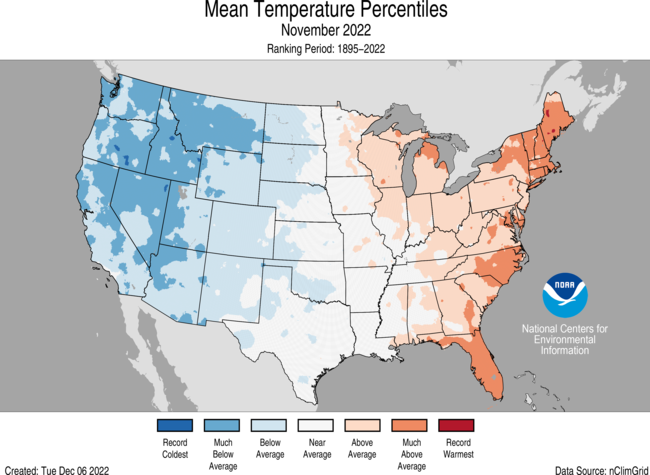
The average temperature of the contiguous U.S. in November 2022 was 41.0°F, which is 0.7°F below average, ranking in the middle third of the record. Generally, temperatures were above average from the Midwest to the Northeast and Southeast, and below average from the Plains to the West Coast.
November precipitation for the contiguous U.S. was 2.40 inches, 0.17 inch above average, ranking in the middle third of the historical record. Precipitation was above average from the Great Lakes to the southern Plains, from the Gulf Coast to the Northeast and across portions of the Great Basin, northern Rockies and northern Plains. Precipitation was below average across southern Michigan to the Ohio Valley and in the central Plains.
Parts of the Pacific Northwest had their coldest November in nearly four decades. Washington State observed its coldest November since 1985. Oregon saw its coldest November since 1994 and Idaho had its coldest November since 2000.
Hurricane Nicole became the first hurricane in nearly 40 years to make landfall in the United States in November.
According to the November 29 U.S. Drought Monitor report, about 57.5% of the contiguous United States was in drought. Severe to exceptional drought was widespread from the Great Basin to the Pacific Coast, across much of the Great Plains to Mississippi Valley, and in parts of Hawaii, with moderate to severe drought in parts of the Southeast and Northeast.
Other Highlights:
Temperature
For the month of November, Maine ranked fifth warmest on record while Florida ranked seventh warmest, with five additional states experiencing a top-10 warmest November on record. Conversely, temperatures were below average to record coldest across much of the West. Idaho ranked fourth coldest, Washington ranked sixth and Oregon ranked seventh, while two additional states each had their top-10 coldest November on record.
The meteorological autumn (September-November) average temperature for the Lower 48 was 54.7°F, 1.2°F above average, ranking in the warmest third of the record. Temperatures were above average from the West Coast to the Great Lakes and into the Northeast as well as along portions of the East Coast. Temperatures were near- or below-normal in parts of the Southwest, the southern Plains, and from the southern and central Mississippi Valley to the Ohio Valley and Southeast. Maine ranked fourth warmest while five additional states ranked among their warmest 10 autumn seasons on record.
For the January-November period, the average contiguous U.S. temperature was 55.2°F, 1.5°F above average, ranking 17th warmest in the 128-year record. Temperatures were above average from the West Coast to the Gulf Coast and from the Gulf to New England. California and Florida each ranked fifth warmest while Massachusetts and Rhode Island each had their sixth warmest January-November period on record. Five other states ranked among their warmest 10 year-to-date periods on record. Temperatures were near average from the northern Plains and Upper Midwest to the Tennessee Valley.
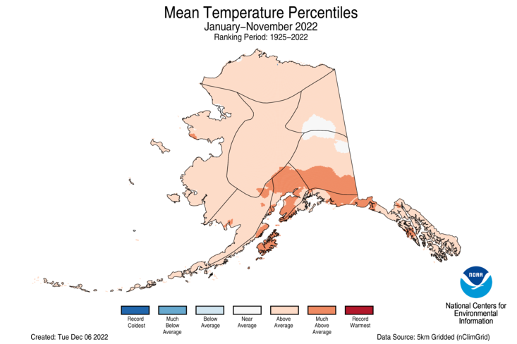
The Alaska statewide November temperature was 16.3°F, 4.6°F above the long-term average. This ranked in the warmest third of the 98-year period of record for the state. Temperatures were above average across much of northern Alaska, the Yukon Delta, the Aleutians and parts of the eastern Interior. South central Alaska and areas along the Gulf of Alaska to the Panhandle experienced near-average conditions, while the southern Panhandle experienced below-average temperatures for the month.
The Alaska autumn temperature was 29.2°F, 3.3°F above the long-term average, ranking 18th warmest on record for the state. Temperatures were above average across most of the state with the central Interior region near average for the season.
The Alaska January-November temperature was 30.7°F, 2.7°F above the long-term average, ranking 15th warmest on record for the state. Above-average temperatures were observed across the vast majority of the state for this 11-month period.
Precipitation
November precipitation was near- to above-average over much of the contiguous U.S. Precipitation was below average in parts of the Southwest, central Plains, Ohio Valley and Great Lakes. No state experienced a top-10 wettest or driest November.
The U.S. autumn precipitation total was 5.92 inches, 0.96 inch below average, ranking in the driest third portion of the September-November record. Precipitation was above average across parts of the Rockies, Southwest and East Coast. Precipitation during September-November was below average along the West Coast and from the northern and central Plains to the Great Lakes and Ohio River Valley. Nebraska ranked fifth driest while four additional states experienced a top-10 driest autumn season on record.
The January-November precipitation total for the contiguous U.S. was 25.61 inches, 1.98 inches below average, ranking in the driest third of the historical record. Precipitation was above average across portions of the Northeast, Great Lakes, Ohio Valley, southern Mississippi Valley, and in parts of the Rockies and Northwest. Precipitation was below average across much of the West, central and southern Plains and parts of the East Coast during the January-November period. California ranked second-driest on record while Nebraska ranked fourth driest and Nevada ranked 11th driest for this 11-month period.
Monthly precipitation averaged across the state of Alaska was 3.37 inches, 0.02 inches below average, ranking in the middle third of the 98-year record. Conditions were wetter than average across the North Slope, central Interior, West Coast and in portions of the Aleutians while much of eastern Alaska and northern parts of the Panhandle experienced near-average conditions. Southern areas of the Panhandle had below-average precipitation for the month.
For the autumn season, precipitation ranked 12th wettest across Alaska with wetter-than-average conditions observed across most of the state. Parts of the central Interior, Aleutians and southern Panhandle experienced near average precipitation for this period.
The January-November precipitation ranked second-wettest on record for Alaska, with above-average to record high precipitation observed across much of the state. The central and northeast Interior regions were near-average while much of the Aleutians experienced below-average precipitation for this period.
Other Notable Events
November had several notable storms that brought severe thunderstorms and tornadoes to portions of the United States:
On November 4-5, a tornado outbreak occurred across portions of Texas, Oklahoma, Louisiana and Arkansas. A total of 31 tornadoes were confirmed by the National Weather Service, including two EF-4 tornadoes, which brought significant damage to the region including mass power outages.
On November 29-30, severe storms and tornadoes swept through parts of the South, downing trees, damaging homes in parts of Alabama and Mississippi. The National Weather Service confirmed 11 tornadoes during this outbreak including two EF-3 tornadoes.
On November 10, Hurricane Nicole made landfall along Florida’s eastern shore, flooding the coast and knocking out power to thousands. Nicole was the first hurricane to hit the United States in November in nearly 40 years.
On November 7-10, a winter storm brought heavy snow and strong winds across much of the West. Parts of Washington, California, Montana and North Dakota reported between one to three feet of snow.
A historic snowstorm slammed western and northern New York on November 16-20 with more than six feet of snow reported in some areas, closing roads, triggering driving bans and canceling flights. The city of Buffalo set a record for daily snowfall, with 21.5 inches on Saturday, November 19. The previous record was 7.6 inches. The State Climate Extremes Committee is investigating whether or not a new New York state 24-hour snowfall record has been set.
Drought
According to the November 29 U.S. Drought Monitor report,about 57.5% of the contiguous U.S. was in drought, down about 5.3% from the beginning of November. Drought conditions expanded or intensified across portions of the Southeast, Great Lakes, Upper Midwest and central Plains. Drought contracted or was eliminated across portions of the Northwest, northern and southern Plains, Mississippi Valley and parts of the Northeast and Hawaii.
According to the One-Month Outlook issued on December 1 from the National Interagency Fire Center, the contiguous U.S. and Alaska are expected to be near normal while the islands of Hawaii have above normal significant wildland fire potential during December.
Upper Colorado River basins. (The border of Wyoming and Colorado is mislabeled.) (U.S. BOR)
Click the link to read the article on the KUNC website (Alex Hager). Here’s an excerpt:
As climate change continues to shrink the Colorado River’s largest reservoirs, a group of four states that use its water are set to lay out plans to reboot a conservation program. The Upper Colorado River Commission – comprised of Colorado, Utah, Wyoming and New Mexico – plans to announce details of an extended “System Conservation Pilot Program” through which water users could be paid to cut back on their use. The soon-to-be-launched program aims to use a pool of $125 million from the Inflation Reduction Act for payouts to “mitigate the impacts of long-term drought and depleted storage,” according to presentation slides obtained by KUNC…The new program is an extension of a previous effort. An earlier pilot program ran from 2015 through 2018. Designed to serve as a proof of concept, the UCRC distributed more than $8.5 million as a part of that program and conserved an estimated 47,207 acre-feet of water…
The 2023 program would allocate considerably more money than the prior iteration if the UCRC gets approval from Congress to extend the program. The proposed Colorado River Conservation Act authorizes the program to continue until 2026. The Bureau of Reclamation would also need to sign off on the use of $125 million in federal funds. The money will come out of $4 billion from the Inflation Reduction Act that was set aside for Colorado River projects.
Chuck Cullom, executive director of the Upper Colorado River Commission, said his agency is still sorting out how much money it will offer water users on a per-acre-foot basis in exchange for cuts, and does not have a target for a total amount of conservation. The Upper Colorado River Commission is slated to release its first request for proposals on December 14, with a deadline in February. Then each participating state, and the UCRC will be able to review each water-saving proposal, setting higher payout values on a case-by-case basis. Cullom said the intent of such a review is to discourage profiteering, a nagging concern of programs that pay water users to cut back.
Studies of the 2015 pilot program found that lingering uncertainties still surround programs that pay farmers for temporarily fallowing their fields to conserve water. Questions about pricing, soil health, monitoring and ensuring that conserved water reaches the beleaguered Colorado River reservoirs remain unanswered…Cullom said the Upper Colorado River Commission expects to make a formal announcement about 2023 system conservation plans in Las Vegas. The commission will hold a meeting during the Colorado River Water Users Association annual conference, a yearly meeting of policymakers, scientists and water users that has been under increasing scrutiny as the region’s supply-demand imbalance teeters towards crisis levels.


