Proposed Lake Nighthorse recreation plan update

A picture named lakenighthorsesummer2010

From the Durango Telegraph (Leslie Swanson):

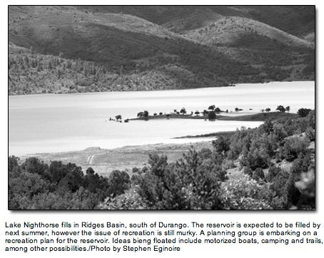
Smoothing out as many wrinkles as possible is the goal of Lake Nighthorse recreation planners. Public acceptance is, they say, a key component of the plan’s success. To that end, they have made participation in the decision-making process available through open houses, public forums, design workshops and a website where people can post comments and see everyone else’s as well. A review of public opinions expressed so far reveals that most people are willing to compromise on motors. Of all the comments received by DHM Design, the reservoir’s primary planning entity, 22 voted for no motors at all, 37 supported unrestricted motorized sports, and 38 were OK with some form of engine, as long as they are limited in horsepower, area and/or schedule. An electric-only restriction on motors was very popular among the latter group.

Joy Lujan, of the National Park Service, has been facilitating the public planning process. She explained that they are approaching a resolution by dealing with the individual components of anti-motor sentiments: primarily noise, pollution and wakes. By designating separate areas, restricting engine decibels, banning fueling stations and inspecting boats for invasive mussels, the lake’s planners believe that they can resolve anti-motor issues. The two ends of the sporting spectrum can4 peacefully co-exist, they claim, but no gas motors at all? That’s looking like a no-go.

Here is where the water gets choppy: With all the outreach and open access of the current planning process, one large and lasting decision appears to have been made with very little public input – construction of the boat ramp. Paid for by a Wallop-Breaux grant of $3 million from the State of Colorado, the ramp came with a contingency: it must allow use by gas-powered boats within three years of completion or the Bureau of Reclamation has to return the money. At a public forum last November, a bureau representative stated that repayment was not likely, in effect making motorized boating a done deal regardless of opposition. Such mandates tend to stir discontent and mistrust, and the boat ramp has caused significant local agitation.

Mark Chiarito, of the Bureau of Rec, expressed desire to resolve the confusion and offered the following explanation about the decision to construct the boat ramp: “In order to open the reservoir to public use in a timely manner, the Bureau of Reclamation and the State agreed on the need to solicit interest from other nonfederal entities to provide recreation at Lake Nighthorse. Hence, the current community planning process is being conducted and the boat ramp needs to be considered as a valid existing facility for inclusion in the recreation master plan.”

More Animas River watershed coverage here.

Proposed MOU between the Archuleta County Board of Commissioners and the Pagosa Area Water and Sanitation District scrapped by county

A picture named sanjuan.jpg

From the Pagosa Sun (Randi Pierce):

Commissioner John Ranson expressed that, while he was disappointed that the time and effort given to the MoU did not pay off, he believes the withdrawal of the agreement was the right move. “I think it’s exactly the right thing they should have done,” Bunch said in a Wednesday interview. “It gets things back on the basis it should have been on since day one … We are two separate managerial agencies that need to take care of our business.”

A rift between the BoCC and PAWSD began in the fall of 2009, when the BoCC began requesting financial documents from PAWSD, expressing concerns over PAWSD’s spending, Dry Gulch Reservoir assumptions, service plan and more. The rift then deepened last March, when the BoCC began requesting that PAWSD provide the county with an annual report.

The two boards met in a public meeting in March 2010, where the idea of an agreement or memorandum of understanding between the two boards was mentioned by PAWSD Attorney Jim Collins.

More Pagosa Springs coverage here and here.

Montezuma County water history

A picture named montezumatunnelsteelarches.jpg

Here’s an in-depth look at the history of water projects in Montezuma County, from Reid Wright writing for the Cortez Journal. Click through and read the whole thing. Here’s an excerpt:

The town of Cortez was first founded in December of 1886 near Mitchell Springs by officials of the Montezuma Valley Water Supply Company, led by James W. Hanna. “It was not enough water at that time,” [Montezuma Valley Irrigation Company President Randy Carver] said. “As a matter of fact, a barrel of water at that time was 50 cents.”

The officials filed a claim for 1300 cubic feet per second of water from the Dolores River, which they planned to deliver through a tunnel to irrigate 200,000 acres and provide water for an expected Cortez population of 50,000. “The plan was particularly optimistic,” Carver said.

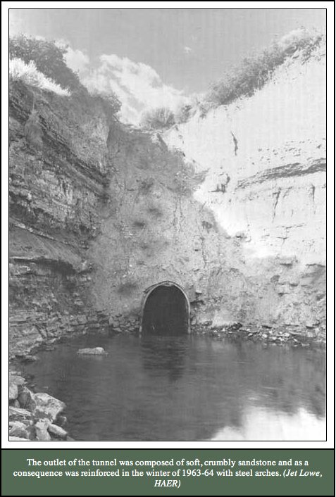
Work began in 1887 on a 5,400 foot long tunnel to bring water from the Dolores River into the Montezuma Valley basin, Carver said. Although railroad tunnels would be built in the coming decades, it was unusual at that time for tunnels to be built for water. “This was a very significant project in the United States,” Carver said. “It was considered one of the greatest irrigation enterprises.” The tunnel was not lined and after repeated cave-ins in 1863 and 1864, steel arches were installed to shore up the sandstone.

The first feasibility study on the [McPhee dam and reservoir] was completed in 1942 by the U.S. Bureau of Reclamation, according to information on the agency’s Web site. However, Congress would not authorize the project until 1968 and would not allocate funding for the project until 1976. The project came under fire from President Jimmy Carter, who placed it on a “hit list” of 19 Western water projects up for funding cuts. Ultimately, Carter relented due largely to a 1908 U.S. Supreme Court ruling that required the government to provide water to the Ute Mountain Ute Tribe in exchange for large tracts of land previously relented by the tribe, Ground was broken on the project in September of 1977 and would endure numerous technical setbacks as well as threats of funding loss. Three people died in accidents related to construction of the project.

The McPhee Dam and Great Cut Dike were completed in 1984 at a cost of more than $99.5 million and the new Dolores Tunnel was completed in 1985 at a cost of more than $12 million. Tens of millions were spent on pump stations, canals and hydroelectric power plants. With the irrigation system, the Dolores Project now provides an annual average of 90,900 acre feet of water to Montezuma County, Dolores County and the Ute Mountain Ute Reservation. It generates an annual average of more than 36.5 kilowatt-hours of electricity, the reclamation Web site states.

More Montezuma County coverage here and here.

USGS: Simulation of Hydraulic Conditions and Observed and Potential Geomorphic Changes in a Reconfigured Reach of Muddy Creek, North-Central Colorado, 2001–2008

A picture named muddycreekoutfallwolfordmountainreservoir.jpg

Here’s the link to the report. From the USGS website:

Muddy Creek near Kremmling, Colorado, is a regulated, meandering, gravel-bed stream that has been monitored for geomorphic change since 2001. One reach of the creek was reconfigured using natural-channel design methods in 2003, providing an opportunity to compare hydraulics in this reach with those in a nearby, unaltered control reach. Streamflow in Muddy Creek has been regulated by Wolford Mountain Reservoir since 1995, but reservoir releases in 2006 and 2008 resulted in out-of-bank floods. The Muddy Creek monitoring program was conducted by the U.S. Geological Survey from 2001 to 2008 in cooperation with the Colorado River Water Conservation District, and the streamflow modeling and analysis were conducted in 2008 in cooperation with the Colorado River Water Conservation District and the Colorado Water Conservation Board.

Minor changes in channel geometry were measured at monitored cross sections in the control reach between 2001 and 2008 and in the reconfigured reach between 2003 and 2008. Geomorphic changes were limited to lateral erosion in a meander bend and lateral erosion of an alluvial fan that formed a vertical scarp in the control reach. Some excavated streambed locations in the reconfigured reach have aggraded to their former elevations, and gravel on alluvial bars might have become better sorted and winnowed of sand-size sediment. Hydraulic conditions in the reconfigured and control reaches were simulated using the U.S. Geological Survey MD_SWMS framework and FaSTMECH computational models.

Elliott, J.G., Schaffrath, K.R., McDonald, R.R., Williams, C.A., and Davis, K.C., 2011, Simulation of hydraulic conditions and observed and potential geomorphic changes in a reconfigured reach of Muddy Creek, north-central Colorado, 2001–2008: U.S. Geological Survey Scientific Investigations Report 2010–5183, 43 p.

More Colorado River basin coverage here.

Snowpack news

A picture named snowpackcolorado03042011

From The Aspen Times via the Snowmass Sun:

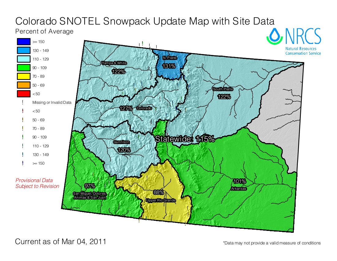
The Roaring Fork basin as a whole was at 127 percent of average on Thursday — the same as it was on Feb. 2. The NRCS measures snowpack in seven places in the Roaring Fork basin. The Independence Pass site was at 123 percent of average. Three sites in the Fryingpan River drainage ranged from 122 percent to 142 percent of average. Three sites in the Crystal River drainage ranged from 124 percent to 137 percent of average. The statewide average was 115 percent as of March 1, the NRCS reported. That bodes well for irrigators, anglers and rafters…

Snowfall was spotty in Colorado during February. Snowpack totals in the Sangre de Cristo Mountains and the Rio Grande River basin improved significantly after they got their first big storms of the season. Nevertheless, the Rio Grande’s snowpack was only 88 percent of average. In other parts of the state, a dry February ate into the snowpack. The San Juan, Animas, Dolores and San Miguel basins saw their snowpacks fall below average for the first time this winter. Other parts of the state had closer to average snowfall during February, so their snowpack remained above average.

Arkansas Basin Roundtable public outreach meeting recap

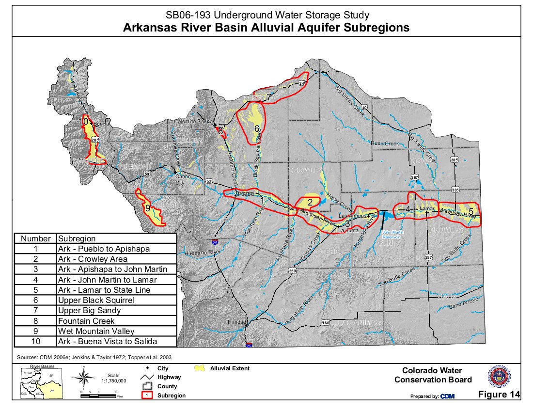
A picture named arkansasbasinalluvialaquifersubregions.jpg

From the La Junta Tribune Democrat (Bette McFarren):

Kevin Karney welcomed the group, which was small but deeply concerned with water issues. He then turned over the moderator’s duties to Professor Perry Cabot of Colorado State University, a man of many farm and water projects, some funded by the Colorado Water Conservancy through the Arkansas Valley Roundtable. All of the projects underway from the roundtable are referred to during the presentation as IPP’s (Identified Projects and Processes)…

Bill Wargate of the Applegate group also addressed the gathering. He predicts a gross gap for each provider. The factors are summer homes in Chaffee and Fremont counties, the Telluride-Victor mines, Custer County, Round Mountain, and a big change in El Paso County. The gap for El Paso County is 22,600 acre- feet.

More IBCC — basin roundtables coverage here.

Basin Roundtable Summit: Alternative ag transfers

A picture named rockyfordditch.jpg

Here’s a wrapup of the summit afternoon session dealing with alternative ag transfers, from Chris Woodka writing for The Pueblo Chieftain. From the article:

It turns out the Arkansas Valley provides front-row seats for a lot of the new ideas. The state is working on several fronts to keep the thirst of cities from drying up farmland in Colorado more than it already has. In some cases, such as the Rio Grande basin, farmers themselves are finding they need to throttle back their use of water to avoid tapping out the available supply. A panel talking about the issue of alternative transfers reached the conclusion that the solution to stretching the water supply differs in each of the state’s basins. However, most of the ideas presented Thursday are already beginning to play out in the Arkansas River basin…

[Engineer Louis Meyer] advocated for watershed protection through a utility fee for urban users, saying water users in cities could pay to keep farmland productive. He cited conservation easements as one method to achieve this, and he voiced the need to have local food sources as the primary reason. “We need surcharges to protect the watersheds,” Meyer said. “Why don’t we have a surcharge to help ranchers in the upper part of the basin?”[…]

The Greeley board is concerned both about providing enough water for the region — Weld and Larimer counties will have 1.2 million people by 2050 — and agriculture, which is a $1.4 billion industry in Weld County, the state’s top producing county. Greeley has purchased water from area farms and has been leasing it back to farms for 20 years already. “What we face in our area and statewide is how to maintain a sustainable economy,” Evans said.

Tied into all of the decisions being made in all of the state’s basin is the way rivers work. Shutting off water in one place often means consequences for downstream users. Return flows, the water applied to fields that is not used by crops to make its way back to the river, are part of the equation. In the South Platte, for instance, water is used and reused six times before reaching the Nebraska state line. “One person’s inefficiency is another person’s water right,” [Joe Frank, manager of the Lower South Platte Water Conservancy District] said…

“One size doesn’t fit all,” observed Eric Kuhn, manager of the Colorado River Conservancy District. “But, maybe one size constrains all.”

More IBCC — basin roundtables coverage here.

A Sustainable Solution for Meeting Colorado’s Water Needs Through 2050

I first reported about this report on Wednesday. Here’s an analysis from Alan Prendergast writing for Westword. Click through and read the whole article. Here’s an excerpt:

The challenge is daunting. The population of eleven Front Range counties is expected to swell by another 2.5 million people by 2050, pushing municipal water needs to more than a million acre-feet of water a year. That’s about 365,000 acre-feet more than the available supply. But Filling the Gap makes the case for pragmatic planning now rather than panic later.

Some additional dams and diversion projects are deemed acceptable by the report’s authors. But the Upper Colorado River Basin is already quite stressed by the Moffat, Windy Gap and Colorado-Big Thompson projects, leaving anemic streams and declining water quality. Fully two-thirds of the native waters from the region are drained into the Front Range these days, and city planners have their eyes on much more.

But the new study calculates that much of the increasing demand can be met through common-sense conservation strategies, better cooperation among agricultural and municipal interests, and other measures that don’t involve tapping deeper into overextended supplies.


Edwards: Eagle Valley chapter of Trout Unlimited general membership meeting March 8

A picture named eagleriver.jpg

From the Eagle Valley chapter of Trout Unlimited via the Vail Daily:

The Eagle Valley chapter of Trout Unlimited will hold a general membership meeting Tuesday, featuring a film, “Grand Canyon Adventure: River at Risk,” by MacGillivray Freeman Films. The meeting will be held at Berry Creek Middle School in Edwards. The film celebrates the Colorado River and potential water shortages in the west by year 2050. The film uses the Colorado as a metaphor for what’s happening all over the world and as a way to show how delicate water systems can be and how everything is interconnected. The meeting is open to the public and will also cover annual Eagle Valley Trout Unlimited membership business, awards presentations and giveaways.

The meeting is scheduled from 6-8 p.m. and is open to the public. To learn more, call 970-470-1844 or e-mail alex@eaglevalleytu.org.

More Eagle River watershed coverage here and here.

Basin Roundtable Summit

A picture named ibccroundtable.jpg

The Interbasin Compact Committee, the Colorado Water Conservation Board and the Colorado Foundation for Water Education hosted a summit for the basin roundtables yesterday in Westminster. Discussion centered around the IBCC strategy report drafted and sent to Governor-elect Hickenlooper last fall that identifies four approaches — conservation, alternative ag transfers, identified projects and new supplies — for solving Colorado’s anticipated water supply gap.

I didn’t make the morning sessions but Chris Woodka from The Pueblo Chieftain was there. Here’s his report. From the article:

[Governor Hickenlooper said], “The next four or five years . . . this is the point in Colorado history where we have a chance to get this done,” Hickenlooper told the Roundtable Summit. “We can find a long-term solution for the state’s water future.”

The summit is the first gathering of members from all nine basin roundtables formed as part of the Interbasin Compact Committee process in 2005. About 300 attended the meeting. Hickenlooper said the state should increase conservation, protect the environment, encourage agriculture and develop water supplies — all goals in an IBCC framework to deal with the state’s water. The state should cut red tape to allow water projects to move ahead and remain open to private investment.

The question of private investment was posed by Jeris Danielson, a member of the Arkansas Basin Roundtable and a former state engineer. Danielson also is a consultant for Aaron Million, who has proposed building a multibillion-dollar pipeline from Flaming Gorge Reservoir in Wyoming to serve Colorado’s Front Range. “To solve the state’s water problems takes money,” Danielson said, and noting that state and federal governments are running low on cash. “Are you willing to work with private developers?”

“We have to be careful bringing in private capital as part of the solution,” Hickenlooper said. “I don’t have a problem with bringing private capital into the picture, but we need to make sure their goals line up with the state’s goals.”

Hickenlooper pledged to keep water funds whole with the entire state picture in mind. Water funds in the past two years have been raided to balance other parts of the state budget.

The group then broke up for table discussions facilitated by the IBCC members to brainstorm implementation of the IBCC strategy document.

At the concluding session IBCC Director, John Stulp, summarized some of the themes that came out of the table discussions:

“We favor keeping people from dying from thirst, we do not support lawn watering.”

“Some think that conservation should be mandated” (Stulp quipped, ” We don’t always agree on everything.”)

“How do we develop a water market?”

“Is there a need to increase infrastructure for both agricultural and municipal systems to facilitate alternative ag transfers?”

Stulp, farmer and former director of the Colorado Department of Agriculture, mentioned that he had recently read that civilization, “must produce as much food in the next 40 years as we have in the last 10,000 years.”

More coverage from The Denver Post (Bruce Finley). From the article:

“It doesn’t have to be a trade-off if we’re smart and figure out how to do this in an equitable manner,” said T. Wright Dickinson, a rancher on the 27-member board charged with finding a statewide water solution. Thursday’s forum of the Inter basin Compact Committee marked the first time representatives from nine river basins have confronted their task together in a process state lawmakers launched in 2005…

“We can obtain a fair amount of water supply from conservation and re- use,” said Mark Pifher, Aurora Water’s director and chairman of the Front Range Water Council. “But as a state we need to look at water available in the Colorado River Basin and develop it to the extent of our (interstate) compact entitlement.”[…]

Rod Kuharich, director of the South Metro Water Supply Authority, which represents 15 suburbs dependent on groundwater wells, said the goal would require “draconian” enforcement and said 300,000 acre- feet would be more realistic. “Is this really a role the state government should be playing? To control your water use? I fear trees dying,” Kuharich said. “When you start to limit the amount of lawn irrigation, the existing landscape is going to change. You’d need to provide a water source for those trees.”

During an afternoon session dealing with non-consumptive use a panel discussed successes that have been realized over the past few years. The big problem, according to Colorado Basin Roundtable member, Caroline Bradford, is quantifying the non-consumptive needs of wildlife and riparian environment. It will take time to do the science and there is not enough effort and funding, she says.

A representative from Colorado Ducks Unlimited spoke about recharge/habitat projects on the Lower South Platte River.

A project with the town of Brush for example, “Runs water to 600 acres of wetlands.” The Colorado Department of Wildlife leases the land from Brush, and, “We get a lot of Ducks off that property.” The cost per acre foot for Brush is around $17 he said.

Speaking generally he said, “Landwoners love it,” wetlands increase land value, create a better place to hunt and add a fair amount of ag production as well.

I’m not sure if any of the walls between basins are coming down but it is apparent that the roundtable members are more focussed on solutions rather than protecting parochial interests. It’s taken 5 years to get to this point and now they have 5 years to develop a plan to meet the gap.

Bump and update From The Durango Herald (Joe Hanel):

Just five years ago, the east-west tension about water was so potent that no one could have contemplated such a gathering. But on Thursday, Gov. John Hickenlooper charged the water experts with developing a statewide solution that will overcome regional water conflicts. “This is the point in Colorado history when we have an opportunity to get this done, to actually have a long-term sustainable vision for our water,” Hickenlooper said.

Colorado never has had a statewide water strategy. Instead, growing cities buy water from farmers and the dry eastern side pumps it through controversial tunnels from the Western Slope. Most water experts agree that without changes, cities will dry up the farms and mountain valleys…

A statewide water roundtable known as the Interbasin Compact Committee released a controversial report in December that dominated Thursday’s agenda. The report calls for a greater role for state government in water policy, both in mandating strict conservation for cities and in speeding up the slow process of building major water projects.

Reaction to the report has been mixed. Some people complain the conservation requirements are not strict enough, while others say they are too strict, including a proposed new law that homeowners install water-efficient appliances before they sell their houses. People from Western Slope river roundtables have said that even if the state requires cities to pay extra for water transfers, no amount of money is enough to compensate for the loss of water, according to a written summary of comments gathered the last two months at public meetings around the state.

More IBCC — basin roundtables coverage here.

Snowpack news

A picture named nrcssnowpackstorage03012011

From the Natural Resources Conservation Service (Mike Gillespie):

The latest surveys of Colorado’s mountain snowpack indicate continued favorable conditions for next spring and summer’s water supplies. According to snow surveys conducted by the USDA-Natural Resources Conservation Service (NRCS), the statewide snowpack continues this year’s trend of above average conditions and is 115 percent of average as of March 1. Basinwide snowpack totals are above average across most of the state with the only basins reporting below average conditions confined to the river basins in southern Colorado, according to Allen Green, State Conservationist with the NRCS.

Probably the most significant aspect of February’s weather events was the overall improvement in areas of the state, which up until this month, had been fairing quite poorly. Snowpack totals in the Sangre de Cristo Mountains and throughout the Rio Grande River Basin improved significantly this month, yet snowpack totals remain below average throughout this region. For many measurement sites in this area these February storms were the first significant snowfalls of the year. The Rio Grande Basin snowpack totals have the lowest basinwide snowpack percentage in the state at 88 percent of average.

In those basins west of the Continental Divide, snowpack totals decreased for the second consecutive month in February. Across the San Juan, Animas, Dolores and San Miguel basins, these decreases were large enough to lower the percentages to below average for the first time this year. Elsewhere across the state, particularly across the northern basins, these declines were less severe leaving snowpack percentages at above average levels.

The latest surveys once again illustrate the strong disparity between this year and last year’s snowpack conditions. With this year’s snowpack totals well above those of last year in most basins, only southwestern Colorado continues to report less snowpack than last year at this time. Statewide totals remain well above those measured on March 1, 2010.

Now, with only about one-quarter of the winter snow accumulation season remaining, most of the state can bank on seeing average to above average spring and summer runoff. The outlook for water supplies remains good to excellent across the Yampa, Colorado, South Platte Gunnison and Arkansas headwaters. “About the only basins likely to see below average runoff this year are the Rio Grande, the southern tributaries of the Arkansas River, and the southwestern basins”, said Green. The one advantage in the San Juan, Animas, Dolores and San Miguel basins lies with their slightly above average reservoir storage which will help to supplement expected lower water supplies.

Click on the thumbnail graphic above and to the right for the NRCS table of snowpack and reservoir storage levels by basin.

More coverage from Bill Jackson writing for The Greeley Tribune. From the article:

Adding to concerns is the latest outlook for March-May by the National Oceanic and Atmospheric Administration Climate Prediction Center. That outlook calls for a more than 33 percent probability of above-normal temperatures and below-normal precipitation, which does not bode well for the state’s Eastern Plains. Some areas have received decent moisture, but dry conditions, particularly in the southeast part of the state, could result in wildfires this spring and summer, NOAA said…

But the latest statewide surveys by officials with U.S. Department of Agriculture’s Natural Resources Conservation Service, indicate continued favorable conditions for the spring and summer water supplies, said Allen Green, state conservationist with the NRCS in Denver. The state’s snowpack is 115 percent of the long-term average as of March 1 and is 131 percent of last year’s numbers on the same date. The four main basins in the northern mountains, however, range from 121 percent of average on the South Platte to 131 percent on the North Platte. Compared to last year, however, the four basins — which includes the Colorado and Yampa/White — are at 153-183 percent of 2010…

The northern snowpack means there probably will be more water coming off the snowpack than can be stored in Lake Granby. That lake is the primary storage facility of the Colorado-Big Thompson Project, which brings a supplemental water supply over the mountains to 30 cities and towns in northeastern Colorado along with irrigation water for about 693,000 acres of farmland. Brian Werner, spokesman for Northern Water, which manages the Colorado-Big Thompson, said two meetings already are scheduled with the U.S. Bureau of Reclamation next week to the determine the best options for Lake Granby. “The simple math is that there’s going to be too much water coming into the collection system on the Western Slope this spring than we can either store and/or bring over to the east side,” Werner said. Letting water out of Granby back into the Colorado River could begin within the next couple of weeks to make room for at least some of the expected runoff this spring.

From the Summit County Citizens Voice (Bob Berwyn):

The March 1 anowpack in the Colorado River Basin was at 128 percent of normal, near the level it’s been at all year, and local weather watcher Rick Bly reported above-normal precipitation total for February to add to that total. For the month, Bly tallied 26.3 inches of snow, 11 percent more than the historic average of 23.5 inches. Melted, that snow added up to 1.85 inches of water, about 8 percent above the average 1.71 inches for the month.

For the year-to-date, total snowfall at Bly’s Breckenridge weather station is 136.1 inches, well above the year-to-date average of 101.5 inches and surpassing last year’s total winter snowfall of about 126 inches — but far from any records. As recently as 1995-96, 220 inches of snow had piled up in Breckenridge by March 1. The snowpack water-equivalent for the year-to-date at Bly’s gauge is 11.15 inches, a whopping 41 percent above the historic average of 7.52 inches. And that’s with the snowiest month yet to come, Bly said, adding that March has historically been reliable for steady snowfall, even in many otherwise dry years. The average snowfall for March is 25.52 inches and the biggest March on record was in 1899, with 120.4 inches — that was the winter that Breckenridge residents had to tunnel their way down Main Street. In the modern era, one of the biggest Front Range storms on record spilled over the Continental Divide to deliver 47.5 inches in March 2003. That was the storm that began on St. Patrick’s Day and dropped more than 80 inches on Evergreen, triggering avalanches near Georgetown and shutting down I-70 for several days.

Salida: Water rate increases coming?

A picture named waterfromtap.jpg

From the City of Salida:

A draft water rate study recently completed by the city’s engineering firm Schmueser Gordon Meyer (SGM) is now available for review on the city’s website. The study indicates rates are well below the required level to pay for the cost of the plant and water system. Alternatives for increasing rates will be considered by the council at the regular meetings scheduled on March 1 and March 15. Public comment may be considered at both meetings; however, the official public hearing will be held as part of the March 15 meeting.

For well over a year now, city staff and elected officials have discussed the need to increase water rates to keep up with costs. The fund is not breaking even and reserves are depleted.

Water service is provided to residents and property owners in Salida through an enterprise fund. This accounting structure is used for business-type activities. Water operations are not operated as a governmental fund supported by tax dollars. Revenue generated from the business activity (providing water) needs to be sufficient to pay for that activity.

The City has followed a revenue model whereby quarterly fees paid for operations and routine maintenance or upgrades. Development fees paid for capital improvements and debt service on those improvements. In recent years, revenue has not kept pace with the capital needs and debt service requirements. The City made substantial investments in capital infrastructure including the high zone water tank, new transmission lines, upgrades to the treatment plant, purchase and installation of radio-read meters and acquisition of water rights. Strong development activity in the mid 2000’s paid for a substantial portion of the capital improvements; however, it was not sufficient to fully pay for all such improvements. In addition, aging facilities are continuing to require upgrades and maintenance to extend their service period. Development has now slowed substantially and is not sufficient to pay existing debt service or cover capital requirements. In 2010, we used up capital reserves and obtained a commitment for additional debt to pay for capital improvements of the galleries water tank. Future capital requirements need to be paid by fees for water service.

Last year the city contacted its engineering firm, Schmueser Gordon Meyer (SGM), about completing an assessment of future capital needs and a rate study. The capital improvement plan is still being finalized and will be incorporated into the final draft of the rate study.

The city plans to raise rates to generate sufficient revenue to pay for current operating expenditures, debt service and capital requirements. Future development fees will be used to begin rebuilding reserves. The goal is to operate the water system efficiently and design a rate structure whereby users of the water system share in its costs of operations in a fair and equitable manner. No one welcomes rate increases, but the city needs to cover costs.

More Arkansas River basin coverage here.
Southern Delivery System update

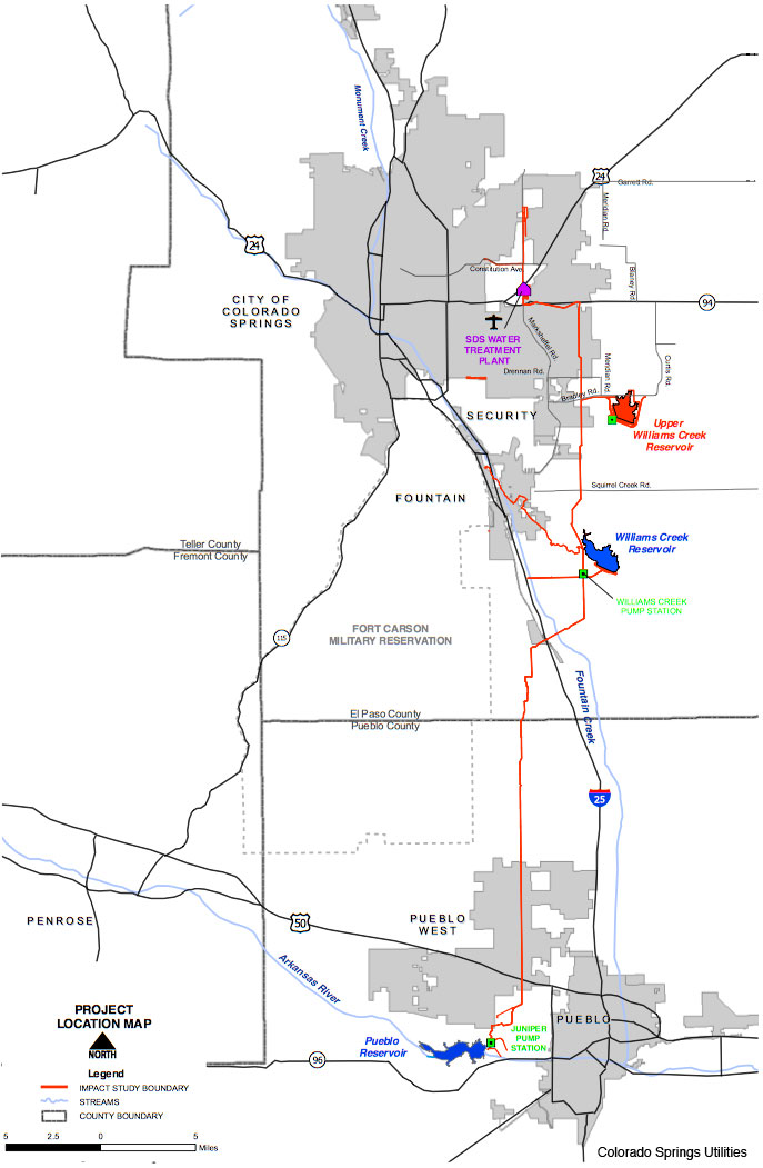
A picture named sdspreferredalternative.jpg

Here’s an in-depth look at the problems Colorado Springs Utilities faces in acquiring easements for the pipeline, from Pam Zubeck writing for the Colorado Springs Independent. From the article:

So far, Utilities has secured 126 signed agreements of the 170 needed in Pueblo County. That leaves 44, including 13 in Pueblo West, which covers nearly 50 square miles and is home to roughly 32,000 people. While 120 property owners in Pueblo West signed on the dotted line without raising a stink, Maxwell and 11 others refused — and face condemnation of their land after a stalemate in negotiations triggered Colorado Springs City Council last week to authorize court action. This isn’t the first time Springs Utilities has gone to court over SDS. Previous legal bills tally $2.7 million of the $115.5 million spent on SDS as of Dec. 31. Those costs include a dispute over Pueblo County’s ability to impose construction guidelines on the project. (Pueblo County won.)

Now Utilities will pay more legal bills for eminent domain — the public taking of private property for a public purpose, for fair compensation — though officials say they’d rather not. “Our intent is to try to find common ground without going to court,” says SDS planning and permitting manager Keith Riley…

If and when Utilities drives the line through Pueblo County, the job is only half-done. The city needs 130 parcels in El Paso County but so far has acquired only 43.

Meanwhile CSU has appointed Gary Bostrom to lead the utilities water sector. Here’s a report from the Colorado Springs Independent. From the article:

Gary Bostrom, general manager for Colorado Springs Utilities’ planning, engineering and resource management in water services, will take over as top water officer, vacated by the promotion last fall of Bruce McCormick to chief energy officer. Bostrom has spent his entire career at Springs Utilities and now takes over a water system that includes 25 reservoirs, more than 1,700 miles of distribution pipe, seven water treatment plants and a transmountain raw water system. He also oversees the city’s wastewater treatment and collection system. A Springs native, Bostrom received a 15 percent pay bump, to $224,390 a year, to assume his new role.

More Southern Delivery System coverage here and here.

Snowpack/runoff news

A picture named snowpackcolorado03022011

From the Fort Collins Coloradoan (Bobby Magill):

The U.S. Department of Agriculture’s drought monitor shows moderate drought conditions persisting through-out eastern Colorado. That’s not the story for the mountains, however.

The mountains around Cameron Pass are seeing snowfall well above average. The water content of the snowpack at Cameron Pass was 141 percent of average at the end of February, according to the Natural Resources Conservation Service’s monthly Poudre River Basin snow survey. On Feb. 28, Cameron Pass at 10,285 feet had 88 inches of snow on the ground with a water content of 30.3 inches — 9 inches greater than in 2010. The snowpack at Big South at 8,600 feet along the Poudre River was 236 percent of average as of Monday with 28 inches on the ground and a water content of 6.6 inches — about 4 inches greater than at the same time last year.

From the Summit County Citizens Voice (Bob Berwyn):

Noting that a relatively large snowpack above Green Mountain Reservoir should lead to above-average runoff, the Bureau of Reclamation has started drawing down Green Mountain Reservoir a little more quickly than planned to make room for that runoff. At the same time, Denver Water has upped releases from Dillon Reservoir heading down the Blue into Green Mountain Reservoir. With the Roberts Tunnel shut down for maintenance until April, the annual spring balancing act between capturing as much runoff as possible and preventing flooding could be even more delicate than usual. That means flows below Green Mountain Reservoir will be ramping up starting March 3, from 200 cubic feet per second to about 275 cfs by March 5. The flows will remain at that level until further notice, according to the Bureau of Reclamation.

From The Durango Herald (Dale Rodebaugh):

This week, the winter season water content of the snow at the Echo Basin ridge was 103 percent of average. Year-to-date water content was 108 percent of average…

In the entire San Juan Basin, the snow-water equivalent Tuesday was 18.1 inches, which is about average for the date during the last five years…

The water content of the snow in the San Juan, Animas and Dolores basins was 99 percent of average Feb. 17, the same as it was exactly a year ago, Rege Leach, the Colorado Division of Water Resources engineer in Durango, said last week.

From Windsor Now! (Bill Jackson):

At one location on the snow survey site at the 10,285-foot summit of Cameron Pass, [John] Fusaro and [Todd] Boldt measured more than 120 inches of snow. They found 104 inches at another, and the site averaged a snow depth of 88 inches. “It’s been a long time since we’ve seen snow like that up there this time of the year,” Fusaro said. On Cameron, he and Boldt had to put on five sections of tubing — 150 inches — to measure the snow depth, which is practically unheard of in February…

In addition to the snow being deep — it averaged from a high of 88 inches at Cameron to a low of 28 inches at Big South at 8,600 feet elevation — the snow had good density, meaning it holds a lot of water. At Cameron, Fusaro said, it had a density of 35 percent. At Chamber’s Lake, it was 27 percent. In addition, the ground under the soil ranged from damp to wet, “which means not only is there water in the snow, there’s water in the soil,” Fusaro said.

NIDIS Weekly Climate, Water and Drought Assessment Summary of the Upper Colorado River Basin

A picture named usdroughtmonitor02222011

Here are the notes for this week from the Colorado Climate Center.

Colorado Commissioner of Agriculture John Salazar talks ag and the economy

A picture named grandvalleyirrigationditch.jpg

From The Pueblo Chieftain (Matt Hildner):

Salazar said he was not against the curtailing of wells as long as it followed the best available science and replaced depletions to surface water. While wells would not be subject to curtailment inside the subdistricts, should they go forward, there will be a reduction to the valley’s 622,000 irrigated acres, which ranks second among the state’s river basins behind the South Platte. After the 40,000 acres proposed for retirement by Subdistrict No. 1, the amount of acreage facing retirement won’t become clear until the other subdistricts come up with their management plans. But last year’s update of the Statewide Water Supply Initiative estimated that an additional 40,000 acres could be retired in the valley by 2050.

The changes could take place at a time when agricultural markets are poised to boom. Salazar noted that wheat growers are contracting for over $7 per bushel, while cattle prices could be up $2 in the coming year. Those circumstances could make agriculture the state’s top economic driver, but Salazar worries the state won’t realize what it has. “I always worry about agriculture in this state,” he said. “We need to continue the ability to produce food in this state.”

As for how the changes to the valley’s water policies will affect Salazar’s ranching and farming operations, the commissioner, like the rest of the valley’s water users, is waiting to see what the computer modeling says. Once he has that information he’ll see if joining a subdistrict in the Conejos River Basin is the right move.

More Rio Grande River basin coverage here.

Arkansas Basin Roundtable outreach session recap

A picture named arkansasriverbasin.jpg

From The Pueblo Chieftain (Chris Woodka):

About 25 people attended the third outreach meeting of the Arkansas Basin Roundtable. Many were associated with the roundtable, but the crowd also included county commissioners and ditch company officials. “By 2015, we can no longer feed the world, and by 2020, it’s in real bad shape. All you can talk about is moving the water,” said Ray Smith, a Fowler-area farmer who is also the president of the Oxford Canal.

He was reacting to presentations by Gary Barber, roundtable chairman, Todd Doherty of the Colorado Water Conservation Board and others regarding the mission of the roundtables and IBCC to find state water solutions. The groups have been meeting for five years, primarily to address the CWCB’s Statewide Water Supply Initiative. That report shows urban areas running low on water when the state’s population doubles in 2050, Doherty said…

[Gary Barber, roundtable chairman] gave the example of legislation proposed two years ago that would have put the burden of determining future water supply on county commissioners. In El Paso County, groundwater users are required to show a 300-year supply, leading to larger lots and more per-capita water use in rural areas, Barber pointed out. “We need a conversation,” he maintained. “It’s not as simple as it seems.”

More IBCC — basin roundtable coverage here.

Colorado River basin: Green Mountain Reservoir operations update

A picture named greenmountainreservoir.jpg

From email from Reclamation (Kara Lamb):

Starting tomorrow, we will be increasing releases from Green Mountain Reservoir to the Lower Blue River in 25 cfs increments. Like the increase the other week, this bump up in releases is in anticipation of late spring run off from the large snow pack currently reported in the Blue River Basin. The release increases will occur around 8 a.m. in the morning tomorrow, Thursday, March 3, Friday, March 4, and Saturday, March 5. By late afternoon Saturday morning, flows in the Lower Blue below the dam should be around 275 cfs. At this time, Green Mountain Reservoir is sitting at a water level elevation of 7901–that’s about 49 vertical feet from full. However, that’s about six feet higher than where we’d like the reservoir to be in late spring when run-off starts to come down. We’d like to start the run-off season closer to 7895.

More Green Mountain Reservoir coverage here.

Water treatment: Montezuma Water Company is adding chloramines for secondary disinfection

A picture named chloramine.jpg

From The Cortez Journal (Reid Wright):

Concerns have been raised by local residents after Montezuma Water Co. began adding chemical compounds known as chloramines to the treatment process of drinking water for much of rural Montezuma County.

Company Manager Mike Bauer said the issue was discussed at meetings for three years before chloramines were added to the process in December 2010. He said the decision to add chloramines was in anticipation of Environmental Protection Agency and Colorado Department of Public Health and Environment regulations aimed at clamping down on the levels of disinfection byproducts created by the existing chlorine treatment. “The biggest reason we’re adding chloramines is to meet the new standards that actually have to be in place by 2013,” Bauer said, adding chloramines have been proven to reduce the levels of the byproducts of chlorine treatment…

Bauer said chloramines were also chosen because of their uses as a secondary disinfectant. While chlorine is a more potent disinfectant, it has a tendency to dissipate over time. Chloramines, essentially a combination of ammonia and chlorine, last longer and is more effective as a secondary disinfectant in the water as it travels through Montezuma Water’s network of more than 1,000 miles of pipe, he said. “If we use chloramines, it doesn’t dissipate as fast and it gets out to the far reaches of our system,” Bauer said. “That’s why large rural systems are going to chloramines.” For this reason, Montezuma Water has utilized chloramines in its long lines to Dove Creek since 2004.

More water treatment coverage here.

Lake Nighthorse recreation plan update

A picture named lakenighthorsesummer2010

From The Durango Herald (Dale Rodebaugh):

Ann Christensen and Katie Nelson from Durango-based DHM Design said the process has come a long way since the Animas-La Plata Water Conservancy District decided to lead the charge two years ago in the absence of Colorado State Parks sponsorship. After a couple of public airings in April, two parallel processes can begin, Christensen and Nelson said. The sponsors can use the recreation plan to look for someone to oversee recreation and to look for financing.

More San Juan River basin coverage here.

A Sustainable Solution for Meeting Colorado’s Water Needs Through 2050

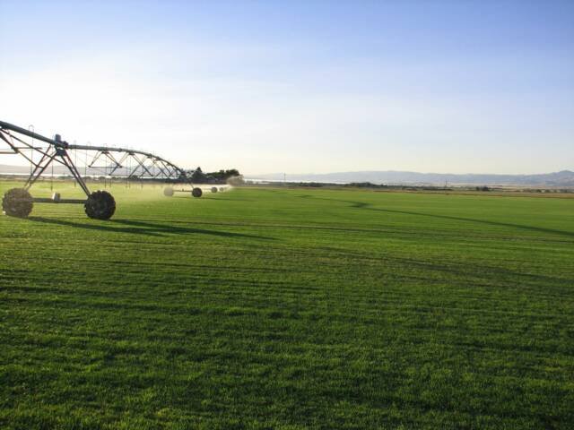
A picture named sodfarm.jpg

Here’s the release from Western Resource Advocates (Bart Miller), Trout Unlimited (Drew Peternell) and the Colorado Environmental Coalition (Beck Long):

Western Resource Advocates (WRA), Trout Unlimited (TU) and the Colorado Environmental Coalition (CEC) today released a plan that outlines how Colorado Front Range communities can meet projected human water demands through 2050 while keeping rivers healthy. In the new report, “Filling the Gap: Commonsense Solutions for Meeting Front Range Water Needs,” the conservation groups detail an approach that relies on low-impact water supply projects, conservation, water reuse, and agricultural-urban water cooperation to meet Colorado’s growing water demands.

Colorado is currently working through the Interbasin Compact Committee (IBCC) process to determine how the state’s river basins can meet their future water needs. The IBCC is considering a number of new storage projects, transbasin diversions, and moving of water over long distances. The “Filling the Gap” report offers an alternative plan showing how Front Range communities in the South Platte River Basin, home to some of Colorado’s largest municipalities including Denver, Boulder, and Fort Collins, can meet future needs without new major diversions of water from other river basins. The plan outlined in the “Filling the Gap” report is designed to be less expensive than traditional water supply approaches.

“Filling the Gap” identifies some water projects that the conservation groups could accept, if they were developed using a set of economically and environmentally- sound principals for minimizing the harm to streams and rivers. Some of these projects include the Chatfield Reservoir Reallocation, the Windy Gap Firming Project, Beebe Draw Aquifer Recharge, East Cherry Creek Valley’s Northern Project, as well expansion or enlargement of the Halligan Reservoir, Seaman Reservoir, and Gross Reservoir.

Coloradans are increasingly recognizing the critical importance of healthy flows to Colorado’s rivers and streams, which provide substantial economic and public benefits. For decades, many of these rivers and streams have been overtapped and pushed to the brink of collapse by multiple diversions.

“Many of Colorado’s rivers and streams are depleted to the point that they no longer support robust fisheries or recreational opportunities,” said Drew Peternell, director of TU’s Colorado Water Project. “Additional diversions from these streams could be devastating. ‘Filling the Gap’ charts a responsible path for meeting our water needs while protecting our state’s high quality of life.”

The report recommends that expanded conservation should play a key role in meeting future water demands. More than 50 percent of municipal water use is devoted to lawn watering, a use with low economic benefits when compared to other uses. By offering comprehensive incentives for consumers and industry to use water more efficiently, Front Range communities can achieve considerable water savings that can be used as new supply.

“This is low-hanging fruit,” said Drew Beckwith, the report’s primary author and WRA water policy manager. “Conservation is often the cheapest, fastest and smartest way to gain ‘new’ water supply.”

“Front Range communities are projected to double in size by 2050 so we must use water more wisely.” said Beckwith. “It is remarkable that increased water conservation and reuse efforts could nearly fill the gap between Front Range water supplies and growing demand.”

Agriculture, the largest sector of water use in the state, has been viewed as a target of water transfers to meet growing urban and municipal water needs. The report acknowledges that water sharing agreements can be beneficial to both sides, but “buy and dry” practices that permanently retire active farmland and reduce open space are the least desirable option. Instead, the report advocates voluntary and temporary market-based water transactions.

“By balancing competing uses and protecting rivers and streams, Colorado can sustain its growth and economy without harming its outdoors heritage and quality of life,” said Becky Long, Water Caucus Coordinator for the Colorado Environmental Coalition.

The “Filling the Gap” report provides a realistic and achievable blueprint for meeting the water demands of a population that is expected to double by the year 2050.

The report and supporting materials are available at http://www.westernresourceadvocates.org/gap

More coverage from Chris Woodka writing for The Pueblo Chieftain. From the article:

The groups presented their own version of a “four-legged stool,” mimicking the imagery the Interbasin Compact Committee chose in presenting its plan to Gov. John Hickenlooper in December. The report, “Filling the Gap: Common Sense Solutions to Meeting Front Range Water Needs,” omits using new supplies of water and reduces the number of acceptable projects in favor of adding heavier emphasis on urban conservation and reuse. It also stresses cooperative ventures between agricultural water rights holders and cities, and using energy-efficient, environmentally responsible projects. “Many of Colorado’s rivers and streams are depleted to the point that they no longer support robust fisheries or recreational opportunities,” said Drew Peternell, director of Trout Unlimited’s Colorado Water Project. “Additional diversions from these streams could be devastating. ‘Filling the Gap’ charts a responsible path for meeting our water needs while protecting our state’s high quality of life.”[…]

The report identified 575,000 acre-feet of potential water supply without building new pipelines or tunnels, which were labeled as “old ideas” by Bart Miller, water projects director for Western Resource Advocates…

While cities have resisted characterizing conservation savings as a source of future supply because they are not reliable during droughts, Miller said that Western cities, in practice, are using conservation savings as a way to stretch permanent water supplies…

Other than small expansion of a few transmountain projects, Filling the Gap stays away from transbasin solutions. Additionally, it puts emphasis on cooperative ways to share ag water that keep water rights tied to the land, Miller said. “We are very much proposing no more buy-and-dry, but instead looking at voluntary, short-term ways to share the water,” Miller said.

More coverage from the Summit County Citizens Voice (Bob Berwyn):

The report focuses on conservation, re-use and conversion of agricultural water as cost-effective alternatives to developing new pipelines and reservoirs. Colorado is currently working through the Interbasin Compact Committee process to determine how the state’s river basins can meet future water needs. The committee is considering a number of new storage projects, transbasin diversions, and moving of water over long distances. The “Filling the Gap” report shows how Front Range communities in the South Platte River Basin, home to some of Colorado’s largest municipalities including Denver, Boulder, and Fort Collins, can meet future needs without new major diversions of water from other river basins…

The report recommends that expanded conservation should play a key role in meeting future water demands. More than 50 percent of municipal water use is devoted to lawn watering, a use with low economic benefits when compared to other uses. By offering comprehensive incentives for consumers and industry to use water more efficiently, Front Range communities can achieve considerable water savings that can be used as new supply…

The report identifies some water projects that the conservation groups could accept if they were developed using a set of economically and environmentally- sound principals to minimiz the harm to streams and rivers. Some of these projects include the Chatfield Reservoir Reallocation, the Windy Gap Firming Project, Beebe Draw Aquifer Recharge, East Cherry Creek Valley’s Northern Project, as well expansion or enlargement of the Halligan Reservoir, Seaman Reservoir, and Gross Reservoir (the Moffat firming project). The key to making those projects acceptable is timing the diversions and releases to minimize impacts to aquatic life, Peternell said during a March 2 conference call…

“By balancing competing uses and protecting rivers and streams, Colorado can sustain its growth and economy without harming its outdoors heritage and quality of life,” said Becky Long, Water Caucus Coordinator for the Colorado Environmental Coalition.

More coverage from Janice Kurbjun writing for the Summit Daily News. From the article:

The report combats utility company planning efforts that lean toward dams, diversions, pumps, pipelines and other traditional measures to provide the much-needed water and instead suggests using technology and creativity to solve the water shortage problem…

Tourism accounts for vastly more state revenue than agriculture, said Becky Long of the Colorado Environmental Coalition. “It’s huge,” she said. “We need to make sure we have water for tourism.”[…]

But, is it possible to minimize impacts with these types of projects? “Yes and no,” [Jim Shaw of the non-advocacy Blue River Watershed Group] said. “Ecosystem development is based on natural flows. But, the natural variation is great enough that if we take water in high flow periods, impacts are far less than taking water from low-flow periods,” which can result in even lower flows and warmer stream temperatures. “You can do it better or worse, but you can’t do it perfectly,” he said.

Which seems to be the case with other measures, like cooperation between agriculture and urban water uses. The group proposes enhancing municipal supplies by granting financial benefit to the agriculture community through various measures such as water leasing. Shaw said reducing agriculture water consumption by 15 percent could create enough water to satisfy needs through 2050. “But with water law, that’s easier said than done,” he said, referring to the “use it or lose it” mentality that currently exists…

One main component of the approach is conservation — something both Front Range residents and mountain folk can be doing simultaneously, Long said. The report states that a 34 percent reduction in per-capita demand would result in a reduction of 362,000 acre-feet of water demand annually by 2050, some of which can be applied to new water demands.

More conservation coverage here.

Arkansas River basin: Woodmoor exchange case update

A picture named arkansasriverbasin.jpg

From The Pueblo Chieftain (Chris Woodka):

The exchange case was referred to Chief District Court Judge Dennis Maes on Monday, after the Pueblo Board of Water Works refused to settle the case in conferences with the water referee. The objections from the water board include the speculative nature of the exchange filing and concerns that water could be used outside the Arkansas River basin — Woodmoor, located in northern El Paso County, straddles the Palmer Divide.

Two other major El Paso County Water Court cases involving the transfer of water rights from the Upper Arkansas River basin are moving ahead as well.

A 2008 application seeking to change the use of water from the H2O Ranch in Custer County purchased for $3.5 million by Fountain and Widefield has been stayed pending the outcome of a 1996 Custer County water rights case that is being appealed to the state Supreme Court. Oral arguments in the case could either increase or decrease the yield of the water from the ranch, according to Curtis Mitchell, water conservation and supply manager for Fountain. The water rights were initially projected to yield 600 acre-feet of water or less annually, but that estimate was shelved until the other case is decided…

A 2009 application involves the change of water rights from the Mount Massive Ranch, purchased by the Donala Water and Sanitation District. While all but four of the 18 objectors in the Water Court case have settled, the Donala case is scheduled to move to trial Tuesday. Donala paid $4.7 million for the ranch and expects about 300 acre-feet annually from the water rights associated with the ranch. The district just north of Colorado Springs envisions a number of ways to use the water, including becoming a future partner in the Southern Delivery System.

More Arkansas River basin coverage here.

The Crystal Valley Environmental Protection Association is organizing opposition to Crystal River conditional storage rights

A picture named crystalriver.jpg

From the Glenwood Springs Post Independent (Janet Urquhart):

The Crystal Valley Environmental Protection Association (CVEPA) has asked both [Pitkin] county commissioners and the county’s Healthy Rivers and Streams Board to oppose the conditional water rights. The Crystal River Caucus has joined in that call, according to Redstone resident Bill Jochems, a member of both the CVEPA board and the county rivers and streams board…

The Glenwood-based Colorado River Water Conservation District holds the conditional water rights on behalf of the West Divide Water Conservancy District. The rights, decreed in the 1950s, are the basis for two proposed water storage projects on the Crystal that were authorized by Congress in the mid-1960s but never built. The West Divide Project water rights must be reauthorized in Colorado Water Court every six years. In May, the holders of the water rights must show diligence, or continued progress on the project, in order to keep the water rights alive. The Crystal River groups have asked the county to challenge the validity of the rights. “Nothing has been done on the ground for 54 years,” said Jochems. Progress has been limited to studying the options, he added…

The conditional water rights allow for the proposed Osgood Reservoir, which would impound nearly 129,000 acre feet of water, flooding the town of Redstone, Redstone Castle and several subdivisions, CVEPA said. Also envisioned is the Placita Reservoir south of Redstone, which would impound about 62,000 acre feet of water. For the sake of comparison, Ruedi Reservoir on the Fryingpan River, east of Basalt, holds 140,000 acre feet of water, CVEPA noted in its letter to county officials. “We do not think anyone takes these proposed reservoirs seriously, yet they threaten to deny designation of the Crystal River as a Wild and Scenic River and cost the taxpayers money as they continue to be defended,” the letter states.

With no dams or significant diversions on the Crystal currently, advocates would like to see it further protected by the federal Wild and Scenic River designation. The upper Crystal River Valley is nestled between the Raggeds and Maroon Bells-Snowmass Wilderness areas to the east of Marble. The Crystal River flows into the Roaring Fork River at Carbondale.

More Crystal River watershed coverage here and here.

RIP Dick MacRavey

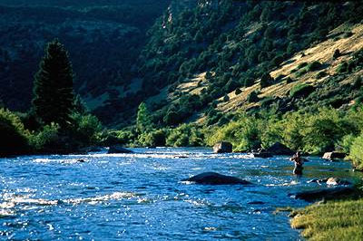
Dolores River

Here’s the release from the Colorado Water Congress (Doug Kemper).

Richard D. MacRavey
Executive Director Emeritus
Colorado Water Congress
1931 – 2011

Dick MacRavey passed away this morning at about 5:00 am. Over the past few days, he was fighting an infection and fever. His oxygen level dropped significantly. He died peacefully.

Dick was the Executive Director of the Colorado Water Congress from 1980 until 2006. He will be remembered for his tireless work in rescuing the Colorado Water Congress from financial difficulty. He built a legislative record that will stand as a permanent tribute to a man whose vision shall endure. Without his leadership, there would be no Colorado Water Congress today.

A memorial service to celebrate Dick’s life is being planned for the latter part of March in Castle Rock. More details will be released as they become available.

“This is truly a sad day for Mary, the MacRavey family and friends, and the entire water community. Dick will always be remembered as the face of Water Congress for so many years. He will be greatly missed by all.” Joe Frank, Colorado Water Congress President

“. . . his is a life worth celebrating with many great and wonderful stories. I am certain Chips, John Sayre, and MacRavey are already in some heated argument over the doctrine of prior appropriation!” Sam Mamet, Colorado Municipal League Executive Director

“It is certainly a sad day for the water community. Dick was dedicated to us and to our interests. May he rest in peace.” David Robbins, Colorado Water Congress Former President

More coverage from Chris Woodka writing for The Pueblo Chieftain. From the article:

Richard D. “Dick” MacRavey, who had a knack for herding the state’s water buffaloes in basically the same direction, died Monday. MacRavey, who would have been 80 on Wednesday and lived in Denver, was the executive director of Colorado Water Congress from 1980-2006, and helped that group shape state water policy in many ways.

When MacRavey retired in 2006, then-Sen. Ken Salazar noted: “Dick MacRavey is retiring from the Colorado Water Congress at a moment when the outlook for consensual politics in the West is strong. This is no coincidence. Dick has championed an approach to water that calms our quarrels by highlighting our shared interests.”

More coverage from Kyle Glazier writing for The Denver Post. From the article:

A man who colleagues say worked tirelessly to save the Colorado Water Congress from financial difficulty and protect Colorado’s water resources died this morning after several days of illness, the Water Congress said. Richard MacRavey died after battling fever and infection, said a Water Congress news release. MacRavey served as executive director of the water-rights advocacy group from 1980 to 2006. He was 79.

Pueblo: Arkansas River levee repairs update

A picture named puebloleveearkansasriver.jpg

From The Pueblo Chieftain (Britney Whatley):

Water has to be moved away from the levee through the Downtown Whitewater Park. Using the HARP channel to carry more water is one way to meet that goal. The water on the main Arkansas River channel needs to be low enough for equipment to be lowered into the water to repair the levee before water levels begin to increase later this month, said Gus Sandstrom, president of the Pueblo Conservancy District…

The project began in early February. Sandstrom said repairs should be finished by March 15 at the earliest and April 1 at the latest. “Our goal is to be completed enough to not endanger the accreditation of the levees,” Sandstrom said. The goal is to complete as much of the repairs as possible, depending on the type of moisture that occurs through March.

More Arkansas River basin coverage here.

South Platte River basin: Basin roundtable non-consumptive needs report

A picture named southplattebasinnonconsumptiveneedsmapswsi2010

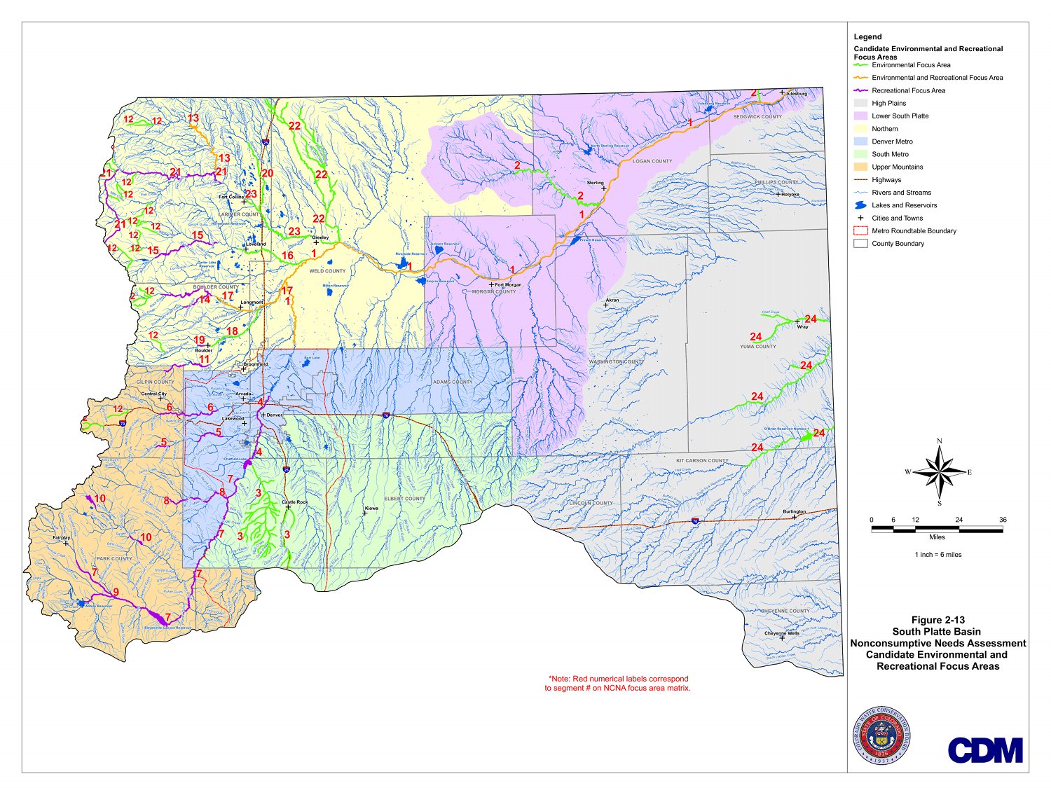
As part of the roundtable process the various basin roundtables are working on the non-consumptive needs (recreation, wildlife, riparian environment). Click here for the CWCB web page for the 2010 SWSI Update and the supporting docs. Click on the thumbnail graphic to the right for the South Platte basin map.

Thanks to Eric Hecox for pointing out the docs.

More IBCC — basin roundtables coverage here.