Energy policy — hydroelectric: Local landowners around the proposed South Slope project upper reservoir are assessing impacts

A picture named pumpedstoragehydroelectricschematic.jpg

From The Colorado Springs Gazette (R. Scott Rappold):

Colorado Springs developers Jim and Mark Morley want to build a pumped hydroelectric storage plant here, in which water is pumped uphill to a reservoir when demand is low and released downhill to power turbines when demand is high or other parts of a system, such as solar or wind, are not generating much power. It has the support of lawmakers, who passed a bill [HB 11-1083] to encourage such projects, signed by the governor last month; energy giant TransCanada, which may be interested in building and running the plant; and some in Penrose, who say the 300 temporary and 30 permanent jobs will be a boost to the economy. Said Collins, “Are we fighting a losing battle up here? Probably. But for the tenacious, no road is impossible.”[…]

Residents in the Red Rocks at Beaver Creek subdivision, 25 homes on 72 lots above the Morleys’ property, say they knew nothing about the bill or the project. They only recently launched a website, www.thesouthslope.com, to voice their opposition. They worry about noise from turbines and pumps, extra truck traffic, ground vibrations from the equipment, impacts to the view, and declining property values. They worry eminent domain could be used to seize land. And some have a larger critique of the project: that it isn’t renewable energy at all.

The water, 13,000 acre-feet, or 4.2 billion gallons, a one-time purchase from a still-unidentified water-rights holder, would be piped from the Arkansas River, and then reused over and over again. But it would take power, equal to about 20 percent of what the plant generates, to pump the water uphill, which would come from elsewhere in the power grid. Opponents say that means it should not be considered “renewable.”

“What we’re trying to do is uncover the truth about the South Slope project,” said resident Robert “Hutch” Hutchison.

“Everybody’s going to be in favor of a hydroelectric plant that is renewable and green, but that’s not what this is,” said Collins.

More hydroelectric coverage here and here.

Colorado Springs Utilities brings ultraviolet disinfection system online

A picture named uvdisinfection.jpg

From NewsFirst5.com (Bill Folsom):

Intense UV light is applied at the end of the treatment process; killing bacteria in the waste water. It is safer and more eco-friendly because it decreases the use of gas and chemicals for treatment. “Having that much chemical stored down here is a risk,” says Manager, Jed Chambers, “it was hard to handle with our employees and then bottom-line and most importantly the environmental aspect.”

More wastewater coverage here and here.

Colorado Division of Wildlife: Commissioners begin water plan reviews

A picture named grossreservoir.jpg

From the Summit Daily News:

On Thursday, the Colorado Wildlife Commission received fish and wildlife mitigation plans from Denver Water and the Northern Colorado Water Conservancy District that describe the water providers’ proposals for addressing expected impacts from two transmountain diversion projects that would provide more reliable water supplies to the Front Range…

The May meeting in Salida should allow additional time for the public to comment and provide input on the two plans as well as two voluntary enhancement plans also being submitted by the water providers. That’s in addition to numerous public and stakeholder meetings since October…

When the Wildlife Commission submits its recommendation to the Colorado Water Conservation Board, the board will then have 60 days to affirm the Commission’s recommendation as the official state position or modify the recommendation. If the board makes revisions, the governor will have 60 days to affirm or further modify the recommendation, which then becomes the official state position with regard to mitigation.

More Moffat Collection System Project coverage here and here.

More Windy Gap coverage here and here.

Irrigation return flows sustain the wetlands around John Martin Reservoir according to Arkansas Basin Roundtable report

A picture named playalake.jpg

From The Pueblo Chieftain (Chris Woodka):

“The irrigation returns nearly match the wetlands evapotranspiration, so it’s a good indication of why the wetlands are there,” said Hal Simpson, a former state engineer who works for CDM engineering. The roundtable is looking at wetlands near John Martin Reservoir and at Nee Noshe, in Kiowa County, as part of its effort to identify nonconsumptive water needs in the Arkansas River basin.

Nee Noshe is a different situation. It’s significant among the numerous shallow lakes on the Eastern Plains because threatened species like the piping plover and least tern live there, said SeEtta Moss, of the Arkansas Valley Audubon Society. Nee Noshe has shrunk over the past 10 years to about one-fifth of its dead pool — the point where water can no longer flow out — and is evaporating. It would take about 1,000 acre-feet annually to sustain it, but the water is not available through the Amity Canal.

Simpson said the wetlands at John Martin developed before the reservoir started filling after 1948. “They were not dry and existed independent of John Martin Reservoir,” Simpson said, explaining that wildlife habitat expanded in the valley after irrigation began.

More IBCC — basin roundtables coverage here.

Snowpack/precipitation/runoff news: A beautiful rain/snow for the northern Colorado plains

A picture named precipitationcocorahs04142011

From The Denver Post (Kieran Nicholson):

More than a foot of snow fell in some parts of the mountains and areas in the foothills received several inches of snow as well, said David Barjenbruch, a meteorologist and spokesman with the National Weather Service in Boulder. “The north got lots of great water equivalent that will help minimize fire dangers, at least over the next several days,” Barjenbruch said…

Aspen Springs, in Gilpin County, received 19 inches of snow and areas around Nederland, in Boulder County, received up to 16 inches of snow. Closer to Denver, the Evergreen and Conifer areas, in Jefferson County, received between 4 to 6 inches of snow and Boulder got about 2.5 inches.

From The Telluride Watch (Gus Jarvis):

According to the most recent snowpack percentages provided by the Natural Resources Conservation Service, the San Miguel, Dolores, Animas and San Juan watersheds, as a group, are currently at 88 percent of average, while the Upper Rio Grande is at 79 percent. And these two watershed groups are the only two in Colorado reporting average levels of below 100 percent. Statewide the snowpack level is 114 percent of average, with the highest snowpack levels found in the Yampa/White (133 percent of average) and North Platte (138 percent of average) watersheds in northwestern Colorado…

For rivers relying on reservoir storage, Lang said, the data corresponds (to snowpack averages), with reservoir levels statewide at 103 percent of average, and the San Miguel, Dolores and Animas watershed reservoir storage average coming in at 82 percent.

For boaters seeking a trip on the Dolores River below McPhee Reservoir, indications are there will be a release sometime in May, but precisely when is unclear. According to an updated press release issued on April 12 by the Dolores Water Conservation District, the release of 800 Cubic Feet per Second (CFS) intended for Memorial Day weekend is now expected to come May 20.

From The Crested Butte News (Alissa Johnson):

…the Gunnison Basin’s snowpack sits at 115 percent of average, according to Natural Resources Conservation Services (NRCS) snow survey supervisor Mike Gillespie. Snowpack has been declining each month since January, when it sat at 158 percent of average…

“We’re forecasting above-average runoff across the northern part of Gunnison Basin, and that is a favorable condition for all water users. Water rights will be met, people won’t be curtailed from receiving water rights, that kind of thing,” Gillespie said. The same north to south transition visible across the state is mirrored in Gunnison Basin. The inflow into Paonia Reservoir is at 131 percent of average, and to the south, Uncompahgre is at 94 percent. Blue Mesa sits right in the middle, at 111 percent of average.

From Steamboat Today (Joel Reichenberger):

The Yampa River has slipped above 700 cubic feet per second twice in the last week, and Wednesday afternoon it was pushing above 650. That’s higher than the April 13 average for the last 100 years by more than 100 cfs, but still less than one-third of what the river runs at in late May and early June. “All the preliminary indicators are that it’s going to be a good season,” said Pete Van De Carr, owner of Backdoor Sports in Steamboat. “We’re psyched.”

From the Longmont Times-Call:

Total rain/snow precipitation amounted to 1 inch…Times-Call weather consultant Dave Larison said the storm brought the most single-storm precipitation since 1.53 inches fell from heavy rains on Jun. 11-13, 2010. Longmont’s year-to-date precipitation is now up to 2.35 inches, still about a half inch below normal to date.

The Bar N-I Ranch Community Service Foundation, Culebra Range Community Coalition, and Purgatoire Valley Foundation are combining resources for a water festival in conjunction with ‘Water 2012’

A picture named spanishpeaks.jpg

From The Trinidad Times (Steve Block):

A water festival would be an outdoor activity for the people of this area and could also attract visitors traveling to the area for their summer vacation, according to organizers of the potential event. The Bar N-I Ranch Community Service Foundation, Culebra Range Community Coalition, and Purgatoire Valley Foundation are combining resources and looking for public support of the water festival idea. The Culebra Range Community Coalition is taking the lead in making plans for the event. Its president, Tom Perry, can be reached at 846-8380…

A Watershed Group Committee is being formed and is working on getting the word out about Water 2012.

More Colorado Foundation for Water Education coverage here.

Boulder: Boulder Wastewater Treatment Facility employs cogeneration to reduce power costs

A picture named wastewatertreatmentprocess.jpg

From the Boulder Weekly (Chelsea Long):

…since 1986, the treatment facility has been finding ways to offset that electrical necessity. Back then, it was methane gas. Now, it’s solar power. “For the last 25 years, we’ve been beneficially using the methane gas that we derive from treated solids. As we break down and treat solids, a gas is formed that’s primarily methane,” Douville says. “Methane has a combustion value, and we use a system called co-generation to make electricity.” That system generates an average of 20 percent of the facility’s power needs, and it keeps methane from being released in the atmosphere. “Not all communities do that. We’re on the exception end of things,” Douville says. “Normally what a facility would do is burn the gas, so they’d flare it, ignite it and combust it, and it would go off in the atmosphere as carbon dioxide and heat. Boulder made the commitment to produce electricity.”[…]

One of the last steps in decontamination is to rid the water of bacteria and other pathogens that are present in high levels. Currently, the center uses gaseous chlorine to disinfect the water of these pathogens. “It’s very effective but is extremely toxic to aquatic life and a huge safety risk to city staff and residents nearby, if we had a leak or tank rupture. That’s a low-probability event, but still a realistic risk scenario that we face,” Douville says. The center uses a second gas to dechlorinate and remove residual chlorine, so that toxins aren’t released into the stream, but both of those gases will be replaced with a UV disinfection system. “It’s a focused, targeted wavelength of high energy that only takes a matter of seconds to disinfect the wastewater and achieve compliance with our regulations,” Douville says.

More wastewater coverage here and here.

The Cherokee Metropolitan District is suing their former attorneys

A picture named waterfromtap.jpg

From KKTV.com (Karen Morfit):

The suit alleges the attorneys were profiting at the expense of the water district and its customers. Those former attorneys, James Felt and James Culichia deny the allegations. The lawsuit also includes Felt and Culichia’s law firm, Felt, Monson and Culichia. We’re told the case is still in the early stages and documents are still being investigated.

Among the allegations are that one of the attorneys represented a private client, who later sold water rights to Cherokee for hundreds of thousands of dollars, an apparent conflict of interest. Even the district’s current attorney, Kevin Donovan, says the conflict was presented to the boards’ former manager. “Because there was so much involved, and so much money involved in it. That at least it’s Cherokee’s position now, that unless other evidence comes up that was an un-waiveable conflict,” Donovan said.

More Cherokee Metropolitan District coverage here and here.

Florence: Public meeting to discuss possible water rate increases May 2

A picture named fountainpavementdrawing.jpg

From The Pueblo Chieftain (Tracy Harmon):

With revenue down and costs going up, the water fund started showing signs of a deficit last September, said Dori Williams, Florence city clerk. “City Council is talking about a water rate increase,” Williams said. Council has scheduled a public meeting at 6 p.m. May 2 in the council chambers (600 W. Third St.). “We could do a staged increase because we don’t want a real high rate increase. We don’t want it to go so high people stop watering their lawns and trees and we price ourselves out of a nice-looking city,” Williams said.

More infrastructure coverage here.

Snowpack/runoff news: Eagle County Emergency Management is getting the news out about potential flooding

A picture named fortcollinsflood07281997

From the Vail Daily (Lauren Glendenning):

“It’s never a matter of how much snowpack we’ve got, it’s how fast it melts,” said Barry Smith, with Eagle County Emergency Management. Smith sent out an Eagle County Alert Tuesday that contained information about flooding — everything from the definitions of flash floods, flood watches and flood warnings, to tips for local citizens on how to remain safe during floods…

Snowpack is about a 110 to 115 percent of normal right now. If the snowpack starts exceeding 130 percent, Smith said it might be time for the county and local agencies to start stocking up on more sand bags. “Right now, I’m not real concerned about (local preparedness),” Smith said. “I think we’re adequately prepared for what’s coming our way, but if we start seeing forecasts with two weeks of temperatures in the 70s, that’ll obviously change.”[…]

The floods in Vail last summer exceeded 100-year flows, according to the Federal Emergency Management Agency. There were 58 locations in the town of Vail alone that experienced floods, with improvements to the damaged areas expected to cost anywhere from $1.5 million to $3 million, according to a 2010 Gore Creek flood assessment report…

Sean Glackin, owner of Alpine Quest Sports in Edwards, said people are already running the [Colorado River] down by Glenwood Springs and in western Colorado toward the Utah border.

From the Summit County Citizens Voice (Bob Berwyn):

Dillon Reservoir is likely to fill sometime in June regardless of spring weather, said Bob Peters, a resource engineer with Denver Water.

Lake Powell news: 2011 water year inflows forecasted to be 106 percent of average, about 12.78 million acre feet

A picture named lowlakepowell2004

Lake Powell (actually a reservoir at Glen Canyon) shows up on the original maps Delph Carpenter used as technical support for the movers and shakers that negotiated the Colorado River Compact. He saw the reservoir as key to enabling the upper basin states to meet compact requirements for deliveries to the lower basin states at Lee’s Ferry. The reservoir has served the compact well in that role. The upper basin states have never failed to deliver the 10 year moving average of 75 million acre-feet required by the “Law of the River.”

Here’s an in-depth look at the recent hydrological history of the upper basin and how Lake Powell has fared with a look ahead for this water year, from Bob Berwyn writing for the Summit County Citizen’s Voice. From the article:

As recently as 1999, Lake Powell was full, storing 23.5 million acre-feet of water — about 97 percent of capacity. During the next five years, 2000 – 2004, inflow into Lake Powell was well below average and storage dropped to about 8 million acre-feet, about 33 percent of capacity. Drought conditions eased somewhat in 2005, 2008 and 2009, bringing storage back up to about 12.9 million acre-feet (53.1 percent of capacity) as of March 7, 2011. For perspective, that’s still about 88 feet below full pool…

Based on current snowpack readings and runoff predictions, the Bureau of Reclamation expects March inflow to be about 90 percent of average, climbing to 112 percent of average in April and 126 percent of average during the peak runoff month of May. For the 2011 water year, the expectations are that inflow will total about 106 percent of average, about 12.78 million acre feet.

More coverage from The New York Times (Felicity Barringer). From the article:

the Interior Department announced this week that it would follow its original plan and deliver 40 percent more water than usual from Lake Powell, the Utah reservoir that is 357 miles upstream and about 2,500 feet uphill from Lake Mead. With users in Los Angeles, Las Vegas and the agricultural valleys of California and Arizona expected to take a little less than normal for 2011, most of the excess of more than three million acre-feet will stay in Lake Mead, the lower of the two massive Colorado River reservoirs that have enabled the rapid growth of Phoenix, Las Vegas and southern California.

Here’s a guest commentary about the Colorado River basin written by Lori Weigel and Andrew Maxfield that is running in The Denver Post. From the article:

As Democratic and Republican pollsters, we can speak to the fact that the West is politically divided on many issues, but water isn’t one of them. Voters of all political stripes have witnessed the rapid growth in states like Colorado, Arizona and Nevada, where urban populations have grown by 20 percent to 30 percent over the last decade. They know demand has increased.

On the supply side, Republicans and Democrats may disagree somewhat on the reasons why there is less water, but at a certain point, it doesn’t matter whether the reduced water flows are due to higher temperatures from climate change or the result of a 12-year drought. It is simply a harsh reality everyone faces.

The effects have been felt by some in the West more than others, but most everyone recognizes that future water shortages will affect everyone. Farmers and ranchers have been dealing in a high-stakes game with cities over water rights, affecting our food supply and city budgets. Outfitters, hunters, fishermen and recreationists such as paddlers can speak to the already profound effects that reduced water flows are having on lakes, rivers and wildlife in the West’s great outdoors — risking the environment and outdoor recreation-dependent economies. People are beginning to experience the effects of less water in their own households…

In the Harstad Research polling, voters almost unanimously said we need to find a way to balance the water we have — between personal and residential water needs, the water needed to preserve the rivers, lakes and forests of our national parks, and the agricultural water needs of our farms and ranches — even if it means that everyone must find ways to conserve. Interior Secretary Ken Salazar told the recent meeting of the Colorado River Water Users Association, “We must build a water policy that is inclusive of all interests.” Well, voters would tend to agree. There are plenty of political fights ahead in the West, but figuring out what to do about water shouldn’t be one of them.

More Colorado River basin coverage here.

Report: ‘Agricultural/ Urban/Environmental Water Sharing: Innovative Strategies for the Colorado River Basin and the West’ to be presented today to the Western States Water Council meeting in Sante Fe

A picture named sanluispeoplesditch.jpg

Sante Fe was the location for the signing of the Colorado River Compact which set aside prior appropriation on the Colorado River with an agreement to share streamflow between the upper and lower Colorado River Basin states. Hopefully, the location will beneficial to drive alternative strategies to the dry up of agricultural lands to water people and bluegrass. Here’s a report from Bobby Magill writing for the Fort Collins Coloradoan. From the article:

The report suggests that water sharing between agricultural producers, cities and environmental interests may be one of the keys to meeting future water supply requirements while also helping to maintain wildlife habitat in some areas, said MaryLou Smith of CSU’s Colorado Water Institute, which wrote the report. The report, “Agricultural/ Urban/Environmental Water Sharing: Innovative Strategies for the Colorado River Basin and the West,” will be presented to the Western States Water Council, part of the WGA, today in Santa Fe, N.M. The hope is that governors in all 11 western states will add to their Cabinets a water expert who will focus on ways each state’s water interests can come together and solve water supply problems through sharing.

Water sharing, Smith said, would allow farmers to share some of their water with conservationists or cities, keeping farms active while providing for water to be kept in streams for wildlife or sent to cities for drinking water. It’s an alternative to agricultural water transfers, which would require farmers to fallow their land and possibly go out of business in order for their water to be used in growing cities or for wildlife conservation.

The Arkansas River Roundtable approves a study of water law and new water sharing strategies

A picture named arkbasinditchsystem.jpg

From The Pueblo Chieftain (Chris Woodka):

The study would help projects like the Arkansas Valley Super Ditch, or any effort that would allow farmers to retain water rights yet lease water, to determine what limitations could work against the concept, and what laws might help implementation. The study would then be discussed in a facilitated dialogue to air concerns in public…

The $20,000 study would be administered by the Pikes Peak Regional Water Authority, which [Gary Barber, chairman of the roundtable] manages, and would be jointly funded by four separate roundtables, in hopes of avoiding the pitfalls of a failed bill that raised numerous objections. The study of laws would be done by Sand Dollar Research, a firm headed by policy analyst Dick Brown. Heather Bergman, of Peak Facilitation and the facilitator for the Fountain Creek Vision Task Force, would referee community discussion about the findings…

Reeves Brown, a Beulah rancher who sits on the Lower Arkansas Valley Water Conservancy District board that has supported Super Ditch, said the valley needs to find ways to make better use of water. “There’s extra water that could be put to use every year,” Brown said.

Some were nervous about the implications of changing water law. “You really risk a lot. What’s to prevent expansion of use?” asked Terry Scanga, manager of the Upper Arkansas Water Conservancy District. “It’s important to find out where we are now.”

More IBCC — basin roundtables coverage here.

Denver Water is embarking on an 18 month project to install a new water tank in Lone Tree

A picture named orrmnwatertower.jpg

From the Lone Tree Voice (Chris Michlewicz):

Denver Water will begin building a 10 million-gallon water tank on Chaparral Road this June or July. In a letter sent to nearby homeowners, Denver Water said the additional tank is “critical to provide a reliable potable water supply and meet fire demands in the area.” The improvement is also part of a rehabilitation program for the aging system, which would be prone to outages without upgrades. The $10 million project will put a storage tank within feet of an existing water tank just north of Eagle Ridge Elementary School.

More infrastructure coverage here.

Energy policy — oil and gas: FracFocus.org contains information on chemical composition of hydraulic fracturing fluids

A picture named derrick.jpg

From the Glenwood Springs Post Indpendent (John Colson):

“Hydraulic fracturing in Western Colorado has resulted in ongoing concern and reasonable questions from local communities,” said David Ludlam, executive director of the Western Slope Colorado Oil and Gas Association in Grand Junction. “This tool will go a long way to help ease those concerns and clear up some misunderstandings about hydraulic fracturing technology,” he said…

The website is underwritten by the Ground Water Protection Council, a national nonprofit group, and the Interstate Oil and Gas Compact Commission, an industry advocacy organization. “This voluntary ‘disclosure’ site allows authorized members of the oil and natural gas industry to upload chemical information for hydraulic fracturing jobs conducted after January 20, 2011,” according to the website.

As of April 11, the only participant in Garfield County was Williams Petroleum, which listed 10 hydraulic fracturing procedures conducted between Feb. 2 and March 12.

More oil and gas coverage here and here.

Snowpack news: Has the snowpack peaked?

A picture named swehilostate04132011

From The Denver Post (Scott Willoughby):

According to the April 1 survey from the USDA Natural Resources Conservation Service (NRCS), the statewide snowpack total was 113 percent of average and nearly 30 percent higher than a year ago. Multiple mountain storms since that date have bolstered the figures, which should translate to healthy river flows. But there’s no telling how the water will come down the mountain. A warm, dry spell typically means short, rapid runoff, while lingering cold and precipitation could extend the melt into summer. Already several Western Slope waterways have started showing signs of life, and increasing turbidity as a result…

River basins in the northern mountains, including the Colorado, Yampa, White and South Platte rivers, are looking at the deepest snowpack since 1996. Currently at 138 percent of average, the North Platte River Basin had the highest basinwide total in the state and the highest for April 1 since basinwide totals began to be calculated in 1968…

Meanwhile, the April 1 readings showed snowpack conditions across the southern mountains decline for three consecutive months, placing the Rio Grande and combined San Juan, Animas, Dolores and San Miguel basins well below average. A late boost of snowfall last week bumped the graph up to 79 percent of average in the Rio Grande basin two days after its April 10 average peak, while snowpack in the combined San Juan, Animas, Dolores and San Miguel basins climbed to 88 percent of average. Some smaller tributary basins in the Rio Grande basin have dropped to nearly 50 percent of average.

NIDIS Weekly Climate, Water and Drought Assessment Summary of the Upper Colorado River Basin

A picture named wycoutprecipitationapril3to92011

Here are the notes from yesterday’s webinar from the Colorado Climate Center.

More Colorado River basin coverage here.

Aspinall Unit operations update: Flows through the Gunnison Tunnel to increase to 750cfs today, operations meeting April 21

A picture named gunnisontunnelnps.jpg

From email from Reclamation (Dan Crabtree):

The Uncompahgre Valley Water Users will be increasing diversions through the Gunnison Tunnel this afternoon, bringing Tunnel diversions up to about 750 cfs. This will result in Black Canyon and Gunnison Gorge flows of about 1,250 cfs.

Please note, Reclamation will be holding the April Aspinall Operations meeting on April 21st starting at 1:00 p.m. in the Grand Junction Western Colorado Area Office located at 2764 Compass Drive Suite 106. We will be discussing past operations and the upcoming spring runoff operations. Everyone is welcome to attend.

More Aspinall Unit coverage here.

Energy policy — nuclear: Trace amounts of fallout from the Japanese nuclear disaster found in Denver drinking water

A picture named nuclearpowerplantdiagram.jpg

From The Denver Post (Bruce Finley):

The radioactive isotope iodine-131 was detected at 0.17 picocuries per liter in Denver on March 30. EPA officials posted the results late Friday. The EPA has not set a specific drinking water contaminant standard for iodine-131. However, iodine-131 is a beta emitter, and the EPA has set a limit for total beta emitters equivalent to 3 picocuries per liter of iodine-131. “We understand that people get concerned when we talk about radiation, but it’s important to understand how these low levels compare to the radiation we experience from natural sources every day,” EPA spokesman Rich Mylott said in a prepared e-mail statement.

“To put this drinking water sample into context, an infant would have to drink nearly 7,000 liters of this water to receive a radiation dose equal to just one day’s worth of natural background exposure. That’s exposure we all experience every day from natural sources, such as the sun and rocks and gases in the earth’s crust.”

More nuclear coverage here and here.

Denver Water releases their Moffat Collection System mitigation plan

A picture named grossdam.jpg

From the Boulder Daily Camera (Laura Snider):

…the “Fish and Wildlife Mitigation Plan” released last week by Denver Water, which says the Gross Reservoir expansion is necessary to meet a projected shortfall of 18,000 acre-feet of water per year for its customers by 2030. The water to fill the newly expanded reservoir would be drawn from the Fraser and Williams Fork rivers — both tributaries of the Colorado River — and pumped across the Continental Divide to Boulder County via the Moffat Tunnel. The Colorado Wildlife Commission now has 60 days to review the mitigation plan, which addresses impacts on both sides of the divide, before providing a recommendation to the Colorado Water Conservation Board.

In Boulder County, the mitigation plan also calls for monitoring the stability of South Boulder Creek’s stream channel above Gross Reservoir, which would carry an increased amount of water if the expansion is approved. Denver Water would also add an extra 5,000 acre-feet of water to the reservoir that could be released in the winter to increase flows in South Boulder Creek below the dam.

The mitigation plan for the Gross Reservoir expansion was released at the same time as a mitigation plan for the Windy Gap Firming Project, which also seeks to bring more water to the Front Range from the Colorado River watershed. The Windy Gap project, which is being proposed by the Northern Colorado Water Conservancy District, would bring more water to some Boulder County towns, including Erie, Superior, Lafayette, Longmont and Superior…

Managers for the two projects also worked together to create an “enhancement plan” for the upper Colorado River tributaries that would address some of the ecological issues caused by low water flow in the area. Enhancements could include narrowing and deepening the river channel in some areas…

“The heavy focus on what they call enhancements — they are fine and good — but they really address past problems,” [Drew Peternell, director of Trout Unlimited’s Colorado Water Project] said. “What does this mean about these new projects?” Peternell said he also worries that the plan lacks teeth and clear thresholds for enforcement. For example, Trout Unlimited would like assurances that Denver Water will stop withdrawing water from the upper Colorado River if stream temperatures get too high, endangering fish. And they’re also concerned that spring “flushing flows” — which are ecologically important to the river — won’t be preserved.

Here’s the link to the Colorado Division of Wildlife website for the projects.

More Moffat Collection System Project coverage here and here. More Windy Gap coverage here and here.

Southern Delivery System update: The Colorado Springs city council green-lights condemnation for property owners that won’t settle

A picture named pipeline.jpg

From The Colorado Springs Gazette (Dave Phillips):

The council voted 7-1 to grant the utility power to acquire four property easements in Pueblo West that are standing in the way of a nearly seven-mile stretch of pipeline scheduled for construction this summer. Councilman Tom Gallagher, a longtime SDS critic, cast the lone dissenting vote. “This is an unfortunate necessity,” said Councilman Sean Paige. “We never want to take this step if we can avoid it.” Utilities has been negotiating with 170 landowners in Pueblo County for permission to bury a 66-inch pipe since September 2009, according to Keith Riley, the head of planning and permitting for the project. So far, 120 land owners in Pueblo County gave permission in exchange for payments roughly equivalent to 90 percent the appraised value of the land. Another 12 properties had liens or judgements against them, so Utilities had to use eminent domain to clear the land titles. Another 12 property owners remain unwilling to accept Utilities’ offers, although negotiations continue. “I’m hopeful we will still reach agreement, but based on how it is going, it does not look like that will occur,” Riley told Council.

More Southern Delivery System coverage here and here.

Drought news: On the southeastern Colorado plains the grass is not greening up due to little or no soil moisture

A picture named usdroughtmonitor04052011

From The Pueblo Chieftain (Anthony Mestas):

“A lot of farmers who are working the ground are finding that there’s no surface moisture, no submoisture and the (Arkansas) river is not coming up. The river is just low enough to keep a lot of ditches that normally should be running water right now out of priority,” [Chuck Hanagan, county executive director for the Farm Service Agency in Otero and Crowley counties] said…

“It’s been hot, it’s been dry and the wind is blowing. That puts everybody on edge,” he said.

Colorado-Big Thompson Project update: West slope operations meeting April 13

A picture named coloradorivergranby.jpg

From email from Reclamation (Kara Lamb):

Just a quick reminder that we and Northern Water will be hosting a West Slope C-BT operations meeting tomorrow night, April 13, at the Granby Library starting at 6 p.m. A flyer for the meeting is attached. We want to provide folks a heads up on what we are anticipating we will see through Shadow Mountain, Granby and Willow Creek reservoirs this run-off season.

More Colorado-Big Thompson coverage here.

Lincoln Park/Cotter Mill superfund site update: Trichloroethene is spreading in the groundwater around the site

A picture named cottercontamination.jpg

From KRDO.com (Joe Dominguez):

It was reportedly found in tests taken at the Shadow Hills Golf Course late last year but just reported to Colorado’s Department of Public Health and Environment. Cotter had been negotiating for the past few years with state health department officials on how to deal with contaminated ground water. That contamination was uranium found decades earlier. Some residents believe it’s time for someone else to take over…

“I think it’s going to take the federal government because it’s such a big mess,” said [Ethan McClaugherty]…

The main argument between the state and Cotter leaders that has slowed down the plan is how to deal with cleaning up contamination. Cotter wants to use a slower less expensive method while RAP leaders suggest cycling that contaminated water through pumps and machines and putting it back into the ground. This new development could delay those negotiations again. Cotter will now have to do more tests on ground water to determine how widespread the TCE problem is and where it is originating from. No timetable has been set for how long Cotter has to get those answers for the state.

More Lincoln Park/Cotter Mill superfund site coverage here.

Lake Mead news: Reclamation set to release 11.56 million acre-feet from Lake Powell

A picture named coloradoriverhooverdam.jpg

From the Las Vegas Review-Journal (Henry Brean):

The U.S. Bureau of Reclamation has announced plans to release extra water from Lake Powell between now and September under federal guidelines that direct the “equalization” of the nation’s two largest man-made reservoirs. Lake Powell is required to send a minimum of 8.23 million acre-feet of water downstream to Mead each year. On Friday, bureau officials set this year’s release at 11.56 million acre-feet, more than enough to stave off an unprecedented shortage declaration that would require Nevada and Arizona to cut their river use.

Pat Mulroy, general manager of the Southern Nevada Water Authority, said it’s nice to have some good news for a change. “I’m delighted, absolutely delighted. We’re not going to lose any ground this year,” she said…

The extra 3.3 million acre-feet Lake Mead soon will receive is roughly 14 times the amount of Colorado River water used valleywide [Las Vegas and environs] last year.

Colorado Division of Wildlife: Commissioners begin water plan reviews

A picture named coloradotransmountaindiversionscu.jpg

Here’s the release from the Colorado Division of Wildlife (Theo Stein):

The Colorado Wildlife Commission Thursday received Fish and Wildlife Mitigation Plans from Denver Water and the Northern Colorado Water Conservancy District that describe the water providers’ proposals for addressing expected impacts from two transmountain diversion projects that would provide more reliable water supplies to the Front Range.

The meeting was held at the Fairfield Center in Meeker.

Under state statute, the Commission now has 60 days to evaluate the proposed mitigation and provide a recommendation to the Colorado Water Conservation Board. The Commission is expected to render its decision at the June Wildlife Commission meeting in Grand Junction.

Wildlife Commission Chairman Tim Glenn said that during the May meeting in Salida, the Commission would offer the public an extended opportunity to comment and provide input on the two mitigation plans as well as two voluntary enhancement plans also being submitted by the water providers. Commissioners have held numerous public and stakeholder meetings on the issue since October.

“We’ve said all along we’re going to take the time to do this right,” said Glenn, who added that he was grateful that Denver and Northern had already incorporated public input from the February release of pre-draft mitigation proposals into the plans presented last week. “And we’re going to allocate plenty of time in Salida to make sure everyone gets heard.”

The mitigation and enhancement plans, as well as other information regarding the projects, are posted on the Moffat and Windy Gap Mitigations Projects page on the DOW web site.

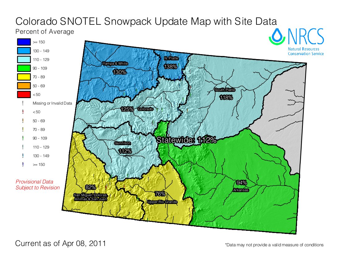
Denver Water’s Moffat Collection System Project is designed to provide 18,000 acre-feet per year of new water supply to firm up the yield from Denver’s existing water rights on the West Slope, primarily by enlarging Gross Reservoir near Boulder and diverting additional water from the Fraser and Williams Fork rivers.

This project’s likely impacts include reduced stream flows and increased temperatures in the Williams Fork, Fraser and Upper Colorado River systems. The lower flows may increase sedimentation in the affected reaches of these rivers and reduce their ability to support aquatic insects and fish life. The lower flows may also reduce the ability of the river channel maintain hydrologic function over the long term.

On the East Slope, the additional diversions would send more water through the Moffat Tunnel, down South Boulder Creek and into an enlarged Gross Reservoir. The project would create a larger reservoir for recreation, but longer periods of high flows in South Boulder Creek above Gross Reservoir would reduce its ability to support trout and other aquatic wildlife.

To mitigate likely impacts from the project on the Fraser River and upper Williams Fork River, Denver is proposing to fund a Colorado River cutthroat restoration project and other aquatic habitat restoration work. On the Colorado River, Denver would install two real-time temperature monitoring gages and agree to release water in August if high temperatures threatened fish.

East of the Divide, Denver would rebuild the Gross Reservoir Dam larger than necessary to allow Boulder and Lafayette to store water to maintain stream flows during winter months, create new wetlands to replace wetlands inundated by the larger reservoir and monitor stream channel stability to identify impacts from higher flows.

Northern’s Windy Gap Firming Project is designed to provide 30,000 acre-feet per year of new water supply to firm up the yield from its existing water rights in the Upper Colorado River by diverting additional water to the proposed new Chimney Hollow Reservoir west of Longmont.

West of the Divide, impacts could include a decrease of water level in Lake Granby, a reduction in trout habitat in the Colorado River due to lower stream flows and increases in water temperature. There would also likely be a reduction in river flows preferred by rafters and kayakers, with a potential impact on anglers who fish from personal floatation equipment. Fisheries east of the Continental Divide would benefit from potential development of a new flat-water fishery in the proposed Chimney Hollow Reservoir, though some wetlands and big game habitat would be flooded by the new reservoir.

To mitigate impacts from the project on the Upper Colorado River system, Northern is proposing to manage their pumping to maintain water levels in Lake Granby and look for ways to improve flushing flows and provide cooler summer water temperatures in the Upper Colorado River below Windy Gap Reservoir. Northern would contribute to water quality projects to reduce nutrient loading in Shadow Mountain, Lake Granby and Grand Lake. East of the Divide, Northern is proposing to replace lost wetlands and improve enhance wildlife habitat near the new Chimney Hollow Reservoir.

Under state statute, the Commission’s authority is limited to a review of plans to mitigate impacts from proposed projects. Restoring the river to a past condition is beyond the scope of the project approval process and Wildlife Commission authority. However, Denver and Northern are voluntarily proposing steps to address impacts of existing water development projects to fish and wildlife resources on both sides of the Continental Divide by enhancing current conditions.

The enhancement plans would support the Upper Colorado River Habitat Project, a collaborative plan that is designed to restore a more functional channel system and improve habitat for trout and other important aquatic species between Windy Gap Reservoir and the Kemp-Breeze State Wildlife Area.

With the plans submitted, the Division has 10 days to perform a completeness review of the proposals. When the Wildlife Commission submits its recommendation to the Colorado Water Conservation Board, the CWCB will then have 60 days to affirm the Commission’s recommendation as the official state position or modify the recommendation. If the CWCB makes revisions, the Governor will have 60 days to affirm or further modify the recommendation, which then becomes the official state position with regard to mitigation. The final state position is then transmitted to the appropriate federal permitting agencies.

Also during Thursday’s morning session, the Commission received a presentation on draft regulations to amend the existing prohibition on dogs at Lon Hagler and Lone Tree Reservoir State Wildlife Areas near Loveland.

Under the proposed change, dogs must be on a leash less than six feet long, unless they are on a boat. In addition, dogs would be prohibited from portions of both properties during certain times of the year except as an aid to hunting. The current dog ban would be maintained around the Lon Hagler annex pond and adjacent land to protect wildlife habitat. The Commission is scheduled to consider final approval of the change at the May meeting in Salida.

The Commission also heard a presentation on a mule deer research proposal for Middle Park that will help Division biologists better manage deer herds across the state. The proposed study is designed to measure natural buck survival under different harvest structures. During the study, buck hunting pressure would be maintained at current levels throughout the Middle Park data analysis unit for three years. During the following four years, harvest rates on half of the unit would be increased while harvest rates would be decreased on the remaining half of the unit. Natural buck survival would be measured on each half of the unit when hunting season is closed.

The results will help biologists understand the impact hunting pressure has on the survival of mule deer bucks and their subsequent availability for harvest, and improve the Division’s ability to inform sportsmen of tradeoffs between managing for big bucks and hunter opportunity.

The Wildlife Commission meets monthly and travels to communities around the state to facilitate public participation in its processes. During the rest of 2011, the Commission is scheduled to meet in Salida in May, Grand Junction in June and in locations to be determined from July through December.

The complete agenda for the April Wildlife Commission workshop, as well as a discussion of proposed regulation changes for Lon Hagler and Lone Tree state wildlife areas, can be found on the Wildlife Commission web page at: http://wildlife.state.co.us/WildlifeCommission/Archives/2011/April72011.htm.

More information on Denver Water’s Moffat Collection System proposal and Northern’s Windy Gap Firming Project may be found here: http://wildlife.state.co.us/LandWater/Water/MoffatWindyGapMitigationProjects/.

The Colorado Wildlife Commission is an 11-member board appointed by the governor. The Wildlife Commission sets Division of Wildlife regulations and policies for hunting, fishing, watchable wildlife, nongame, threatened and endangered species. The Commission also oversees Division of Wildlife land purchases and property regulations.

More Moffat Collection System Project coverage here and here. More Windy Gap coverage here and here.

Rio Grande River basin: San Luis Valley’s first groundwater management sub-district update — accounting growing pains

A picture named riograndebasin.jpg

From the Valley Courier (Ruth Heide):

In its annual meeting this month, the sub-district board of managers struggled with some of those kinks, most of them surrounding water accounting issues. Although the sub-district itself has been approved, its plan of management is currently under appeal at the Colorado Supreme Court level. Because of the court appeal, fees collected for the sub-district for the first time this year must essentially be held in escrow. If/once they are freed up, funds can be used for such purposes as sub-district staff and water acquisition…

In addition, several potential water sellers have already approached the district and sub-district to sell replacement water, which the sub-district cannot buy until its funds are cleared, assuming the state court appeal goes in the sub-district’s favor. One of the main purposes for the sub-district, which lies in the Valley’s closed basin area, is to replenish well-pumping depletions to surface rights. Vandiver said a number of people have offered replacement water, including the San Luis Valley Conservancy District and a local real estate company with a ranch for sale on La Jara Creek. The ranch comes with senior water rights. Jim McCullough, who attended the sub-district board’s April 5 meeting, also offered for consideration shares he owns on the Excelsior Ditch. He said he would like to find a way to use that water to replace the depletions he owes within the sub-district. Vandiver said he had fielded several inquiries from people who wanted to use surface water that is not part of the sub-district as augmentation water…

Recharge credits are another area where the sub-district board is fine tuning the details. Board and audience members questioned how recharge would be credited to farmers who had recharge reservoirs, flood irrigated or in other means replaced water to the aquifer. For example, Monte Vista area farmer Dick McNitt said he felt like he was being penalized for his conservation efforts through reservoirs on his property. The board and audience also talked about reconsidering how surface water credits are calculated, and Sub-district Board Chairman Lynn McCullough appointed a committee to review that portion of the plan and develop recommendations. The committee includes board members and some of the audience members who requested to be a part of the discussion…

One issue that was easy to resolve during the board’s annual meeting was the election of officers. The board unanimously voted to keep the same slate of officers, with Lynn McCullough as chairman.

More San Luis Valley groundwater coverage here and here.

Southern Delivery System update: Comments on the contracts to use Fryingpan-Arkansas project facilities close April 25

A picture named sdspreferredalternative.jpg

From The Pueblo Chieftain (Chris Woodka):

The contracts will allow Colorado Springs, Fountain, Security and Pueblo West to store water in Lake Pueblo, connect a pipeline to Pueblo Dam and change the operation of the Fountain Valley Conduit. Colorado Springs also will have the ability to move water upstream through a paper trade.

“We have not received any comments on the draft contracts,” said Kara Lamb, spokeswoman for the Bureau of Reclamation. Deadline for comments is April 25.

Colorado Springs Utilities expects to begin construction of the SDS project in Pueblo County beginning next month. While SDS was raised as a campaign issue in Colorado Springs elections, all seven council candidates elected last week, as well as the two other members, are supporters of SDS…

Construction on the North Outlet Works, a new connection to the dam, will begin in May. The lead contractor is ASI Constructors of Pueblo West. Construction on pipelines through Pueblo West and through Walker Ranches in northern Pueblo County is scheduled to begin in late summer. Some construction has begun in El Paso County, and fabrication of parts for the dam connection is nearly complete…

As part of SDS, however, each community will store water in excess-capacity accounts in Lake Pueblo beginning this year. Lake Pueblo was built as part of the Fryingpan-Arkansas Project, authorized by Congress in 1962. Nonproject water can be stored in most years. Excess capacity space in Lake Pueblo will be allocated at $36 per acre-foot with an increase of 1.79 percent annually over the 40-year life of the contract with the four communities. For the first seven years of storage, the bills will be reduced by a total of $6 million in recognition of oversizing the initial quarter-mile of pipeline from Pueblo Dam to the Juniper Pump Station. Once that section of pipeline is completed, it will be deeded to Reclamation. Consequently, payments through 2017 will total about $760,000. Payments from the four communities will total more than $1.25 million in 2018, and will increase each year by terms of the contract and as more water is stored.

More Southern Delivery System coverage here and here.

Western Governors’ Water Policy Arm to Consider Water Sharing Recommendations This Week in Santa Fe

A picture named irrigation.jpg

Here’s the release from Colorado State University (Emily Wilmsen):

The Western States Water Council – the water policy arm of the 18 Western Governors – this week will consider recommendations from diverse Western water leaders representing agricultural, environmental, and urban interests.

The report – “Agricultural/Urban/Environmental Water Sharing: Innovative Strategies for the Colorado River Basin and the West” – is the result of convening representatives from The Nature Conservancy, Family Farm Alliance, Western Urban Water Coalition and two dozen others who set aside long-held positions and built new alliances for creative water sharing strategies for mutual benefit. The full report is available at http://www.cwi.colostate.edu/watersharing.

Colorado State University’s Colorado Water Institute facilitated the meetings and produced the report as a response to a 2008 challenge by the Western governors: “States, working with interested stakeholders, should identify innovative ways to allow water transfers from agricultural to urban uses while avoiding or mitigating damages to agricultural economies and environmental values.” The project was funded by the Walton Family Foundation.

Some strategies detailed in the report include:

• Farmers and cities in Arizona trading use of surface water and groundwater to the advantage of both;

• Ranchers in Oregon paid by environmentalists to forego a third cutting of hay to leave water in the stream for late summer fish flows;

• A ditch company in New Mexico willing to sell shares of water to New Mexico Audubon for bird habitat on the same terms offered to a new farmer to grow cantaloupe;

• A California flood control and water supply project creatively managed to meet multiple goals of restoring groundwater, maintaining instream flows for wild salmon and steelhead, and providing water for cities and farms;

• Seven ditch companies cooperating in Colorado in a “Super Ditch” scheme to pool part of their water through rotational fallowing, for lease to cities, while maintaining agricultural ownership of the water rights.

“While these strategies sound like good common sense, they all face sizable obstacles,” said Reagan Waskom, director of the Colorado Water Institute. “If we want to share water for the benefit of all, we need a lot more flexibility, all members of the group agreed.”

The group’s recommendations to the Western Governors were developed to provide that flexibility, Waskom said.

Highlights of the recommendations:

• Design robust processes that give environmental, urban and environmental stakeholders opportunities to plan together early on, instead of one-sided “decide, announce, defend” processes that frequently result in opposition and polarization.

• Foster a flexible, watershed based approach that can lead to cross-jurisdictional sharing of infrastructure, cooperatively timed water deliveries, and strategies to facilitate real-time, on-the-ground, state-of-the-art water management for optimal benefit of cities, farms, and the environment.

• Break down legal, institutional, and other obstacles to water-sharing strategies by developing criteria and thresholds that protect agriculture, the environment and any third parties to water sharing transactions. And experiment with creative approaches such as “water resource sharing zones” that could be set up for trading of water, financial resources, and even locally grown food while encouraging interaction between agricultural, environmental, and urban neighbors.

• Expedite the permitting process when programs or projects have broad support of agricultural, urban, and environmental sectors.

• A governor-championed federal/state pilot review process should be established where a state liaison and a federal designate are appointed to co-facilitate concurrent agency review and permitting without repetitive, costly information exchanges. Permitting is important to protect environmental, economic, and social values, the group agreed, but cumbersome permitting processes often lasting years need an overhaul.

In coming months, group members will meet with environmental, agricultural, and urban groups throughout the Colorado River Basin and the West to encourage further dialogue.

More coverage from Chris Woodka writing for The Pueblo Chieftain. From the article:

Included in the report are the Arkansas Valley Super Ditch and guidelines for water transfers developed by the Arkansas Basin Roundtable, as well as a description of $3 million in state projects looking at how water resources can be shared. Colorado State University’s Colorado Water Institute developed the report, along with The Nature Conservancy, Family Farm Alliance, Western Urban Water Coalition and about two dozen others who participated in brainstorming sessions to find ways to share water in order to satisfy agricultural, environmental and urban interests. It grew out of a 2008 challenge by governors to identify innovative water transfers, and was funded by the Walton Family Foundation. The report looked at water-sharing programs in California, Arizona, Oregon, Wyoming and New Mexico as well as Colorado. Everything from water banks to lease programs like Super Ditch were considered.

Recommendations included basinwide planning and development of projects, breaking down barriers to water transfers and finding creative, flexible approaches that are acceptable to urban, rural and environmental concerns.

Creede: The second annual High Country Hustle — a run/walk for water April 17

A picture named creede1920

From the Mineral County Miner:

The Second Annual High Country Hustle, a 6.6K Run/Walk for Water, will be held on April 17 from 1:30 p.m. to 4:30 p.m. in Creede. The 2011 High Country Hustle is an opportunity for the community and state to come together to raise awareness about water issues and raise funds for river restoration activities on the Rio Grande.

  There is a $25 event fee, which will include an event t-shirt, a gift bag and post-run/walk refreshments. All monies raised will go toward the event organizers’ goal of raising $10,000 and will be donated to the Rio Grande Headwaters Restoration Project. The Mission of the Rio Grande Headwaters Restoration Project is “to restore and conserve the historical functions and vitality of the Rio Grande in Colorado for improved water quality, agricultural water use, riparian health, wildlife and aquatic species habitat, recreation and community safety while meeting the requirements of the Rio Grande Compact.”

More restoration coverage here and here.

NRCS: The April 1 Basin Outlook Report for Colorado is hot off the presses

A picture named snotelsite.jpg

Here’s the link to the April 1 report. I like to keep track of the outlook for the Dolores River. From the report:

The combined San Miguel, Dolores, Animas and San Juan River basin snowpack took another hit during March dropping to 86 percent of average on April 1. This is 85 percent of last year’s snowpack at this time. This is the seventh time that the April 1 snowpack has been below average in the last ten years. Given that the basin reaches its average peak snow water content on April 7, barring some record breaking event, there is virtually no chance that the snowpack will reach that level.

Northern Colorado Water Conservancy District annual spring water users meeting recap: Expansion of Halligan and Seaman reservoirs still ongoing

A picture named poudrereservoirexpansion.jpg

From The Greeley Tribune (Bill Jackson):

Nancy Koch, a water acquisition specialist with Greeley, and Cliff Hoelscher, project manager for Fort Collins, gave updates at Thursday’s spring water users meeting of Northern Colorado Water Conservancy District of where each are with expansion plans of Greeley’s Milton Seaman Reservoir and Halligan Reservoir, which Fort Collins owns and operates in conjunction with the North Poudre Irrigation Co…

Greeley has owned Seaman Reservoir since 1943. It is just north of the Poudre River and holds 5,000 acre feet of water. Greeley’s plan is to expand that to 53,000 acre feet, which Koch said will help the city maintain use of existing water and help meet future demands. It is the city’s intent, she said, to have that expansion completed by 2030.

Halligan Reservoir will expand from its present 6,400 acre feet of storage to 22,500 acre feet. It was originally owned and operated by the North Poudre Irrigation Co., but that company and Fort Collins reached an agreement in 2003 that gave the city ownership and joint operational duties with the irrigation company. It is north of Seaman Reservoir. Its expansion is proposed to be completed by 2016.

More Poudre River watershed coverage here.

Irrigation and ditch company primer

A picture named measuringwithweir.jpg

Here’s a primer of sorts about irrigation and the operations of ditch companies, from Nancy Argo writing for The Durango Herald. Click through and read the whole thing. Here’s an excerpt:

Because the arid West does not receive enough natural rainfall each year to adequately grow crops, agricultural landowners began to control water from rivers and reservoirs for irrigation. The Colorado Constitution provides that the waters of every natural stream are the property of the people of the state of Colorado who have the right to divert the unappropriated water of any natural stream to beneficial use, thus creating a “water right” that may be decreed by a court. Because lands where water is used are often located away from streams and rivers, ditches may be constructed to carry the water to agricultural land.

Energy policy — oil and gas: FracFocus.org debuts today

A picture named hydraulicfracturing.jpg

From NBC11News.com (Cecile Juliette):

Mesa County Commissioner Craig Meis has been in the oil and gas business for 20 years. He’s also a chemical engineer. Commissioner Meis says that this website may not be very helpful to citizens who aren’t familiar with the fracking process. He says, “the chemical names are going to be relatively unknown to most people.” But he adds that the website will at least offer disclosure in case people are interested in doing the research into the fracking process.

Tara Meixell is author of “Collateral Damage,” a book about the oil and gas industry. She’s also working with MIT on the “The Extr ACT Project.” It’s a Wikepedia-based project for public-information sharing on gas and oil development impacts and resource issues. It also includes input from citizens in affected areas. Meixsell also served as consultant on the movie “Gaslands,” a film about the impact of natural gas extraction. She says the new website is, “a good first step in providing the public information on hydraulic fracturing chemicals and processes. However, voluntary participation can’t and won’t take the place of state and federal regulations.”

More oil and gas coverage here and here.

U.S. Representative Cory Gardner: ‘No technological advancement has ever had the singular power to transform society and economy like the application of water to dry land’

A picture named nisp2

Here’s a guest column from Representative Gardner running in the Sterling Journal Advocate. Click through and read the whole thing. Here’s and excerpt:

While new technologies have transformed the agricultural and urban landscapes over the past 100 years, no technological advancement has ever had the singular power to transform society and economy like the application of water to dry land. Visionary Coloradans Wayne Aspinall and W.D. Farr took leadership roles to create the infrastructure that waters our state today. Their work has stretched well beyond a generation, but as populations grow and demands increase, that work is now stretching thin. It is time for our generation to pick up the mantle and provide the water leadership for our future.

Here’s guest column about the Northern Integrated Supply Project, from Eric Doering the mayor of Frederick running in The Greeley Tribune. Here’s an excerpt:

[The Northern Integrated Supply Project] is an integral part of the long-term health of our community and the other participants involved. It is the most proactive partnership to be seen by the communities and water districts and will result in an ability to meet the long-term needs of our population both current and future…

Growth will continue in the Front Range communities along the Interstate 25 corridor. We must be poised to meet those growing demands of primary employers and others who desire to have their workforce live, work and play in the community in which they establish their businesses. The NISP participants are gathering support for this project from a varied group of individual and business leaders, as well as chambers of commerce and agricultural interests. To date, the participants have spent more than $9 million to work through review and design processes, and it is now with the U.S. Corps of Engineers to review and indicate whether the project can move forward. Many political leaders from both parties are supporting this project.

Most of the largest communities along the North Front Range were foresighted many years ago to ensure their water portfolio and participated in projects similar to NISP. It is now time for Frederick, Erie, Firestone, Windsor, Dacono and other communities to have that same shared vision and commitment to adequate and reliable water for future use.

More infrastructure coverage here.

Snowpack/drought news: San Miguel, Dolores, Animas, and San Juan River Basins sitting at 82 percent of average

A picture named snowpackcolorado04082011

From The Telluride Daily Planet (Ellen Metrick):

Last week, when [Jim Boyd] and his co-worker John Lestina of Dove Creek measured the local snowpack, they came up with a below-average average over four sites. North Mountain, near Miramonte Reservoir, is at 98 percent of average snowpack, but Trout Lake area measured at 74.6 percent, and in the town of Telluride, the snowpack moisture content is at 67 percent. The fourth site, on Lizard Head Pass, is close to 85 percent. Overall, the snow water equivalent for the San Miguel, Dolores, Animas, and San Juan River Basins measure at 84 percent. The highest in the state — the Laramie and North Platte River Basin — is at 138 percent of average, while the lowest — the Upper Rio Grande Basin — is at 75 percent. In addition to the moisture content of the snow, other factors come into play, as well — spring winds can suck the moisture out of the snowpack, and above-average temperatures could melt it more quickly, reducing the amount of water available later. In the Norwood area, where water storage is limited and spring “natural-flow” irrigation is a common event, a fast run-off can be a concern.

From The Greeley Tribune (Bill Jackson):

The problem, [Karen Rademacher, a senior water resources engineer for the Northern Colorado Water Conservancy District] said, is there’s only room enough to store about 215,000 acre-feet of water. As a result, Northern Water will start spilling water out of Granby Reservoir, the main collection point of the Colorado-Big Thompson Project, before that runoff starts next month. The Colorado-Big Thompson brings a supplemental water supply to the northeast part of the state from the Colorado River. While that means there will be a lot of water flowing down not only the Colorado, but the Big Thompson, Poudre, St. Vrain and South Platte rivers as well this spring, while the eastern part of the state remains in the grips of a moderate to extreme drought. Rademacher said the most recent outlook calls for those drought conditions to continue into the spring months. “The water equivalent of the snowpack is spectacular. It’s the biggest year we’ve seen since 1986, but at the same time, we’re seeing conditions on the eastern plains that are similar to what we saw in the drought of 2002,” Rademacher said…

As a result of those conditions, Dave Nettles, division engineer with the Colorado Division of Water Resources in Greeley, said there already have been calls for irrigation water along northern rivers, such as the South Platte, which have come a little earlier than normally expected. At the same time, the major reservoirs along the South Platte and its tributaries, are at near capacity, he noted. But Nettles also said there have been below-average flows on the South Platte and other rivers since July and August of last year, noting the majority of the water coming from this year’s snow melt will be used along the Front Range by senior water right holders.

Conservation: Boulder city agencies cut consumption 19 percent over the past three years

A picture named boulderreservoir.jpg

From the Boulder Daily Camera (Heath Urie):

“We’ve decreased our usage by 19 percent,” said Joanna Crean, a project manager for the city’s public works department. A recent report to the City Council shows that some city departments saw double-digit reductions in their water consumption between 2008 and 2010. Conservation efforts and fixing leaky pipes helped the Housing and Human Services division reduce its water use by 34 percent, while the Boulder Municipal Airport used 33 percent less water and Boulder police used 15 percent less water over the past three years. In total, the city has reduced its indoor water use by 5.5 million gallons, while its outdoor water usage has dropped by 43.3 million gallons.

More conservation coverage here.

Snowpack/Precipitation news: Grand County is taking an early look at potential flooding

A picture named cherrycreekflood08031933castlewooddamfailure.jpg

From the Sky-Hi Daily News (Tonya Bina):

If this spring is anything like last year when the high country experienced consecutive hot days during peak runoff, there’s a chance of flooding, officials say.

Snowpack in the Upper Colorado River Basin contains 142 percent of the average water content for this time of year, meaning it’s a “pretty robust year” for snowpack, said Northern Colorado Water Conservancy District spokesperson Dana Strongin. In fact, in an April 5 “Runoff Update,” Northern blogged: “Some of us are using words like ‘epic’ to describe the West Slope snowpack.”

The Grand County Office of Emergency Management has held its first meeting with town managers and public works directors to talk about planning for high water levels and coordinating with dam operators…

The Fraser River Basin is at about 136 percent of average for snowpack water content…

The Northern Colorado Water Conservancy District is planning controlled releases out of Granby Dam in its preparation for the runoff season. As of Wednesday, April 6, Granby Dam elevation sat at 22 feet from full. Willow Creek snowpack is at 150 percent of average. Beginning April 6, releases from Granby Dam into the Colorado River increased by 60 cfs. Another increase brought the flow below the dam to 140 cfs. Another change on Friday is planned to bring the flow to about 200 cfs through the weekend. Northern is also making changes at Willow Creek Dam. Flows in Willow Creek below the dam could be as high as 350 cfs.

From the Snowmass Sun (Scott Condon):

Skiers and riders have been treated to powder days with four or more inches of fresh snow on 29 days this season at Snowmass and 23 days at Aspen Mountain. Chances are they might score more before the two ski areas close Sunday. Snowmass has collected the most snow of the four local ski areas, tallying 316 inches so far this season since Nov. 1, according to the Aspen Skiing Co. Snow is forecast for Friday through Sunday.

Lincoln Park/Cotter Mill superfund site update: Trichloroethene is spreading in the groundwater around the site

A picture named lincolnparksuperfund.jpg

From The Denver Post (Bruce Finley):

State regulators Friday confirmed [trichloroethene] in the toxic and radioactive waste from the mill, adjacent to Cañon City, and said they’ve asked Cotter to investigate. “It’s in the groundwater. It’s not in the public drinking water supply that we know of,” said Jeanine Natterman, a spokeswoman for the Colorado Department of Public Health and Environment.

Cañon City’s 16,000 residents, many of whose wells already are tainted, received no notification. “Nothing surprises me anymore,” because the plant “is like an octopus with 20 arms,” said Sharyn Cunningham, 64, who lives 1 1/2 miles away and co-chairs Colorado Citizens Against Toxic Waste.

More Lincoln Park/Cotter Mill superfund site coverage here.

Colorado River Basin: The impacted nature of the riparian environment at the headwaters should drive the environmental analysis of moving more water to the Front Range

A picture named eisenhowerfishing.jpg

Guaranteed flows would be a great start. Flushing flows at times. Something similar to the settlement over flows through Black Canyon. Click here for a video of the Crystal Dam Spill last May (William Woody and The Grand Junction Daily Sentinel).

Here’s a report about current impacts from Scott Willoughby writing for The Denver Post. From the article:

…the network of pipes eventually grows to include tunnels with names like Harold D. Roberts, Gumlick, Vasquez and Moffat that stretch across the Divide to move acres of water out of the Blue, Williams Fork, Fraser and other mountain streams. Rather than joining the collective headwaters that unite to form fish and wildlife habitat in the Colorado River, that water winds up in sprinklers and car washes, beer bottles and bathroom spigots along the Front Range.

More of that water is targeted for removal as Colorado’s population continues to swell. Proposals on the table from Denver Water and Northern Water Conservancy District to divert additional water from the Fraser, Williams Fork, Blue and Upper Colorado rivers are designed to keep water supply ahead of demand in municipalities from Denver to Greeley.

Yet, even as the water entities lay out plans required to mitigate the impacts on fish and wildlife from their Moffat Collection System and Windy Gap Firming Project, it’s increasingly evident that these troubled waters can’t accommodate the demands already placed on them. Aquatic species ranging from green drake mayflies to mottled sculpin minnows already have disappeared, whatever the blame. The whole situation is a hot mess. We can’t manufacture water. And apparently we can’t manage it very well, either.

More Moffat Collection System Project coverage here and here.

Nolan Doesken snags the President’s Award from the Colorado Foundation for Water Education

A picture named nolandoesken1

Nolan Doesken, Colorado’s State Climatologist, was presented with the President’s Award yesterday evening.

He asked, “I’m feeling naked because I don’t have a what?”

The answer to his question was a rain gauge, of course. He often carries a rain gauge with him as he travels around the state to speak to groups about Colorado’s climate and the Community Collaborative Rain, Hail & Snow Network (CoCoRaHS). Actually, I’ve seen Nolan speak many times over the years and I don’t remember a time that he didn’t have a rain gauge with him.

Nolan credits his father for nurturing his interest in weather. He reminisced about buying his father a rain gauge in the late 60s. His father, he said, kept a journal of precipitation records, carefully recording data from a gauge that was only accurate to the nearest quarter inch of moisture. While that may have been accurate enough for Illinois where Nolan grew up, “In Colorado you sort of need that nearest hundredth,” he said.

He describes his work as a, “Never ending roller coaster ride because we never know what the next week or the next month will bring.” He says he spends his time, “Telling stories with numbers.”

The big effort for CoCoRaHS over the next year — in conjunction with Colorado Water 2012 — will be to get rain gauges into all schools in Colorado. Doesken hopes that the schools will participate in the program for at least part of the year.

As I wandered around the reception I sensed a general feeling of admiration and respect for Doesken from everyone I talked with. In point of fact he is genuinely well liked by those that know him and work for him. One person told me, “You’ll never hear anyone say anything bad about Nolan.”

Congratulations Mr. Doesken the award is well deserved and don’t worry, I remember where I can purchase my very own weather station and sign up to be part of the network, http://www.cocorahs.org/.

2011 Colorado legislation: State Joint Budget Committee approves preserving a floor of $10 million of severance tax revenues for water projects

A picture named fountainpavementdrawing.jpg

From the Sterling Journal Advocate (Marianne Goodland):

[JBC member Rep. Jon Becker] negotiated a lower cash transfer from a severance tax fund, an agreement that he said will preserve at least $10 million and maybe more for water projects…

[Sen. Greg Brophy] lauded [Rep. Jerry Sonnenberg] and especially Becker for making sure HB 1005 would pass. “Jon ensured that the money was there for the ag tax exemption, and he also made sure we put [millions more] into water projects. We cannot continue to fall behind in developing our water infrastructure.”

More 2011 Colorado legislation coverage here.

Lake Mead news: Reclamation forecasts a strong runoff season for the upper Colorado River basin, the bounty should help the reservoir fill a bit more

A picture named drylakemead.jpg

From The Arizona Republic (Shaun McKinnon):

The U.S. Bureau of Reclamation said Friday that runoff from snow in the mountains of Wyoming and Colorado is expected to increase storage on the river enough to adjust water levels at two key reservoirs and avert drought restrictions. The decision comes just six months after Lake Mead dropped to within 7 feet of a level that would have triggered drought restrictions. Under those restrictions, Arizona would have lost about 11 percent of its allocation for at least one year.

Arizona officials had prepared contingency plans that included forfeiting a small amount of the state’s allocation as a hedge against larger losses. Those plans are no longer necessary. “We still want to be somewhat cautious,” said Tom McCann, assistant general manager of the Central Arizona Project, which delivers Colorado River water to Phoenix and Tucson. “We’ve been in drought for 11 years. We’ve had a good year, and that’s very helpful. It pushes us further away from shortages, but it doesn’t mean the drought is over.”

Still, Friday’s action will give the CAP and other water users more time to plan for future shortages. The extra water should postpone the potential for shortages until about 2016, even if conditions turn dry again, McCann said.

More Colorado River basin coverage here.

Colorado-Big Thompson Project update: The Northern Colorado Water Conservancy District sets an 80 percent quota for project water

A picture named coloradobigthompsonmap.jpg

Here’s the release from the Northern Colorado Water Conservancy District (Brian Werner):

An 80 percent quota for Colorado-Big Thompson Project water was agreed upon today by the Northern Water Board of Directors. The quota is a 30 percent increase from the initial quota set by the Board for this water year, effective Nov. 1, 2010.

The quota establishes the percentage of an acre foot that a C-BT allottee will receive during the current water year for every unit of C-BT water the allottee owns. The 80 percent quota means that each unit will yield eight-tenths of an acre foot.

Every year the Board bases its April quota decision on updated snowpack and storage information while striving to balance the overall water needs within Northern Water’s district boundaries. This year, the Upper Colorado River Basin’s snowpack is 42 percent above average, and C-BT reservoir storage is also above average. However, Board members said that dry conditions on the East Slope are a significant concern.

They said an 80 percent quota would help farmers who are trying to get their crops started in low soil moisture conditions. Precipitation in Northeastern Colorado is 30 percent below average year to date.

Several Board members emphasized that they want to revisit the quota in May. The Board has the ability to increase the quota in subsequent meetings.

“We want to watch precipitation. We’ll keep an eye on things and consider a supplemental quota next month,” said Director Bill Brown from Larimer County.

The quota will make 248,000 acre feet of C-BT water available to agricultural, municipal and industrial users within Northern Water’s boundaries until the end of the water year on Oct. 31, 2011.

Thanks to The Greeley Tribune for the heads up.

More Colorado-Big Thompson coverage here.

Snowpack news: Statewide reservoir storage about average while snowpack is 112 percent of average

A picture named snowpackcolorado04082011

What are the similarities between 2002 and this water year? Here’s a report from Chris Woodka writing for The Pueblo Chieftain. From the article:

“The difference between this year and 2002 is that we have a huge snowpack,” said Alan Ward, water resources administration for the Pueblo water board. “Going into 2002, there was a triple whammy: no snow in the mountains, a dry spring and no rain that summer.”[…]

Precipitation is actually looking better this year, so far. By April 8, 2002, Pueblo had received only 0.54 inches of moisture in 2002, compared with 1.54 inches so far this year. That’s about 85 percent of average for early April. Pueblo officially had only 3.94 inches of precipitation in 2002, the driest year on record and about one-fourth of average.

In April 2002, statewide snowpack was 52 percent of normal, while reservoir storage was 55 percent of average. This year, Colorado snowpack is about 110 percent of average and reservoir storage is right at average.

The 2002 drought actually was the third year of a statewide drought that primarily affected the Colorado River basin, while the effect was masked by wet summers in the Arkansas Valley. Colorado has had average-to-wet years in the four years prior to 2011.

Fryingpan-Arkansas Project update: Reclamation is turning up releases from Ruedi Reservoir

A picture named ruedidam.jpg

From email from Reclamation (Kara Lamb):

Similar to last year, we have begun to see a slight increase to Ruedi Reservoir inflow in early April, rather than mid-to-late April as in other years. As a result, this evening (April 8th) we will increase our release from Ruedi Dam to the lower Fryingpan River. In a couple of hours, we will raise the release from Ruedi by about 40 cfs.

The result will be about 220 cfs by the gage below Ruedi Dam. The current reservoir elevation is around 7721 feet and still creeping down. Our increased release will keep the reservoir dropping, slightly, making room for the snow pack run-off we are anticipating late next month.

I’ve updated the Ruedi webpage to reflect these changes. Please give it a look and let me [Kara] know what you think: http://www.usbr.gov/gp/ecao/ruedi.html

We also have an additional snow pack and water level page now available at http://www.usbr.gov/gp/hydromet/curres_google.htm. Please give that a look as well.

More Fryingpan-Arkansas Project coverage here.

Aspinall Unit update: The Uncompahgre Valley Water Users Association is calling for water, an additional 100cfs will be diverted at the Gunnison Tunnel

A picture named gunnisontunnelnps.jpg

From email from Reclamation (Dan Crabtree):

The Uncompahgre Valley Water Users Association (Water Users) continue to fill canals for the irrigation season and are in immediate need of additional water from the Gunnison River. The only operating powerplant at Blue Mesa Dam is operating at full capacity and the bypass tubes will not be operational until next week. Therefore the Water Users will divert another 100 cfs at the Gunnison Tunnel which will reduce flows in the river by a corresponding amount. The result will be a flow of about 1,300 cfs in the Black Canyon and Gunnison Gorge.

More Aspinall Unit coverage here.

Poudre River watershed: ‘The Poudre Runs Through It’ final installment — public dialogue — April 11

A picture named cachelapoudreriver.jpg

From the editorial staff of the Northern Colorado Business Report:

The final public dialogue portion of the program will be held in two sessions in Fort Collins: Monday, April 11, from 6 to 8:30 p.m. at the Timberline Church on South Timberline Road, and Saturday, April 16, from 2:30 to 5 p.m. at The Drake Center on West Drake Road. These sessions, facilitated by CSU’s Center for Public Deliberation, will be where we all can discuss alternatives for Northern Colorado’s water future.

To prepare for the public deliberation and to see recordings from previous sessions of The Poudre Runs Through It, go online to www.univercityconnections.org/.

More Poudre River watershed coverage here.

Water Education Foundation to Honor State Climatologist at Colorado State University tonight

A picture named nolandoesken042011

Here’s the release from Colorado State University (Emily Wilmsen):

Nolan Doesken, state climatologist and founder of CoCoRaHS, the Community Collaborative Rain, Hail, and Snow Network based at Colorado State University, today will receive the 2011 President’s Award from the Colorado Foundation for Water Education.

Doesken will receive the award in recognition of his advancement to greater understanding of Colorado’s climate and water resources.

Doesken founded the volunteer precipitation monitoring program, CoCoRaHS, as a small local project in Fort Collins soon after an extreme localized storm in 1997. The storm was not well detected by traditional weather observing networks and caused devastating flooding. For this effort, the National Oceanic and Atmospheric Administration honored him as one of 10 “Environmental Heroes” in 2007.

NOAA’s Office of Education awarded CoCoRaHS an Environmental Literacy grant in December 2006 to make its first formal push to expand nationally. Since then, CoCoRaHS has grown to include nearly 15,000 volunteers nationwide.
CoCoRaHS taps volunteers of all ages to document the quantity, intensity, duration and patterns of precipitation by taking simple measurements in their own backyards. Volunteers only need a cylindrical rain gauge, some training and an interest in weather to participate in the program.

Doesken will receive the award during the Colorado Foundation for Water Education’s 2011 President’s Award reception from 6-9 p.m. Friday, April 8, at the National Center for Atmospheric Research’s Mesa Laboratory in Boulder. For more information, go to http://www.cfwe.org/index.php?option=com_content&view=category&layout=blog&id=64&Itemid=89.

The Colorado Foundation for Water Education is Colorado’s only non-profit, non-advocacy organization that provides water resource information and education. Their mission is to promote better understanding of Colorado’s water resources and issues by providing balanced and accurate information and education. For more information about the CFWE, go to http://www.cfwe.org.

More coverage from the Associated Press via The Denver Post:

Hannah Holm, coordinator of the Mesa County Water Association, has received the Emerging Leader Award…Holm’s work with the Mesa County group includes organizing water education activities and encouraging western Colorado residents, water managers and officials to work together.

Snowpack news: The San Luis Valley continues to dry up ahead of the runoff season

A picture named snowpackcolorado04072011

From the Valley Courier (Ruth Heide):

As of Tuesday, the Rio Grande Basin that encompasses the San Luis Valley was sitting at 75 percent of average basin wide, factoring the western San Juan Mountains in with that 41 percent for the Sangre de Cristo Mountains. Just the week before, the basin-wide average was 80 percent.

The tops of the Sangres now look more like they usually do in May, water attorney David Robbins related to members of the Sub-district #1 board during its annual meeting on Tuesday. He said generally this time of year when he flies into the Valley from the Denver area, he can see big snowfields in the Sangre de Cristo Mountains, but this year those snowfields are already gone. “It looks like May even in the protected interior,” he said…

Colorado Division of Water Resources Division Engineer for Division 3 Craig Cotten said the annual forecasted stream flow for the Rio Grande at Del Norte is also below average, with about 505,000 acre feet predicted for the calendar year, or 78 percent of average. Last year the Rio Grande ran 535,000 acre feet through Del Norte. Even the 505,000-acre-foot prediction may be too optimistic, Cotten said. “The only way we can get there is if we get some summer moisture,” he said. “If we do not get some summer moisture, we are not even going to get to that.”

From the Sky-Hi Daily News:

A new record high in snowpack was set for Gore Pass, with a total snow moisture content of 16.6 inches and a depth of 50 inches. This beats the old record high of 16.0 inches, which was set in 1965, according to USDA Natural Resources Conservation Service Kremmling Field Office snow surveyors Mark Volt and Jenny Stricker…

Snowpack in the mountains above Middle Park now ranges from 108 percent to 194 percent of the 30-year average. Snow density is averaging 32 percent, which means that for a foot of snow there are 3.8 inches of water. The highest snowpack, relative to normal, is in the Laramie and North Platte River Basins, which measure 135 percent of average…

Reported average readings for the major river basins in Colorado are as follows:

• Colorado River Basin averages 124 percent
• Gunnison River Basin, 116 percent
• South Platte River Basin, 117 percent
• Yampa and White River Basins,127 percent
• Arkansas River Basin, 96 percent
• Upper Rio Grande Basin, 81 percent
• San Miguel, Dolores, Animas, and San Juan River Basins 92 percent
• Laramie and North Platte River Basins, 135 percent