
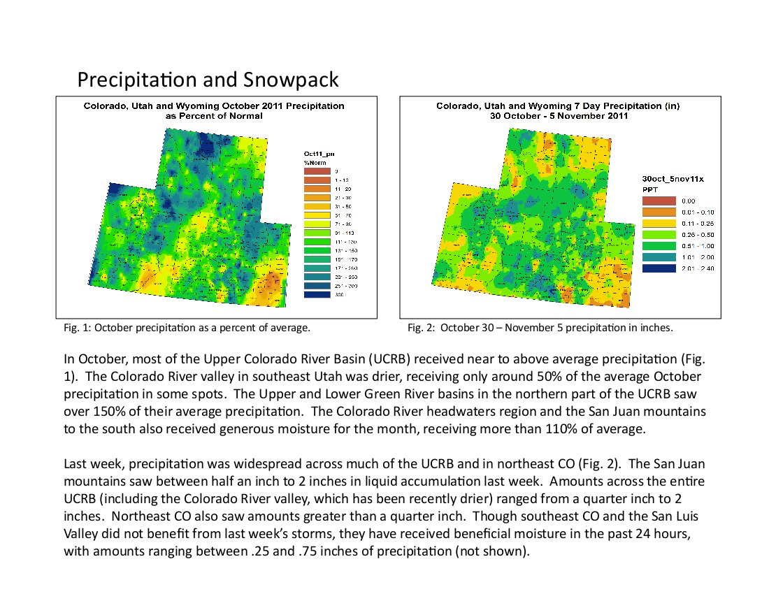
Here’s the release from the Colorado Geological Survey (Vince Matthews):
The Colorado Geological Survey has released three significant new reports on ground water in the Denver Basin. The reports, representing more than a decade of research, provide the most detailed information yet on the varied distribution of groundwater in the Denver Basin and show the most productive aquifers are concentrated near the mountain front and diminish to the east.
All three publications document in different ways that the strata from which many of the people living along the southern Front Range obtain their groundwater, are highly variable. Together, they present a science-based perspective of the complex geometry of the freshwater-bearing strata which resulted from a dynamic geologic history. This new perspective shows a non-uniform distribution of strata with favorable aquifer characteristics across the basin. Because of the way the strata formed, the thickest and most productive sandstones concentrate near the mountain front and diminish to the east.
The reports will help regulators, modelers, consultants, policymakers, and planners better understand the variability of water productivity in the Denver Basin, a major source of water supply for populous regions south of Denver. One of the publications is the result of a collaborative effort with the Denver Museum of Nature & Science (DMNS).
The first report; Geology of Upper Cretaceous, Paleocene and Eocene Strata in the Southwestern Denver Basin, Colorado; is a compilation of more than 1000 square miles of surface mapping of the aquifers where they are exposed along the mountain front. The mapping was originally carried out at a scale of 1:24,000 and is compiled into a 1:50,000 map consisting of two plates. This compilation also presents a simplified naming classification for the geologic strata of the Denver Basin.
The second report; Bedrock Geology, Structure, and Isopach [thickness] Maps of the Upper Cretaceous to Paleogene Strata between Greeley and Colorado Springs, Colorado; takes what was learned by mapping at the surface and extends it into the subsurface using data from nearly 3,000 wells. This report was a collaborative effort with DMNS, whose personnel also spent more than a decade independently working on the strata in the Denver Basin. The report contains seven maps that illustrate the thickness, depth, and distribution of the various freshwater-bearing strata in the Denver Basin. It also contains a depth map to the Niobrara formation, and a thickness map of the Pierre shale that separates the Niobrara from the freshwater aquifers. An additional three maps of ancient landscapes illustrate why the sandstone aquifers are concentrated near the mountain front. Included with this report is an illustrative poster that explains the various environments within which the strata were deposited. The poster is also sold separately.
The third publication; Cross Sections of the Freshwater Bearing Strata of the Denver Basin between Greeley and Colorado Springs, Colorado; contains four north-south, and eleven east-west, detailed cross-sections of the strata in the Denver Basin. These cross- sections integrate surface geologic mapping with subsurface well data to graphically illustrate variability in the types of strata across the entire basin. This report is oriented toward the professional community, rather than the general public.
All three publications come in hard copy and include DVDs with detailed PDFs of the plates and GIS shapefiles containing metadata. The publications can be ordered from the Colorado Geological Survey at 303-866-2611 or in the online bookstore at http://geosurveystore.state.co.us/.
More coverage from Chris Woodka writing for The Pueblo Chieftain. From the article:
A new study by the Colorado Geological Survey and U.S. Geological Survey shows the Denver aquifers are thinner and less tributary than previously thought. At the same time, energy exploration is skyrocketing in the Niobrara formation, which runs through the geologic heart of Colorado. The fastest-growing areas of the state are located over the Denver Basin aquifers and their water supplies tap into what was thought to be a vast supply that would last 100 years into the future.
“This study is alarming because what we believed about aquifers for the last 20, 30, 40 years has been shattered,” state Rep. Marsha Looper, R-Calhan, told the Arkansas Basin Roundtable Wednesday. “The study of the geology showed the reservoirs are not as thick and deep as we thought.”[…]
Looper plans to introduce legislation to study how much water is available in the Denver Basin aquifers, rather than relying on past estimates that now may be inaccurate. “I want to take the Colorado Geological Survey study a step further and study how much water there actually is in the Denver Basin,” Looper said. “I plan to introduce a bill, but I want to work with the roundtable to take a bottoms-up approach to the issue.”
More coverage from Bob Berwyn writing for the Summit County Citizens Voice. From the article:
The reports compile more than a decade of research and provide the most detailed information to-date on the the distribution of groundwater, representing crucial information for water managers and land-use planners in the semi-arid region. Together, they present a science-based perspective of the complex geometry of the freshwater-bearing strata which resulted from a dynamic geologic history.
This new perspective shows a non-uniform distribution of strata with favorable aquifer characteristics across the basin. Because of the way the strata formed, the thickest and most productive sandstones concentrate near the mountain front and diminish to the east.
The reports will help regulators, modelers, consultants, policymakers, and planners better understand the variability of water productivity in the Denver Basin, a major source of water supply for populous regions south of Denver. One of the publications is the result of a collaborative effort with the Denver Museum of Nature & Science.
More Denver Basin Aquifer System coverage here and here.

