Klaus Wolter (Climate Prediction Center) told the CWCB’s Water Availability Task Force yesterday (from my Twitter Feed @coyotegulch), beyond next week — temperatures warm, storm tonight, next weekend and probably one after that. We may exceed normal precipitation.
Here’s a report from Bobby Magill writing for the Fort Collins Coloradoan. From the article:
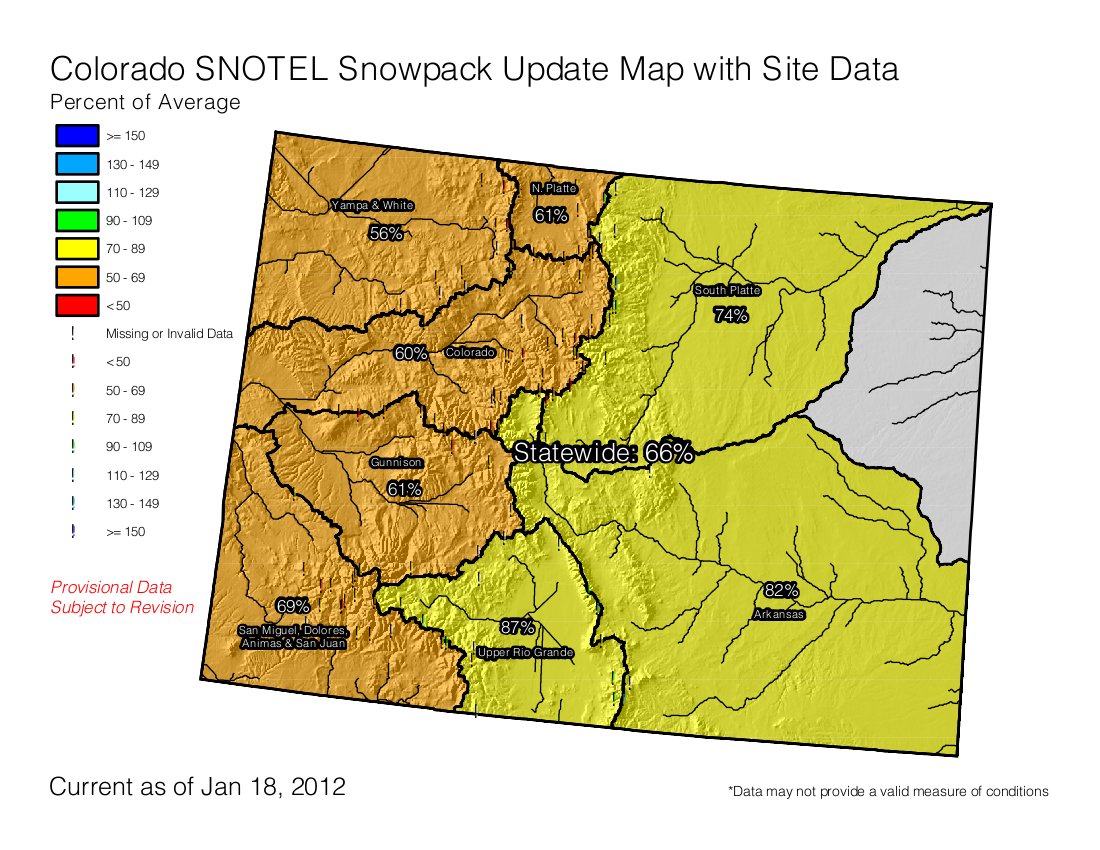
The U.S. Natural Resources Conservation Service reported the water content of the snowpack in the Upper Colorado River Basin was 70 percent of normal Jan. 17, 2002. On the same date this year, the snowpack was worse there: 61 percent of normal.
The Laramie and North Platte river basins had a snowpack 62 percent of normal on that day in 2002. In 2012, the snowpack was exactly the same. In the South Platte Basin, which includes the Poudre River, the snowpack was 54 percent of normal. This year, it was a bit better: 73 percent of normal…
“The sense of optimism we have right now, that is the forecasts are strongly indicating a weather pattern change that’s imminent,” said Colorado State Climatologist Nolan Doesken. The shift already has started as the jet stream is beginning to drop south now that arctic air has moved into the Gulf of Alaska, pushing a hefty dose of snow to the Rockies this weekend, said meteorologist Mark Heuer of DayWeather in Cheyenne, Wyo. “The Rockies are starting to see consistent and heavy snow,” he said…
There’s another big difference between the winter conditions of 2012 and those of 2002. “We’re going in well ahead above average in (water) storage,” said Brian Werner, spokesman for the Northern Colorado Water Conservancy District in Berthoud.
From the Valley Courier (Ruth Heide):
The annual index flow for the Rio Grande is normally about 650,000 acre feet, but the initial projection is for 505,000 acre feet, Hardesty reported. The Conejos River system, which ended the year with more water than expected, is initially forecast to produce 258,000 acre feet or about 90 percent of the average 280,000 acre feet. Both the Rio Grande and Conejos Rivers ended the calendar year with a credit on the Rio Grande Compact, Hardesty added…
Hardesty said although the current basinwide snowpack is 82 percent, “the numbers are all over the place.” The SNOTEL site at Wolf Creek Summit, for example, registered 104 percent of average as of Tuesday, Jan. 17, while the Lily Pond site was only registering 53 percent of average.
From USA Today (Doyle Rice):
“There are quite a few storms lined up over the Pacific that will be coming onshore over the next several days,” Weather Channel meteorologist Frank Giannasca said…
The storm dumped almost a foot of snow on Washington’s capital, Olympia, the National Weather Service reported. That amount was close to the city’s 24-hour record of 14 inches. Seattle saw about 4-6 inches of snow.
Like this:
Like Loading...