
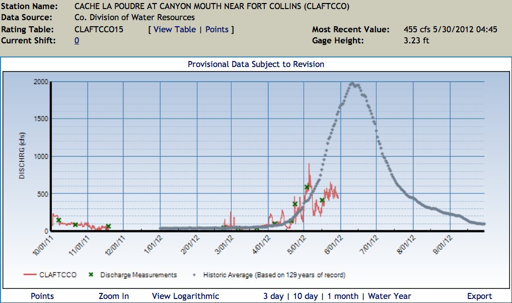
Click on the thumbnail graphic for the water year 2012 hydrograph for the Cache la Poudre River at the mouth of Poudre Canyon from the Colorado Division of Water Resources.
From The Greeley Tribune (Eric Brown):
Streamflow in the Poudre River, which cuts through north Greeley and goes on to serve as the largest tributary stream to the South Platte River, is particularly dismal. According to numbers provided by the Northern Colorado Water Conservancy District, peak stream flow in the Poudre River came earlier and was lower this year than any other year on record — dating back to 1957. Peak streamflows in the South Platte River are not at all-time lows this year — that happened in 1954. But, according to Colorado Water Resources Division 1 Engineer Dave Nettles, the river’s peak flow this month was about three times less than it was in 2002 — the year of a historic drought that changed the way many producers and municipalities manage water…
Mike Hungenberg, a Weld County carrot grower who serves as the board president for the New Cache La Poudre Irrigation and Reservoir Company, said his ditch company this year can serve only half of its shareholders at a time — sending water to one half of its district some days and cutting off supplies to the other half, and then switching. “We’ve never had to do that,” Hungenberg said. “Not even in 2002.”[…]
Snowfall was lacking in the mountains for most of the winter — with snowpack numbers at or near record lows in much of the state — and this year’s abnormally warm temperatures caused what little snowpack there was to melt well ahead of schedule. With peak flows in the Poudre River coming on May 5 this year, that water passed by many farmers before their crops were even planted. To add to it all, rainfall has been minimal — precipitation in the Greeley area this year is less than half of the historic average.