


Click on the thumbnail graphics to the for the March 1, 2012 through June 2, 2012 hydrograph for the Colorado at the Utah state line, the current U.S. Drought Monitor map and the statewide snowpack map from May 31, 2012. Streamflow at the Utah border is well below average and much below water year 2011 near record flows were roaring through Cataract Canyon on the way to Lake Powell.
From email from the Eagle River Water and Sanitation District:
The U.S. Drought Monitor expanded the area in northwest Colorado that is designated as being in extreme drought, growing 3 percent in the last week to cover about ten percent of the state. The May 29 map, released Thursday, shows 100 percent of Colorado is experiencing some level of drought condition.
The extreme drought area abuts Eagle County and includes most of Garfield, Rio Blanco, and Routt counties as well as portions of Moffat, Pitkin, and Mesa counties. Drought intensity in Eagle County is D2, severe, and D3, extreme – just on the western boundary – on a scale of D0 to D4.
The U.S. Drought Monitor is one of several drought monitoring tools produced by the National Drought Mitigation Center that helps people assess drought severity and impacts. Another tool is the Vegetation Drought Response Index that depicts vegetation stress across the contiguous United States. The vegetation condition in Eagle County is described as pre-drought, moderate drought, and severe drought.
Water available for local vegetation could be limited this year. At Wednesday’s Eagle River Valley State of the River meeting, Mage Hultstrand of the Natural Resources Conservation Service said the snow water equivalent for the Eagle River basin on May 30 was just three percent of the historical average. Hultstrand also noted the Vail Mountain SNOTEL (snow telemetry) site melted out completely on April 7, nearly eleven weeks earlier than normal, and said streamflows for the Eagle River below Gypsum are forecasted to be at 43 percent of average.
With our community water supply largely dependent upon adequate flows in local streams and rivers, Eagle River Water and Sanitation District encourages its customers to take action to lessen the impact of drought.
Protect the investment made in landscaping by following best practices that encourage a deep root system, which helps plants get through dry spells. Should drought conditions persist, water available for irrigation and other outdoor uses may be less than normal, or unavailable, this year. Currently, normal year-round Water Use Regulations are in effect. For more information go to http://www.erwsd.org or call ERWSD Customer Service at 970-477-5451.
From the Summit County Citizens Voice (Bob Berwyn):
Eagle and Summit and Grand counties are designated as being in a severe drought, with streamflows forecast to be well below normal across the region. The latest update from the U.S. Drought monitor shows all of Colorado now experiencing some level of drought, with Eagle County, for example, experiencing pre-drought, moderate drought and severe drought conditions, depending on the exact location…
Lake Powell, the key reservoir on the Colorado River system, is at 79 percent of average and only about two-thirds full. Daily inflows are well below average for this time of year. [ed. At last week’s NIDIS webinar a participant said that inflows to Lake Powell in May 2011 were a million acre-feet, this year 54,000 acre-feet.] For the next week, dry conditions are expected to continue under a strong ridge of high pressure, with precipitation confined to the highest terrain of Colorado. There’s a chance of significant precipitation at the western edge of the Upper Colorado River Basin during the coming week, as a Pacific trough approaches the region.
From Steamboat Today (Matt Stensland):
A weekly report updated by the U.S. Department of Agriculture on Thursday indicates extreme drought conditions continue to expand in Northwest Colorado. “And they’re expected to get worse,” said Joe Ramey, a meteorologist with the National Weather Service in Grand Junction. “We have just been spiraling into more and more severe drought, and that has not changed this week.”
The Drought Monitor shows that nearly all of Northwest Colorado is experiencing at least a severe drought, and much of the area is seeing extreme drought conditions. Ramey said the Drought Monitor is based mostly on past precipitation as well as soil moisture levels…
According to Steamboat Springs weather observer Art Judson, 0.68 inches of precipitation fell in May compared to an average of 2.08 inches.
From the Loveland Reporter-Herald:
The City of Loveland is partnering with the Center for ReSource Conservation to offer free sprinkler audits to Loveland residential water customers. Slow the Flow is a free sprinkler inspection program designed to optimize sprinkler operations and be efficient with outdoor water use. This free pilot program enables Loveland customers to have their automatic, underground sprinkler systems inspected by trained water auditors who inspect for performance and efficiency. After the inspection, residents will receive a customized watering schedule and tips for easy do-it-yourself sprinkler maintenance. Inspections are available June 1 through Aug. 31 while supplies last.
From the Boulder Daily Camera (Joe Rubino):
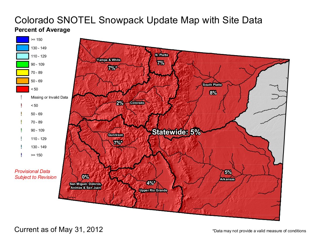
Boulder received just 3.01 inches of precipitation over the three-month period, meteorologist Matt Kelsch said, making it the driest spring — as he defines the season for weather purposes — since the city began keeping records in 1894. The average amount of precipitation Boulder receives in March, April and May is 7.85 inches, Kelsch said. Snowpack levels statewide are about 5 percent of average for this time of year, according to the Natural Resources Conservation Service. “It was a dismally dry spring,” Kelsch said…
Klaus Wolter, a climatologist for the National Oceanic and Atmospheric Administration in Boulder, called this spring “miserable” but noted it could have been worse. February was the snowiest in Boulder’s records, according to Kelsch, and May’s weather conditions were not particularly far off averages for the month. As recently as early May, Wolter said he was optimistic that an El Nino pattern would form, bringing more moisture to Colorado in the coming fall. Now, he said, he is concerned Colorado may be facing a third straight La Nina year, though he is at least a few months away from being able to say if that outcome is likely. “My concern is not so much with the summer,” Wolter said. “If we were to go back into a third-year La Nina … that would be a big worry. That’s how we got into a big drought in the early 2000s.”