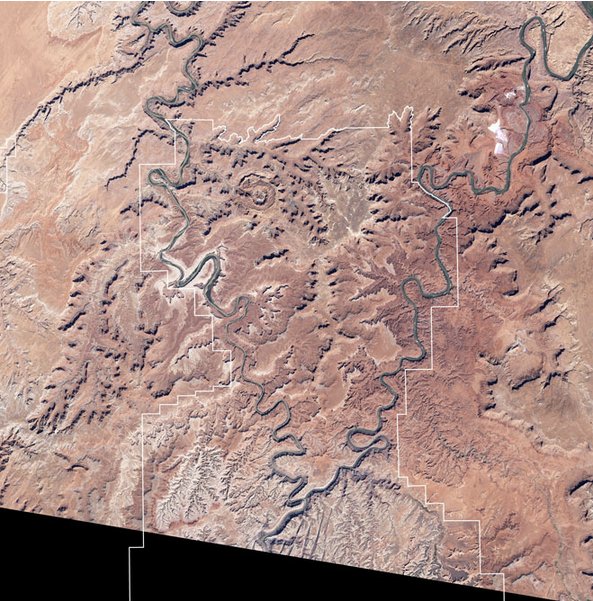
Click here to go to Wired’s photo essay of select National Parks from space. Here’s the link to the Canyonlands National Park website.
Thanks to @NewMexiKen for the link.

Click here to go to Wired’s photo essay of select National Parks from space. Here’s the link to the Canyonlands National Park website.
Thanks to @NewMexiKen for the link.

Here’s the link to the webinar summaries from the Colorado Climate Center.
Click on the thumbnail graphic for the precipitation summary.

From the release from Colorado Bar Association CLE (Dawn McKnight):
On June 18, author, scholar, and Colorado Supreme Court Justice Greg Hobbs will present on two of his books: Living the Four Corners: Colorado, Centennial State at the Headwaters, published in 2011, and his new book Into the Grand. The presentation will include a special introduction by Patty Limerick, Faculty Director and Chair of the Board of the Center of the American West at the University of Colorado.
The event is not only available to attend in person, but also via live webcast from your computer. You’re able to see the live event even if you’re not in the Denver area!
Colorado Supreme Court Justice Greg Hobbs’ Living the Four Corners: Colorado, Centennial State at the Headwaters was a finalist in 2011 in the Colorado Authors’ League General Nonfiction category and is published by Colorado Bar Association Continuing Legal Education. Hobbs says, “Culture of the Four Corners to me is the culture of the Americas. This book takes a look at the landscape and the culture and the spirituality and the legal arrangements that made the Four Corners part of United States. I hope it reflects, in a very positive way, our legal profession and its commitment to community.” Justice Hobbs says about this latest book Into the Grand, “I like writing, reading the writing of others, and traveling through the imaginative landscape of this great country with family, friends, maps and guides we meet along the way . . . The poems and prose poems are way markers and cairns.”
EVENT DETAILS:
June 18, 2012 – 4 – 6 p.m.
Colorado Bar Association CLE – 1900 Grant St, Ste 300, Denver, CO 80203
This program is complimentary and refreshments will be served
RSVP: Call Melissa Lucas at 303.824.5387 or mlucas@cobar.org.Please indicate whether you plan to attend either live or by live webcast and the relevant information will be emailed to you.
More Colorado Water 2012 coverage here.
Here’s a guest column written by Wyco Water and Power, Director of Business Development, Nathaniel Budd, running in the Fort Collins Coloradoan. From the column:
Colorado has water available under the Colorado River Compact, a 1922 agreement among seven Colorado River basin states governing allocation of water rights for the Colorado River. Until Colorado’s apportionment is fully developed, the Lower Basin (California, Nevada, and Arizona) will benefit at the detriment of Colorado. For 90 years, our region has over-delivered to the Lower Basin, largely because the infrastructure does not exist to utilize the water supply available to this state. The water belongs to Colorado, not California…
Rather than develop waters allocated for the state’s beneficial use nearly 100 years ago, opponents of the Regional Watershed Supply Project would prefer to stunt economic growth and endanger the Upper Basin’s future water supply. If Colorado’s forefathers had been of this mindset, the eastern slope communities and the multi-billion-dollar agricultural base that supplies open spaces, preserves western culture, and provides innumerable environmental benefits would not exist as we know them today.
Meanwhile, here’s a report about FERC’s latest rejection of the pipeline’s preliminary permit, from Mary Bernard writing for the Vernal Express. From the article:
Aaron Milllion’s hydropower and water supply project, renamed the Wyco Power and Water Project was denied by the Federal Energy Regulatory Commission on May 17. That’s the second refusal of the project’s preliminary permit request from FERC, preceded by the U.S. Army Corps of Engineers’ termination in 2011. FERC refused a rehearing on the decision saying, Million’s arguments were unsupported and no preliminary permit for its proposed Regional Watershed Supply Project would be issued…
The project has received widespread resistance from the private sector throughout the tri-state area. Formal opposition from Daggett and Uintah Counties, the Wyoming communities of Green River and Rock Springs, Sweetwater County, Wyo. and Moffatt County, Colo.
Local fly fishermen openly opposed the water project saying it would draw down reservoirs and destroy world class fisheries on the Green River and Flaming Gorge. High Desert Anglers president Jeff Taniguchi warned that the “Million Project would absolutely decimate one of the most beautiful places in Utah, and compromise every downstream user of water on the Green.”
Western Resource Advocates filed objections representing itself, the National Parks Conservation Association and the Colorado Environmental Coalition.

From The Greeley Tribune (Eric Brown) via Windsor Now!:
…with the rapid growth along the Front Range, which has put pressure on water supplies and made water more expensive, [Charles Tucker] and others question — even worry — whether there is enough water today to accommodate an additional 50,000-plus dairy cows. Each cow can consume 50-plus gallons of water per day, but they are needed to meet the milk demands of Greeley’s new and expanding Leprino cheese plant. Those concerned also wonder — if the water is there for the dairy growth — will dairymen have to pay so much for it that it prevents them from making a profit?[…]
In response to such concerns, developers and others at the forefront of the region’s dairy-expansion efforts say the water for dairy expansions is available. And although it is very pricey, dairies under good management can still make money, they said.
The dairy growth in the area is a gradual process, expected to continue during the next few years. Seven to eight new dairies in Weld County — most of which will be owned by producers coming from California — are expected to be producing milk by some time next year, with two of them possibly operating by the end of 2012, according to Wade Meek with Dairy Farmers of America and others in the dairy industry. Because of that, Leprino officials say the growth of the region’s dairy industry is on pace to meet their demands through at least next year, when the plant will be taking in about 3.5 million pounds of milk per day, more than twice as much as it is now.
Tom Haren, owner of AgProfessionals in Longmont, which is a development company that has helped producers find locations for new dairies or expansions, said that, so far, the new dairies have been going up on sites of previous agriculture operations — old feedlots and dairies, former Butterball turkey farms and others — where water supplies already existed and have been sitting idle. “At a lot of these sites, we’re not having to go out and get new water,” said Haren.
More South Platte River basin coverage here.

Here’s the link to the report (registration required). Here’s the release from Ceres:
Citing technological uncertainties and a wide range of other risks, a new Ceres white paper supports a federal agency’s proposal to take a cautious approach to oil shale production in the western U.S.
At issue is the Bureau of Land Management’s proposal to focus oil shale production in Wyoming, Utah and Colorado on “Research, Development, and Demonstration” (RD&D) leases only and to reduce the available acreage to about 500,000 acres from nearly two million acres under an earlier plan.
“Given the wide array of uncertainties, BLM’s proposed leasing approach on oil shale makes sense,” said Ceres president Mindy Lubber, citing regulatory risks, water constraints and numerous other questions about various technologies being pursued to extract a non-liquid form of oil from shale rock. “Investors should be similarly cautious in evaluating future investment in this space.”
“Oil shale technologies are still highly speculative, and proving them to be commercially viable will be difficult and require a long period of time with uncertain outcomes,” said Paul Bugala, senior sustainability analyst, extractive industries, at Calvert Investments. “The little that state and federal regulators know about the environmental impacts, especially in the areas of water use and land reclamation, further indicates that caution should be exercised.”
While oil shale reserves beneath the three states in the Green River Formation are vast, holding more than three times the proven reserves of Saudi Arabia, the Ceres white paper, Investor Risks from Oil Shale Development, sends a strong cautionary message to policymakers, investors and companies alike.
The white paper, prepared by David Gardiner & Associates, LLC, identifies five key risks to oil shale development:
Core technological uncertainty: Despite decades of efforts, surface and in-ground technologies for producing oil shale still face many uncertainties. The report states: “The uncertainties around continued testing and development of new technologies and processes for producing oil from oil shale leave a great deal still unknown, including the amount of the resource that is recoverable, the efficiencies and costs of various methods, the impacts on natural resources, and the effects of various technologies on the costs of final products (and thus the competitiveness of oil shale).” The white paper cites an earlier report by the Task Force on Strategic Unconventional Fuels (comprised of federal, state, and local officials) which states: “[t]echnology uncertainty is the largest single risk factor associated with oil shale development. This uncertainty remains even after 50 years of government and industry research to develop a commercially viable retorting technology.”
Market risks: Production of oil shale is characterized by significant capital investment, high operating costs, and long payback periods – at least a decade. Uncertainties about the costs associated with developing a first-generation commercial facility, combined with oil price volatility and other uncertainties, pose investment risks that make oil shale investment less attractive than other potential uses of capital. Sporadic attempts to commercialize oil shale have repeatedly failed once oil prices fall.
Water constraints: Oil shale development’s need for water is a particular concern in water-stressed states such as Colorado and Utah. The report cites estimates showing that surface technologies may require 2 to 4 barrels of water for every barrel of product produced while in-ground technologies may require up to 12 barrels of water per barrel produced. The U.S. Government Accountability Office has suggested that the size of the oil shale industry in Colorado and Utah may be limited by water availability.
Regulatory risks: Lifecycle carbon emissions for oil shale fuels are likely to be 25 to 75 percent greater than for conventional petroleum. This means oil shale development could face risks as carbon-reducing rules and regulations take hold – whether low-carbon fuel standards, a price on carbon emissions, lifecycle emissions requirements, or other measures. Other federal and state environmental regulations, including those related to air and water quality, also pose risks to oil shale development.
Risks from public opposition: Public opposition to oil shale based on the actual or perceived environmental impacts could “derail, delay, or increase the costs of such projects,” says the white paper.
More than 70 percent of the Green River Formation oil shale resources lie beneath federal lands. BLM is presently considering public comments on its proposal to limit development to RD&D leases on 252,181 acres in Utah, 174,476 acres in Wyoming and 35,308 acres in Colorado. A decision is expected in fall 2012.
From the Ceres website:
Ceres is an advocate for sustainability leadership. Ceres mobilizes a powerful coalition of investors, companies and public interest groups to accelerate and expand the adoption of sustainable business practices and solutions to build a healthy global economy. Ceres also directs the Investor Network on Climate Risk (INCR), a network of 100 institutional investors with collective assets totaling more than $10 trillion.
Here’s the latest installment of the Valley Courier’s Water 2012 series. Nathan Coombs, manager of the Conejos Water Conservancy District, has written a primer about water and agriculture. Here’s and excerpt:
1) Priority- like it implies, there are certain users of water that get priority over others. This priority system is based on “first come, first served.” The earlier in history that someone put water to a good (beneficial) use, the lower their priority number. This number however, is like the placing in a tournament- #1 is best or senior and so on. A water right can however be both senior and junior. For example the #2 priority is senior to the #3, yet junior to #1. The actual physical location along the river is basically irrelevant. The priority number determines who gets the water in what order.
2) Decree- this term is used to define how much water, and to what purposes the water is used. For example, you cannot use water for raising fish unless this purpose is expressly granted in your decree. You also cannot take from the source (well or river) all that you want. Your decree states how much water to which you are entitled. The term decree is applicable to both river (surface) water and well (ground) water.
3) Compact- this is a legal term for a federally recognized interstate or international agreement. The Rio Grande River Compact dictates how water from the Rio Grande River is divided between Colorado, New Mexico, Texas, and Mexico. It was developed to be as equal and fair as possible. (This topic is always up for coffee shop discussion!)
4) Unconfined aquifer- this is the area of water that exists from immediately below the surface of the ground to a depth that varies from about 75 to 200 ft. At the bottom of this “layer” is a boundary of clays and Malpais lava flows that really slows water from moving up or down.
5) Confined aquifer- this is the area that is below the unconfined. Where the unconfined is relatively shallow, the confined can be thousands of feet deep. This is where artesian water comes from because of usual upward pressure.
6) Diversion- Diversion describes the location and method used to get water from a river or the ground. A headgate on the river is a diversion for surface water and a well is the diversion for the ground water.
More Colorado Water 2012 coverage here.

From FoxNews.com (Kelly David Burke):
…according to Colorado State Climatologist Nolan Doesken. “Yet we’re [Fort Collins] one of the wetter areas of the West. Other areas may only be looking at 6 to 10 inches of precipitation a year.”
“From a Western perspective the rain that falls on your head barely waters anything. The snow that falls most winters, somewhat generously, in the mountains and then melts during the spring and summer is the water supply for most agricultural and municipal uses.”[…]
Kathleen Sgamma of the Western Energy Alliance believes fears about fracking using too much water are overblown. She points to a recent study by the Colorado Division of Water Resources that showed that in 2010, 85 percent of the water used in Colorado went to agriculture, 7.4 percent to municipalities and less than 1 percent to hydraulic fracturing. “It’s certainly an issue that we take very seriously,” Sgamma says. “But when you consider the jobs and the economic impact that you get from oil and gas and you compare that to the water usage, it’s a pretty small usage for that economic impact.”[…]
“There are seven to nine layers of steel and cement between the well bore and any underground aquifer. There are several layers of protection to make sure that (underground) water cannot go into the well, and oil or gas cannot get into the aquifer.”
Meanwhile, the Department of Interior is moving ahead with disclosure rules for hydraulic fracturing, according to Gus Jarvis writing for The Telluride Watch. From the article:
While there are 35 states with some form of fracking regulations (Colorado included), there is currently no federal requirement for oil and gas companies to disclose chemicals on federal lands where approximately 90 percent of natural gas wells are drilled. Current Bureau of Land Management regulations governing fracking are more than 30 years old and are not written to address modern fracking practices.
The proposed rule, according to information provided by the Department of Interior, seeks to maximize flexibility, minimize duplication and complement ongoing efforts in some states to regulate fracturing activities by providing a consistent standard across all federal and Indian lands, and make reported information easily accessible to the public through the existing program known as FracFocus.
Besides requiring the disclosure of chemicals used in fracking, the draft rule contains two additional measures to improve assurances on well-bore integrity – to verify that fluids used in wells during fracking operations are not escaping – and to confirm that oil and gas companies have a water management plan in place for handling fracking fluids that flow back to the surface.
According to Secretary of the Interior Ken Salazar, the proposed rule will strengthen the requirements for hydraulic fracturing performed on federal and Indian lands in order to build public confidence and protect the health of American communities, while ensuring continued access to the important resources that make up our energy economy…
In Colorado, a similar rule took effect April 1. Gov. John Hickenlooper applauded this latest move by the Department of Interior. “We are pleased that the Bureau of Land Management modeled its disclosure requirements for fracturing fluids after the Colorado rule, which is the most protective and transparent in the country as it requires the disclosure of the chemicals as well as their purpose and concentrations,” Hickenlooper said.
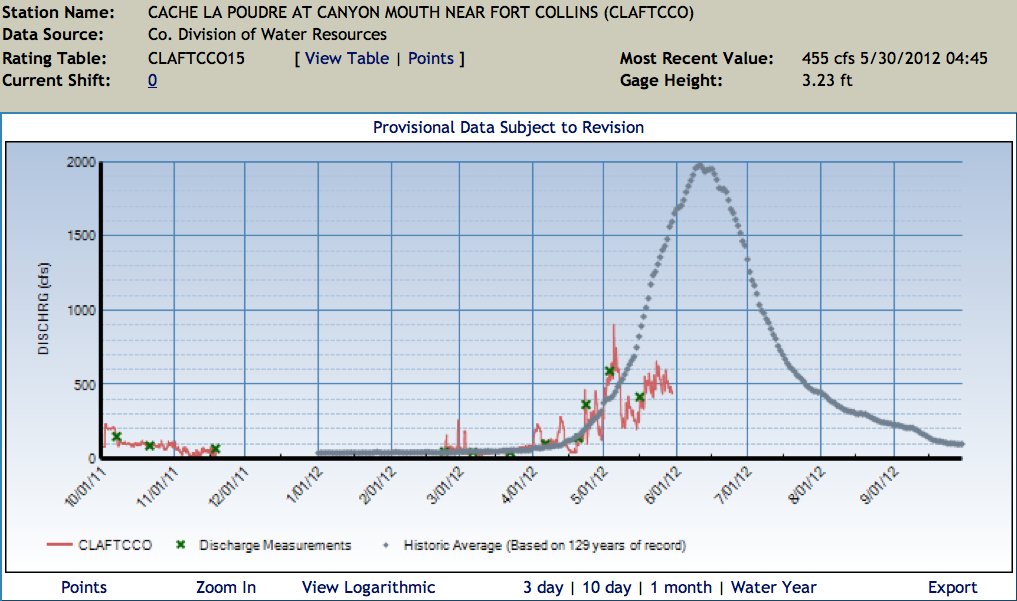
Click on the thumbnail graphic for the water year 2012 hydrograph for the Cache la Poudre River at the mouth of Poudre Canyon from the Colorado Division of Water Resources.
From The Greeley Tribune (Eric Brown):
Streamflow in the Poudre River, which cuts through north Greeley and goes on to serve as the largest tributary stream to the South Platte River, is particularly dismal. According to numbers provided by the Northern Colorado Water Conservancy District, peak stream flow in the Poudre River came earlier and was lower this year than any other year on record — dating back to 1957. Peak streamflows in the South Platte River are not at all-time lows this year — that happened in 1954. But, according to Colorado Water Resources Division 1 Engineer Dave Nettles, the river’s peak flow this month was about three times less than it was in 2002 — the year of a historic drought that changed the way many producers and municipalities manage water…
Mike Hungenberg, a Weld County carrot grower who serves as the board president for the New Cache La Poudre Irrigation and Reservoir Company, said his ditch company this year can serve only half of its shareholders at a time — sending water to one half of its district some days and cutting off supplies to the other half, and then switching. “We’ve never had to do that,” Hungenberg said. “Not even in 2002.”[…]
Snowfall was lacking in the mountains for most of the winter — with snowpack numbers at or near record lows in much of the state — and this year’s abnormally warm temperatures caused what little snowpack there was to melt well ahead of schedule. With peak flows in the Poudre River coming on May 5 this year, that water passed by many farmers before their crops were even planted. To add to it all, rainfall has been minimal — precipitation in the Greeley area this year is less than half of the historic average.

From the Colorado Springs Independent (Pam Zubeck):
Colorado Springs Utilities isn’t alone in thinking Pueblo County District Judge Victor Reyes made a mistake.
The Colorado Water Quality Control Commission has voted unanimously to stand with Utilities in opposing Reyes’ decision to overturn the state’s 401 water quality certification for the Southern Delivery System. Reyes had ruled the state commission didn’t adequately account for Fountain Creek pollution caused by the SDS pipeline, which will increase Colorado Springs’ water supply by a third by 2016 by delivering water from Lake Pueblo. After certification in 2010, the Rocky Mountain Environmental Labor Coalition and Pueblo County District Attorney Bill Thiebaut sought judicial review, resulting in Reyes’ ruling.
State Commissioner John Klomp, a former Pueblo County commissioner, made the motion to appeal the ruling, noting that sufficient controls are in place and that Colorado Springs complies with the rules, the Pueblo Chieftain reports. Utilities spokesperson Janet Rummel says SDS construction continues.

Here’s a look at the motivation to conserve water — primarily financial — from Colleen O’Connor writing for The Denver Post. From the article:
That year [2002] was brutal. People tried to conserve water. They turned off backyard fountains and let their ponds dry up. But it wasn’t until the recession that began in December 2007 that there was a real shift in the way people approached their landscapes…
“But that was short-lived. It lasted about a year. We kept having the same education with the public and clients, but nobody paid any mind to it until about a year ago.” Suddenly, new irrigation technologies became popular. “People were trying to save money because of the recession,” Scott Huston said. “Wealthy people on big estates were tired of paying the water bill.”[…]
In January, Gov. John Hickenlooper proclaimed 2012 the Year of Water, and communities across the state are hosting activities from Xeriscape garden tours and classes in Pueblo and Aurora to the “H2012” exhibition in the Art District on Santa Fe through June 30…
Phil Steinhauer, president of Designscapes Colorado, has noticed a shift in things such as size and function. “I remember 10 years ago, everyone wanted lots of grass,” he said. “I very rarely hear anyone say that now. They want a nice, usable yard, with a nice patio and maybe a firepit.”
More conservation coverage here.
![]()
Here’s the release from the U.S. Bureau of Reclamation (Justyn Hock):
Today, Secretary of the Interior Ken Salazar highlighted nine of 51 total projects, one in each state and the District of Columbia, that serve as models of the America’s Great Outdoors River Initiative to conserve and restore key rivers across the nation, expand outdoor recreational opportunities and support jobs in local communities.
Included in this list is the San Juan River in Reclamation’s Upper Colorado Region.“The San Juan River Habitat Restoration Project, as part of America’s Great Outdoors Rivers Initiative, will greatly assist Reclamation and all of its federal, tribal, states and non-governmental partners in the San Juan River Basin to continue the significant gains being made towards eventual recovery of endangered species of fish,” said Western Colorado Area Manager Ed Warner.
The goals of the Rivers Initiative include protecting and restoring America’s rivers for people and wildlife and enhancing river recreation that support jobs in tourism and outdoor recreation.
Of the 51 projects, nearly half expand recreational fishing and boating while others improve signage, maps, access points and other tools to enhance recreational use of rivers. Twelve projects engage youth in projects while 12 projects also support the America’s Great Outdoors Urban Initiative, to enhance parks and other outdoor recreational facilities and provide outdoor education to young people in cities.
“Across the country, we are working hand in hand with states, tribes, local communities and other partners to revitalize our nation’s rivers and expand the opportunities for people to fish, boat, and otherwise connect with the natural world,” Salazar said. “These on-going projects demonstrate how the federal government can be an effective conservation partner for community-led efforts to improve our environment and the quality of life of residents while creating jobs in the outdoor recreation economy.”
Reclamation will serve as lead on four of these projects: the Red Bluff Fish Passage Improvement Project on the Sacramento River in California; the Yankee Fork (of the Salmon River) Off-Channel Habitat Restoration in Idaho; the Colorado River Heritage Greenway Park and Trails in Nevada and the San Juan River Habitat Restoration in New Mexico. Reclamation will co-lead a project in Nebraska with the U.S. Fish and Wildlife Service: Platte River Restoration and Recreation Project.
Salazar unveiled the America’s Great Outdoors Rivers Initiative in January as part of President Obama’s overall America’s Great Outdoors initiative to work with communities across the country to establish a 21st century conservation ethic, reconnect people, especially young people, to the natural world, and promote the outdoor recreation economy.
Here’s the project description from the Department of Interior website:
The San Juan River is home to the endangered Colorado Pikeminnow and Razorback sucker. The San Juan Recovery Program assists in recovery of endangered species for over 300 water development projects in Utah, Colorado, and New Mexico. In addition, actions taken under this program will provide benefits to other native fishes in the San Juan Basin and prevent them from becoming endangered in the future.
Recovery actions involve restoring and managing stream flows and habitat, boosting wild populations with hatchery-raised endangered fish, and reducing negative interactions with non-native fish species. For this project, bulldozers and excavators were used to construct secondary channels and backwaters and remove non-native vegetation.
While species recovery and water development are the primary benefits of these recovery activities, in-stream flow protection and habitat restoration will also likely result in healthier riverine and riparian environments in national parks, on tribal lands, and on other public and private lands enjoyed by outdoor recreationists and nature enthusiasts.
More San Juan River Basin coverage here.

Here’s the release from the Eagle River Water & Sanitation District (Diane Johnson):
for water management in the Eagle River Valley – a place where life is sustained by the Eagle River and its tributaries.
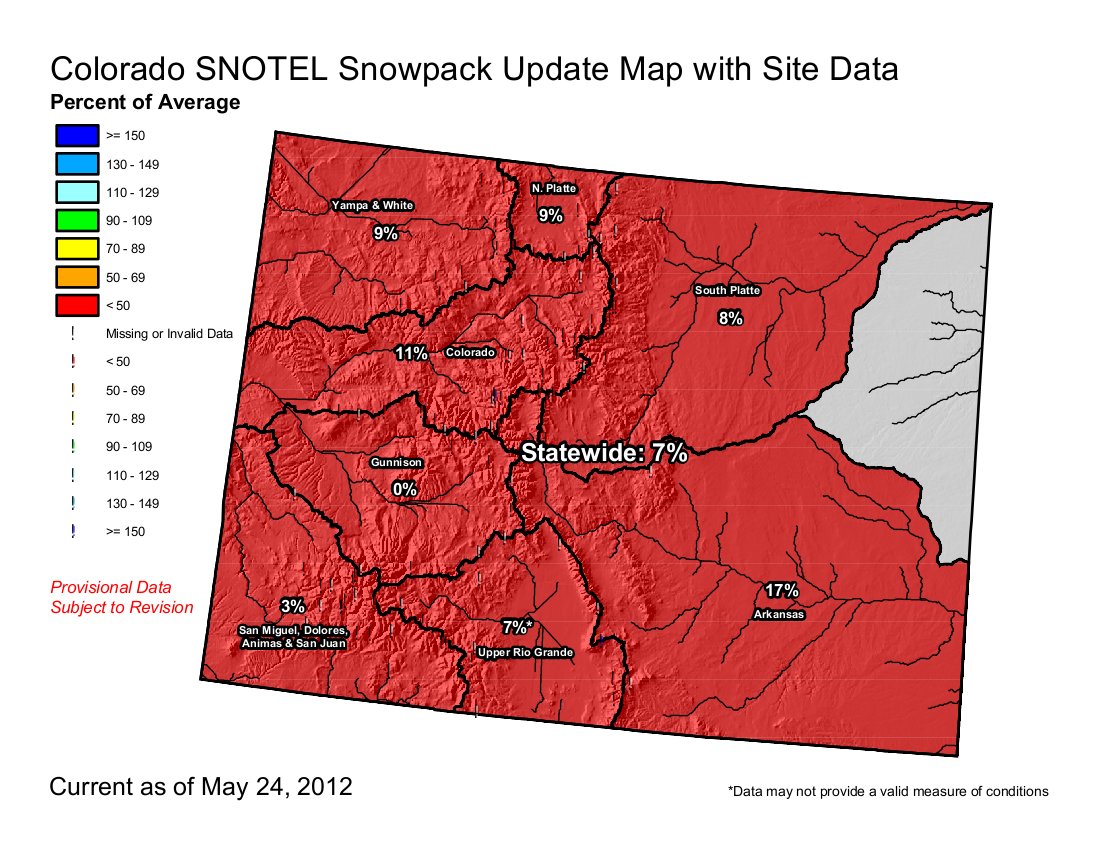
The National Integrated Drought Information System has declared a severe drought in Eagle County and an extreme drought in part of the Colorado River Basin. As of May 24, snowpack levels in the basin stood at 11 percent of average.
The public can learn more about current drought conditions, water supply, and streamflow forecasts at the annual Eagle River Valley State of the River public meeting set for 5:30-8 p.m. May 30 at the Berry Creek Middle School auditorium in Edwards. The event is free and is hosted by the Eagle River Water & Sanitation District, the Colorado River District, and the Eagle River Watershed Council.
The event begins at 5:30 p.m. with a casual reception with light dinner snacks and soft drinks. The evening program begins at 6 p.m. with Mage Hultstrand from the Natural Resources Conservation Service presenting about this winter’s record low snowpack, current river conditions, and streamflow forecasts.
John Mark Seelig with Lakota Guides, John Packer with Fly Fishing Outfitters, and Linn Brooks with Eagle River Water and Sanitation District will discuss plans to mitigate drought impacts locally from a rafting, fishing, and public water system provider perspective. Kendall Bakich with Colorado Parks and Wildlife will address the possibility of voluntary fishing closures being instituted locally.
The meeting also will celebrate the 75th anniversary of the Colorado River District, which was formed in 1937 to protect Western Colorado water against diversions across the mountains to the Front Range. Chris Treese will talk about the Colorado River District’s 75-year history, the statewide Water 2012 celebration, and update the public on the Colorado River Cooperative Agreement, which was signed in February by Eagle River Water & Sanitation District, Upper Eagle Regional Water Authority, Eagle Park Reservoir Company, and Eagle County.
The program concludes with an update on Eagle River Valley waterways – Gore Creek, Eagle River, and the Colorado River. Brooks, Melissa Macdonald with Eagle River Watershed Council, and Eagle County Commissioner Jon Stavney will participate in a panel discussion about recent and planned initiatives that aim to improve water quality and stream health in the Eagle River Valley.
For more information, contact Eagle River Water & Sanitation District at 970-477-5457 or the Eagle River Watershed Council at 970-827-5406.
More Eagle River watershed coverage here.

From the Associated Press (Thomas Peipert) via The Denver Post:
The first impact has been an early paddling season and lower flowing rivers. “We really live on snowpack. That’s what it comes down to,” said Richard Ferguson, a trip coordinator for the Poudre Paddlers Canoe and Kayak Club, which serves northern Colorado.
He said low river flows already have forced him to cancel one trip scheduled in July on the Yampa River. A group outing that had been planned for Memorial Day had to be moved. “A light snowpack means that the peak is very early,” Ferguson said. “What happens is the season just disappears very quickly. What you have, essentially, is no water to paddle in.”
Although he still plans to hit the rapids just about every other week for the time being, Ferguson predicts there won’t be any paddling on the Poudre River by midsummer…
Mage Skordahl, the NRCS’s assistant snow survey supervisor, said the snowpack peaked around March 12, a month ahead of average, and current conditions match those recorded during the record-setting drought of 2002, one of the toughest years for river guides in the state…
Jon Donaldson, co-owner of River Runners, a rafting guide company based in Buena Vista, said, “We’re going ahead full bore like there won’t be an effect.” High water last season — especially in the Royal Gorge area near Cañon City — closed parts of the popular Arkansas River because they were too dangerous to navigate. Donaldson predicts those same sections will remain open the entire season this year, which means the possibility of more trips — and more business.
From the Aspen Daily News (Dorothy Atkins):
Local fishing outfitters are counting on an active monsoon season and a surplus of water from Ruedi Reservoir to keep the stock healthy. [Jarrod Hollinger, owner of the fly-fishing guide company, Aspen Outfitting Co.] is advising locals to follow fishing protocol to protect the stock. Use rubber nets, barbless hooks and be sure to only have fish out of the water for under 30 seconds, said Hollinger…
Low-water levels are going to be a boon for the recreational fishing industry in June and July when the river usually peaks. During those months, high-stream flows typically push fishermen upstream where the flows aren’t as powerful. At lower stream flow levels, there are more options available to fishermen, and tourists opt to fish rather than raft.
From the Delta County Independent (Hank Lohmeyer):
As of [Orchard City trustee Jimmie Boyd’s] report last week, Little Gem and Park reservoirs were full and spilling, and most Grand Mesa reservoirs still had ice cover. The town is expected to have 160 to 170 acre-feet of reservoir water available. Orchard City’s water utility used 120 to 125 acre-feet in 2002, Boyd said. That will leave some 40 acre-feet for the town to rent to valley irrigators.
From the Colorado River District via the Delta County Independent:
However, unlike 2012, Colorado reservoirs this year are relatively in good shape, although Green Mountain, Ruedi, Taylor Park, and Aspinall Unit reservoirs on the Western Slope stand a good chance of not filling.
Those assessments of the state of water reserves was delivered to the Colorado River District board of directors meeting in April.
The report included the following points:
• Wolford Mountain Reservoir has already filled.
• The net effect is that water storage in 2012 puts water users in a better position than 2002, although supplies will have to be closely gauged and steps taken to mitigate anticipated shortages.
• Entities holding contracts in Ruedi Reservoir will be receiving a letter asking if they have excess water to pledge in a pool for use by irrigators if needed this year.
• The Colorado River District itself will be dedicating water it holds in Ruedi, as well as supplies in Wolford Mountain Reservoir to the pool.

From The Pueblo Chieftain (Chris Woodka):
The Southeastern Colorado Water Conservancy District is operating its exchange right to move some of the water in Lake Pueblo up to Turquoise and Twin Lakes in order to boost flows through the summer. “To my knowledge, this is the first time the exchange has been used, since it’s a fairly junior water right,” said Jim Broderick, the district. Rafting companies are encouraged by the move, hoping it will keep flows stable in the river stable during July and early August…
The upper reservoirs in Lake County were drawn down during winter months with the expectation downriver in the spring. Colorado Parks and Wildlife will provide about 900 acre-feet of water to cover evaporation and transit loss, said Division Engineer Steve Witte. Water will be released at key times during the summer in blocks up to 100 cubic feet per second, Witte said.
Meanwhile, here’s a profile of three Southeastern board members with family roots on the board, from Chris Woodka writing for The Pueblo Chieftain. From the article:
…three members of the Southeastern Colorado Water Conservancy District are following in their father’s footsteps more than 50 years after the district was formed.
“People think I have the same knowledge about water as my father, but there’s no way I could ever start to wear his boots,” said Tom Goodwin, choking with emotion. Goodwin also is on the board of the Upper Arkansas Water Conservancy District, which his father, Denzel Goodwin, helped launch in 1979. Denzel Goodwin, who died last year, was a firebrand for Fremont County cattle and water issues from the 1950s, and Tom says he would come home from every meeting and discuss everything with his wife, Marcheta…
Two of Goodwin’s peers now on the Southeastern board also had fathers on the board: David Simpson, whose father, Lee Simpson, served from 1981-2009; and Ann Nichols, whose father, Sid Nichols, was a charter member from 1958 until his death in 1973…
[Nichols] also followed in her father’s footsteps professionally, working in the financial end of the water business for Colorado Springs during the purchase of Foxley Farms assets in Crowley County. She retired after working for 25 years as finance director for Colorado Springs. Now a financial consultant, she is treasurer of the Southeastern board and a member of the Colorado Water Resources and Power Development Authority board…
Simpson learned water working side-by-side with his father for 37 years in forming and running the St. Charles Mesa Water District east of Pueblo. When his father retired in 1999, Simpson became manager of the district.
More Southeastern Colorado Water Conservancy District coverage here.

Here’s the link to H.R. 3680: Hydropower Regulatory Efficiency Act of 2012. Click here to watch the archived webcast of recent hearings by the Subcommittee of the House Energy and Commerce Committee.
Here’s a report about the hearings from Samantha Wright writing for the Telluride Daily Planet. From the article:
HR 3680 passed the House Energy and Commerce Committee with bipartisan support about two weeks ago, but its ultimate fate is still unclear. Companion legislation passed the Senate Energy and Natural Resources Committee in April 2011. If it becomes law, the bill could have a huge positive impact on exactly the kinds of projects that are Kurt Johnson’s bread and butter. Johnson is the President of the Colorado Small Hydro Association (COSHA) and principal at Telluride Energy, a small hydro development and consulting firm. Most of his clients simply seek to take advantage of existing infrastructure, including dams, pipelines and irrigation canals, to create a small steady stream of green electricity.
Johnson recently traveled to Washington DC to testify on the bill’s behalf. As the nation embarks on an “all-of the-above” domestic energy strategy, Johnson told legislators, “We need to dramatically step up the pace of utilizing the massive, currently-untapped resource of small hydro.
“The problem is, the FERC process is particularly burdensome for very small projects, where the cost of FERC compliance can potentially exceed the cost of hydro equipment,” he testified. “Many projects do not get built once people understand the law.” Or, they get built under the radar – in what Johnson calls “guerrilla hydro.”
More coverage from Michael Harris writing for RenewableEnergy.com. From the article:
The bipartisan bill — called the Hydropower Regulatory Efficiency Act of 2012 — was introduced by representatives Cathy McMorris Rodgers (R-Wash.) and Diane DeGette (D-Colo.).
Contained in the bill are measures that would “facilitate the development of hydropower and conduit projects through several common-sense reforms,” including:
–Updating the Federal Energy Regulatory Commission (FERC) license exemption standard to streamline the development of more hydro projects;
–Giving FERC the option to exempt hydro projects with a capacity of less than 10 MW and conduit projects with capacity between 5 and 40 MW from the permitting process; and
–Allowing FERC to extend the terms of a preliminary permit for up to two years, for a total of five years, in order to allow a permittee sufficient time to develop and file a license application.
Currently, the licensing of hydropower projects can take longer than other forms of renewable energy, according to testimony given by former National Hydropower Association (NHA) president and Grant County Public Utility District official Andrew Munro…
The bill is similar to one co-sponsored by senators Lisa Murkowski (R-Alaska) and Jeff Bingaman (D-N.M.) that passed the Senate Energy and Natural Resources Committee on a voice vote in April 2011.

Here’s the link to their video announcement. Here’s the link to the Colorado Environmental Coalition website. Cruise by and drop some dough in the tip jar to keep these firebrands out there looking after our air and water. From the announcement:
As a valued member of Colorado’s conservation community, we wanted to share some exciting news with you: Colorado Environmental Coalition (CEC) and Colorado Conservation Voters (CCV) have decided to join together and merge their groups.
The idea of CEC and CCV merging has been talked about on and off for a number of years. However, 2012 presented unique opportunities and now is the perfect time to form a new organization combining the strengths of both groups –- CEC’s strong policy, advocacy and organizing work, with CCV’s focus on electing pro-environment candidates to public office and holding them accountable.
This is a tremendously exciting opportunity and will create a strong, unified and powerful voice to champion Colorado’s land, water, air and people. CEC and CCV have a long and successful history of collaborating on the key environmental issues of the day, working collectively at the State Capitol, and forging strategic partnerships, like:
– Playing a central role in establishing the strongest public health, drinking water and wildlife protections from oil and gas drilling in the country.
– Ensuring that more than three million acres of wilderness will stay forever wild. Setting a statewide renewable energy standard, then increasing it to 30% and making it one of the strongest in the nation.
– Passing more than 130 different conservation bills at the state legislature in the past six years on a host of environmental issues ranging from water efficiency to air quality to energy efficiency to transit.
Pete Maysmith, current Executive Director of Colorado Conservation Voters, will lead the new organization. Elise Jones, CEC’s Executive Director for over twelve years, will be leaving to run for political office.

From the Montrose Daily Press (Will Hearst):
Ground was officially and symbolically broken Friday along Montrose’s South Canal just below the outflow of the Gunnison Tunnel for a $22 million hydroelectric project…The project will actually consist of two sites separated by a little more than a mile. The sites were selected from five identified more than 20 years ago as having a gradient steep enough to efficiently generate power without requiring a dam. From those two sites, DMEA will produce more than 6,000 kilowatts of power, which converts to 27 million kilowatt hours of electricity — enough to power more than 3,000 homes.

From The Grand Junction Daily Sentinel (Paul Shockley):
The decision, which Palisade Public Works Director Frank Watt said became effective March 14, also comes amid new national health discussion on proper community fluoridation levels. “My job is to make safe, clean drinking water for the town, and the addition of fluoride does not make the water safer or cleaner,” Watt said.
The health benefits — the U.S. Centers for Disease Control and Prevention estimated in a 2010 study roughly 74 percent of the U.S. population drinks from fluorinated water systems — can be argued, Watt said. “Let’s say it’s better for your oral health,” Watt said. “There are a lot of other nutritional deficiencies out there for which I’m not adding anything to the water. An informed public can make decisions on their own health.”
Naturally occurring fluoride in Palisade’s water on average is half of recommended levels, Palisade town officials said in a news release. The decision to stop adding fluoride was made by Watt in consultation with the town’s board of trustees, the release said.
More water treatment coverage here.

From The Norwood Post (Ellen Metrick):
In other town business, the Town of Norwood Board of Trustees, in a joint meeting with the Norwood Water Commission (NWC) on May 1, agreed to support the NWC in entering an inter-governmental agreement (IGA) with Montrose County. The motion passed unanimously with four of the five trustees present. The Water Commission, also with a unanimous vote, also with four of its five members present, to enter into the IGA with Montrose County “to enable both parties to work together to secure a 50-year water supply plan,” according to the meeting minutes.
For more town information, agendas, town calendar, and other documents, visit http://www.norwoodtown.com, or stop by Town Hall on Naturita Street.
More San Miguel River watershed coverage here.
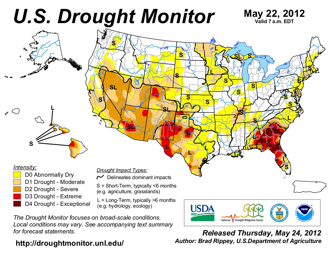
Here’s the drought update from the Colorado Water Conservation Board (Veva DeHeza):
April 2012 was the fourth warmest on record (records date back to 1895). While May has been slightly cooler, temperatures remain above average, exacerbating persistently dry conditions on the west slope and throughout the San Luis Valley. May precipitation along the Front Range corridor has improved. However, municipalities are reporting increased demand and expect to see storage levels drop if conditions persist. Evapotranspiration rates on the Eastern Plains resemble levels expected for mid-summer months. Many irrigators are using more water than normal for this time of year. All major basins have seen significant declines in snowpack. All continue to be below normal for the year. Extreme drought conditions have been introduced in the Yampa, Colorado and Gunnison River basins per the U.S. Drought Monitor. Governor Hickenlooper has expanded Drought Mitigation and Response Plan to include this region.
The last two months temperatures have been five degrees above average for most of Colorado, with some areas experiencing temperatures 6-10 degrees above normal.
The Colorado and Yampa River basins both have the lowest May 1st snowpack on record (45 year record), with 21% and 17% of average respectively. Both were also near record high this time last year.
Reservoir storage remains strong throughout most of the state, at 112% of average. The Gunnison River Bain has thehighest percent of average storage at 124%, while the Rio Grande has the lowest at 70% of average.
As of the May 22, 2012 US Drought Monitor, 96% of Colorado is experiencing some level of drought classification.D1, moderate drought, conditions remain in much of the southern Colorado, while the northern and central mountains are now classified as D2, severe, and D3 extreme drought conditions. Pockets of D2 also exist in the San Luis Valley and Crowley County.
The Surface Water Supply Index (SWSI) values range from -4 in the North Platte headwaters to -1.93 in the Big Thompson. The South Platte River Basin, which encompasses the Big Thompson sub-basin, is the only river basin that is predominantly weighted with reservoir storage this time of the year. With storage strong values appear slightly higher. All SWSI values throughout the state, utilizing the revised methodology, are negative.
Some drought indicators, in portions of the state, show conditions worse than 2002, such as the SWSI for Yampa/White and Arkansas basins, which indicates less surface water supply in 2012 than 2002.
La Niña conditions weakened to neutral. A full transition to El Niño is not expected this spring, but could occur later this summer. El Niño conditions would favor more moisture for the state.
The long term forecast for late summer (July-September) shows a tilt towards wet conditions covering most of southern Colorado, near-normal moisture over the northwestern portion of our state, and a slight tilt towards wetness in northeast Colorado.
Producers are already anticipating a low wheat harvest and rangeland conditions are poor. Dry land farmers are the most impacted at this time, although irrigators are reporting needing more water than normal for this time of year.
Fire danger remains above normal for the western portion of the state.
From the Summit County Citizens Voice (Bob Berwyn):
In response to conditions, Gov, John Hickenlooper has ordered expanded activation of the statewide drought mitigation and response plan. Counties in the Yampa, White, Colorado and Gunnison basins could see severe drought-related economic impacts, and other sectors of the state’s economy may also be affected if current weather trends continue, Hickenlooper wrote in a May 21 memo the heads all state government agencies.
Based on Hickenlooper’s order, a drought task force will start to meet regularly and state departments will assign senior-level managers to coordinate the drought response. More information on Colorado’s drought plans are online at the Colorado Water Conservation Board website.
A May 21 update from the Colorado Water Availability Task Force outlines other effects of the warm, dry spring, including evapotranspiration rates on the eastern plains that are normally seen in mid-summer. That means the soil is losing moisture fast, upping demand from irrigators. Some drought indicators, including water supply and runoff forecasts, are worse than in 2002, the last significant drought in the state. Producers in the agricultural sector are already anticipating a low wheat harvest and rangeland conditions are poor. Dry land farmers are the most impacted at this time, although irrigators are reporting needing more water than normal for this time of year.
Here’s a release from the Eagle River Water and Sanitation District (Diane Johnson):
Eagle River Water and Sanitation District customers are reminded that the normal Water Use Regulations apply year-round. The regulations govern how water is used, particularly outdoors, within Eagle River Water & Sanitation District’s service area.
“The district is responsible for protecting an adequate supply of water to its customers,” said General Manager Linn Brooks. “We promote efficient use of water at all times, but given this year’s potential water supply challenges, every customer can lessen the impact of the drought to our community by carefully considering their outdoor water needs.”
As part of the district’s general rules and regulations, the Water Use Regulations are rooted in Colorado water law and state that “water shall be used for beneficial purposes only and shall not be wasted.” This is primarily achieved by watering no more than three days per week and avoiding outdoor water use during hot and windy times of day, when water is lost to evaporation.
The complete Water Use Regulations are available at www.erwsd.org…
The district encourages customers to have their irrigation systems properly maintained because water is wasted if sprinkler heads or lines are broken or are spraying onto driveways or roads.
From The Norwood Post (Ellen Metrick):
“We’re getting customers ready for whatever’s coming down the pike,” said Town of Norwood Administrator Patti Grafmyer. The water situation this year isn’t much different from 2002, the year of the Burn Canyon Fire and town water restrictions that eventually allowed only indoor water use. That summer, the town pulled water from the San Miguel River under its conditional water right, and trucked it up to the mesa, where customers could fill tanks to water trees and shrubs.
As for gardeners in this dry year, Grafmyer said, “Hopefully they will think about how and what they plant.”
From the Snowmass Sun (Jill Beathard):
With the low amount of snow this year, it’s a bit early to run commercial rafting trips on area rivers fed by runoff. But Snowmass-based Blazing Adventures is taking trips on the Colorado River, which has the best whitewater in the state right now, according to rafting guide Ben Whitaker. “Because it’s dam-controlled they can release the water,” Whitaker said. “They get it to a decent flow, and they can maintain that flow.”
From the Associated Press via Steamboat Today:
Matthew Aleksa, a meteorologist with the National Weather Service’s Grand Junction forecast office, said a strong low-pressure system that moved through Nevada and into northern Utah before pushing its way toward Idaho overnight Saturday brought the strong and sustained winds that plagued much of Colorado, including Routt County, on Saturday. Those winds also blew dust into the sky, significantly reducing visibility in cities like Steamboat Springs. Aleksa said smoke from wildfires in neighboring states could have contributed to the haze but that the primary cause is airborne dust.
From the Glenwood Springs Post Independent (Scott N. Miller):
Diane Johnson, communications manager for the Eagle River Water and Sanitation District, said people in her office have said Gore Creek through Vail seems to have peaked for the season. The same is true farther down the Colorado River system. Eagle County Public Works Director Tom Johnson has been told the Colorado River near Glenwood Springs peaked earlier in May. Rivers are running at a relative trickle for this time of year across Western Colorado. In fact, the U.S. Geological Survey’s streamflow map showed just one local stream — Homestake Creek — running above its normal flow for May 25.
Streamflow is important for Eagle County, since there are only a few high-elevation reservoirs for use later in the season. That’s why water managers are keeping a close eye on streamflows.
From Steamboat Today (Tom Ross):
Steamboat weather observer Art Judson said Thursday that he has recorded 0.62 inches of precipitation in May at his weather station between downtown and the ski area. That leaves a little less than a week to catch up to the average May precipitation of 2.08 inches. In a typical month of May, a little snow on Mount Werner translates into cold rain at lower elevations and hits the sweet spot for the grass hay that dominates the meadows of the Yampa Valley. This year is a little different.
“The soil temperatures have climbed to the point that the growth pattern is different this year,” Hagenbuch said. The hay is further along in its growth cycle than normal, and farmers and ranchers are scrambling to irrigate earlier than they typically would. Water is in the creeks and rivers now, but it won’t be for much longer.
If there’s a silver lining, Hagenbuch said, it’s that calving season was easy this spring and the fences didn’t need mending because of the scarcity of the snowpack. That gives hay growers more time to monitor their irrigation ditches…
He is wary that a little later in the summer, the return flows from hay fields that replenish the river in most seasons won’t restore enough water to the stream for each successive hay grower down the chain to get the water their fields need.

Remember to thank a veteran for their service today. My family includes Navy, Army and Air Force men who served in World War II, Korea, Vietnam and Iraq.
From the North Platte Bulletin:
Temperatures have been as much as 6-10 degrees hotter than normal fom more than a month in many places, particularly eastern Colorado, the manager of the Colorado Water Conservation Board Office of Water Conservation and Drought Planning said May 17. Snowpack is 7 percent of normal, which means low stream-flows. More than half the state has officially been proclaimed in drought, said a Denver CBS television station.
An estimated 4 million acres of trees have been killed by beetles, which many view as a natural cycle, but the deadwood creates highly flammable fuel for wildfires.
Click here to go to the Colorado Water Conservation Board website for the presentations from the May 22 Water Availability Task Force Meeting.
I live-tweeted the meeting using hash code #cwcbwatf.
From the Arvada Press (Sara Van Cleve):
The City of Arvada has enacted voluntary water restrictions this summer to help conserve the city’s supply. Jim Sullivan, director of utilities, said the city’s water supplies are in good condition, but residents should still conserve for future dry spells. “We’re in a dry period, but we planned for this kind of dry period,” Sullivan said. “The issue would be if it continues into future years.”[…]
The most effective way to save water is to reduce sprinkler use by following the city’s watering schedule and guidelines found at www.arvada.org/about-arvada/voluntary-summer-lawn-watering-guidelines.

From The Pueblo Chieftain (Matt Hildner):
…opponents have said the plan fails to show the work leading to its conclusions.
The filings argue that it lacks data and used a faulty methodology in producing a groundwater pumping estimate of 308,000 acrefeet for the upcoming season. Nor does the plan detail recent adjustments to a state computer model designed to project groundwater use and depletions to surface water. Moreover, the objectors request an explanation of how the projected injury to surface water users was reduced from 5,016 acre-feet in a draft of the plan to 4,706 acre-feet in the final version.
Opponents of the subdistrict also argued in a Friday filing that the standard of review adopted by the court requires the implementation of the subdistrict’s plan be delayed until objections are resolved.
Also, without a plan in operation, the objectors argue that groundwater wells that injure the rights of senior surface users must be curtailed, a move that would break with nearly a century of unregulated groundwater use in the valley.
A status conference in the case has been set for Tuesday at 9:30 a.m.

From the Summit County Citizens Voice (Bob Berwyn):
One part of the planned work involves moving some of the waste rock from the mine away from running water, a technique that has proven successful in other remediation projects. A collaborative task force including local, state and federal stakeholders have been grappling with the pollution for years, as cost estimates for a cleanup have soared.
This summer, the various parties collaborating on the cleanup will also try to enter the old mine itself to try and figure how water moves through the shafts and tunnels. That may help the experts figure out if they can permanently block the water coming out of the mine with a bulkhead, according to Lane Wyatt, a water expert with the Northwest Colorado Council of Governments. “That’s the big thing, is opening up the Penn Mine … that’s kind of exciting, going in see what’s going on in there. That might help us develop some remedial options based on more than just guessing,” Wyatt said.
Other potential remediation options include a water treatment facility, or perhaps even trying to block or divert water before it gets into the mine.“The Forest Service has been involved in looking for ways to clean up the Penn Mine for many years. This is a great step forward,” said acting Dillon District Ranger Peech Keller.

From The Denver Post (Karen E. Crummy):
Current data show that surface-water levels of benzene at the point where the creek meets the South Platte River are still much higher than standards for drinking water, but remain stable. And the source of the leak — a pipe within the refinery — is fixed. But one health department official says a “mass of contamination” continues to dissolve into the groundwater, and isolated pockets of pollution — much of it underground — are spread over large areas within the refinery and off-site, making it difficult to locate.
While the state health department has tapped various methods of remediation, officials say it will take another two months to determine their effectiveness. Walter Avramenko, head of the state’s Hazardous Waste Corrective Action Unit, said it took two decades to study and remedy historical contamination at the refinery, part of a 75-year-old industrial site, and come up with a long-term management plan. “It took only a short period of time to reverse all those gains, and we’re not planning to wait another 20 years to fix it. We’re pushing the refinery very hard,” Avramenko said. “This is a very difficult, complex hydrogeologic environment for which there are no easy solutions.”

From the Colorado Water Trust website:
Join us at the 4th Annual RiverBank Fundraiser for both live and silent auctions, appetizers, an open bar, good company, and the inaugural presentation of The David Getches Flowing Waters Award. Come celebrate our successes over the past year and help us raise funds for our future efforts. We hope to see you there!
More instream flow coverage here.
![]()
From email from the IBCC:
Below are the links to the meeting notice and agenda for the May 31 IBCC meeting taking place in Breckenridge and the minutes from their February 29th meeting.
Here are the meeting minutes from the last meeting of the Flaming Gorge Task Force via email from Heather Bergman. One of the topics for discussion were water rights for the pipeline.
The Committee’s next meeting is in Siverthorne on May 30.
More IBCC — basin roundtables coverage here.
From email from Reclamation/NPS:
The Bureau of Reclamation (Reclamation) and the National Park Service have announced the current schedule for drafting the Glen Canyon Dam Long Term Experimental and Management Plan Environmental Impact Statement (LTEMP EIS). This schedule is intended to help interested parties plan for key involvement periods. The letter announcing the schedule is available in PDF format at the location below.
http://ltempeis.anl.gov/documents/docs/LTEMP_Schedule_Announced_May2012.pdf
More Colorado River basin coverage here.

From the Castle Rock News-Press (Rhonda Moore):
he 481-page summary was an indication of the job at hand for councilmembers tasked with one of the town’s most important financial decisions in years. “This is the first step in the process,” Town Manager Mark Stevens said. “This will involve multiple other meetings and opportunities for public input. This is a lot of information for everybody to start wrapping their arms around.”
The information included cost projections on full-scale, scaled-back and hybrid proposals from providers Renew Strategies, Stillwater Resources, United Water and the Water Infrastructure and Supply Efficiency project. Town staff enlisted the help of a team of water attorneys and engineers to help analyze the proposals from the four providers to arrive at a comparative analysis, said Ron Redd, utilities director.
The goal to find a renewable source of water is part of the town’s effort to wean itself of its groundwater supply and become 75 percent reliant on renewable water at the town’s anticipated buildout, Redd said.
From email from United Water and Sanitation District (Robert Lembke):
Castle Rock recently released a 425-page “Legacy Water Projects” report comparing the renewable water systems of the four applicants chosen by the town to submit proposals in August 2011. The Town’s consultants identified United as the only water system that is technically and legally capable of providing the town with 6,000 acre-feet of renewable water in a manner that is economically reasonable for its residents.
The report further confirmed that, by the year 2019, the United system becomes less expensive than the South Metro/WISE/Denver/Aurora proposal. The United system remains less expensive than WISE thereafter in perpetuity.
Under the United proposal, Castle Rock will possess ownership rights to 6,000 acre-feet of renewable water and water infrastructure while the South Metro/WISE/Denver/Aurora proposal leases the town only 3500 acre-feet of renewable water and infrastructure. Castle Rock’s report highlighted that Denver and Aurora would likely maximize their water deliveries to the town in the first few years of each decade, leading to the possibility of “no deliveries for 24 consecutive months” or “no significant deliveries during 35 consecutive months.”
The consultants also concluded that Denver and Aurora’s water delivery schedule under the WISE proposal could require South Metro to obtain up to 73,000 acre feet of storage in Rueter-Hess Reservoir in order to provide reliable water supplies to its members. Although Castle Rock already owns 8,000 acre feet of storage in the reservoir, the town would need to purchase an extra 17,550 acre feet of storage to survive the Denver/Aurora non-delivery years at an estimated additional cost of $87,775,000 – $140,400,000.
Finally, Castle Rock’s water attorneys and engineering consultants expressed serious reservations about any purchase of water from either Renew Strategies, L.L.C. (Lost Creek Basin water) or Stillwater Resources, Inc. (Box Elder Basin) due to significant issues related to the long-term reliability of the systems, lack of existing infrastructure, and poor water quality.
Copies of the Town’s engineering and legal reports discussing these matters in greater detail can be found on the United website.
More South Platte River basin coverage here.
Click here to go to Westword’s terrific in-depth look at the history, present and future of the South Platte River Corridor in Denver. I ride the river between Thornton and Denver often so thank you Joe and Jeff. Here’s an excerpt from the article:
Joe Shoemaker ran for mayor in 1971, and although he didn’t win that office, he found a cause: pushing for the cleanup of the Platte. Jeff was just back from his freshman year in college in June ’74 when his father said that Mayor Bill McNichols had asked him to head an effort to restore the river and was giving the Platte River Development Committee $2 million for the cause.
“I just remember thinking my dad was fifty and that was such a cool thing…but what did it mean?” Jeff recalls.
Fifteen months later, he found out when Confluence Park opened, the first of two targeted projects; the other was Globeville Landing Park. Confluence was at the juncture of the Platte and Cherry Creek, close to the very spot where Denver had gotten its start when gold was found just upriver in 1858. And now the Platte, and the park around it, was turning into liquid gold.
By 1982, Jeff was mining that gold. He was looking for something beyond his job as a schoolteacher, and after turning his dad down three times, he finally accepted a spot as executive director of the Greenway Foundation, the nonprofit that evolved from the PRDC, on a six-month trial basis.
Thirty years later, he’s still there. So is his almost-88-year-old father, in spirit if not in day-to-day operations. “There’s a difference I want to make clear,” Jeff makes clear. “This is and this remains my job, but my father has been a volunteer from day one. He’s not only never made a nickel off this, he’s donated six-figure money to the cause. He’s had opportunity after opportunity — but he’s avoided any conflicts. It’s not that we’re purists; it’s just that we’re realists.”[…]
Just how much abuse the South Platte itself can take is an open question. North of downtown, the river winds through an increasingly grimy and aromatic wasteland. It’s a sacrifice area, the legacy of a bargain struck long ago, a place where the rudiments of nature are subjugated to the demands of industry. For the beehives of commerce along its banks, the river isn’t a resource but a long-suffering appendage — and a handy dumping ground.
Looming over this stretch of the Platte is the Cherokee coal-fired power plant. Built between 1955 and 1968, the plant burns up to 5,600 tons of coal a day, creating steam with water drawn from the Platte and a Denver Water recycling plant, and generating enough electricity to power more than half a million homes. But Cherokee is one of the more benign neighbors. According to a recent report by Environment Colorado, the South Platte is the most polluted waterway in the state, absorbing almost 250,000 pounds of toxic chemicals a year.
One longtime contributor to that devil’s brew is the Suncor Energy oil refinery, a sprawling complex of tanks and machinery and railway sidings that hems in Brighton Boulevard on both sides. Contamination of groundwater at the site, which processes 90,000 barrels of crude oil a day, dates back decades. Suncor has been involved in cleanup efforts since it purchased the operation from Conoco in 2004, but the results have been something less than spectacular…
On a quiet, cloud-covered afternoon just around supper time, Tim Baker stands on the northern shoreline of the east pond at Elaine T. Valente Open Space with a fishing pole in his hand…
It’s not hard to see why he chose this place. On a clear day the park boasts some spectacular sightlines. To the southwest, you can catch the outline of the Denver skyline traced ever so faintly against a sprawling mountain-vista backdrop. Nestled on a stretch of road on East 104th Avenue between McKay and Brighton Roads, Elaine T. Valente Open Space comprises three fishable ponds that are linked together by an assortment of arterial bike and hiking trails that wind around the park and snake their way along the South Platte River. Motorists making their way down East 104th are most likely unaware of the wildlife and recreational activity taking place here. From the road, it looks like nothing more than a quaint roadside lake with a picnic shelter. Last Friday, a host of local politicians, led by Secretary of the Interior Ken Salazar and Governor Hickenlooper, announced that they had formed a partnership that will create uninterrupted trails and links that will connect Rocky Mountain National Park, Rocky Mountain Arsenal National Wildlife Refuge, Rocky Flats National Wildlife Refuge and the numerous trail systems in between; Baker’s fishing hole will be part of that plan.
Click here to take a video bicycle ride down the South Platte River Trail.
More South Platte River basin coverage here.

From the Cañon City Daily Record (Rachel Alexander):
Voters in Penrose were filling two seats on the Penrose Water District Board. They selected Charlotte Norman, with 218 votes, and Richard Hilderbrand, with 196 votes, to fill the positions. Paul Maye also ran for the seat.

From the Wet Mountain Tribune (Nora Drenner):
Elected to the RMW board were current board members Charles Bogle with 147 votes and Chris Haga with 99 votes, followed by newcomer Ken Felty with 130 votes. Also running for a seat on the board was Dana Wyrick who received 78 votes. There were 760 eligible voters in the RMW election with 170 voters casting a vote, a 22 percent voter turnout.
The three will take office on June 7.
Rounding out the RMW board are Peggy Dunlap and Dee Hoag who were not up for re-election.
More Custer County coverage here.
![]()
From the Valley Courier (Ruth Heide):
After an alternative proposal by roundtable member Charlie Spielman was defeated with only two votes supporting it, the roundtable voted to fund the study for $99,564 out of its basin account, with Spielman casting the only dissenting vote.
Rio Grande Roundtable Chairman Mike Gibson said the basin account had $263,000 in it as of April 12 and would probably be receiving more money when the state begins its new fiscal year this summer.
Rio Grande County Commissioner and roundtable member Karla Shriver, who represented the applicants on Tuesday, abstained from voting. She told the basin-wide water group the county wants to rely on scientific data to make informed decisions. While welcoming economic development, the commissioners want to ensure water quality, public safety and the agricultural economy that is the foundation of Rio Grande County, she explained. “We need economic development, but we need to do it in a prudent manner. That’s why we need information.”
She said the county is working closely with the Colorado Oil and Gas Conservation Commission (COGCC.) For example, the county leaders contacted the COGCC with concerns about leakage at the old Jynnifer well up Old Woman’s Creek. The site has been abandoned since 1987 but still has the well head and storage tanks there, where a leak has developed.
More IBCC — basin roundtables coverage here.

From the Arvada Press (Darin Moriki):
The Denver Metropolitan Wastewater Reclamation District, which serves all but three cities in Jefferson County, is carrying out a $1.2 billion construction project to upgrade its treatment facilities to comply with discharge permit requirements. Steve Frank, the Denver Metropolitan Wastewater Reclamation District’s public information officer, said $211 million of that amount is being spent to construct a secondary treatment area to filter out additional ammonia and nitrates from treated waters. He said the project is scheduled for completion by Jan. 1, 2015.
State water-quality officials are considering more changes to discharge regulations…
Like many of the other 59 local governments served by the treatment plant, the city of Arvada passes wastewater treatment costs to homeowners and charges an additional fee to maintain the city’s 408-mile sewer system. Steve Wyant, Arvada’s wastewater superintendent, said the city is already addressing needs to replace miles of aging sewer infrastructure and expanding it to accommodate growth in the city’s northwest corner, including Candelas. He said the project cost is already estimated at almost $12 million.
More wastewater coverage here.

From email from Reclamation (Kara Lamb):
As everyone has likely heard by now, we did haven’t much snow pack this year. As a result, I haven’t had much run-off information to share over the last several weeks. But, now that we are on the brink of summer, I thought a Memorial Weekend update on Fryingpan-Arkansas Project reservoirs and operations might be helpful.
We project that we will be importing below our average amount of water on the Fry-Ark. Typically, the project imports around 54,000 acre-feet of water a year from the upper reaches of the Fryingpan River basin. This year, we project we’ll only divert about 12,400 acre-feet of water.
That said, the Voluntary Flow Program for the Arkansas River is ON.
Today, Twin Lakes is releasing about 30 cfs. to Lake Creek. It has a water level elevation of about 9185 feet–that’s about 75% full. 75% full is actually close to average for this time of year.
Turquoise Reservoir is sitting at a water level elevation of about 9840 feet. That’s roughly 62% full, but Turquoise is usually filling this time of year with west-to-east slope water imports from several different projects. So, this water elevation is about average for May.
Pueblo Reservoir is at a water elevation of 4871 feet. That is roughly 70% full. But, 70% full is a little higher than we would see the reservoir this early in the season. This is because what run-off we did have peaked earlier than it would in a more average snow pack year.
Over on the west side of the Continental Divide, Ruedi Reservoir is slowly filling. Currently, it is at a water level elevation of 7745 feet. That’s roughly 81% full and slightly above average for this time of year. Like the East Slope, the West Slope also saw run-off flows come early this spring. We have maintained a release of 110 cfs from Ruedi to the Fryingpan River and that does not look likely to change for a while.
If you plan to visit one of our reservoirs over the holiday weekend, check out its current operations via our Colorado Lakes and Reservoir website. We have up-to-date information posted there.
From The Pueblo Chieftain (Chris Woodka):
The voluntary flow program initiated on the Upper Arkansas River in 1990 seeks to maintain water levels for rafting and fishing interests. One of the chief sources of water is the Fryingpan-Arkansas Project, which imports water from the Colorado River basin. “Water groups are coming together to make this season work,” said Rob White, Park Manager at the Arkansas Headwaters Recreation Area. The problem is that the dwindling snowpack on the Western Slope is expected to provide little additional water this year.
“If the Bureau of Reclamation doesn’t have the water, it can’t provide it,” said Bob Hamilton, engineering supervisor for the Southeastern Colorado Water Conservancy District.
Participants in the agreement are Colorado Parks and Wildlife, Colorado Trout Unlimited, the Southeastern district, the Colorado Department of Natural Resources and the Arkansas River Outfitters Association. Reclamation did not sign the agreement, but seeks to time releases from Turquoise and Twin Lakes to meet target levels for the Arkansas River. Those releases also can be determined by large municipal operators — Colorado Springs, Pueblo and Aurora.
More Fryingpan-Arkansas Project coverage here.

From email from Reclamation (Kara Lamb):
As everyone has likely heard by now, we didn’t have much snow pack this year. As a result, I haven’t had much run-off information to share over the last several weeks. But, now that we are on the brink of summer, I thought a Memorial Weekend update on Colorado-Big Thompson Project reservoirs and operations might be helpful.
Over on the west side of the Continental Divide, we’ve seen a steady release from Green Mountain Reservoir to the Lower Blue River of about 75 cfs. That does not appear likely to change in the near future. The reservoir is currently at a water level elevation of about 7920 feet, that’s about 64% full. That is actually slightly above what we might normally see in late May. This is because run-off in the Blue River Basin started early this year and we began filling at Green Mountain on April 1.
Similarly, storage levels at Granby, Willow Creek and Shadow Mountain reservoirs–where we collect the water that will be diverted to the East Slope–are also slightly higher than is typical for this time of year. Like Green Mountain, that is because we saw run-off start and peak early on the upper reaches of the Colorado River. Currently, Granby has a water level elevation of about 8263 feet, around 79% full, and is releasing about 53 cfs to the Colorado River at the Y gage. In a more normal snow pack year, we’d be releasing 75 cfs at the Y gage.
Willow Creek Reservoir, whose water is pumped up to Granby is about 82% full and Shadow Mountain Reservoir is around 96% full–it usually is.
Following the project over to the East Slope, we have seen fairly typical water elevations in Lake Estes for most of the spring. Releases from the reservoir through Olympus Dam to the Big Thompson River have not fluctuated much, averaging around 120 cfs for the past several weeks. Currently, releases to the Big T are closer to 125 cfs.
Pinewood and Flatiron water levels fluctuate fairly often. Water elevations rise and fall daily, depending on power generation at the Flatiron Power Plant. Over the last couple of weeks, Pinewood’s elevation declined, but we are steadily bringing it back up again. Next week, visitors to both reservoirs might notice some surveying going on. Reclamation employees will be out at the reservoirs looking at sediment.
The pump is on to Carter Lake and its water level elevation continues to rise. It’s currently at an elevation of 5735 feet, about 77% full. While it will go up in elevation a little more, how high it gets now depends on downstream demands. Demands will come up with hot and dry weather.
Horsetooth is in a similar situation. The reservoir saw its highest water level elevation (about 5424) for the summer season at the end of April/early May. It has been slowly dropping this month and is currently around 5419 feet–that’s roughly 87% full. Like Carter, summer water levels at Horsetooth depend largely on downstream demands, which depend largely on weather. We’ll see how hot and dry it gets.
If you plan to visit one of our reservoirs over the holiday weekend, check out its current operations via our Colorado Lakes and Reservoir website. We have up-to-date information posted there.
More Colorado-Big Thompson Project coverage here.

From the Boulder Daily Camera (Bob Juhl/Joseph A. Wilson/Carolyn Cutler):
Erie and Lafayette and the Left Hand Water District, which serves Eastern Boulder County, have spent the past decade studying the best methods to ensure our ability to access enough water to meet our future dry year needs. Together with 12 regional water providers, we determined that NISP is our best option from more than 200 options studied. NISP is not only the most environmentally sensitive project, but also the best solution from an economic standpoint.
Some believe the region will be fine without NISP. We wholeheartedly disagree. In fact, the Draft Environmental Impact Statement states clearly that if NISP is not built, one of the consequences will be the elimination of 100 square miles of irrigated farmland in Northern Colorado because communities will have to purchase necessary water supplies from farmers. One of NISP’s goals is to keep water on farms to ensure their continued operation.
Northern Colorado will continue to grow regardless of whether NISP is built or not. Colorado needs to keep available water supplies in the state for its citizens. From 2009 to 2011 Colorado saw more than 1.4 million acre feet of water leave the state to Nebraska over and above what is required. That’s enough water to supply the entire Front Range of Colorado with water for a year…
Please go to gladereservoir.org for more information about NISP and an upcoming support rally scheduled for July 24.
More Northern Integrated Supply Project coverage here and here.

From The Pueblo Chieftain (Jim Valliant):
When the early agricultural producers developed the Arkansas River for irrigation, they began to battle the salt problems in the basin by digging miles of drainage ditches and also installing miles of sub-surface tile drainage systems. This battle continues today.
Salts and waterlogging, due to high water tables, are causing crop yield losses of 10 to 90 percent on irrigated farmland throughout the Arkansas River basin according to studies by Tim Gates and Luis Garcia, Colorado State University civil engineers.
Farmers have to use every source of skills that they have to battle this intruder.
So farmers have to be amateur agronomists, chemists, engineers, entomologists, financial planners, marketers and soil scientists.
The good news is that farmers are winning this battle through improved technology. New seed development, improved cultural methods and irrigation technology are leading the attack on this age-old enemy. Alfalfa is averaging around 5 tons per acre with many fields exceeding that yield. Corn yields have broken the 200 bushel per acre barrier. Wheat yields are in the 100 bushel per acre range and many vegetable yields have doubled because of new technology such as sub-surface drip irrigation, plastic mulch and new varieties.
More Arkansas River basin coverage here.
From KRDO.com (Rana Novini):
Colorado Springs Utilities says the April ruling is unfortunate and they have always met water quality standards. They joined the City of Colorado Springs, and the State of Colorado in filing an appeal against that ruling.
On Friday, Pueblo County District Attorney Bill Thiebaut stood near the Fountain Creek Flood Control marker in Pueblo and vowed he would not stop fighting against SDS. He held up two jars of water: one he said was from Lake Pueblo, the other from Fountain Creek. “You can see (the latter jar) is rather muddy and contaminated as compared to the Lake Pueblo water,” Thiebaut said. He attributes the pollution to Colorado Springs’ development projects, saying the runoff ends up in Fountain Creek. He says that Colorado Springs takes the clean water in Pueblo Reservoir and returns used, dirty water to Fountain Creek.
Mark Pifher of Colorado Springs Utilities works directly with water quality regarding SDS. He tells KRDO NewsChannel 13 that the pollution in Fountain Creek has nothing to do with SDS. “At this point in time, Southern Delivery is not yet operational. So that’s the ambient condition, if you will, of Fountain Creek,” Pifher said.
In a written statement from the Tenth Judicial District, Thiebaut claims the pollution in Fountain Creek has caused illness to Pueblo County residents. But Pifher says Utilities has never been made aware of any illnesses.
From The Pueblo Chieftain (John Norton):
In April, District Judge Victor Reyes ruled on a suit filed by Thiebaut and threw out a state water quality permit the Colorado Water Quality Control Commission gave the project.
Reyes ruled that the commission ignored potential impacts of growth on Fountain Creek water quality and failed to follow its own procedures in upholding a 2010 permit under section 401 of the Clean Water Act.
Friday afternoon, Thiebaut called on the state and Colorado Springs to give up the appeal. He held up jars of clear Pueblo Reservoir water and cloudy water from Fountain Creek.
Standing near the flood control marker across from the El Centro del Quinto Sol community center, he said, “Now, Colorado Springs wants to take this pristine (lake) water, use it in Colorado Springs and then discharge more of its used wastewater and stormwater into Fountain Creek.
From the Colorado Springs Independent:
…a new study from Summit Economics LLC says Colorado Springs residents pay less ($4.63 per capita annually) than those of every other Front Range city. The average is $52.11. To reach that average, El Paso County would have to impose a half-percent sales tax (50 cents on a $100 purchase), a property tax of 5.8 mills ($93 on the tax bill of a $200,000 house) or a $5.35 per month fee per home. Any of those taxing methods would yield the roughly $36 million a year needed to tackle a $600 million backlog for the county, Colorado Springs, Manitou Springs, Fountain and Monument, the study says.
And the issue lies here, not downstream in Pueblo County, which accounts for only 1 percent of the region’s stormwater infrastructure needs, the study found.
The Fountain Creek Watershed Flood Control and Greenway District, which covers portions of Pueblo and El Paso Counties, funded the study, and its manager Larry Small says the board is eying a November 2013 election if a tax increase is sought.
From the Colorado Springs Gazette (Daniel Chaćon):
Bach said his administration inherited “upwards of a billion” dollars in unfunded capital needs, including stormwater, and that the city needed to “come to grips” with the problem. “The day of reckoning is in front of us,” Bach said.
The lack of stormwater funding has other consequences that City Attorney Chris Melcher has said obligates Utilities, a billion-dollar-plus enterprise of the city. Stormwater is a crucial element of the 62-mile Southern Delivery System water pipeline that Utilities is building between Colorado Springs and Pueblo…
The Board of Pueblo County Commissioners, which issued the so-called 1041 permit for SDS, is now applying pressure on the city, too. The board sent Bach and the council a letter May 3, saying it was “encouraged” by reports that the city was exploring ways to fund stormwater but that it needed to act fast…
“A key component was the Stormwater Enterprise,” they wrote. “Unfortunately, in December 2009, only a few months after it obtained its SDS permits, Colorado Springs Council voted to abolish its Stormwater Enterprise fees.”
SDS spokeswoman Janet Rummel said the city’s stormwater issue is much broader than SDS. “Not only is utilities infrastructure impacted by stormwater run-off, but City and County roads and bridges are also affected for example,” she said in an email.
More coverage from the Colorado Springs Independent (Pam Zubeck):
After the enterprise was dismantled in 2009, the Springs City Council assured Pueblo County that a replacement funding source would be developed, Pueblo County commissioners note, but more than 2.5 years later, no such funding has been secured.
Pueblo County issued a construction permit for SDS, and that permit could be rescinded if Colorado Springs doesn’t live up to its promises.
County President Pro Tem Jan Martin wrote a letter to Pueblo County dated May 10, two days after Bach talked of a stormwater-related “day of reckoning” awaiting the Springs. In it, Martin says, “Protecting our watershed is a high priority for City Council …”
Really? Where’s the evidence? Rather, the Council is busy getting its package of road projects together to be included in an extension of a sales tax for the Pikes Peak Rural Transportation Authority. The tax doesn’t sunset until the end of 2014, but Councilors and others are rabid to get it renewed and want it on this November’s ballot.

It’s been a while since I’ve published one of Justice Hobbs’ poems. Here’s his poem, Organic Garlic Offering, from the current Colorado Water 2012 Book Club selection, Living the Four Corners: Colorado Centennial State at the Headwaters. Hobbs is inspired by his son Dan who farms organic garlic below a ditch in the Arkansas Valley.
Organic Garlic Offering
Pick a spot of Colorado
sun below the ditchOctober morning
plant them firm,To root your hopes
set them looseBut turn
some water inJuly’s the harvesting,
Purple Glazer, Silver WhiteMusic Pink, Romanian Red,
Chesnok Inchelium, California Early,Heirloom pungent, easy peel
good for salsa, pestosEating fresh and clean
saving this good farmland
Reprinted, with permission, from Living the Four Corners: Colorado Centennial State at the Headwaters by Justice Greg Hobbs. Click here to order the book from Continuing Legal Education Inc.
Here’s the link to Tom Romero’s review of the book. From the review:
The four great rivers of the American West (the Colorado, the Platte, the Arkansas, and the Rio Grande)—whose headwaters sit high in the peaks of Colorado’s Rocky Mountains—are threatened with silence. Because of industrial mining and large-scale irrigation, energy development, rapid large-scale urban growth, and climate change, these venerable rivers seemingly are taxed beyond their sustainable limits. Their vulnerability threatens the livelihoods of millions of people who have long relied on these rivers. Once majestic and unpredictable bodies of water, the headwaters of the Centennial State have become tightly controlled, over-managed cisterns on which every single drop is drained.
Nevertheless, as Justice Greg Hobbs reminds us in Living the Four Corners, these rivers continue to inspire awe and wonder, perhaps because of our deep-rooted reliance on the river systems for our economy, politics, and culture—or perhaps because we simultaneously recognize and take for granted each river’s persistence and durability.

Justice Hobbs has a new book just out, Into the Grand. Click here to order a copy. From Hobbs’ authors note:
I am led southwesterly by the best of guides. They include Kristin Kuckelman of Crow Canyon Archaeological Center, Rickey Hayes of the Ute Mountain Tribe, Michael Welsh of the University of Northern Colorado, Ken and Ruth Wright of the Wright Paleohydrological Institute, and Kate Thompson, who I met on the river when I was fishing with brother Will. Kate’s stunning cover photograph of lower Glen Canyon bending to Marble Canyon calls on all that’s Grand. To our journeying grandchildren, Joni, K.J., Shannon, Ella, Quinn and Grace, may you enjoy the glow of your very many glimmerings.
More Colorado Water 2012 coverage here.

From Steamboat Today:
Routt County Planning Director Chad Phillips confirmed Wednesday that the Board of Commissioners approved plans to retain groundwater quality consultant Tom Myers, of Reno, Nev. Myers’ role will be to advise the county on requirements that will be used in the future to guide when and how energy companies drilling oil and gas wells here will be made to install test wells to detect any pollution of aquifers resulting from their activities.

From email from Jan Cederberg: “I thought I would let you know we won the recall!”
From The Colorado Springs Gazette (Bob Stepens):
Nothing changed in the Cherokee Metropolitan District as Tuesday’s attempt to recall three board members was unsuccessful. Jan Cederberg, Dave Hammers and Bill Beahan all survived the recall effort.
“I was worried,” Cederberg said. “I’m just so happy that people listened to what we were telling them and that we are going to finish our time on the board and do our job.”
Here’s the link to the Colorado Watershed Assembly’s conferences webpage for all the skinny on the conference. Be there or be square.
More instream flow coverage here.
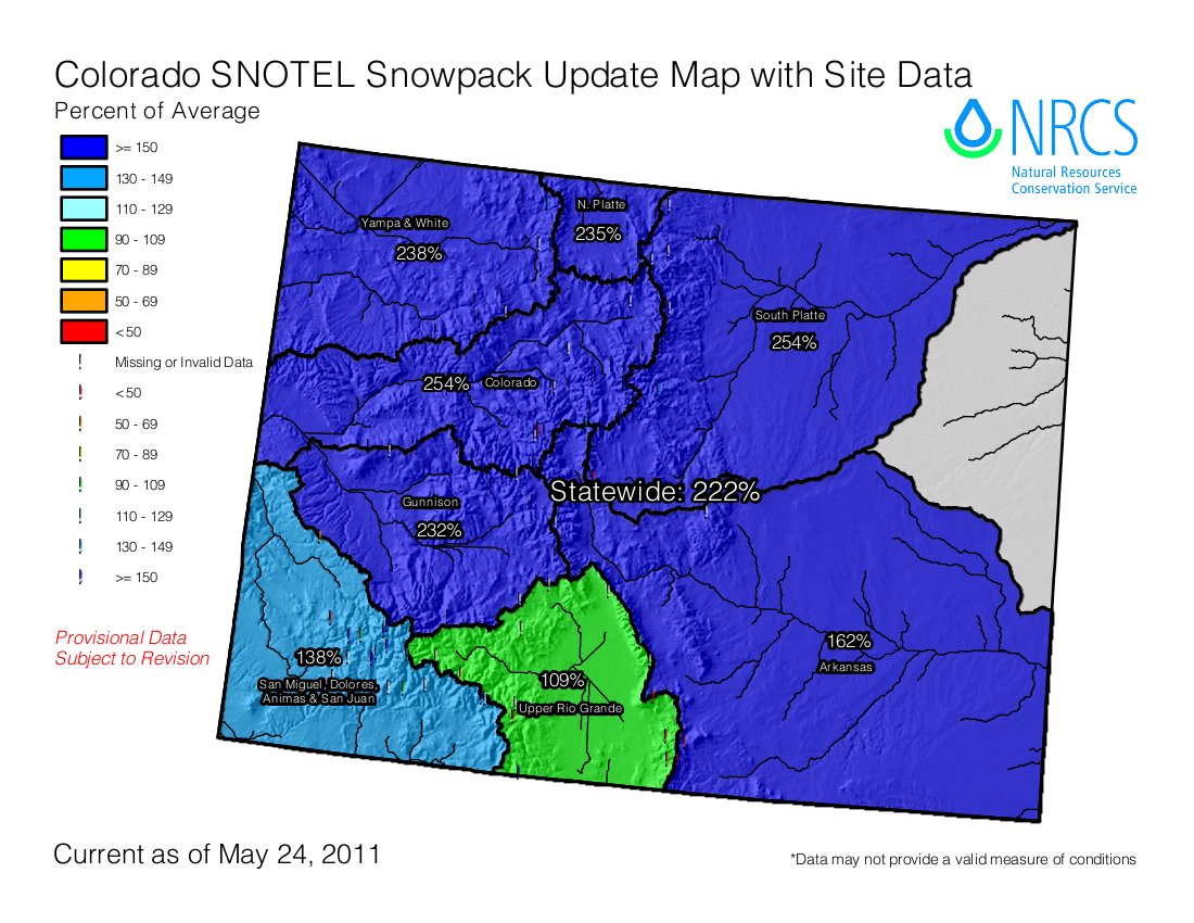
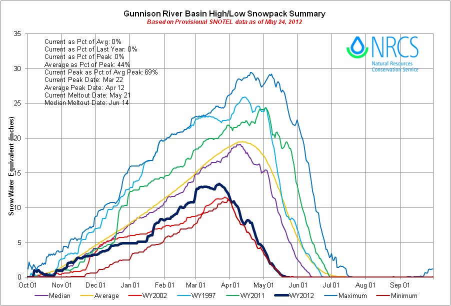
Click on the thumbnail graphics for the Basin High/Low graph for the Gunnison River basin, the statewide snowpack map, and for those of you that remember the good old days of 2011, the May 24, 2011 Colorado snowpack map.
From the Drovers Cattle Network (Rich Keller):
Snowpack is 7 percent of normal, which means low stream flows are in place, and temperatures are averaging about 10 degrees warmer than normal. More than half the state has been proclaimed as officially in drought, explained the Denver CBS television station.
“It’s dry and it’s not going to easily catch up,” state climatologist Nolan Doesken told the station reporter. “When you look back to 2002, we only got about one quarter of the average runoff in our major rivers and streams, and that’s the same sort of magnitude we’re looking at, and that’s down there at the level of worst of record.” Doesken said…
In January, the governor proclaimed 2012 “Year of Water.” The governor’s resolution identifies a clean and sustainable water supply as an essential element to the health and economy of Colorado and its neighboring states. U.S. Sens. Mark Udall and Michael Bennet recently sponsored a federal resolution honoring the governor for addressing the water issue head on. But it is obvious that resolutions and proclamations won’t do much to help get through this current problem.
How much agricultural production will be limited by the water shortage, especially since much of the state’s agricultural production is irrigated, has not been addressed in recent news accounts.
Here’s a guest column written by Colorado River Basin Roundtable member, Greg Trainor, running in the Grand Junction Free Press that looks at the question. From the article:
In Northwest Colorado, where energy development is a major industry and we hear a constant buzz about oil shale (will it or won’t it take off?), the Yampa-White and Colorado Basin Roundtables determined that water demands from the energy industry must be estimated and a plan developed for where this water might come from. The roundtables commissioned an extensive study to find the answers.
The study showed that water use for oil shale has the potential to dwarf all other energy sector demands for water — but that these needs can probably be met with water from the White River Basin through existing and new reservoir projects.
The technology of a future oil shale industry is uncertain, so future water demands are also uncertain. Past industry efforts and current experimental development employ an array of above-ground and in situ (in place) technologies to extract oil from rock, and projected water use varies among these technologies. The study developed high, medium and low oil production and water use scenarios to develop a range of plausible water use estimates.
The study’s high water use estimate uses data from Dutch Shell’s in situ conversion process, which requires electrical heating and cooling. Water needs include water related to supplying electricity as well as directly in the extraction process. At a high production scenario of 1.5 million barrels/day of oil production, this scenario yields an overall estimate of 110,000 acre-feet of water use per year.
This final “high” estimate is significantly lower than the one generated in the first phase of the study. The earlier estimates assumed all energy needs for extracting oil from shale would be met by coal-fired power plants, while Phase II more realistically assumed that the industry would use gas-powered plants, which use much less water.
The study identified three water supply projects in the White River Basin that could potentially meet an annual demand of 110,000 acre feet/year. These three projects are not the only water supply option available, but do demonstrate that the water needs can be supplied from the White River, via development of junior decrees, with reasonable development costs.

Here’s the link to the Protect Colorado Water website. They are in the process of gathering signatures to get the initiatives on the fall ballot. Here’s the link to their news page.
From the website:
On April 16th, the Colorado Supreme Court approved the text of two state-wide ballot initiatives – 3 and 45 – that create “an obligation to protect the public’s interests in water” and prevent any use that would cause “irreparable harm” to water. The two initiatives, drafted by Richard Hamilton and Phil Doe, were released to the public for collecting signatures.
Meanwhile, here’s an update from one of the opposition organizations, the Colorado Water Congress (Doug Kemper):
…the Colorado Secretary of State’s website posted that the final form for the petitions to collect signatures for Public Trust Initatives #3 and #45 have been approved. Also stated is that ballot proponents have until August 6 to collect signatures. This is a full month longer than we had originally believed. Regardless, the signature collection process may now begin…The Water Congress Board has taken a position to oppose the Public Trust Initiatives.
More 2012 Colorado November election coverage here.
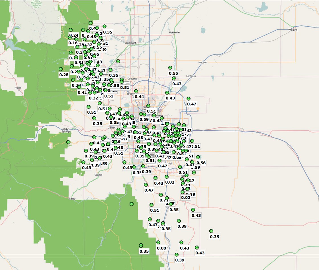
What a nice rain event yesterday here in Denver. Click on the thumbnail graphic for the 24 hour precipitation map from the Urban Drainage and Flood Control District. The station nearest Gulch Manor is reporting .57 inches.
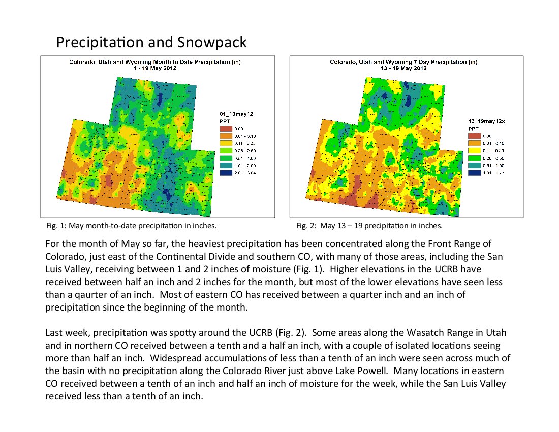
One change made during this week’s webinar was the recommendation to classify Larimer County and points east of there in D2 drought. Here’s the link to this week’s webinar summaries from the Colorado Climate Center. Click on the thumbnail graphic for the precipitation summary.
A new drought map is due out today from the U.S. Drought Monitor.

Here’s the link to the Department of Interior’s America’s Great Outdoors Highlighted River Projects webpage. Here’s the link to the Dolores River release. Here’s an excerpt:
The Dolores River Partnership was formed in 2008 and is a two state, citizen driven partnership with the goal of restoring approximately 200 miles of the Dolores River from McPhee Reservoir to its confluence with the Colorado River in Utah. Project goals include improving public safety, the removal of tamarisk and other noxious weeds, improving fish habitat, the development of education and stewardship opportunities, and expanding opportunities for youth employment.
This citizen driven project is focused on restoring riparian vegetation through the removal of tamarisk and other invasive species along the Dolores River and the planting of native cottonwoods and willows. Youth groups will assist with invasive species control and native species planting. Tamarisk removal and native vegetation plantings will reduce the risk of wildfire, increase in-stream water flows, and improve stream bank stability thus improving habitat conditions for native fish species.
Thanks to KUNC (Emily Boyer) for the heads up.