
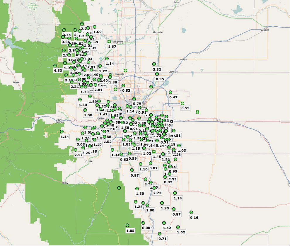
Click on the thumbnail graphic for the seven-day precipitation map for the Metro Denver Area from the Urban Drainage and Flood Control District.
From The Denver Post (Nancy Lofholm):
This year’s dearth of water is creating headaches across Colorado from farm fields to home faucets as water managers and users try to stretch low to no water levels. The state’s drought can be pictured in vivid colors on Colorado Climate Center charts and maps where red splotches across northwestern Colorado and in part of the Eastern Plains indicate extreme drought. The orange and tan that cover everything else west of the Continental Divide signal severe to moderate drought.
Precipitation charts for much of the state look like the flat line on the monitor of a dying patient.
“Things are tight” is how Uncompahgre Valley Water Users Association manager Steve Fletcher sums up the situation for the water users on the 80,000 acres his association covers. “Tight” in that farming belt means users are getting only 70 percent of their normal allotment of water. For the farmers, that means working nearly around the clock to switch around irrigation water so everything gets a partial drink…
Not all the water news is bad around Colorado. John Harold, owner of the Tuxedo Corn Co. in Olathe, said he has been able to manage with 70 percent of his water — and is starting to pick sweet corn this week. The harvest is 12 days earlier than normal years because of the hot temperatures. He would have been picking corn last week except that his fields just got a soaking for several days and were too wet and muddy. “We’re doing good,” he said. “We’re going to have corn this week.”
Meanwhile, the recent hot spell broke records across Colorado. Here’s a report from Bob Berwyn writing for the Summit County Citizens Voice. From the article:
Most of the state sat under a strong ridge of high pressure most of the month, reflected by the Denver weather stats, record daily highs were recorded June 4 and June 9, 17, 18, 25 and 26. Late in the month, Denver also recorded a five-day stretch with highs climbing above 100 degrees June 22-26) for only the third time in the city’s weather history. The previous five-day streaks were Jul 4-8, 1989 and July 19-23 in 2005. The 105-degree readings on June 25 and 26 were both all-time temperature records for the month of June and tied Denver’s all-time high for any month…
In Summit County, June precipitation was also well below normal, with the Dillon site reporting only 0.38 inches of water, only about a third of the average 1.14 inches. There were only four days with measurable precipitation, as compared to 11 on average.
From the Vail Daily (Scott N. Miller):
“Everything helps, but a tenth of an inch here and a tenth of an inch there isn’t really going to do us much good,” said Diane Johnson, of the Eagle River Water & Sanitation District. In fact, showers over the past couple of days have put just small spikes in local streamflows…
Eagle County’s in a little better shape than the Front Range foothills, but fire managers there have reported that standing trees are just about firewood dry. Getting more moisture into those standing trees will require deep, soil-soaking rain and lots of it. And even that may not be sufficient to revive the finer fuels that can spread fire. “The grasses may have already cured out and may not green up again until next year,” Eagle River Fire Protection District Chief Karl Bauer said.
From Steamboat Today (Brent Boyer):
The National Weather Service confirmed Saturday that the official weather monitoring station in Steamboat recorded 1.78 inches of rain in the 24-hour period from 7:30 a.m. Friday to 7:30 a.m. Saturday. That easily bested the previous July single-day rainfall record of 1.39 inches established on July 14, 1937. Although the 1.78 inches of rain established a new record, the spotty nature of Rocky Mountain thunderstorms proved true again Friday. Other unofficial weather monitoring stations in various locations throughout the city picked up 0.69 inches, 0.72 inches and 1.45 inches of rain, according to National Weather Service meteorologist Travis Booth. Regardless, the 1.78 inches will be the total that is referenced by history. Buoyed by that rainfall, Steamboat had received just short of 2 inches of rain through the first six days of the month. That already surpasses the average July total of 1.51 inches…
The recent rain, combined with additional water releases from Stagecoach Reservoir, continue to prop up flows in the Yampa River through Steamboat. The river was flowing at 126 cubic feet per second under the Fifth Street Bridge early Saturday evening. That flow remains above the 85 cfs threshold required for recreational activities like tubing. However, Colorado Division of Parks and Wildlife has not lifted the voluntary ban on fishing the town stretch of the Yampa River.
From The Greeley Tribune (Nate A. Miller):
The storms Friday and Saturday nights marked the first significant rainfall in the county [Weld] since early June. Saturday’s storm brought the heaviest rain to the northern and southern parts of Weld, though about half an inch fell in Greeley, according to the National Weather Service. Near Dacono, where more than 1 inch of rain fell, Interstate 25 was closed Saturday night near Dacono from mile marker 232 to mile marker 235 because of flooding…
Jim Kalina, a meteorologist with the National Weather Service in Boulder, said the heaviest rain in Weld came in the northern part of the county. About 4 miles north of Purcell, about 2 inches fell, based on radar estimates. Not much rain fell east of Kersey, he said…
Outside of Greeley, much of the rest of Weld saw about half an inch of rain, though precipitation totals varied widely throughout the county, according to data compiled by the Community Collaborative Rain, Hail and Snow Network.
Doesn't matter how dry it gets in the coming days. Weekend rains will benefit farmers for weeks to come. #drought
— Bobby Magill (@bobbymagill) July 9, 2012
Last weekend's rains pushed the Poudre River to its highest flows of 2012. Rare event to have post-runoff annual peak flows. #drought
— Bobby Magill (@bobbymagill) July 9, 2012