
From the National Weather Service Grand Junction office:
…THE NEXT WINTER STORM WILL IMPACT EASTERN UTAH AND WESTERN COLORADO FRIDAY AFTERNOON INTO SUNDAY…
ANOTHER PERIOD OF MOUNTAIN SNOWFALL IS EXPECTED TO DEVELOP LATE FRIDAY AFTERNOON AND CONTINUE INTO SUNDAY AS A STRONG PACIFIC STORM SYSTEM MOVES ACROSS THE REGION.
A STRONG LOW PRESSURE TROUGH WILL DROP SOUTHEASTWARD THROUGH CALIFORNIA FRIDAY AND TRACK THROUGH THE DESERT SOUTHWEST SATURDAY…FINALLY EXITING ONTO THE PLAINS SUNDAY. AS A RESULT…PRECIPITATION WILL BEGIN TO SPREAD INTO THE AREA BEGINNING FRIDAY AFTERNOON…INITIALLY FAVORING THE MOUNTAINS OF EASTERN UTAH AND SOUTHWEST COLORADO. SNOWFALL WILL INCREASE AND BECOME WIDESPREAD ACROSS ALL MOUNTAIN AREAS FRIDAY NIGHT AND SATURDAY AS THE UPPER LEVEL STORM SYSTEM MOVES INTO ARIZONA. THE STORM SYSTEM IS EXPECTED TO LIFT ACROSS SOUTHERN COLORADO SUNDAY WITH THE POTENTIAL FOR WRAP AROUND MOISTURE TO BRING ADDITIONAL SNOWFALL…ESPECIALLY ACROSS THE NORTH. SNOW LEVELS WILL LIKELY START OUT ABOVE 7000 FEET ON FRIDAY BUT FALL TO THE HIGHER VALLEY FLOORS BY SATURDAY MORNING AND TO LOWER VALLEY FLOORS ON SATURDAY NIGHT. IN ADDITION…GUSTY SOUTHWEST WINDS WILL PRODUCE LOCAL AREAS OF BLOWING SNOW FRIDAY AFTERNOON AND EVENING. ON SATURDAY…WINDS WILL DIMINISH SOMEWHAT…AND THEN WINDS WILL BECOME NORTHERLY ON SUNDAY AS THE SYSTEM SLOWLY EXITS THE REGION.
WHILE THERE CONTINUES TO BE SOME UNCERTAINTY IN THE TRACK AND DURATION OF THIS STORM…IT HAS THE POTENTIAL TO PRODUCE SIGNIFICANT SNOW ACCUMULATIONS ESPECIALLY FOR THE MOUNTAINS.
#ECMWF continues to dry slot most of Southern Colorado during this upcoming weekend storm. North of I-70 has best shot at moisture #cowx
— Brian Bledsoe (@BrianBledsoe) March 5, 2013
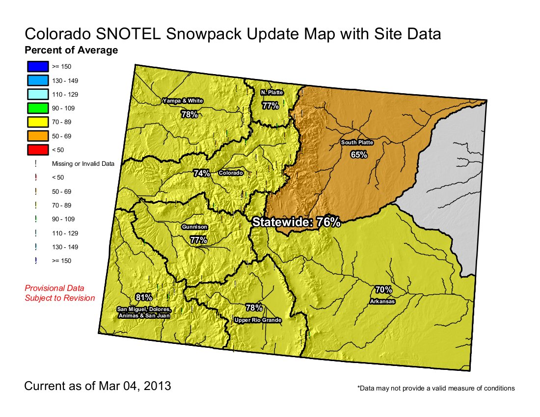
Meanwhile, snowfall in Summit County was close to normal in February. Here’s a report from Bob Berwyn writing for the Summit County Citizens Voice. Here’s an excerpt:
In Breckenridge, long-time weather observer Rick Bly said he tallied 25.4 inches of snow for the month. The long-term average is 23.5 inches. The snow-water equivalent was also slightly above average, at 1.88 inches compared to 1.71 inches. The snowfall, combined with cool temperatures, helped maintain the snowpack but didn’t make much of a dent in the seasonal deficit. For the year to-date (starting Oct. 1), snowfall is still about 30 percent below average, at 69,5 inches. The average, based on records going back to the late 1800s, is 101.5 inches. This year’s total seasonal snowfall is also lagging well behind last winter, according to Bly, who reported that, by this time last year, he had measured 95.2 inches of snow at the end of February, about 30 inches more than this winter…
In Dillon, Denver Water observers reported 15.5 inches of snow for the month, about 4 inches below the long-term average (18.6 inches). All that snow fell in 1- to 2-inch increments and delivered a snow-water equivalent of just 0.75 inches, well below the average of 1.20 inches for the site.
MORE COLORADO SNOW! @breckenridgemtn 8″ / @vailmtn 5″ / @keystonemtn 4″ / @beavercreekmtn 3″
— Snow.com (@snowdotcom) March 5, 2013