Click here to view a photo gallery from the spill site. Thanks to Aspen Journalism for the link.
From The Grand Junction Daily Sentinel (Dennis Webb):
Three monitoring wells between an oil and gas leak site and Parachute Creek showed “significant groundwater impacts” from benzene, Colorado Department of Natural Resources spokesman Todd Hartman said Thursday. The wells are about 30 feet from the creek, but numerous samples of creek water, including ones taken by the Colorado Oil and Gas Conservation Commission, show no evidence of contamination, he said in an e-mail update to reporters.
An investigation into the source of an unidentified liquid hydrocarbon found in a pipeline corridor continues, and investigators are working around a valve box for a pipeline carrying natural gas liquids away from Williams’ nearby Parachute Creek Gas Plant.
Some 6,000 gallons of the hydrocarbon and more than 176,000 gallons of tainted groundwater have been removed from the site.
Hartman said the monitoring wells show benzene at levels from 5,800 parts per billion to 18,000 ppb, with the 18,000-ppb reading coming from the well closest to a recovery trench and the area being investigated as the possible leak source. The state health standard for benzene in water is 5 ppb. “Operators are currently drilling another set of monitoring wells roughly 10 feet from Parachute Creek to further delineate groundwater impacts,” Hartman said.
Investigators believe the creek recharges nearby groundwater, rather than the groundwater feeding the creek, which is helping protect the creek from contamination.
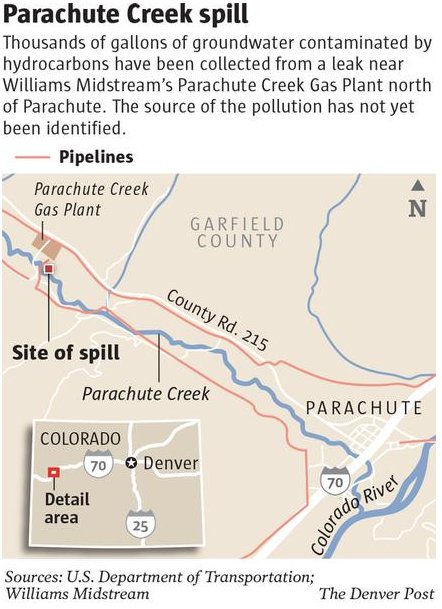
The contamination was first discovered March 8. The site is about four miles northwest of Parachute.
From The Grand Junction Daily Sentinel (Dennis Webb):
Workers excavated under a valve box Friday that has been a focus of an ongoing investigation into the source of a liquid hydrocarbons leak near Parachute Creek northwest of Parachute.
Crews also continued work on hand-drilling a new set of monitoring wells, a day after the Colorado Department of Natural Resources said three monitoring wells about 30 feet from the creek showed high levels of benzene in groundwater. Additional wells are now being drilled within 10 feet of the creek. So far, creek water samples show no sign of contamination, authorities say.
Some 6,000 gallons of hydrocarbons have been recovered in a pipeline corridor about 50 feet from the creek.
The investigation has begun to focus on the valve box, which is for a 4-inch-diameter pipeline carrying natural gas liquids away from the nearby Parachute Creek Gas Plant, owned by Williams.
Colorado Oil and Gas Conservation Commission staff believe the creek recharges nearby groundwater, rather than vice versa, which is helping protect the creek from contamination.
Bob Arrington, a retired engineer in nearby Battlement Mesa and an oil and gas activist, wrote Thursday on the blog of fellow activist Peggy Tibbetts of Silt, voicing concerns over the commission’s theory. He worries that the trench traps being used will allow benzene and other toxins to flow with the balance of groundwater unless the traps go to the bottom of the aquifer. “This newest evaluation does not improve the situation, if anything it makes it worse as plume routing spreads and becomes harder to trace,” he wrote.
On Friday, a conservation group raised the situation on Parachute Creek in criticizing Gov. John Hickenlooper. In a statement, Clean Water Action pointed to the leak and to Hickenlooper’s visit to tar sands operations in Canada this week. “Instead of touring one of the world’s dirtiest sources of energy in Canada, Gov. Hickenlooper needs to get back to Colorado and take care of business here and ensure the public health is protected. It’s time for the governor to stop pretending all is well with the oil and gas industry and force it to operate in a transparent and accountable way,” the group said.
From The Denver Post:
Benzene is polluting groundwater near a plume of hydrocarbons leaking from the Williams Midstream natural gas plant north of Parachute, in some places 3,600 times greater than the level considered safe for drinking, the state Oil and Gas Conservation Commission reported Thursday. Samples of water from nearby Parachute Creek — a source of water for the town and irrigators — have shown no evidence of contamination, COGCC said. Tests of water from three monitoring wells, about 30 feet from the creek, showed benzene levels ranging from 5,800 parts per billion to 18,000 ppb in a well closest to a trench dug to recover fouled water and oil. The state health standard is 5 ppb…
Hydrological consultants for plant operators Tulsa-based WPX and Williams have analyzed groundwater flow in the area and determined that groundwater is recharged by the creek, rather than groundwater feeding the creek. However, company workers are drilling another set of test wells about 10 feet from Parachute Creek to confirm the pollution is not moving toward the stream…
COGCC said the water being pumped from the recovery trench is “enhancing groundwater flow away from Parachute Creek.”[…]
Since the spill was reported, company workers have been excavating to determine its origin. Earlier this week, the company reported a valve box for a pipeline carrying natural gas liquids away from the plant may be the source.
From Aspen Journalism (Brent Gardner-Smith):
The director of the Colorado Oil and Gas Conservation Commission sought to reassure Pitkin County commissioners on Wednesday that appropriate actions were being taken to contain, and find the source of, a mysterious plume of hydrocarbons threatening Parachute Creek. “They are taking appropriate response actions to identify the source of the release, to clean it up, to keep it from reaching Parachute Creek if at all possible, and hopefully taking actions in the future to prevent similar incidents,” said Matt Lepore, the director of the COGCC, about the two companies involved in the incident — Williams and WPX Energy, a former Williams subsidiary that owns the land where the leak was found.
The location of the plume of liquid hydrocarbons, which the EPA has referred to as “oil,” is 4 miles northwest of the town of Parachute. The plume is 50 feet from Parachute Creek at a point 5 miles above its confluence with the Colorado River…
Commissioner Michael Owsley told Lepore, who was in Pitkin County to talk with local officials, that it sounded as if Williams and WPX were “self-regulating” themselves in handling the incident. “I can’t agree with that commissioner,” Lepore responded. “They are not self-regulating, they are under an order from COGCC to respond to the incident and to clean it up. And they are also working under an order from EPA to respond and clean it up.”
Lepore said the COGCC is the lead regulatory agency on the incident and has had either an environmental protection specialist or an engineer on the site every day since March 15, except for two days. He said a “level of decision making” has been left to the companies, but the COGCC is reviewing those decisions. “We know what decisions they’ve made and we review those to determine, in our view, whether what they are doing is adequate,” Lepore told the commissioners. “And if it’s not, we direct them to do other things.”
“Why hasn’t it been fixed?” Owsley asked about the plume.
“Well, to fix a release, you need to know where it is coming from,” Lepore said.
In an interview after the meeting, Lepore said crews from Williams have inspected two pipelines in the area, a 30-inch line bringing natural gas products to the processing plant, and a 4-inch line leading away from the plant.
Crews dug up 130 feet of the 30-inch line and found nothing wrong. They ran a pressure test on the 4-inch line and found it to be intact. Natural gas wells in the area of the plume also have been pressure-tested and show no signs of anything amiss, Lepore said…
On Wednesday, work was focused on a “valve box” connected to the 4-inch line running from the processing plant, as the soil around the valve box was found to be saturated with hydrocarbons. Special crews trained in handling hazardous materials had to be called in to dig up the saturated soils. Lepore said officials are using the relatively generic term “hydrocarbons” to describe the substance of the plume because the exact substance has yet to be identified…
Documents, maps and photos describing the incident are being posted on the COGCC’s website. From the home page, click on “images” and then select “projects” from the “type” drop-down menu. Then type in the project number, which is 2120. Then hit search.
From The Grand Junction Daily Sentinel (Dennis Webb):
An investigation into a hydrocarbon leak northwest of Parachute is focusing on a valve box for a 4-inch-diameter natural gas liquids line, the director of the Colorado Oil and Gas Conservation Commission said Monday. “The soil around that valve box is fairly saturated with hydrocarbons,” Matt Lepore told commissioner members at their meeting in Denver.
The line leaves Williams’ nearby Parachute Creek Gas Plant, which removes a mix of propane, butane, ethane and other liquids from raw natural gas produced in the region.
An investigation has been continuing into the source of some 6,000 gallons of an unidentified hydrocarbon liquid that Williams discovered after doing pipeline location work in preparation for building an additional plant at the same facility. Lepore said when excavation began around the valve box as part of the continuing investigation, “they called a halt to the work because of the odors present in the area.”
“They wanted to bring in air monitoring equipment and/or respirators for the workers to be equipped with before they continued the investigation,” he said.
Michele Swaner, a Williams spokeswoman, said work around the valve box had resumed by Monday. “It’s accurate to say that we’re certainly looking in that area as a potential source,” she said. But she said the work is part of Williams’ plan to look at all potential sources.
Lepore said crews have excavated around a 30-inch-diameter raw gas pipeline in the area of the valve box but have found no signs of it having leaked. The pipeline leads to the gas plant.
Lepore also confirmed what WPX Energy has said — that testing of gas pressures involving the cement seals around wells it has in the area shows the wells appear to be sound.
Because both Williams and WPX have infrastructure near the leak site, COGCC staff have issued notices of alleged violation against each of them as the investigation into the leak’s cause continues.
The leak is just 50 feet from Parachute Creek, but authorities say there hasn’t been any sign of the creek having become contaminated. The leak has come in contact with shallow groundwater. Lepore said Williams has been installing groundwater monitoring wells between an interception trench and the creek, and test results are being awaited.
Leslie Robinson, chair of the Grand Valley Citizens Alliance, said she feels agencies still need to be more forthcoming about the investigation. “We’ve got to have some lines of communication with the public and I just don’t see it there except for (through) the media,” she said.
From The Denver Post:
Oil company workers investigating a weeks-old spill along Parachute Creek are focused on a valve box on a pipeline carrying natural gas liquids away from the Williams Midstream gas plant, the Colorado Oil and Gas Conservation Commission said Tuesday…
“The soil around the valve box is saturated with hydrocarbons,” the commission reported Tuesday. “Williams continues to conduct cautious investigation in an active pipeline environment.” COGCC said the gas company has collected tainted groundwater in trenches, though no measurable amounts of hydrocarbons have been collected since last week, when the total was logged at about 6,000 gallons of oil. The company also collected more than 60,000 gallons of contaminated water.
More oil and gas coverage here and here.