I hope you are enjoying the day with friends and family. Remember — You are what you eat!

I hope you are enjoying the day with friends and family. Remember — You are what you eat!
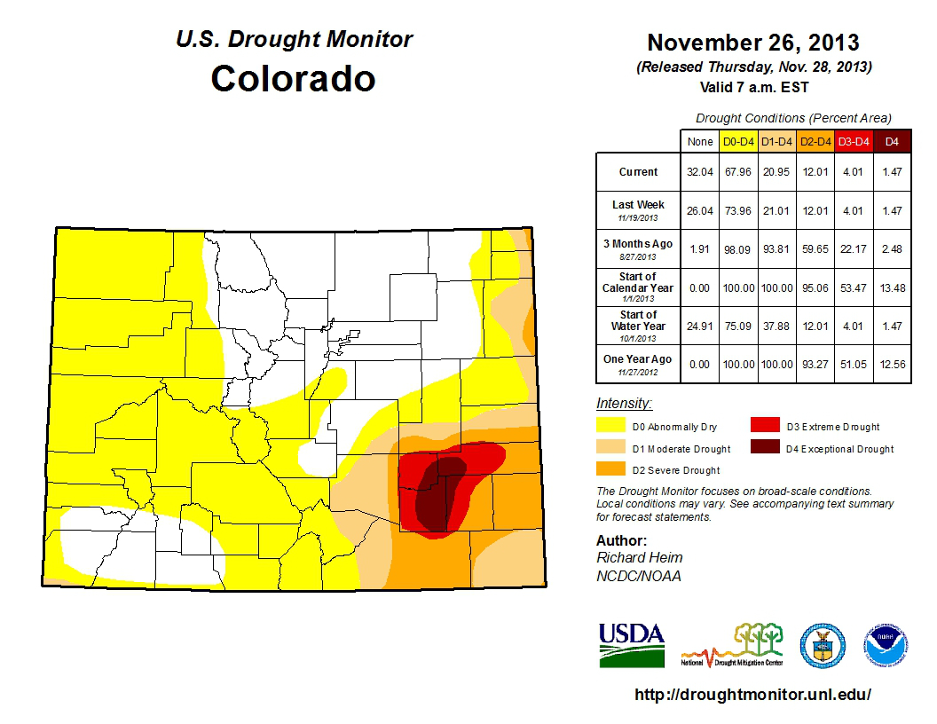
Click here to read the November 26, 2013 assessment. Click here go to the NIDIS website hosted by the Colorado Climate Center.


Click here to go to the US Drought Monitor Website. Here’s an excerpt:
Midwest and Plains
An inch or more of precipitation fell across parts of the Midwest, locally in southern Iowa, southern Illinois, and parts of Missouri. D1 was trimmed slightly in northern Missouri. Although a few half-inch precipitation reports were received, most stations in northeast Kansas were much drier this week, compounding longer-term (month-to-date and 6-12 month) departures, so D0 was extended across northeast Kansas and slightly in northwest Missouri.
The West
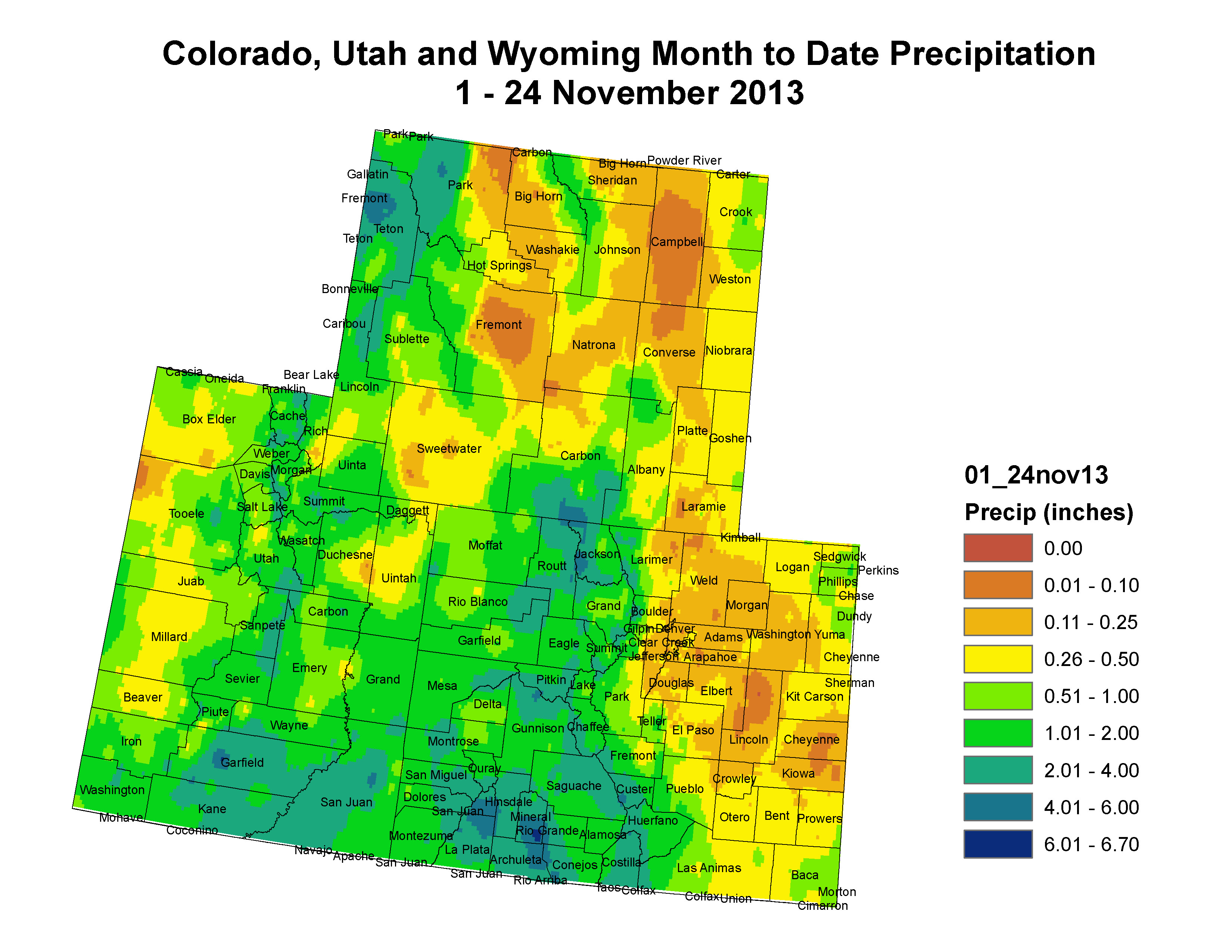
A slow-moving upper-level low pressure system brought rain and winter weather to the west coast and Southwest. An inch or more of precipitation fell from coastal Oregon through California, and northwestern New Mexico, with locally heavier amounts. Widespread 2+ inches of precipitation fell over Arizona, southern Nevada, southern Utah, and southwest Colorado, with 4 inches or more in central Arizona. D1 and D2 were pulled back in southern California and D1 was pulled back in southern Utah. D0 was pulled back in southwest Colorado. D1 and D2 were trimmed in northern New Mexico, with the improvements tempered by low reservoir conditions in the northwest. D0-D1 were pulled back in Arizona, especially in the central sections, and D2 was trimmed in the south. With the much-above-normal precipitation this week in Arizona and parts of southern California, the SL impacts area was shifted over to the central half of California.
Looking Ahead
As the low pressure system and cold front move up the east coast during the next couple days, they will generate widespread rain and snow. The NWS HPC 7-Day Quantitative Precipitation Forecast (QPF) has 1+ inches of precipitation from the Carolinas to the Northeast, with locally 3+ inches in the Northeast, through December 4. It also calls for an inch or more of precipitation in the Cascades and northern Rockies, half an inch along the Gulf of Mexico coast, a tenth of an inch or less for the Midwest and Plains, and a dry reprieve (no precipitation) for the Southwest. Temperatures are predicted to average above normal in the West and below normal in the East. The 6-10 day and 8-14 day outlooks project above-normal temperatures across the southeastern third of the country, and much of Alaska, for December 4-10, and below-normal temperatures in the Alaskan panhandle and much of the West and Plains, with the below-normal temperatures progressing eastward into the Great Lakes near the end of the period. Above-normal precipitation is expected across most of the West, due to a series of Pacific weather systems, and to the Lower Mississippi Valley then much of the East, due to a series of Gulf of Mexico weather systems. Below-normal precipitation is projected for the Plains, coastal Northwest, and much of Alaska.
Here’s the November 2013 Drought Update from the Colorado Water Conservation Board:
Continued precipitation across much of the state has led to significant improvements in most of Colorado. However the Arkansas basin is still experiencing exceptional, D4, drought conditions. Storage levels are strong and better than they were this time last year, easing concerns of municipal providers. Early season snow has been decent, but long range forecasts paint an unclear picture as to what we can expect throughout the winter months. Consequently, activation of the state drought plan remains in effect.
Strong and persistent fall rains coupled with a good start to the snow accumulation season has resulted in large improvements to the US Drought Monitor for Colorado. Currently, 74% of the state is in some level of classification on the US drought monitor. However 53% of that is characterized as “abnormally dry” while an additional 9% is experiencing D1 or moderate drought conditions. Only 8% is classified as severe, 2.5% as extreme and only 1.47% of the state remains in exceptional drought. In comparison, three months ago 25% of the state was experiencing extreme and exceptional (D3 and D4) drought, while at the start of the calendar year 53% was classified as D3 or D4. A cool October followed by a warm start to November has resulted in water year to-date (water year 2014 began Oct 1, 2013 and will run through September 2014) temperatures that are slightly below normal. The latest Climate Prediction Center forecast shows the probability for warmer temperatures through December across much of the state. September and October precipitation were both well above average statewide. Currently, water year to-date precipitation is 107% of average with the northern part of the state near average to above average (99-140%) and the basins of the southwest, Rio Grande and Arkansas ranging from 83-88%. Reservoir storage as of November 1st has rebounded to 83% of average statewide. Many providers were able to store substantial amounts of water during the September rain events. Denver Water, the state’s largest water provider, was able to store water in September for the first time in their history. Consequently, areas of the state that have received the most beneficial precipitation are also showing the higher reservoir storage levels. The Yampa/ White remains the highest storage levels in the state at 112% of average; while the South Platte and the Upper Colorado are reporting storage levels of 107 and 91% respectively. The southern portion of the state has lower storage levels at 72, 68 and 67% of average in the Arkansas, Gunnison and Southwest basins respectively. The Rio Grande continues to have the lowest storage levels in the state at 47% of average. The Climate Prediction Center seasonal drought outlook released November 21, 2013 and valid for November 21-February 28, 2014 illustrates persistent drought across southeastern Colorado and the eastern plains along the Kansas and Nebraska boarder. Temperature forecasts for the same period show an equal chance of being above and below average. ENSO conditions remain neutral, which offers less guidance for long range climate outlooks. However, early season snow in the mountains is consistent with the snowpack forecast for January 1st that is near or above average in all basins. The statistical precipitation forecast for January- March 2014 shows dryness across much of the state, but has had limited operational skill since 2000.
Click here to read the newsletter.

From the High Country News (Sarah Jane Keller):
The runoff season is never as predictable as anyone would like, but in the last decade or so there’s been a new wild card that makes the snowpack’s bounty seem even more capricious – spring dust storms.
Southwest Colorado’s snowpack is the West’s hardest-hit when spring winds carrying tiny dust particles slam into the mountains. That cinnamon layer coating the snow means that it absorbs more of the sun’s radiation, heats up, and melts faster than clean snow (it’s the black t-shirt versus white t-shirt effect). As water managers in the Colorado Basin plan for the region’s impending water crunch, and more dust is blowing around the West, they are starting to realize that dust is a hydrological game-changer.
The Center for Snow and Avalanche Studies, in Silverton, Colo., began tracking dust on snow in the San Juan Mountains in 2003, but dust has been worse in recent years, including 2013. In a recent study looking at the combined impact of climate warming and dust on the Upper Colorado River Basin’s snowpack, researchers found that “extreme” dust years like 2009 and 2010 advance spring runoff timing by three weeks, compared to moderate dust years. That’s a total of six weeks earlier than runoff from clean snow.
That doesn’t bode well for water users or for ecosystems. Normally, snow doles out water gradually over the spring and early summer, but when dust spurs snow into early melt-out, that gives soils a head start on drying out in the summer and irrigators are more likely to end up water-short later in the season.
That result adds more detail to what earlier research has shown – that at least in the short term, dust has a bigger impact on the speed of mountain snow melt than increasing temperatures do. While the new study was based on a model covering the Upper Colorado River Basin, at a snow monitoring site on Red Mountain Pass near Telluride, dust from the 2009 and 2010 storms advanced melt by 50 and 43 days compared to a clean snowpack. “It’s as if somehow you had magically added two to four degrees Celsius to the temperatures we experienced during those years,” says Chris Landry, the executive director of the Center for Snow and Avalanche Studies.
Dirty snow also impacts the amount of water the mountains provide, because it leaves soil and plants exposed longer, allowing water more time to evaporate…
By using satellite images and matching the chemical signatures of dust on snow back to its original landscape, dust gurus have figured out that winds are picking soil up from disturbed desert areas in Arizona, Utah and New Mexico (and increasing aridity isn’t helping). Most of that is coming from the Colorado Plateau, and Milford Flat – the site of Utah’s largest wildfire – is a chronic contributor, according to Jayne Belnap, an ecologist with the U.S. Geologic Survey in Moab, who was involved in the recent study.
The problem with tracking dust sources is that the big contributors like Milford Flat are easy enough to see in satellite imagery, but the small and medium ones, like dusty dirt roads, abandoned housing developments, or overgrazing, are harder to pinpoint. It takes many years of data, which Belnap doesn’t have yet, to say “grazing does this, and roads do that.”[…]
But she thinks they do know enough about certain areas to start restoring loose soil now. People think of deserts as dust and sand, but when they are healthy, they are stable, and their soils don’t tend to blow away.
Beating back dust ultimately comes down to the slogan found on National Park signs around the Southwest: “Don’t Bust the Crust.” That refers to the cryptobiotic soil crust that Belknap studies and that anchors the desert ecosystem, and its soil, in place. “The obvious thing is to stop disturbing it, of course, but we have the problem of the West being the bull’s-eye for energy, wind, solar, and everything else,” she says.[…]
It’s hard to quantify how much it would reduce the overall dust problem, but since it will lock out soil-disrupting motorized use and energy development, a massive, contentious wilderness deal being negotiated in Utah right now could have “huge implications” for minimizing dust,” Belnap says. But the deal won’t solve all of our dust problems. And regardless of the policy for managing arid landscapes, she says, “we just need to take dust seriously.”
Before saying something, ask yourself: Is it kind? Is it necessary? Does it improve upon the silence? – Quaker advice
— John Perry Barlow (@JPBarlow) November 28, 2013

From Colorado Public News (David O. Williams/Dale Rodebaugh) via The Durango Herald:
“The fracking ban votes reflect the genuine anxiety and concern of having an industrial process close to neighborhoods,” Hickenlooper said recently in a prepared statement. The statement came after a tally of final votes showed residents in Broomfield successfully passed a fourth so-called “fracking ban” in Colorado.
Fort Collins, Boulder and Lafayette voters passed similar bans by much wider margins earlier this month, but Broomfield’s vote was so close (10,350 to 10,333) that it has triggered an automatic recount.
Christi Zeller, director of the La Plata County Energy Council, said the votes in Boulder and Lafayette are symbolic. Boulder County has some production, but the city of Boulder’s last gas well was plugged in 1999, she said.
“The bans are an emotional response,” Zeller said. “A lot of professional agitators are manipulating people’s response.”[…]
Hickenlooper said mineral rights need to be protected and that the four communities can work with the state’s chief regulatory agency, the Colorado Oil and Gas Conservation Commission, to mitigate environmental and health concerns.
“Local fracking bans essentially deprive people of their legal rights to access the property they own. Our state Constitution protects these rights,” the governor said. “A framework exists for local communities to work collaboratively with state regulators and the energy industry. We all share the same desire of keeping communities safe.”
But Dan Randolph, director of the San Juan Citizens Alliance, said that Hickenlooper, as a former gas and oil industry employee, doesn’t get it.
Randolph said there are legitimate concerns tied to gas and oil production. He cited health, water quality and noise.
“There is no question that there is an increase of volatile organic compounds in the air during gas and gas development,” Randolph said. “There are and have been serious concerns elsewhere. This is not unique to Colorado.
“He should talk to the people who approved the bans, not the people who oppose them,” Randolph said. “His credibility on oil and gas issues is very low with the general public.”
From the Fort Collins Coloradoan (Ryan Maye Handy):
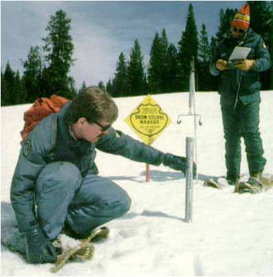
Since the early 1900s, the Natural Resources Conservation Service, or NRCS, has kept records of snow depth and weight to help predict spring runoff — estimates that are crucial to reservoir managers, water conservation districts and farmers across the state. But the budget for the NRCS Snow Survey Program in the West — which spans from New Mexico to Montana and from Colorado to California — has been cut by 15 percent since 2011, forcing the agency to cut staff.
Now, with more budget cuts looming in 2014, NRCS announced in late October that it might eliminate 47 of its 72 Colorado “snow course” sites, where scientists trek to measure snow, some of which have records dating back to 1936.
“The short of it is, the snow program as a whole has taken budget cuts over the past few years, and yeah, I mean those cuts are very real,” said Mage Hultstrand, an assistant snow survey supervisor. “I think this year we are talking another eight percent.”
The decision to abandon more than half of the snow measuring sites inspired a group of 100 water conservation districts and farmers across the state to save them, possibly by paying for monitoring themselves. The Northern Colorado Water Conservancy District, one member of the group, uses 23 of the NRCS snow measuring sites, four of which are on the elimination list, said spokesman Brian Werner…
Since the 1930s, field officers have been measuring snow density across Colorado, and in the 1970s NRCS began the SNOTEL program, which uses equipment, not manpower, to measure snow. SNOTEL updates are hourly and available on the Internet; that crucial aspect of the program will not be cut, no matter what the 2014 federal budget dictates, said B.J. Shoup, a soil scientist with the program…
On Nov. 8, NRCS met with Northern Water and other groups that could be affected by the loss of snow measuring sites. For the briefing, NRCS crunched some numbers and reduced its staff of 42 snow surveyors to 19 so it can continue to monitor the 47 Colorado sites in jeopardy. For 2014, it expects its budget for measuring Colorado sites to be $78,741. The details of a potential arrangement with stakeholders to pay for surveying have not yet been worked out, Hultstrand said.
In the meantime, the Snow Survey Program has tried to trim the fat in other ways. The Colorado office, which monitors Arizona, Colorado, New Mexico, and southern Wyoming, has a staff of six, with two vacant positions, said Hultstrand. The Colorado program hopes that employees of other agencies — like Northern Water, Denver Water or the Colorado Division of Water Resources — can start monitoring the sites at their own cost.
“Those don’t cost us any money in salaries or training,” Hultstrand explained. “That’s kind of what we are hoping to push for our program to be more cooperative. We had some public meetings to discuss this — this data is very important to a lot of people.”
From the Associated Press (Colleen Slevin) via The Pueblo Chieftain:
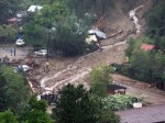
For a few precious hours every Saturday night, Jamestown, in the foothills of the Rockies, looks more like it did before the floods.
Those who stayed after September’s devastation and those who had to leave for rental homes in nearby Boulder return once a week to the Jamestown Mercantile — the town’s meeting place for more than 100 years — to eat together. Then, they push back the tables to dance to live music.
And this fall, as the cleanup and rebuilding continue, the gatherings have been a place to give thanks.
“Everybody just walks through there with the biggest smile on their face,” owner Rainbow Shultz said of “the Merc,” which boasts of having served miners, painted ladies and horse thieves in its early days.
The storm destroyed a fifth of the former mining town’s homes and both bridges over Little James Creek. During the week, federal aid workers outnumber residents and lines of trucks hauling away tons of debris pass down the main street.
Before the flood, finding community was easy in the town of 300, something people say made the town more than just another scenic spot. Residents never hesitated to ask their neighbors for help, and it wasn’t hard to run across someone telling an interesting story.
Karen Zupko, who lost most of her house to the waters, said parties started easily. Whenever she and her neighbor pulled up chairs to a bridge over the creek with some cheese, crackers and something to drink, others were bound to join them.
Jamestown’s children were tight, too, attending classes in a small schoolhouse.
The flood cut off access to the school and split those children up. Six students now attend classes in Boulder, where their parents moved. But the community worked to keep the remaining students in Jamestown together.
For several weeks, 15 students studied in the living and dining room of one student’s home, then moved to a Christian retreat center. A holiday play uniting all the students is one of several programs planned to keep them connected in the coming weeks.
“I feel like they’re growing up with a family of 300 people watching them,” said Shultz, who has lived in town for 12 years and has two children, aged 3 and 6.
Coyote Gulch’s grandfather was born in Jamestown during the early mining days so the town has always been special to me.