
Day: November 12, 2013
Study: Climate science needs to start focusing more on adaptation strategies
Pipeline from the Missouri River to supplement #ColoradoRiver Basin supplies?

Missouri River Reuse Project via The New York Times

Missouri River Basin

Colorado River Basin via Rand JIE
From Circle of Blue (Brett Walton):
“We created the largest artificial watershed in the world,” says Pat Mulroy, the powerful head of the Southern Nevada Water Authority, a wholesaler that supplies Las Vegas.
Water from the Colorado River is piped across deserts, channeled through mountains, and — after being treated in local sewage plants — winds up in rivers that flow to the southern ends of the country:
- Some of New Mexico’s share goes into the Rio Grande, eventually flowing south and east through Texas and into the Gulf of Mexico.
- What Denver returns to nature flows into the South Platte, a tributary of the Missouri River.
- The coastal cities of Southern California dump a good bit of their diversion into the Pacific Ocean.
None of these water bodies is the logical end of the line for the Colorado River, whose natural terminus is a delta at the northern crook of the Gulf of California. A delta that is, ironically, all dried up…
The river’s web, if some have their way, could become even larger. John Kaufman, the man who proposed the Missouri River pipeline, wants to see the artificial boundaries expand. Kaufman is the general manager of Leavenworth Water, which serves 50,000 people in a town that welcomed Lewis and Clark in 1804 during the duo’s westward exploration.
The identity of the pipeline’s proponent, who was anonymous during the Bureau of Reclamation study and is for the first time being named in the media, is important because of where he lives — outside of the natural Colorado River Basin, or in the extended web.
In Kaufman’s vision, Kansas becomes a hydrological keystone for the West, facilitating water transfers that could affect at least 10 states and Mexico.
“We’d hopscotch water across Kansas and sell it to communities in the state,” Kaufman told me during a phone interview last month, explaining the benefit to his home territory. Construction of the pipeline would also supply jobs to Leavenworth, where the intake facilities would be located. At least one groundwater district in western Kansas is advocating for a similar concept, a Missouri River pipeline to the High Plains to compensate for declines in the Ogallala Aquifer, an essential source for irrigation. Kaufman has presented his idea to state and local officials several times this year.
Once the water flows past Kansas, “it’s a horse trade,” Kaufman said. Water delivered to the Front Range would be earmarked for the South Platte River Basin, which includes Denver. (The South Platte, remember, is part of the Missouri River Basin.) A pipeline would close the circle, sending South Platte water, via the Missouri, back uphill. Of course a few drops of the Colorado would be in the pipe, too.
“It’s a reuse project, really,” said Kaufman, who serves on Kansas governor Sam Brownback’s Missouri River advisory committee…
Then there are the swaps. Front Range cities get roughly 72 percent of their supplies from the Colorado River, according to a 2009 study commissioned by the Front Range Water Council. If water from the Missouri were imported, then some of the trans-Rocky diversions could remain within the Colorado River Basin.
Kaufman’s idea — he calls it the Eisenhower Pipeline, in honor of the sponsor of the interstate highway system, which got its start in Kansas — was included in the Bureau of Reclamation’s final report, but top federal officials distanced themselves from the project, once word leaked a few days before the report’s official release last December.
“In my view, [water import] solutions are impractical and not feasible,” said Ken Salazar, Secretary of the Interior at the time. The study actually gave the pipeline high marks for technical feasibility, but the $US 8.6 billion price tag and the high energy costs pushed the pipeline to the bottom of the pile. Conservation was the big winner, deemed to be significantly cheaper and able to deliver more water.
Kaufman knows the scheme is expensive, which is why he says that he needs financial buy-in from the states in the Colorado’s Lower Basin and cooperative agreements among all the Basin states in order to shuffle water supplies.
“It’s not about providing water to the Front Range,” he said. “It’s about providing water to the West.”
The Intermountain West Climate Dashboard update from Western Water Assessment is now available
Click here to go to the website. Scroll down for all the information. Here’s an excerpt:
Latest Monthly Briefing – November 11, 2013
Highlights
Above-average October precipitation in Wyoming and northern and western Colorado further alleviated drought conditions and provided a good start to the winter snowpack.
Precipitation was below-average in Utah and southern and eastern Colorado, though cool temperatures across the region in October helped retain the snow that did fall.
The NOAA CPC climate outlooks show a tilt towards continued wet conditions for Wyoming into the winter months, with no tilt for the rest of the region.
October Precipitation and Temperatures, and Current Drought
In October, storm tracks favored the Northern Plains and left nearly all of Wyoming with above-normal precipitation; much of the state was over 200% of normal. To the south, this wet anomaly extended into northern Colorado and far western Colorado, and a portion of eastern Utah. The rest of Colorado and Utah saw drier-than-normal conditions, including persistently drought-stricken southeastern Colorado.
After the relatively dry conditions during the first 10 days of November, the current HPRCC Water Year Precipitation map for 2014 shows essentially the same pattern as for the month of October.
October’s temperatures were cooler than average across the region—and across the entire western US—even in those areas with below-average precipitationWestern US Seasonal Precipitation. Most areas were 2–6°F below average monthly temperatures for October, which helped keep the new snow in the mountains on the ground.
The latest US Drought Monitor, representing conditions as of November 5 Modeled Soil Saturation Index, shows further improvement in the persistent drought conditions over the past month. The most significant improvements were in southern and eastern Wyoming, where D2 and D3 drought conditions on October 1 improved to D0 and D1. Lesser improvements occurred in south-central and northwestern Colorado. The proportion of Wyoming in D2 or worse drought dropped to zero, from 22% on October 1; Utah remained at 16%; and Colorado remained at 12%. Region-wide, the overall drought extent and severity is now lower than it has been since early 2012.
Snowpack
The Current Basin Snowpack map from NRCS Western US Seasonal Precipitation indicates near- to above-average SWE in all but a handful of basins in our region, with the largest positive anomalies in Wyoming, southern Utah, and northwestern Colorado. We are still very early in the snowpack season, and the % of average SWE values are more volatile than later in the season. With average to dry conditions forecasted for the region for the next 5 to 14 days, these values may slip backwards by late November, especially in Utah and much of Colorado where the actual SWE amounts on the ground are generally less than 2″.
Current Streamflows
The maps of current streamflows for Colorado Map of flood and high flow condition (Missouri), Utah Map of real-time streamflow compared to historical streamflow for the day of the year (Missouri), and Wyoming Stream Gauge Map show that streams in the region are generally in lower flow categories than one month ago, but most are still in the normal or above-normal categories. The Colorado River near the CO-UT state line was in the 40th percentile (96% of median flow) on November 9.
Seasonal Climate and Drought Forecasts
The latest monthly Climate Outlook released on October 31 by NOAA CPC shows a slight dry tilt for precipitation for November, 0.5-mo lead extending into extreme southern Colorado, but no tilt elsewhere. The seasonal outlooks released October 17 show a tilt towards wetter conditions for most of Wyoming, but no tilt elsewhere in the region, for the November–January period 3-mo precip forecast, 0.5-mo lead, and no tilt for the December–February period 3-mo precip forecast, 0.5-mo lead. The latest CPC Seasonal Drought Outlook released October 17 projects that the remaining areas of drought conditions (D1 or worse) in our region, mainly in Utah, will persist through at least January Stream Gauge Map.
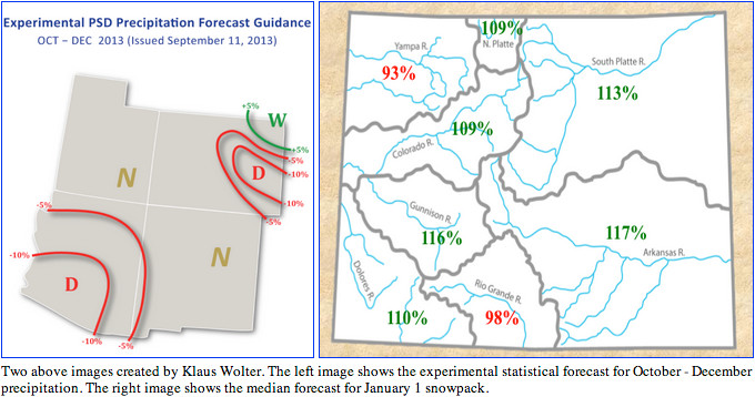
As reported in the October 8 briefing, the PSD Precipitation Forecast Guidance released September 11 for October–December 2013 conditions shows a slight wet tilt for the period for far northeastern Colorado, and a dry tilt for most of eastern Colorado into the northern Front Range. No tilt is forecasted for the rest of Colorado and Utah, indicating equal chances for wet, dry, and middle outcomes. The fall-early winter period historically has shown the least forecast skill of all seasons, though there has been positive skill east of the Continental Divide.
Also reported in the October 8 briefing: in the experimental January 1 SWE forecast for Colorado released in early October, the median (50th percentile) forecast Experimental Precipitation Forecast Guidance calls for above-average January 1 snowpack (109–117% of average) for all basins except the Yampa (93%) and Rio Grande (98%).
ENSO indicators Stream Gauge MapMap of real-time streamflow compared to historical streamflow for the day of the year (Missouri) are still showing ENSO-neutral conditions, though with a warming trend over the past few months. The models in IRI’s mid-October ENSO Prediction Plume Map of real-time streamflow compared to historical streamflow for the day of the year once again indicate a consensus towards ENSO-neutral conditions continuing through the winter, though now both the dynamical and statistical models are tending towards the warm side of neutral, with a few models sneaking into El Niño territory by spring.
DARCA Annual Convention scheduled for February 26-28, 2014

From email from DARCA (John McKenzie):
DARCA will be hosting its 12th Annual Convention on February 26-28, 2014. The convention will be held at the Plaza Event Center in Longmont, Colorado, 1850 Industrial Circle, Longmont, CO 80501.
During the three day conference, a wide variety of speakers will discuss their views on timely subjects facing ditch and reservoir companies. This year’s conference is entitled: From Drought to Deluge- Dealing with Uncertainty. The speakers will be addressing flood and recovery issues along the Front Range along with other topics. There will also be three concurrent workshops on the final day of the conference: 1) Water Accounting for Ditch Companies (1/2 day); 2) Conserved Water Statutes – DARCA’s Role (1/2 day); and 3) Information Technologies for Ditch Companies – Web Pages, Excel, and GIS (full day).
You may find of particular interest the pre-convention workshop on Wednesday, February 26, also at the Plaza Event Center. The workshop, Creating Efficiencies and Reducing Transaction Costs for Ditch Companies, will explore how ditch companies can increase their financial viability in today’s complex world.
For information regarding the convention as well as sponsorship or exhibitor opportunities please contact DARCA at (970) 412-1960 or john.mckenzie@darca.org.
2013 Yampa Basin Water Forum recap

From Steamboat Today (Michael Schrantz):
At the Community Alliance of the Yampa Valley’s 2013 Yampa Basin Water Forum, [Diane Mitsch Bush] and fellow presenters Kent Vertrees, Kevin McBride and Jay Gallagher talked through the issues and challenges ahead for the state as it races to meet the December 2014 deadline set out by Gov. John Hickenlooper’s executive order for a state water plan draft. Vertrees is a member of the Yampa/White Basin Roundtable, Gallagher represents the Yampa-White River Basin on the Colorado Water Conservation Board, McBride is on the board of the 2013 Colorado Water Congress, and Mitsch Bush serves on state house committees that oversee water issues. All four represent the interests of the Yampa River Basin in the complicated confluence of water and policy.
Their presentation Monday night at Bud Werner Memorial Library briefed attendees on geology, hydrology and water law as it applies to the Yampa River and Colorado.
The Yampa River, being largely a wild river with a natural hydrograph, is an anomaly among Colorado rivers, and as multiple members of the panel pointed out, that gives the basin a chance to buck the constraints of other basins across the state.
The amount of water in the Yampa River Basin is large compared to other basins, McBride said…
There’s pieces of Colorado water law that would push the Yampa toward developing the same constraints faced in the South Platte River Basin, McBride said, but there’s also opportunity to do something different.
There are many constraints on the future water plan outlined in the presentation, such as highly variable annual flows, climate change, existing water laws and interstate and international agreements, local control and balancing the impact on existing uses and future growth.
There are interests on the Front Range that would look to the Yampa as a reservoir for their needs, Mitsch Bush said, and if consensus can’t be reached with them, the Western Slope will have to stand by its interests…
“Here in Northwest Colorado, we can have that wild river in some ways,” Vertrees said about the best case scenario from the state water plan. “We can have smart storage. We can continue to provide for agriculture needs.”