Click here to read the current assessment. Click here to go to the website.

Click here to read the current assessment. Click here to go to the website.
From The Grand Junction Daily Sentinel (Dennis Webb):
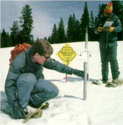
The Natural Resources Conservation Service says it has dropped consideration of reducing the number of Colorado snow survey sites this winter, an idea that had been driven by budget cuts. The idea had drawn criticism from water managers and from U.S. Sens. Mark Udall and Michael Bennet, D-Colo., and U.S. Rep. Scott Tipton, R-Cortez.
Phyllis Ann Philipps, state conservationist in Colorado for the NRCS, told water interests in an Oct. 22 letter that it might be necessary to reduce the number of manual “snow course” measurement sites in the state, following a 15 percent reduction to the agency’s Snow Survey Program for the 2013 fiscal year and anticipated further budget restrictions due to sequestration. Automated sites using telemetry “will be maintained,” she said in the letter, which invited interested parties to an Oct. 28 public meeting on the issue.
“We’re going to continue the manual snow course measurements as recommended by the public forum,” William Shoup, acting snow survey supervisor in Colorado for the NRCS, said Tuesday.
He said the agency would detail its decision in another meeting Thursday.
Chris Treese, external affairs director for the Colorado River District, said that through congressional offices and other voices, “the message has been communicated and the NRCS and the (U.S. Department of Agriculture) are convinced that this isn’t the place that they need to cut.”
Udall spokesman Mike Saccone said Tuesday his office hadn’t been able to confirm the agency’s decision to back off the idea, but if it’s the case it’s welcome news. “Water is critically important to our water providers and certainly those managers on the Western Slope. … If true, this is a big victory for the Western Slope and the people of Colorado,” he said.
Udall, Bennet and Tipton jointly signed a letter to the Department of Agriculture Friday calling on the department and NRCS to make the manual sites a budget priority.
“In the face of prolonged drought, significant population growth and climate change, NRCS’ snow program data provides vital information on precipitation and future water supplies essential for Colorado and the entire American West,” their letter said.
They said snowpack can vary widely from basin to basin, and accurate measurements in each basin using both automated and manual data are “essential for water districts and municipalities to meet the demands of competing users.”
They also said the automated sites “can often face mechanical failure mid-winter, leaving the manual snow courses as the only sources of reliable data to meet local demands and interstate compact deliveries.”
The program has 104 manual snow survey sites in Colorado. Treese said some sit alongside automated sites and are used to double-check the automated operations and adjust or maintain them as needed. Some manual sites have been used for many decades.
“We wouldn’t want to lose that longevity, that time series of information,” he said.
Treese said the snowpack data help water managers plan for spring runoff and have reservoirs release or hold on to water depending on anticipated inflow. It aids in fulfilling water rights obligations and in managing river levels for purposes such as flood avoidance and helping endangered fish.
Shoup said the reduction in manual sites never reached the point of being a proposal by the NRCS. It simply was brought forward for discussion given the budget situation and the fact that data from some of the manual sites isn’t being used in water supply forecasting by the agency’s National Water and Climate Center in Portland, Ore., he said.
But he agreed about the importance of the long-term, historical data being generated by sites that in some cases date back to the 1800s. Those sites provide important information pertaining long-term climate change and the runoff impacts of dust on snow, he said. “There’s just a lot of different historical records that we find are very important,” he said.
He said he’s found ways to continue data collection from all the sites for less money through changes in how the operation is managed. For example, staff working in data collection at the agency’s Denver office also will be deployed into the field for measurements at Front Range sites, rather than paying NRCS field staff for that work.
Shoup said that while all the manual measurements will continue this year, he can’t speak to future years because it all depends on how much funding NRCS gets from Congress.

From The Denver Post (Kathy Chandler-Henry):
We’re hearing a lot about the Colorado Water Plan these days. What does it mean for our state, and especially for our headwaters counties? Because approximately 80 percent of the state’s water comes from the Western Slope, and about that same percentage of the population lives east of the Continental Divide, we have a vested interest in the plan’s process and outcomes.
Why a water plan? Based on predictions for population doubling by 2030 and growing demands for water throughout the arid West, Gov. John Hickenlooper assumes there is a coming gap between the demand for water and available supply, and has directed his staff to develop a plan for the future.
Five factors that must inform the Colorado Water Plan are: advances in “smart” land use planning and development; unrealistic estimates of water availability (and there really isn’t any “new” water); the interdependence of water in the stream and our lives and livelihoods in the headwaters and Western Slope; the importance of conservation and re-use of water to meeting demand; and the imperative of working together rather than independently throughout our river basins to develop a workable plan.
We’ve learned a lot from the recent decades of growth: Local governments know the cost of sprawl and are increasingly instituting advanced land use planning that reflects our dry climate and water-short conditions. Colorado’s Water Plan should take into account these advances when estimating future demand for water. We don’t have to assume that new development and population distributions will or should mimic the patterns of the past 30 years.
Past estimates of the water available for future growth may be overstated, especially water from the Colorado River Basin. For example, the Bureau of Reclamation announced this year that it will reduce the amount of water released from Lake Powell in 2014 to the lowest annual release since filling Lake Powell in 1968. Estimates of available water must be revisited in the water plan.
The Colorado Water Plan must not require some areas of the state to sacrifice their economy, environment, and quality of life to become the water supply for other parts of the state. Impacts of transmountain water diversion projects can be devastating. In Eagle County, we are hyper-vigilant in protecting our water quality and quantity, agriculture, open space, and water/snow-dependent recreation. We also understand that the Front Range needs water for future growth, and have initiated historic agreements with major Front Range water providers.
The Colorado Water Plan should encourage Front Range local governments to narrow the gap between predicted supply and demand through smart growth practices, conservation, and reuse before looking to other areas for additional supply.
Finally, the current planning process charges water leaders in each river basin with independently defining their basin’s future need for water through a roundtable process. As each roundtable works alone, we run the risk of Front Range roundtables planning on water supply that either doesn’t exist, or that other roundtables have planned for their own local needs.
Perhaps most important, the people of Colorado have a seat at the table if their local elected officials are brought into the water plan process. It is critical that local government land use plans and authority throughout the state be respected. Sessions of the Interbasin Compact Committee should allow for public comment and discussion, and roundtables should encourage dialogue among diverse perspectives. We need an opportunity to understand each other’s views and seek common ground. Only then will Colorado be able to join together in a water plan that addresses our water supply needs.
More Colorado Water Plan coverage here.
From the Colorado River District:
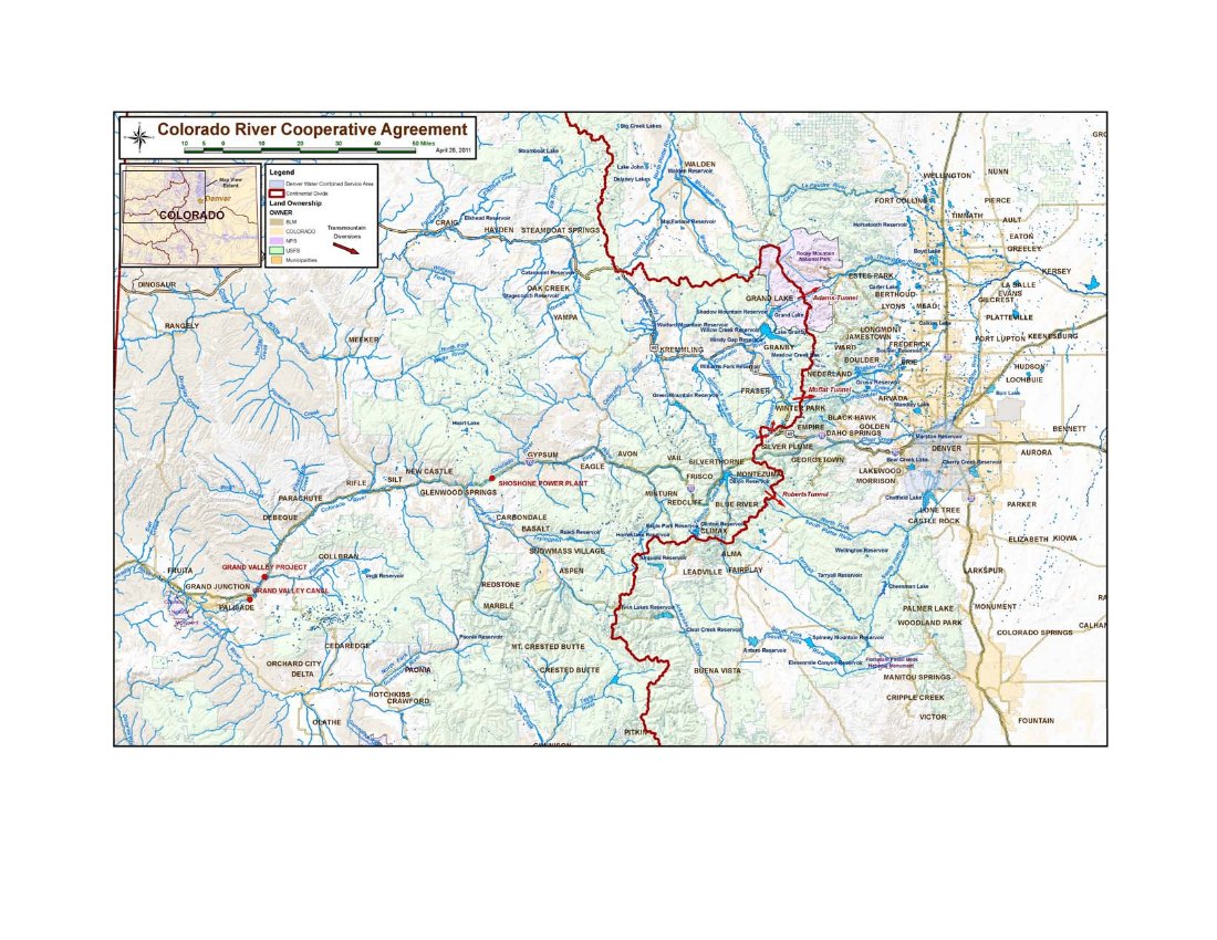
The Colorado River Cooperative Agreement (CRCA) is now fully executed with final approval coming from irrigators and water suppliers in the Grand Valley, General Counsel Peter Fleming reported to the Colorado River District Board of Directors.
The CRCA creates a long-term partnership between Denver Water and 42 entities on the West Slope. The agreement is a framework for numerous actions by the parties to benefit water supply, water quality, recreation and the environment on both sides of the Continental Divide.
It is the direct result of Denver Water’s desire to expand its Moffat Tunnel transmountain water supply from the Fraser River in Grand County and to enlarge Gross Reservoir in Boulder County. While that project is still being permitted, the CRCA represents an enhancement of beneficial actions beyond mitigation yet to be spelled out in the record of decision.
Negotiations on the CRCA concluded in early 2011 and the engaged parties began their approvals. The Grand Valley entities, however, waited until they were satisfied that federal and state reviews of Green Mountain Reservoir and Shoshone Hydro Plant aspects in the agreement were finished and the agreement could be implemented as envisioned.
The CRCA also means the West Slope will not oppose permitting of the Moffat Project. [ed. emphasis mine]
The Colorado River Cooperative Agreement (CRCA) begins a long-term partnership between Denver Water and the West Slope. The agreement is a framework for numerous actions by the parties to benefit water supply, water quality, recreation, and the environment on both sides of the Continental Divide.
More Colorado River Cooperative Agreement coverage here.
Great summary of land use and water conservation workshops hosted by @wradv via @APAColorado1 http://t.co/JssXNw35S3
— Drew Beckwith (@DrewBeckwith) November 20, 2013

From The Pueblo Chieftain (Chris Woodka):
A district committed to keeping water in the Lower Arkansas Valley has joined a network that provides real-time water quality data on the Arkansas River from Leadville to the Kansas state line. The Lower Arkansas Valley Water Conservancy District board Wednesday approved spending $34,000 in the next year to help operate stream gauges and gather information from wells below John Martin Reservoir. The information is widely available on the Internet. The district’s contribution will be matched by $17,000 in federal funds from the U.S. Geological Survey.
“The focus is on the reach from Pueblo to the state line,” said David Mau, head of the Pueblo USGS office.
The Southeastern Colorado Water Conservancy District, Pueblo Board of Water Works and St. Charles Mesa Water District also participate in the program.
Measurements track salinity and temperature of water in the river, as well as groundwater levels. The information provides a baseline that allows water users to track changing water conditions from either natural causes or new uses along the river, Mau said.
Past measurements show salinity increases when water levels are low and as water moves downstream. Crowley County board member Jim Valiant asked if selenium also will be studied. Mau replied that selenium is studied, but not as a part of this project.
Water temperature varies most by the time of year, but can increase when levels are low. Mau said the information is valuable to track fish habitat and to establish the relationship between surface flows and groundwater. Water levels are tracked in 130 wells along the river, some with more than 50 years of data to provide historic comparison.
The board enthusiastically supported the study, and encouraged Mau to provide more frequent updates.
“We need to keep up with the information,” said Leroy Mauch, a board member from Prowers County.
From The Pueblo Chieftain (Chris Woodka):
Ponds that feed irrigation systems in the Lower Arkansas Valley are leaking twice as much as farmers are given credit for, a study is showing. But farmers will have to wait another year for the study to be completed before they can even begin to hope for a change in the state’s formula. In the meantime, those who measure the water coming into and leaving the ponds will be able to apply that to state calculations for replacement of water under surface consumption rules.
The Lower Arkansas Valley Water Conservancy District is sponsoring a two-year study of pond leakage for farmers who use the ponds to collect water for use in sprinkler systems. There are 26 ponds in the study, but there have been problems with the timing of measurements and malfunctioning meters on some of the ponds. The amount of leakage is complicated to measure, depending on the size of ponds, soil conditions, how often the ponds are filled and lag time for water to return to the river, said consultant Brian Lauritsen.
This year, the state’s model showed leakage of about 8 percent on the ponds, while measurements averaged about 18 percent, said Bill Tyner, assistant division engineer for the Colorado Division of Water Resources. Individual ponds ranged from 2-40 percent leakage. “We’re giving credit for any pond with a meter,” Tyner said.
Farmers have joined Rule 10 group plans set up by the Lower Ark district that allow them to account for sprinkler systems fed by surface water supplies. The Lower Ark provides replacement water, but farmers must pay to join and use the plan.
They’re not happy.
“It’s ironic that we go through all these numbers and nitpick them,” said Lamar farmer Dale Mauch. “But no one ever looks at flood ground, and the HI model isn’t even close.”
The Hydrologic-Institutional model was adopted as part of the U.S. Supreme Court case Kansas v. Colorado over the Arkansas River Compact.
From The Pueblo Chieftain (Chris Woodka):
A conservation easement on the Bessemer Ditch will preserve 105 acres in farmland. The Lower Arkansas Valley Water Conservancy District accepted the easement Wednesday. The board uses such easements as part of its mission to keep water in the Lower Ark Valley. It is the custodian for more than 50 easements. Typically, property owners pay for the easement, which undergoes periodic inspections, and are eligible for state and federal tax benefits.
The Bessemer Ditch farm is owned by the Wild Rose Ranch Inc., which is a company formed by the Wally Stealey family. It is located on 43rd Lane and has about 35 shares of Bessemer Ditch water, explained Bill Hancock, who manages conservation programs for the Lower Ark district.
Each share of the Bessemer Ditch provides enough water to irrigate an acre in an average year.
Most of the land is a reclaimed gravel pit or used for pasture land and has not fared well during the drought. An area beneficial to wildlife, Six Mile Creek, crosses the property, Hancock said.
Stealey has donated other easements on the Wild Rose Ranch in Fremont County to the Lower Ark District in the past.
The board voted unanimously to accept the conservation easement.
More Lower Arkansas Valley Water Conservancy District coverage here.