
Another stunning photo from America's public lands. Sandhill cranes sit under a cottonwood – Bosque del Apache NWR. pic.twitter.com/6OA20IhoHP
— US Dept of Interior (@Interior) November 3, 2013
Day: November 3, 2013
John Fleck: The new political economics of moving water

From inkstain (John Fleck):
…it seems clear that the days of federal funding for big projects like this are long over. There are examples of non-federal projects of this scale. Los Angeles has done it. But that’s for municipal water supplies, for which one can charge a lot more.
This 400-Mile “Manmade River” Might Soon Flow Uphill Across Kansas
Colorado budget proposal takes into account recent floods, fires #COflood
Colorado budget proposal takes into account recent floods, fires http://t.co/7FCsvs2MgJ
— Denver Post Breaking (@DenverPostBrk) November 1, 2013
EPA: New map shows percentage dependence on surface water for supply

Click here to visit the webpage. From the introduction:
The health of our nation’s rivers, lakes, bays and coastal waters depends on the vast network of streams and wetlands where they begin. These streams feed downstream waters, trap floodwaters, recharge groundwater supplies, remove pollution, and provide fish and wildlife habitat. Streams and wetlands are also economic drivers because of their key role in providing water and habitat to support fishing, hunting, agriculture and recreation. Approximately 117 million people – one-third of the U.S. population – get some or all of their drinking water from public drinking water systems that rely in part on headwater, seasonal, or rain-dependent streams.
New Methods Improve Quagga and Zebra Mussel Identification

Here’s the release from Reclamation (Peter Soeth):
The earliest possible detection of quagga and zebra mussels has long been a goal of biologists seeking to discover their presence in water bodies. The Bureau of Reclamation’s Detection Laboratory has released two reports identifying a new sampling method to improve the accuracy of quagga and zebra mussel detection while still at the microscopic larval stage. The reports also outline the processes and procedures used to identify invasive mussels through DNA testing.
“Improving the accuracy of testing provides Reclamation and its partners better information about the presence of quagga and zebra mussels in water bodies where our facilities are located,” laboratory manager Denise Hosler said. “These sampling procedures allow for the improved detection when the mussels are in their larval stage.”
For early detection, Reclamation searches samples from reservoirs, lakes, canals and other water bodies for the microscopic larval form of quagga and zebra mussels. Because they are so small, multiple testing methods are used, including cross-polarized light microscopy, scanning electron microscopy and PCR testing of the DNA of larvae in the water sample.
“Early detection of mussel larvae does not mean that the water body will necessarily become infested,” Reclamation’s Director of Research and Development Curt Brown said. “Early detection provides a warning for managers that a water body is being exposed to mussels through some pathway, so they can consider additional means to prevent further introduction.”
Reclamation’s Detection Laboratory is located in the Technical Service Center in Denver. It specializes in invasive mussels and also identifies species through taxonomic and genetic testing. It was awarded the Colorado Governor’s Award for High Impact Research in 2012 for its work advancing the early detection of invasive quagga and zebra mussels.
To download the reports or learn more about Reclamation’s Invasive Mussel Program, please visit http://www.usbr.gov/mussels.
Please remember to clean, drain and dry your watercraft when you are moving it between bodies of water.
Climate: 4th-driest year on record at Lake Powell
51st State Initiative: Whither water rights if secession is successful?
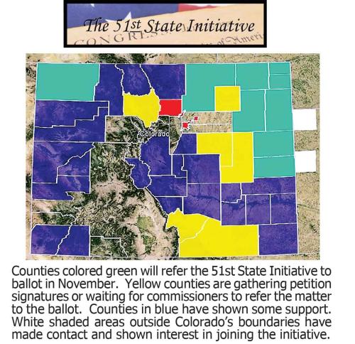
From The Grand Junction Daily Sentinel (Dennis Webb):
Among the questions that surround the idea of Moffat and other Colorado counties seceding from the state, none may be murkier than the one surrounding water rights.
“That would be a tremendous court battle, I’m sure,” said Garfield County Commissioner Mike Samson, also chairman of Associated Governments of Northwest Colorado.
Already, differing opinions abound about what secession might mean when it comes to water. Craig’s City Council unanimously voted against the idea of secession partly after being advised it could create problems for water rights in the county. Moffat County Commissioner John Kinkaid, who led the effort to get the secession question on the county ballot, said those behind the 51st-state movement in Colorado have assured that water rights would remain with their owners even with a change in state.
Said Samson, “You could talk to a dozen different lawyers and get a dozen different opinions as to what would happen.”
Chris Treese, who’s not an attorney but is external affairs director for the Colorado River District, based in Glenwood Springs, warns of significant consequences arising from the Colorado River compact if counties form a new state. Treese said the river compact forbids the use of Colorado River water outside seven basin states and Mexico, the parties to the compact.
Compact concerns led to Rio Blanco County commissioners deciding against pursuing the secession idea even though they share some of the political frustrations that led Moffat commissioners to put the measure on the ballot.
Moffat’s situation is different from eastern Colorado’s, in that Moffat has the Yampa River, part of the Colorado River watershed, flowing through it, Treese said.
“I have no idea how that would have to be handled, but it clearly is something that is not contemplated by the language of the compact,” he said.
Scott Balcomb, a Glenwood Springs water attorney who used to serve as Colorado’s representative to meetings of the seven basin states, isn’t as worried about how such matters would be handled. He said he thinks a new state carved out of Colorado would simply end up with some of Colorado’s water allocation under the compact.
He also thinks existing water rights, including transmountain diversions, would have to be honored if a new state was created, just as existing rights were honored when Colorado and other western states became states.
“(Water) use is a property right and you can’t affect property rights,” he said.
More 51st State Initiative coverage here.
‘…floods are actually good for the health of the rivers’ — Ellen Wohl #COflood
From The Denver Post (Electa Draper:)
Colorado creeks changed lives, cities and landscapes during five days in September, but no transformation was greater than in the creeks themselves.
Dozens of streams charted new courses and claimed new territory — indifferent to the wreckage they left behind or carried along.
The St. Vrain abandoned its channel in at least 10 places between its headwaters above Lyons and its confluence with the South Platte River. Wherever the streambed was too small or too clogged, the rain-swollen creek jumped its banks or tore at them, leaving behind raw, chaotic landscapes.
“We have a new river,” said Sean Cronin, director of the St. Vrain and Left Hand Water Conservancy District. “We’re just now out of initial emergency response and looking at long-term recovery.”
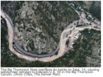
Similar stories of the September floods can be read in each tributary of the South Platte, from Fort Collins to Boulder — the St. Vrain, Big Thompson, Little Thompson, James, Boulder, Fourmile creeks and others.
“Many channels are devastated. I would be hard-pressed to pick the worst loser,” said Deputy State Engineer Scott Cuthbertson with the Colorado Division of Water Resources.
And within reach of each river or stream, people in 14 counties who live, work and govern in these nearly unrecognizable basins are grappling with questions: Who is going to put the stream back where it was? Who is going to pay for it, and how many millions will it cost?
“Who determines the post-flood channel?” was a question even Colorado Water Conservation Board chairman Alan Hamel asked during an all-day meeting Oct. 21 on flood recovery.
“Where the river ends up needs to be a discussion by local communities,” responded river channel expert Chris Sturm, who heads up the Stream Team, a group of consulting experts from the state, Federal Emergency Management Agency and the U.S. Army Corps of Engineers.
“The state will help figure out who could help and where to find money, but we don’t prioritize,” Sturm said.
Yet, he said, when the team has met with local leaders in basin after basin, they seemed to expect the team to have regulatory authority over the streams and their course.
“Maybe they were a little disappointed we weren’t telling them where to put the rivers,” Sturm said.
Who is responsible?
The St. Vrains — north, south and middle forks — converge at the mouth of a canyon near Lyons, and then flow as one St. Vrain a little more than 32 miles through Hygiene and Longmont, under and past Interstate 25, to the South Platte River.
Together, the St. Vrain, and the Left Hand and Boulder creeks that join it, drain the mountains and foothills north and west of Longmont and Boulder.
In the flood, the St. Vrain channel migrated a few yards in some places and a few hundred yards in others. It chewed up highways and county roads and clawed at dirt banks that had held up homes and yards and turned them into towering, sheer and muddy cliffs.
The river destroyed or left high and dry most diversion structures for watering agricultural fields and serving drinking water. It disrupted all utilities in its corridor. Longmont lost four of five water supply lines. Lyons lost all its core infrastructure.
In one day, the flood rendered Longmont’s St. Vrain riverside trail — 20 years in the making — into a path without a river. The St. Vrain just took a new course.
Everywhere in the St. Vrain basin, from Button Rock Dam in the mountains west of Lyons to the city of Longmont, there is the same smell of freshly churned earth, pulverized rock, uprooted trees stripped clean as toothpicks, decomposing vegetation, brackish water, rusting metal and more decay.
“The question is, who is responsible for cleaning this up?” Cuth-bertson said.
Unlike after Hurricane Katrina, the Army Corps of Engineers will not reconstruct Colorado’s unique patchwork of now-fractured water infrastructure. The system was mostly built by private landowners, farmers, ditch companies, water districts, towns and cities. And they will be the ones to rebuild it, Cuthbertson and other state and federal authorities say.
“Everywhere I’ve been,” said Longmont Public Works and Natural Resources Director Dale Rademacher, “people have asked me, ‘When are they going to come fix it?’ They? There is no ‘they.’ No cavalry is coming to make the decisions. It’s us.”
On private property, it’s up to the owners to reclaim what land they can from the creek. They might be working near highway crews, and even National Guard units, reconstructing collapsed roadways.
“Everyone thinks (FEMA) is going to fix everything, as if we have the equipment to do anything,” FEMA Public Assistance expert Chris Thomas said.
FEMA doesn’t put rivers back in “their places.” It provides money to save lives and to give shelter to displaced individuals. It pays to remove flood debris and reduce immediate flood risks. It reimburses local governments for about 75 percent of the costs to repair flood-damaged infrastructure.
“But no one agency is going to come in and pay for everything,” Sturm said. And the puzzle of river restoration, he said, must be solved watershed by watershed.
Fluid, unyielding
Water’s fascination is that, while it’s seemingly fluid and yielding, it carries tremendous force, said Colorado State University geology professor Ellen Wohl . Water in motion is incredibly destructive on its own, but when it picks up cobbles, boulders, wood, cars, houses and other debris, that’s coarse-grained sandpaper on nature’s scale.
When the floodwaters receded, mile after mile of St. Vrain riverbed was left a broad, irregular, mostly waterless plain with mounds of sand, sediment and gravel braided with piles of gray rock and debris.
But that’s the short-term human perspective. Before Colorado was settled, its narrow canyons were river channel from wall to wall. Humans added roads and buildings in these tight spots and confined the channel. In one week in September, the stranglehold of asphalt, concrete and riprap on the St. Vrain was broken.
The river, from an ecosystem perspective, was as creative as it was destructive — new beds and paths, new aquatic life habitat in new pools and riffles and runs.
“No question, it was a disaster for people,” Wohl said, “but floods are actually good for the health of the rivers. They are dynamic systems. We try to make them less so. We create bland rivers.”
One can see, she said, geological evidence of how the rivers have migrated back and forth in the canyons over time.
“What we will wrestle with now is to what degree does the new river need to be embraced and to what degree does that (harm) our economy and way of life,” Rademacher said. “In most places, it’s probably just too costly to embrace the new river.”
Stream Team members say there might still be opportunities for communities and governments to plan together to mitigate future flood risks by leaving more open space around rivers in places where roads don’t dictate the channel. It could be a chance, they said, to reconstruct channels that would maximize the state’s typically low year-round stream flows to better serve aquatic life and recreation.
In many respects, Colorado streams are crowded places. The streambed is part of the private property of individual landowners. Yet stream flow and use is under the administration of the Colorado Division of Water Resources. And any dredging or filling of a stream below the normal high-water line requires a 404 permit from the U.S. Army Corps of Engineers under the Clean Water Act.
And by Colorado statutes, owners of rights to use water also have rights of access to streams over or through others’ private properties to locate their water-diversion structures, Cuthbertson said.
Streambed owners run the gamut from cities such as Boulder and Longmont to individual homeowners and resort operators, and from a small ditch system with a few hobby farmers on a couple hundred acres to big water districts.
“Right now we’re trying to figure out how to work together to restore irrigation and municipal water supplies, get the right voices at the table and keep nimble enough to work with federal agencies,” said David Bell, Boulder County’s manager of agricultural resources.
Where there is a decision to rebuild ruined homes along river channels and floodplains, residents must meet federal standards to remain eligible for the National Flood Insurance Program under FEMA.
Millions in damage
At Lyons, in just one example of challenges ahead, the St. Vrain once flowed under the McConnell Drive Bridge at Colorado 66, on the east side of town. Now there are a few stagnant mud puddles around the bridge instead of a creek.
Not many yards to the west, where a trio of quiet ponds had served as tranquil scenery for the Lyons Valley Park subdivision, the river ripped through them, connecting the ponds as part of its new channel. In the process, it annihilated a section of road running to Lyons Middle/Senior High School.
Longmont, Lyons and Boulder County are working together to fix the intersection. “The plan is to get the river back under the bridge, rather than build a second bridge,” Rademacher said.
The city of Longmont estimates flood repairs and rebuilding will cost it a total of $148 million. Lyons, with a $1 million annual budget, has estimated $50 million in damages, Rademacher said. Lyons was without municipal water and sewer, provided by Longmont, until Oct. 26.
Two-thirds of Longmont’s water supply comes from the St. Vrain, and most of that from the reservoir at Button Rock Dam.
It was weeks before city officials could drive a four-wheel-drive truck on a rugged white-knuckle trail through Hall Ranch to assess damage to the dam. The usual reservoir access is gone — water crumbled almost half of County Road 80, the 5-mile dam access road from U.S. 36, which itself reopened only days ago.
The inlet where the North St. Vrain flows into the reservoir is choked with boulders. Logs float on the reservoir’s surface — once sparkling blue but now the color of chocolate milk.
Floodwaters rushed out of the reservoir at such speed and volume that the spillway at the side of the dam is scoured to bedrock, and its banks were undercut so fast that an inches-thick layer of plant-covered topsoil, held together by roots, hangs over the new cliffs like a dirt tablecloth.
“It’s hard to remember how it was,” Rademacher said. “It’s disorienting.”
The city, in a race with winter, has asked a contractor to rebuild CR 80 by Thanksgiving in a road bed that is now a jumble of giant boulders, multiple creek channels and crumpled pipelines.
“We have no ability to use St. Vrain water at all,” Rademacher said.
These are just a handful of the thousands of stories of a reckoning and recovery just beginning.
Along Boulder Creek’s recreational trails last week, joggers and bicyclists lamented path closures but said they understood the need for a larger plan.
“I don’t think you can rush things,” said runner Bill Spencer. “As much as we would like to have it all back the way it was, I don’t think they can rush it (channel restoration). This could all happen again.”
That’s why the Stream Team is asking for a comprehensive approach.
“If you could rebuild it all over again, would you do it the same way?” Sturm asks. “It depends. We are advocating for master planning (in each watershed over four to 18 months). Fixes are happening right now, but maybe they’re no good for those upstream or those downstream.”
The Colorado Water Conservation Board might not have regulatory authority, but it has opinions and money at the table.
On Oct. 21, the water board approved $40 million for emergency 30-year loans to irrigators and water providers that will be interest- free for three years — with the first payments due in four years.
The CWCB also recently approved emergency Water Supply Reserve Account grants for the South Platte Basin in the amount of $1.65 million for water infrastructure recovery.
“There’s still a little bit of shock,” Cuthbertson said. “People are trying to understand the recovery process.”
Electa Draper: 303-954-1276, edraper@denverpost.com or twitter.com/electadraper
The September 2013 flood event — across a total of 24 counties — took nine lives, damaged 26,000 homes, destroyed more than 1,800 homes, damaged 765 businesses, destroyed 203 businesses, damaged or destroyed almost 500 miles of road, triggered inspections of 207 dams, caused nine small dams to fail, damaged or destroyed more than 160 water-diversion structures, damaged a roughly estimated 32,000 acres of croplands and swept away $350,000 in stream-gauge equipment.
The reason why no one yet knows peak flood flows during the event is that the deluge destroyed the measuring equipment. The U.S. Geological Survey, U.S Department of Agriculture and others are surveying the high-water marks to indirectly measure the flows.
Stream flows are still above long-term averages.
“The river basin is still draining. We’re still not really done with the flood event,” State Deputy Engineer Scott Cuthbertson said at the end of October.
There likely have been larger historic flows on one stream or another, but September’s flash flooding affected almost every tributary of the South Platte River from Denver to Fort Collins. The geographical area involved, the amount of rain and its duration of up to five days, have led many to tentatively call the storm a 1,000-year event. But that doesn’t mean it couldn’t happen again next year.
SOURCE: The Colorado Water Conservation Board’s watershed and flood protection section, the Colorado Division of Water Resources and Colorado Office of Emergency Management.
A storm system will move through Colorado Monday night/Tuesday. This system will produce snow across the continent #COdrought
A storm system will move through Colorado Monday night/Tuesday. This system will produce snow across the continent http://t.co/fKJiqqZ607
— NWS Pueblo (@NWSPueblo) November 3, 2013