Statewide Water Plan: ‘We’ve been punched in the face repeatedly [In water fights]’ — Steve Acquafresca

From The Grand Junction Daily Sentinel (Gary Harmon):

Colorado can get some of the best of two water worlds, the head of the state agency in charge of water said Thursday. A state water plan can protect private property rights and make it possible for state action, said James Eklund, director of the Colorado Water Conservation Board, at the Upper Colorado River Basin Water Conference at Colorado Mesa University.

West Slope water agencies, however, are likely to be skeptical about any effort ostensibly aimed at a statewide approach to water planning, Mesa County Commissioner Steve Acquafresca responded.

“We’ve been punched in the face repeatedly” in water fights, Acquafresca said.

Even now, the phrase “state water plan” is being interpreted on the Front Range to mean another transmountain diversion and West Slope water agencies will keep that in mind as they join in talks on a water plan, Acquafresca said,

Eklund, whose family settled in Mesa County in the late-1800s, conceded that skepticism is to be expected.

“I totally get that,” Eklund said. “But we don’t want to have the Bureau (of Reclamation) try to write a statewide plan for us” as it tried to do in 1974, Eklund said.

A statewide water plan, Eklund said, will be a flexible document, able to be adjusted every three to five years reflecting the changing dynamics of water in the state.

In any case, Colorado needs to get its house in order before it can confront the challenges of the other states whose water use is governed by the 1922 compact that outlined management of the Colorado River from Colorado high country to the Sea of Cortez.

Any water-plan mandate from Denver would be “anathema” to the rest of the state, Eklund said, calling for both sides of the Continental Divide to work cooperatively.

“We have to align our efforts to achieve the Colorado we want to see in 20 years,” Eklund said.

More Colorado Water Plan coverage here.

Colorado-Big Thompson Project is in much better shape than last year thanks to September rains

Colorado-Big Thompson Project Map via Northern Water

From The Greeley Tribune (Eric Brown):

It’s still several months away, but Northern Colorado Water Conservancy District officials already know they’ll have a better water situation for next year’s growing season than they did this year. Northern Water’s Colorado-Big Thompson Project, which is the region’s largest water-supply project, took in far more water than normal during September and October, thanks to the abundance of moisture that fell on the region.

The C-BT’s four West Slope reservoirs (there are 12 reservoirs all together, stretching from the West Slope to the Front Range foothills) took in about 31,000 acre-feet of water during those two months. That’s the second-best water intake for those four reservoirs (which make up about half of the C-BT’s total storage capacity) during September and October in the 56-year history of the project, according to Andy Pineda, the Water Resources Department manager at Northern Water, who spoke at Northern Water’s Fall Water Users Meeting on Wednesday. That recent abundance of moisture leaves the C-BT’s collective reservoir levels much better than they’ve been in recent months, and that’s good news for the region.

C-BT water flows to more than 640,000 acres of irrigated farm and ranch land, and to about 860,000 people in portions of eight counties in north and northeast Colorado, according to Northern Water numbers. Since the C-BT Project went into use in 1957, the Northern Water board has set a quota every year in April to balance how much water in the system could be used by cities and farmers through the growing season and how much water needed to stay in storage for future years. In nearly all years, the board can set a quota of 100 percent — although it rarely does — and still have at least some water in storage for the following years. However, this past April, a quota of 87 percent would have depleted everything in the C-BT Project’s reservoirs. C-BT reservoir levels were historically low after stored water had been used heavily to get through the 2012 drought. Additionally, snowpack in the mountains was limited at the time. The only other year the board had been so limited in setting its April quota was in 2003 — following the historic drought year of 2002.

But next April, the Northern Water board won’t face such a predicament. Pineda said Wednesday the Northern Water board right now could set a quota of 108 percent before depleting the system — and that’s before snow rolls into the mountains this winter and spring. That snow will eventually melt and dump even more water into the reservoirs.

Each year, winter and spring snowpack plays the biggest role in determining how much water will be available for farmers and cities during the next growing season. The historic average for the C-BT quota has been just above 70 percent. A 70 percent quota means that for every acre-foot of water a C-BT shareholder owns, they’ll get 70 percent of an acre-foot to use throughout the year. An acre-foot is approximately 326,000 gallons of water.

Last year, with supplies limited, the Northern Water board set its quota at a below-average 60 percent.

CWCB: Next Water Availability Task Force meeting November 21 #COdrought

US Drought Monitor November 5, 2013

From email from the Colorado Water Conservation Board (Ben Wade):

The next Water Availability Task Force meeting is scheduled for Thursday, November 21 from 1:00-3:15pm & will be held at the Colorado Parks & Wildlife Headquarters, 6060 Broadway, Denver in the Bighorn Room.

More CWCB coverage here.

Colorado Water Plan: ‘….water is not only a life-giving resource, it is a way of life’ — Bruce Whitehead

Tubing the Animas River via  Flipkey.com
Tubing the Animas River via Flipkey.com

Here’s a guest column about the Colorado Water Plan, from Bruce Whitehead writing in The Durango Herald:

On Colorado’s Western Slope as well as on the Front Range, water is not only a life-giving resource, it is a way of life. Southwest Coloradans enjoy the benefits that our snowpack and rivers bring to us.

As an essential resource, water supports the open space provided by the state’s productive ranches and farms, brings us recreational activities such as boating and fishing, is the source of high quality drinking water for our growing towns and cities, and provides life to the beautiful environment that surrounds us.

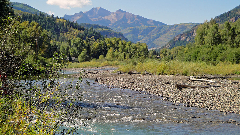
In the southwest corner of the state, the San Juan River springs to life on the Continental Divide near Wolf Creek Pass, and grows in size with runoff from rivers such as the Pine, Piedra, Animas, Mancos and La Plata on its journey to the Colorado River. The San Miguel joins the Dolores River after it turns back to the north to join the Colorado. Unlike many other parts of the state, there are individual rivers and multiple sub-basins that provide the water we rely on.

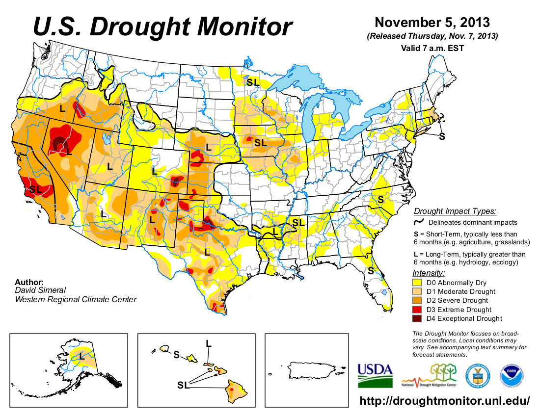
Water is also a limited resource. Studies show that in the coming decades, there could be a gap between water supply and demand of half a million acre-feet or more per year in Colorado. The entire state is threatened by this scenario, and it is particularly threatening to our rural communities. Unless something is done now to manage and plan for our water future, more and more agricultural water rights will be bought up to supply our growing cities, drying up hundreds of thousands of acres of productive farm and ranch land and jeopardizing the economy and livelihood of rural Colorado. Northeastern Colorado alone is expected to lose about 20 percent of the agricultural land currently under production from purchase agreements already in place.

This “buy and dry” process should not be the only source of water to meet our future needs. We must have a plan that provides a secure water future for all Coloradans. In May of this year, Gov. John Hickenlooper issued an executive order directing the Colorado Water Conservation Board to develop Colorado’s Water Plan. This is an unprecedented undertaking for Colorado, but fortunately, much of the work that is needed for development of the plan is already done.

During the drought of 2002-03, the state commissioned the most comprehensive study ever done of Colorado’s current and future water demands and supplies, a study which is continually being updated to include the most current information available. In addition, in 2005 the state Legislature created nine basin roundtables, groups of water leaders from each major river basin that have been evaluating their basin’s water challenges. The Legislature also created the Interbasin Compact Committee, a group of 27 leaders representing every major river basin and water constituency, including two representatives from each roundtable. For the last several years these groups have been engaged in thoughtful dialogue, working hard to understand and address Colorado’s water challenges.

The CWCB, IBCC and basin roundtables have reached consensus on a variety of actions that will lead to a sustainable water future, including support for alternatives to permanent buy-and-dry of agriculture, promoting water conservation, developing new projects that meet multiple needs, and more.

The development of Colorado’s Water Plan will not be a top-down process, nor will the plan be full of state-level mandates and directives. Instead, it will be built on the foundation of the work of the basin roundtables and the IBCC.

To create the foundation, each basin roundtable is in the process of developing a basin plan for their region. At the same time, the IBCC is developing a “no and/or low regrets” strategy for meeting future water needs that could be applied statewide. Because these efforts are currently underway, we don’t yet know all the components of Colorado’s Water Plan. What is known is that Colorado’s Water Plan will be a balanced plan that will reflect Colorado’s values. The governor’s executive order specifies that Colorado’s Water Plan must promote “a productive economy that supports vibrant and sustainable cities, viable and productive agriculture, and a robust skiing, recreation and tourism industry; efficient and effective water infrastructure promoting smart land use; and a strong environment that includes healthy watersheds, rivers and streams, and wildlife.”

Using the basin plans and the work of the IBCC, the Colorado Water Conservation Board will deliver a draft plan to the governor by Dec. 10, 2014. It will then work with the governor’s office to finalize Colorado’s Water Plan no later than December 2015.

To provide your insights and perspectives, participate in the next meeting of the Southwest Basin Roundtable at 3 p.m. Nov. 13 at Durango Public Library.

To learn more about the members of the roundtable and to find out when meetings are scheduled, visit http://www.cwcb.state.co.us and go to the IBCC and basin roundtables link. You can also submit your comments on the water plan to the CWCB by emailing cowaterplan@state.co.us.

For more information, visit Colorado’s Water Plan online at http://www.coloradowaterplan.com.

Bruce Whitehead is a member of the Southwest Basin Roundtable, Interbasin Compact Committee representative and executive director of the Southwestern Water Conservation District. Reach him at brucew@southwesternwater.org.

More Colorado Water Plan coverage here.

Snowpack news: Roaring Fork River watershed off to a good start

Book: A Thousand Year Rain,The Historic Flood of 2013 in Boulder and Larimer Counties #COflood

Air search for flood victims September 2013 via Pediment Publishing
Air search for flood victims over Jamestown September 2013 via Pediment Publishing

From Pediment Publishing:

We are proud to present this hardcover pictorial book that captures the devastation of the massive flooding that swept across Boulder and Larimer counties, and the indomitable spirit of our friends and neighbors that live here.

Five percent of all sales will be donated to the Community Foundation of Northern Colorado and the Foothills Flood Relief Fund for Boulder and Broomfield Counties.

From The Denver Post (David Olinger):

The September floods damaged 27 Colorado dams, causing an estimated $5.4 million in damages. That estimate was derived from an emergency statewide inspection of 207 dams swollen or breached by a week of record-setting rainstorms. In general, Colorado dams survived the storms in much better shape than Colorado highways. Some that need repairs will be required to lower their water levels until the work is completed.

“We felt pretty lucky, for sure,” said Bill McCormick, the state’s chief dam safety engineer. “Most of it is relatively minor. It was a lot of erosion and sinkhole development.”

State dam engineers had a lot of help on the emergency inspection project. Altogether, 113 engineers took part, including inspectors from four federal agencies and 27 engineering firms.

At the height of the storms, The Denver Post reported that flooding blew out at least six dams in a day. In the aftermath, the state Division of Water Resources reported that nine dams had been breached from Larimer County to El Paso County. But all of the state’s high-hazard dams, which would likely cause fatal flooding if they failed, withstood the storms.

McCormick said most of the dams needing repairs are owned by public entities that can qualify for assistance from the Federal Emergency Management Agency.

From The Greeley Tribune:

This is the first of periodic updates on flood recovery to be released by the Weld County Office of Emergency Management. Look for updates in the future with this logo.

Flood recovery updates

» FEMA has approved an extension for storm and flooding survivors to register for federal disaster assistance. The new registration deadline is Nov. 30, which is also the new deadline to complete and return low-interest U.S. Small Business Administration disaster loan applications. Register with FEMA by phone at 1-800-621-3362, seven days a week. Multilingual phone operators are available on the FEMA helpline.

» The deadline for Colorado residents to file an insurance claim with the National Flood Insurance Program is 60 days after flood damage to an insured structure.

» Weld County opened another road Monday. Weld County Road 15 ½ north and south is now open. Six county roads remain closed.

» Debris removal operations are well underway. About 95 percent of the debris washed up on roads has been removed. Residential pickups are about 75 percent complete. Two letters have gone out to the public notifying them of debris removal. Pickup will continue until mid-November.

» Weld County is hosting weekly meetings to coordinate recovery efforts. This is a local government coordination meeting among department heads and staff, and is organized by Recovery Support Functions. These meetings are not open to the public, but the county wants the public to know that work is still being done by county officials and community leaders. If you would like to help in recovery programs, or if you need assistance, call 2-1-1. If calling from a cell phone, call (970) 353-8808.

» Number of applicants who have received housing assistance in Weld County: 966.

» Number of jurisdictions and nonprofit organizations from Weld County that have applied for FEMA assistance: 29.

Please continue to monitor the Weld County Government Facebook page for updates, and go to http://www.weldgov.com for important flood recovery information.

Lincoln Park/Cotter Mill superfund site: 9,000 gallon spill contained on mill property

Lincoln Park/Cotter Mill site via The Denver Post

From The Pueblo Chieftain (Tracy Harmon):

Cotter Corp. Uranium Mill officials on Tuesday discovered contaminated water escaped a pump-back system at the mill site but the spill has been contained to the mill property. According to Warren Smith, community involvement manager for the state health department, the release of contaminated water was limited to between 4,000 and 9,000 gallons. The leak occurred at the junction of two pipe sections near the Soil Conservation Service pump back site, which is designed to prevent contaminated surface water from seeping into the neighboring Lincoln Park neighborhood.

“The soil in the area of the release is saturated. It will be allowed to dry so the pipe can be excavated and repaired,” Smith said.

Water samples were analyzed and based on concentration levels present, the maximum estimated release of uranium is limited to 1.1 ounces and the estimated molybdenum release is 2.6 ounces.

Contaminated water usually is pumped, along with groundwater, to an onsite evaporation pond to prevent further contamination in Lincoln Park, which has been a part of a Superfund cleanup site since 1988. The now-defunct mill is in the process of decommissioning and has not been used to process uranium since 2006.

From the Colorado Independent (Shelby Kinney-Lang):

Cotter Corporation informed the health department of the leaking pipes on Tuesday in a “verbal report” delivered over the phone. No health department personnel have inspected the spill site, as yet, and no formal report has yet been filed. Cotter said it will let the contaminated ground dry before excavating and repairing the pipe…

“We’ve got a company looking to walk away from a problem without actually cleaning it up,” said Travis E. Stills, an energy and conservation lawyer who has been working with community groups in Cañon City since the mid-2000s. Stills represents Colorado Citizens Against Toxic Waste on several ongoing state open records suits that seek information that passed between Cotter, the state health department and the Environmental Protection Agency concerning the uranium mill and the Lincoln Park Superfund Site, but which health department withheld from public review.

Uranium is extraordinarily toxic. The health department reports that if the pipe did in fact leak 9,000 gallons, the concentration in the water of uranium would be 834 micrograms per liter and the concentration of molybdenum, also a toxic chemical, would be 2,018 micrograms per liter. For perspective, the EPA places the health safety level of uranium at 30 micrograms per liter…

“They got a hole in the pipe and it leaked back into the ground,” he said.

Warren Smith, community involvement manager in the Hazardous Materials and Waste Management Division of the department, insisted there was no danger to public health.

“There is no public health risk here, because there is no exposure to the public,” Smith said. “Health risk depends on two factors: the release and exposure. If there’s no receptor to be exposed to it, where’s the risk?”

Smith said that the health department performs regular inspections of the Cotter site. The most recent was a September inspection. Because the pipe was buried, Smith said it would be a stretch to “characterize it as an [inspection] oversight.”

Smith said it would be a serious lapse if Cotter had failed to report the spill. Inspections don’t occur often enough for the state to have happened upon the spill any time soon.

More Lincoln Park/Cotter Mill superfund site coverage here and here.

Pitkin County commissioners approve purchase of properties near Redstone for open space

Crystal River near Redstone via Wikipedia Commons

From The Aspen Times (Michael McLaughlin):

On Wednesday, the Pitkin Board of County Commissioners unanimously approved the purchase of two Redstone River parcels that comprise approximately 21.3 acres and are contiguous to Elk Park and Redstone Park on the south as well as the Redstone Boulders Open Space on the northeast.

The two parcels up for purchase would tie all of these properties together into a seamless river corridor containing more than a mile of riverfront between Coal Creek and a well-used beach area upstream from the north Redstone Bridge…

One of the properties includes the confluence of Coal Creek with the Crystal River. The current confluence isn’t the natural area where the two waters meet but one that was put in when the state was working on Highway 133 in that area. In its natural state, Coal Creek used to run through wetlands before it met with the Crystal River downstream from the present confluence area. Coal Creek experiences frequent debris flows that feed coarse rock and wood into the creek, which in turn collect at the confluence of Coal Creek and the Crystal River. This causes pooling of water and erosion by both streams. It also causes a sediment buildup that raises the riverbed of the Crystal near Redstone, elevating flood danger…

A public hearing concerning the purchase will be held at the commissioners meeting on Nov. 20. Will said the public can rest assured that questions of access will be driven by habitat management.

More Crystal River Watershed coverage here and here.