
Day: November 27, 2013
Ed Quillen: Water principles of the West begin with blaming California

Coyote Gulch reader Greg sent this link to an Ed Quillen column from the High Country News from April 28, 2003. Greg writes, “Ten years past and its more valid today, than the day Ed wrote it.” Here’s an excerpt:
The new water principles, codified earlier this year after lengthy discussion, contain all the proper modern buzzwords, like “consensus” and “respect.” Who could find fault with “the implementation of consensus-based water resource solutions that respect local authorities”? Or with “maintaining the proper stewardship of the land”? Or with “earnest efforts to find water supply answers that benefit all Coloradans, for this and future generations”?
In other words, these principles are about as controversial as safe streets and neighborhood schools. But there is a problem, and that is that they ignore the traditional principles that have, for the last century or so, pretty well defined water policy in the West.
Thus it only seems proper, if we’re going to adopt some New Water Principles, to remember our Traditional Western Water Principles:
Whenever there’s a water problem, it is always the fault of California. When mountain streams are flooding, it’s because California won’t let new dams be built in the Rockies. When the mountain reservoirs are shrinking, it’s because California keeps taking water it is supposed to get under the 1922 Colorado River Compact. California is a safe party to blame, because it’s so big and rich that nobody there needs to care what we say about it. Besides, it’s a Democratic domain, and our Republican officials need to blame somebody.
In all water development, the federal government should cover most of the cost, and preferably the entire tab. After all, the Winning of the West has been a national priority since about 1777, and there’s no reason to stop now.
No water project is ever built to assist developers and subdividers. Even if they’re the ones who will benefit the most, the official purpose will be to benefit hardscrabble farmers, struggling ranchers or Native Americans.
If there’s not enough water to serve new developments, then current users should make sacrifices. In other words, the more water you conserve, the more water that will be available for big-box stores, shopping malls and sprawling suburbs. These developments generally increase your cost of living and reduce your quality of life, but you will be told that “we’re all in this together” and you’ll be seen as rather churlish and mean-spirited if you object to killing your last tree so that Vista Heights Gated Golf Course Community can continue selling lots.
Any solutions to water-supply problems should feature new structures (dams and reservoirs are best, but canals and tunnels are acceptable) which can be named after their political sponsors — i.e., Hoover Dam in Nevada, Alva Adams Tunnel in Colorado, Theodore Roosevelt Dam in Arizona. Water projects need political support, and it’s easier to get it with the imposing Sen. Josiah R. Claghorn Dam and Reservoir than with the Claghorn-Smith Instream Flow Protection Act of 2003. Construction can confer a degree of immortality on a public servant. It also shows the constituents that they’re getting their fair share from the pork barrel, and that’s important, especially in election years.
These are the principal principles that have guided Western water development over the years, and it seems odd that they were not addressed by the people who came up with the new and improved water principles.
But on the other hand, that could be because no one has ever figured out how to repeal the supreme law of our hydrology, first articulated by John A. Love, a Republican who served as governor of Colorado from 1963 to 1973: “Water flows uphill to money.”
We’re at it again: More Colorado Water Plan coverage here. And so it goes.
Denver: AGWT is hosting a Colorado aquifer management event on Tuesday

From The Greeley Tribune:
The American Ground Water Trust, based in New Hampshire, is hosting a Colorado aquifer management event on Tuesday in Denver.
The event is a follow-up conference to the two-day program held in Denver in November 2012, where legislators, groundwater experts and water managers discussed stream depletions due to well pumping, and other groundwater issues.
Presenters include Reagan Waskom, director of the Colorado Water Institute at Colorado State University; James Eklund, director of the Colorado Water Conservation Board; Reed Maxwell, director of the Integrated Groundwater Modeling Center at the Colorado School of Mines; Kevin Rein, deputy state engineer at the Division of Water Resources; Don Shawcroft, president of Colorado Farm Bureau; Andrew Stone, executive director of American Ground Water Trust; Sen. Scott Renfroe, R-Eaton; Rep. Randy Fischer, D-Fort Collins; and Rep. Dave Young, D-Greeley.
To register for the event or learn more, go to http://www.agwt.org/events.
More HB12-1278 coverage here. More groundwater coverage here.
The State Legislature Disaster Study Committee gets a first hand look at ongoing problems with recovery #COflood

From The Greeley Tribune (Dave Young):
On Nov. 18 and 19, the state legislature’s Flood Disaster Study Committee visited Longmont, Lyons, Estes Park, Glen Haven, Milliken and Evans, and held public hearings in Longmont, Estes Park and Evans. The fully bipartisan 12-member committee, which I chair with Sen. Scott Renfroe, is gathering information to decide what the Legislature should do to improve the state’s response to the 2013 flood disaster and to better prepare for the floods that, inevitably, will strike our state again.
I and the other representatives and senators on the committee all come from places that experienced some degree of flood damage, and naturally we’ve been focusing mostly on our own constituents. This field trip gave us a broader perspective and reminded us that the flood recovery, like all the other big challenges facing our state, is best confronted if we act together.
In every town, people told us that Gov. John Hickenlooper and his administration have done a fantastic job of responding to the disaster. The last stretch of highway wrecked by the floods reopened Tuesday. My hat’s off to the governor and to the thousands of state, county and local workers and contractors who made the impossible happen. And other state agencies have been on the ball helping flood victims take care of the basic necessities and navigate the red tape of insurance claims and applications for assistance.
But make no mistake: difficult problems remain if we are to avoid what everyone’s calling “the disaster after the disaster.” For example:
» Businesses. Businesses need employees and customers, and both can be hard to find in an area with a lot of displaced residents.
» Irrigation ditches. The floods breached ditches and canals throughout the flood zone. Those ditches fill our reservoirs and water our farmers’ fields. If the ditches aren’t repaired soon, agriculture will suffer badly and entire communities may get thirsty.
» Water and soil contamination. Leaks from oil and gas storage tanks are a concern, especially here in Weld County. Sewage contamination of soil and water is another problem.
» Other infrastructure. Roads and bridges weren’t the only structures damaged by the flood. Other infrastructure — notably wastewater treatment plants — need repairs.
There are other pitfalls to avoid. But I think we’ll come out of this better and stronger than before if we pull together and continue to show the bend-not-break Colorado spirit we’ve seen so far.
For example: Glen Haven, in the mountains west of Loveland, was nearly wiped out. You could understand if folks there had said, “This was great while it lasted,” and then found somewhere else to live. But when the committee rolled into town, one of the first people we saw was Tony Fink. I knew Tony from his days as a doctor in Greeley. Now he’s retired and living in Glen Haven, and we saw him scooting around town on his ATV, coordinating, helping people, making sure they were OK. Tony is basically the emergency manager of Glen Haven now. There is no quit in Tony Fink. And there are people like him in every community we visited. I will not let these people down.
State Rep. Dave Young represents House District 50, which includes central Greeley, Evans and Garden City.
From The Greeley Tribune:
Nearly $12 million is being released to help restore watersheds damaged by September floods.
The $11.7 million from the Natural Resources Conservation Service’s Emergency Watershed Protection program will help cover 75 percent of the costs for 26 emergency projects, such as the stabilization of riverbanks and rechanneling of rivers and streams that were redirected following the historic floods that swept through Colorado’s Front Range.
The release of funds was welcomed by Colorado U.S. Senators Michael Bennet and Mark Udall. Bennet and Udall led the Colorado Congressional delegation in requesting the NRCS — along with the Federal Emergency Management Agency and the U.S. Army Corps of Engineers — to prioritize these projects.
Snowpack news: Weekend storm exceeds forecast in the Upper Arkansas Valley #COwx
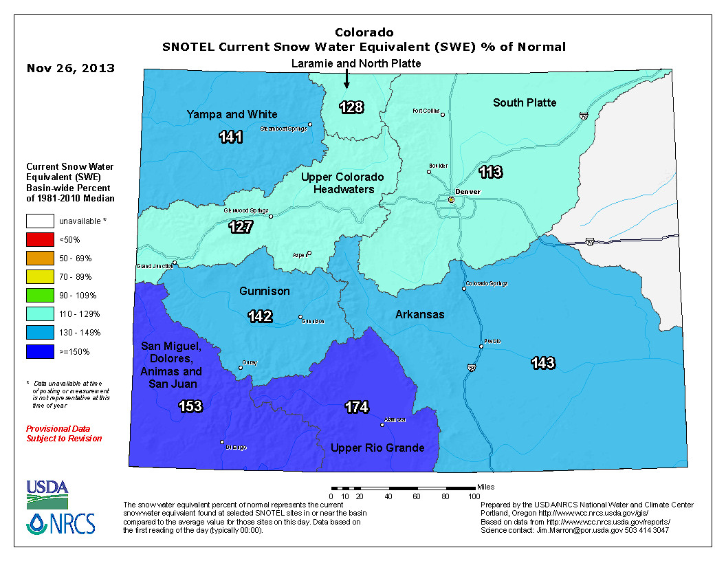
From The Mountain Mail (Brian McCabe):
Salida received more than the 3-5 inches of snow forecast for Thursday through Sunday, with reports of 12-16 inches of snow around town. All of the snow equaled .78 inch of precipitation, bringing the November total to .96 inch, .41 inch more than the average of .55 for the month.
Salida’s year-to-date precipitation totals 11.52 inches, 1.23 inches more than the historical average of 10.29 inches for January through November.
“This was really just a drop in the bucket in the big picture,” said Bill Gardiner of the Colorado Natural Resources Conservation Service. “It would take quite a few years of above average moisture to get us up to where we should be, but this is a good start.”
US Senators Bennet and Udall are urging Congress to appropriate more funding for flood relief efforts #COflood

From the Northern Colorado Business Report (Steve Lynn):
U.S. Sens. Mark Udall and Michael Bennet are urging the Senate Committee on Appropriations to provide Emergency Watershed Protection funding following September flooding.
Officials in counties in Northern Colorado, including Weld and Larimer counties, have identified an estimated $216 million in watershed projects related to the flooding. Bennet and Udall asked committee members in a letter to direct additional funding to the Emergency Watershed Protection program, which has less than $25 million available nationally.
The funding is needed for tasks such as stabilizing river banks and rechanneling waterways, the senators wrote.
Kevin Duggan: Larimer County estimates its flood-repair costs will be about $108M #COflood
Larimer County estimates its flood-repair costs will be about $108M; after reimbursements, the county's share is expected to be $17M
— Kevin Duggan (@coloradoan_dugg) November 25, 2013
‘Farm Bill watchers are once again wondering how and if Congress can finish this bill’ — Patty Lovera
From Food and Water Watch (Patty Lovera):
In what seems to be a new rite of fall, Farm Bill watchers are once again wondering how and if Congress can finish this bill before the end of the year. At the end of last week, talks between the leadership of the House and Senate Agriculture committees broke down, which means finishing the Farm Bill using the normal process in 2013 would be nothing short of a winter holiday miracle.
To recap: The 2008 Farm Bill expired on October 1, 2012. Then on New Year’s Day, a 9-month farm bill extension was included in the bill that was passed to fix the supposed “fiscal cliff.” But the extension didn’t cover everything that was in the 2008 bill, and left dozens of programs for sustainable and organic agriculture, beginning farmers and disaster assistance behind. And on October 1 of this year, that short-term extension expired too.
So once again, we are finishing the year with an expired Farm Bill, waiting to see if Congress can finish the process and pass a new bill before “permanent law” (from the 1930’s and 1940’s) kicks in and affects the price of farm commodities like milk.
With Congress in session for just a handful of days this year, they have a lot to do. The bill is currently in conference committee, which has to reconcile the very different versions passed by the House and Senate. The major sticking points are the commodity programs and nutrition programs…
One of the biggest points of debate seems to be how to calculate the payments to farmers in a way that complies with the World Trade Organization rules about farm subsidies. Missing from this process is any discussion of the real reforms we need, including restoring grain reserve programs that could be used to provide stability for farmers and rein in overproduction of these commodity crops.
On nutrition, the gap between the House and Senate is huge. The Senate bill would cut $4 billion from SNAP (the Supplemental Nutrition Assistance Program, formerly known as food stamps), while the House bill would cut almost $40 billion. This is a huge sticking point and Senate Democrats have vowed not to accept a cut that large and the President has threatened to veto any bill with such a cut.
‘As the population of Colorado grows, so will the tension on water supplies and water quality’ — Kate Burchenal

Here’s a guest column about the Colorado River Watch program, written by Kate Burchenal that is running in the Vail Daily:
Did you know that Colorado is home to more than 700,000 miles of rivers, streams and creeks? Think about that: 700,000 miles. Considering that the Earth’s circumference is approximately 25,000 miles, end to end; Colorado’s waterways could circle the globe 28 times. And if we want to take this comparison to outer space, then one could travel to the moon and back and still have more than 200,000 miles to spare! Ready for more staggering numbers? Colorado’s population recently surpassed the 5 million mark, 5.18 million actually, which equates to 7.4 people per river mile.
Here in Eagle County, we love the waterways that meander through our towns and lives. Eagle County houses the entire 77 miles of the Eagle River from the headwaters on Tennessee Pass to its confluence with the Upper Colorado in Dotsero. We also play host to 55 miles of the Colorado River as it skirts through the northwestern part of the county. Fifty-five miles amounts to a mere 3.8 percent of the total length of the river, but we are nevertheless glad to have that access and proximity to the mighty Colorado.
As the population of Colorado grows, so will the tension on water supplies and water quality due to potential for increased pollution. But there’s passion among our population. People are moving to Colorado in droves to gain access to our skiing, rafting, hiking, fly-fishing and clean-air-breathing! And most of us care deeply about our watersheds and show that dedication if given the chance. So, why not put that passion to work monitoring water quality on our rivers?
Colorado River Watch
Since 1989, Colorado River Watch has provided such an opportunity by “work(ing) with voluntary stewards to monitor water quality and other indicators of watershed health and utiliz(ing) this high-quality data to educate citizens and inform decision makers about the condition of Colorado’s waters.” It coordinates water sampling by volunteer groups from around the state: middle and high school classes, local governments, environmental organizations and concerned individuals.
During the years, River Watch has collected data from more than 3,000 sites around Colorado on more than 300 of our local waterways. Each month, volunteers collect water samples from their stations to test for six main parameters: heavy metals, dissolved oxygen, pH, alkalinity, nutrient levels and hardness. Twice a year, volunteers add the collection of macroinvertebrate samples to understand the health and composition of the bug population.
Every sample is processed and carefully chronicled by River Watch in its Fort Collins lab. This information is then used by the Water Quality Control Commission (the administrative agency responsible for developing state water quality policies) to set statewide standards for allowable levels of constituents in the water, particularly metals. That’s right, River Watch training and quality control standards are so stringent that information collected by average residents is utilized to set state standards!
Here in the Eagle Valley, we have more than 12 stations in the hands of numerous River Watch partners: The Eagle River Watershed Council, the town of Vail, individuals and local classrooms. We want to get even more people out on the water taking part in this exciting program whether it is a class, a community group, an afterschool activity program or a family. It’s a great learning tool and a wonderful way for everyday people to have a hand in state water quality issues.
Kate Burchenal is the education and outreach coordinator for the Eagle River Watershed Council. The Eagle River Watershed Council has a mission to advocate for the health and conservation of the Upper Colorado and Eagle River basins through research, education and projects. Contact the Watershed Council at 970-827-5406 or visit http://www.erwc.org.
Shoshone
More Shoshone plant coverage here.