Jon Monson retires from @GreeleyWater

Greeley Irrigation Ditch No. 3 construction via Greeley Water

From The Greeley Tribune (Analisa Romano):

When Jon Monson was hired by the city of Greeley to act as director of the Water and Sewer Department 18 years ago, he was all arms in the air and enthusiasm for the job.

“You’re on the side of angels,” Monson told The Tribune in an April 29, 1996, interview — just 10 days into the job. “You’re one of the good guys protecting the environment … and providing water that’s necessary for life. That’s exciting.”

On Thursday — just three days into retirement — not much had changed.

“I would like to stay involved in water,” Monson said of his plans as a retiree. “People respect the transformative power of water to create the environment we want to create.”

Monson’s passion for the job came up a number of times among coworkers and friends at Monson’s last day this week as something they will remember him by and miss.

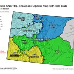
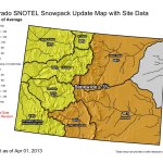
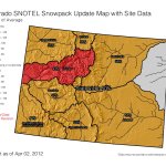
Monson will be missed for his quotes from famous people like Benjamin Franklin and Plato, his “data-dense” graphics, his Socratic style and his Christmas bread, said Harold Evans, chairman of the Greeley Water Board, at Monson’s retirement party Monday.

But more importantly, Monson will be missed for his leadership.

“Things work well and are delivered in a cost-effective manner, plus Greeley is positioned well for the future with its critical infrastructure of water and wastewater,” Evans said. “That’s the definition of leadership.”

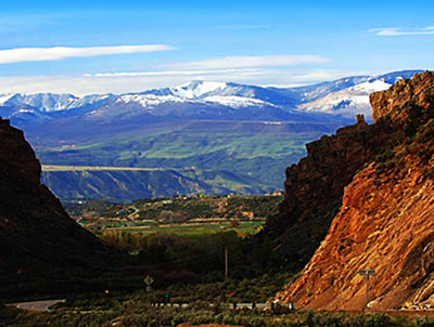
In his time with the city, Monson set the tone for the development of Greeley’s water system with the 2003 Water Master Plan, helped rebuild both the Bellvue and Boyd Lake water treatment plants, was recognized by the state for the city’s water conservation program, expanded the Bellvue pipeline to near completion, acquired at least 10,000 more acre-feet of water in anticipation of population growth, oversaw a great deal of improvements on the sewer system and created more local water storage, such as at the Poudre Ponds.

Through it all, Monson has never faltered in saying he loves his job, said Charlotte Hansen, his wife.

“To be able to love your work, that is a true gift in life. Well, this man loves his work. Believe me,” Hansen said at Monson’s retirement party.

There were challenges through the years, the worst of which was the painstakingly long process of environmental permitting for projects like the Bellvue pipeline or water storage, Monson said. Although even those things he said he understood as necessary components of the job.

Greeley Mayor Tom Norton said Monson steered the city particularly well through major upgrades to Greeley’s wastewater treatment plant, which has been recognized by the EPA for sustainability and energy efficiency.

“Jon led the way to making the wastewater facilities as important as water facilities, and our stewardship for clean water downriver as well as clean water upriver,” Norton said. “I think that’s very, very important.”

Monson also was honored this week by the Farr family, who said W.D. Farr — a Greeley leader who left a number of legacies, including planning for water — was particularly fond of him.

“It was such a wonderful gift that W.D. gave me in the last decade of his life, to give some inkling, some fraction of what he knew about water,” Monson said Thursday. “The more I think about it, it was a gift from me to him to give him the opportunity to share what he knew. And I hope to do that, to find some way of passing that on.”

During retirement, Monson said he hopes to work for Engineers Without Borders and work on his fly-fishing skills. In the near future, Monson will be sailing, traveling to Europe to visit his wife’s family and track down his own ancestors and meet his daughter in Nepal as she and her husband motorcycle through South Asia.

Before Greeley, Monson worked in south Florida as a utility director. Before that, he lived in Boulder and moved around the South as a water engineer.

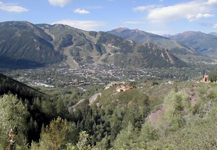
“Greeley has been really good to me,” Monson said Thursday with a nostalgic smile. “It was a good place to spend half my career.”

More Greeley coverage here.

“There is no additional water for additional support to other basins” — Steve Acquafresca #COWaterPlan #ColoradoRiver

Colorado transmountain diversions via the State Engineer's office
Colorado transmountain diversions via the State Engineer’s office

New transmountain diversions of water from the Colorado River Basin to the Front Range got a frosty reception from Grand Valley water users and residents Thursday.

At certain times during the year, more water travels east through tunnels than flows downhill along the Western Slope, said Max Schmidt, general manager of the Orchard Mesa Irrigation District, during a town hall meeting in Grand Junction City Hall on the development of a statewide water plan.

“There’s nothing left to give,” Schmidt said to about 40 people gathered in the meeting sponsored by the Colorado River Basin roundtable and the Water Center at Colorado Mesa University.

Grand Valley water users haven’t strayed from their original reaction to calls for a new transmountain diversion, said Larry Clever, general manager of the Ute Water Conservancy District, the largest supplier of water in the Grand Valley.

“It’s going to be a fight” if a new transmountain diversion is proposed, Clever said. “If Lake Mead and Lake Powell spill over, then maybe, but until then, we fight.”

State officials have said the statewide water plan, which is to be complete by December 2015, with a draft due to Gov. John Hickenlooper by this December, won’t include a transmountain diversion. The plan, however, is expected to outline the terms under which one might go forward.

Comments in the town hall are to be reflected in a Colorado River Basin plan. It, along with other basin plans, are to be reflected in the statewide plan.

The Colorado River Basin is already a donor basin unable to meet the demands that officials expect by 2050, Mesa County Commissioner Steve Acquafresca said.

“There is no additional water for additional support to other basins,” Acquafresca said.

More Colorado Water Plan coverage here.

The City of Aspen has a long list of projects for the #ColoradoRiver Basin Implementation Plan #COWaterPlan

aspen
From Aspen Journalism (Brent Gardner-Smith):

Tall new dams in pristine spots on upper Castle and Maroon creeks. Bigger dams on Lost Man and Lincoln creeks in the headwaters of the Roaring Fork River. A bigger reservoir at the city’s water plant. Water pumped up from deep underneath Aspen. Treated effluent pumped from the Aspen wastewater plant to the city golf course. Water left in the river instead of being diverted to the Wheeler irrigation ditch.

These projects are all on a list that Mike McDill, the city of Aspen’s deputy director of utilities, wants included on a larger list of regional water projects now being compiled by the Colorado River Basin Roundtable.

“If it is already on the list, at least people can’t say they didn’t know we were thinking about it,” McDill said…

Over 500 “projects, policies and processes” are now on the Colorado roundtable’s draft priority list, including Aspen’s suggested projects. The list, which is part inventory, part to-do list, and part wish list, is to be winnowed down in the next two months by the roundtable.

“Putting projects on the roundtable’s list is a good way to provoke conversation,” said Louis Meyer, a consulting engineer with SGM, who is leading the development of the Colorado roundtable’s basin plan. “It is also incumbent on us to show the state that we have a list of water needs.”[…]

During recent public roundtable meetings, McDill has described Aspen’s list of projects in a calm and pragmatic matter, despite the scale of some of them.

“Our concern is we have a lot of water in June and not so much water the rest of the year,” McDill said about the potential value of reservoirs on upper Maroon and Castle creeks.

Today the city of Aspen diverts water from lower Castle and Maroon creeks for its water supply, but it does not have any water storage capacity beyond the tiny Leonard Thomas Reservoir at the water plant, which can hold 14 acre-feet of water.

If built someday as described by the city’s conditional water right, the Maroon Creek reservoir would store 4,567 acre-feet of water behind a 155-foot-tall dam just below the confluence of East Maroon and West Maroon creeks, which is known as a stunningly beautiful location. A Maroon Creek reservoir would cover 85 acres of U.S. Forest Service land about a mile-and-a-half below Maroon Lake.

The Castle Creek reservoir would hold 9,062 acre-feet of water behind a 170-foot-tall dam located about two miles below the historic town site of Ashcroft in a verdant valley. It would inundate 120 acres of mostly private land.

The city has renewed the conditional water rights for the two reservoirs eight times since they were decreed in 1971 and is required to do so again in 2016, when it must show it is making progress toward building the reservoirs.

“Aspen will build the Castle Creek and Maroon Creek reservoirs if necessary and if in the best interest of citizens of the community,” city officials said in 2012…

Also on Aspen’s list of potential projects is the enlargement of existing reservoirs, including Grizzly Reservoir and Leonard Thomas Reservoir…

Grizzly Reservoir was built in the 1930s on upper Lincoln Creek, a tributary of the Roaring Fork River. The reservoir is owned by the Twin Lakes Reservoir and Canal Co., of which the city of Colorado Springs is now the majority owner. The reservoir holds about 570 acre-feet of water and primarily serves as the forebay to the tunnel that Twin Lakes uses to divert water under the Continental Divide…

The smaller Lost Man Reservoir, also owned by Twin Lakes, backs up water on Lost Man Creek and then diverts it to Grizzly Reservoir…

But Kevin Lusk, a principal with Colorado Springs Utilities, and the president of the Twin Lakes Reservoir and Canal Co., threw cold water this week on the idea of expanding either Grizzly or Lost Man reservoir.

“Twin Lakes has no plans or interest in enlarging these facilities,” Lusk said via email. “Nor has anyone talked to us about these ideas.”[…]

Also on the city’s list is expanding Leonard Thomas Reservoir at the city’s water plant above Aspen Valley Hospital so it can hold 25 acre-feet instead of 14 acre-feet…

Another water project on the municipal list is to determine just how much water is under the city of Aspen, and whether it is suitable for drinking.

In 2012 and 2013, the city drilled a water-well near Herron Park 1,520 feet underground in search of hot water it could use for geothermal energy.

But in July 2013 the city announced that it did not find water hot enough to make electricity, but it did find a steady stream of clear water coming up out of the well at 29 pounds per square inch, about half of the water pressure in a normal household.

“This summer, we’re putting a pump into the well to analyze the water and get some feel for the capacity of the aquifer,” McDill said.

If it turns out there is still a lot of water 1,500 feet underground Aspen, the city may install a larger, permanent pump into its test well to create a back-up supply of water…

The pump back project, which is well under way, will allow the city to reuse water from the Aspen Consolidated Sanitation District to supplement its irrigation water on the municipal golf course, and to provide irrigation and snowmaking water for other entities, including the Buttermilk Mountain ski area.

“It is intended to keep more water in the Castle Creek by not diverting for the golf course,” McDill said.

The source of the water is “treated municipal effluent” and pipes already have been installed from the sanitation plant, past the Burlingame neighborhood, and to a pond on the city golf course.

The city is still seeking a water right for its pump back project from state water court, and has been working out agreements with a long list of opponents.

The water is to be primarily used to irrigate 12.3 acres of landscaping along Highway 82 and Cemetery Lane, according to documents in water court. It also could supplement irrigation on 131 acres of the Aspen golf course, 21 acres of land in the Burlingame project, and 80 acres of the Maroon Creek golf course.

In all, 233 acres of land could receive water from the project and water could be used to make snow on as much as 156 acres of land at Buttermilk…

The Fork is often below a flow level of 32 cfs, which is the minimum amount of water the CWCB has determined is necessary to protect the environment “to a reasonable degree.” Last year, the city entered into a short-term water [lease] with the CWCB to leave 6 cfs of water in the river instead of diverting the water into the Wheeler Ditch, which is located river-left just downstream of the Aspen Club pedestrian bridge. The water in the Wheeler Ditch is typically used by the city for landscaping and irrigation in various parts of central Aspen…

The Colorado River basin roundtable is scheduled to next discuss its draft list of projects on Monday, April 14, from noon to 4 p.m. at the Glenwood Springs community center.

More Colorado Water Plan coverage here.

Snowpack/runoff news: Roaring Fork watershed early April accumulations looking good #COdrought #COflood


From the Glenwood Springs Post Independent (Will Grandbois):

he state as a whole is roughly 115 percent of normal, with a sub-par winter in the southern mountains (including the Rio Grande, Dolores and San Juan drainages) bringing the average down somewhat. Snow telemetry (SNOTEL) data provided by the Roaring Fork Conservancy shows a snow-water equivalent of 126 percent of normal in the Upper Colorado River Basin.

That’s the equivalent of about 20 inches of liquid water across the valley’s high country, well above peak snowpack in both 2012 and 2013, as well as the 30-year average for the region. It has been a good year for skiers, and it looks promising for healthy rivers and forests into the summer.

April is a key month in forecasting the year’s stream flow. Often it represents the peak snowpack for the Water Year, which runs October through September. This trend has been subverted in recent years. Early melting in 2012 signaled the beginning of one of the worst fire years in memory, while late runoff in 2013 was a small salvation in an otherwise below average year…

Dust storms, a frequent occurrence in recent years, also speed melting. The Colorado Dust-On-Snow Program recorded five such storms in the Rockies so far this year. That’s slightly less than 2012 and 2013, with a clean fall and an average March. April and May are big months for dust storms, so it’s too early to be sure how this year will compare on that metric.

“We’re now entering the thick of it,” Chris Landry, executive director of the Center for Snow and Avalanche Studies in Silverton, told the Aspen Times. He called the most recent dust storm on April 1 “a significant event,” but added that subsequent weather will dictate how this dust will play out.

So far, stream flows throughout the region are mostly above average. Discharge at Ruedi Reservoir has been set to 210 cubic feet per second, well over the 45-year average of 137 cfs. That might increase if snowpack continues to accumulate in coming weeks.

Meanwhile, many eyes are on the snowpack and the potential runoff problems in the flood affected areas along the Front Range. Here’s an report from Ryan Maye Handy writing for the Fort Collins Coloradoan. Here’s an excerpt:

Since September 2013 flooding swept across the Front Range, communities from Colorado Springs to Glen Haven have been preparing for the spring runoff, which could dislodge leftover flood debris and further damage areas torn apart by fall floodwaters. In a year with above-average snowpack, everyone from federal government conservationists to mountain fire departments are bracing for the worst.

But hydrologists and climatologists say there is no guarantee this year’s spring runoff will be as catastrophic as many anticipate. As with wildfire season, the intensity of spring runoff depends entirely on weather.

“Not all runoff seasons are created equal,” said Nolan Doesken, the state’s climatologist. “Just because you have a certain amount of snow, doesn’t mean you have a certain flooding potential. It all comes down to how snow melts.”[…]

Colorado hasn’t had this good of a snowpack — roughly 130 percent of normal — since 2011. Northern Colorado soils are still saturated after the fall floods; reservoirs are filled higher than normal, and rivers are running at twice or three times their average volume for early April.

River communities like Drake, Glen Haven, and parts of Estes Park are still scrambling to remove flood debris from the Big Thompson River’s path.

Since the September floods, places like Big Thompson Canyon have been in a race against time, trying to beat the arrival of spring runoff. The Colorado Department of Transportation hastily rebuilt the ravaged U.S. Highway 34, and has since been readying the canyon for snowmelt. Since January, the Natural Resources Conservation Service has poured all of its local energy into clearing debris or shoring up more than 44 weak points — or “exigent sites” — along the river…

Treste Huse, a hydrologist with the National Weather Service, worries that runoff will move sediment left behind by the September floods, or possibly cause land and rock slides along highways. River channels changed after the floods, and Northern Colorado residents could see water and dirt being poured into new places this spring.

But for Huse, like Doesken, this spring’s runoff potential depends on a few relatively unpredictable factors.

“It’s going to be dependent on future snowfall, how high stream levels are during the snowmelt, freezing and thawing in the mountains, future rainfall and the timing, and whether the rain falls on the snowpack,” she said.

The long and variable list of factors recently convinced Doesken that runoff might not be the catastrophe that everyone expects it to be. The state climatologist has changed his mind about this year’s snowmelt a few times–at first it wasn’t a big deal, then it was, and now the current weather pattern has him thinking Colorado could escape relatively unscathed.

If Colorado has a consistently warm spring, then the snowpack will slowly melt over time, as it did in 2011. Come summer, there will be little left once the temperatures rapidly rise, Doesken said.

On the other hand, a colder spring with a few lower-elevation snowstorms could create the opposite effect. Then, the snowpack would stay intact — even increase — until warmer temperatures suddenly hit, melting the snow rapidly. If Colorado gets a multi-day upslope winter storm that dumps moisture on the foothills, then Doesken says he will start to worry.

“The longer you push the snowmelt to when it (summer) starts, the closer to midsummer you are, it’s going to be really interesting,” he said. “It will all unfold day by day, week by week, over the course of the next six to seven weeks.”

NOAA: Heat-trapping gas concentrations top 400 ppm, two months earlier than last year

coalfiredpowerplant

From NOAA:

Over the last five days beginning on March 16, 2014, carbon dioxide levels have surpassed 400 parts per million at NOAA’s Mauna Loa Observatory in Hawaii. This is nearly two months earlier than last year when the concentration of this greenhouse gas was first recorded above 400 parts per million on May 9, at the historic NOAA observatory.

We caught up with James Butler, Ph.D., Director of NOAA’s Global Monitoring Division, to ask about what it means that we reached this milestone earlier than last year. To track carbon dioxide concentrations daily click here.

What does it mean that carbon dioxide levels topped 400 ppm on March 16 this year at Mauna Loa Observatory, nearly two months earlier than last year?

JB: 400 ppm is essentially a milestone along the way, reminding us that carbon dioxide continues to increase in the atmosphere, and at faster rates virtually every decade. This is consistent with rising fossil fuel emissions.

Why is it earlier this year?

JB: Seasonal swings in atmospheric carbon dioxide with highs in the Spring and lows in the Fall make “400 ppm” an annual event that must come earlier every year with rising atmospheric carbon dioxide.

Is there a tipping point, or carbon dioxide concentration that sets off severe consequences for human and planetary health?

JB: 400 ppm is not a tipping point. It is a milestone, marking the fact that humans have caused carbon dioxide concentrations to rise 120 ppm since pre-industrial times, with over 90 percent of that in the past century alone. We don’t know where the tipping points are.

How long do you expect these higher levels to last?

JB: Two to three months; the peak should occur again in May and this year may be over 402 ppm. Next year we expect it will be over 404 ppm, etc.

Are we seeing the increase accelerate with time?

JB: Carbon dioxide concentrations have increased every year since Dave Keeling of the Scripps Institution of Oceanography started making measurements on the slopes of Mauna Loa volcano in 1958. The rate of increase has accelerated from about 0.7 ppm per year in the late 1950s to 2.1 ppm per year during the last decade.

Please explain the role of the natural cycle for carbon dioxide emissions?

JB: Plant growth drives the uptake of carbon dioxide from the atmosphere and is strongest in the early to mid-summer. Planetary respiration from decaying plant matter puts carbon dioxide back into the atmosphere all year long, but the fall and winter drop in photosynthesis allows respiration to dominate during those months, which brings carbon dioxide back up.

Do you expect carbon dioxide levels to top 400 ppm even earlier next year?

JB: Yes. Every year going forward for a long time.

What are we seeing globally at other measuring sites?

JB: Arctic sites all reached 400 ppm about a year before Mauna Loa last year. Southern hemispheric sites will follow with South Pole reaching 400 ppm in a few years.

What would it take to reverse the upward trend of carbon dioxide concentration?

JB: Elimination of about 80 percent of fossil fuel emissions would essentially stop the rise in carbon dioxide in the atmosphere, but it would not start decreasing until even further reductions are made.and then it would only do so slowly.

La Junta: Arkansas River Basin Water Forum, April 23-24 #COWaterPlan

Arkansas River Basin via The Encyclopedia of Earth

From The Pueblo Chieftain (Chris Woodka):

A proposed state water plan, drought impacts, irrigation rules and weed control will be discussed at a regional forum in La Junta this month. The Arkansas River Basin Water Forum is planned April 23-24 at Otero Junior College. There also will be a community workshop from 6 to 9 p.m. April 22.

This is the forum’s 20th year of bringing people from all parts of the Arkansas River basin together to discuss

On the morning of April 23, James Eklund, director of the Colorado Water Conservation Board, will discuss the state’s water plan now being developed under an executive order by Gov. John Hickenlooper.

That afternoon, participants in the forum will have the opportunity to give their input into the basin’s portion of the plan.

The Bob Appel Friend of the Arkansas award will be presented at the luncheon.

On April 24, irrigation rules and the importance of agriculture to the Arkansas River basin will be in the spotlight.

Conservation and heritage will be discussed at the luncheon, with invasive species the topic for the afternoon.

For information, visit http://arbwf.org or call the CSU Extension Office, 545-2045, or Jean Van Pelt, Southeastern Colorado Water Conservancy District, 948-2400.

More Arkansas River Basin coverage here.

Rifle: Design changes help cut construction estimates for new water treatment plant

riflegap
From the Glenwood Springs Post Independent (Mike McKibbin):

The cost of Rifle’s new water treatment plant has been cut by $3 million, after some recent design changes. The city expects to put the project — funded by a $25 million loan — out to bid in early April and award a contract in June…

The new plant will be located on city property along U.S. Highway 6. Work is expected to last up to two years…

In a follow up interview on [March 21], Miller explained that the cost savings come in part from changing the design from concrete-lined sludge drying beds and gravity thickeners to clay-lined drying beds. That will save $2 million, he noted.

“Clay is cheaper than concrete and we can have city crews do that work instead of the contractor,” Miller said.

More than $1 million will be saved by renegotiating a contract with General Electric to defer a second stage membrane filtering system, he added…

More Rifle coverage here.