
From Aspen Journalism (Brent Gardner-Smith):
Tall new dams in pristine spots on upper Castle and Maroon creeks. Bigger dams on Lost Man and Lincoln creeks in the headwaters of the Roaring Fork River. A bigger reservoir at the city’s water plant. Water pumped up from deep underneath Aspen. Treated effluent pumped from the Aspen wastewater plant to the city golf course. Water left in the river instead of being diverted to the Wheeler irrigation ditch.
These projects are all on a list that Mike McDill, the city of Aspen’s deputy director of utilities, wants included on a larger list of regional water projects now being compiled by the Colorado River Basin Roundtable.
“If it is already on the list, at least people can’t say they didn’t know we were thinking about it,” McDill said…
Over 500 “projects, policies and processes” are now on the Colorado roundtable’s draft priority list, including Aspen’s suggested projects. The list, which is part inventory, part to-do list, and part wish list, is to be winnowed down in the next two months by the roundtable.
“Putting projects on the roundtable’s list is a good way to provoke conversation,” said Louis Meyer, a consulting engineer with SGM, who is leading the development of the Colorado roundtable’s basin plan. “It is also incumbent on us to show the state that we have a list of water needs.”[…]
During recent public roundtable meetings, McDill has described Aspen’s list of projects in a calm and pragmatic matter, despite the scale of some of them.
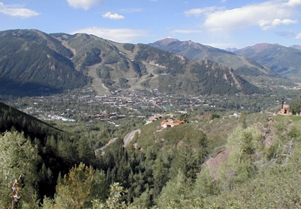
“Our concern is we have a lot of water in June and not so much water the rest of the year,” McDill said about the potential value of reservoirs on upper Maroon and Castle creeks.
Today the city of Aspen diverts water from lower Castle and Maroon creeks for its water supply, but it does not have any water storage capacity beyond the tiny Leonard Thomas Reservoir at the water plant, which can hold 14 acre-feet of water.
If built someday as described by the city’s conditional water right, the Maroon Creek reservoir would store 4,567 acre-feet of water behind a 155-foot-tall dam just below the confluence of East Maroon and West Maroon creeks, which is known as a stunningly beautiful location. A Maroon Creek reservoir would cover 85 acres of U.S. Forest Service land about a mile-and-a-half below Maroon Lake.
The Castle Creek reservoir would hold 9,062 acre-feet of water behind a 170-foot-tall dam located about two miles below the historic town site of Ashcroft in a verdant valley. It would inundate 120 acres of mostly private land.
The city has renewed the conditional water rights for the two reservoirs eight times since they were decreed in 1971 and is required to do so again in 2016, when it must show it is making progress toward building the reservoirs.
“Aspen will build the Castle Creek and Maroon Creek reservoirs if necessary and if in the best interest of citizens of the community,” city officials said in 2012…
Also on Aspen’s list of potential projects is the enlargement of existing reservoirs, including Grizzly Reservoir and Leonard Thomas Reservoir…
Grizzly Reservoir was built in the 1930s on upper Lincoln Creek, a tributary of the Roaring Fork River. The reservoir is owned by the Twin Lakes Reservoir and Canal Co., of which the city of Colorado Springs is now the majority owner. The reservoir holds about 570 acre-feet of water and primarily serves as the forebay to the tunnel that Twin Lakes uses to divert water under the Continental Divide…
The smaller Lost Man Reservoir, also owned by Twin Lakes, backs up water on Lost Man Creek and then diverts it to Grizzly Reservoir…
But Kevin Lusk, a principal with Colorado Springs Utilities, and the president of the Twin Lakes Reservoir and Canal Co., threw cold water this week on the idea of expanding either Grizzly or Lost Man reservoir.
“Twin Lakes has no plans or interest in enlarging these facilities,” Lusk said via email. “Nor has anyone talked to us about these ideas.”[…]
Also on the city’s list is expanding Leonard Thomas Reservoir at the city’s water plant above Aspen Valley Hospital so it can hold 25 acre-feet instead of 14 acre-feet…
Another water project on the municipal list is to determine just how much water is under the city of Aspen, and whether it is suitable for drinking.
In 2012 and 2013, the city drilled a water-well near Herron Park 1,520 feet underground in search of hot water it could use for geothermal energy.
But in July 2013 the city announced that it did not find water hot enough to make electricity, but it did find a steady stream of clear water coming up out of the well at 29 pounds per square inch, about half of the water pressure in a normal household.
“This summer, we’re putting a pump into the well to analyze the water and get some feel for the capacity of the aquifer,” McDill said.
If it turns out there is still a lot of water 1,500 feet underground Aspen, the city may install a larger, permanent pump into its test well to create a back-up supply of water…
The pump back project, which is well under way, will allow the city to reuse water from the Aspen Consolidated Sanitation District to supplement its irrigation water on the municipal golf course, and to provide irrigation and snowmaking water for other entities, including the Buttermilk Mountain ski area.
“It is intended to keep more water in the Castle Creek by not diverting for the golf course,” McDill said.
The source of the water is “treated municipal effluent” and pipes already have been installed from the sanitation plant, past the Burlingame neighborhood, and to a pond on the city golf course.
The city is still seeking a water right for its pump back project from state water court, and has been working out agreements with a long list of opponents.
The water is to be primarily used to irrigate 12.3 acres of landscaping along Highway 82 and Cemetery Lane, according to documents in water court. It also could supplement irrigation on 131 acres of the Aspen golf course, 21 acres of land in the Burlingame project, and 80 acres of the Maroon Creek golf course.
In all, 233 acres of land could receive water from the project and water could be used to make snow on as much as 156 acres of land at Buttermilk…
The Fork is often below a flow level of 32 cfs, which is the minimum amount of water the CWCB has determined is necessary to protect the environment “to a reasonable degree.” Last year, the city entered into a short-term water [lease] with the CWCB to leave 6 cfs of water in the river instead of diverting the water into the Wheeler Ditch, which is located river-left just downstream of the Aspen Club pedestrian bridge. The water in the Wheeler Ditch is typically used by the city for landscaping and irrigation in various parts of central Aspen…
The Colorado River basin roundtable is scheduled to next discuss its draft list of projects on Monday, April 14, from noon to 4 p.m. at the Glenwood Springs community center.
More Colorado Water Plan coverage here.