Snowpack/runoff news: The melt-out is underway, Upper Rio Grande Basin = 60% of normal

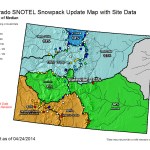
Click on a thumbnail graphic to view a gallery of snowpack data from the Natural Resources Conservation Service.

From the Valley Courier (Ruth Heide):

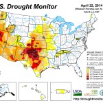
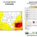
In light of the most recent snowpack report, the Rio Grande Basin is no longer at the bottom of the list in the state but it’s close.

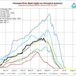
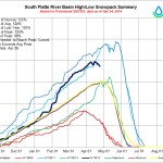
Colorado Division of Water Resources Division 3 Engineer Craig Cotten reported to the Rio Grande Water Conservation District board yesterday the Rio Grande Basin was 73 percent of average as of Monday morning, April 14. The basin, which encompasses the San Luis Valley, had been the lowest in the state for snowpack but is now barely above the Durango area, which sits at 71-72 percent of average, Cotten said.

“Most of the other basins in the state are above 100 percent,” he added.

This will be the sixth year in a row the Rio Grande Basin has registered a belowaverage snowpack, which will result in a below-average run off, Cotten explained. The basin had risen to a point slightly higher than the previous three years until about a week ago, Cotten said, when warmer temperatures hit and the snowpack dropped.

SNOTEL sites within the basin vary greatly, Cotten added, with snow measurements in the northern part of the Valley reflecting higher numbers than the southern part.

“Here in the basin, similar to the state as a whole, the northern streams are a little better than the southern streams,” he said.

The best, at 103 percent of average as of April 3, was Saguache Creek and the worst, at 35 percent of average, was the San Antonio River at Ortiz. On the same date, the Rio Grande at Del Norte stood at 80 percent of average , based on information from the USDA Natural Resources Conservation Services (NRCS), which operates the SNOTEL measurement sites. Cotten said NRCS has encountered budget crunches the last few years and has had difficulty maintaining their SNOTEL sites, with a move made to eliminate the manual snow measurement courses, but for the time being those are still in place. He said NRCS is looking for cooperators to help with funding the SNOTEL and snow course sites. Cotten added although NRCS has had trouble maintaining its SNOTEL sites, the data from the sites is “in the ballpark.” He said his office has nothing to prove them wrong but feels the data may not always be exactly correct. NRCS claims its data is good, he said.

Based on the NRCS forecast for April, the Rio Grande is predicted to run 505,000 acre feet this year, with 128,700 obligated to downstream states as part of the Rio Grande Compact. Since Colorado has already sent water downstream in January, February and March and will send more water downstream in November December, the amount calculated to be delivered during the irrigation season itself, April-October , is 42,000 acre feet, Cotten explained. To make that commitment, the water division will have to curtail irrigators by about 10 percent, he added. That is the current curtailment on the Rio Grande. The current curtailment on the Conejos River system is 6 percent, Cotten added. The April NRCS forecast for the annual flow on the Conejos system, which includes the Conejos River, San Antonio and Los Pinos Rivers, is 200,000 acre feet, with 45,000 acre feet obligated to New Mexico and Texas to meet the Rio Grande Compact . A great deal of that has been or will be sent downriver during wintertime, but the amount required to be sent downriver during the irrigation season is 11,000 acre feet. That accounts for the 6 percent curtailment.

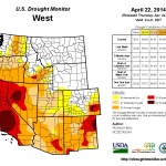
While Colorado’s Rio Grande Basin may reflect below-average numbers, New Mexico is in much worse shape with snowpack in places well under 50 percent of average and even less than 10 percent of average.

The reservoirs used to store Rio Grande Compact water are located in New Mexico, with the main reservoir storage at Elephant Butte Reservoir. Currently that reservoir has about 302,000 acre feet of compact usable water but is only seeing inflow of about 123 cubic feet per second (cfs), compared to the average inflow of more than 1,000 cfs, “so they don’t have much flow at all into the reservoir,” Cotten said. He added that once the irrigation season begins below the reservoir the water will diminish even more. New Mexico irrigators will begin irrigating below Elephant Butte in May. Cotten reminded the group that as long as Elephant Butte is below 400,000 acre feet which will be the case all year Colorado cannot store water in reservoirs built after the Rio Grande Compact was ratified. Those post-compact reservoirs include Platoro.

Regarding weather forecasts for the next three months May, June, July the Valley is showing equal chances of having average precipitation. That is better news than the last three years when the summer months reflected below-average precipitation forecasts for this area, Cotten said.

From the Aspen Daily News (Nelson Harvey):

As this winter’s banner snowfall helps refill mountain reservoirs drained by the historic drought of 2012, it’s also allowing administrators of at least two major trans-mountain diversion water projects in the Roaring Fork watershed to plan for larger-than-normal diversions to the Front Range this year.

The Fryingpan-Arkansas Project is expected to divert 73,000 acre-feet of water in 2014 from the headwaters of the Fryingpan River above Ruedi Reservoir to the Arkansas River basin on the East Slope. One acre-foot is equivalent to 325,851 gallons, and over the last 12 years, the project has diverted an average of 54,000 acre-feet, making this year’s projected diversion 35 percent larger than average.

The Twin Lakes Reservoir and Canal Company, which manages a four-mile-long tunnel piping water from the headwaters of the Roaring Fork River on Independence Pass to the Arkansas River basin, is also tentatively planning to divert between 53,000 and 55,000 acre-feet of water this year. According to Kevin Lusk, the president of the company’s board of directors, that’s as much as 20 percent more water than the project’s average annual diversion of about 46,000 acre-feet, most of it destined for the cities of Colorado Springs and Pueblo.

But at least one other trans-mountain diverter — the Pueblo Board of Water Works — is actually planning to pipe less water to the East Slope this year through the Busk-Ivanhoe tunnel above the Fryingpan than usual, since above-average snowpack in the Arkansas River basin should help the city meet its water needs…

Although peak runoff is likely weeks away, all three of the trans-mountain diversion projects in the Roaring Fork watershed are already piping water to the East Slope. On Sunday, a gauge at the Twin Lakes Tunnel’s entrance registered a flow of 22.3 cubic feet per second, or roughly 10,000 gallons per minute, heading into the tunnel. Similar gauges at the Boustead Tunnel (part of the Fryingpan-Arkansas project) and the Busk-Ivanhoe Tunnel registered flows on Sunday of 2.49 cfs and 1.43 cfs, respectively…

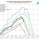
The ample water supplies that make historically large diversions possible also are aiding local reservoirs this year. Storage in the Colorado River basin’s reservoirs hovered around 93 percent of average on April 1, up from just 65 percent of average on the same date in 2013.

The storage picture is likely to improve even further in the coming months. Mage Hultstrand, a hydrologist for the National Resources Conservation Service, told a meeting of the Governor’s Water Availability Task Force in Denver this past Wednesday that snowpack in the Colorado River basin stood at 130 percent of average as of April 1. That early surplus means that the basin could still have an average water year even if it received just 83 percent of normal precipitation for the rest of 2014, Hultstrand said.

At last week’s task force meeting, officials charged with securing water for Front Range cities like Denver, Fort Collins and Colorado Springs said their own reservoirs already are between 80 and 90 percent full, even though peak spring runoff is likely more than a month away. The healthy storage numbers make it less likely — though not impossible — that Front Range cities will have to institute mandatory watering restrictions this summer like they did during the drought of 2012…

As residents of southern Colorado contemplate a high-risk fire season, people along the Front Range have another sort of natural disaster on their minds this spring: floods. Last September, flash flooding destroyed and damaged homes, roads, bridges and other infrastructure in 20 Front Range counties. Now, concern is running high that when runoff courses down through stream and riverbeds that were rerouted by last year’s floods, a second round of flooding could result.

Many Front Range communities are racing to get ahead of the threat by stabilizing stream banks, shoring up roads and putting other watershed protections in place before spring runoff kicks into high gear next month.

Robert Glancy, a meteorologist with the National Weather Service, told last week’s task force meeting that recent bouts of warm weather in the central mountains have helped jump start the spring melting process, drawing down the snowpack and reducing the likely strength of future floods.

“I’m glad that we’re melting now, because it’s wearing down the snowpack,” Glancy said.

From The Colorado Springs Gazette (Lance Benzel):

The snow that pounded Colorado’s high country all winter – delighting skiers with an extended season – looks poised to bring thrills to the state’s whitewater enthusiasts. Not to mention the businesses that put them in the water…

Cumulatively, the Arkansas River Valley is at 102 percent of the mean snowpack, or about average, according to the Natural Resources Conservation Service, which measures snowpack across the state. Hidden among those numbers is a much-better-than-average snowpack in waterways near the river’s headwaters, Hamel said, calling them a key indicator for good rafting. He said a high moisture content in the soil also will help generate runoff into the area’s waterways, bolstering water from snow melt.

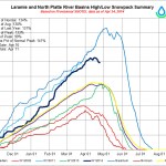
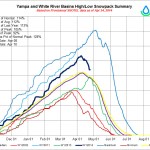
While the numbers are worth cheering, they’re nothing compared with the Laramie and North Platte river basins, which are at 139 percent of mean. The Yampa and White River basins are at 121 percent, the Upper Colorado River Basin is at 123 percent, and the South Platte River Basin is at 132 percent.

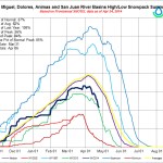
But heavy snowpacks are hardly universal. Missing out on the trend are basins in southern and southwestern Colorado, which suffered an anemic winter.

The Upper Rio Grande Basin is at only 67 percent of the mean, and the San Miguel, Dolores, Animas and San Juan river basins are at 73 percent.

Predictions about the health of the rafting season rest on hopes for mild temperatures early in the season. A rapid melt could mean bad news for rafting companies, which look for a stable, long runoff to keep flows moving into the peak tourist period, generally from mid-June to mid-August.

Dust picked up by storms in Utah, Arizona and New Mexico and then dumped on Colorado’s high country also can enter the mix, leading to quicker melts.

While the Colorado River Water Conservation District recorded at least eight large dust storms this winter, the state’s snow packs might be deep enough to weather effects of the dust, general manager Eric Kuhn said.

In some areas, including the Colorado River Basin, the deep snow might be a double-edged sword, sending outfitters on a hunt for waterways that aren’t dangerously high.

From CBSLocal.com:

Denver Water has been regulating its outflow at the Dillon Reservoir dam to get ready for all the snow to melt. Right now the output is around 700 cubic feet per second and there’s already one rafting companytaking advantage of all the water.

“Today is the start of our 2014 rafting season,” Campy Campton with Kodi Rafting said on Thursday.
It’s come about a week or two earlier than normal. The above average snowpack is starting to melt, and that means rivers are already moving…

“This is really early, especially for the Blue River, but we had some folks that are interested in boating today and we were coming out anyway, so we brought them along for the fun,” Campton said. “This is one of the few rivers in the state of Colorado that’s solely dependent upon dam release for the river to flow.
“We boated the Blue the last time in 2011. We saw enough water to come down here commercially and boat and have fun.”[…]

The River Outfitter’s Association said there are other places like the Animas River around Durango, the Colorado River near Glenwood and the Arkansas River around the Royal Gorge that are also seeing companies get an early jump on the season.

Drought news

Click on a thumbnail graphic to view a gallery of drought data from the US Drought Monitor. Click here to go to the US Drought Monitor website. Here’s an excerpt:

Summary

Weather systems moving in the upper-level westerly flow generated low pressure systems and surface fronts which moved across the contiguous United States (CONUS) this U.S. Drought Monitor (USDM) week. Two storm tracks resulted, with one moving across the northern tier states and the other from southern New Mexico, across the Gulf of Mexico coast, and up the East Coast. Above-normal rainfall was widespread across southern New Mexico, the Texas Trans Pecos, and the coastal Southeast. Below-normal precipitation dominated the rest of the country, with much of the Southwest again receiving virtually no precipitation. Weekly temperatures averaged above normal in the West and below normal in the East…

The Plains

Drier-than-normal weather dominated the Plains this week and much of the last 6 months. A colder-than-normal winter and early spring have delayed agricultural activities; April 21 USDA reports indicated that the condition of winter wheat has declined in Kansas, with winter wheat condition rated poor to very poor for 32% of the crop in Kansas, 12% in Nebraska, and 4% in South Dakota. The USDA rated topsoil moisture conditions short or very short (dry or very dry) for 72% of Kansas, 54% of Nebraska, 50% of Colorado, and 23% of South Dakota. D0 expanded across eastern South Dakota to reflect dryness at the 30-day to 6-month time scales. Most of Kansas and Nebraska were already in moderate to extreme (D1-D3) drought, but an oval of D3 was added in central Kansas and D2 expanded eastward from there to reflect extreme low precipitation values at 30-90 days, as well as poor USDA soil moisture and crop condition reports. In southeast Colorado, D3-D4 expanded while the western edge of D0-D1 contracted. The D3 expansion in southeast Colorado bled into western Kansas…

The West

Parts of the coast and Cascades of Washington were wetter than normal this week, with stations receiving 3 inches or more of precipitation, and some locations reporting over 5 inches. An inch or two of precipitation was widespread over western Oregon, yet the week ended up drier than normal. Parts of the northern and central Rockies received an inch or more of precipitation, which was above normal in places. An upper-level system dropped a third of an inch to an inch of rain over southern New Mexico, which was above normal for the week. Otherwise, precipitation amounts were half an inch or less, with the southwestern third to half of the West receiving no precipitation. Mountain snowpack was below normal, except for the Washington ranges and northern and central Rockies, with continued warmer-than-normal temperatures accelerating the melting of the meager snowpack in the California Sierras.

In Arizona, livestock water tanks were dry so water hauling was an issue on ranges that don’t have water improvements with pumps, tanks, and pipes. D2-D3 expanded in southeast Arizona where stream levels continued to fall and evaporation was high. A very high fire danger and low precipitation at long (multi-year) time scales prompted the expansion of D1 in southwest Arizona and adjoining California and conversion of the S impact indicator to SL. In New Mexico, wetness in July and September 2013 masked longer-term dryness. October 2010-March 2014 was the third driest such 42-month period in the 1895-2014 record; it would be the driest if not for the July/September rains. Another dry week combined with this long-term dryness to expand D4 in northeast New Mexico. In Nevada, D3 expanded in Nye and adjacent Mineral counties, and the D1 donut hole was eliminated in southeast Nevada. The L impacts boundary along the Colorado-Utah-Wyoming boundary was pulled back where soil moisture deficits and short-term precipitation deficits indicated the SL timescale squeezing the L impacts region.

D2 and D3 expanded in northern California and parts of southern Oregon, with D2 spreading along coastal Oregon up to Lake County where precipitation deficits and low streamflows were most significant. D4 expanded further in the San Francisco Bay area and across all of Monterey County. In California, the city of San Diego was proposing a water supply “level 1” status, and a small reservoir/water district in Riverside County was on the 30-90 day “watch” list for depleted supplies. The San Antonio Reservoir has been essentially dry through the entire winter and Nacimiento Reservoir was at 22% capacity. The City of Montague risks running out of drinking water by the end of summer and has requested that all outside watering be curtailed until further notice; this is the first time in over 80 years of water deliveries from the Montague Water Conservation District (MWCD) that this situation has occurred. Growers in Shasta Valley with the primary irrigation district (MWCD) were expected to have only enough irrigation water to irrigate what would equate to a single irrigation on about half of their acreage. Many growers in the Big Springs area have already started pumping water to irrigate field. Within 24 hours of when one grower started irrigating, two nearby domestic wells went dry. The frustration caused by the drought can be seen in a report by an observer in Siskiyou County: “Our snow pack is pathetic, rainfall is way below normal, (low) stream flows are running at 2-3 months ahead of normal depending on the area, well levels have dropped severely and many wells are dry in spring or have levels typical of late fall, surface water irrigation supplies are non-existent to extremely limited in many areas, and the situation is only getting worse daily (especially after 3 consecutive years of drought).” With the expansion of D1 across southeast California and southwest Arizona, this week marks the first time in the 15-year history of the USDM that 100% of California was in moderate to exceptional drought…

Looking Ahead

The NWS HPC 7-Day Quantitative Precipitation Forecast (QPF) calls for frontal-low pressure systems to bring an inch or more of precipitation across a large part of the country, stretching from the eastern and northern Great Plains to the Appalachians, with 3 inches or more across parts of the Midwest to Deep South. Another area of 2+-inch precipitation is projected for coastal Washington and Oregon, and parts of the northern Rockies, while the Southwest is expected to remain mostly dry. Temperatures for the April 24-30 period are predicted to be warmer than normal in the southern states ahead of the front, with colder-than-normal air from the north moving across the country behind the frontal systems.

The 6-10 day and 8-14 day outlooks indicate that an upper-level circulation pattern, consisting of a ridge over western North America and a trough over the east, is predicted to become entrenched during May 1-7, bringing colder-than-normal temperatures to the country east of the Rockies and warmer-than-normal temperatures to the West and Alaska. This period should be drier than normal for the Southwest and Great Plains into the Midwest, and wetter than normal across the Southeast, Ohio Valley, Northeast, and part of the Pacific Northwest. Southern Alaska is expected to be wetter than normal with northwest Alaska drier than normal.

Arkansas River Basin Water Forum recap

Arkansas River Basin -- Graphic via the Colorado Geological Survey
Arkansas River Basin — Graphic via the Colorado Geological Survey

From The Pueblo Chieftain (Chris Woodka):

Water that farmers have relied on in the past was not available during last year’s drought. While some water was available in the 2012 drought, two years was too much for the Arkansas Valley That should be a wakeup call for the future, Division 2 Engineer Steve Witte told the Arkansas River Basin Water Forum Thursday.

“Obviously, drought reduces the water that’s available for replacement,” Witte said.

Farmers need replacement water in order to pump wells, and now to operate sprinklers fed from surface ponds. That competition is increasing. A study for the Lower Arkansas Valley Water Conservancy District showed that the replacement water needs will double by 2050, as more farm improvements are needed. Right now, farmers use about 25,000 acre-feet (an acre-foot is 325,851 gallons) to augment wells and sprinklers. That could grow to a need of 50,000 acre-feet by 2050. But Witte presented figures that showed an even greater need already in place. From 2002-13, farmers used 39,000 acrefeet annually. About half of that came from drying up other farms. For the remainder, farmers relied on return flows from the Fryingpan-Arkansas Project or leases from cities, primarily Pueblo, Colorado Springs and Aurora. As the cities grow into their supplies, that water will be less frequently available.

Meanwhile, the Lower Ark district is helping farmers cope with increased water needs, supplying engineering and water resources. In the future, lease fallowing programs like the Arkansas Valley Super Ditch could meet some of the needs. Other strategies include groundwater recharge ponds, finding a way to use state-line credits to Kansas, securing Fry-Ark flows and improving on-farm conservation, Witte said.

“Can this continue?” Witte asked. “Where the water will come from, I don’t know.”

From The Pueblo Chieftain (Chris Woodka):

Water is critical to the Lower Arkansas Valley and must be protected from threats — economic, meteorological or political. That was the upshot at the final day of the Arkansas River Basin Water Forum Thursday at Otero Junior College.

“We’re continuing to go down a road the valley should be concerned about,” Beulah rancher Reeves Brown said, talking about past raids on valley water by cities. “If we can be a little more responsible about planning for the future, rather than taking what happens, we need to do that.”

The sentiment resonated throughout the room, with most heads nodding in agreement. At times it seemed the group was ready to boil into a march for the cause.

“Just because other areas of the state are exploding, why should they take the resources away from farms?” one woman commented. Others echoed the comments, with some urging more action and less talk.

Mostly, however, the meeting was a recitation of studies and opinions that indicate water will be an ever more precious commodity in the future.

Jay Winner, executive director of the Lower Arkansas Valley Water Conservancy District, said an upcoming study shows that agriculture is a $695 million business employing more than 4,600 people in the Arkansas River basin. On top of that, agricultural incomes contribute $317 million in spinoff benefits, while the recreation industry realizes $220 million in revenues because of agricultural water flowing in the Arkansas River. It also shows that for every 1 percent of water removed from the valley, there would be an economic hit of about $10 million.

Families also would suffer with the loss of irrigation water, said Michael Hirakata, whose great-grandfather came to Rocky Ford from Japan. Hirakata still runs the family farm, and he plans to turn it over to his children.

“We think we can’t live without our phones, but water is imperative,” Hirakata said. “I owe it to my ancestors to keep farming with my family in the Arkansas Valley.”

Las Animas County rancher Steve Wooten, one of the leaders in the fight against Pinon Canyon expansion by the Army, said political attempts to hamstring farmers also must be stopped.

Outside groups are sponsoring ballot initiatives that purport to encourage humane treatment of animals, but actually interfere with how ranchers make their living, he said.

“The most challenging thing to agriculture is not growth or drought, but political activism,” Wooten said.

From the La Junta Tribune-Democrat (Bette McFarren):

Water officials from all over Colorado gathered Wednesday at Otero Junior College Student Center for the 20th Arkansas River Basin Water Forum. Keynote Speaker was James Eklund, director, Colorado Water Conservation Board. His subject was “Colorado’s Water Plan.” “Basin Perspectives on Colorado’s Water Plan” was a panel moderated by John Stulp, Special Policy Advisor on Water to the Governor.

The Bob Appel Friend of the Arkansas Award went to Greg Policky, a biologist who worked to establish a high-quality fishery on the Upper Arkansas River. “His attention to detail and collection of objective fishery data has provided numerous benefits to the river’s fishery,” said Jean Van Pelt. He works with angling organizations and land resource agencies, but is most rewarded by working with school-age children.
Luncheon speakers Erin Mink and Brian McCain spoke on “Federal Water Rights Bills and Impacts to Colorado’s Water Supply.” Mink is from the office of Senator Mark Udall and McCain is from the office of Congressman Scott Tipton.

The “How Did We Get Here?” panel had some familiar faces for the people of Otero County: Moderator Gary Barber, West Water Research; James Broderick, Southeastern Colorado Water Conservancy District; Jay Winner, manager of Lower Arkansas Valley Water Conservancy District; Terry Scanga, Upper Arkansas Water Conservancy District; Jeris Danielson, Purgatoire River Water Conservancy District. Broderick will be remembered as the creator of the financial structure which enabled the financing of the Arkansas Valley Conduit. Winner is the spokesperson for the Super Ditch and the Rule 10 Plan, which hold out hope for an alternative to buy and dry for local farmers and a way to adjust augmentation water due to Kansas which allows farmers to use sprinklers and drip irrigation. Scanga is a specialist in the upper Arkansas, where water is brought over from the Western Slope. Danielson is from the Purgatoire basin, about 20 miles south of La Junta.

Scanga urged that all the water districts and entities work together for the common goal of good water for Colorado. Danielson and Winner stressed the importance of water storage and distribution. Broderick emphasized the financial aspect of planning: use the infrastructure you already have as much as possible. The alternative is “sticker shock” in utility bills. “Projects are expensive,” he reiterated. They all considered underground storage a possibility which would mean less loss to evaporation, as well as pipelines.
The next panel, “Where Do We Go Next?” was also moderated by Barber and featured Mark McCluskey, CDM Smith; Mark Shively, Conservation Consultant; Kyle Hamilton, CH2M Hill; and Mark Shea and Brett Gracely of Colorado Springs Utilities. Colorado Springs faces a huge issue in flood control.

More Arkansas River Basin coverage here.