The April newsletter from Protect the Flows is hot off the presses #ColoradoRiver

Pulse flow tongue upstream of San Luis Rio Colorado

Click here to read the newsletter. Here’s an excerpt:

In late March an agreement between the US and Mexico to release water to the parched delta region was realized with water from the Morales Dam released in a “pulse flow”. This release provided water to the region that has been dried up and experienced desertification over years of a lack of Colorado River water reaching the sea. The event received a great deal of media attention including amazing coverage by National Geographic. This was a perfect example of a variety of interests working together to achieve a solution that benefits the environment, the economy and the interests of 2 nations.

More Colorado River Basin coverage here and here.

Happy Earth Day: How did Earth Day come to exist?

cuyahogariverfire1131952

From NOAA:

On June 22, 1969, the Cuyahoga River on the southern shores of Lake Erie caught on fire as chemicals, oil, and other industrial materials that had oozed into the river somehow ignited. Just a few months before, on January 28, 1969, an oil rig leaked millions of gallons of oil off the coast of Santa Barbara. That same year, reports surfaced that our national symbol, the bald eagle, was rapidly declining as a species due to the chemical DDT, while around the world, whales were being hunted nearly to extinction. These and other incidents caught the attention of the national media and galvanized public awareness of the many environmental insults being hurled at the nation and the planet.

In response to the public outcry, Earth Day Founder Gaylord Nelson, who served as the Governor of Wisconsin (1958-1962) and in the U.S. Senate (1963-1981), organized a nationwide “teach-in” about environmental issues to take place on April 22, 1970. More than 2,000 colleges and universities, 10,000 public schools, and 20 million citizens participated—nearly 10 percent of the U.S. population at that time.

This outpouring of grassroots environmental activism marked the first Earth Day—a recognition of the importance of caring for the environment and accepting stewardship responsibility for the nation’s resources. It also helped establish a political climate conducive to forming both the National Oceanic and Atmospheric Administration (NOAA) and the U.S. Environmental Protection Agency (EPA) on October 3, 1970.

We like to say that “Every day is Earth Day at NOAA.” But ever since April 22, 1970, people the world over take time to recognize the importance of protecting the Earth’s natural resources—be they oceanic, atmospheric, terrestrial, or biological—for future generations.

National Climatic Data Center Global Analysis March 2014

significantclimateanomaliesandeventsmarch2014noaa

Click here National Climatic Data Center Global Analysis website hosted by NOAA. Click on the thumbnail graphic above for selected events. Here’s an excerpt:

Global Highlights

  • The combined average temperature over global land and ocean surfaces was the fourth highest for March on record, at 0.71°C (1.28°F) above the 20th century average of 12.3°C (54.1°F).
  • The global land surface temperature was 1.33°C (2.39°F) above the 20th century average of 5.0°C (40.8°F), the fifth highest for March on record. For the ocean, the March global sea surface temperature was 0.48°C (0.86°F) above the 20th century average of 15.9°C (60.7°F), tying with 2004 as the fifth highest for March on record.
  • The combined global land and ocean average surface temperature for the January–March period (year-to-date) was 0.60°C (1.08°F) above the 20th century average of 12.3°C (54.1°F), the seventh warmest such period on record.
  • Snowpack/runoff news: “At this point we [Denver Water] do expect that our reservoirs will fill” — Stacy Chesney #COdrought #ColoradoRiver

    Statewide snow water equivalent as a percent of normal April 21, 2014 via the NRCS
    Statewide snow water equivalent as a percent of normal April 21, 2014 via the NRCS

    From CBSDenver4.com:

    The mountain snow is melting and it looks like Colorado’s white winter in the high country will bring good news for residents along the Front Range. Denver Water thinks Dillon Reservoir will fill to capacity for the first time in years.

    It was the end of March last year when Denver Water put in Stage 1 water restrictions as Lake Dillon was only 65 percent full. As on Monday it’s at about 85 percent full and it’s actually being drained to get ready for more melting snow, which will mean even more water.

    “It’s always a balancing act with our reservoirs across the state — Dillon in particular. We want to ultimately keep it full so people can enjoy recreation on the reservoir, but we have to be really conscious too as to what happens below the reservoir,” Stacy Chesney with Denver Water said.

    With the snowpack well above average surrounding the largest reservoir that sends water to Denver, officials have been planning all winter to let some go.

    “We’ve been proactively releasing water into the river below to create that room to help reduce any risk of flooding that could happen later in the season,” Chesney said.

    But officials from Denver Water are keeping an eye on the snowpack with the hope of having full reservoirs for the first time since July of 2011.

    “At this point we do expect that our reservoirs will fill and we hope that customers will continue that wise water use and not overuse water and follow our watering rules which will start on May 1,” Chesney said.

    What many people in the high country are going to be watching is a layer of dust on the Western Slope that has sat on the snow for nearly a month. That, along with rain and warm temperatures over the last week, helped rush the melt over the past few days.

    From Steamboat Today (Scott Franz):

    This week, the persistent snow in the mountains just outside Steamboat Springs is reminiscent of the impressive snowpack of 2011, when the Yampa River overran Bald Eagle Lake and caused the youth minister at the Steamboat Christian Center and his family to evacuate their parsonage.

    Is spring 2014 another 2011 in the making? It’s unlikely, according to a hydrologist with the National Oceanic and Atmospheric Administration who keeps close tabs on the Yampa River Basin.

    Ashley Nielson confirmed that the total volume of water that flowed down the Yampa in 2011 beginning on April 1 and continuing through July 31 was the highest on record. And this year’s snowpack doesn’t measure up.

    “We do see a 10 percent chance the peak flow on the Yampa will go over flood stage, but it’s totally dependent on what kind of spring we have and how that snow comes off,” Nielson said Monday. “There’s a lot less snow than what we had in 2011.”

    The Natural Resources Conservation Service is reporting that the snow at the top of Buffalo Pass is currently 134 inches deep, which is down from 149 inches April 14, and the snow water equivalent is 112 percent of median. That compares to a record 180 inches of snow depth that stood at 130 percent of average in 2011. At the west summit of Rabbit Ears Pass on Monday, the snow water equivalent was 150 percent of median compared to 157 percent April 23, 2011…

    Still, the hydrograph for this week closely mirrors 2011, Nielson agreed, when low elevation runoff peaked on April 23. Nielson’s office is forecasting that the Yampa will shoot up Wednesday at about 1,900 cfs, then slip back to the range of 1,000 to 1,200 cfs through the end of the month when a cold front is expected to apply the brakes. It’s very typical, she said, for the Yampa to rise steeply in late April as snow melts suddenly from the valley floor and lower slopes.

    Has Durango sold its river, and its soul, to recreation? — High Country News

    Design for the whitewater park at Smelter Rapids via the City of Durango
    Design for the whitewater park at Smelter Rapids via the City of Durango

    From the High Country News (Jonathan Thompson):

    The City is building a park. On the river. With a boat ramp…

    As upsetting to opponents as the development itself is what it will bring: More of the inner-tubing, paddle-boarding, river-rafting, beach-partying masses that have already colonized large swaths of the river during the warmer months of the year. But it’s also what the development represents. In its quest to be an amenity-rich, recreation-based town rather than the extraction based one it once was, critics say, Durango has finally gone too far.

    The problem park — its name is Oxbow Preserve — consists of 44 acres of land just north of this town of 15,000 people. The City acquired the land from private owners back in 2012 with the help of $400,000 in statewide lottery funds that are doled out for such things. Generally speaking, the land acquisition itself wasn’t controversial: It would preserve a nice stretch of the river as open space with public access, benefit wildlife and allow the City to stretch the riverside bike path further afield.

    After acquiring the land, the City announced that it would keep its hands off 38 acres, leaving it as open space and wildlife habitat. No worries there. Yet the remaining six acres would be developed as a park, with not only the bike path going through, but also a driveway, parking lot, restrooms and a boat ramp, accessible to commercial outfitters. This development — the ramp in particular — is what’s fueling the fight.

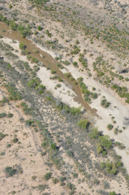
    The Animas River has always been critical to this southwest Colorado town. Its cold waters come crashing violently out of the narrow, v-shaped gorge that slices through the San Juan Mountains. When it hits the flat-as-glass bottom of the glacially-carved Animas Valley, it slows suddenly, and its path becomes a lazy meander, almost twisting around and meeting itself at times. The sandy banks here are so soft that ranchers used to line them with crushed, old cars to prevent erosion…

    Commercial river rafting got going here in the early 1980s, and has since grown into a decent-sized chunk of the local tourism trade. Back in 1990, commercial outfitters ferried some 10,000 folks down the town run. By 2005, the peak year so far, that had jumped to 52,000. In 2012 — a low water year — 38,000 paid to raft the river, making a $12 million economic impact on the community, according to a Colorado Rivers Outfitters Association Report…

    At least as many people float the river without guides, including private rafters, kayakers, paddle boarders and inner-tubers. Drought actually draws more of these users, since the river is safer at low levels.

    Around the river access points, cars crowd the streets on summer days and inner-tube- and Pabst Blue Ribbon-hefting, scantily-clad youngsters wander around lackadaisically among the exhaust-belching rafting company buses, crammed to the gills with tourists getting the safety talk while wearing oversized, bright-orange life jackets. Downriver, a nice slow-moving section morphs into a party zone, replete with blaring sound systems.

    A large chunk of opposition to the Oxbow park plans — particularly the commercial boat ramp and developed parking lot — comes from nearby property owners, worried that the in-town riverside zoo will simply migrate upstream to their backyards. But the resistance is not all rooted in NIMBYism. Also of concern are the impacts the floating and beach-going masses will have on wildlife — the park is near a pair of great blue heron rookeries, elk habitat and bald eagle fishing areas. Still others see the inclusion of a commercial boat ramp as a subsidy for private enterprise, and as a violation of the terms of the state funds that paid for the parcel of land. The developed park has its supporters, too: Commercial river rafters would be able to stretch out their town run, as well as the rafting season (the sandy upper reaches of the river are navigable even in very low water). And they contribute to the economy — many of my friends paid their way through college and beyond as river guides.

    More Animas River watershed coverage here.

    Jamestown recovery from #COflood

    From the Mountain Town News (Allen Best):

    Mayor Tara Schoedinger says 80 percent of the [Jamestown’s] 300 residents remain displaced. They’ve rented houses in Boulder, Longmont, or elsewhere. This winter, Schoedinger feared few would return if water service and roads were not restored by August.

    Now, it looks like they will. Bids will soon go out for design and construction of restored infrastructure of water treatment, mains and service lines. If all goes as planned, construction will begin in late May or early June. Completion is expected by August.

    For repairs above ground, the town’s insurance will pay for replacements. But for the more costly below-ground work, the Federal Emergency Management Agency will pay 75 percent of costs and the state of Colorado 22.5 percent.

    That leaves the town paying just 2.5 percent. This is expected to cost just under $2 million.

    In an interview at the Boulder County Courthouse, where the town board has met since last September, Schoedinger recently explained that temporary roads associated with the water works will be completed by early August, with one significant bridge repair likely to be done by November.

    As before, sewage treatment is handled through individual septic tanks, and $50,000 has been donated to that cause.

    Roots of the settlement are traced to 1863, when evidence of gold nearby drew prospectors. It’s the most northerly extent of the belt of gold and other precious metals that sweeps across Colorado to the Durango area. The gold never amounted to that much, but the town stayed.

    This isn’t the first challenge. Schoedinger describes floods in the late 1800s, then again in 1913 and 1969—and with at least comparable ferocity to that which occurred in September.

    Jamestown was probably drenched worse than any other town in the four days of storms that dropped up to 18 inches in some locations. The flooding waters destroyed 20 percent of the houses and 50 percent of roads, plus the water treatment plant and the fire station. A mudslide also killed Schoedinger’s next-door neighbor, Joey Howlett, who was regarded as the town’s patriarch.