Snowpack news

From the Sky-Hi Daily News:

The USDA Natural Resources Conservation Service Kremmling Field Office snow surveyors Mark Volt, Noah Bates took the April 1 snow survey measurements during the last days of March. Snowpack for Middle Park and the upper Colorado River Basin stands at 144 percent of average, compared to 79 percent last April 1, 2013. The snowpack surpasses the 135 percent reading in the height of the year of 2011, and 62 percent in the drought year of 2002.

Snowpack in the mountains above Middle Park now ranges from 114 percent to 206 percent of the 30- year average.

The Granby snow course near C Lazy U Ranch, which has been read since 1949, set a new record high for the second month in a row. Snow density is averaging 31 percent, which means that for a foot of snow there are 3.72 inches of water. Irrigators, towns, river runners and other water users can expect higher than normal river levels this summer.

Reservoir storage remains higher than last year. From this point on, spring runoff will be highly dependent on melting conditions (i.e., temperature and wind), as well as spring snow accumulation and/or rainfall.

Most of the snow courses around Middle Park have been read since the 1940s. Snow course readings are taken at the end of each month, beginning in January and continuing through April. March is historically the snowiest month, and the April 1 readings are the most critical for predicting runoff and summer water supplies, as most of our high country snowpack peaks around that time. Manual snow courses will be read for the final time this year at the end of April.

For further information, including real-time snow and precipitation data for SNOTEL (automated Snow Telemetry) sites, visit http://www.co.nrcs.usda.gov/snow/index.html.

Colorado legislative committee OKs oil and gas health impact study — Denver Post #COleg

Gunnison Basin Rountable basin implementation plan focuses on agriculture #COWaterPlan

haymeadowsneargunnison

From the Glenwood Springs Post Independent (Hannah Holm):

Current efforts to develop a Colorado Water Plan have been largely driven by a large projected gap between urban water needs and developed supplies. Gunnison Basin water planners, however, are more focused on a current gap between agricultural needs and developed supplies. The water managers and stakeholders that make up the Gunnison Basin Roundtable are concerned that efforts to address the urban gap will negatively impact agricultural uses, whose importance goes beyond food production to environmental and recreational values.

In the Gunnison Basin, which stretches from the headwaters near Crested Butte, Lake City, Ouray and Paonia downstream to Delta and Grand Junction, the anticipated gap between municipal needs and developed supplies is relatively small, while the gap between agricultural needs and supplies is already large.

According to the latest statewide water supply study, the present gap between water requirements to fully meet crop demands and water available is about 128,000 acre-feet per year in the Gunnison Basin. An acre-foot is about enough water to fill a football-field-sized tub one foot deep. This is generally considered sufficient to sustain two to three average households for a year.

Agricultural water shortages are experienced in every water district in the basin. The district that includes the North Fork of the Gunnison River and Delta has the largest gap at over 75,200 acre-feet per year. This district also has the largest number of irrigated acres in the basin, with 90,200. The Lake Fork and Lower Uncompahgre districts have the smallest gaps, at between 2,500 and 3,000 acre-feet per year. The farmers of the 79,800 irrigated acres in the Lower Uncompahgre District benefit from senior water rights and upstream reservoirs, while the Lake Fork District contains just 16,500 irrigated acres.

Analysis conducted so far points to a need for additional upstream reservoir storage to support late-summer and fall irrigation. The Wilson Water Group, the consulting group hired by the Gunnison Basin Roundtable to assist with the basin plan, is conducting targeted technical outreach meetings to more precisely identify the causes of the shortages and identify potential projects to address them. Causes for shortages can be categorized as physical (insufficient water available), legal (water is present, but the irrigator doesn’t have rights to it), storage-related (insufficient late-season water), or efficiency-related (sufficient water could be available if managed more efficiently).

The focus on agriculture in the Gunnison Basin makes sense, given that the Gunnison Basin Roundtable’s primary goal is to ā€œprotect existing water uses in the Gunnison Basin.ā€ Agriculture (mostly grass and alfalfa hay, but also pasture, fruit trees, wine grapes and the famous Olathe Sweet Sweet Corn) accounts for approximately 90 percent of the basin’s water consumption. In addition to its intrinsic value, irrigated agriculture is also seen as supporting other valuable attributes of the basin’s landscape. It provides the aesthetic ā€œopen spaceā€ important to the basin’s growing recreational economy, and the flood irrigation for high hay meadows slows the flow of water downstream, supporting late-season streamflows. Flood irrigation also creates wetland areas that nurture birds and other wildlife.

Additional goals, supporting that primary goal of protecting existing water uses, include addressing municipal and industrial shortages, quantifying and protecting environmental and recreational water needs, and maintaining and modernizing critical water infrastructure, including hydropower.

The Gunnison Basin Roundtable has also put forward a number of ā€œstatewide principlesā€ for consideration by other basin roundtables. These principles warn of the hazards of new water projects on the Western Slope and encourage conservation and the development of local projects to meet local needs. Those principles are a response to the perception that Basin Roundtables in basins east of the Continental Divide continue to look west for new water supplies, despite the fact that additional depletions from the West Slope could increase the risk that Colorado may not be able to meet its contractual obligations to the downstream states that share the Colorado River.

The basin roundtables are working to collect public input on water needs and priorities as well as to technically analyze supplies and demands. In order to learn more and take a survey to contribute your insights, go to http://www.ugrwcd.org and click on ā€œGunnison Basin Water Plan.ā€

More Colorado Water Plan coverage here.

IBCC meeting recap: Front Range may not seek “annual firm yield” from future projects #ColoradoRiver #COWaterPlan

Colorado transmountain diversions via the State Engineer's office
Colorado transmountain diversions via the State Engineer’s office

From Aspen Journalism (Nelson Harvey):

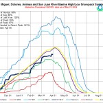
Mark Waage, the manager of water resources planning for the utility Denver Water, told a meeting of the Interbasin Compact Committee (IBCC) in Denver that Front Range interests are not necessarily seeking ā€œfirm yield,ā€ or reliable annual supply, from a new trans-mountain diversion project, but instead could settle for diverting water only when a wet winter like this one gives the Western Slope and downstream consumers more than they need to satisfy existing water rights.

ā€œWe are looking for wet year water,ā€ said Waage after the meeting. ā€œThere are going to be wet years when we can develop more water. In dry periods, this project wouldn’t divert from the Colorado [River], and we would rely on [buying water rights from] Front Range agriculture instead,ā€ along with reservoir and groundwater aquifer storage and mechanisms like rotational fallowing that permit farmers to temporarily lease their water rights to cities.

The suggestion by Front Range interests that they’re willing to forego diversions during dry years stands in sharp contrast to their usual and long-standing insistence that ā€œfirm yieldā€ for the Front Range from new trans-mountain diversion projects is inevitable.

Existing diversion projects — like the Twin Lakes tunnel underneath the Continental Divide between the Roaring Fork and Arkansas river basins — already have the capacity to pipe as much as 600,000 acre-feet (roughly six Ruedi Reservoirs) of water to the Front Range each year…

Just how much of the ā€œnew supplyā€ sought by the Front Range will come from the Western Slope remains a looming question as officials work to draft a statewide water plan as ordered by Colorado Gov. John Hickenlooper last year…

In the meantime, members of the IBCC will now take the emerging framework for a new trans-mountain diversion project back to their respective roundtables for input, before drilling down further on the details in future meetings.

Any agreement on a new project that parties on opposite sides of the Continental Divide can hammer out will likely be reflected in the statewide water plan. Still, the plan itself won’t explicitly endorse any proposed new projects.

ā€œWe’re not going to pick winners and losers, or projects that are given a green light, so to speak, or a red light, so to speak,ā€ said James Eklund, the executive director of the Colorado Water Conservation Board, which oversees the IBCC and the roundtables.

Eklund spoke at a meeting with state legislators on the statewide water plan that took place in February. ā€œInstead what we’d like to do,ā€ he said, ā€œis focus on a regulatory path where we might be able to someday have the state endorsement of a project.ā€[…]

For the IBCC members charged with protecting water supplies on the Western Slope, who have long clashed with Front Range cities over the idea of new trans-mountain diversion projects, Waage’s modest statement last week on behalf of Denver Water— vague and general though it was — sounded like something of a breakthrough.

ā€œThey are now willing to talk about a project that’s not going to divert every year, and that’s new,ā€ said Jim Pokrandt, communications and education director for the Colorado River District, which protects Western Slope water interests. ā€œThere seemed to be a coalescing around a project that would only work intermittently.ā€

Eric Kuhn, the Colorado River District’s general manager, said that although Front Range water interests have long hinted that they might accept a new trans-mountain diversion project that doesn’t pull water every year, ā€œthis is the first time that the idea has surfaced with some consensus.ā€[…]

Specifically where a new trans-mountain diversion project would be located also remains to be seen. Front Range interests have proposed several possibilities in recent years, including projects pulling anywhere between 100,000 and 250,000 acre feet from the Green River at Flaming Gorge Reservoir in Wyoming, from the lower Yampa River, or from the Gunnison River at Blue Mesa Reservoir west of Gunnison…

Since many of the water rights now used by the Front Range to divert Western Slope water under the Continental Divide were adjudicated after 1922, there’s a chance that a so-called ā€œcompact callā€ would force some Front Range water interests to stop diverting water temporarily.

Faced with the insatiable demand of their urban customer base, those Front Range interests could then begin leasing water from farmers on the Western Slope in order to continue their usual diversions, extending into western Colorado the practice of ā€œbuy and dryā€ water transfers from farms to cities that is now common on the Front Range.

To alleviate fears of such a scenario playing out, Waage of Denver Water told the IBCC meeting last week that the Front Range would be willing to assume the ā€œhydrologic or legal riskā€ associated with a new diversion project, meaning that diversions from the project would cease in the event of a compact call before Western Slope water users with more senior rights had to curtail their own use.

ā€œThe risk of compact curtailment has been a stumbling block for years, and we are looking now at how to minimize and share that risk,ā€ said Waage. ā€œWe need to look at water projects that won’t lead to the curtailment of the Western Slope’s Colorado Compact allocation.ā€[…]

ā€œI think to decide whether there is enough water, the Front Range would have to do a very detailed risk analysis,ā€ said Kuhn of the Colorado River District. ā€œBecause of climate change, we know that the [water supply] baseline is going to change. I think most of the science suggests that we will not have more water in the future than we do now.ā€

More Colorado Water Plan coverage here.

Colorado Springs Utilities has acquired most of the land access needed for the Southern Delivery System

Southern Delivery System route map -- Graphic/Reclamation
Southern Delivery System route map — Graphic/Reclamation

From the Colorado Springs Independent (Pam Zubeck):

Outside of a handful of parcels tied up in eminent-domain court actions, the city has amassed the vast majority of land needed to complete the 66-inch-diameter line across Pueblo and El Paso counties. And as for those in court, Utilities has been granted possession; at issue is determination of their value.

Which leaves only one other property acquisition needed for the pipeline itself, and a couple dozen others for related projects. Overall, the land-acquisition project is on schedule, if significantly over budget.

“We are pleased to be nearly complete with acquiring the land needed for SDS,” says Utilities project manager John Fredell in a statement. “We have worked hard to be fair with property owners and appreciate their cooperation to advance this critical project for our community and partners.”[…]

The city’s initial foray into acquiring property for the project, in 2003 and 2004, caused an uproar, and a tightening of city real estate acquisition procedures. Utilities, in some cases without Utilities Board approval, had made offers for homes near Jimmy Camp Creek, northeast of the city, for up to three times the homes’ assessed values, plus six-figure moving costs — in one case, $340,000. The city paid $6.1 million for 14 properties and then allowed the former owners to rent for $300 a month indefinitely.

Within a few years, the city abandoned the Jimmy Camp area as a reservoir site due to archaeological values and other factors, and instead chose Upper Williams Creek near Bradley Road.

In 2009 and 2010, Utilities tangled with Pueblo West residents and left some hard feelings in its wake. The buried pipeline, which traverses the back portions of residential lots, can’t be built upon, which residents say renders their yards unusable.

Resident Dwain Maxwell, who’s forced Utilities into condemnation court, says he was paid $1,850 for land his appraisal said was worth $16,500. Meanwhile, he estimates Utilities has spent four times that amount on attorneys. “I feel like they’ve not been honest with us,” he says today.

Gary Walker of Pueblo County is also still in condemnation court with the city, and declined to be interviewed for this story. But he notes in an email that he’s been recognized repeatedly for his stewardship of the land at his ranch, and was the first to sign up for the reintroduction of the black-footed ferret under federal rules. “How do you put a price on the destruction of something so important as our environment?” he asks.

In 2012, Utilities went up against the Norris ranching family for a chunk of land for Upper Williams Creek Reservoir. After the Norrises moved to create their own reservoir, a deal was reached in which the city paid the family $7.5 million for 791 acres.

But the biggest single acquisition was land next to the Norris property owned by the State Land Board. The city paid more than $11.8 million for 1,128 acres, the highest per-acre price paid for pipeline property…

Utilities needs to acquire about 15 additional properties for the reservoir site, but the reservoir won’t be built until SDS’ second phase, from 2020 to 2025, as demand requires. The city also needs 11 more properties for a section of pipe for treated water, Rummel says.

So far, the city has spent $34.6 million on land for SDS. That’s about 38 percent more than the $25 million estimate in 2009 for 274 parcels in Phase 1 and reservoir land. If costs for surveys, appraisals, real estate fees and closings are added, the cost is $45 million, or 22 percent more than the 2009 “all-in” estimate of $37 million.

Water rates, meantime, haven’t increased as much as earlier predicted. Ratepayers saw 12 percent hikes in 2011 and 2012, and 10 percent increases in 2013 and 2014. A 5 percent hike is expected in 2015. Previously, 12 percent annual jumps were forecast from 2011 through 2017.

More Southern Delivery System coverage here and here.