Click here to read the current assessment from the Colorado Climate Center. Click here to go to the NIDIS website hosted by Colorado Climate Center.

Click here to read the current assessment from the Colorado Climate Center. Click here to go to the NIDIS website hosted by Colorado Climate Center.

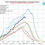
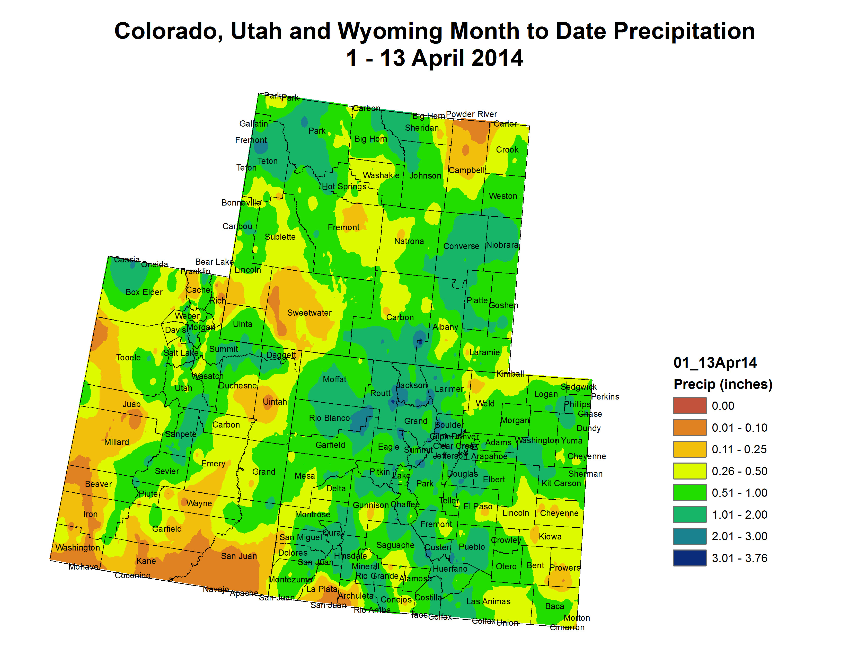
Officials are guardedly optimistic that the 2014 runoff season in Colorado’s high country will be a good one. A potential for flooding does exist, however, if meltdown comes too quickly as a result of sustained hot temperatures during the prime runoff months of May and June.
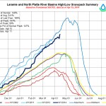
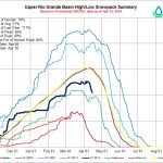
Craig Cotten, division engineer for Div. 3 of the State Engineer’s office in Alamosa, CO, said conditions in the Rio Grande River Basin and Colorado’s San Luis Valley have improved somewhat this year. As of April 1, snowpack was 80 percent of normal. “We’re the lowest basin in the state,” he told The Produce News. “But that’s actually higher than the last two years.”
This is the sixth consecutive year for below-average stream flows in southern Colorado. “Runoff will be closer to normal,” he added. Agricultural producers have been complying with ever-tightening water regulations governing use. According to Cotten, the level of the region’s aquifer continues to drop owing to drought conditions.
Cotten said water quality will likely be affected as a result of ash content from last year’s devastating West Fork Fire. He said the potential for flooding also exists due to the fire.
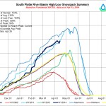
Turning to northern Colorado, Dave Nettles, division engineer for Div. 1 of the State Engineer’s office in Greeley, CO, said, “We’re running well ahead of average snowpack [in the South Platte River Basin].” As of the beginning of April, snowpack was 133 percent of normal. “We have more snow water equivalent than our average peak,” he told The Produce News.
The good news about anticipated runoff could be dampened if the snowpack melts too quickly. Meltoff typically begins in May and peaks in June. Last September, northern Colorado experienced extreme flooding, and the impact of the devastation continues to be felt today. “It depends on temperatures and how the flow moves,” Nettles stated about the coming runoff. “A quick flush, if it happens, could contribute to potential for flooding. But many areas will be fine.”
Another complicating factor, which could contribute to the potential for flooding in the South Platte River Basin, stems from the fact that last year’s flooding was so severe that rivers jumped their banks, creating new flow channels. Debris, Nettles added, may also disrupt flow and create potential for flooding.

From email from Reclamation (Kara Lamb):
We are getting ready to start importing water from the West Slope collection of the Fryingpan-Arkansas system to the East Slope. As long as minimum flows at both the Thomasville and Hunter Creek gages are met, we can begin diversions of additional water through the Boustead Tunnel.
Here are the minimum flows for the Fryingpan River at Thomasville:
Date Min Flow, (cfs)
Oct. 1 – Mar. 31 30
Apr. 1 – Apr. 30 100
May 1 – May 31 150
Jun. 1 – Jun. 30 200
Jul. 1 – Jul. 31 100
Aug. 1 – Aug 31 75
Sep 1 – Sep 30 65Additionally, at Twin Lakes dam, we are curtailing releases to Lake Creek and the Arkansas River today and tomorrow. Today, we scaled back to about 100 cfs. Tomorrow, we will continue scaling back to 0 cfs while a regular review of the dam is conducted. Once the review is complete, we will bring releases back up.
More Fryingpan-Arkansas Project coverage here.
From the Summit Daily News (Alli Langley):
Breckenridge could start construction on a new water plant along the Blue River in as soon as three years. But first, the town wants your input.
The public is invited to attend four forums to learn about the construction of the town’s second water plant and give comments. The forums will be April 23 and 28, at 2 p.m. and 6 p.m. both days, at the Breckenridge Police Station.
“This is the master plan for the next 25 to 30 years,” said town manager Tim Gagen.
At the forums, town officials will explain the projected cost of the plant and upgrades to the water system.
The first phase of the project includes building the plant, pumps and plumbing to get the water integrated with the current system, he said, which should cost about $25 million to $30 million dollars. The plant itself should cost about $10 million, which Gagen called reasonable. The expensive part, he said, will be pumping water a couple miles into town, against gravity.
Phase two includes extending lines into areas outside the town limits not currently serviced, which Gagen said could cost more than $40 million but would only be built if and when people want that service.
Customers living outside the town limits use private wells that have a high likelihood of failure and need equipment replacements after 15 or 20 years. And before this project, he said, if those people wanted water service, the town had to annex their land.
People in those areas have called about extending service to their neighborhoods, Gagen said, not to feed their homes, but to feed water hydrants on the street. That would help with wildfire protection and lower their insurance rates.
“They would have to pay for it,” he said about the phase two extensions. “It wouldn’t be built by the current customers.”
Gagen said he expects questions at the forums about the plant’s locations and the impact on the Blue River.
As far as where the new plant will go, officials know the water will be drawn from the river just north of Swan Mountain Road.
The town hasn’t decided yet on the plant’s exact location, but it will be north of town for several reasons.
Putting it north of town, closer to Dillon Reservoir, means the plant would leave water in the Breckenridge part of the Blue River in town, which he said is better for the health of the river and doesn’t counteract the restoration work done there in the last few decades.
A site north of town also is better for water rights issues, as the Upper Blue Sanitation District has some rights in town.
And the water quantity and quality is better closer to the lake, Gagen said, with lower concentrations of heavy metals leftover from mining.
Gagen said the town looked at putting the plant closer to the original one, south of town, but that wouldn’t solve the problem of insecurity in the system in case of mechanical failure.
Unlike the water systems in Silverthorne and Dillon, which are interconnected in case one of the towns has an emergency, “We’re a standalone system,” Gagen said. “We don’t have a backup.”
“And” he added, “our biggest fear quite honestly is fire.”
Erosion from fire affects the cost to treat water. A second plant would give the utility time for repairs and cleanup.
So although the whole project will cost more because of the location farther north, he said, the town will “trade additional costs for other positives we think will be beneficial to the community in the long-run.”
The Water System Study
A task force established in 2011 to consider issues surrounding the town’s water system found that the supply to the existing Gary Roberts Water Treatment Plant would be very low in an extreme drought, leading to shortages. And though the town has made improvements in water conservation and management efficiency, the current water plant (which was constructed beginning in 1972) is nearing 80 percent capacity.
A study of the town’s water system by Sarah C. Clark, an engineer in Denver, was completed and presented to the town council in January.
The study strongly recommends the construction of a three-MGD (million gallons per day) plant to meet future population demands and provide more service to the homes and lots near the existing water system’s boundaries.
In the event of a wildfire or another environmental disaster or a mechanical malfunction of the current plant, a second water plant would provide a critical back-up system.
The study also noted that the current Breckenridge system supplies high-quality drinking water at a low cost to customers compared to other Colorado communities. The new plant will require increases in the user fees which will be shared by current and future customers.
Besides increasing water rates and fees, Gagen said the town is looking at a list of potential revenue streams, including about $8 million the utility has saved for improvements, grants and funding from partners like the county.
Debt will be the most important element of the financing, he said, helping to spread the cost over about 30 years “so no one generation of people is suffering the cost of paying for the whole thing.”
For now, the town is in the process of gathering public input and meeting with Summit County government and Upper Blue Sanitation District officials.
Then the town will start modifying water rates to fit the new plant, and after three or four years of the design and approval process, it will start construction.
The study is available online at http://www.townofbreckenridge.com, and the town council urges the public to review it before the public forums.
More infrastructure coverage here.

From US News and World Report (Alan Neuhauser):
California’s drought has become the state’s worst on record, draining reservoirs and destroying crops. Yet it’s far from unique. Severely dry conditions are now afflicting about two-thirds of Texas, and droughts also are being felt in parts of Oklahoma, Minnesota and Colorado…
The World Resources Institute, an environmental advocacy group, compared those dry regions with their respective levels of water consumption. Certain drought areas, it found, are still using huge amounts of water, which is putting “high” and “extremely high” levels of stress on their water supplies…
“Drought and water stress overlap in many regions facing water shortages in the United States,” Andrew Maddocks, communications coordinator for the Aqueduct project, wrote on the group’s website.
It’s a trend that poses potentially great dangers to local populations. “Climate change will generally make precipitation more extreme, variable and unpredictable in the years ahead,” Maddocks wrote, citing climate scientists. “Hotter average temperatures mean drier soil, so farms may face greater risks to their crops and ranchers to their herds, even if it rains more regularly.”
From the Glenwood Springs Post Independent (Will Grandbois):
For Gavin Metcalf, April 15 isn’t just tax day. It’s the beginning of six months of full time work as Carbondale’s official “Ditch Rider.”
Metcalf’s steed is a John Deere utility vehicle, but otherwise his job description looks like something out of the previous century. He starts the morning by turning a wheel on a large metal gate along the bank of the Crystal River. When the water in the Carbondale Ditch reaches a certain point, he locks the gate in place.
“You can tell it’s the right depth because that root is just barely sticking out of the water,” he explains. Sure enough, when he walks down to the flume for a more scientific measurement, it’s dead on…
In addition to natural challenges, Metcalf struggles with human interference. People construct makeshift dams which can flood upstream and burn out downstream pumps. They dump all manner of things into ditches they wouldn’t dream of throwing in the river. Not that most of it makes it that far. Even grass clippings tend to stick around and clog the system, explains Metcalf. And when he has to turn off the water to fix the problem, few residents connect the dots.
“The water is there to be used,” Metcalf says, “but a lot of people don’t seem to understand what it takes to make that happen.”
Carbondale’s water rights on the Crystal are as old as the town itself. It’s one of the few municipalities in the region — along with Aspen and Silt — that has kept its system intact. The original 1880s rights were expanded considerably in the 1920s. Since then, usage has fluctuated as the community expands and the ranches begin to disappear.
So far, the runoff forecast for this year looks bright, but Carbondale’s utilities department is planning ahead. “If, at some point, we elect to go into water rationing, we want a really firm idea of what it’s going to take to maintain the system under drought conditions,” explains Utilities Director Mark O’Meara. “It’s going to take some time to really dial in, but I think we have enough foundation to make better judgment calls on how much we take out of the river.”
More Roaring Fork watershed coverage here.

From Circle of Blue (Brett Walton):
Still in the earliest stages of negotiation, two remedies have emerged, both of which seek to fortify Lake Powell, the nation’s second largest reservoir, and preserve its capacity to generate electricity and supply water to the 40 million people who live in the watershed.
One strategy is an operational revision: release more water from upper-basin reservoirs during drought emergencies. The other option would cut demand: ask – or perhaps pay – farmers to stop growing crops in order to save water. Both approaches are technically and legally feasible, according to those involved in the discussions and outside experts.
“We’ve never had to do this before because we never planned for this degree of low water storage,” Don Ostler, executive director of the Upper Colorado River Commission, an administrative body, told Circle of Blue. “We want to plan for extreme hydrology the likes of which we have never seen.”[…]
… in the iconic Colorado River, flows have been above average in only three of the last 14 years. If the rest of the decade follows a similar hydrological trajectory, “dramatic problems emerge rather quickly,” said John McClow, Colorado’s representative to the Upper Colorado River Commission. McClow told Circle of Blue that the basin states used computer simulations last June to replicate the 2001 to 2007 river flows, a rather dry period, from 2014 until the end of the decade…
The upper basin wants to prevent a call on the river, a circumstance in which the four states are unable to meet their legal obligations to send water downstream to Arizona, California, and Nevada. A call has never happened.
The upper basin also wants to keep Lake Powell’s surface elevation from dropping below 3,490 feet, the point at which hydropower generation from Glen Canyon Dam, which forms the reservoir, would probably stop. Lake Powell has never tested that limit, a theoretical threshold. Today, Powell’s surface elevation is 3,574 feet, having fallen 60 feet in two years.
Glen Canyon provides as many as 5.8 million people with a portion of their electricity. Revenue from electricity sales helps pay to operate the dams. It also underwrites measures to reduce salt in the Colorado River and revive fish habitat.
To keep Powell from draining, one option is to release more water from reservoirs located higher in the basin: Flaming Gorge, in Wyoming; Navajo, in New Mexico; and a Colorado cluster known as the Aspinall Unit. These Rocky Mountain reservoirs evaporate less water than Powell, located in Utah’s arid canyon country, said Malcolm Wilson, chief of the Bureau of Reclamation’s water resources group, which operates the reservoirs. But that does not preclude a shift in operations.
“There’s nothing to say we couldn’t release more water than we have to sustain Powell,” Wilson told Circle of Blue, stating that the interests of the upper basin and Reclamation align, both wanting to keep the dam’s cash register ringing…
McClow noted that recreation and environmental constraints would need to be respected. Each of the higher-elevation reservoirs has an endangered species in its watershed, he said.
Along with the reservoir shuffle, upper basin negotiators are debating what a farmland fallowing program would look like. More questions – Who pays for it? Which lands are targeted? – than answers exist now, McClow said.
Doug Kenney, a water policy expert at the University of Colorado’s Natural Resources Law Center, said he saw no obvious legal problems with the two options.
“As long as they don’t try to be too picky about who owns that water, then I think it’s entirely realistic,” Kenney told Circle of Blue. “If they want to be picky, then all sorts of legal issues and potential problems come forward.”
Kenney said that ascribing ownership to the water begins to resemble the selling or transfer of water rights across state lines, a bête noire for the basin. Better, he said, if the water is not earmarked and simply flows downstream.
Ostler, the river commission’s executive director, said that the upper basin would like to have a plan finalized by the end of the year…
…none of the [Lower Basin] representatives that Circle of Blue contacted offered many details about their drought planning.
“We’re certainly having discussions about existing drought and contingency planning for an ongoing sustained drought,” said Colby Pellegrino, who handles Colorado River issues for Southern Nevada Water Authority, the state’s largest water utility. “But we’re not to a point where we can say what those options will be.”
Tanya Trujillo, executive director of the Colorado River Board of California, also demurred and declined to comment.
Pellegrino did say that the lower basin states are using hydrology models used in the Bureau of Reclamation’s Colorado River Basin study, a comprehensive supply and demand assessment published in December 2012.
That study assessed water use through 2060, but the current drought discussions take a narrower view. Pellegrino said the lower basin interests are looking at options through 2026, the year that the shortage sharing agreement expires.