Runoff/snowpack news: Advisory issued for boaters through the Royal Gorge

Clear Creek at Golden gage May 31, 2014 via the USGS

Clear Creek is roaring towards the South Platte River this morning. From email from USGS’s Water Watch:

Streamflow of 1660 cfs exceeds subscriber threshold of 200 at 2014-05-31 04:45:00 MDT
06719505 00060 CLEAR CREEK AT GOLDEN, CO

From The Pueblo Chieftain (Tracy Harmon):

Snowmelt is causing some high water levels in the Arkansas River prompting officials to close one section near Buena Vista and advise against use of the Royal Gorge section just west of Canon City. Colorado Parks and Wildlife and the Arkansas Headwaters Recreation Area closed a small section of the Arkansas River Friday until further notice due to safety concerns from a recently constructed diversion structure and boat chute. Water level in the 2-mile stretch from the Buena Vista Whitewater Park to Johnson Village, is running about 3,100 cubic feet per second.

The Royal Gorge section is running at about 3,700 cubic feet per second, according to the U.S. Geological Survey’s Parkdale gauge.

“The Royal Gorge section is not closed (to boaters) but it is currently under a high-water advisory. With a high-water advisory it is recommended that that section not be run (by commercial rafts) once flows go above 3,200 cubic feet per second,” said Abbie Walls, Division of Parks and Wildlife spokeswoman.

“Our No. 1 priority is public safety,” said Rob White, Arkansas Headwaters manager. “We know this is a popular area of the river, but until we can find a solution, we believe that this area is too dangerous for people to use.”

The good news for whitewater thrill-seekers is that there are plenty of other sections of the river open to rafting access including Browns Canyon just upstream of Salida and the Big Horn Sheep Canyon from Salida to Parkdale. Buena Vista’s Whitewater Park also is still open.

From The Pueblo Chieftain (Ryan Severance):

The Arkansas River in Pueblo is running high and fast but it’s far from creating flood concerns, according to the National Weather Service.

The river is running about 6.27 feet high and at 3,200 cubic feet per second, according to measurement data taken Friday evening at the Pueblo Dam.

“That’s running about 2 feet from even the minor flood stage level,” Larry Walrod, lead forecaster with the NWS Pueblo office, said. “The flow out of Pueblo Dam is controlled so they have the ability to control releases and they still have room for storage in case they need it.”

Walrod said river speeds would have to get up to around 5,500 cubic feet per second before flooding problems would arise.

While river water levels and speed are not at problematic levels for potential flooding, it should be noted that the river is still running higher and faster than usual.

“It’s generally good for the rafting industry but it poses a danger to people in or near the river,” Walrod said. “Water coming down in the flow is cold with temperatures in the 40s and 50s, which is shocking to the system and can take your breath away. Also, with the water running high for the first time since last summer, any debris from the winter gets swept into the current and that’s definitely hazardous.”

From the Glenwood Springs Post Independent (John Stroud):

“The water is big right now,” said Geoff Olson, co-owner at Blue Sky Adventures river outfitters in Glenwood Springs. “The rivers have been flowing about three times the normal rate for this time of year, and we’re expecting a good season all summer long.”

The high water levels mean rafting companies can run stretches of the Roaring Fork River that typically are too low for commercial rafting later in the season, Olson said.

It also means some good, early season whitewater activity along the stretch of the Colorado River from Grizzly Creek in Glenwood Canyon through No Name, which features some class 3 rapids this time of year, he said.

As of Friday afternoon, the Colorado River at Dotsero east of Glenwood Canyon was flowing at just over 15,000 cubic feet per second (cfs) with a gage depth of about 11.5 feet, according to the U.S. Geological Survey streamflow data website, at http://www.waterdata.usgs.gov.

The Colorado River at that location has been rising steadily over the last week, from less than 10,000 cfs and a depth of about 8.5 feet on May 23.

Likewise, the Colorado River below the confluence with the Roaring Fork River in Glenwood Springs was running at 21,200 cfs Friday afternoon, up from around 12,000 cfs at this time last week. The depth in the wider downstream river channel is pushing 10 feet.

The Roaring Fork River itself was running at more than 5,300 cfs just above the confluence in Glenwood Springs on Friday, while the stream depth was pushing 6 feet. That was up from about 2,500 cfs and a depth of 4.5 feet a week ago…

As it stands, the snowpack in the Colorado River Basin is more than 200 percent of normal for this time of year, boosted by late-season storms over the last two weeks, she said.

As of Friday, just 54 percent of the basin snowpack had melted.

“So, we’re only about halfway done,” Hultstrand said. “In a normal year, we usually have about 77 percent of the snowpack melted by this time. It’s definitely melting pretty fast out there now.”

From the Glenwood Springs Post Independent:

Releases from Ruedi Reservoir are spiking to make room for runoff and to help accommodate endangered fish on the Colorado River near Grand Junction.

The U.S. Bureau of Reclamation boosted the releases from the Ruedi Dam by 50 cubic feet per second Friday morning, and it planned another bump of 50 cfs at 8 p.m.

The combined new releases will boost the total releases from the dam to about 370.

“We’ve seen a new forecast come in, and runoff inflows to Ruedi are increasing more than what was forecast back on May 1,” said Reclamation Bureau spokeswoman Kara Lamb. “This is not atypical, especially in years when we continue to add snowpack through the month of May, as has happened this year.”

More storage on the horizon? #COWaterPlan

smithreservoir
From the Valley Courier (Travis Smith):

Colorado’s water history also involves the development of reservoirs. It was quickly recognized by irrigators and municipal users that having the ability to capture and control available water during times of plenty for a reliable water supply during times of shortage was very important.

The Colorado high country provides the best natural reservoir storage in the form of snow pack. The state’s snow pack accumulates during late fall and continues thru early spring, waiting for warm temperatures . As the spring runoff begins, the available water supply to rivers and creeks continues to increase. Approximately 70 percent of the annual water supply runs off during May, June and early July. Irrigators quickly recognized that the water supply from the natural reservoir did not provide a reliable water supply in late summer, which is much needed to finish crops. Flooding and drought also became a concern in the arid west. The worst flood ever experienced in Alamosa took place in 1884, with approximately 20,000 CFS recorded. The Valley also endured a severe drought between 1890 and 1902.

The water development era in the San Luis Valley began in the late 1880’s to early 1990’s. Major canal systems had been developed and began diverting all available water. The Rio Grande was quickly over appropriated by the late 1880’s. The discussion began around approved suitable reservoir sites and the ability to finance a storage project caused much concern with Valley neighbors to the south, New Mexico and Texas. San Luis Valley water users were prevented from developing any further depletion to the Rio Grande by an order from the Secretary of the Interior in 1896. This Federal Embargo meant no reservoir construction in Colorado and was viewed as “arbitrary and unjust” (an excerpt from the valley water attorney George Corlett).

In the meantime, the people of New Mexico and Texas decided to build the Elephant Butte Dam. The Federal Embargo was partially lifted in 1907, which allowed storage projects on the upper Rio Grande. Reservoir sites had been selected and funding services were secured for Rio Grande Reservoir and Santa Maria Reservoir . With the construction of these reservoirs, the irrigators would have a late season water supply to finish crops. These reservoirs were primary used for agriculture, and at times for flood control. The Rio Grande Compact negotiations contemplated additional storage projects that never came to be due to a variety issues. Terrace and Sanchez reservoirs were also constructed around the same time period. Rio Grande Reservoir, also known as the Farmers Union Reservoir, was primarily built for irrigation use, but was used many times for flood control. In 1952, Platoro Reservoir on the Conejos River was completed.

The Colorado Water Conservation Board’s 2004 Statewide Water Initiative identified the need to rehabilitate existing reservoirs, and where possible investigate the opportunity for multi use or multipurpose reservoirs. This concept of multipurpose projects is developing for the San Luis Valley’s reservoirs. By rethinking, retiming and reoperation of the Valley’s reservoirs multiple needs could be met. By timing reservoir releases and storage when possible, wet water is available to the Rio Grande for irrigation, municipal augmentation , stream health, recreation and environmental uses. This multi use idea is built around cooperation and partnership opportunities that meet multiple wet water needs with the same amount of water.

The Rio Grande Cooperative Project is the model of the multi-use project concept. A public/private partnership with the rehabilitation of Beaver Park Reservoir, owned by Colorado Parks and Wildlife, and the Rio Grande Reservoir; the Cooperative Project’s primary objectives are to store and regulate water rights to better meet water demands in the San Luis Valley. The development of the Colorado Water Plan and Basin Water Plan encourage multiuse projects that address the needs of irrigation, municipal, management, augmentation, recreation, and environmental needs. The Colorado Water Plan and the Colorado Water Conservation’s strategic framework recognize the need for multiuse projects, policies and partnerships.

The Rio Grande Basin Water Plan is being developed by members of the Rio Grande Roundtable and other interested citizens. This basin plan supports the continued rehabilitation of the Valley’s reservoirs and encourages the multipurpose objective thru partnerships and cooperation. The Basin Water Plan also recognizes the need for groundwater regulation to manage and sustain the Valley’s aquifers and agriculture economy, as well as the tenet to remain compliant with the Rio Grande Compact. The Valley’s reservoirs offer a bucket in times of plenty and a source of water in times of need. San Luis Valley residents are encouraged to get involved in the water plan by attending the Rio Grande Basin Roundtable monthly meetings held the second Tuesday of each month at the San Luis Valley Water Conservancy District office at 623 Fourth Street in Alamosa. The lead consultant and local liaison from DiNatale Water Consultants is Tom Spezze. Tom can be contacted at tom@dinatalewater.com.

More Colorado Water Plan coverage here.

Runoff/snowpack news: There is little space to store runoff in South Platte River Basin reservoirs

Click on a thumbnail graphic for a gallery of snowpack data from the Natural Resources Conservation Service. The melt-out is in full swing.

From 9News.com (Nick McGurk):

“This is one of the best years we’ve had in the last decade or two,” said Brian Werner with Northern Water.

So good, he said that the state could send out the equivalent of five Horsetooth Reservoirs full of water to Nebraska this year because there’s nowhere to store it in Colorado.

“It’s helping Nebraskans, believe me, but it’s water that we have rights to that we’re not putting to use because there’s nowhere to store it,” said Werner.

It’s why he says Colorado needs more reservoirs. Glade Reservoir has been talked about for a decade. It would take water from the Poudre and store it northwest of Fort Collins.

From the Northern Colorado Business Report (Steve Lynn):

Horsetooth Reservoir and Carter Lake, which comprise Northern Colorado’s share of the Colorado-Big Thompson project, are within about one foot of being full, said Brian Werner, spokesman for the Northern Colorado Water Conservancy District.

Farmers currently are using river water from ditches to irrigate their cropland, but generally use Colorado-Big Thompson project water later in the summer. The project collects water from the Western Slope and delivers it to the Front Range through a 13-mile tunnel the runs beneath Rocky Mountain National Park.

From the Fort Collins Coloradoan (Ryan Maye Handy):

When the Poudre River surged after a rainy Memorial Day weekend and took the lives of two Greeley residents, it alarmed residents across the state. But even after a wet spring and this year’s heavy snowpack, the Poudre is a long way from causing Fort Collins stormwater managers alarm during this runoff season…

It can be hard to pin down what exactly makes the Poudre’s levels fluctuate — it can be the weather, an irrigator, snow melt or another river, like the North Fork, dumping into it.

The Poudre has been running about twice its normal level since the September 2013 floods, when a year’s worth of rain fell in just days across Colorado. But this year a few other things could be fueling the river’s rise. Spring rains at low elevations, for instance, caused the river to rise during Memorial day weekend. In big snowpack years, snowmelt can drastically change the river’s flow.

Much of Northern Colorado’s snowpack in the mountains west of Fort Collins has yet to melt. The force of snow melt-caused runoff all depends on weather — a steady warming trend will prolong the runoff period, where as a rapid rise in heat over an extended period will fill the river quickly.

Peak runoff flows usually hit the Poudre sometime between late May and mid-June…

Fort Collins has several ways of monitoring the river’s power, one of which is using water gauges in Poudre Park, at the canyon mouth, and at the Lincoln Street bridge.

Fort Collins Utilities has a flood warning engineer and other employees who manage a flood warning system around the clock, said Varella. The city has trigger points — threshold measurements for the water — that trigger flood alerts, exactly the same as those used by the National Weather Service to issue flood alerts…

Several things have to fall into place for the river to seriously flood, and the severity of flooding could depend on when those factors come into play.

But as of Thursday, the Poudre’s level’s were forecast to continue to drop, with a possible spike late Friday due to rain. While the river is moving dangerously fast, and is higher than normal, said Varella, all city stream gauges showed only low warning levels.

From the Summit Daily News (Sebastian Foltz):

River accidents are frequently the result of inexperienced boaters getting into unfamiliar situations. This year, with water flows in rivers already climbing toward peak levels because of rapid snowmelt, there’s some concern among those in the rafting and kayaking industry. While it’s safe for professional guiding companies and experienced boaters, those less familiar with how to read rivers and recognize features may struggle in places where they would be fine during other times of the year.

Stretches of water can change dramatically with higher water flows, making ordinarily tame rivers far more challenging.

With flow levels on some rivers currently as much as 10 times higher than what they might be later in the summer, places like the usually tame Upper Colorado River may be far more technical…

The Upper Colorado, for example, now has flow levels approaching 10,000 cubic feet per second (cfs), when much of the season it runs closer to 500-800 cfs.

From The Denver Post (Tom McGhee):

The Cache la Poudre continues to overflow its banks near Greeley and the National Weather Service has extended a flood warning for the area until further notice.

“That river is expected to stay above flood stage until at least June 3,” NWS meteorologist Todd Dankers said Thursday.

A combination of snow melt, triggered by warm weather, and plentiful rain, has sent water flowing into streams and rivers around the area.

A number of streets, trails and open spaces, are closed near the river, including 71st Avenue, 83rd Avenue and 95th Avenue.

Flood advisories, which are issued when rivers and streams run high, but aren’t in immediate danger of flooding, are in place for the Cache la Poudre at the mouth of the Poudre Canyon, and for the South Platte River near Kersey, which is south of Greeley.

The NWS has also issued flood warnings for Jackson and Grand Counties, Danker said. “Snowmelt and these warming temperatures have things right near the top.”

Flooding in Boulder Creek prompted Sheriff Joe Pelle to close the creek to tubing and single chamber belly flotation devices.

The closure will take effect immediately, and will encompass Boulder Creek from Barker Dam east of Nederland to the Weld County line, north of Erie. The closure includes the section of Boulder Creek that flows through the City of Boulder.

A similar ban on tubing is in effect on the Cache la Poudre in Fort Collins until further notice, the Fort Collins police announced.

Afternoon showers are expected through Saturday, and warm nights, in the high country will assure snow continues to melt, Danker said.

“Emergency mangers are keeping an eye on things and we are going to be watching the radar and when things develop we will issue a warning.”

“The urban corridor stands to have the best chance at rain with storms moving off of the nearby mountains,” according to a Colorado Water Conservation Board flood threat bulletin.

With streams and rivers running high, it won’t take much to trigger more flooding, though major floods like those last year aren’t expected, Danker said.

There is a 30 to 40 percent chance of showers Thursday, a 40 to 50 percent chance on Friday, and 30 percent on Saturday. “Showers are coming up from the south. “The showers on Saturday may have a bit more push to them, but it will depend on where they develop,” Danker said.

From Fox21News (Mark Bullion):

About a year ago, Southern Colorado was mostly under an extreme or exceptional drought, which set the stage for the multiple wildfires that happened.

This year, most of the region is out of a drought status with the exception of the southeastern plains, according to the U.S. Drought Monitor.

“They’ve had a few dust storms, a lot of blowing dirt and not a lot of native grasses to hold that soil down,” said Jennifer Stark, NWS Pueblo Meteorologist.

Southern Colorado has for the most part come out of a drought status because of an above average snow pack this past Winter.

But with the above normal snow amounts some areas of Colorado received, there is a concern of runoff into the Arkansas River as temperatures warm and the snow melts.

“That will be the area from Leadville down to the Pueblo Reservoir depending on how the reservoir is filled,” said Larry Walrod, NWS Pueblo Meteorologist. “Also, some of that water will make it east of Pueblo toward La Junta and Lamar.”

Walrod said as of Thursday morning, Fremont Pass still had a snow pack at 147 percent of average.

“The runoff is just starting to peak and it will be in a state of peak here for the possibly two, three or four weeks,” said Walrod.

Stark said the Climate Prediction Center in Washington D.C. is forecasting above normal amounts of rainfall for the next few months, so she is optimistic Southern Colorado will stay out of a drought or where there is an exceptional drought in the eastern plains, the rain will help saturate the soil resulting in the possibility of some areas being changed to a lower drought status.

In addition to Colorado’s water gap we have that pesky old solutions gap, East Slope vs. West Slope

Colorado Water Plan website screen shot November 1, 2013

From the Boulder Weekly (Bob Berwyn):

When Colorado’s earth cracked open in the great drought of 2002, it may have also cracked open a new corner of consciousness about the finite nature of the state’s water supplies. Spurred by the drought, Gov. Bill Owens and Department of Natural Resources chief Russ George created a series of grassroots river-basin-based roundtables around Colorado and started crafting a statewide vision of how the state will allocate river flows in the 21st century.

Ten years later, the process will culminate with completion of a formal state water plan, ordered by Gov. John Hickenlooper — but there will have to be some serious compromise on the “last 10 percent,” says longtime Colorado River advocate Ken Neubecker, an associate director of American Rivers.

But a round of draft documents posted in recent weeks once again raises concern about a host of transmountain water diversion projects that would require huge amounts of energy and disrupt communities and agriculture in the Colorado River Basin.

Some of the projects have been floating around for decades, representing a Rube Goldberg view of the world, where every problem has an over-engineered technical solution: The Big Straw, which would slurp billions of gallons of water from the Colorado River just before it crosses into Utah; the 500-mile Green River pipeline from Wyoming that supposedly would generate hydropower along the way; the Yampa pumpback, the Blue River pumpback and a new Wolcott Reservoir in Eagle County.

“Keeping the idea of these zombie water projects, when there just isn’t any more water to fill those [new] reservoirs doesn’t make sense. … There’s not enough to fill the reservoirs that are here now,” says Save the Colorado campaign coordinator Gary Wockner. The water bosses are missing the big picture by ignoring the fact that Lake Powell and Lake Mead are near or at their lowest levels ever (since filling), Wockner says.

The downstream demand from Arizona, Nevada and especially California throws a huge political monkey wrench into the works that could someday result in a regional showdown, as the Lower Basin cashes in its water chips under the rules of the 1922 Law of the River. Such a so-called Compact Call would require many Colorado water users to curtail their uses.

Developing any new major Colorado River diversions would only worsen the situation, and all of the zombie projects revive visions of the old-school water wars that got Neubecker involved in river conservation back in the 1980s, when Aurora sought to siphon even more of the Eagle River’s flows across the Continental Divide…

The statewide planning push is designed to seek consensus. There’s no question that the basin roundtable configuration has been an improvement over previous tactics, which consisted mainly of “throwing lawyers at each other,” Neubecker says. All in all, the process has been smooth. Each basin — nine, in all — carved out its own vision for Colorado’s water future.

The regional groups have publicly posted “Basin Implementation Plans” for public comment. It’s a key step for the plan, because the final versions should reflect public concerns. In the spirit of the longterm planning initiative, there’s a user-friendly online portal that, for once, doesn’t look like a government website: https://www.colorado.gov/cowaterplan, literally begging for comment.

Now that it’s time to put it all together, cracks are starting to show along traditional fault lines. Some of the big Front Range communities say the plan must include provisions to shunt more water from the Colorado River Basin to the Front Range.

“They’re looking for certainty that there will be another transmountain diversion,” says Colorado River Water Conservation District spokesman Jim Pokrandt. “The Colorado River Basin Roundtable position is, to the degree that there ever could be one, it’s the last tool out of the box.”

Neubecker goes further to say there simply is no water left to divert in the Colorado River Basin…

The pending showdown over the state water plan (a draft is due in about three months, with a fall 2015 deadline for the final version) shows once again the need to connect the dots between water planning, land-use planning and social, economic and cultural values associated with agriculture — not to mention the ecological values of healthy streams and rivers.

Hundreds of Collbran area residents briefed on mudslide dangers — The Denver Post

Grand Mesa mudslide before and after via The Denver Post

From The Denver Post (Nancy Lofholm):

“We are trying to outsmart a mountain,” authorities told a crowd of more than 400 who overflowed the Collbran Community Center on Thursday evening looking for answers about what a massive mudslide hanging over the Plateau Valley will do next.

The slide that roared down from the top of Grand Mesa on Sunday, covering nearly 700 acres and burying three local men, is still unstable, still very difficult to predict and still a challenge for those trying to monitor it. Slide experts are still trying to figure out if they can drop monitors into the top of the mass, dangle someone down from a helicopter or risk the danger of sending geologists onto the slide to place the devices.

“There is the potential for another slide,” Mesa County Sheriff Stan Hilkey told the crowd after acknowledging the three local men presumed dead in the slide.

The large team of experts headed by the Mesa County Sheriff’s Office and the U.S. Forest Service now includes 13 local, state and federal agencies, all working together to try to get a handle on a slide that is unusual in its size and its complexity. Teams are watching for movement from the air, by satellite and from fixed cameras. They are also setting up emergency alert systems for everyone from the 35 property owners below the slide all the way down the valley to where Plateau Creek joins the Colorado River near Interstate 70.

“Gathering data is a big problem,” Hilkey said. “I’ll be the first to tell you we don’t have all the answers for you tonight.”

The U.S. Geological Survey did have better estimates of the size of the pond at the top of the slide and the huge block of earth that is holding it back. The debris block that fell off from the top of the mesa is about 600 feet high and 150 feet thick and spans the nearly ¾-mile width of the slide. Jeff Coe, with the USGS, said he believes there are about 50 million cubic meters in that block, which is holding back a pond now estimated as containing 7 acre-feet of water and being 5 to 7 feet deep. From 15 to 20 cubic feet of water is pouring into that pond each second from the top of the mesa, Coe said, and it is believed to be seeping beneath the slide. That kind of saturated earth is prone to move. He said about 30 million cubic meters of earth have already flowed down the mountain.

The latest seismic information gathered by Colorado Mesa University showed that a first, small slide happened early Sunday morning. The large slide followed at 5:44 p.m. and lasted only a couple of minutes.

Already, sandbagging is going on in Collbran. Plateau Creek has reached its banks — no connection to the landslide — and some of the locals say a third to a half of the snowmelt is still left to come down. Creek banks have already washed out. And rain and warm temperatures forecast for the weekend hold the danger of flooding.

“Collbran is used to water events,” Hilkey said.

Residents filled a box with hundreds of registrations for 911 notifications.

There will be a community service Sunday in Collbran for the three men who lost their lives — Wes Hawkins, Danny Nichols, and his father, Clancy Nichols.

One of Danny Nichols’ brothers drew lengthy applause when he told the crowd that his family would appreciate donations to the University of Wyoming in his brother’s name, so that students from there can come and study the slide, and helpy prevent other deadly slides in the future.

Grand Mesa mudslide before and after photos

Grand Mesa mudslide before and after via The Denver Post

It’s O-fish-al, Federal Dams Ramp up River Flows to Benefit Endangered Fish on the Gunnison River — WRA

Aspinall Unit
Aspinall Unit

From Western Resource Advocates (Bart Miller):

It was a snowy year in the upper Gunnison River basin. With high temperatures this week, snowmelt is accelerating fast. The roar of the river is back. Thanks to a decision by the U.S. Bureau of Reclamation two years ago, river flows now help improve the health of the Gunnison River.

Late last week, spring flows began to ramp up as did releases below reservoirs at the Aspinall Unit, in an attempt to meet target flows that will benefit endangered fish species in the lower Gunnison river. Western Resource Advocates supported the federal decision in 2012 that changed reservoir operations at the Aspinall Unit to increase river flows, and is excited to see the benefits that will result.

”The Bureau of Reclamation is doing a great job under the new reservoir operations plan,” said Bart Miller, Water Program Director at Western Resource Advocates. “This year is a real test of the Bureau’s ability to make good on their commitment to get the river back into balance. So far, they’re passing the test with flying colors.”

The Bureau projects that, on June 2, 2014, flows through Black Canyon will be around 9,000 cubic feet per second (cfs). This will serve key functions like maintaining the river channel in Black Canyon of the Gunnison National Park. In the lower Gunnison River, near its confluence with the Colorado in Grand Junction, flows may reach as high as 14,000 cfs, a target developed by scientists to benefit federally endangered fish.

As WRA posted on a blog last week: “Colorado now has a water-based recreation industry that—on the West Slope alone—is responsible for 80,000 jobs and over $9 billion in revenue each year. We have deeper knowledge of how essential water is for native fish and wildlife species, national parks, and other irreplaceable treasures. We want to continue to provide for resilient and profitable agriculture and communities, but not at the expense of recreation, tourism, and the environment.”

“Improving flows in the Gunnison is emblematic of what should be done in the Colorado Water

Plan and through each river basin’s own water planning: re-assess how we meet the needs of Colorado residents while protecting the environment and a growing river-based recreation economy,” says Drew Beckwith, Water Policy Manager at Western Resource Advocates.

More endangered/threatened species coverage here.

Today is the anniversary of the last concrete pour at Boulder (Hoover) Dam #ColoradoRiver

#COdrought news

Click on a thumbnail graphic for a gallery of drought data from the US Drought Monitor

Click here to go to the website. Here’s an excerpt:

Summary

This US Drought Monitor week was dominated by a weather system that moved across the Rockies, into the Southern Plains and Midwest and through the South and Mid-Atlantic. The system brought damaging wind, hail, and tornadoes. On May 21, a widespread area of Colorado was impacted by an associated supercell thunderstorm which spawned multiple tornadoes and dumped golf ball-sized hail on Colorado Springs. This storm continued eastward dumping much needed precipitation in the Southern Plains through the end of the Drought Monitor week…

The Plains

Locally heavy rain came to the Southern Plains during the Drought Monitor week. Areas from New Mexico and Texas up into western Nebraska benefitted. Texas experienced widespread improvements in Exceptional (D4), Extreme (D3), and Severe (D2) Drought largely throughout the central part of the state and the Panhandle. Moderate Drought (D1) and Abnormal Dryness (D0) also decreased, mainly in the eastern part of the state. Oklahoma likewise experienced an improvement mostly in Exceptional (D4) and Extreme (D3) Drought throughout the center of the state. Conversely, limited improvement in drought conditions in western Nebraska was more than offset by degradation of Extreme (D3), Severe (D2), and Moderate Drought (D1) and Abnormal Dryness (D0) in the central and eastern part of the state…

The West

Little precipitation fell west of the Rockies this week. Conditions remain very dry. Areas of Extreme Drought (D3) expanded slightly in western New Mexico, while precipitation in eastern New Mexico alleviated small areas of Exceptional (D4), Extreme (D3), and Severe (D2) Drought there. Northeast Colorado experienced an improvement in Moderate Drought (D1). Statewide, California, at 75%, and New Mexico, at 72%, lead the nation in percent of pasture and rangeland in Poor or Very Poor conditions. The rest of the West remained unchanged. Wildfires remain a problem in parts of the West. According to the US Forest Service, the current large incidents are all in California, Arizona, and Alaska. So far this year nationwide, there have been 23,339 fires that have burned 710,011 acres which is below the 10-year average (2004 – 2014 average, year to date, is 28,631 fires and 1,139,433 acres according to the National Interagency Fire Center)…

Looking Ahead
During the May 28-June 2, 2014 time period, precipitation is expected across the Northern and Central Plains and into the Southeast. At the same time, below normal temperatures are expected along the Mid-Atlantic Coast and in the states along the western Gulf of Mexico. Above normal temperatures are expected in the center of the country and along the West Coast.

For the ensuing 5 days (June 3-7, 2014), the odds favor normal to above-normal temperatures across the entire contiguous U.S. and southern Alaska, with the exception of the western Gulf of Mexico Coast. Below-normal temperatures are favored in northern Alaska and along the aforementioned area around the Gulf of Mexico. Above-normal precipitation is likely from the Central and Northern Plains, through the Midwest and into the Mid-Atlantic and Southeast. Below-normal precipitation is expected from the Southern Plains through most of the West. Alaska is likely to see above-normal precipitation to the north and below-normal precipitation in the south.

Meanwhile, below is the Seasonal Drought Outlook map from the Climate Prediction Center.

seasonaldroughtthruaugust312014cpc

Runoff/snowpack news: Reclamation plans releases from Flaming Gorge Reservoir for endangered fish #ColoradoRiver

Upper Colorado River Endangered Fish Recovery Program

Here’s the release from the Bureau of Reclamation (Lisa Iams/Heather Patno):

Above average snowpack in the upper Green River Basin will enable Reclamation to increase the overall duration of the planned temporary increase in releases from Flaming Gorge Dam to benefit endangered razorback sucker in the Green River below the dam.
Scientists have detected the presence of larval razorback sucker in critical nursery habitat in the flood plains in the Green River which is the ‘trigger’ for increasing releases from Flaming Gorge Dam. Beginning Monday, June 2, 2014, flows will increase to powerplant capacity 4,600 cubic-feet-per-second for approximately 14 days or until the flows in the Yampa River decrease to between 12,000-13,000 cfs. Bypass releases from the dam will then be initiated to support a total downstream release of 8,600 cfs for another 14 days to maintain the desired total flow in the river of 18,600 cfs at target locations.

Flows from Flaming Gorge Dam have been temporarily increased during the spring since 2011 as part of a multi-year cooperative experimental program to benefit the endangered razorback sucker. Flaming Gorge Reservoir is expected to receive 135 percent of average inflow volume this year supporting a longer increased release period.

Scientists have been monitoring the critical habitat to detect the first emergence of razorback sucker larvae as a ‘trigger’ for an experiment being implemented by Reclamation in cooperation with the U.S. Fish and Wildlife and Upper Colorado River Endangered Fish Recovery Program. A major purpose of the experiment is to transport as many larval fish as possible into critical nursery habitat which exists in the floodplains along the Green River downstream of the confluence of the Green and Yampa rivers. This nursery habitat connects to the river at flows at or above 18,600 cfs, which is the targeted flow this year with the above average hydrology. The increased releases from the dam combined with the Yampa River flows will provide the maximum possible flow to transport the larval fish.

Current projections are for the Yampa River to reach at least 16,400 cfs this Friday, May 30, and for flows to remain elevated between 15,000 to 16,000 cfs through June 5. The projected peak at Jensen, Utah, resulting from the combined flows of the Yampa River and Flaming Gorge releases is approximately 20,000 to 22,000 cfs.

The Utah Division of Wildlife Resources has been consulted concerning the impacts of the releases to the rainbow trout fishery below the dam. While releases during this period will make fishing the river more difficult, no adverse impacts to the fishery are expected.

From The Pueblo Chieftain (Chris Woodka):

Cooler temperatures in May and recent storms have prolonged snowpack in the Rockies, but spring runoff has begun in earnest. Arkansas River levels were consistently above average for the last week, as warmer days and some showers over the weekend contributed to the flows.

“We saw the snow melt and start to run early, but then there was a cooling spell,” said Roy Vaughan, Fryingpan-Arkansas Project manager for the Bureau of Reclamation. “Now, we’re looking at everything running later.”

The Fry-Ark Project already has brought 12,000 acre-feet (3.9 billion gallons) through the Boustead Tunnel into Turquoise Reservoir. It’s expected to bring in a total of 60,000 acre-feet over the next few weeks.

“We’ve reached the peaks at the Boustead Tunnel, and we’re meeting all the minimum flow requirements (for the Fryingpan River),” Vaughan said.

In order to move water across the Continental Divide, stream flows have to be supported on the Western Slope. With the delayed snowmelt, there is about twice as much water as usual tied up in the snowpack for this time of year.

Statewide, snowpack was at 189 percent of median Tuesday, with the South Platte at 265 percent. Snow is heavier in the northern part of the state, while lagging in the south.

For the Arkansas River basin, that works out to 131 percent of median, but only because snowpack is so heavy near the headwaters of the Arkansas River.

In the Rio Grande basin, snowpack is at 32 percent.

It was never great this year, and now mostly has melted.

Flows in the Upper Arkansas River increased by 2 feet in the last week, with flows at 2,500 cubic feet per second as of Tuesday — significantly higher than normal for the end of May.

Fountain Creek has been up and down, increasing by a foot or more at times as storms hit El Paso County. Locally, heavy rains of up to 2 inches fell in the area from Friday to Sunday.

The Arkansas River at Avondale also climbed a foot over the weekend, and was flowing at about 2,800 cfs Tuesday.

From the Fort Collins Coloradoan (Ryan Maye Handy):

The swollen Poudre River this week surpassed peak runoff levels for the past three years, even though high snowmelt season has yet to hit Northern Colorado…

The deep snowpack in Northern Colorado’s mountains has yet to melt away, meaning the runoff season and higher river levels are still yet to come. The forecast for Fort Collins this week is for summer-like temperatures, which could jump-start the runoff.

“It’s all going to be really driven by the temperatures this week,” said Wendy Ryan, the assistant state climatologist. “With that much water still in the high country, it’s definitely not time to forget about snowmelt. At least, not yet.”

Still, U.S. Geological Survey data indicates the river has a long way to go before it reaches September 2013 flood levels.

The river has been running higher than normal since the September floods, and high snowpack levels and recent rains have further elevated the flow. At its highest point on Monday, the river measured at 7.2 feet, just barely below the flood stage at 7.5.

The river reached its peak flow around 5:30 p.m. on Monday, when it measured 4,900 cubic feet per second, of cfs, at the mouth of the Poudre Canyon. One cubic foot per second is equal to one basketball floating down the river every second. The flows have been lowering since Monday, and the peak was well past by Tuesday afternoon.

The river measured 10,000 cfs at its peak during the September floods…

The full-fledged runoff season has yet to really get started along the Poudre, but this week could be one of the first of consistently higher temperatures that melt snowpack.

There has been little runoff from the mountains west of Fort Collins to date, said Ryan. The Natural Resources Conservation Service measures snowpack throughout the winter in Colorado and takes snow water equivalent measurements, showing how much water is in the snow.

At a Joe Wright reservoir measuring point, NRCS measured a peak of 32 inches of the snow water equivalent. Only two inches of that has run off.

Rain has created runoff from the lower elevations, specifically over the High Park Fire and Hewlett Fire burn scars along the Poudre Canyon.

This week, temperatures in the 70s and 80s are expected to cause snowmelt, but the National Weather Service is not predicting serious floods along the river. The river is forecast to slowly rise throughout the week.

From The Denver Post (Monte Whaley):

One of 411 state highway bridges bruised by September flooding got a once over Wednesday by a small group of state inspectors who aim to pinpoint structural problems before a big spring runoff.

A swollen Little Thompson River caused some erosion under the bridge, which spans southbound Interstate 25 just south of Johnstown. But it’s not known yet how much bolstering the bridge needs, said Joshua Laipply, state bridge engineer for the Colorado Department of Transportation.

“We’ll review the data and make some decisions depending on what we see,” said Laipply, who quickly pointed out the bridge currently doesn’t pose any danger to motorists. “Bridges like this one, have foundations all the way to bedrock. “It’s perfectly stable now.

“But, if we had another 500-year storm now, then I’d be worried.”

At least four teams from CDOT, as well as bridge consultants hired by by the agency, are examining the 411 bridges through June. They hope to discover and fix any safety and structural woes before high temperatures prompt mountain runoff, CDOT spokesman Bob Wilson said.

Most of the bridges are in the Denver-metro area and got tagged with minor damage during the flood. They were inspected shortly after the flood waters receded and deemed drivable with the idea they would get more attention this spring, Laipply said.

In all, about 1,000 bridges from Colorado Springs to Sterling were damaged in some way by the flooding with the most severe getting immediate work, Laipply said.

Bridges in Colorado are inspected every two years, but the flooding meant that schedule had to be moved up.

“These are what we call ‘event inspections,’ ” Laipply said. “So far, what we’ve seen has not been a surprise to us.”

Many of the bridges have seen plenty of “scour” — water flow that takes soil from a bridge’s foundation and moves it downstream. Crews will likely apply rock to make bridge foundations stronger. The crews will have to take into account the changes in river flow and channel elevation caused by the surging water, Laipply said.

CDOT design engineers Scott Huson and Tom Moss each took measurements of the Little Thompson as morning traffic zoomed over their heads. At one point, the river was chest-high to Moss.

“It can get interesting for us out there in the water,” Huson said, “but it’s a job has to be done.”

From The Greeley Tribune (Eric Brown):

The Poudre River height near Greeley reached nearly 9 feet Tuesday afternoon, topping its flood stage of 8 feet, according to the National Weather Service.

The National Weather Service forecasts were calling for the river to peak at 9 feet that afternoon or in the evening, then gradually fall to below the 8-foot flood stage by early Thursday morning and stay there through the end of the week.

“We anticipate seeing it crest pretty soon, for now,” Eric Reckentine, city of Greeley deputy director of water resources, said Tuesday afternoon. “But we don’t expect this to be the last time we see high water during this run-off season. We’ll keep monitoring it.”

In addition to having high water levels, the Poudre River near Greeley was also moving fast on Tuesday.

Flows at the Greeley gauge at 3:30 p.m. were at about 3,100 cubic feet per second. The historic average is at that measuring point is about 300 cfs.

From KREX (Jacklyn Thrapp):

Recent warm weather melting mountain snowpack prompts dangerous water levels on the Colorado River. According to the National Weather Service, the current flow of the Colorado River is dangerous, quick, cold and strong. The river in Grand Junction is close to bankfull, meaning it’s close to overflowing.

By this weekend, there’s a chance local water levels will be above bankfull, which may cause floods.

Collbran: Residents below Grand Mesa mudslide are leaving ahead of possible additional problems

Grand Mesa mudslide May 2014 via The Denver Post

From The Denver Post (Nancy Lofholm):

Residents along Salt Creek Road were loading up horses Wednesday, lining up a moving truck for a 127-year-old grand piano, boxing up baby pictures and reassuring anxious relatives by phone that they were keeping a close eye on the huge landslide on the mountain above them. About 35 of them were warned by the Mesa County Sheriff’s Office on Tuesday night that they should be prepared to leave at any time. A lake of trapped water is building up behind a huge earthen slab at the top of the slide and could send another torrent of mud down Salt Creek and into this neighborhood of ranches.

The unusually massive slide, which is three miles long and half-mile wide, first let go Sunday afternoon. It roared down a north face of Grand Mesa at an estimated 170 miles per hour, moving like cement down a concrete-truck chute, burying three local men and now threatening to inflict more damage.

The county has declared a state of emergency for the area, and Gov. John Hickenlooper’s office has promised help. Federal and state government slide experts are on the ground and in the air studying and monitoring the unstable mass in hopes they can issue a timely warning if it begins to move again.

Some who live along Salt Creek Road and have Salt Creek running at capacity in their backyards aren’t waiting any longer for that warning. They are getting out now.

“We rode up to the slide area on horseback, and I seen what I need to see,” said Shelby Ehart, who was packing up his wife, Jennifer, and their four children and the Salt Creek Ranch livestock and heading for a friend’s house in nearby Molina. Ehart said he grew up hunting in the area of the slide and was shocked when he found ravines he knows were 800- to 900-feet deep now brim full of mud and debris.

“We don’t want to overreact,” said Jennifer Ehart as her husband loaded horses, “but we also don’t want to take chances.”

Across Salt Creek Road, Shannon Murphy cradled her 10-day-old baby and said she has put together a plan to get out if need be. But she is waiting for word from experts before she gets out.

“We’re just paying attention to the people who know the land, know the water and know the topography,” she said.

One of those is her father, Tom “Pudge” Cox, who was a state water commissioner for 27 years. If he decides it’s time to get out, Murphy said she will. Her next-door neighbor Celia Eklund also has been consulting with her son, James. He is director of the Colorado Water Conservation Board. She and her husband have plans to go to Arvada and stay with a daughter if the experts say go.

Authorities have handed out fliers advising residents to have evacuation plans while the experts puzzle over a slide that is unusual in its size and in its formation of what is essentially a poorly dammed lake at the top.

The search for the three local men presumed buried — Wes Hawkins, 46, Danny Nichols, 24, and his father, Clancy Nichols, 51 — remains suspended because of the unstable area.

Geologists, hydrologists and engineers have been working with local experts such as Pudge Cox to try to get a better handle on how the slide might behave from here on out. A big unknown affecting that is how deep the lake is at the top. They are using sheriff’s office drones that have the capability to survey the slide to see if it is moving and the lake to see how deep it is. The team of experts was joined Wednesday by U.S. Geological Survey geologists who had worked on the slide that killed 41 people in an Oso, Wash., subdivision in March.

Collbran interim manager Davis Farrar said town officials are meeting with the experts and the sheriff’s office nightly to assess the dangers and to plan for worst-case scenarios. The experts have said that it is possible another slide could bring mud and debris all the way into Collbran if it hits Plateau Creek where it intersects with Salt Creek and builds up debris at a bridge in the middle of this town of less than 400. Farrar plans to call a community meeting Thursday night so that residents can get the latest information and know, as close as anyone can tell, what the true threat is.

Kaden Ehart, the 14-year-old son of Shelby and Jennifer Ehart, said he doesn’t need experts to tell him.

“It has to come down here,” he said of the lake filling above their home. “There ain’t no other place for it to go.”

Rodney Hewitt’s home is the closest to the slide. It stopped about 300 yards from his house as he watched television inside and thought he was just hearing thunder. The slide also registered as a magnitude 2.8 earthquake, according to the USGS. But Hewitt isn’t leaving yet. He said he will know it is time to go “when I look up and see trees falling. Then I’ll fire up the pickup and get the hell out of Dodge.”

Those who stay for now won’t be resting easy. Celia Eklund said she no longer feels safe in the home she grew up in and that has always been her “place of comfort and safety throughout my life.”

“Come on mountain,” she said as she stood in her front yard shaking a fist toward the slide area and fighting back tears. “Stay where you’re at.”

Proposed clarification for what constitutes “Waters of the US” worry some in agriculture

Sheep Herders on the Uncompahgre Plateau back in the day

From the Glenwood Springs Post Independent (John Stroud):

New rules meant to clarify the types of waterways protected under the federal Clean Water Act and create more certainty for agricultural water users could leave things as ambiguous as ever, area ranchers told a leading EPA official here Wednesday.

“I think this just muddies the waters, and does not make it more clear,” Carbondale-area rancher Bill McKee said during a presentation by EPA water programs officials, including Nancy Stoner, the agency’s acting assistant administrator. Stoner is helping to oversee a rewrite of rules governing protected waters under the landmark 1972 law aimed at cleaning up the nation’s rivers, lakes and streams…

Irrigation systems typically found in the Rocky Mountains, where water is shared by multiple ranchers and other users to irrigate fields, and even golf courses and lawns, via ditches that eventually return water to the river system, seem to qualify as protected waters by the revised definitions under review by the EPA and the Army Corps of Engineers, they said.

But Stoner said the new rules are intended to preserve existing agricultural exemptions, and even make it easier for ranchers to carry out certain types of conservation practices such as building stream crossings for livestock or making wetland or riparian enhancements without a permit.

“The goal is to make it as clear as we can which waters are protected, and to make it easy to figure out if you are complying,” she said during the meeting, held at the El Jebel firehouse.

Stoner was invited by the nonprofit Roaring Fork Conservancy to speak on the proposed rule changes with ranchers and other area water users and government officials…

The 90-day public comment period on the proposed new rules remains open until July 21. Details about the rule changes and instructions on submitting comments can be found at http://www.epa.gov/uswaters…

The new rules do not expand the types of water protected under the Clean Water Act, explained McCarthy, but further clarify what qualifies as “navigable waters of the U.S.” under the law, she said.

That primarily applies to protecting headwaters, wetlands, major waterways and their tributaries, as long as they have an established streambed, bank and “ordinary high water mark.”

Some ditches are regulated if the source point and discharge are on a regulated stream, McCarthy said. But the agricultural exemptions for routine operations remain.

“The comments we are seeking are really important, and we want a Western perspective to make sure these definitions make sense for the types of resources we see here,” she said.

The proposed new rules also expand exemptions to 50 types of agricultural conservation practices involving waters without having to notify the Army Corps or obtain permitting.

“Farmers and producers will not need a determination of whether the activities are in ‘waters of the United States’ to qualify for this exemption, nor will they need site-specific pre-approval from either the Corps or the EPA before implementing the practices,” according to an information sheet distributed by Stoner at the meeting.

The proposed rule also does not regulate ground water, tile drainage systems or expand regulation over ditches, Stoner also explained.

More EPA coverage here.

Weekly Climate, Water and Drought Assessment of the Upper #ColoradoRiver Basin

wyutcoprecipitationmonthtodate0501to05212014

Click here for the current assessment. Click here to go to the NIDIS website hosted by the Colorado Climate Center.

2014 Colorado November election: Colorado Water Congress — Initiative 75

Flooding likely off the Waldo Canyon burn scar #COflood

Waldo Canyon Fire
Waldo Canyon Fire

From The Pueblo Chieftain (Chris Woodka):

El Paso County can’t do everything it would like to do to prevent flooding from the 2012 Waldo Canyon burn scar. There isn’t enough money.

Rain that is likely to fall on the 18,000-acre burn scar west of Colorado Springs this year will again cause disproportionate flooding because of the lack of vegetation. But the county, in cooperation with the Coalition for the Upper South Platte, Colorado Springs, the Forest Service, Manitou Springs and other agencies has taken some steps to decrease the damage from flooding.

“There is always more that can be done,” John Chavez, stormwater coordinator for El Paso County told the Fountain Creek Watershed Flood Control and Greenway District Friday.

About $40 million has been spent in fire recovery so far, but there are challenges ahead.

One of those is Williams Canyon above the Cave of the Winds. The canyon just east of Waldo Canyon, where the fire started, is so steep that remediation efforts would be too costly and any water retention could flood caves in the area.

“It’s Swiss cheese,” Chavez said.

Colorado Springs, which began some of its fire remediation projects last year, found they were overwhelmed by the runoff from rains in September.

On top of that, large masses of sediment are still perched on rocky slopes north of U.S. 24 and Upper Fountain Creek.

“The sandy bed hasn’t moved yet,” said Mark Shea, who is coordinating fire remediation for Colorado Springs Utilities. “When it does, that’s going to change the game.”

More Fountain Creek coverage here.

USDA: Colorado River Basin designated Critical Conservation Area #ColoradoRiver

Colorado River Basin including out of basin demands -- Graphic/USBR
Colorado River Basin including out of basin demands — Graphic/USBR

Here’s the release from the USDA:

Agriculture Secretary Tom Vilsack today joined Senate Agriculture Committee Chairwoman Debbie Stabenow to launch a new era in American conservation efforts with an historic focus on public-private partnership. Vilsack made the announcement in Bay City, Mich., which sits at the heart of the Saginaw Bay watershed in the center of the Great Lakes region, an area where agriculture is a leading industry.

Vilsack also praised Senator Stabenow for her leadership as Agriculture Committee Chair to improve conservation programs in Michigan and across the nation, and acknowledged her work to craft and secure passage of the 2014 Farm Bill, which authorized USDA to create the new conservation program.

“This is an entirely new approach to conservation,” said Vilsack. “We’re giving private companies, local communities, and other non-government partners a way to invest in what are essentially clean water start-up operations. By establishing new public-private partnerships, we can have an impact that’s well beyond what the Federal government could accomplish on its own. These efforts keep our land resilient and water clean, and promote tremendous economic growth in agriculture, construction, tourism and outdoor recreation, and other industries.”

Along the Saginaw Bay, intensive agricultural production, industrial pollution and other factors have created a need for enhanced water quality efforts. The new conservation program announced today, called the Regional Conservation Partnership Program (RCPP), will benefit similar areas across the nation. RCPP streamlines conservation efforts by combining four programs (the Agricultural Water Enhancement Program, Cooperative Conservation Partnership Initiative, the Chesapeake Bay Watershed Initiative, and the Great Lakes Basin Program for Soil Erosion) into one.

The RCPP will competitively award funds to conservation projects designed by local partners specifically for their region. Eligible partners include private companies, universities, non-profit organizations, local and tribal governments and others joining with agricultural and conservation organizations and producers to invest money, manpower and materials to their proposed initiatives. With participating partners investing along with the Department, USDA’s $1.2 billion in funding over the life of the five-year program can leverage an additional $1.2 billion from partners for a total of $2.4 billion for conservation. $400 million in USDA funding is available in the first year. Through RCPP, partners propose conservation projects to improve soil health, water quality and water use efficiency, wildlife habitat, and other related natural resources on private lands.

This is an example of government at its best—streamlining multiple programs into one more effective effort, providing flexible tools, and connecting local citizens and organizations with resources that best address their priorities, protect and improve their quality of life, and propel economic growth.

In addition to supporting local conservation goals, clean land and water investments create jobs in local communities. Conservation work involves building and maintaining infrastructure—building terraces in fields or restoring wetlands, which requires the hiring of contractors, engineers, scientists, and others. A 2013 study commissioned by the National Fish and Wildlife Foundation estimates that last year, conservation activities supported more than 660,000 jobs.

Conservation also provides an economic boost by spurring local tourism. Cleaner water and enhanced wildlife habitat provide additional opportunities for hunting, fishing, and outdoor recreation. The outdoor recreation economy supports 6.1 million direct jobs, $80 billion in federal, state, and local tax revenue, and $646 billion in spending each year.

The RCPP has three funding pools:
35 percent of total program funding directed to critical conservation areas, chosen by the agriculture secretary;
40 percent directed to regional or multi-state projects through a national competitive process; and
25 percent directed to state-level projects through a competitive process established by NRCS state leaders.

The critical conservation areas Secretary Vilsack announced today are: the Great Lakes Region, Chesapeake Bay Watershed, Mississippi River Basin, Longleaf Pine Range, Columbia River Basin, California Bay Delta, Prairie Grasslands, and the Colorado River Basin [ed. emphasis mine].

USDA is now accepting proposals for this program. Pre-proposals are due July 14, and full proposals are due September 26. For more information on applying, visit the announcement for program funding.

To learn about technical and financial assistance available through conservation programs, visit http://www.nrcs.usda.gov/GetStarted or local USDA service center. For more on the 2014 Farm Bill, visit http://www.nrcs.usda.gov/FarmBill.

From The Durango Herald (Mary Bowerman):

The Colorado River basin is being listed as a critical conservation area under a new multi-billion dollar program that will fund conservation and soil-protection efforts, U.S. Secretary of Agriculture, Tom Vilsack announced Tuesday.

The new measure, called the Regional Conservation Partnership Program, facilitates public-private partnerships – a structure in which nonprofits, universities and local and tribal governments, among others, can apply for grant money to work with producers like the agricultural sector in implementing innovative environmental protection plans.

The Department of Agriculture will invest $1.2 billion over the five-year length of the farm bill, while participants will match those funds. With an expected $400 million in funding available during the first year, 35 percent of the total funding will go to eight critical areas, including the Colorado River basin, that covers parts of seven “basin” states and provides water for 30 million people.

That means the Animas River, a tributary of the San Juan River and part of the Colorado River basin, could see funding under the designation efforts.

“We have more and more pressure on the water supply,” said Bruce Whitehead, executive director of the Southwestern Water Conservation District in Durango. “We’re hoping this will provide incentives for people to implement some conservation practices that will help meet the demands on Colorado River basin.”

With Colorado’s growing population coupled with drought, the river basin has been strapped to meet agricultural and recreational demands.

In early May, Sens. Michael Bennet and Mark Udall, and Rep. Scott Tipton pushed for the river basin to be designated a critical conservation area.

Here’s a release “Tipton, Bennet, Udall Welcome USDA’s Conservation Designation for Colorado River Basin” from US Representative Scott Tipton’s office:

U.S. Senators Michael Bennet and Mark Udall and U.S. Representative Scott Tipton today welcomed Agriculture Secretary Tom Vilsack’s announcement that the Colorado River Basin is being designated a Critical Conservation Area (CCA) under the Regional Conservation Partnership Program (RCPP).

The announcement follows a request from the lawmakers to make the designation in order to complete critical conservation projects throughout the river basin. Bennet also pressed Secretary Vilsack on the designation at a Senate Agriculture hearing earlier this month.

“The Critical Conservation Area designation for the Colorado River basin will provide resources requested by a broad coalition of regional stakeholders to help manage historic drought conditions and better ensure sustained agriculture production and economic health in the headwaters region,” said Tipton.

“Colorado is the headwaters state and the Colorado River is a precious source of water for not only our state, but also 19 other states downstream,” Bennet said. “With persistent drought conditions and a growing population across the West, the demands on the river are greater than ever. This designation is crucial to moving forward with projects that will help sustain the river for all of its uses into the future.”

“The Colorado River — from its headwaters in the Rocky Mountains through to the Pacific Ocean — sustains Colorado and the West. Despite this past winter’s snowfall, the river and every community and industry it touches is at risk due to rising temperatures and persistent drought,” Udall said. “Designating the Colorado River basin as a Critical Conservation Area through provisions in the 2014 Farm Bill, which I strongly supported, will help preserve this iconic waterway — and bolster local efforts to safeguard our water.”

The designation will provide producers in the Colorado River basin with necessary resources and funding to implement conservation projects and increase the sustainability of regional water, soil, wildlife, and related natural resources. In the face of hotter, drier conditions and the state’s growing population, it is becoming increasingly challenging for the river basin to meet agricultural, recreational, and municipal demands.

The designation has the support of the Colorado River District, Mesa County Commissioners, Dolores Water Conservancy District, Denver Water, the Colorado Water Conservation Board, the Southwest Water Conservation District, and other groups around the state.

The RCPP was created under the new conservation title of the 2014 Farm Bill, which Bennet and Tipton helped craft as respective members of the Senate and House Agriculture Committees. Bennet was also a member of the conference committee convened to work out the differences between the Senate and House versions of the Farm Bill, and he is the Chairman of the Agriculture Subcommittee on Conservation, which has jurisdiction over the RCPP Program.

From the Deseret News (Amy Joi O’Donoghue):

Authorized with the passage of the farm bill of 2014 in February, the Regional Conservation Partnership Program directs money to boost soil health and bolster water quality in a program that now brings together businesses, nonprofits and government agencies.

In Utah, money could go toward improving riparian habitat along the Jordan River, improving rangelands as a fire suppression management tool, or addressing the aftermath of wildfire destroying a watershed, such as the 2012 Seeley Fire that impacted Emery County’s Huntington Creek…

Vilsack said conservation initiatives go beyond helping the land, the water and wildlife but ultimately put “boots on the ground,” by providing jobs. He noted a 2013 study by the National Fish and Wildlife Foundation that said conservation projects supported more than 600,000 jobs.

Sean McMahon with The Nature Conservancy joined Vilsack on the conference call and stressed that the new program allows projects to expand from field and farm to a watershed and landscape level.

“This truly is a historic day for conservation,” he said. “It really will usher in new era in terms of public/private partnerships.”

The new program was also hailed by a conservation coalition of sportsmen.

“One of the outstanding fruits of the 2014 Farm Bill is being harvested today,” said Whit Fosburgh of the Theodore Roosevelt Conservation Partnership.

“The RCPP program, combined with the Conservation Reserve Program, will produce huge benefits throughout the agricultural landscape. It is a chance for sportsmen to step up and engage effectively in the new Farm Bill – and in conservation efforts that will directly benefit important fish and wildlife habitat.”

More Colorado River Basin coverage here.

Colorado Foundation for Water Education: Water Educator Network Orientation webinar tomorrow 5/29 at 12

Runoff/snowpack news: Wyoming bracing for flooding along the Laramie River

Click on a thumbnail graphic for a gallery of snowpack data from the Natural Resources Conservation Service.

From the Laramie Boomerang (Chilton Tippin):

The Laramie River reached 6.3 feet Tuesday in Laramie, entering “moderate-flood” stage. With warming temperatures and rain in the forecast, it could reach 6.7 feet by June 1, according to the National Weather Service. The “major-flooding” threshold is 7 feet.

Nearly 200 volunteers checked in at Woods Landing and Big Laramie Valley Volunteer Fire Department stations Tuesday to pile thousands of sandbags near the rising river…

The Snowy and Sierra Madre ranges got between 3 and 4 feet of snow on Mother’s Day, followed by temperatures warming to above 70 degrees and rainstorms over the weekend, Binning said.

From The Denver Post (Scott Willoughby):

Even in land-locked Colorado, Memorial Day served as a day at the beach for folks across the state.

High water in rivers statewide brought out the adventurous and encouraged others to take a more cautious approach and enjoy the views from dry land as the potential hazards of swift and surging currents began to reveal themselves at the start of what is expected to be a banner year for snowmelt runoff.

“It’s a blessing in that our overall season ends up being really, really good,” said Antony McCoy, head boatman and operations manager for Vail-based Timberline Tours whitewater rafting company. “But during the early season in a year like this, we often have to reroute and run trips differently than normal in the name of safety. Out decisions are always based on safety first and fun second, and we make those decisions day by day.”

With warm temperatures and weekend precipitation boosting flows, Timberline Tours and other established commercial rafting companies were forced to make reroute Memorial Day trips away from the raucous Dowd Chute section of the Eagle River between Minturn and EagleVail. The company institutes a cutoff for commercial trips through the Class IV-plus run when the river broaches 4½ feet on the gauge installed atop Dowd Chute, launching just below the most severe whitewater rapids instead.

“That’s a fun level for expert kayakers, but it gets tricky in a raft,” McCoy said. “And with water this high, most clients don’t really notice the difference. They still love it.”

Ironically, it’s just about the time that many commercial rafting companies begin to take more extreme precautions when many of the most daring decide that conditions are optimal.

A few miles below the Eagle River’s confluence with the Colorado River, the state’s growing cadre of river surfers arrived en masse at the increasingly renowned Glenwood Springs Whitewater Park on Monday. There they were greeted by river flows unseen on the Colorado since the high-water year of 2011, measuring in the neighborhood of 16,000 cubic feet per second below the confluence with the Roaring Fork River.

“I drive up here from Boulder just about every weekend this time of year,” said Ben Smith, a stand-up paddle (SUP) surfer of two years who had never ridden the river at flows above 5,000 cfs before this spring. “This season, I’m going to surf it as much as I can, and every weekend is like a new experience for me. It’s a different wave each time. Better and better.”

Surfers on Monday’s unofficial launch of summer were lined up as many as 10 deep on both sides of the Colorado River at West Glenwood, some with paddles and others with traditional surfboards diving headlong into the raging currents before popping to their feet for rides lasting several minutes. They alternated with — and largely outnumbered — skilled whitewater kayakers performing tricks in the frothy whitewater as spectators on the banks took in the show. One photographer launched a drone above the surfers to capture the action on video.

“This wave is by far my favorite,” Smith added. “A lot of kayak play holes have a big foam pile that’s designed to hold the kayaks in the play spot, whereas this wave is so steep that it’s gravity that’s pulling you down the face of it, which is what an ocean wave does. Plus it’s so clean. You can make these nice big turns on a clean, green wave. It’s the closest thing to ocean surfing I think that you are going to get in Colorado.”

In a state renowned for its paddlesports offerings and participation, it comes as no surprise that Smith and several others have adapted a paddle to the surfing equation. Credit for SUP’s origin goes back to Honolulu, where it was known as “beach boy” surfing by the Hawaiians who used paddles while standing to photograph tourists taking surfing lessons more than 50 years ago. The sport’s recent resurgence on the ocean has rapidly crept inland during the past decade, where it has established a home on and around the beaches of Colorado.

From the Colorado Daily (Sarah Kuta):

The heavy rains and scattered thunderstorms in Boulder County over the weekend gave emergency officials a taste of what may be coming during flash flood season this summer. With the ground still heavily saturated from September’s floods, the rain that fell off and on for multiple days last week pooled in underpasses, streets and drainage areas, and it gave residents of the area burned in the Fourmile Fire of 2010 a short-lived scare. Ultimately, emergency officials said the storms didn’t cause any significant destruction and allowed them to test their plans ahead of what’s sure to be another busy flash flood season in Colorado…

Flash flood season officially began April 1 and ends Sept. 1, though it’s not just local rains and thunderstorms that can cause flooding, Chard said.

Thunderstorms high up in the mountains can cause the snow to melt quickly, prompting spring runoff to accelerate and fill the creeks within the county. Chard added that extra runoff may also occur because the ground is still saturated with water from September’s floods. The water table can stay elevated for a year to 18 months after such a major rain event, Chard said.

All of those factors have led emergency officials to ask residents to be extra vigilant this flash flood season.

“Make sure you’re signed up for emergency warnings, have a plan, have a weather radio,” Chard said. “Pay attention to the skies; pay attention to the forecast.”

From Steamboat Today (Tom Ross):

With 20 inches of water still stacked up in the snow on Rabbit Ears Pass and forecasts of daily high temperatures pushing into the low 80s Wednesday before tapering off to the mid-70s later in the week, the Yampa River in Steamboat Springs has a chance to reach the bank-full stage at the Fifth Street Bridge June 4 to 5. But the current outlook does not foresee it exceeding flood stage of 7.5 feet in the next 11 days.

The Yampa was flowing harmlessly over its banks and bypassing its meanders in the vicinity of Rotary Park as of late Sunday afternoon.

The Elk River at its confluence with the Yampa west of Steamboat is another story. The Colorado Basin River Forecast Center in Salt Lake City, Utah, updated its projected streamflows for the Elk Tuesday morning and reported that the river shot beyond bank-full over the holiday weekend and could nudge flood stage overnight Wednesday and Thursday before dipping just under flood stage again during the daylight hours. A tentative forecast for the Elk, which is weather dependent, anticipates the river will go higher June 1 to 3 but continue to bounce above and below flood stage during its diurnal cycle, which sees peak flows at night…The Elk was flowing at 4,090 cubic feet per second at 4 p.m. Tuesday, and to put that in perspective, it peaked at 6,860 cfs on June 6, 2011. The Yampa, which was flowing at 3,360 cfs Tuesday afternoon, peaked at 5,200 on June 7, 2011.

The snowpack on Rabbit Ears is 175 percent of the median for the date, and some of that snowmelt will inevitably flow down Walton Creek, which passes through the city’s southern suburbs near Whistler Park before running beneath U.S. Highway 40 and quickly into the Yampa.

Soda Creek is another tributary of the Yampa that can create minor flooding in Old Town Steamboat. #City of Steamboat Springs Public Works Department Streets and Fleet Superintendent Ron Berig said Tuesday the creeks become a problem when the Yampa gets so high it backs up its tributaries.

From the Sky-Hi Daily News (Hank Shell):

With rivers already running high and temperatures expected to rise, the National Weather Service has extended a small-stream flood advisory for Grand County until 9:30 p.m. on Thursday, May 29. Nowell Curran with Grand County’s Office of Emergency Management said her office gave the go ahead to extend the advisory due to a possible increase of runoff into the already swollen Upper Colorado River and its tributaries…

Snowpack in the Upper Colorado River Basin was over 140 percent of its normal level in April, according to a Natural Resources Conservation Service snow survey. Officials said earlier this year that they were preparing for a run-off season comparable to 2011, but Curran said that the worst case scenario could now surpass the destructive flooding Grand County saw that year.

From KUNC (Jackie Fortier):

Northern Colorado’s water storage is nearing capacity headed into the peak season for farm and residential users due to mountain snow melt and rains. Horsetooth Reservoir and Carter Lake are already full.

“We haven’t been this full for a couple years at the two reservoirs,” said Brian Werner, spokesman for Northern Colorado Water Conservancy District.

“We’re anticipating that we’re going to fill our west slope storage as well. Lake Granby the second largest reservoir in the state, we anticipate, that if we don’t fill it up completely we’re going to get very close,” Werner said…

High mountain snow melt and recent rains caused the Big Thompson River to peak at 11 hundred cubic feet per second over the weekend, well above its usual peak of 900 cubic feet per second. The Cache La Poudre peaked at 4700 cubic feet per second over the Memorial Day weekend, it’s normal peak is 3,000 cubic feet per second…

“What it means is we can’t capture much of that water. And most of the local storage, the reservoirs, that people see when they drive around Northern Colorado are full for the most part, so what’s going to happen unless ditches are opened and are ready to take as much of that water as they can, we’re going to see a lot of that water just pass downstream into Nebraska,” he said.

From The Denver Post (Tom McGhee) via the Loveland Reporter-Herald:

The National Weather Service has placed the Cache La Poudre River near Greeley under a flood warning and numerous roads are closed in the area.

“For the most part, the flooding today is snowmelt in the high country,” Evan Kalina, a meteorologist with the National Weather Service in Boulder, said Tuesday afternoon.

The river was overflowing its banks, with water rising 8.9 feet from the riverbed at 10:30 a.m. Tuesday. It is expected to reach 9 feet by Tuesday evening.

“Once you reach 8 feet, you start to see the water spilling into low-lying areas,” Kalina said.

By 9 a.m. Thursday, water is expected to fall below flood level and the flood warning is expected to be lifted, Kalina said.

Flood advisories — which signal that stream and river levels are higher than normal, but not at flood level — were in effect along the Cache La Poudre, Big Thompson and St. Vrain Rivers in Larimer and Weld counties until 7:15 p.m. Tuesday evening.

Jackson and Grand counties are under flood advisories until 9:30 a.m. Thursday. The area has been hit by thunder and hail storms, and even tornadoes, during the past week or so.

But the chance of rain in the next few days is low, at about 20 percent, Kalina said. Heavier moisture will move in during the weekend, but “at this point it is unlikely that the weather will be as active as it was last week,” Kalina said.

Temperatures are expected to hover in the low to mid-80s for the rest of the week, Kalina said.

From email from Wyoming Governor Matt Mead:

Governor Matt Mead is sending three more Wyoming National Guard teams to Carbon County today. The North Platte River in Saratoga is expected to rise to record levels this week. In total there will be 150 National Guard personnel in Carbon County today. They have been assisting local efforts since this weekend by filling thousands of sandbags.

“This is a tense time for Saratoga and several other communities in Wyoming. I know the local officials, the Wyoming National Guard, the Office of Homeland Security, the Smokebusters and volunteers are working very hard to protect the people and homes. It is a team effort,” Governor Mead said.

There will be 150 National Guard soldiers and airmen, more than 80 volunteers and 24 members of the Smokebusters team, which assists with forest fire fighting and flooding, in Carbon and Albany Counties today. The Wyoming Office of Homeland Security also has personnel across Wyoming working with emergency managers from counties and municipalities.

“This is a comprehensive state response,” said Guy Cameron, Wyoming Office of Homeland Security Director. “Governor Mead has told us to protect Wyoming communities from flooding and we are doing everything possible to make that happen.”

Governor Mead increased the numbers of Guard personnel deployed to Saratoga today due to warmer temperatures and increased rainfall.

“It’s an important mission for us to keep Wyoming residents safe during flood season and to support local prevention efforts,” said Maj. Gen. Luke Reiner, Wyoming’s Adjutant General.

Photos of Guard operations can be found at http://www.flickr.com/photos/wyoguard.

“The Colorado Water Plan is not a Blackhawk helicopter landing and taking control” — Jay Winner #COWaterPlan

Arkansas River Basin -- Graphic via the Colorado Geological Survey
Arkansas River Basin — Graphic via the Colorado Geological Survey

From the La Junta Tribune-Democrat (Bette McFarren):

Two of the most important issues to this region are control of selenium and radionuclides in rural drinking water without driving municipal and private water companies out of business or sending water prices sky high and how to import water to serve a booming population growth and agriculture needs in Colorado. The apparent solution to the first problem is the Arkansas Valley Conduit, which Stulp assured the group is coming along nicely. John Knapp commented that the cost of meeting state regulations is prohibitive, and may we hope the conduit will be in time. Nicole Rowan, the water quality expert on the panel, gave hope the cost of regulation problem is being heard at the state level.

Otero County Commissioner Kevin Karney was in charge of telling about water storage, an essential component to fulfill all of Colorado’s consumptive and nonconsumptive water needs. Pueblo Reservoir and Turquoise Lake have been valuable contributors to helping with the water shortage in the Arkansas Basin. In order to prevent the effect of a call on the water in the upper storage areas, it will be necessary to increase the height of the Pueblo Dam and store more water in Turquoise Lake. He is also looking to Blue Mesa for storage of an additional 100,000 acre feet to counteract a call on the water (imminent from drought-stricken California). Also, attention should be paid to the dam infrastructure in the state, which in some cases, such as Two Buttes, is dangerous at the present time. “We need to be able to store excess water to be used when we need it.”

Better use of agricultural water was commented upon by Dan Henrich, lower Arkansas Valley farmer. He sees conversion to sprinklers a no-brainer, in that it provides better coverage for the farmer and a more efficient use of water resources.

John Tonko of the Colorado State Parks and Wildlife Department had interesting comments on how the storage of water for the benefit of tourism and wildlife has the effect of also helping agriculture. He pointed out several helpful projects for wildlife and fishing which have been created with the cooperation of gravel pit owners in Lamar and other locations in the lower Arkansas Valley. He pointed out that no project can succeed without a united effort from local stakeholders, but it is possible: fishermen and rafters have come to a compromise agreement concerning water flow in the Arkansas River.

Winner summed up the water quality issue: “The Colorado Water Plan is not a Blackhawk helicopter landing and taking control. … We want a cooperative effort to try to address the selenium problem. … Here and in Grand Junction, we have made no significant headway and it is beyond our economic ability to do much about it. … We are tired of studies and want action.”

Comments and suggestions for action are welcomed. For further information, Stulp suggests going to http://www.coloradowaterplan.com, which has the draft of the plan so far on display.

More Colorado Water Plan coverage here.

Happy birthday, Rachel Carson

Runoff news: Rainfall/snowmelt swell Cache la Poudre River

Statewide snow water equivalent as a percent of normal May 27, 2014 via the NRCS

From the Associated Press via The Columbus Republic:

Flooding from the Poudre (POO’-dur) River has closed several streets in Greeley. A section of a hiking and bicycling trail that runs along the river was also closed Tuesday because of the high water.

Melting snow has caused the river to rise to 8.9 feet, nearly a foot above flood stage. The river isn’t expected to drop below flood stage until Thursday morning.

From the Cañon City Daily Record (Brandon Hopper):

Friday afternoon, the water levels were flowing at 1,770 cubic feet per second at Parkdale on the Arkansas River. With the way it had been trending Friday, passing 1,800 through the night seemed like a sure thing with the possibility of even hitting 1,900 today [May 25].

The mean average for May 23 over the past 59 years is 1,440, but last year on the same day it was only about 525. After May 23, 2013, the water levels quickly rose before peeking for the 10-day stretch at about 1,550 on May 28, 2013.

“It is incredibly encouraging,” said Will Colon, who owns Raft Masters, a company that’s been rafting this year since mid-March. “It looks like it’s going to be … an average (water level) year, and that equates to be great (rafting). … It’s shaping up to be the perfect season.

“From everything we have right now as far as information, it’s looking like we couldn’t ask for anything better.”

The key, Colon said, is to have the snow pack gradually melt, feeding a steady amount of water into the Arkansas River. He said the cool weather during the last couple days has been great for that reason. If the snow melts too quickly, boaters will see a surge of water but it won’t last until Labor Day in September, which, for the most part, typically marks the end of the commercial rafting season.

The Voluntary Flow Management Program also helps keep steady waters for rafters to enjoy.

From The Colorado Springs Gazette (Andrea Sinclair):

The Cache la Poudre River in northern Colorado threatened to spill over its banks on Sunday, reaching 7.9 feet – just shy of the 8-foot flood stage, the National Weather Service in Boulder said. Greeley police closed 71st Avenue at the river because of some flooding, and parks and trails near the river also were closed, the City of Greeley said in a release.

The weather service said the river could rise to nearly 8.5 feet by early Tuesday, but is expected fall below flood stage by Wednesday. Other creeks and rivers also were running high, but flooding was not expected.

But what happens all depends on whether there’s more rain, and how fast snowmelt runoff flows into the river.

The rise in river levels is common during May, Colorado’s wettest month, according to weather service meteorologist Kyle Fredin in Boulder.

“Snowmelt runoff during begins in May like clockwork around here,” Fredin said. “We haven’t observed any overflowing of river banks at this time, but we’re paying close attention to any areas where the river levels may be higher than normal to keep the public informed.”

The weather service is also watching areas that got a significant amount of rain, because saturated ground plus additional excess rain could prompt flood warnings, Fredin said. In west Loveland, for example, up to 4 inches of rain fell Friday night and although flooding was reported only at some intersections, meteorologists will watch the area closely if another storm hits, Fredin explained.

From The Greeley Tribune (Eric Brown):

The Cache La Poudre River height near Greeley reached 8.85 feet at 9:30 a.m. today, topping its flood stage of 8 feet, according to the National Weather Service.

The National Weather Service forecasts are calling for the river to peak at 9 feet this afternoon or this evening, and then gradually fall to below the 8-foot flood stage by late Wednesday or early Thursday morning.

In addition to having high levels, the river is also moving fast.

Flows at the Greeley gauge at 10:30 a.m. were at about 2,800 cubic feet per second. The historic average is at that measuring point is about 300 cfs.

The recent high waters on the Poudre River have already taken two lives.

Authorities recovered two bodies, believed to be a 14-year-oold Greeley boy and his 38-year-old uncle, from the Poudre River on Monday after witnesses said the boy fell into the river while fishing and his uncle jumped in after him. They’d been fishing in the Poudre Canyon, about 12 miles west of Ted’s Place.

The sheriff’s office hasn’t released the names.

Due to high water and debris on the Poudre River, city of Greeley officials announced that 6th Avenue from the Poudre bridge to 3rd Street is closed this morning.

Other closures that remain in place include:

• 83rd Avenue at the Poudre River

• 95th Avenue at the Poudre River

• 71st Avenue at the Poudre River

Trail and open space closures include:

• Poudre Trail from Rover Run Dog Park east to 35th Avenue. The Trail is now closed from 35th Avenue west to Windsor.

• The Poudre Trail parking lot, trail head and open space at 71st Avenue are closed.

City of Greeley officials also urge using caution when traveling along the Larson Ditch and Sheep Draw Trail corridors, including the McCloskey Natural Area, Pumpkin Ridge Natural Area and Hunters Cove West Natural Area.

Additionally, Greeley officials are asking that residents stay clear of all river banks, as the banks can become unstable as water levels rise. If motorists see water over roads, they are advised to not drive through that water.

In addition to the high waters on the Poudre River, flows in other rivers in the Greeley area — the Big Thompson, St. Vrain and others — have been above average as well.

That being the case, the height of the South Platte River at Kersey — at which point all tributary rivers to the South Platte, including the Poudre, Big Thompson and St Vrain, among others, have dumped into the river — had climbed to 8.8 feet this morning, inching toward its flood stage of 10 feet.

However, National Weather Service forecasts called for the river to gradually fall from its current height of 8.8 feet all the way through Friday, but hadn’t predicted river levels beyond that.

Snowmass: Ziegler reservoir online

Ziegler Reservoir construction via The Aspen Times

From the Snowmass Sun (Steve Alldredge) via the Aspen Times:

Since the last ice age receded, water in Snowmass Creek has flowed from the Maroon Bells-Snowmass Wilderness, carving out what’s known as Old Snowmass Valley. The water irrigates ranches and supports wells for a few subdivisions and scattered homes before joining the Roaring Fork River in Old Snowmass.

Over time, additional demands for water to support the development of Snowmass Village and snowmaking at the Snowmass ski area added to the pressures on Snowmass Creek, giving rise to concerns over the preservation of sustainable flows in the creek. But the inevitable conflict, which first existed between users in Snowmass Valley and those in the Brush Creek drainage over the water in Snowmass Creek, is now developing into a novel and promising partnership to manage and protect water that people in both valleys depend on.

The centerpiece in this partnership is Ziegler Reservoir.

The creation of this off-stream reservoir provides the flexibility and water security to support a 21st century approach to sustainable water management where water is shared between agriculture and a municipality, and across two basins.

When the resort of Snowmass Village was created in 1967, senior water rights from Snowmass Creek pertaining to the underlying ranch lands were converted to serve the newly planned community, the tourist condominiums and hotels, and, eventually, snowmaking at the ski area. The Snowmass Water and Sanitation District was created to provide clean water and treat wastewater for a growing base of Snowmass customers at the new resort.

Over 96 percent of the district’s water flows from the Snowmass Creek basin. East Snowmass Creek provides most of that water, with the rest coming from Snowmass Creek. Less than 5 percent of the sanitation district’s water comes from Brush Creek. All of the water from East Snowmass Creek is gravity fed down to the water treatment plant at the bottom of the Snowmass ski area.

Over the years, the shared use of Snowmass Creek water became a contentious issue between residents in Old Snowmass and the Snowmass Water and Sanitation District — particularly in the winter. The town of Snowmass Village needs the most water in winter around the holiday season, when the cold temperatures of December and January cause the lowest flows in the creek. When the need for water for snowmaking was added in the ‘90s, the pressure on Snowmass Creek increased.

Worried about the health of Snowmass Creek, the Snowmass-Capitol Creek Caucus challenged the Snowmass Water and Sanitation District and the Aspen Skiing Co. over minimum stream flows in Snowmass Creek. In 1996, the Colorado Water Conservation Board established a stair-step minimum stream flow baseline for Snowmass Creek in an attempt to balance human and environmental demands for the water. But tensions remained between the Snowmass Water and Sanitation District, the Snowmass-Capitol Creek Caucus and Skico because the minimum in-stream flow rights set by the state are not binding on more senior water right holders like the sanitation District

Chelsea Congdon is a member of the Snowmass-Capitol Creek Caucus and a leader in their efforts to protect Snowmass Creek.

“Snowmass Creek has shaped and defined the Snowmass Creek Valley, and it is literally the lifeblood of all the ecosystems of this valley,” Congdon said. “That creek is shared by people in two watersheds and the caucus spent a lot of time and a lot of money trying to find a way to compel or convince SWSD to join in the effort to protect that creek.”

Sharon Clarke is the watershed action director for Roaring Fork Conservancy, a local environmental organization dedicated to water.

“For a lot of years, it was very contentious between the SWSD and the Snowmass Creek Caucus,” said Clarke. “Now they are working together to figure out how to best get water for the district and help the creek at the same time.”

A significant factor in that transition was the staff and board changes at Snowmass Water and Sanitation District in the early 2000s when Kit Hamby was hired as district manager. Doug Throm was a member of the Snowmass Water and Sanitation District board from 2004 until 2014.

Since he was hired by the Snowmass Water and Sanitation District, Hamby has initiated a series of operational changes to increase water conservation programs and manage water more efficiently. After instituting a study on the district’s water assets and future needs, Hamby led an effort to expand raw water storage to mitigate the catastrophic effects of a natural disaster or drought. This effort led to the district purchasing a small pond in 2008 located on top of a hill overlooking Snowmass Village for $3.5 million from the Peter Ziegler family.

In October 2008, construction of Ziegler Reservoir began and then quickly came to a stop: During excavation, bulldozer operator Jesse Steel unearthed bones from a 16-year-old female mammoth. Two extensive digs by the Denver Museum of Natural History uncovered bones from a wide variety of animals that lived over 45,000 years ago. They also discovered one of North America’s premiere locations to study climate science.

After the digs, Ziegler Reservoir was completed and put into service by the Snowmass Water and Sanitation District. The reservoir holds roughly 82 million gallons of water and is about 252 acre-feet in size.

The original plan for the reservoir was to hold water for an emergency. But Hamby led an effort to develop a plan to use Ziegler Reservoir to do more — to serve as the linchpin in a state-of-the-art municipal water system, with conservation at its core.

“Using Ziegler is a balancing act,” said Hamby. “We fill the reservoir when water flows in the creek are high and then use that water when flows are low. And it’s an extraordinary water-management tool. We can take out 104 million gallons for snowmaking and then take another 100 million gallons out over the next three months for municipal use and still not drop the reservoir below 50 percent.”

Frank White is the snowmaking manager for Skico. After Ziegler Reservoir came online, Skico concluded a multi-year agreement to use the water from Ziegler Reservoir for snowmaking. In an average year, the Skico uses about 80 million gallons of water for snowmaking at the Snowmass ski area over a 60-day period.

White recalls how snow made at the Snowmass ski area by pumping water out of Snowmass Creek and up the hill to snow guns that roared to life and spit out snow when temperatures were low enough. Those same low temperatures are often the times when Snowmass Creek was at its lowest flow, stressing the health of the Snowmass Creek ecosystem. With the construction of Ziegler Reservoir, the company takes water for snowmaking out of the reservoir, without impacting the creek, and also saves the expensive cost of using energy to pump the water uphill.

Auden Schendler is the Skico’s vice president of Sustainability. “If you are going to make snow, it’s more efficient to make it all at once,” explained Schendler. “In the past we couldn’t do that because we were limited on how much water we could take out of the stream when temperatures were the lowest. Now, we can fire on all cylinders and pump out as much snow as efficiently as possible during a cold snap. Using Ziegler saves energy and therefore money. And using Ziegler buffers Snowmass Creek because not as much water is withdrawn when the flow of the creek is at its lowest.”

Using Ziegler Reservoir for snowmaking and municipal demand during the winter so that Snowmass Creek is protected from diversions is one benefit most everyone agrees on.

Dave Nixa is on the board of the Pitkin County nonprofit Healthy Rivers and Streams.

“I think the most significant aspect of Ziegler Reservoir is that it is a tremendous resource for storage in case of landslides, fires and other catastrophes,” said Nixa. “But we need to maintain the riparian life of (that) creek and the animals that use it, and the biggest animal that uses that creek is Man, for domestic water and irrigation. Having that kind of resource in our valley is pretty important in protecting the long-term health of Snowmass Creek.”

In the ‘90s and ‘00s, the focus of the Snowmass-Capitol Creek Caucus was on maintaining a minimum stream flow in Snowmass Creek in order to maintaining healthy flows to protect river ecology — and most people measure river health by the health of fish populations. In this case, the fish is trout.

Trout spawn at different times of the year. They lay their eggs in nests in the gravels of the stream and the nests are called redds. The eggs laid in the fall are susceptible to low winter stream flows. If the water gets too low, the redds become exposed and freeze. If the water gets too low and anchor ice forms on the bottom of the stream, the ice starts moving and it destroys the redds.

“Before Ziegler was built, the creek’s flow was the lowest at the same time of the year that beds in Snowmass Village were filled and snowmaking was needed,” Congdon said. “Now, the district is using Ziegler as a bucket, and they use that off-stream storage of Ziegler as part of a water-management system, filling the reservoir back up when the creek has excess water and using the reservoir to buffer the creek.”

In addition to using Ziegler as a water-management tool, the sanitation district has earned high praise from the caucus and others because of additional investments in sustainability they have made the last few years.

“Other than building Ziegler, we have focused in on water loss,” explained Hamby. “We probably have the most aggressive leak detection system in the state of Colorado. We perform leak detection on about 60 to 80 percent of our 45 miles of water line each spring, and then we retest about 40 to 45 percent of those lines again each fall. Each year, we’re retesting 100 percent of our lines.”

“The district has a keen awareness in how to manage their resources in the most effective way,” said Nixa. “One good example is their leak-detection program. It was probably in the upper percentile of poor, and is now in the lower percentiles of outstanding. I would venture that the SWSD is in the top 1 percent of all water districts in the state. It’s a formal program and inherent in how they run their business now.”

In fact, the conservation and leak detection programs of the sanitation district have reduced overall water usage in the district from 642 million gallons in 1998 to about 480 million gallons a year now.

“The district has made huge investments in storage, conservation and leak detection and their current low water loss rate makes them a state-of-the-art water district,” Congdon said. “They are protecting their rate payers and delivering water without wasting money. And they are operating with an awareness that we all depend upon this one little creek. We should manage it efficiently.”

As a testament to the commitment to conservation, in December, the Snowmass Water and Sanitation District Board passed resolution No. 9 to operate their water system to adhere to the state minimum in-stream flow standard for Snowmass Creek to the maximum extent possible.

The district’s commitment to use Ziegler Reservoir to manage water more efficiently and protect the Creek has helped motivate the Snowmass Creek Caucus to lead a water conservation and education effort in Snowmass Creek Valley.

While the Snowmass Water and Sanitation District is the largest user of Snowmass Creek water in the winter, the irrigators of the ranches and farms in Snowmass Creek Valley use the most water in summer. Even though they use their water at the time of the creek’s highest flows, their cumulative demand, coupled with the pressures of climate change, threaten the health of Snowmass Creek in the summer.

Under the most accepted assumptions of climate change, the historic diversions in the Snowmass Creek Valley are predicted to begin to drive late summer flows below the summer in-stream flow level of 15 cfs. The Snowmass Capitol Creek Caucus has initiated an outreach effort to work with local irrigators to find ways to increase water efficiency. Some irrigators in the valley, including the McBrides and Wildcat Ranch, have installed sprinkler systems that use less water and use it more efficiently than traditional flood irrigation systems.

“One of the biggest thing the Caucus is doing now is education,” explained Congdon. “We’re developing information materials and meeting with irrigators to help them understand the issues, and we’re getting their commitment to conserving water in times of low flows, which is huge commitment for them to make, and it’s voluntary.”

In order to conserve and manage water the most efficiently, the water has to be gauged and measured. Both the Snowmass Water and Sanitation District and the Snowmass Creek Caucus are currently leading efforts to construct small barriers or weirs to more effectively measure stream flows on Snowmass Creek and its tributaries.

Today, the disputes between Snowmass Water and Sanitation District and the Snowmass Capitol Creek Caucus seem like a thing of the past. The construction of Ziegler Reservoir was something water users in both Brush Creek and Snowmass Creek drainages could agree on. And it has proved to be the keystone in an unlikely partnership between municipal and agricultural water users in 2 basins to protect a shared stream.

It is not unusual for rivers or streams in Colorado to be diverted from one basin to another, but it is rare to find such a promising collaboration across such a divide. If the predictions for climate change in this region are accurate, and demands for water continue to grow as they surely will, then the story of conservation and cooperation around Snowmass Creek could be a model for other water users in the West.

More Roaring Fork River watershed coverage here.

Grand Mesa mudslide, photos from The Denver Post

Grand Mesa mudslide May 2014 via The Denver Post

Click here for a photo gallery from The Denver Post. Here’s a report from Nancy Lofholm writing for The Denver Post:

Town Marshal Adam Appelhanz normally makes sure his patrol car is clean and buffed for the annual Memorial Day procession down Main Street of this town of 400.

But this Memorial Day, Appelhanz’s vehicle was coated and spattered with mud, all the way to the windshields, as he followed behind a small cadre of flag-waving, rifle-carrying veterans on their slow walk through town from the Collbran Servicewomen’s Memorial.

Appelhanz, like many folks in this ranching community located high on the Grand Mesa above Grand Junction, had been out on Salt Creek Road helping with a search for three local men missing in a nearby mudslide. That mudslide isn’t spoken of around here without the adjective “massive” attached.

The slide was more than 3 miles long, a half-mile wide and as deep as 250 feet. It dwarfs the mudslide that buried a subdivision and killed 41 people in Oso, Wash., in March.

But this mudslide occurred in a remote, rugged area that is partially on U.S. Forest Service land and partially on private ground. Three gas wells were in the slide’s path, but no structures. No other people were believed to be in an area that is fenced off to the public.

The three men who are missing and feared caught in the slide went out on West Salt Creek Road on Sunday afternoon to check on reports the mountainside was cracking and slipping and that irrigation water to ranches below had been affected.

The missing men were identified as Wes Hawkins, Danny Nichols and his father, Clancy Nichols, all well-known locals whose families homesteaded in the Plateau Valley area of the Mesa where Collbran is located. The Hawkins family owns much of the private land below the slide area on Salt Creek. The Nicholses have ranches down the road near the even smaller community of Molina.

Their large extended families are related through generations by marriage and are well known in the valley.

“This is a very tight-knit area. Everybody’s lives touch everybody else’s lives,” said Susie Nichols, a longtime resident who was helping to keep the Memorial Day observance on track Monday morning.

There was only a scattering of observers this year because so many residents were involved in the search or are related to the missing men. Tables were mostly empty at a community pancake breakfast.

Once the bugling and drumming died out and the small procession was over, a new procession began with friends taking boxes of food from the Twisted Sisters Grub Box restaurant to the rescuers and to the families of the missing men.

The ceremony had taken place under an unbroken blue sky. But Sunday, the area had been pounded with ¾ of an inch of rain that didn’t let up all day.

It is believed that so much moisture saturated the mountainside that it let loose and collapsed into the valley below, snapping off large trees, tumbling massive boulders and moving with such force that it roared over the top of a hill and down the other side.

A few people had called the Mesa County Sheriff’s Office to report hearing the slide or seeing its aftermath, but many residents of Collbran didn’t know what had happened until they heard the sirens on search- and-rescue and law enforcement vehicles speeding through the town Sunday evening.

Collbran may be tight-knit in terms of interpersonal relationships, but connectivity is so poor in the area that it was not easy to spread the word.

“I didn’t know what happened until I got here for the festivities,” said Tilda Evans, a resident of Collbran who worked with Dan Nichols at Olsson Associates engineering firm in Grand Junction.

After the procession, some residents gathered on a bluff on Colorado 330 overlooking the mudslide area where they could look through binoculars and a telescope to see the broken trees that looked like matchsticks and a waterfall formed by runoff rushing from the top of the mountain above the slide area.

That kind of heavy moisture made search efforts very dangerous, said Mesa County Sheriff Stan Hilkey. Ground searchers were only able to probe along the edges of the very bottom of the slide. Even there, the mud and debris is 20 to 30 feet deep.

Hilkey called the slide so large and so deep that “it’s an understatement to say it is massive.”

Hilkey had called the ground searchers, along with two drones and a helicopter, to the area Monday. He said searchers and family members of the missing men still held out some hope that the men could be trapped out in an area with no cellphone coverage. But an aerial search Monday turned up no sign of the pickup truck and all-terrain vehicle the men were on at the site of the slide.

Hilkey also contacted the sheriff in Oso, Wash., to ask for advice on how to search a massive mudslide. The Oso slide was about 1,500 feet wide, 4,400 feet long and 30 to 70 feet deep.

Hilkey said the U.S. Geological Survey and the National Weather Service are sending a hydrologist and a geologist to aid in the search Tuesday.

About 40 people were involved in the search Monday, and many of them personally know the missing men. Clancy Nichols was a volunteer firefighter with the Plateau Valley Fire Protection District, and teams of his fellow firefighters were helping in the search.

From The Grand Junction Daily Sentinel (Amy Hamilton):

Residents here were aghast Monday, buzzing about the enormous mudslide that slid off a northern flank of Grand Mesa, snapping trees and lobbing boulders, and likely burying three locals in its wake.

As Mesa County search and rescue teams prodded into the sea of mud searching for the three victims, residents in the town of about 700 eyed the ridges that surround three sides of the town. Then they got to work, opening their homes, churches and hotels and providing food, a shower or even a place to sit and watch television for a spell to the number of workers and volunteers who arrived on the scene.

“The whole back of Grand Mesa is gone,” Collbran resident Ron Jensen said at the town’s Ace Hardware store. “It’s the most amazing thing I’ve ever seen.”

Jensen, like others in Collbran, traveled up Colorado Highway 330 to Clover Cemetery to peer through binoculars at the slide located about six miles to the south. Authorities pegged current estimates of damage at two to three miles long and up to 250 feet deep in the center, a debris pile that spilled onto private property.

“We’re hoping we can hear some good news, that those people are alive, but I don’t think we are,” said an Ace Hardware employee who didn’t want to be named. “It is just so upsetting. I used to live up Salt Creek Road.”

Residents reported enduring a hail storm Sunday so severe that “it hurt” to be outside. Some estimated an inch of rain fell in a brief but powerful downpour. The area also was smothered in a soggy, wet spring snow in April. The slide was reported at about 6:15 p.m., with a noise that a witness said sounded “like a freight train.” The three missing Collbran residents haven’t been seen since the slide.

Roots run deep in the rural area with pastoral ranches and hillsides that lead up to the sides of the mesa.

Colorado State Patrol trooper Dan Chermok, who was able to get close to the slide area, noted that the debris from the mountainside spilled out onto private ranch land.

“They’re all very closely related,” Chermok said of families who live in the rural, rugged area. “They look out their window up at the mesa.”

Media was staging at the Hawkins ranch on Sunday. Wes Hawkins was one of the men thought to have been checking his irrigation when he got caught in the slide. Clancy Nichols and his son, Dan, also are believed to be missing in the slide. The Hawkins and Nichols families are longtime ranching families on the mesa.

Word spread quickly among residents about the victims, with most people not wanting to talk yet about the missing men in respect for their families.

Ninety-four-year-old Helen Hyde was at Clover Cemetery on Memorial Day, placing flowers on her husband’s grave.

The day before, she traveled to nearby Vega State Park with some friends and noted the saturated ground and some rocks on the road. Motorists with campers were seen heading home Monday, away from Vega State Park.

“There could have been other places where it could have slid,” Hyde said. “If it was going to be at Vega … there was so much traffic there.”

Fountain Creek dam study funding source up in the air

Fountain Creek Watershed

From The Pueblo Chieftain (Chris Woodka):

Faced with silence so far from Colorado Springs City Council, the Fountain Creek district will seek another direction on funding an evaluation of flood-control strategies. The Fountain Creek Watershed Flood Control and Greenway District board Friday voted to seek $135,000 in state funds to launch the $205,000 study.

Other funds would be: $30,000 from Colorado Springs Utilities and its partners in the Southern Delivery System; $25,000 in district money redirected from another grant; and $15,000 in in-kind engineering services from Utilities.

The board wants to look at whether it makes more sense to build a large dam on Fountain Creek or several detention ponds. The money being sought would be sufficient to both identify and evaluate sites along Fountain Creek where structures could be built.

“This gets us started, but one of the drawbacks is timing,” said Pueblo County Commissioner Terry Hart, a Fountain Creek board member.

The commissioners last month approved a resolution to use interest money from Colorado Springs’ upcoming $50 million payment to the district under Pueblo County’s 1041 agreement on SDS.

The commissioners sent a letter to Colorado Springs Council President Keith King, who has not brought up the issue with other council members.

“It’s council’s decision,” Hart said.

The state money could take longer to arrive because the $135,000 is being sought through the Water Supply Reserve Account. The application would be heard by the Arkansas Basin Roundtable as soon as June, then forwarded to the Colorado Water Conservation Board for consideration in September. After that, it could take several months to get a contract in place, meaning nothing will happen before the end of the year.

“I think Utilities is saying, ‘Try it this way,’ ” Hart said. “But we’ve lost all of 2014.”

More Fountain Creek coverage here.

RMSAWWA: Water Distribution Workshop, May 29

Roman lead pipe -- Photo via the Science Museum
Roman lead pipe — Photo via the Science Museum

The City of Westminster, Colorado will be hosting the American Water Works Association, Water Distribution System Workshop from 8:00 a.m. – 5:00 p.m. on May 29, 2014.

The workshop’s overarching theme is Condition Assessment and Rehabilitation of Raw Water Delivery and Potable Water Distribution Systems and will include presentations and demonstrations of the latest industry technologies and upcoming regulatory requirements.

Participants will have an opportunity to attend presentations, participate in discussions, and witness demonstrations of industry leading technology, while earning 0.60 – 0.65 Training Units.

Agenda: http://rmsawwa.net/files/PDF/Workshops/WDS_Workshop_Agenda.pdf

To register for this class – click on link below:

Contact: Mike Middleton
Email: mike.middleton@ingeniumengineers.com
Phone: 720-515-8023

More Info: https://www.regonline.com/waterdistributionsystemworkshop2014

Location Details
Westminster Municipal Service Center
6575 West 88th Avenue
Westminster CO 80031

More infrastructure coverage here.

El Agua es Vida — Acequias in Northern New Mexico display at the University of New Mexico #RioGrande

From the Albuquerque Journal (Kathaleen Roberts):

“El Agua es Vida: Acequias in Northern New Mexico” merges art, science and culture at the Maxwell Museum of Anthropology at the University of New Mexico. Based on a multidisciplinary study conducted by UNM, New Mexico State University, New Mexico Tech and Sandia National Laboratories, the exhibition will be up through May 31, 2015.

Acequia irrigation and agriculture created the northern New Mexico landscape we see today.

Unique to New Mexico – except for parts of southern Colorado and Texas – acequias originated in Spain. Spanish explorers brought them to the state in 1539, curator Devorah Romanek said.

Every colonial settlement that took root between 1600 and 1847 required the construction of ditches to direct water for crops and livestock. These hand-dug, gravity-fed trenches lure mountain snowmelt through the state’s narrow furrows and valleys and into community fields, orchards and gardens.

Before acequias veined the landscape, Pueblo, Apache and Navajo people developed their own irrigation systems as part of their farming methods. They also based their water management on community responsibility and participation.

About 42 percent of acequia-carried water recycles back into the aquifer, feeding the state’s rivers, Romanek said. These handmade ditches play a vital environmental role in a state where water is an increasingly scarce and precious resource.

“So it’s really the best way to manage the water here in New Mexico,” she explained. “And it also has these incredible cultural and traditional ties.”

The show features artwork and 130 objects relating to the digging and maintaining of acequias, as well their end products in farming and cooking.

If you go
WHAT: “El Agua es Vida: Acequias in Northern New Mexico”
WHEN: Through May 31, 2015
WHERE: Maxwell Museum of Anthropology, University of New Mexico
HOW MUCH: Free. Call 277-4405 or visit maxwellmuseum.unm/edu

More Rio Grande River Basin coverage here and here.

Fountain Creek: There is still a ton of flood debris to manage from last September’s #COflood

Fountain Creek flood debris May 2014 via The Pueblo Chieftain

From The Pueblo Chieftain (Chris Woodka):

Fountain Creek is littered with logs, uprooted cottonwoods and debris from high flows in September. All aimed at Pueblo and the Lower Arkansas Valley. In fact, many are in Pueblo right now.

The Fountain Creek Watershed Flood Control and Greenway District Friday came to the realization that debris from the September downpour has not been removed from the creek, raising the possibility of increased damage if flooding occurs this year.

Unlike 2013, this summer could be wet. The Climate Prediction Center is calling for more moisture in Colorado; that could mean rain over large areas near Colorado Springs and the Black Forest that burned last year.

“Trees are staged everywhere,” said John Chavez, stormwater coordinator for El Paso County.

Removing the trees is expensive and there isn’t much money to do it. El Paso County is eligible for federal flood relief money, while Pueblo County is not.

Richard Skorman, a member of the Fountain Creek board, said people may not realize the danger that still exists.

“There was so much effort right after the fire,” he said.

Pueblo Councilwoman Eva Montoya, who chairs the Fountain Creek board, acknowledged there still are large trees in the Fountain Creek channel through Pueblo that could clog things during a big downpour.

Larry Small, the executive director of the district, said he observed many downed trees as well as erosion along Fountain Creek in northern Pueblo County.

Last month, he directed the Colorado Department of Transportation to remove trees it had stacked just downstream of the bridge at Fountain. The state has been slowly removing the trees.

“I think it’s important for people to realize the communities are working together, because this affects everybody,” she said.

More Fountain Creek coverage here.

CWCB approves dough for projects in the South Platte River Basin

Proposed Chatfield Reservoir reallocation pool -- Graphic/USACE
Proposed Chatfield Reservoir reallocation pool — Graphic/USACE

From The Pueblo Chieftain (Chris Woodka):

The bull’s-eye for the state’s municipal water gap is centered over the Denver south metro area, which continues to boom in population.

Last week in Pueblo, the Colorado Water Conservation Board took a couple of actions that could keep that growth from sucking up water supplies from the rest of the state. The CWCB approved more than $100 million in loans to help water districts and some farmers in the area increase storage in Chatfield Reservoir and to expand a pipeline that will make their systems more efficient.

“There is a significant commitment to moving forward,” South Metro Water Authority Executive Director Eric Hecox told the CWCB Thursday. Representatives of various member districts filled the meeting room at the Pueblo Convention Center. The South Metro group includes 14 water districts that primarily rely on non-renewable Denver Basin groundwater to serve 300,000 people.

In a 2007 study, the group identified the Arkansas and Colorado river basins as areas where future pipelines might bring more water to the communities south of Denver. In recent years, other efforts to consolidate and boost resources have been identified, at least delaying more costly plans to import water.

One of those ways is a $145 million plan to add 20,600 acre-feet of storage accounts in Chatfield. The reallocation project to use the flood-control reservoir for supply storage has been in the works 20 years.

The CWCB approved $84 million in loans to the Centennial, Castle Pines and the Castle Pines North water and sanitation districts, as well as the Center of Colorado (Park County) and the Central Colorado (agricultural wells between Denver and Fort Morgan) water conservancy districts. For the urban users, the new accounts will allow greater ability to stretch existing supplies. For the agricultural users, it could mean turning on some of the wells that were shut off nearly a year ago.

The CWCB also approved $25 million to help four districts buy and expand the East Cherry Creek Valley Pipeline. Those districts are Cottonwood, Inverness, Parker and Pinery. The ECCV pipeline is a $147 million project to improve distribution for 10 districts in Douglas and Arapahoe counties, and is part of the Water Infrastructure and Supply Efficiency Project. That project also allows the districts to use excess capacity in Aurora’s Prairie Waters Project to capture and redistribute return flows from Denver water and Aurora.

One of the components also includes Parker Reservoir, which provides additional storage for some WISE participants.

More CWCB coverage here.

Runoff news

This is the time of year when snowpack numbers do not tell the story well. Also, as you can see above, the statewide map does not contain data from many stations.

The runoff has started all over the state so it’s more fun to watch the slope of the melt-out on the basin high/low graphs. The data in the graphics above do not reflect the recent wet upslope storm system that hit northeastern Colorado.

The southern basins were close to complete melt-out on May 22.

The May peaks in snow water equivalent also occurred in the record water year 2011.

Water is different than other industrial raw materials, but how, and why? — John Fleck

La Plata Mountains from the Great Sage Plain

Should we be planning for our economic future by including water, and its ebbs and flows, in the equation? Here’s report from John Fleck writing for inkStain. Here’s an excerpt:

Here’s my question: Why is the societal conversation about the ebbs and flows of one natural resource (water/drought) so different from the other at issue here (oil production)? In both cases you have communities dependent on the resource that rise and fall in response to its availability, and adjust to its presence or lack.

2014 Legislature was hip deep in water bills — Glenwood Springs Post Independent #COleg

Colorado Capitol building

From the Glenwood Springs Post Independent (Hannah Holm):

The legislative session that just wrapped up featured more significant water bills than the Colorado General Assembly has considered for several years. They ranged from a proposal to limit lawn sizes in new developments relying on agricultural water to technical tweaks to Colorado’s complex system of administering water rights.

Promoting efficiency and flexibility were common themes in bills introduced, along with programs to help repair infrastructure damaged by last fall’s floods. Some were passed and some weren’t, and the water gossip network is buzzing with rumors that Gov. John Hickenlooper is being lobbied to veto some of the measures. Here’s a quick summary of some of the more high-profile bills that were considered and their fates.

Lawn limits: Senate Bill 14-017, in its original form, sought to limit the replacement of irrigated farmland with irrigated lawns. The bill would have prohibited approval of new subdivisions that buy agricultural water rights unless lawns are limited to 15 percent or less of the total area of the residential lots. The bill was passed after being converted into a study of ways to limit municipal outdoor water use.

Agricultural savings to benefit streams: Senate Bill 14-023 sought to remove “use it or lose it” disincentives for irrigation efficiency improvements that could benefit streams. The bill would allow irrigators west of the Continental Divide who reduce water diversions through increased efficiency to transfer or lend the rights to the “saved” water to the state to benefit streams. It would also ensure that those rights are not legally abandoned. This would apply only to water that was not consumed under pre-efficiency practices, but rather lost in transit, and would be allowed only if it wouldn’t damage someone else’s water right.

Senate Bill 14-023 had a similar intent but ran into trouble in the 2013 session. The 2014 measure won much broader support. It was crafted through an extensive process of stakeholder consultations between environmental and agricultural interests, and it was ultimately passed by both the House and Senate. The bill remains controversial, however, due to concerns that it could deprive upstream junior water users of access to water no longer needed by downstream senior users, as well as concern that it would increase the amount of time and money water users have to spend defending their interests in water court. As of this writing, the bill had not yet been signed by Hickenlooper, and rumors were swirling that he was being lobbied to veto it.

Phase out inefficient plumbing fixtures: Senate Bill 14-103 would phase out the sale of plumbing fixtures that don’t meet the “WaterSense” standards for efficiency developed by the federal Environmental Protection Agency. It passed, but is still waiting for Hickenlooper’s signature. Opponents say the bill inappropriately calls for a “one-size-fits-all” approach to conservation, wouldn’t be effective and would limit consumer choice.

Flood Relief bills: These offered both money and regulatory streamlining. HB 14-1002 sought to appropriate $12 million for a new grant program to repair water infrastructure damaged by a natural disaster. After bumping the amount up to $17 million, the General Assembly passed the bill. HB 14-1005 sought to reduce legal hurdles for rebuilding irrigation diversions in cases where flooding changed the stream in such a way that the original diversion point would no longer work. The bill allows water-right holders to relocate a ditch headgate without filing for a change in water court, as would normally be required, as long as the change won’t damage someone else’s water right. The General Assembly passed the bill.

Flexible Water Markets: A bill seeking to make it easier for agricultural users to lease some of their water right to other users as an alternative to permanent “buy and dry” did not fare well. HB 14-1026 would have allowed irrigators who free up water through fallowing some land, deficit irrigation (giving crops less water than they really want) or planting less-thirsty crops to ask the state engineer for permission to change the use of that water without having to designate exactly what the new use will be. Water court wouldn’t have been involved unless there was an appeal. The bill passed the House, but got hung up in the Senate Committee on Agriculture, Natural Resources, & Energy.

You can trace the history of bills through the Legislature and see whether the governor has acted on them at http://www.leg.state.co.us/.

Runoff news: Pretty much every river on the map is indeed stomping down the side of a mountain at the moment — Scott Willoughby

Arkansas River at Salida gage water  year 2014 year to date via the Division of Water Resources
Arkansas River at Salida gage water year 2014 year to date via the Division of Water Resources

From The Denver Post (Scott Willoughby):

The head shaking and head scratching and ice cream headaches will arrive soon enough as well. That tends to be the typical reaction, anyway, from those who have decided that whitewater rafting, kayaking and river swimming are not for them. Except for the ice cream headaches, that is. Those belong to the Eskimo rollers and, of course the swimmers.

For the record, no one in their right mind swims a cold Colorado creek or river on purpose during a Memorial Day weekend with conditions like this. Pretty much every river on the map is indeed stomping down the side of a mountain at the moment, and swims from rafts and kayaks are both unwelcome and unintended.

That’s where the head shaking comes in, as dismayed passersby stare at boaters riding rivers resembling fire hoses and wonder, “What in the Sam Hill is wrong with you people?”

It’s a loaded question. And the only way to answer it accurately is to encourage the askers to experience it for themselves.

Despite a tendency toward wild mountain weather, Memorial Day weekend serves as the kickoff to Colorado’s whitewater celebration season, as a string of river festivals make like Creedence Clearwater Revival and start rolling from now through the summer solstice.

They’re not just for card-carrying river rats. Events like the CKS PaddleFest, which continues in Buena Vista through Monday, offer on-water educational courses and pool sessions for budding kayakers taught by Rocky Mountain Outdoors Center. Clinics offer pointers for Stand-Up Paddlers (SUP) looking to transition from flat water to the rivers and introduce kids to both kayaking and SUP in the friendly confines of the Town Pond. They’ll even show you what to wear.

There’s invariably a competitive component as well, be it a freestyle kayak rodeo, downriver race or SUP surfing contest. Typically the action spills out into other adventure sports like mountain biking, rock climbing, trail running and maybe slack-lining too. Spectating is equally encouraged, and there’s always a live music soundtrack.

Here’s a general rundown of river festivals chooglin’ through the state in the coming weeks:

CKS Paddlefest, Buena Vista (Sunday-Monday): A family-friendly, hands-on paddling and adventure sports experience spread between the Arkansas River and the nearby Town Pond in McPhelemy Park. Info: http://ckspaddlefest.com or 719-395-8653.

Lyons Outdoor Games, Lyons (Saturday):Sports ranging from obstacle courses, BMX/MTB riding, slack line and, of course, kayaking. Info: http://Lyonsoutdoors.com.

Yampa River Fest, Steamboat Springs (Friday-Saturday): Slalom and downriver races, freestyle competition, SUP events, river dog contests, kids’ games and more. Info: http://Friendsoftheyampa.com.

GoPro Mountain Games, Vail (June 5-8): The nation’s largest celebration of adventure sports, art and music. Info: http://Mountaingames.com.

66th annual FIBArk Festival, Salida (June 12-15): The nation’s oldest whitewater festival may just be the top outdoor family festival in Colorado. Info: http://fibark.com.

Royal Gorge Whitewater Festival, Cañon City (June 20-21): Two days of kayak, raft and inner tube races, SUP sprints, fly-casting contests, triathlon, disc golf, live music, kids Fun Zone and more. Info: http://royalgorgewhitewaterfestival.com or 719-275-1578.

Gunnison River Festival, Gunnison (June 20-22): Boat tours of the Curecanti National Recreation Area, whitewater contests for all ages (and dogs), fly-fishing and art. Info: http://Gunnisonriverfestival.com.

More whitewater coverage here.

From email from Reclamation (Kara Lamb):

The large rain storm up in Estes Park tonight has created additional rain and snowmelt runoff into Lake Estes. As a result, we shut down the Adams Tunnel (the West Slope diversion for the C-BT) a day earlier than planned so we can take more Big Thompson River runoff water through the Olympus Tunnel . We are now diverting a full 550 cfs of Big Thompson River runoff over to Horsetooth Reservoir.

However, 550 cfs is the maximum capacity of the Olympus Tunnel, so we are sending the rest of the river’s runoff inflows on through Olympus Dam to the Big Thompson Canyon. This raised the outflow through the dam by 100 cfs.

Olympus Dam outflow to the canyon is now 300 cfs. Although the gage does not yet reflect the change from 200 to 300 cfs, you can track Oly’s outflow at the State’s gage webpage.

It is worth noting that other tributaries to the main stem of the Big Thompson River through the canyon have also gone up. The gage below where the North Fork enters the canyon has been up closer to 400 cfs tonight, meaning below the dam, but before the Narrows section, the canyon is picking up an additional 200 cfs–or there-about. This gage can also be tracked on the State’s webpage.

Draft plan for state’s water future released — Aspen Journalism #COWaterPlan #ColoradoRiver


From the Aspen Daily News (Brent Gardner-Smith):

The Colorado River Basin Roundtable has released its draft Basin Implementation Plan.

I know, I can hear you going “Yawn. What-ev-er.”

But, I can also hear you saying something today like, “Honey, the lawn looks a little brown, could you turn the sprinklers on and bring me some ice water before we go fishing? Oh, and remind me to pick up some local grass-fed beef for dinner.”

In other words, you may not care about water, but you probably should, given that your Colorado lifestyle largely depends on it.

But given that the plan laboriously prepared by consultants at SGM in Glenwood Springs for the Colorado roundtable includes 89 dense pages in an unwieldy 11-by-17 inch format, and that it takes a day to fully decipher and absorb, it’s hard to blame someone for not digging into it.

On the other hand, the plan could well be the key to whether your grandchildren, should they live in Colorado, have clean water to drink, healthy rivers to fish in or float on, and scenic working ranches to gaze upon.

As the plan notes, “water = tourism, recreation, sustainable ecosystem, agriculture and resource development.”

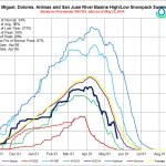
At a minimum, the draft “basin implementation plan,” or BIP, is full of compelling facts, figures, projections and projects. It also explores and explains broader themes and lists important projects in the Roaring Fork River watershed, including potential dams on upper Castle and Maroon creeks.

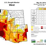
On the defining-factoid front, consider that 80 percent of the water in Colorado originates on the Western Slope, while 80 percent of the state’s population lives east of the Continental Divide, mainly in cities on the Front Range.

This explains much of the underlying tension in the plan between shipping more water to the Front Range versus leaving it in rivers, or using it, on the Western Slope.

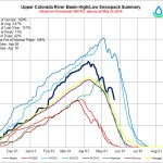
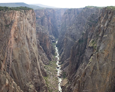
The Colorado River originates in Rocky Mountain National Park and it, or its tributaries, run through Grand, Summit, Eagle, Pitkin, Garfield and Mesa counties on the river’s journey out of the state and onto Utah, Arizona, California and Mexico.

Before the river reaches Glenwood Springs, though, there are more than a dozen tunnels under the Continental Divide that take between 400,000 to 600,000 acre-feet of water each year from the Colorado River and its tributaries to cities and farms on Colorado’s Front Range.

An acre-foot of water, by the way, is equal to an acre of land covered by a foot of water. Ruedi Reservoir holds about 100,000 acre-feet. Paonia Reservoir holds about 15,000 acre-feet. The abbreviation “AFY” means acre-feet-per-year.

When people water their lawns in Denver or Colorado Springs, they are likely using water from the Fraser, Blue, Roaring Fork or Fryingpan rivers, all tributaries to the Colorado River.

Folks on the Western Slope are diverting plenty of water out of Western Slope rivers, too, mainly to grow hay.

Agriculture uses 85 percent of the water diverted from rivers in Colorado, and the most senior water rights are usually tied to ag land.

The Colorado River Basin has 268,000 acres of land under irrigation, or 8 percent of the irrigated land in Colorado, resulting in a consumptive use of 584,000 acre-feet-per-year of water.

So, in rough terms, of all the water diverted from rivers and streams in the Colorado River Basin, almost half goes to Front Range cities and farms and almost half goes to irrigate fields and crops in the basin.

Some of the water goes toward “municipal and industrial” uses, which includes residential use.

There are 54 water-providing utilities and organizations in the Colorado Basin.

In 2008, those providers delivered 68,480 acre-feet to houses, factories and ski areas.

That demand for “municipal and industrial” water is expected to double, or more, to between 129,940 to 179,440 AFY by 2050, according to the draft plan from the Colorado roundtable.

Local water, state water

While it may not be obvious, the development of a basin-wide and a state-wide water plan is indeed a local story, as the Roaring Fork River valley is in the thick of the debate over the future supply of water for the state’s growing population.

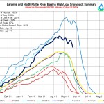
Water from the Roaring Fork River watershed, which includes the Fryingpan River, is diverted east each year to Colorado Springs, Aurora and Pueblo through the Fryingpan-Arkansas and Twin Lakes projects.

“On average, 37 percent of the upper Roaring Fork watershed (40,600 AFY) and 41 percent of the upper Fryingpan watershed (61,500 AFY) is currently diverted annually to the Front Range,” the plan notes. “These are the 5th and 3rd largest transmountain diversions, respectively, in the state.”

These diversions mean that about 100,000 AFY of water does not flow each year down to the confluence of the Roaring Fork and Colorado rivers in Glenwood Springs as nature intended, but instead flows east, as water managers intend.

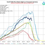
There are eight other river basins in Colorado, and the appointed roundtables in each basin, meeting under the auspices of the Colorado Water Conservation Board, are also developing their own BIPs.

Each plan is supposed to inform the state of the needs and potential water projects in each basin, and the basin plans will be incorporated into a statewide Colorado Water Plan.

The roundtable in the South Platte River Basin on the Front Range, and another roundtable representing metro Denver, are both likely to mention in their plans that new supplies of Western Slope water — meaning more dams and reservoirs — must be developed to meet the water needs of the state’s growing population.

Colorado’s population is expected to grow from 5.1 million today to between 8.6 and 10 million by 2050, according to state estimates, with most of that growth happening on the Front Range.

But the population on the Western Slope and in the Colorado River Basin is also expected to grow significantly, especially along the Interstate 70 corridor. The population in the Colorado River Basin was 307,000 in 2008. It is expected to climb to 661,000 to 832,000 by 2050.

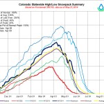
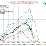
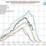
The state has estimated that by 2050 there could be a “gap” between water demand and water supply of some 500,000 acre-feet in the state. Many members of the Colorado Basin Roundtable, which meets monthly in Glenwood Springs, question the validity of the size of the gap.

Even without a big new water-supply project being developed, the plan from the Colorado roundtable points out that many other smaller projects already in the works will divert even more water from the Colorado Basin. Many existing diversions could take more water, and may do so in the future, in a process known as “firming up yields.”

“It is currently estimated that an additional 150,000 AFY will be diverted in the future as Front Range diverters firm up yields in the future,” the plan states. “These additional planned firming projects include: the Moffat Collection System Project, Windy Gap Firming, Eagle River memorandum of understanding, Future Dillon Reservoir diversions, firming in the upper Roaring Fork and Fryingpan Rivers, and Colorado Springs Utilities expanded diversions from the Upper Blue River.”

Both the Fry-Ark project and the Twin Lakes project own conditional water rights that could be developed in the future, meaning more water could be diverted from the Roaring Fork and Fryingpan headwaters.

And yet, the Colorado Basin Roundtable’s plan is adamant that there is no more water to divert from the basin.

Tapped out?

“The Colorado Basin has played more of a role in solving Colorado’s water shortage than any other basin in the state,” the plan states. “These transmountain diversions have had a dramatic impact on the health of our ecosystems, economy and culture of the headwater counties of the Colorado Basin. The headwaters are tapped out.”

The plan, in another section, also plainly says that “there is no more additional water to support other basins into the future.”

The basin roundtable has also articulated a set of “Western Slope Principles,” chief among them is that “Colorado Water Plan solutions should originate first in the basin in which the problem exists.”

In other words, if the Front Range wants to keep growing, it has to find water in its own basin, not look to the Western Slope.

But throughout this planning process, Front Range interests have generally said it would not be a good idea to take any long-term options off the table.

The Colorado Basin plan also calls for the state of Colorado to remain neutral in the grand east-west fight over water.

“The state should act as a facilitator — not an advocate — in inter-basin conversations surrounding transmountain diversions,” the plan states.

The plan also makes a strong call for growth control in the Colorado Basin and the state.

“A strong link should be made between land use patterns and water use together in a meaningful and binding way,” the plan states. “Land use and growth should be directed within urban growth boundaries where water supply plans are currently in place. Land use planning across the basin should recognize the shortage and limits of water supply.”

It also notes, in an apparent dig at Front Range lawns, that “the land use policies of the future must recognize that preserving water for streams and rivers and maintaining agriculture is more important than watering outdoor landscapes.”

New reservoirs?

The Roundtable’s “basin implementation plan” clearly recognizes the need for new reservoirs to meet the needs of both agricultural and municipal needs, and it provides a list of potential new dams and reservoirs, albeit relatively small ones, across the sub-regions in the basin.

It also recognizes that building new reservoirs is going to be challenging, especially for municipal water utilities.

“Many of these water providers’ long term water supplies are based on conditional storage rights for on-stream reservoirs,” the plan states. “Today’s regulatory and permitting climate makes the construction of channel reservoirs virtually impossible.

“Even if they can be permitted as an off-channel reservoir, the expense for any one small utility is cost prohibitive,” the plan states. “Therefore many utilities are discontinuing the diligence filings on these on-channel reservoirs.”

The city of Aspen’s water utility, however, is not walking away from its conditional water rights for dams and reservoirs on upper Castle and Maroon creeks.

In fact, the city has been advocating for the two potential dams and reservoirs to be included in the basin’s draft plans and it has stated in the past it intends to keep the option open to build the reservoirs.

The dams on Castle and Maroon creeks are indeed mentioned in the draft basin plan, which was released by SGM on May 16.

The dams are listed in regional tables that SGM describes as “examples of projects that each region identified from the full list as being a top candidate for the Colorado Basin Roundtable.”

The table for the Roaring Fork region is on page 71 of the plan.

Under the column entitled “themes and supporting vulnerabilities,” it lists “Storage for supply assurance during low flow periods” under the subhead of “Secure Safe Drinking Water.”

The next column over is called “methods,” and here the plan recommends that the city should “investigate the development of storage reservoirs in both Maroon and Castle creeks if no better alternative is discovered.”

And under the column heading of “Projects,” it recommends the city “continue due diligence for the preservation of the 1972 storage rights on Maroon and Castle creeks by giving true consideration to all other potential options.”

Aspen is required in 2015 to file a diligence report with the state showing it is making progress toward building the dams and reservoirs.

While the statements in the draft basin plan would seem to give support for the idea of building a dam within view of the Maroon Bells, the plan also throws plenty of cold water on the idea of new dams in the high country to meet municipal needs.

“Water providers in the upper reaches of the basin are dependent upon direct flow stream intakes and are susceptible to extended drought periods,” the plan notes about water utilities in the Roaring Fork River watershed.

“Because the watersheds above these intakes are primarily located on U.S. Forest Service lands and because of the strong environmental ethics present, the likelihood of construction of reservoirs above intakes is small.

“These water providers should seek redundancy through other means including: enlargement of existing reservoirs, interconnects between regional water providers, development of well supplies and reliance upon multiple stream water supplies,” the plan states.

While the Castle and Maroon creek dams are mentioned in the section of the report that focuses on the Roaring Fork watershed, the primary emphasis in that section is about the lack of water in certain sections of local rivers.

“The primary need of the Roaring Fork watershed is to protect, maintain, and restore healthy rivers and streams,” the plan states. “Almost 140 of 185 miles of streams surveyed in the Roaring Fork watershed have moderately modified to severely degraded riparian habitat.”

The plan further notes that “there are three critical reaches of main streams that have been targeted for restoration 1) the Roaring Fork River below the Salvation Ditch through the city of Aspen; 2) the Roaring Fork River upstream of the confluence of the Fryingpan River, and 3) the Crystal River upstream from Carbondale.

“These three main reaches do not include all the smaller tributaries in the upper Fryingpan and the upper Roaring Fork that have been dried up due to transmountain diversions,” the plan states.

The plan then lists many water projects, some physical and some policy oriented, for the Roaring Fork basin and the five other sub-basins in the Colorado Basin.

The next step for the BIP is for the members of the Roundtable to review it at meetings in June. Then the draft is to be sent in July to the Colorado Water Conservation Board for its review.

In the meantime, if you want to dig deeper into your water future, go to SGM’s website at http://coloradobip.sgm-inc.com/ and look for the plan under the “Resources” tab.

More Colorado Water Plan coverage here.

Water Information Program: Colorado water history, law and infrastructure

Smith Ditch Washington Park, Denver

From the Glenwood Springs Post Independent (Denise Rue-Pastin):

The history of the Colorado River mirrors the history of the American West. Competing water uses from the Colorado River system have defined Colorado history for more than 100 years. As people around the state discuss how to manage water resources into the future, it is instructive to look back at the formation of the practices that govern allocation of the state’s water. This overview is provided by the Durango-based Water Information Program, on the Web at http://www.waterinfo.org.

FIRST IN TIME, FIRST IN RIGHT

The legal right to divert and use water in Colorado has been deliberated and defined from before the time of statehood in 1876. As stated in the state Constitution, “Prior appropriation shall give the better right as between those using the water for the same purpose …” This is the basis for the first in use, first in right doctrine of water appropriation, which is one of the legal foundations upon which water is managed in Colorado.

The Colorado Water Conservation Board (CWCB) oversees water issues in the State of Colorado, and the Colorado Division of Water Resources administers water allocation in accordance with court decrees and state legislation. The State Engineer’s office has maintained meticulous records on water usage, diversions and streamflows for many years. Two-hundred professional staff members work together to administer Colorado’s water according to the doctrine of prior appropriation, state law, water court decrees and interstate compacts.

BIRTHPLACE OF RIVERS

Colorado has the enviable position in the West as being a water-producing state, with numerous mountain ranges capturing the winter snows that feed our streams and rivers. The seasonal nature of streamflows is not consistent with the demand by Colorado citizens for domestic, agriculture and industry uses. Nearly two-thirds of the annual water flow occurs during the late spring/early summer runoff. During the winter months of December, January and February only 3 percent of annual flows occur.

Colorado reservoirs store the spring runoff from mountain snowpack for use in the late summer and low-flow winter months. This “reserved” water is stored for use throughout the year by downstream users. In addition, water storage units along the Colorado River system provide flood control, recreational sports, excellent fishing and hydro-electric power.

‘LAW OF THE RIVER’

Water leaving Colorado on an annual basis exceeds 10 million acre feet. The Colorado River west of Grand Junction provides nearly 5 million acre feet of that amount for downstream users. The Colorado River Compact is the ruling document that was established after long negotiations between the seven states along the Colorado River in 1922.

After the U.S. Supreme Court ruled that the waters of the Colorado River would be governed according to the Doctrine of Prior Appropriation, the Upper Basin states (Utah, New Mexico, Wyoming and Colorado) became concerned that the Lower Basin states (California, Arizona and Nevada) would be at an unfair advantage if this doctrine was applied across state lines due to the Lower Basin’s more rapid development of water resources.

As a result of complex negotiations between the states in a forum called the Colorado River Commission, the elements of the famous Colorado River Compact were forged between the seven states along the Colorado River system. Under this compact, the Upper Basin states are required to allow an average of 7.5 million acre-feet per year flow downstream from Lake Powell to the Lower Basin States — theoretically splitting the rights to the river’s total flow in half, although in recent decades the total yield of the river has typically been considerably lower than the amount assumed by compact.

Although the Colorado River Compact formed the basis for the “Law of the River,” much debate and deliberation was to follow the historic 1922 treaty. For example, Wyoming challenged Colorado’s right to divert headwaters streamflow from the west to east slope of Colorado.

In 1944, a treaty was signed with Mexico providing our neighbor to the south with 1.5 million acre feet annually from the Colorado River system. In 1948, the Upper Basin States agreed to a percentage appropriation of their share of the waters of the Colorado River System. Colorado’s share was set at 51.75 percent.

DAMS & CANALS

In 1902, the U.S. Bureau of Reclamation (USBR) was created. Ever since, the USBR has been coordinating the planning, construction and implementation of numerous water diversion and storage projects in the western United States. Irrigation projects throughout the West are based on contracts between the water users and the USBR. Hydro-electric power revenues are used to offset some of the costs of irrigation projects and repayment contracts. The USBR manages existing water reservoirs in the Colorado River System that were constructed with federal financing.

Present and future generations will continue to wrestle with the issues of how to allocate the Colorado River between competing demands. Indian water rights, endangered species, water quality, interstate conflicts and environmental legislation are among the factors that must be considered. Over the past 100 years, the history of water in Colorado has helped shape the “Law of the River” throughout the Basin and our state. How we manage, conserve, store and distribute water will remain one of Colorado’s most pressing policy challenges, with implications beyond our borders.

Just 15 years ago, it was unthinkable that the [CWCB] would be in the fire business — @ChrisWoodka @CO_H2O


From The Pueblo Chieftain (Chris Woodka):

Just 15 years ago, it was unthinkable that the Colorado Water Conservation Board would be in the fire business. But the wildfires that have broken out since 2000 have been larger and more destructive than any in Colorado’s history — including their impact on watersheds the state’s 5 million people depend on.

“Prior to 2000, the largest fire had been 26,000 acres, and that happened in 1879,” said Kevin Houck, watershed and flood protection chief for the CWCB said Thursday at the board’s Pueblo meeting.

Since then, the state has witnessed the Hayman Fire (southwest of Denver), 2002, 137,760 acres; West Fork complex (near Creede) 2013, 110,405 acres; and High Park (west of Fort Collins) 2012, 87,284 acres.

In fact, 28 of the 30 largest wildfires have occurred since 2000.

In addition, 14 of the 15 most destructive fires have been since 2000. These include the Black Forest Fire (509 homes) in 2013, near Colorado Springs; Waldo Canyon (346 homes) in 2012, near Colorado Springs; the High Park Fire (259 homes); and the Fourmile Fire (169 homes) in 2010 north of Boulder.

Many of the fires impact watersheds, including Waldo Canyon, which sent sheets of mud into Fountain Creek last September, and the Hayman Fire, which has caused debris flows for years into Denver and Aurora reservoirs.

Houck praised Canon City officials for the quick response to the aftermath of the Royal Gorge Fire. Last year, the CWCB provided a $485,000 grant for mulching and planting to reduce the impact on Canon City’s water supply.

“The city only used about two-thirds of the grant, so we may get some back,” Houck said. He provided a list of more than $1 million in watershed restoration grants just to deal with fires in 2012-13.

After the East Peak Fire, Huerfano County continues to worry about dry conditions.

Tom Spezze, of the Rio Grand Watershed Emergency Action Coordination Team, gave the board an update on its actives to deal with water quality issues associated with the West Fork Complex and to prevent future fires.

Such fires not only affect water supply, but local economies as well, Spezze said. Creede lost 75 percent of its tourism revenue last July and was 40 percent off for the year.

The fire has left uncertainty in a private tourist camp that operates on federal land near a canyon now prone to flooding.

But the debris and silt after a fire is immense.

“We’re not sure what’s going to happen,” Spezze said. “The debris in one year filled Humphreys Reservoir. It had just been dredged for 25 years’ worth — all for naught.”

Weather news: Impressive rain totals on the north side of Colorado

Click on a thumbnail graphic to view some precipitation data from this morning. The orange dots on the CoCoRaHS map are upstream from Weld County.

Rifle Gap Reservoir proposed management plan undergoing review process #ColoradoRiver

Rifle Gap Reservoir via the Applegate Group

Here’s the release from Colorado Parks and Wildlife:

Colorado Parks and Wildlife has submitted its Rifle Gap Reservoir Proposed Lake Management Plan to several of its partners in the Upper Colorado River Endangered Fish Recovery Program, including the U.S. Fish and Wildlife Service and the wildlife agencies of the States of Utah and Wyoming. Approval by these partners is the last required step to establish future stocking plans for the popular fishery.

Lake Management Plans describe objectives for specific fisheries, including which species will be stocked and managed. The Rifle Gap Proposed Lake Management Plan was crafted in accordance with the ‘Procedures for Stocking Non-native Fish Species in the Upper Colorado River Basin’, a cooperative agreement between program partners.

The goal of the Upper Colorado River Endangered Fish Recovery Program is the recovery of four endangered fish found only in the Upper Colorado River Basin, the razorback sucker, bonytail chub, humpback chub and the Colorado pikeminnow.

“We developed the management plan with input we received at a public meeting in 2010 and comments we have received since then,” said CPW Aquatic Biologist Lori Martin. “Public feedback was critical to form what we feel is a very good vision for future fisheries management of Rifle Gap.”

Rifle Gap Reservoir currently features both cold and cool/warm water species, including rainbow and brown trout, walleye, smallmouth bass, yellow perch, northern pike and black crappie. Walleye and smallmouth bass have self-sustained in the reservoir since they were stocked by the former Colorado Division of Wildlife in 1972, prior to the existence of the Recovery Program. No additional smallmouth bass, walleye, or any other cool/warm water species have been stocked by state wildlife managers since the initial introduction.

Until the proposed LMP is approved, CPW may not stock any fish species other than trout into Rifle Gap Reservoir, under the terms of the ‘Procedures for Stocking Non-native Fish Species in the Upper Colorado River Basin’.

“CPW will remain judicious in terms of which sport fish species will be stocked and managed as we continue our native fish recovery efforts,” said Northwest Region Senior Aquatic Biologist Sherman Hebein. “That is our responsibility as partners in the program.”

As currently written, the proposed LMP allows for the introduction and management of black crappie, yellow perch, rainbow and brown trout and triploid walleye, all non-native sport fish which are compatible with Recovery Program goals. The triploid version of walleye is sterile and typically grows faster than non-sterile walleye because energy is devoted to growth rather than reproduction. This makes the species attractive to many anglers as well as the Recovery Program.

Because of their severe impacts to native fish, smallmouth bass and northern pike are considered ‘non-compatible’ with recovery efforts. Further introduction or stocking of these species in the Upper Colorado River Basin is strongly discouraged by the Recovery Program.

“This is a good proposed plan and has the potential to lead to an even better fishery than we have now,” said Rifle Gap State Park Manager Brian Palcer. “CPW manages our parks and our wildlife together with the public’s input and cooperation and that worked well as the plan came together; however, we will also need cooperation from the public into the future to maintain Rifle Gap as a destination fishery.”

CPW officials add that the public’s support will not only help with recovery efforts for native fish, it will also facilitate continuing efforts to bring quality sport fishing to Western Colorado.

“We have a biologically sound LMP proposed for Rifle Gap,” said CPW Area Wildlife Manager JT Romatzke. “We thank everyone that has contributed to this plan. We are doing what we can to give our anglers a variety of opportunities while simultaneously meeting the requirements of the Recovery Program.”

The Rifle Gap Reservoir Proposed LMP will undergo a 60-day review process. During this time period, Recovery Program partners will have the opportunity to add comments and revise as necessary before granting final approval.

For more information about the Rifle Gap Proposed Lake Management Plan, visit http://www.cpw.state.co.us/learn/Pages/RifleGapReservoirManagement.aspx, or contact CPW Aquatic Biologist Lori Martin at lori.martin@state.co.us.

More endangered/threatened species coverage here.

CWCB: May 2014 Drought Update

Click here to read the May 2014 update from the Colorado Water Conservation Board. Here’s an excerpt:

Drought conditions remain in southern Colorado, but have abated in much of the northern portion of the state. While April was slightly warmer than normal, May to date has been cool and wet helping to slow melt off, and in some instances improve, snowpack. Reservoir storage is high in the north but well below average in the southern half of Colorado. Agriculture in this region is also struggling to establish a good crop due to lack of soil moisture. Relief is possible as ENSO conditions favor the return of El Nino conditions, which historically has meant increased moisture for Colorado. Water providers indicated that storage levels are decent, and they are not imposing above normal watering restrictions, yet they will continue to closely monitor conditions.

  • Currently, 55% of the state is in some level of drought classification according to the US drought monitor. 22% of that is characterized as “abnormally dry” or D0, while an additional 14% is experiencing D1, moderate drought conditions. 6% is classified as severe, 11% as extreme and 2% of the state remains in exceptional drought (D4). In comparison, this time last year 100% of the state was experiencing some level of classification (D0-D4).
  • Snowpack statewide is at 105% of median. All basins saw some decline in April due to seasonal melt off and below average precipitation. As of May 15, the basin with the highest snowpack is in the North Platte Basin at 126% of median. The Rio Grande has the lowest snowpack in the state at 84% of normal. The snowpack in the San Miguel/Dolores/San Juan Basin is also below average at 88%. The South Platte, Colorado, Yampa/ White, Gunnison and Arkansas are near or above normal at 120, 112, 113, 102 and 97 % respectively.
  • Current streamflow forecasts statewide range from well below to well above average, with the northern portion of the state showing higher forecasts than the south.
  • Reservoir Storage statewide is at 93% of average at the end of April 2014. The lowest reservoir storage statewide is in the Arkansas & Upper Rio Grande basins, with 59% and 67% of average storage, respectively. The South Platte has the highest storage level at 110%.
  • ENSO conditions are likely to transition El-Nino in the coming weeks and are forecast to bring more moisture to the lower elevations during the growing season. The forecast through June indicates that the mountains are less likely to benefit from wet conditions, with the exception of the western San Juan Mountains.
  • The Surface Water Supply Index (SWSI) for the state, which takes into account both reservoir storage and streamflow forecasts, is near normal across much of the state, with an “abundant” index in the northern basins of the South Platte, North Platte, Yampa/ White and Colorado. The lowest values in the state are in the Arkansas and are the result of poor reservoir and streamflow conditions for the Cucharas and Huerfano rivers.
  • Southern portions of the state continue to deal with the effects of a multi-year drought, including low soil moisture and blowing dust. Producers in southeastern Colorado are concerned about how another year of below average precipitation may impact their operations.
  • More CWCB coverage here.

    Water Infrastructure Bill Passed by Senate — The Wall Street Journal

    Water infrastructure as sidewalk art
    Water infrastructure as sidewalk art

    How many projects will actually receive appropriations?

    From The Wall Street Journal (Kristina Peterson):

    The Senate overwhelmingly passed a water infrastructure bill on Thursday, approving the first legislation since 2007 that authorizes new port, dam and flood-protection projects.

    The House earlier this week passed the bill, the product of bipartisan negotiations merging versions passed by each chamber last year. The legislation, one of the rare recent instances of both chambers approving bills through traditional procedures and without the pressure of an imminent deadline, now heads to President Barack Obama.

    The water infrastructure bill, passed on a 91-7 vote, includes a long-stalled project to expand the Savannah Harbor to accommodate bigger ships once the Panama Canal expansion is completed. The bill also authorizes projects deepening and making other improvements to Boston Harbor and Palm Beach Harbor in Florida.

    Congress first authorized expanding the Savannah port in 1999, but the project has stalled and estimated costs have risen in the years since. The water bill authorizes $706 million, of which $492 million would come from the federal government. The next step is for the U.S. Army Corps of Engineers to complete a project partnership agreement with the Georgia Ports Authority detailing the construction plans.

    More infrastructure coverage here.

    Aspen Journalism: What people are saying about the #COWaterPlan so far?

    @ConservationCO: Congratulations to Melinda Kassen, this year’s Rebel with a Cause

    Denver Water and the DWR reach agreement for Dillon Reservoir to mitigate flood risk along the Blue River should the need arise

    Denver Water employees Rick Geise and Nate Hurlbut assisted in setting the plug, which helps prevent chunks of ice and snow from falling into the spillway. Photo credit: Denver Water

    From the Summit Daily News (Joe Moylan):

    The Colorado Division of Water Resources recently signed off on a first-of-its-kind proposal that could significantly reduce the risk of catastrophic flooding events in Summit County.

    The plan, proposed by Bob Steger, manager of Raw Water Supply for Denver Water, would allow the state’s largest water utility to divert excess flows from Lake Dillon to the Front Range by way of the Roberts Tunnel in order to prevent a destructive water event in Summit County, most notably in Silverthorne.

    Summit County Emergency Management director Joel Cochran said earlier this month during a Summit County Commission workshop that record snowpack combined with unseasonably warm spring and early summer temperatures could cause flooding on a magnitude not seen in two decades in the Blue River Watershed.

    According to data Cochran presented during the commission’s first meeting in May, this season’s total snowpack consists of the equivalent of 17 to 20 inches of rainwater. It’s the highest concentration of snowpack in Summit County since 1995, the last year there was significant flooding in Summit County, Cochran said.

    In addition to record snowpack, Cochran said spring and early summer temperatures are hovering between 6 and 10 degrees above normal throughout the state. Although Summit County last week caught a break from unseasonably warm temperatures, the return of spring has local officials concerned that the runoff could be triggered earlier than usual.

    Historically, runoff in Summit County begins the first week of June, peaks about the middle of the month and ends before early July, Cochran said.

    However, floods aren’t triggered by mountain runoff or even an accelerated runoff, Cochran said.

    “A lot of people remember 2011 when we lost Coyne Valley (Road), but you can’t have (extreme) flooding due solely to spring runoff,” Cochran said. “We lost Coyne Valley because we had a major rain event when the Blue River was at peak water.”

    With this season’s snowpack, it’s almost a certainty the Blue River will reach its capacity of 1,800 cubic feet per second of water at some point in the coming weeks, said Summit County assistant manager Thad Noll. If Summit County receives a significant rain event while the Blue is peaking, the damage could be extensive all over the county, but particularly in Silverthorne.

    “Silverthorne got by relatively unscathed once in the past when the Blue reached 2,100 cfs, but anything higher than that and we’re trying to keep Silverthorne from getting washed down to the Sea of Cortez,” Noll said. “Denver Water’s proposal would relieve that pressure on the Blue by sending excess water to Denver in the event of a flood.”

    That water would be transported by way of an underground aqueduct known as the Roberts Tunnel, which was constructed to carry water more than 23 miles from Lake Dillon to the North Fork of the South Platte River, where it is then distributed to several other reservoirs in and around Denver. Each year, water from the Blue River and Lake Dillon accounts for about 40 percent of the water annually collected and stored on the Front Range.

    The South Platte’s capacity is about 680 cfs, according to a letter by Steger, which means up to that much water could be sent through the tunnel to the Front Range. Depending on South Platte flows, the water diverted downtown could relieve a significant amount of strain on the Blue River should it reach critical mass.

    However, prior to receiving approval, Noll said the idea sparked an interesting debate among West Slope water advocates who opposed the proposal. Although Lake Dillon is owned and operated by Denver Water, it was previously prohibited from sending water to the South Platte if Front Range reservoirs were full.

    Opponents were particularly critical of the idea to divert water to Denver considering Front Range reservoirs are expected to reach capacity this year.

    “It raises an interesting question because the Blue River’s natural flow is toward the Colorado River,” Noll said. “The debate was whether saving the tiny town of Silverthorne, Colorado supersedes the rights of stakeholders down the line.”

    The Colorado Office of the State Engineer thinks that it does, so long as Denver Water doesn’t cause flooding on the Front Range in trying to prevent the same in Summit County.

    More Blue River watershed coverage here.

    Releases from the Aspinall Unit to Increase Temporarily to Benefit Endangered Fish #ColoradoRiver

    Black Canyon via the National Park Service
    Black Canyon via the National Park Service

    Here’s the release from the Bureau of Reclamation (Erik Knight/Justyn Hock):

    Reclamation will begin increasing releases from the Aspinall Unit, consisting of Blue Mesa, Morrow Point, and Crystal reservoirs on the Gunnison River, on May 23, 2014, as required by the Record of Decision for the Aspinall Unit Operations Final Environmental Impact Statement. The increased release will attempt to meet flow targets on the Gunnison River, designed to benefit endangered fish species downstream while continuing to meet the congressionally authorized purposes of the Aspinall Unit.

    Beginning on May 23, 2014, flows in the Gunnison River through the Black Canyon will begin increasing at a minimum of 500 cubic-feet-per-second a day resulting in flows through the canyon of around 9,000 cfs on June 2, 2014. Flows will remain at or above 8,000 cfs for 10 days before incrementally decreasing toward a range of 4000 cfs to 5000 cfs by the middle of June 2014.

    More Aspinall Unit coverage here.

    Northwest Pipe Co. is major supplier for the Southern Delivery System #ColoradoRiver

    Southern Delivery System construction celebration August 19, 2011 via The Pueblo Chieftain
    Southern Delivery System construction celebration August 19, 2011 via The Pueblo Chieftain

    From The Denver Post (Aldo Svaldi):

    Orders at the Northwest Pipe Co. plant in Denver were drying up in 2010 when bid requests started coming for a massive water project linking the Pueblo Reservoir and Colorado Springs called the Southern Delivery System.

    “The start of the SDS project couldn’t have come at a better time,” Northwest’s vice president of sales Eric Stokes said.

    At a cost of $841 million, the water project is the largest the region has seen in decades. Starting in 2016, it will pipe water held in the Pueblo Reservoir to consumers in Colorado Springs, Pueblo West, Security and Fountain.

    “This is our water security for many years to come, 50 years into the future,” said John Fredell, program director of the water services division for SDS.

    Northwest Pipe’s Denver plant won almost all the contracts to supply 50 miles of steel pipe, and the company celebrated the completion of the last piece Thursday afternoon. Northwest produced 7,000 pieces of the pipeline, each averaging 50 feet in length and 66 inches in diameter. The orders allowed Northwest’s employment in Denver to grow from 116 full-time workers to more than 231 at the peak of manufacturing.

    Of about $500 million spent so far on the project, $359 million has gone to 333 Colorado businesses, including more than 75 based in metro Denver, Fredell said.

    Northwest Pipe alone received about $110 million, including $23 million spent on payroll. Given that the next closest competitor was in California, Stokes said Northwest had a distinct advantage.

    “Proximity was part of it,” Fredell said.

    Back in 1997, Northwest Pipe, which is based in Vancouver, Wash., acquired Thompson Pipe & Steel Co., a manufacturer with Denver roots going back to the late 1800s. For decades, Thompson built pipes in the Curtis Park area that continue to help move water across much of the state. Thompson moved its plant to a 45-acre facility at 6030 Washington St., where workers continued to convert steel coil arriving by rail car into water pipes shipped out on trucks.

    Once formed, the pipes are pumped full of water and pressure-tested to ensure there are no leaks. They are moved into a cavernous ⅛ – mile-long warehouse where they are rotated rapidly while concrete is poured inside to make a lining designed to last for decades. In a third building, the pipes are primed, painted and prepared for shipping.

    “It is nice to know you have finished on time,” said Jason Cheng, a welder from Westminster who joined Northwest in October to work on the SDS order.

    Cheng and other workers lined up to sign the last piece of pipe, undeterred as the rain poured down Thursday afternoon. Their signatures, in white ink, quickly smeared down the bright-blue pipe.

    “We want the water on the inside of the pipe, not the outside,” one person commented.

    From the Denver Business Journal (Cathy Proctor):

    Northwest Pipe, (Nasdaq: NWPX) is based in Vancouver, Washington. Its Denver manufacturing plant had a $110 million contract to build the project’s 50 miles of pipeline to carry the water. It was the biggest contract for materials under the project.

    Northwest Pipe started making its 50-foot sections of pipe for the project, each section 66 inches in diameter, in 2011.
    And the last pieces are now coming off the manufacturing line and awaiting a truck for transport to the project site.

    “This is one of the largest programs that we’ve seen,” said John Moore, manager of Northwest Pipe’s manufacturing plant at 6030 N. Washington St. in north Denver.

    During peak production, as many as 25 trucks a day left Northwest Pipe’s manufacturing facility.
    Being in Denver meant trucking costs were less and Northwest Pipe could submit a more competitive bid for the project, Moore said.

    And the project meant jobs for Northwest Pipe, which ramped up to 231 people during peak production, from a low of 116 people prior to work on the project, said John Moore, the plant manager. The company currently has 131 people on staff.
    Northwest Pipe, which supplies pipes to carry water and waste water, has delivered pipes to other big water providers, including Denver Water and Aurora.

    More Southern Delivery System coverage here.