Colorado receives HUD approval on state plan to spend $62.8 million on #COflood recovery

Flooding St. Vrain River September, 2013 via Voice of America

Here’s the release from the US Department of Housing and Urban Development and Governor Hickenlooper’s office (Val Beck, Charlene Guzman):

The U.S. Department of Housing and Urban Development (HUD) today announced it approved Colorado’s Community Development Block Grant – Disaster Recovery (CDBG-DR) Action Plan. The Plan outlines how Colorado will distribute $62.8 million in grant dollars received from HUD for flood recovery programs.

During a visit in December, HUD Secretary Shaun Donovan announced the funding award and that it would go toward needs not addressed through other sources of public and private assistance such as the Federal Emergency Management Agency and Small Business Administration.With acceptance of this disaster action plan the long-term and sustainable disaster recovery can continue.

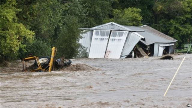
This grant will support recovery efforts in 18 Presidentially declared flood-impacted counties, with a majority of the funds going to the most impacted counties: Boulder, Larimer and Weld. Programs will focus on housing, public infrastructure, long-term planning and economic development and, as stipulated by the grant, 50 percent of the funds will be distributed to low- and moderate-income households.

“We are very pleased with this approval of our action plan for the $62.8 million in CDBG-DR funding. We greatly appreciate the efforts of HUD in working with our team to get to this as quickly as possible,” Hickenlooper said. “This grant will support long-term and sustainable disaster recovery efforts in the most impacted communities devastated by last year’s floods. The plan was developed with feedback from those impacted communities and will give Coloradans another resource to rebuild better and stronger.”

“From the moment the Presidential disaster declaration was made, HUD has been on the job, working with Congress to speed these much-needed funds to the State of Colorado,” HUD Rocky Mountain Regional Administrator, Rick M. Garcia said. “This funding is vital to helping Coloradoans rebuild their communities and HUD has been proud to partner with the State of Colorado and FEMA in this process.”

Applications for the funds will be available Friday, May 2, online at http://dola.colorado.gov/cdbg-dr/. The State will work with all applicants to release the money as soon as possible.

From the Longmont Times-Call (John Fryar) via the Loveland Reporter-Herald:

Programs funded by the Community Development Block Grant-Disaster Recovery grant are to focus on housing, public infrastructure, long-term planning and economic development, with 50 percent of the funds distributed to programs benefiting low- and moderate-income households affected by last September’s floods.

“We are very pleased with this approval of our action plan for the $62.8 million,” Gov. John Hickenlooper said in a Wednesday morning statement.

“This grant will support long-term and sustainable disaster recovery efforts in the most impacted communities devastated by last year’s floods,” Hickenlooper said. “The plan was developed with feedback from those impacted communities and will give Coloradans another resource to rebuild better and stronger.”

The state now will formally accept applications from communities for such programs as: household assistance, new housing construction, business grants and loans, agriculture grants, infrastructure repair grants, and strategic planning.

Colorado also is in line for getting another $199 million in federal CDBG-DR funds, and the state is preparing a separate action plan for spending that second round of flood recovery money.

Boulder County government and the county’s cities and towns have been working collaboratively on applications for the money they’re seeking from the first $62.8 million round of funding — an approach county officials said was intended to avoid local competitions for those dollars.

Bureau of Reclamation Water Management Video Series Highlights Collaborative Research

Pineapple Express conditions January 29, 2014 via NWS Boulder

Here’s the release from the US Bureau of Reclamation (Peter Soeth):

The Bureau of Reclamation is releasing a series of videos summarizing collaborative research addressing climate change and variability impacts, estimating flood and drought hazards, and improving streamflow prediction. This information was presented in January at the Second Annual Progress Meeting on Reclamation Climate and Hydrology Research.

“For more than 100 years, Reclamation and its partners have developed the tools to guide a sustainable water and power future for the West,” said Acting Commissioner Lowell Pimley. “This video series summarizes collaborative research that is another tool for Reclamation and its water users to manage water into the future.”

To kick off the video series, Reclamation is releasing four videos. They are:

  • Improving Stream Flow Prediction Across the Contiguous United States – Andy Wood, Ph.D., Hydrologist, National Center for Atmospheric Research
  • Tracking Pathways of Atmospheric Rivers – Michael Alexander, Meteorologist, NOAA Earth System Research Laboratory
  • Calculating Flood Risks at Our Nation’s Dams – Jason Caldwell, Meteorologist, Bureau of Reclamation
  • Examining Variability of Hydroclimate Extremes – Cameron Bracken, Hydrologic Civil Engineer, Bureau of Reclamation
  • The videos are available as a playlist at: http://bit.ly/climateseries.

    Reclamation’s Research and Development Office is developing the science and tools that are critical to incorporate information on long-term climate change into water resource planning and infrastructure management. Sustainable water resource management will rely upon management strategies that effectively deliver water under a changing climate as well as including hydrologic hazard possibilities on infrastructure. Improved ability to forecast and use climate variability information may greatly enhance the flexibility of water managers and water users to plan their short-term operations and water delivery.

    Research collaborators include Federal and non-Federal organizations, including members of the Climate Change and Water Working Group (http://www.ccawwg.us), NASA Jet Propulsion Laboratory, National Center for Atmospheric Research, University of Colorado CIRES and others.

    Additional videos will be released over the next few weeks in the same playlist. When posted, the video link will be shared on Reclamation’s Twitter and Facebook accounts. You can also follow by using the hashtag #climateseries. To see the videos once posted or learn more about the presentations, please visit http://www.usbr.gov/climate.

    To learn more about climate change and variability research please visit http://www.usbr.gov/research/climate.

    USGS: Current streamflow conditions nationwide

    Snowpack/runoff news: Colorado Springs Utilities will not impose watering restrictions this season #COdrought

    From The Colorado Springs Gazette (Monica Mendozq):

    A snowy winter in the Upper Colorado Basin is the city’s water savior. It’s the snowpack that fills Utilities’ reservoirs, which in recent years had dipped to below normal levels and had officials nervous about having enough water in storage for emergencies.

    Once this year’s snow melts, Utilities expects it will have 2.3 years of water in storage – or about 73 percent of capacity. That’s a pretty good place to be, said Abby Ortega, Utilities water planner.

    “We are expecting to fully recover storage levels to normal,” Ortega said.

    Still, Utilities will roll out a $600,000 conservation campaign encouraging residents to water their lawns three days a week or less.

    2014 Colorado legislation: SB14-192 passes the Senate #COleg

    Lincoln Park/Cotter Mill Site via The Denver Post
    Lincoln Park/Cotter Mill Site via The Denver Post

    From the Cañon City Daily Record (Christy Steadman):

    The Colorado Senate passed Senate Bill 192 on Tuesday, which concerns uranium licensing and groundwater protection, but causes conflict between Cotter Corp. Uranium Mill and Lincoln Park residents.

    In a press release issued by Conservation Colorado representative Chris Arend, residents of Lincoln Park “expressed support for (the) bipartisan legislation … that will help rectify 30 years of groundwater contamination by Cotter Corp.”

    “The passage of SB 192 today will help restore our use and rights to our wells and begin to rectify the damage the Cotter Corporation has caused in our community,” Sharyn Cunningham, Lincoln Park resident said in the release.

    John Hamrick, facility manager at Cotter Corp., said they have been in negotiations with the Environmental Protection Agency and the Colorado Department of Public Health and Environment to abide by the federal rules regarding “what is the best way” concerning clean-up. He said that is “now in jeopardy” because of SB 192, and a year-and-a-half of progress in the negotiation process will have to be discarded, and they will now have “to go back to zero.”

    “(Additionally), the State of Colorado is federally preempted from passing a law that requires the EPA to select a specific clean-up remedy,” Hamrick said.

    In the release, Lincoln Park resident Pete Maysmith said SB 192 “will help clean-up residents’ groundwater and restore the historic use of their water wells.”

    “No community should have to endure the long-term exposure to uranium and other contamination as the community of Cañon City has at the hands of the Cotter Corp.,” Maysmith said.

    Here’s a release from Conservation Colorado:

    Impacted residents and members of the Colorado conservation community expressed support for bipartisan legislation passed today that will help rectify 30 years of groundwater contamination by Cotter Corporation in Canon City, Colorado. Residents of the Lincoln Park neighborhood in Canon City had been told that the best way to deal with Cotter’s pollution was for the community to abandon use of their wells.

    “For my Lincoln Park neighbors forsaking our historic use of our water wells was never an option. We knew we needed to keep fighting for full and active clean up of our wells not only to restore our current rights but for future residents,” said Sharyn Cunningham, Lincoln Park resident. “The passage of SB 192 today will help restore our use and rights to our wells and begin to rectify the damage the Cotter Corporation has caused in our community.”

    “Today after 30 years of contamination and indifference, the residents of Lincoln Park saw significant movement in their campaign for the Cotter Corporation to finally clean up its mess in Cañon City,” said Pete Maysmith. “No community should have to endure the long term exposure to uranium and other contamination as the community of Cañon City has at the hands of the Cotter Corporation. The legislation passed today will help clean up residents’ groundwater and restore the historic use of their water wells.”

    Although pleased that contaminated water would be cleaned-up, supporters expressed concern that the Colorado Senate stripped out licensing requirements that would protect against future contamination.

    “We are disappointed in Colorado Senate amendments to remove important protections for experimental uranium milling proposed for our community,” said Cathe Meyrick, resident of the Tallahassee Area in Fremont County. “The legislation would have clarified that licensing is required before the industry deploys experimental uranium recovery techniques with potentially grave impacts on our groundwater. Regardless of this setback, we will rely on a committed community and look for other mechanisms to protect our groundwater.”

    The proposed new technologies involve extraction through the creation of an underground uranium slurry (i.e., underground borehole mining) and concentration through physical, rather than chemical means (i.e., ablation). These new uranium recovery methods are being proposed for uranium deposits in Fremont County (Tallahassee Area/Arkansas River) and in Weld County (Centennial Project and Keota).

    Both Conservation Colorado and impacted landowners in Fremont and Weld County will work to reinstate the provisions as the bill moves forward.

    More nuclear coverage here.

    April 24 “celebration lunch” for Colorado River Cooperative Agreement recap #ColoradoRiver

    Denver Water's collection system via the USACE EIS
    Denver Water’s collection system via the USACE EIS

    From the Sky-Hi Daily News (Leia Larsen):

    At a celebration lunch on April 24 at Devil’s Thumb Ranch in Tabernash, representatives from Denver Water, the Colorado Governor’s Office, Grand County and Trout Unlimited spoke in favor of the Colorado River Cooperative Agreement. Nearing its one-year anniversary this September, the agreement coordinates efforts between 18 interest groups to both protect West Slope watersheds while providing future water supplies to Denver customers. The celebration came in the wake of the latest development in the proposed Moffat Collection System, Denver Water’s latest trans-mountain water project.

    “(Our) overall goal is to protect the watershed and economies in the Colorado River Basin and help provide additional water security for those who live, work and play on the West Slope and (for) the customers of Denver Water,” said Jim Lochhead, CEO and Manager of Denver Water, at the lunch celebration…

    Denver Water will pay out $1.95 million in Grand County for watershed, water treatment and river habitat improvements. It will send another $2 million to Summit County. The agreement is being called “historic” for its unprecedented work in bringing together a wide range of interests throughout the state and for its “learning by doing” program of adaptive water management.

    “Working together, we were able to resolve historic conflicts through a holistic approach to resolving Colorado water disputes,” Lochhead said.

    According to John Stulp with Gov. John Hickenlooper’s office, the unprecedented water cooperation will also be used as a model for the statewide Colorado Water Plan, set to be ready by December 2014.

    “Part of the concerns we have, and why we need a water plan, is based on many of the same principles you had in this cooperative agreement,” Stulp said at the lunch. “Important … building blocks that went into this cooperative agreement (are) having good people with a broad vision of the future beyond their own community.”[…]

    Still, the agreement hasn’t eliminated all controversy. Part of the Colorado River Cooperative Agreement negotiations is that West Slope parties must agree not to oppose any permits for the Moffat Project, the latest trans-mountain diversion plan to move water from the Fraser watershed to the Denver-metro area…

    The U.S. Army Corps of Engineers released its final Environmental Impact Statement for the Moffat Project last week. It’s a massive document — the table of contents alone is over 60 pages and Wockner said it has around 11,000 pages total. So far, however, he said he hasn’t seen anything in the study to address the negative impacts to river systems in Grand County. Other environmental interests have also said even with the environmental impact statement, the Moffat Project is “far from a done deal.”

    “This project should not be approved unless the long-term health of the river is assured and our nation’s environmental standards are met,” said McCrystie Adams, a Denver-based attorney with Earthjustice, in a press release. “We and our partners are committed to keeping the Colorado River flowing.”

    Geoff Elliott, an earth scientist with the local firm Grand Environmental Services, said Denver Water presented bad data to begin with, stacking the numbers in its favor.

    “Their data is skewed to show more water in the Fraser Headwaters than now exists,” he said. “My problem is no one is doing math. Denver gets out with everything it wants.”

    Elliot said according to his analysis so far, the Moffat Project’s proposals compared with U.S. Geological Survey data on actual water flows means it could take 90 percent or more water out of the Fraser.

    “Now, we get hit by a 12,000-page Final EIS that requires an army to review,” he said. “This is Big Brother Denver Water hitting Grand County hard, and we are told we should be happy with vague platitudes, scraps of water and lawyerly agreements for more closed-door meetings.”

    More Colorado River Cooperative Agreement coverage here.

    Mesa Verde: Farview reservoir may have been a ritual site not water storage

    Farview Reservoir Mesa Verde NP
    Farview Reservoir Mesa Verde NP

    From Yahoo! (Joseph Castro):

    Mummy Lake is a sandstone-lined circular pit that was originally 90 feet (27.5 meters) across and 22 feet (6.65 m) deep. In 1917, American naturalist Jesse Walter Fewkes pegged the structure as a prehistoric water reservoir. Several subsequent studies of Mummy Lake have also supported this view, leading the National Parks Service to officially name the structure “Far View Reservoir” in 2006. (Far View refers to the group of archaeological structures located on the northern part of the park’s Chapin Mesa ridge, where Mummy Lake is also situated.)

    In the new study, researchers analyzed the hydrologic, topographic, climatic and sedimentary features of Mummy Lake and the surrounding cliff area. They concluded that, contrary to what previous research had determined, the pit wouldn’t have effectively collected or distributed water…

    “The fundamental problem with Mummy Lake is that it’s on a ridge,” said study lead author Larry Benson, an emeritus research scientist for the U.S. Geological Survey and adjunct curator of anthropology at the University of Colorado Museum of Natural History. “It’s hard to believe that Native Americans who understood the landscape and were in need of water would have decided to build a reservoir on that ridge.”[…]

    To test this reservoir theory, Benson and his colleagues first analyzed the topography and hydrology of the ridge using GPS surveys, high-resolution imagery and digital elevation models.

    They found that the ditches leading from Mummy Lake to the southern structures couldn’t have functioned as water canals or irrigation distribution systems. The ditches would have easily spilled water over the canyon edge at various points if it didn’t have walls controlling the water flow (which don’t appear to have existed).

    Next, the team used climate models to investigate Mummy Lake’s potential to store water. They found that even in the wettest year on record, 1941, the pit would have gotten less than a foot of water from winter and spring precipitation by the end of April. This water would have completely evaporated by the end of July, when it’s most needed for crops.

    The researchers then tested if a hypothetical feeder ditch could actually provide Mummy Lake with water. “The engineering and sediment transport work showed that any water in the ditch would start moving so much dirt that it would block the path,” Benson said. That is, soil would have quickly clogged the ditch after regular rainfall, preventing the water from reaching Mummy Lake…

    Benson and his colleagues propose Mummy Lake is an unroofed ceremonial structure, not unlike the ancient kivas and plazas elsewhere in the Southwest. They noted that the structure is similar in size to a great kiva found at a Pueblohistorical site near Zuni, N.M. It also resembles a ball court and amphitheater at the Puebloan village of Wupatki in Arizona — interestingly, Fewkes also thought these two structures were reservoirs.

    Furthermore, the ditches connecting Mummy Lake to Far View Village, Spruce Tree House and Cliff Palace aren’t canals to transport water, but rather Chacoan ceremony roads with similar dimensions to Chacoan roads that exist at other sites in the San Juan Basin, the researchers argue.

    Two decades ago, researchers studying the Manuelito Canyon Community of New Mexico discovered the Ancestral Puebloan population had an evolving ritual landscape. Over the centuries, the Manuelito people relocated the ritual focus of their community several times. Each time they moved, they built ceremonial roads to connect their retired great houses and great kivas to the new complexes.

    Benson and his colleagues suspect the same thing happened at Mesa Verde. Mummy Lake was built as early as A.D. 900, around the same time as the rest of the Far View group of structures; Cliff Palace and Spruce Tree House, on the other hand, date to the early 1200s. The researchers think the community relocated to the latter structures between A.D. 1225 and 1250, and connected their past with their present using the ceremonial roads…

    The study was detailed in the April issue of the Journal of Archaeological Science.

    More San Juan River Basin coverage here.