More Colorado River District coverage here. Here’s an excerpt:
Thanks to the efforts of Gov. John Hickenlooper, Colorado is pushing forward with the tough, so-called “adult” conversation on how to best supply water to a growing population. In May 2013, the governor issued an executive order that mandates Colorado develop its first-ever state water plan by 2015, with draft documents due in 2014.
The Colorado River District Board of Directors and staff are involved at many levels with a keen interest in protecting Western Colorado water, which has been our mission since 1937. The pres- sure is on – again – as it has been since our founding. This time, the State Demographer has predicted the state population could double by 2050. The 2010 Statewide Water Supply Initiative, produced by the Colorado Water Conservation Board, reconnaissance-level study of population and water, predicts the state has a looming gap of 500,000 acre feet of water as population grows. That is equivalent to two full Dillon Reservoirs or a little bit less than a full Granby Reservoir, to put it in perspective.
The two biggest targets to fill the gap are agricultural irrigation water and the Colorado River System – two vital interests of the River District. In Western Colorado, agriculture provides food, de facto open space and habitat, economy and culture. Agricultural water running down the rivers from the headwaters to the agricultural lands in the lower valleys is the same water upon which a recreational economy plays, while it also enhances the riparian environment.
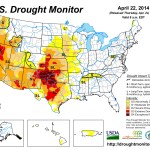
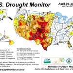
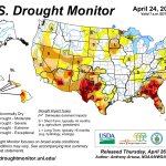
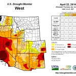
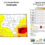
Click on a thumbnail graphic for a gallery of US Drought Monitor maps for late April for the past three years.
Click here to read the newsletter. Here’s an excerpt:
While the 2014 water year is a bountiful one in most of Colorado and portends a 110 percent of average runoff into Lake Powell, Colorado and its sister Colorado River Basin states are continuing with contingency planning to address plunging levels at Powell and Lake Mead.
Long-term drought and overuse of the river by the Lower Basin states of California, Arizona and Nevada, coupled with low flows, are threatening to take Lake Mead below the drinking water intake pipes for the Las Vegas area and drop Lake Powell below the levels where the turbines in Glen Canyon Dam can generate power.
Both possibilities would be disastrous. This is viewed as an operational emergency, not a compact issue, but it puts into play the planning and collaboration necessary for either across the seven-state region.
Here’s the pitch from the National Hydropower Asset Assessment Program:
The New Stream-reach Development Resource Assessment (NSD) project uses an innovative geographic approach to analyze the potential for new hydropower development in US stream segments that do not currently have hydroelectric facilities. NSD is one among other types of untapped hydropower potential such as non-powered dams, existing hydropower facilities, pumped storage, and small conduits. The NSD project considers “new stream-reach development” (assessments conducted for the conterminous US) and “new site development” (assessments conducted for Alaska and Hawaii) distinct from other hydropower resource classes identified by the US Department of Energy (DOE) Water Power Program.
Developed and implemented by Oak Ridge National Laboratory (ORNL) for the DOE Water Power Program, the assessments leverage recent advancements in various geographic datasets on topography, hydrology, and environmental characteristics to develop the highest resolution and most rigorous national evaluation of US hydropower potential to date. NSD assessments are not intended to determine economic feasibility or to justify financial investments in individual site development. The NSD project does, however, identify high-energy intensity stream-reaches and classify new potential areas for hydropower development using a range of technical, socio-economic, and environmental characteristics. The primary goal of this initiative is to produce and disseminate information and data that are applicable to multiple types of assessments, scenarios, and assumptions, ultimately leading to improved decision making and strategic planning by various organizations and individuals.
From the Denver Business Journal (Neil Westergaard):
Colorado and other western states are being positioned as ground zero in what appears to be a potential massive new push by the federal government to develop new hydroelectric power capacity in the U.S. That’s the underlying assumption in a new study unveiled by the U.S. Department of Energy Tuesday in Washington before a conference of hydroelectric-power interests.</p
Entitled “New Stream-reach Development Resource Assessment,” the report ( access here), by the Energy Department’s Oak Ridge National Laboratory in Tennessee, estimates that 65 gigawatts of additional hydropower could be developed nationwide — 3.8 gigawatts in Colorado…
But release of the report had environmental groups in Colorado and nationally saying, “Not so fast.”
It would take a massive infrastructure investment to achieve that kind of capacity. One Colorado River advocate said the kind of development suggested by the DOE’s numbers would mean “the end of rivers” in the state.
In Colorado, 3.8 gigawatts of hydro nearly approaches all of the existing hydroelectric power being generated in the entire Colorado River basin, including Hoover Dam, Glen Canyon Dam, Flaming Gorge and the Aspinall Unit dams on the Gunnison River.
Energy Secretary Ernest Moniz unveiled the study at the National Hydropower Association’s annual conference, meeting in Washington, D.C., this week. Moniz implored industry leaders to get behind the idea.
“Hydropower can double its contributions by the year 2030. We have to pick up the covers off of this hidden renewable that’s right in front of our eyes and continues to have significant potential.”[…]
In a press release, the DOE seemed to suggest that retrofitting existing non-powered dams would be one way expand hydroelectric capacity.
But Matt Rice, director of the Colorado River Basin Program of American Rivers, a Washington-based advocacy group, said the suggestion by DOE that 65 gigawatts of additional power could be generated this way ignores myriad legal, environmental and financial barriers.
“I think it’s a shame. It’s an irresponsible release with those numbers. It’s a shame because there’s a lot of great hydropower going on in Colorado,” Rice said. “To get to this number, you would need new dams, you would need new diversions, and that’s not to mention the legal barriers that would stop this kind of development.”
American Rivers isn’t opposed to hydroelectric power development. It sponsors programs to develop small retrofitted hydro units on existing un-powered dams and assists farmers and ranchers with development of small-scale hydro projects.
The DOE touted the study as a “New Vision for United States Hydropower” and established a website with a video on the benefits of hydropower. You can access it here.
Summitville Mine superfund site From the National Journal (Jason Plautz):
Environmental Protection Agency Administrator Gina McCarthy fired back in the war over her agency’s science, slamming critics who “manufacture uncertainties that stop us from taking urgently needed climate action.”
The agency’s scientific studies have become an increasingly convenient target for industry groups and congressional Republicans bent on stopping EPA regulations. Republicans have subpoenaed several health studies that EPA relies on for its air-pollution rules, and increasing attention has been heaped on the agency’s scientific review panels.
Speaking at the annual meeting of the National Academy of Sciences on Monday, McCarthy went after the “small but vocal group of critics” who she said were more interested in “looking to cloud the science with uncertainty … to keep EPA from doing the very job that Congress gave us to do.”
McCarthy also touched on the agency’s controversial use of human testing to measure the impact of air pollution, the subject of a recent Inspector General report that largely said the agency followed proper procedure. Critics have said that the human tests put the subjects at risk.
In her speech, McCarthy countered that the human tests helped scientists to “better understand biological responses to different levels of air pollutants.”
“Science is real and verifiable,” she said. “With the health of our families and our futures at stake, the American people expect us to act on the facts, not spend precious time and taxpayer money refuting manufactured uncertainties.”
Cache la Poudre River Click here to read the newsletter. Here’s an excerpt:
JOHN STOKES TO RECEIVE ANNUAL CWT AWARD
David Getches helped found the Colorado Water Trust and served on CWT’s Board of Directors for a decade until his passing in July 2011. The David Getches Flowing Waters Award is presented in honor of David Getches’ inspirational, collaborative, and innovative spirit and determination in restoring and protecting healthy Colorado streamflows.
Help us celebrate John Stokes, this year’s recipient of the David Getches Flowing Waters Award. John has a broad and long-term view of how to improve the health and beauty of the Cache la Poudre River. He understands that water users, diverters, recreationalists, and environmentalists must work together and understand their common interest in the long-term health of the river. John brings this perspective to the many stakeholders he works with and challenges them to broaden their views of how the community uses, cares for, and improves the Poudre. Please join us in cheering John Stokes’ contributions and achievements at RiverBank on Tuesday, June 3.
In an effort to improve the aquatic environment of the Roaring Fork River as it flows through central Aspen, the city of Aspen has agreed to leave 2 to 3 cubic feet per second (cfs) of water in the river during low-flow periods this summer instead of diverting it into the Wheeler Ditch.
The Wheeler Ditch diverts water from the Fork a short distance downstream from the Aspen Club pedestrian bridge and just below Ute Park, east of Aspen. The headgate for the irrigation ditch is on the left side of the river, when looking downstream, and is visible from the upper end of the city’s Wheeler Ditch Trail.
The water in the ditch is typically used to supply small channels in the downtown pedestrian malls, to irrigate some city property, and to keep a base flow running through the city’s stormwater system.
The Aspen city council on Monday approved an agreement with the nonprofit Colorado Water Trust to leave the water in the river when river flows drop below 32 cfs, the amount identified by the state as necessary to protect the river’s environment “to a reasonable degree.”[…]
It’s the second year the city has entered into such an agreement with the Water Trust, which works to bolster flows in rivers across the state.
Last year the city announced that it would leave between 6 and 8 cfs of water in the river, but experience showed that it was more practical to leave 2 to 3 cfs, according David Hornbacher, the director of utilities and environmental initiatives for the city.
The city owns an 1889 senior water right to divert up to 10 cfs from the Fork into the Wheeler Ditch.
The agreement with the Water Trust says the city will begin bypassing water from the Wheeler Ditch when the river drops below 32 cfs. If the river drops to 31 cfs, the city will bypass 1 cfs, and so on, until the point when there is at least one cfs left in the ditch…
“The Water Trust brings structure to the effort,” Hornbacher said. “They bring resources. And they provide a framework to work toward other future agreements to benefit the river.”[…]
This year, Twin Lakes expects to divert about 55,000 acre-feet of water from the headwaters of the Roaring Fork.
Further downstream and just east of Aspen, the Salvation Ditch in mid-to-late summer often diverts more water than is left in the river below the ditch’s diversion structure…
The Salvation Ditch, which has a water right from 1902 to divert 58 cfs, was diverting 17.4 cfs that day, leaving 7.6 cfs of water flowing in the Fork.
Another 2.4 cfs was then diverted into the Wheeler Ditch that day, leaving just 5.2 cfs flowing in the river as it made its way past Rio Grande Park, the Aspen Art Museum, and under the Mill Street Bridge.
That’s a far cry from the 32 cfs the state says is required to protect the river’s aquatic environment, and the city’s effort this summer is intended to help close such gaps.
“I appreciate the city’s leadership, as it can help start the conversation,” said [Amy Beatie] of the Water Trust. “We would love everyone to really sit down and think about what they have and how they could use it strategically to put water back in the river.”
More Roaring Fork River watershed coverage here and here.
[Winter Park Resort’s] snow total for the entire season stands at 376 inches – more than 31 feet – the most since 2011, according to Steve Hurlbert, Winter Park’s Director of Public Relations and Communications. “We were 28 inches ahead of our historical average of 348 inches, which dates back to when snow records began being kept in 1976. In March, we had 61.5 inches and April finished strong with 37.5 inches, which is almost exactly average (for April).”
Snow has started melting, but water officials still expect a banner spring runoff.
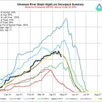
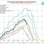
“We’re running water through the Boustead Tunnel, and the native flows in the Arkansas River basin have picked up,” said Roy Vaughan, manager of the Fryingpan-Arkansas Project for the Bureau of Reclamation.
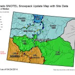
Snowpack in Colorado dropped to 102 percent of median this week after temperatures rose last week, but peak levels still finished above average.
“The normal peak is April 10, and we were well above average at that time,” Vaughan said. “The Snotel sites can be misleading, because a lot of that snow stays deep in the canyons.”
Nevertheless, runoff is occurring sooner than usual. So far, the Fry-Ark Project has moved 900 acre-feet of a projected 73,800 acre-feet from the Fryingpan River basin to the Arkansas basin.
“In 2009, we had moved 700 acre-feet by this time. It’s to be expected in a big year,” Vaughan said.
Typically, the heaviest flows in the tunnel will continue through June, and more can come through from summer rains or late runoff. The projection of 73,800 acre-feet for the Fry-Ark project was made April 1 and assumed normal precipitation on top of the already abundant snowpack. Since then, there have been several storms over the area. A new forecast will be made this week. Average Fry-Ark imports are about 54,000 acre-feet. Last year, about 47,000 acre-feet were brought into the basin.
With warmer temperatures Arkansas River flows increased last week to nearly double the previous flows. About one-sixth of the flows upstream from Lake Pueblo is water being released by Reclamation to make room for this year’s imports.
The new north outlet works at Pueblo Dam — Photo/MWH Global
From the Colorado Springs Business Journal (Marija B. Vader):
Wayne Vanderschuere, general manager of the Colorado Springs Utilities water services division, said the Southern Delivery System will be completed on schedule and $150 million under the original budgeted amount.
More Southern Delivery System coverage here and here.
Metropolitan Wastewater Reclamation District Hite plant outfall via South Platte Coalition for Urban River Evaluation
From the Colorado Springs Business Journal (Marija B. Vader):
Colorado Springs Utilities, along with Denver Water and the city of Aurora, all reuse a significant amount of water after it has gone through a treatment plant. It’s called non-potable water and as such is not acceptable for public consumption, cooking or bathing.
The wastewater system collects all the water from homes and businesses, then treats it to conditions set by the state health department. In most treatment centers throughout the state, the treated, non-potable water is then released back to the river or source whence it came. In Colorado Springs, Denver and Aurora, that water is recaptured and reused to water golf courses, public parks, cemeteries and the like. The systems do not extend to residential uses.
“The cost is extremely prohibitive to build such a system,” said Steve Berry of CSU. “Most customers would not tolerate the rate impact.” A system would cost in the hundreds of millions of dollars, he added…
The non-potable system in Colorado Springs provides a capacity of 13 million gallons a day during the summer. The Colorado Springs system has 26 miles of distribution pipelines that stretch to Bear Creek Regional Park, Kissing Camels Golf Course, Patty Jewett Golf Course, the U.S. Olympic Training Center, Peak Vista Community Health Centers, El Paso County, Memorial Park, Evergreen Cemetery, Colorado College, Valley Hi Golf Course and others. This program was put together beginning in 1961. Utilities’ charge for non-potable water is significantly less than for treated water.
Aurora’s non-potable system is used to irrigate parks, said Greg Baker, manager of public relations for the Aurora Water Department.
“It’s 5 million gallons a day we can save from potable use,” Baker said. The city’s irrigation season stretches from May 1 through Oct. 30.
“It makes perfect sense,” Baker said. “We don’t always want to apply potable water for irrigation.”
Denver’s non-potable system has a current capacity of 30 million gallons a day, expandable to 45 million gallons a day. The distribution system includes more than 50 miles of pipe with two major pump stations and storage tanks, according to Denver Water’s website. The system began operating in 2004, and when the recycled water system build-out is complete, Denver Water’s recycled supply will account for about 5 percent of the city’s total water volume annually, according to Travis Thompson, media coordinator for Denver Water.
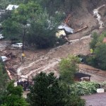
Longmont workers and residents have kept a closer eye on both Left Hand Creek and the St. Vrain River during the last week, when the annual spring runoff of mountain snowmelt began.
During a regular inspection for the water division, Longmont city workers spotted flood debris clogging a stretch of the creek near the 1300 block of Missouri Avenue. Such debris has been a special concern since a blocked channel could lead to more flooding…
In September’s flood, water from Left Hand Creek turned Missouri Avenue into a small river. The flooding left large amounts of mud in the nearby Southmoor Park neighborhood, but city officials and neighbors said afterward that damage would have been even worse without the flood-control improvements that the city made to the creek last summer.
Flows in Left Hand Creek were at 87 cubic feet per second Monday evening, according to online information from the Colorado Division of Water Resources. Levels in its parent stream, the St. Vrain River, were at about 350 cfs at midday — higher than average for the Longmont area at this time of year, according to public works director Dale Rademacher — but had fallen to 307 cfs Monday evening.
It seems like sneering at apple pie, motherhood, and blue skies. Why would you vote against water-efficient plumbing fixtures?
Nonetheless, S.B. 14-103 was approved by the Colorado Legislature with just one Republican vote. The bill would require that only those plumbing fixtures certified under the WaterSense program can be sold in Colorado as of Sept. 1, 2016.
A representative of Gov. John Hickenlooper said on April 25 that the governor plans to canvas water leaders around the state to understand the impacts to water use and conservation…
Denver Water, the primary proponent of the efficiency legislation, estimates that broad adoption of the water-efficient toilets, urinals, shower heads, and faucets will produce 40,000 acre-feet of savings across Colorado by 2050. The agency serves a quarter of residential customers in Colorado.
“Every conversation about water should start with conservation,” says Greg Fisher, manager of demand planning for Denver Water, parroting a line used by Hickenlooper (and probably many others).
Denver has significantly reduced per-capita consumption in the last 40 years. In the early 1980s, Denver Water coined the word “xeriscaping” to embody the idea of using plants and grasses native to the climate, to minimize the amount of outdoor irrigation at homes.
The drought of 2002 drove Denver to insist, not merely encourage, cutbacks to outdoor use. After the immediate threat ebbed, however, customers generally stuck with their new ways. Residential use in Denver and its service areas in close-in suburbs now averages 85 gallons per capita per day. That’s a 20 percent reduction since the start of the 21st century, but Denver hopes to squeeze another 2 percent of reduction in the next couple years.
Change-outs of indoor plumbing fixtures have helped shrink the per-capita use, says Fisher. Using rebates and assistance to low-income residents, Denver has retrofitted 135,000 toilets in its service area since 2003. The city’s WaterSense Challenge program also provides multifamily customers bulk discounts on toilets, faucet aerators, and showerheads. Field technicians in the agency’s commercial audits replace showerheads and faucet aerators free of charge.
While outdoor use is responsible for roughly three-quarters of residential water use, indoor plumbing changes can yield perhaps surprising savings…
At a House of Representatives committee hearing in March, Republicans questioned why Colorado needs a “one size fits all” approach to water efficiency. The general tone was that government had no right getting involved in people’s bathrooms. One of those committee members, Don Coram, a Republican from Montrose, later told a gathering in Durango that he opposed the bill because it wouldn’t save much water and it was impossible to enforce, according to a report in the Durango Herald.
Fisher had first taken the idea of water-efficiency standards to legislators two years ago, but admits now that he wasn’t ready to answer all the questions. This time, he says, he was ready, and his core argument was that more efficiency does not preclude consumer choices…
WaterSense-labeled toilets use 20 percent less water per flush but perform as well or better than today’s standard toilets and older toilets that use much more water.
Toilets once needed 7 gallons of water per flush. That dropped to 3.5 gallons and then, by 1996, 1.6 gallons. Now, all toilets certified by WaterSense use 1.28 gallons or less, with some models using as little as 0.8 gallons per flush.
WaterSense-certified bathroom faucets outfitted with aerators can save 30 percent.
Why mandate WaterSense fixtures? Building codes have begun requiring greater efficiency. And consumers at The Home Depot and other places are buying them on their own…
Fisher said Denver Water decided that mandates were needed to capture the entire market, retail and wholesale, and accelerate the pace of adoption.
“If we felt comfortable that the market was going to take care of this in the near future, I don’t think we would have seen the need for the bill,” says Fisher.
But he also said that Denver, in its strategies, wants to emphasize that lifestyles need not be sacrificed even as greater efficiencies are wrung out of water supplies…
This is just one of a trio of bills aimed at increasing water conservation and efficiency that were introduced in the Colorado Legislature this year. The most controversial was introduced by Sen. Ellen Roberts, the lone Republican to cross the partisan aisle to vote for the efficiency mandate. Based in Durango, she proposed strict limits on lawn sizes in any subdivision using new imports of water in cases where farms had been dried up for municipal supplies. The idea was sent to an interim summer committee for further consideration.
Yet another bill, introduced by Sen. Gail Schwartz, a Democrat from Snowmass Village, would have allowed legal transfer of water saved by farmers and ranchers through improved efficiencies. Under her original proposal in S.B. 14-023, the saved water could have been donated as dedicated instream-flow right in the rivers and creeks. It reportedly has run into opposition because of various concerns.
A plan to fund a study of either a dam or series of detention ponds on Fountain Creek is now in the hands of Colorado Springs City Council. Pueblo County commissioners Monday approved prepayment of $291,000 in interest payments by Colorado Springs Utilities to the Fountain Creek Watershed Flood Control and Greenway District. Part of that, about $60,000, would fund the next phase of a dam study on Fountain Creek. Last week, the district narrowed that effort to compare either a dam or series of detention ponds to reduce the impact of Fountain Creek floods on Pueblo. The money would be an advance payment on $50 million Utilities pledged to pay the district for Fountain Creek dam studies under its 1041 agreement with Pueblo County for its Southern Delivery System.
Colorado Springs already has prepaid $600,000 of that to the Fountain Creek district. If it agrees to pay another $291,000, Pueblo County will deduct that amount from the $50 million as well, under the resolution passed Monday.
“CSU staff was recommending not paying (the interest), because they said, ‘We don’t see what we’re getting,’ ” said Terry Hart, chairman of the commissioners. “We see an enormous benefit to the district in converting this drainage ditch into an amenity that everyone, including Colorado Springs, can enjoy.”
Utilities is controlled by the Colorado Springs City Council, however. Last week, Hart received assurances from Colorado Springs Councilman Val Snider that the payment would be examined.
“I’m astonished they have to ask what’s in it for them,” added Commissioner Liane “Buffie” McFadyen. “It’s imperative that they work with us.”
Utilities wanted to add language to the county’s resolution indicating it was in good standing when it came to the 1041 permit. The commissioners balked at that, and made it clear in the resolution that 1041 compliance is a separate issue. The board also put in a clause that requires the Fountain Creek District to provide an annual report of how the money is spent.
“Colorado Springs hasn’t always been a good neighbor to us,” said Commissioner Sal Pace. “I’m hopeful the $50 million will be enough to leverage hundreds of millions needed to build flood detention storage.”
Meanwhile Pueblo District Attorney Jeff Chostner is weighing his legal options in his water quality challenge to CSU’s 1041 permit from the county. Here’s a report from Chris Woodka writing for The Pueblo Chieftain:
Pueblo District Attorney Jeff Chostner is looking at legal options, including a possible federal lawsuit, after the state Supreme Court rejected his petition to reconsider water quality rulings for the Southern Delivery System. The Colorado Supreme Court Monday refused to reconsider an appeals court’s decision to overturn Pueblo District Judge Victor Reyes’ order for the Colorado Water Quality Control Commission to redo its assessment of SDS on Fountain Creek and the Arkansas River.
Chostner and the Rocky Mountain Environmental Labor Coalition wanted the high court to uphold Reyes’ 2012 ruling, which was reversed by a three-judge panel last July.
“I’m very disappointed in the outcome of the suit and we’re weighing our legal options,” Chostner said shortly after learning of the Supreme Court decision.
“Colorado Springs Utilities believed all along in the state’s approval of the SDS water quality certification and are pleased that today’s Supreme Court decision finally brings this issue to closure,” said John Fredell, SDS program director.
The original complaint was made by former DA Bill Thiebaut, and Reyes agreed with him that the state water quality board should have held Colorado Springs Utilities to a numerical standard, rather than relying on an adaptive management program.
The state ignored its own standards in approving a water quality certification for SDS, Reyes said.
Monday’s Supreme Court denial of the petition means the Colorado Court of Appeals July ruling stands and Colorado Springs Utilities can complete its work on the pipeline as planned.
“We believed all along in the state’s approval of the SDS water quality certification and are pleased that today’s Supreme Court decision finally brings this issue to closure,” said John Fredell, SDS program manager.
In July, the Colorado Court of Appeals said Colorado Springs Utilities had done all the necessary work to ensure that SDS would not wreck water quality in Fountain Creek. The court had reversed a Pueblo County judge’s ruling against a state water quality certification for Colorado Springs’ SDS pipeline project. The Water Quality Commission gave the SDS its stamp of approval after more than a year of study. The commission’s approval was challenged by former Pueblo District Attorney Bill Thiebaut and the Rocky Mountain Environment and Labor Coalition.
However, the appellate court cited a number of reports and analyses and found that all the proper tests were completed and that there was substantial evidence that showed SDS will not violate water quality standards in Fountain Creek.
In August, Chostner requested that the Colorado Supreme Court review the appeals court decision.
“Obviously I am very, very disappointed with it,” Chostner said of the Supreme Court denial. “We are taking a look at our legal options as to how we can respond to it.”
SDS has been embroiled in controversy, piles of federal, state and local regulations and litigation for years. The project was launched to bring more water to Colorado Springs, Fountain, Security Water District and Pueblo West for future population growth. The first stretch of pipe was built in 2010 and the pipeline is expected to be completed by 2016. Utilities officials say the estimated cost of the phase 1 of the project – 53 miles of pipeline, three pump stations and a new water treatment plant capable of delivering up to 50 million gallons of water per day – is $841 million, about $150 million less than projected.
From the Colorado Springs Independent (J. Adrian Stanley):
The Colorado Supreme Court denied an appeal today by the Pueblo County District Attorney that sought to derail Colorado Springs Utilities’ Southern Delivery System. The decision clears the last major potential roadblock for the $898 million pipeline from Pueblo Reservoir to Colorado Springs, which is already well under construction.
Pueblo County alleged that the state’s approval of permits for the project didn’t adequately consider water quality issues. Pueblo has long fought SDS, claiming that the return flow from the pipeline along Fountain Creek will exacerbate stormwater and water quality issues.
This week marked the five year anniversary of when the U.S. Department of Energy began the $1 billion cleanup of the 16 million tons of tailings left over a legacy of uranium mining at the now defunct Atlas Mill.
The 130-acre site was leaching uranium and hazardous chemicals into the Colorado River, spurring contamination concerns for 30 million downstream users.
In 2009, an infusion of $108 million in federal stimulus money fast-tracked the project, accelerating the removal of the tailings to a disposal site 30 miles away at Crescent Junction.
“It is slowly getting there,” said project manager Don Metzler. “It is on track and we feel good about that.”
Metzler, whose supervision of the Moab Uranium Mill Tailings Remedial Action garnered national recognition in 2011, said the massive cleanup effort is now 42 percent complete.
“We have moved 6.7 million tons of the 16 million tons,” he said. “We still have a lot to go.”
The tailings are scooped and loaded into the beds of huge dump trucks and then poured into rail cars. A train leaves the site once a day, four days a week, traveling north to a specially-engineered disposal site at Crescent Junction.
Metzler said the annual funding of $35 million received a boost to $38 million, and the additional money will be used to further cover a section of the disposal cell.
“We do this in sequential steps. We are not going to wait until the entire project is over before we cover,” he said.
Clay and rock material has been put on 40 acres and another 10 acres or so will also receive a protective fill.
Metzler is also in the process of implementing a flood control plan.
With spring runoff in full swing, the Colorado River has risen 2 feet in the past few weeks, Metzler said, and it expected to crest its banks in another 30 to 40 days.
Protective berms have been engineered to keep the river water away from the radioactive dirt, he added, and the project will be doing community outreach to keep residents informed of flood threats.
From email from the Colorado Division of Water Resources (Kevin Rein):
During the 2013 legislative session, the General Assembly enacted HB-1248 to provide for fallowing-leasing pilot projects. At its November 2013 Board meeting, the CWCB approved Criteria and Guidelines for the pilot projects and in December, the CWCB received an application for selection and approval of a pilot project for the Town of Fowler. That application was subsequently withdrawn.
On June 5, 2014, CWCB staff will hold an informal workshop to review the Fowler Pilot Project and discuss the lessons learned through the application and review process. The CWCB’s objective is to apply lessons learned to any upcoming pilot project applications.
Fowler Pilot Project
Lessons Learned Workshop
June 5, 2014
9:00 am to Noon
1313 Sherman Street
Room 318
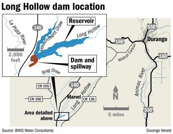
Construction of the dam designed to corral 5,100 acre feet of runoff from two modest streams in this arid section of La Plata County is expected to be completed in July – two years after groundbreaking. Long Hollow Reservoir will be a water bank against which irrigators in the area can draw. They will be able to pull more water from the La Plata River, which must be shared with New Mexico because the reservoir can make up the difference…
Brice Lee, president of the sponsoring La Plata Water Conservancy District, said the district has been pursuing the Long Hollow project since the 1990s when the irrigation-water component was removed from the larger and seemingly interminable Animas-La Plata Project, known as A-LP…
Potentially, 500 to 600 irrigators could be interested in reservoir water, he said. A fixed fee would be set to cover maintenance and operations, plus a charge based on consumption. Irrigators who don’t go for the backup source of water will continue to take their chances with the fickle La Plata River.
The reservoir will store water from Long Hollow Creek and Government Draw, which drain 43 square miles east of Colorado Highway 140. The reservoir is about five miles north of the New Mexico line and a half-mile from the confluence of Long Hollow Creek and the La Plata River.
An outlet on the left side of the dam feeds the natural channel of Long Hollow Creek below the dam, a U.S. Fish & Wildlife Service requirement aimed at maintaining aquatic life.
Water also can be diverted into a high-flow pipeline if water demands from New Mexico exceed 10 to 12 cubic feet per second or if an emergency release were required.
It was first estimated that the project would cost $22.5 million. The pot consisted of $15 million set aside by the Colorado Water Resources and Power Development Authority for future projects when the A-LP was downsized. Accrued interest and $3 million from the Ute Mountain Ute Tribe completed the budget. But a bill making its way through the state Legislature is expected to contribute an additional $1.575 million to cover the expense of meeting unexpected difficulty in readying the dam’s bedrock foundation for construction.
The dam is 151 feet high with a span of 800 feet. A central clay core is buttressed upstream and downstream by tons of sand, dirt and rock. Construction, which began in July 2012 with excavation down to bedrock, was followed by filling with grout under pressure fissures in the bottom and embankments of the dam to prevent leaking. Some grout holes were bored as deep as 120 feet. All construction material, with the exception of steel and concrete, come from on-site sources.
The capricious flow of the La Plata River has produced verbal shoving matches between Colorado and New Mexico since the signing in 1922 of the compact that requires the states to share the river. Each state has unrestricted use of the water from Dec. 1 to Feb. 15. But from then until Dec. 1, if the river is flowing at less than 100 cubic feet per second at the state line, Colorado must deliver one-half the flow at Hesperus to New Mexico. Living up to the terms of the agreement isn’t easy.
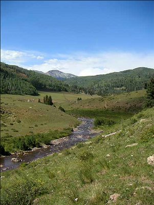
The La Plata River, which tumbles from its origin high in the mountains north of U.S. Highway 160, isn’t the most generous of sources at best. A porous river bed and thick vegetation grab an inordinate share of the flow. The growing season is longer than the period of river flow…
The dam was designed by GEI Consultants, a national firm with a branch in Denver. The Weeminuche Construction Authority is the builder. Among the 50 crew members, 80 percent are Native American, with 65 percent being Ute Mountain Utes, said Aaron Chubbuck, the Weeminuche project manager.
The construction engineer, hired by the water district, is Rick Ehat, who brought the A-LP to completion on time and on budget after an earlier administration fell disastrously behind on both counts.
The finished dam may appear a monolithic structure. But it’s actually an amalgamation of “zones” comprised of dirt, rock, sand and clay with each ingredient serving a certain purpose.
After the topping-out ceremony marks the completion of construction, the “borrow areas” where construction materials were taken will have to be revegetated. Also, certain electrical and mechanical work remains to be done. Among the tasks, sensors will be installed on the downstream face of the dam to measure possible movement or leakage…
Unlike the Lake Nighthorse, the A-LP reservoir, which was filled by pumping water from the Animas River, Long Hollow Reservoir will depend on precipitation runoff and return flow from agricultural operations.
The construction used 900,000 cubic yards of material, compared with 5.4 million cubic yards for Ridges Basin.
While useful for its purpose, the 5,100 acre-feet of water behind Long Hollow dam is peanuts compared to the 123,541 acre-feet in Lake Nighthorse and the 125,000 acre-feet in Vallecito Reservoir.
Depending on the weather, Ehat said, it could take five to seven years for the reservoir to fill from runoff from Long Hollow Creek and Government Draw.
Without a doubt, the Valley’s six governments are against the potential Rio Grande Cutthroat (RGCT) endangered species listing. The San Luis Valley County Commissioners Association (VCC) unanimously decided Monday to add its organizational name to a Memorandum of Understanding (MOU) between 10 county governments stating there is no need to list the species.
In addition to the six Valley counties – Alamosa, Conejos, Costilla, Mineral, Rio Grande and Saguache – Hinsdale, Las Animas, San Juan and Archuleta Counties also have a signatory line on the MOU. To date, Rio Grande, Conejos, Mineral, Saguache and Hinsdale have already made the commitment on paper.
The U.S. Fish and Wildlife Service (FWS) continues to find listing the RGCT warranted but precluded, according to the Federal Register , Fri. Nov. 22, 2013. The agency, however, is working on a proposed listing rule expected to publish soon.
“The deadline has come and gone,” said Tom Spezze, who is heading up the local RGCT listing fight. The delay, he said, is “good news for us” because having the MOU in place prior to the decision shows a “stronger level of commitment” and allows the VCC to use its “political horsepower.”
The ruling, an initial recommendation on whether the Valley’s historical breed of fish , which is also found in New Mexico, will classify the species as endangered, threatened or not warranted for listing.
Spezze and Hinsdale County, whose government is acting as the campaign’s fiscal agent, also asked each county to contribute some funding to the effort. According to Hinsdale County Commissioner Cindy Dozier, about $23,000 – roughly $3,000 from each county – is needed for both Spezze’s work and legal counsel.
“We did this (became the fiscal agent) in good faith because we believe all the counties will get on board,” Dozier said.
Before the counties offer up any money, a financial subcommittee will form and discuss contributions.
“We need to take this back to individual counties and see what our finances are,” said Alamosa County Commissioner Darius Allen.
His fellow commissioner Michel Yohn added, “This (the potential listing) does affect us tremendously. I see more costs coming. As counties, we need to realize this.”
The implications from an endangered or threatened listing for any species can vary from jeopardizing tourism dollars due to changes in the public’s access to public lands to land owners having to enter into agreements prioritizing the species existence , actual or potential.
“The RGCT are what we say they are,” Spezze said. “There is a 90 to 95-percent genetic confidence . There are no lineage crossovers.”
Listings also come along with the identification of critical habitat, which calls for special management and protection, and can include an area the species does not currently occupy, but will be needed for its recovery.
“There are impacts beyond the RGCT,” said Travis Smith, San Luis Valley Irrigation District manager and Colorado Water Conservation Board member. “We are in a place right now to send a strong message about a culture change. It transcends more than just fishing.”
Streams historically capable of supporting the RGCT that the FWS could deem critical habitat include Rio Grande, Pecos and Canadian River Basins, according to CPW data, and presently the fish only occupy about 11 percent of the historic waters. There are 127 RGCT conservation populations range wide, which includes the model efforts of the Trinchera Ranch to keep the species thriving in its creeks. Spezze added that should the RGCT make the endangered species list it is not foolish to think senior water rights could be affected in the future.
“We can’t just bury our heads in the sand,” said Rio Grande Commissioner Karla Shriver. “Every county should look at it seriously, and as a group we can do more. Maybe we can proactively stop this? We need to protect our constituents. We need to give them a voice.” For the past 40 years, the Valley has spent dollars state, federal and private to keep the RGCT alive and well for reasons spanning from recreation to genetic diversity protection, fending off a species status change on several occasions.
In 1973, the species was listed as a threatened species in Colorado, and removed in 1984. Fourteen years later, a federal petition was filed under the Endangered Species Act, and it was contested in court in 2002. In 2007, the RGCT was reviewed, and a year later the FWS found the listing was warranted, but precluded. Between 2003 and 2011, Colorado Parks and Wildlife (CPW) and the Rio Grande Cutthroat Trout Conservation Team expended $792,000 on RGCT conservation efforts , according to CPW data, including surveying RGCT populations, establishing conservation populations, erecting barriers preventing species contamination, stocking genetically pure RGCT populations and working with other agencies and groups to ensure there are sufficient instream flows to support native fish and their required habitat.
Paying past water debts while trying to keep up with current ones could be a make-or-break proposition for new water management sub-districts throughout the San Luis Valley. the Valley, members of the Rio Grande Water Conservation District (RGWCD) began developing an alternative several years ago that it hoped would allow Valley farmers to stay in business while complying with state regulations. The larger water district sponsored sub-districts for various geographical areas of the Valley, with the first lying in the closed basin area in the central part of the Valley. The sub-districts’ goals are to make up for depletions well users have caused in the past and are causing in the present , plus rebuild the Valley’s aquifers. One of their objectives is to take irrigated land out of production to reduce the draw on the aquifers.
The first sub-district is operational now with fees collected from farmers within the sub-district paying for water to offset the depletions and injuries to surface Background Knowing the state would soon be regulating the hundreds of irrigation wells in users caused by their well pumping. As the late RGWCD President Ray Wright described the effort, it was a “pay to play” proposition. For example, those who did not have surface water rights would pay more to continue operating their wells than those who had both surface and groundwater.
The first sub-district is also putting water in the river to replace injurious depletions its well users have caused to surface rights. One of the methods the sub-district has used to meet its goals is to purchase property. Another has been to support the Conservation Reserve Enhancement Program, which is included in the farm bill. That program pays folks to fallow land either permanently or for a specific time period, with cover crops planted for ground cover and erosion Sub-district #1 submitted its annual replacement plan to its board, its sponsoring district and the state engineer and court this week. The subdistrict board of managers and RGWCD board approved the plan, and RGWCD General Manager Steve Vandiver personally presented it to Colorado Division of Water Resources Division 3 Engineer Craig Cotten on Tuesday.
The 2012 annual replacement plan was challenged, with some of those legal challenges still pending in court. (The 2013 plan was not contested.) RGWCD Attorney David Robbins told the board on Tuesday the Colorado Supreme Court has not yet set the matter for arguments, and if it does not do so in the next week or two, it will probably not schedule the arguments until September or October. The local water court upheld the plan, but objectors appealed to the Supreme Court, which has received briefs from the parties in the case but has not yet set a time to hear arguments.
Robbins said there are three issues involved in the court case regarding the 2012 annual replacement plan: 1) use of Closed Basin Project water as replacement water, “that’s a good legal argument ;” 2) the way augmentation plans were accounted for in the 2012 replacement plan, “that’s a slap my hand argument;” and 3) when the annual replacement plan becomes effective, a procedural argument. Current activity
Now that the first subdistrict is operational and the state’s groundwater rules likely to be filed in the next month or two, the sponsoring water district is fervently assisting sub-district working groups from Saguache to Conejos and everywhere in between. One of the proposed sub-districts , for example, lies along the alluvium of the Rio Grande.
RGWCD Program Managers Rob Phillips and Cleave Simpson are working to get the new sub-districts formed.
Vandiver told the RGWCD board on Tuesday that Simpson is working hard with working groups for Subdistricts #2, 3, and 4 to get petitions ready to be signed by landowners in those subdistricts and to draft a plan of management and budget for each sub-district . Those will be presented to the water court when they are completed. Simpson told the RGWCD board on Tuesday all three of those sub-district working groups plan to present their completed petitions to the sponsoring water district board before the end of this calendar year.
Vandiver added that Subdistricts #5 and 6, Saguache Creek and San Luis Creek, are not as far along. The Saguache Creek group has held numerous meetings but is waiting on final numbers from the state’s groundwater model to know how much it will owe in depletions before it can proceed much further. The working group for the San Luis Creek sub-district fell apart, Vandiver said, but a few well owners in that area are getting back together and will meet next week for the first time in a long time.
Vandiver also told the RGWCD board on Tuesday that a group of federal and state agencies that own wells in the Valley are meeting to discuss their options. They will also have to comply with the groundwater regulations, as will municipalities with wells. Vandiver said state, federal and local agencies/ municipalities will have to join/form a sub-district or create augmentation plans to comply with the pending state rules. Many of the agencies are interested in joining subdistricts , he added. In doing so, they would either have to pay with cash or water, and many of them have water they could contribute, which would be helpful for the subdistricts . Water debt challenges RGWCD Director Cory Off brought up the issue of the district having to provide a guaranty to the state for lag depletions from past pumping , which was determined in the case of Sub-district #1 to be 19 years. Off said District Judge O. John Kuenhold in 2008 ruled the sub-district had to pay lag depletions to the river but did not say the sub-district had to provide a guaranty. The first plan of water management, which the state engineer approved, required the sub-district to have two years of wet water in storage, Off added.
The state engineer did not say anything about a guaranty in 2011, but in 2012 the state required the district to sign a letter of guaranty, which it did, Off added. He said he believed the water district board needed to rethink this matter because he did not believe the district had an obligation to file a guaranty, particularly for Sub-district #1 since it had already been approved by the court, or any future sub-districts. By signing the letter of guaranty for Subdistrict #1 the district was putting future sub-districts in a precarious position, he said, because subsequent sub-districts do not have the economic ability to cover lag depletions like Sub-district #1 does. Off said the first sub-district is comprised of a large number of farmers, but some of the other sub-districts have a fraction of the populace but even greater depletions to make up.
RGWCD Director Lawrence Gallegos said that was true of the two sub-districts in Conejos County, and if those sub-districts had to provide a guaranty for lag depletions, their fees would be astronomical.
“I think it could be make-it or break-it especially for the two sub-districts that are in the county I represent,” he said. “I think we need to have the sub-districts working ” We don’t want to set anybody up to fail.”
He said the RGWCD board needs to ask its legal counsel to talk to the state engineer about other arrangements that wouldn’t break the subdistricts .
RGWCD Director Dwight Martin said Sub-district #4, with which he has been involved, has been trying to determine what its obligation will be. It does not have firm numbers yet. Martin said if the depletions are 22,000 acre feet, it is going to be extremely difficult if not impossible to meet that obligation. If the depletion repayment is 8,000 acre feet, the sub-district can put together a workable budget with the approximately 400 wells involved in that sub-district .
Robbins said Sub-district #1 is close to having enough water or cash to pay its lag depletions if it went out of business today, and each area of the Valley where depletions have occurred must make up for its depletions either cooperatively through sub-districts or individually through augmentation plans. He said the district does not yet know what the lag depletions will be for the rest of the sub-districts because they are hydrologically different than Sub-district # 1. For example, Sub-district #2 is right along the river.
“The state engineer cannot approve a plan of management unless he’s given assurance the depletions that are caused by the pumping will be replaced so that there is no injury to senior water rights,” Robbins said.
Cotten agreed. He said it is like getting a 20-year loan. If someone told the bank he would pay the first year but provided no guaranty he would pay the next 19 years, he would probably not get the loan. He added that this is not the only basin where the state engineer has required this type of thing.
Off said he was not saying the depletions should not be replaced.
“Paying depletions to the river obviously has to happen ,” he said.
His problem was with the guaranty for lag depletions, he said.
Robbins said there might be several ways those lag depletions could be covered . It could be through a permanent forbearance, for example, he said.
“There are a lots of ways to solve the problem other than simply putting money in escrow,” Robbins said.
RGWCD President Greg Higel said as a senior water owner he wanted to see lag depletions paid back and wanted to see some sort of guaranty in place that they would be.
Vandiver said the state engineer’s responsibility is to protect the surface water users that the sub-district plan was designed to protect. He said the senior/surface water users drove the point home to the court and the state that replacement of depletions was a critical issue that must be addressed. “The objectors from the very beginning have said it wasn’t enough, it just wasn’t enough.”
Vandiver said he was not opposed to going back to the state engineer to talk about lag depletions, but he believed the district must present some options.
Robbins said, “If the board wants me to talk to the state engineer, we can come up with the options.”
He added he was not opposed to having a preliminary discussion with State Engineer Dick Wolfe to see how much flexibility he might be willing to provide.
The RGWCD board unanimously voted to have Robbins speak with the state engineer about the lag depletion guaranties and alternatives.
Here’s the release from the US Army Corps of Engineers (Rena Brand/Eileen Williamson):
The Final Environmental Impact Statement (EIS) for Denver Water’s Moffat Collection System Project is available for public review. The Colorado Front Range water supply project proposes to enlarge the existing Gross Reservoir in Boulder County, using existing infrastructure to divert water from the Fraser River, Williams Fork River, Blue River and South Platte River to Denver’s existing water treatment system during average and wet years.
The purpose of the Final EIS is to provide decision-makers and the public with information pertaining to the proposed project and alternatives, and to disclose impacts and identify mitigation measures to reduce impacts. The Corps is charged with the responsibility of impartially reviewing Denver Water’s proposal in light of environmental and other Federal laws.
In 2009, a Draft EIS was released by the Corps, public hearings were held and thousands of comments were received. The Final EIS was updated in response to comments received on the Draft EIS. The comments and the Corps’ responses to these comments are included in Appendix N of the Final EIS.
The Final EIS will serve as a basis for the Corps’ decision on whether to issue or deny a Section 404 Permit for the enlargement of Gross Reservoir. The Corps’ decision will be in the form of a record of decision, which will conclude the National Environmental Policy Act evaluation process. The record of decision will not be issued for several months.
The public is encouraged to review the Final EIS during an open comment period from April 25, 2014 to June 9, 2014.
The Final EIS is available online for viewing or download at:
available for viewing at the following Colorado locations:
Grand County
Fraser Valley Library, 421 Norgren Road, Fraser, CO 80442
Granby Library, 55 Zero Street, Granby, CO 80446
Kremmling Library, 300 South 8th Street, Kremmling, CO 80459
Adams County
Anythink York Street Library, 8990 York Street, Thornton, CO 80229
Denver County
Denver Central Library, 10 West 14th Avenue Parkway, Denver, CO 80204
Boulder County
Boulder Main Library, 1001 Arapahoe Avenue, Boulder, CO 80302
Jefferson County
Arvada Library, 7525 West 57th Avenue, Arvada, CO 80002
Golden Library, 1019 10th Street, Golden, CO 80401
Summit County
Summit County Library North Branch, 651 Center Circle, Silverthorne, CO 80498
Summit County Library South Branch, 504 Airport Road, Breckenridge, CO 80424
Denver Water
1600 West 12th Avenue, Denver, CO 80204
U.S. Army Corps of Engineers
Omaha District, Denver Regulatory Office, 9307 South Wadsworth Boulevard, Littleton, CO 80128
Written comments should be sent to: U.S. Army Corps of Engineers, Omaha District, Denver Regulatory Office, Attention: Rena Brand, Moffat EIS Project Manager; 9307 S. Wadsworth Blvd, Littleton, CO 80128. Comments can also be emailed to: moffat.eis@usace.army.mil. Comments must be postmarked or received no later than June 9, 2014.
Trout Unlimited today responded to the release http://cdm16021.contentdm.oclc.org/cdm/ref/collection/p16021coll7/id/720 of the Final EIS for Denver Water’s Moffat Collection System project, calling on the U.S. Army Corps of Engineers to incorporate into the final permit the provisions of an agreement on Fraser River protections forged by Trout Unlimited, Denver Water and Grand County.
“Trout Unlimited will be reviewing the Final Environmental Impact Statement closely and cannot yet comment on its contents, but in light of the potential impacts we know an unmitigated Moffat Project creates in the Fraser River basin-including loss of an outstanding wild trout fishery-we call on the Corps to recognize the impacts and incorporate into permits the mitigation and enhancement commitments agreed upon by Denver Water, Grand County, and Trout Unlimited and announced http://www.tu.org/press-releases/denver-water-tu-reach-agreement-on-river-protections-for-fraser in March 2014,” said David Nickum, executive director of Colorado Trout Unlimited.
Denver Water’s 2011 Cooperative Agreement with West Slope water users was a great step forward in addressing current impacts on the Fraser caused by diversions-but as TU, Grand County officials and others noted
at the time, the agreement did not address the future impacts of the Moffat expansion on the Fraser.
* Water is made available to address elevated stream temperatures on the Fraser and Ranch Creek.
* Denver uses its operating flexibility to provide flushing flows to cleanse streams.
* Ongoing monitoring of stream health, and adaptive management using water and financial resources provided by Denver Water – and leveraged by other partners.
* Commitment to this monitoring and management program-called “Learning by Doing”-through the project’s federal permit.
“The Fraser watershed has been a system in decline, and it won’t be protected by simply blocking the Moffat Firming Project and walking away,” said Nickum. “Trout Unlimited realized that protecting this river was going to require a new way of doing business, a collaboration among those who influence and rely upon the Fraser so that everyone has a shared stake in conserving the river for the long term. That is the idea behind the Learning by Doing program.”
“There is no question that the Moffat Project, unmitigated, will further impact an already-depleted watershed,” said Mely Whiting, TU’s Colorado Water Project Counsel. “This is why Grand County, Denver Water, and Trout Unlimited worked in good faith to develop a mitigation and enhancement plan that addresses the impacts and puts the Fraser River back on a path toward a healthy future. We now need the Corps to ensure that those protections are fully incorporated into project permits.
“We look forward to reviewing the Final EIS carefully and working with the Corps, Grand County, and Denver Water to ensure that the responsible protections we have proposed become part of the final project mitigation package.”
“The Fraser is the lifeblood of our community and a vital part of our natural and cultural heritage,” said Kirk Klancke, president of TU’s Colorado River Headwaters chapter in Fraser and a longtime advocate for the river. “Now it is time for the Corps to step up and make sure that the waters that once drew President Eisenhower to our valley are protected for future generations.”
Colorado River Basin in Colorado via the Colorado Geological Survey
From email from Reclamation (Kara Lamb):
Work at Green Mountain Dam has wrapped up and it is time to start increasing releases again. Here is the schedule for bumping up over the weekend and Monday. By Monday afternoon, we should be releasing about 900 cfs to the Lower Blue River.
Saturday, April 26, 2014
5:00 p.m. – Increase the reservoir release from 550 cfs to 600 cfs.
10:00 p.m. – Increase the reservoir release from 600 cfs to 650 cfs.
Sunday, April 27, 2014
5:00 p.m – Increase the reservoir release from 650 cfs to 700 cfs.
10:00 p.m. – Increase the reservoir release from 700 cfs to 750 cfs.
Monday, April 28, 2014
7:00 a.m. – Increase the reservoir release from 750 cfs to 800 cfs.
11:00 .m. – Increase the reservoir release from 800 cfs to 850 cfs.
4:00 p.m. – Increase the reservoir release from 850 cfs to 900 cfs.
Swollen streams are running faster than normal in northern Colorado while an enormous snowpack begins to melt in the mountains above. With reservoirs too full to help absorb the expected rush, municipal, county and state crews are scrambling to strengthen improvements in the same areas wrecked by last fall’s flooding.
A snowpack that the National Weather Service ranks among the highest in the past 35 years is poised to melt and cause flooding in normal conditions. Instead, snowmelt will rake across a landscape left fragile by September’s historic floods.
Crews hope spring flooding doesn’t endanger the millions of dollars in repairs that already have been made.
Whether the crews have done enough in time is a question that can be answered only by Mother Nature.
“Nobody is quite sure how things are going to respond,” said Bill McCormick, Colorado’s chief of dam safety.
September’s floods plowed through this region, obliterating the stream banks, dams and ditches that help funnel water from the mountains to the plains. In Larimer County, the flood damaged or destroyed 65 culverts and bridges.
Still about three weeks from the typical peak of the northern Colorado snowmelt, creeks and rivers are already being tested.
“There’s more water running in the streams this year than I’ve seen in 35 years of doing this,” said Randy Gustafson, water resource administrator for Greeley who has worked his entire career at the filter plant that the city operates in Bellvue at the mouth of Poudre Canyon.
Wednesday morning, he and Kallie Bauer, a state dam-safety engineer, inspected and gave the A-OK to the Milton Seaman Reservoir. The dam there is continuously rated “high risk” because if it fails, “people in Fort Collins will die,” Gustafson said.
The dam, however, survived last fall’s flood in good shape and is capable of handling much more than even that historic flood, Bauer said.
Historic snowmelt
How high the water rises depends partly on how warm the temperature gets at higher elevations, where the snow awaits. Areas above the flood zones have a snowpack of about 150 percent of its 30-year average, and some areas are closer to 250 percent, according to water managers.
The agency already is telling people in Jefferson, Boulder and Larimer counties to brace for flooding.
Complicating matters, reservoirs that normally empty out in the fall and make room for the snowmelt in the spring refilled in September, McCormick said.
Water storage statewide was already at 89 percent of average at the end of March, when only a fraction of the snowpack had melted, according to the Colorado Water Conservation Board. In other words, reservoirs will provide little or no harbor for the massive snowmelt still to come. The rest will travel downriver.
“They’re going to spill a lot sooner this year, there’s no doubt about that,” McCormick said.
Residents in the area hit hardest last fall are worried about any level of flooding and the further damage it could do.
“I don’t even want to think about the creek rising,” said Ben Huff, whose home near the Big Thompson River outside Drake is one of the few that can still be inhabited after the last flood. “And the ground under our house is so soft; I don’t want any more water underneath it, or it might slip on down the hill.
Under threat
The recurrence of washed-out canyon roads is a disaster the Colorado Department of Transportation is hurriedly trying to avert this spring. The highway department made emergency repairs to reopen major roads last fall, but the fixes were temporary. The plan was to make more durable repairs when the weather improved in the spring.
The work to fix the problems that ruined the fall-tourism season is now complicating travel in the spring.
On Wednesday — a sunny, dry afternoon — the 20-mile drive on U.S. 36 from Estes Park to Lyons took more than an hour. The route narrowed to one lane of bumpy, dusty dirt road in several locations, and 10- to 20-minute stops were common, as road crews and heavy equipment worked nearby.
“We’re kind of in a race against time to beat the snowmelt,” said CDOT spokeswoman Amy Ford. “We’re certainly hoping (flooding will be manageable), but we can’t leave that to chance.”
Crews were blasting away the hillside this week to move U.S. 36 as far from the water as possible, she said.
Boulder County officials are concerned the snowmelt could lead to landslides and could create artificial dams made of debris lifted by the higher water levels. Crews hope to have 85 percent of the debris removed and sediment dredged by Thursday, said county spokeswoman Gabi Boerkircher.
The county is urging those who see tilting trees and utility poles — possible signs of an impending landslide — to call 911. Besides unusually high water, people should also report unusually low water, because it could indicate the water is dammed by debris upstream. A collapse could trigger a flash flood, Boerkircher said.
On the Eastern Plains, dozens of irrigation ditches are still under repair from the floods, so the abundant water will be of little use to thousands of acres of farmland.
“The runoff this year is shaping up to be a good year for water — but whether we’re able to take advantage of it, we don’t know yet,” said Sean Cronin, executive director of the St. Vrain and Left Hand Water Conservancy District, which lost 44 of its 94 ditches in the fall flood. Ten had been repaired as of April 1, and another 21 could be completed by Thursday.
For a lot of the major growers, the pace of federal help proved too slow, so they raised the money for repairs among those who share the water in the ditches to help get the work going sooner.
“They said, ‘We have no choice; this is our livelihood,’ ” Cronin said.
Brian Werner, spokesman for the Northern Colorado Water Conservancy District, said the combination of last fall’s floods, the snowpack and the potential wet spring — on the back of several years of drought — show the need for more reservoirs.
More storage would provide a rainy-day account for water providers to draw from in drier times, he said.
On top of about 1 million acre-feet from the Colorado-Big Thompson water system, the Northern Colorado Water Conservancy District already has projects on the board to store another 300,000 acre-feet. An acre-foot is generally enough to serve the needs of two families of four for a year.
“We’re still trying to build reservoirs so we can spread that water out from the wet years to the dry ones,” Werner said.
For Lyons resident Connie Starnes, getting through the spring is the highest priority for government work.
“We can’t live like this,” she said. “Nobody wants to go through anything like that ever again, and having to worry about it again isn’t any fun.”
Cleanups of flood-deposited debris and sediment in unincorporated Boulder County’s stream corridors will resume this coming week.
The county has targeted specific debris locations identified as posing potential hazards and public-safety threats during spring runoff.
Ongoing cleanup projects include such areas as: Lefthand Creek west of U.S. Highway 36; the Apple Valley Road area; Fourmile Creek; Fourmile Canyon Creek; the Little Thompson Creek; the Longmont Dam Road area; North St. Vrain Creek; the St. Vrain River corridor through the county’s plains; the South St. Vrain as it crosses Boulder County open space; and the Streamcrest area.
Cleanup projects set to begin this week include: Gold Run Creek; the Middle St. Vrain Creek; the Raymond-Riverside area; the Salina area; and other parts of the South St. Vrain Creek.
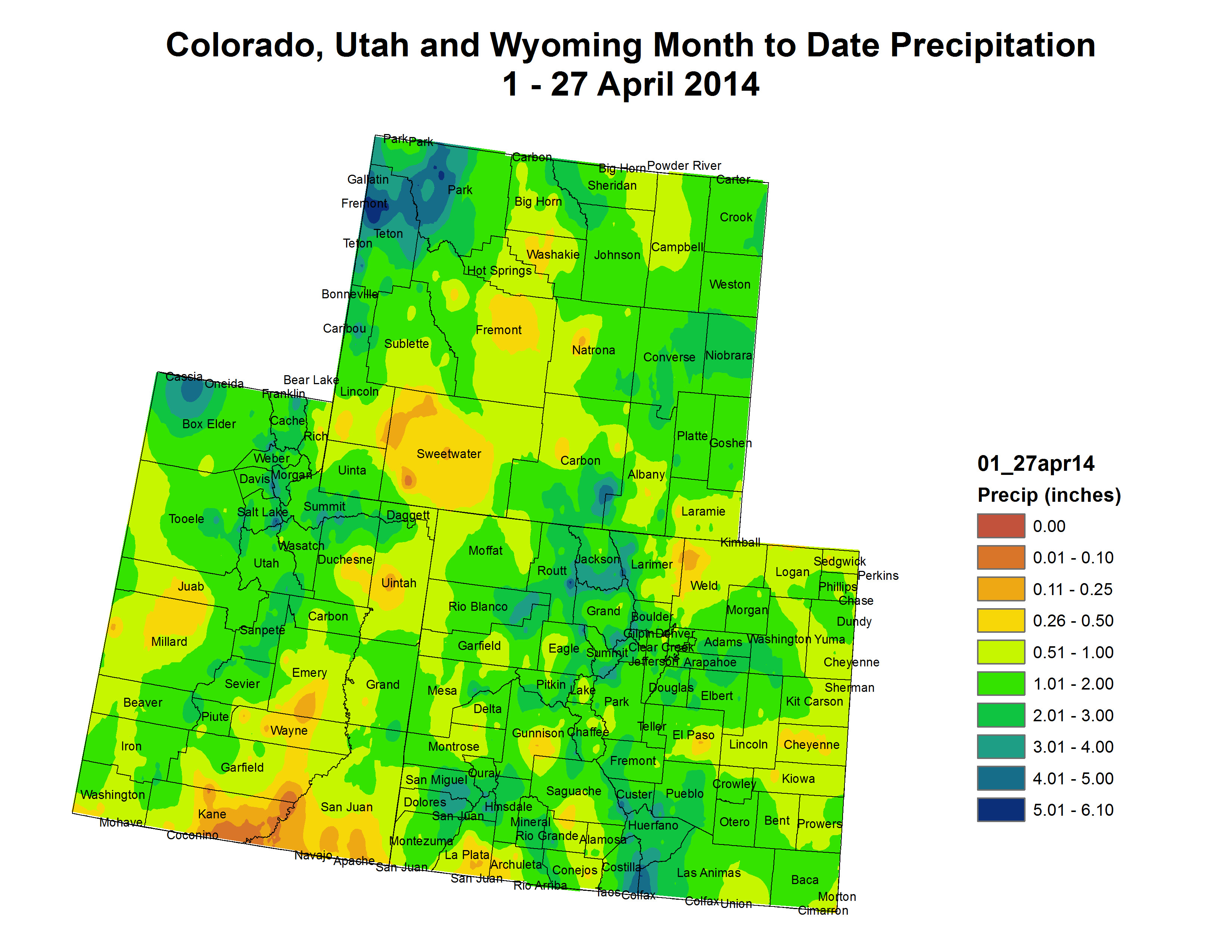
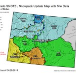
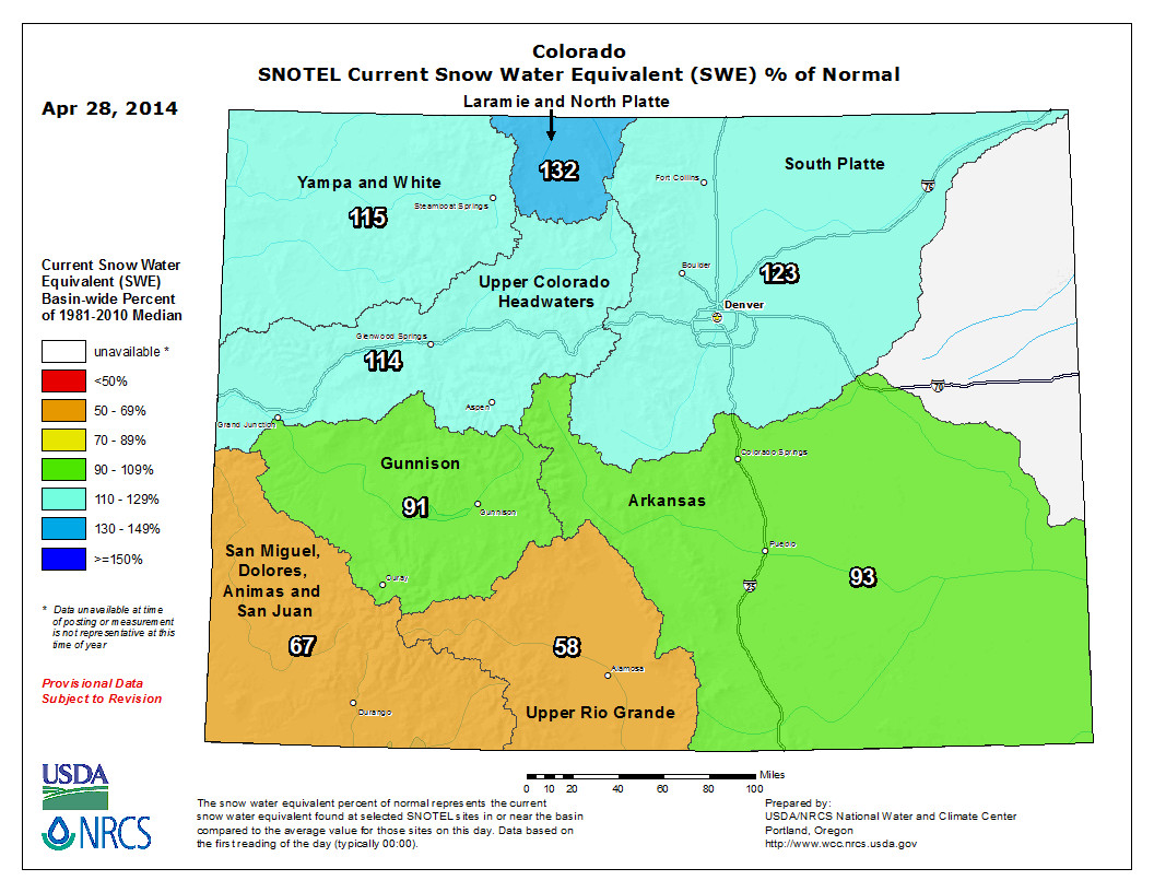
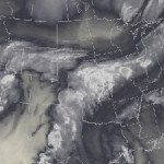
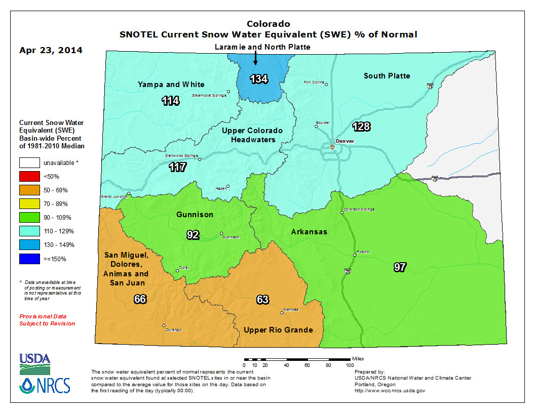
The National Oceanic and Atmospheric Administration released a drought summary Friday showing that the Park and Elkhead mountain ranges that wrap around Steamboat Springs and Craig are among a few pockets in the West enjoying above-average moisture and snowpack during the water year that began Oct. 1, 2013…
Based on snowpack, moisture in Routt and Moffat counties ranges from 113 percent to 132 percent of the median for April 25. And that positive trend extends to Wyoming and particularly the northwest corner of that state, where snowpack is near 150 percent of average near Jackson, Wyo.
Moisture is even higher in west central and northern Montana where snowpack is as much as 164 percent of the median. Northern Washington’s snowpack also is more than 100 percent, but central Oregon is in the 50th percentile and some places in southern Oregon are just 20 percent of median.
There are portions of north Texas and Oklahoma’s panhandle that have not seen rain in 140 days.
Conditions in Moffat County are “abnormally dry,” according to NOAA’s drought monitor, but do not meet the standard for moderate drought conditions. Routt, Jackson, Grand, Summit, Eagle and many of the counties straddling the Continental Divide in Colorado are free of any drought listing.
In spite of the abundant snowpack here, Steamboat has seen below-average April precipitation through Friday morning.
“Normal” precipitation in the city of Steamboat for the month of April is 2.41 inches, according to NOAA. As of 7 a.m. Friday, April precipitation had totaled 1.72 inches. The 6 inches that had fallen as of the end of the week compares to a “normal” monthly average in town of 13.1 inches. You can find that data at the National Weather Service by clicking on “nowdata” and searching for Steamboat Springs.
Just to the west of Colorado, the snowpack in far eastern Utah that includes the La Sal, Abajo and Henry mountain ranges is just 4 percent of what is typical this time of year.
Across the West, 61.6 percent of the land mass is reported as being under moderate to exceptional drought conditions, up from 58.9 percent at the start of the water year. Some of the worst conditions are in southeastern Colorado, far eastern New Mexico, central Nevada and southern Colorado…
The National Weather Service is predicting that an entrenched ridge of high pressure will bring colder than normal temperatures east of the Rockies from Thursday to May 7, but warmer than normal temperatures to the West.
NOAA sees the drought persisting or intensifying in most of the West between now and July 31, excluding Montana, Wyoming and all of Colorado but the southeastern portion of the state.
Western New Mexico, however, could catch a break in July from a summer monsoon that would improve drought conditions and even remove them in an isolated area of the state.
On Highway 72 up Coal Creek Canyon, many of the culverts damaged by last September’s catastrophic floods remain collapsed, damaged or clogged…
The Colorado Department of Transportation and Denver Water are working with residents to fix problems even though many of the culverts lead to private driveways and are privately owned, like the one on Crescent Lake Road.
“We recognize that that canyon has been through a lot,” said CDOT engineer Stephen Harelson. “So we’re just trying to keep another issue from happening.”
“Access culverts are the responsibility of the property owner rather than CDOT, but CDOT is attempting to find ways to keep them clean and be a good neighbor,” Harelson added.
Denver Water spokesman Travis Thompson said the utility met with residents on Crescent Lake Road on Thursday. And even though the collapsed culvert is privately owned, Denver Water plans to make the repairs to the culvert as a good faith measure.
Dust streaming across Four Corners April 29, 2009 via MODIS
For longtime locals, the final day on the Vail Mountain ski slopes is a customary ritual, the last chance to make use of the nearby network of chairlifts and cruise spring snow before the so-called “mud season” transition to summer. While the mountain attracted its fair share of disciples on the Easter Sunday closing last weekend, some of the region’s most dedicated skiers went the opposite direction, recognizing that the best snow to be found was already in the Colorado River.
“The brown frown is bringing me down,” said Mike Wertz, a 23-year resident of Vail whose ski days regularly approach triple digits. “I’d much rather be doing this.”
Despite above-average snowpack on his home hill, Wertz had joined a throng of stand-up paddle (SUP) surfers and kayakers making the most of an unseasonably early spike in the spring runoff at the Glenwood Springs Whitewater Park. Mud season, it seems, has turned to dust season, and impacts of the gritty layers of dirt covering the mountain snowpack — Wertz’s “brown frown” — have been revealed twice over: both as bad skiing conditions and increasingly early runoff.
Make no mistake, the dust-on-snow phenomenon is real. And it’s making a mess of things in the Colorado Rockies. During recent years, desert dust carried by strong winds has been settling thick and dark on the snowpack in the Rocky Mountain headwaters of the Colorado River. Snow dusted with dark particles absorbs more of the sun’s rays and melts faster than clean snow. According to researchers at the National Oceanic and Atmospheric Administration’s Cooperative Institute for Research in Environmental Sciences (CIRES) at the University of Colorado in Boulder, the snowpack is melting out some six weeks earlier than it did in the 1800s. And the problem appears to be getting worse.
It’s not an issue to be underestimated. Studies dating to the moderately dusty years of 2005-08 show that the dusty snowpack robbed the Colorado River of 5 percent of its flow before it reaches the Grand Canyon, equating to about 750,000 acre-feet annually, or about twice what the city of Denver uses. During 2009, 2010 and 2013, scientists observed unprecedented amounts of desert dust falling on Colorado snowpacks, about five times more than observed from 2005-08. Those extra layers of dirt resulted in an extra percentage point of water loss as snowmelt creeps earlier into the spring, and less water is left for later in the year. Never mind the future exacerbation of climate change models. It’s a phenomenon that already has been observed this spring as the Colorado River surged to more than 8,000 cubic feet per second (cfs) in Glenwood and 14,000 cfs at the Utah state line last week.
“The surging being logged on streams throughout the Colorado mountains is likely to be sustained until at least (this past) weekend,” reported Chris Landry, who heads up the Colorado Dust-on-Snow program as director of the Silverton-based Center for Snow and Avalanche Studies. “Several watersheds experienced flows (Tuesday) that approached their median peak flow levels.”
In other words, the water is rising, and fast. Landry only capped the stream surge this weekend because of a forecast for more snow that should temporarily cover the dust — and potentially add to it. The thing is, dust doesn’t melt. It merely grows darker and more concentrated as the snow beneath it melts, exponentially increasing the rate of runoff as the sun’s intensity grows with the approach of summer.
The research suggests that we can keep the snow on our mountains longer if we can figure out a way to adopt dust-reducing land management strategies and rehabilitate major dust sources in the Southwest. Meanwhile, we are forced to adapt.
“In the Upper Colorado River Basin, the snowpack is our most important reservoir,” said dust-on-snow research pioneer Thomas Painter of NASA’s Jet Propulsion Laboratory. “With continued dusty years and greater warming, water managers will have to make their decisions very early in the season. No longer will they have the nice long snowmelt season, shortened as it already has been, to see how snowmelt runoff is going.”
And neither, apparently, will the skiers and river runners.
Durango Mountain Resort is getting ready to sue the U.S. Forest Service over access to its water rights – rights it needs for future development on the mountain.
The dispute comes at the same time the Forest Service is under fire nationally for its attempts to force ski resorts to turn over their water rights as a condition for getting their permits renewed.
Meanwhile at the state Legislature, a bill by Sen. Ellen Roberts, R-Durango, to curb the Forest Service’s water-rights policy appears to be dead as Democratic leaders defer to the federal agency for the second consecutive year.
Roberts’ bill would not help Durango Mountain Resort, which has a slightly different dispute with the Forest Service. But the resort’s CEO, Gary Derck, sees a pattern of the Forest Service trying to get control of ski resorts’ water rights…
The ski resort owns conditional water rights to six wells on the back side of the mountain, on land its previous owners traded to the Forest Service in the 1990s. The trade did not include water rights, but the agency now says it will not allow Durango Mountain Resort to access the wells.
Lawyers for the Forest Service have asked a local water judge to deny Durango Mountain Resort’s rights to the wells. The resort’s rights are conditional, and it needs to prove to a water judge every six years that it is working toward making the rights absolute and putting the water to use.
But starting in 2010, the Forest Service began opposing the ski area in water court.
“Any additional proposals to divert and convey water from the upper East Hermosa Creek will not be accepted by the San Juan National Forest and authorization will not be granted,” former Forest Supervisor Mark Stiles wrote in a June 2012 legal filing.
The ski area’s owners say they have legal rights to access their water rights, and after several years of wrangling with the Forest Service, they are getting ready to sue.
“We’re trying to find a way not to go to court because it would be expensive, and we’re just a little old ski area down here in Southwest Colorado,” Derck said.
New polling shows voter support for a stormwater fee in El Paso County, and even more as voters become educated about the need. The fee is important to Pueblo County because it could raise $1 billion over the next 20 years to reduce the impacts of floods on Fountain Creek. Last November, 50 percent in El Paso County opposed the fee, while 44 percent were in favor. In March, 53 percent favored the fee, with only 35 percent opposed, said Dave Munger, co-chairman of a citizens task force on stormwater control.
“We’re very encouraged by that, especially because we have not gotten an educational program going,” Munger told the Fountain Creek Watershed Flood Control and Greenway District Friday.
The polling showed that by building certain provisions into the proposal, support could increase to more than 60 percent as the task force moves to convince El Paso County commissioners to put a stormwater proposal on the November ballot.
If the average homeowner paid $9 per month, the fee would raise $50 million per year in the Pikes Peak region. That’s three times the amount generated by a stormwater fee sunk by the Colorado Springs City Council in 2009.
That money would address projects envisioned in earlier stormwater studies as well as new concerns caused by the Waldo Canyon and Black Forest fires, Munger said.
The proposal would limit the administrative fee to just 1 percent — about $500,000 per year. It also would return the money to communities proportionately and include a 20-year sunset period for capital projects. A 13-member board weighted toward Colorado Springs would develop a master plan that would prioritize projects.
While the money would be redistributed on a pro rata basis, it still could be used for retention ponds or dams as envisioned by the Fountain Creek board.
“This will make El Paso County’s stormwater control efforts greater than it has ever been before,” Munger said.
Pueblo County Commissioner Terry Hart asked Munger to explain why the Fountain Creek district could not administer the plan.
“What I would like to know is if you see a role for the district,” Hart said. “A lot has gone into forming this district, including trying to navigate the politics and differences between the two counties.”
Munger replied that the proposal is built on agreements that would be signed by Colorado Springs, El Paso County, Fountain, Manitou Springs, Green Mountain Falls, Monument and Palmer Lake.
“We’re focused on getting voter approval,” he said.
Once the stormwater authority is formed, it could contract with the Fountain Creek district for projects. It might also accept new members, including Pueblo County, city of Pueblo and Teller County areas within the watershed.
“I don’t know why we couldn’t take advantage of this structure,” Munger said.
Recent estimates show a backlog of $740 million in El Paso County stormwater projects, but more could develop. At the end of 20 years, voters could be asked to renew the fee, Munger said.
A groundwater bill supported by a group of local farmers and the Central Colorado Water Conservancy District in Greeley has been defeated. House Bill 1332 — aimed at providing relief for areas of Weld County and elsewhere where groundwater wells have been curtailed, and where high groundwater levels have caused damage — narrowly passed out of the House Appropriations Committee by a 7-6 vote Wednesday morning, but that afternoon was defeated 36-29 when it went to the House floor, according to Rep. Randy Fischer, D-Fort Collins, who sponsored the bill.
“It’s disappointing,” said LaSalle-area farmer Glen Fritzler, an outspoken proponent of the bill, whose groundwater wells had been curtailed in recent years, whose basement flooded and who also helped form the Ground Water Coalition. “It might be the end for us in this legislative session, but we’ll certainly try again next year.”
HB 1332 called for de-watering measures in areas of high groundwater, funding for more groundwater monitoring and studies, and potentially creating a “basin-wide management entity.”
The bill struggled for support from other water circles in the state.
Earlier this month, the Colorado Water Congress voted 20-3 against supporting the bill, and members of the South Platte Basin Roundtable — a group of water officials and experts who meet regularly to discuss the region’s water challenges — spoke out against the bill.
Rather than support the proposed legislation, the roundtable voted in favor of having further discussions about the high groundwater levels and curtailed wells, and, if reaching consensus on the issues down the road, adding such suggestions to the South Platte basin’s long-term water plan and eventual statewide Colorado Water Plan, which are currently in the works.
The majority of South Platte Roundtable members said at that meeting that such measures, like the de-watering efforts, are more complex than they appear. They also said the state putting forth more dollars for more groundwater studies is unnecessary since the recent Colorado Water Institute’s study is available for further examination, and the State Engineer’s Office is in the midst of a separate groundwater study.
Furthermore, creating an entity for basin oversight would just add “another layer of unnecessary bureaucracy.”
Wednesday’s defeat was another setback for LaSalle and Gilcrest area farmers, who, due to changes over the years in the state’s administration of groundwater, had their groundwater wells curtailed or shutdown several years ago. They’ve pushed for several other bills this year and in recent years that address the issue, but have been voted down.
For someone to legally pump water out of the ground in Colorado, most wells must have an approved augmentation plan to make up for depletions to the aquifer. The pumping of that groundwater draws down flows in nearby rivers and streams — surface supplies owned and used by senior water rights holders. But, because of increasing water prices, some in the ag community struggle to find affordable water they can use for augmentation.
In addition to losing the ability to pump their wells, many of those impacted believe the lack of well-pumping and increased augmentation is what’s caused the high groundwater levels that in recent years flooded basements and ruined crops in saturated fields. Many believe, however, that the high groundwater levels in recent years were caused by a variety of factors, and the existing system for groundwater management is needed to protect senior surface water rights.
FromThe Grand Junction Daily Sentinel (Charles Ashby):
Democrats in the Colorado Senate are considering a bill to place more controls over uranium mining that opponents say are duplicative and unnecessary. The measure, SB192, would require uranium and thorium mines to get a radioactive materials license from the Colorado Department of Public Health and Environment, and meet certain criteria for keeping contaminated materials out of the state’s groundwater supplies.
But opponents say federal and state regulations over such things are already stringent, and the proposed changes are being pushed by anti-nuclear energy advocates who want to stop all uranium mining.
Harold Roberts, chief operating officer of Lakewood-based Energy Fuels, the company that has been working to open the Pinon Ridge Mill in western Montrose County for the past three years, told the Senate Health & Human Services Committee that the measure is fraught with problems. He told the panel, which approved the bill Thursday on a 4-3 party-line vote, the measure only increases red tape, would spark more litigation and would have no impact on protecting public health or the environment.
“My point is, we’re highly regulated and I don’t see that SB192 would do anything to improve those regulations,” he told the seven-member panel.
Much of the testimony for the measure stemmed from residents who live near the Cotter Uranium Mill near Canon City, a uranium processing mill that was declared a U.S. Environmental Protection Agency Superfund clean-up site in 1984.
Opponents to the measure said that much has changed since then, and state and federal regulations today are far more stringent to prevent such a thing from happening elsewhere. Roberts said his proposed mill has spent more than a $1 million over the past three years in extra groundwater investigations and facility upgrades at the request of state regulators.
Last year, the company received a radioactive-materials handling permit from the state, but it is waiting to build the $150 million mill located near Naturita until the price of yellowcake, a uranium concentrate powder, increases. Currently, those prices are at a fraction of what they were before the recession began in 2008.
The bill heads to the full Senate for more debate.
Map of oil shale and tar sands in Colorado, Utah and Wyoming — via the BLM
FromThe Grand Junction Daily Sentinel (Gary Harmon):
Microwaving rock in northwest Colorado could turn the oil shale business inside out, said a Grand Junction inventor who is working to restart oil shale at a time when many are pulling away from it. Using equipment small enough to be loaded onto two trucks traversing the surface could result in minimal surface disturbance, said Peter Kearl, a Grand Valley native who heads Qmast LLC, http://www.qmast.com, the company pursuing the project.
Not only would his technology disturb little of the surface, it also would likely produce — rather than use — water, Kearl said.
It could be run using natural gas from the Piceance Basin itself as a fuel source and leave behind subterranean caverns that could be used for carbon sequestration, Kearl said.
Most approaches to developing oil shale, from retorting it above the ground to mining and in-situ heating in large expanses, have run afoul of environmental and cost concerns.
Rather than employing a “big-risk, big-reward” approach such as that of Royal Dutch Shell before it pulled out of oil shale entirely last year, Kearl said he’s hoping to use a more measured approach and achieve more reliable and regular results.
Several other oil shale ventures are pushing ahead in Utah, and Kearl acknowledged that it might be easier to test his technology across the state line.
“But I’m a Colorado boy,” he said, voicing his preference for developing oil shale in the Centennial State.
He has a geology degree from what was known then as Mesa College and a degree in hydrogeology from the University of Nevada.
It also helps that the richest, though deepest, deposits of the Green River Formation’s oil shale are in the northwest corner of Colorado. Colorado, Utah and Wyoming contain the world’s largest deposits of oil shale that contain as many as 4.2 trillion barrels of oil, according to recent estimates.
Applying microwaves to heat- targeted areas of rock makes more sense than heating large areas using other methods of heating, Kearl said.
“The fundamental physics are definitely on our side,” he said.
The process would send the microwave equipment down a well to heat the hydrocarbon-bearing rock to the point that it would release crude oil that then could be collected by conventional drilling, he said.
The technology could tap shale on steep slopes from the side, allowing the oil to simply flow out, he said.
He presented his idea in 2012 at the SLAC National Accelerator Laboratory on the Stanford University campus.
The more targeted approach he advocates could prove to be a financial success, Kearl said.
A well 300 meters deep could produce revenue of $80 million, based on $100-per-barrel crude prices, he said.
Kearl and his partners are working to arrange financing of $5.5 million for a test. That step is difficult because the federal government appears to be uninterested in making available any more land for research, demonstration and development leases.
The effective ban on experimentation “thwarts inventiveness,” Kearl said.
So he’s also looking for a small parcel of land, a quarter of an acre would do, on which to test his technology, including his estimate that he could produce about half a barrel of water for each barrel of oil he produces.
The patented microwave technology he’s considering wouldn’t require a large electricity supply, he said, because the process also would produce natural gas, which could be used to fire the generators for the microwave equipment.
The city’s Open Space and Howelsen Hill Facilities superintendent wasn’t totally surprised by what he saw on the face of the city-owned ski area, but this mudslide was something he had hoped he wouldn’t see this spring.
“I never know what to expect,” Robinson said before he climbed up the steep slopes to get a closer look at what was happening. “Just about every year, something is moving up here.”
A few minutes later, Robinson was investigating what might have caused the hill to slide and was snapping a few photos to record the slide’s progress.
He has been watching the hill since Tuesday when two small cracks appeared halfway up the slopes between the first and second exits for the Poma lift. Robinson said he could see the cracks getting larger and the hill changing every day. Today when he showed up, it was easy to see where large chunks of the hill had broken loose and two rivers of mud reached for the bottom of the hill.
“Each day it has progressed a little bit more,” Robinson said. “We noticed it on Tuesday for the first time. The next morning we saw the highest crack, which is visible now. Each day it has changed a little bit and shifted down hill with gravity.”
Robinson said he has talked to soil engineers, and Northwest Colorado Consulting has been working with the city on all the slides that Steamboat has had throughout time. He said it’s a wait-and-see approach right now.
“We are hoping that it will stay in place, and if it comes down, we will have to see what the recommendations are for putting it back together,” he said.
This isn’t the first slide on Howelsen Hill’s steep-pitched slopes. Last year, there was a small slide just below this year’s slide. In 2011, the city repaired a slide area near the Alpine Slide, and in 2004, a section of Howelsen Hill’s largest ski jump slid.
Robinson said it would take some time before crews could begin to repair the damage. He thinks that heavy equipment will be brought in to push the soil back up the hill, where it will be packed and eventually seeded in order to keep the ground in place.
Many county officials and land managers are bracing themselves for a runoff season comparable to 2011, which ripped up roads, clogged culverts, surged rivers, flooded farms and caused a lot of distress for county residents.
The latest snow data will be reported on May 1, but according to this month’s Natural Resource Conservation Service snow survey, snowpack for the Upper Colorado River Basin was at 144 percent. In 2011, April’s snowpack was at 135 percent.
“My guess is to be ready for a year like 2011,” said Mark Volt, snow surveyor for the NRCS, in am email. “(It) all depends on if it keeps snowing and how fast it warms up now.”
Air search for flood victims September 2013 via Pediment Publishing
Plume of subtropical moisture streaming into Colorado September 2013 via Weather5280
Here’s a report about Jamestown’s recovery from TheDenverChannel.com (Jaclyn Allen, Brad Bogott, Brian Hernandez). Click through for their photo gallery. Here’s an excerpt:
In the middle of September’s flooding, Jamestown was cut off by floodwaters on all sides, leaving only destruction in its wake…
Mayor Tara Schoedinger said things are getting better every day in Jamestown. But she added that the process has been tough.
“The last 7 1/2 months have been, probably, the most difficult in our lives,” said Schoedinger.
With the help of federal funding, engineering experts have come in to stabilize the river that runs through the town.
“We have to understand how the stream behaves, how it moves material and then we design ways for the water to come down the stream to make their way through town without causing the kind of damage we saw last September,” said Marco Aieta with the engineering company AMEC.
Graeme Agget with AMEX said he’s confident that the river is this a lot more stable than it was back when they started the repair work
“It really is about survival. This is a small mountain town and if we can’t put the infrastructure back in play for people to live here they’re going to have to find someplace else to go,” said Aieta.
Colorado-Big Thompson Project east slope facilities
From email from Reclamation (Kara Lamb):
You’ve likely noticed the water level at Pinewood dropping again. While this is typical for this time of year (Pinewood often fluctuates for power generation), we’ll be going a little lower, back to the 6560 foot level seen last month. The reason is the same: more canal maintenance downstream of the reservoir.
We are anticipating we’ll hit the 6560 elevation on Tuesday, April 29. Water level elevations will begin going up again on Wednesday the 30th, and the reservoir should be close to full again by next weekend, May 3.
From email from Reclamation (Kara Lamb):
The weather front coming in over the weekend is probably raising some questions for folks. I want to reassure you all that we do not anticipate any major changes at Olympus Dam or Lake Estes as a result of this weekend’s forecast.
The reservoir’s water level has dropped down to about 85% of full. We will continue sending some of the inflow from the Big Thompson River to the Olympus Tunnel and on over to Horsetooth and Carter. We will continue releasing about 40 cfs through the dam on down to the canyon.
A district formed to fix Fountain Creek is moving ahead with a road map to build flood control dams between Fountain and Pueblo. The entire process could take 3-12 years to complete, with the type of structures chosen and the availability of money the determining factors.
On Friday, Larry Small, executive director of the Fountain Creek Watershed Flood Control and Greenway District, broke down the process into bite-sized pieces for the board, which was formed five years ago by the state Legislature to resolve Fountain Creek differences between Pueblo and El Paso counties.
Phase 1 would be to compare three alternatives that were modeled in a U.S. Geological Survey study completed this year. It would cost $60,000 and take up to a year to complete. Those include a large dam, a series of about 10 smaller dams or several midsize dams that would capture about the same amount of water.
“Maybe building fewer and bigger dams may be better than 10 small dams,” Small said.
Small said other alternatives in the USGS study either provided only local protection on other parts of Fountain Creek, or no protection at all to Pueblo in the event of a large flood. The study would corroborate past studies and identify — but not solve — issues with each of the alternatives. It would also use the USGS study to provide a visualization of floods of varying intensity, Small said.
The next phase would then compare the options by looking at engineering, easements, permits, costbenefit analysis and other factors.
“We want to be in a position that will allow us to begin building when the money becomes available,” Small said.
That money will start coming when Colorado Springs begins payment of the bulk of $50 million that it agreed to pay the district under Pueblo County’s 1041 permit for Southern Delivery System. The funding for the study would come from prepayment of nearly $300,000 in interest on the $50 million under the terms of the 1041 permit.
Pueblo County Commissioners and Colorado Springs still are negotiating the details of the prepayment, said Commission Chairman Terry Hart.
“What we’re trying to do is pave the way for the money, so the project can move forward,” Hart said.
More Fountain Creek watershed coverage here and here.
In light of the most recent snowpack report, the Rio Grande Basin is no longer at the bottom of the list in the state but it’s close.
Colorado Division of Water Resources Division 3 Engineer Craig Cotten reported to the Rio Grande Water Conservation District board yesterday the Rio Grande Basin was 73 percent of average as of Monday morning, April 14. The basin, which encompasses the San Luis Valley, had been the lowest in the state for snowpack but is now barely above the Durango area, which sits at 71-72 percent of average, Cotten said.
“Most of the other basins in the state are above 100 percent,” he added.
This will be the sixth year in a row the Rio Grande Basin has registered a belowaverage snowpack, which will result in a below-average run off, Cotten explained. The basin had risen to a point slightly higher than the previous three years until about a week ago, Cotten said, when warmer temperatures hit and the snowpack dropped.
SNOTEL sites within the basin vary greatly, Cotten added, with snow measurements in the northern part of the Valley reflecting higher numbers than the southern part.
“Here in the basin, similar to the state as a whole, the northern streams are a little better than the southern streams,” he said.
The best, at 103 percent of average as of April 3, was Saguache Creek and the worst, at 35 percent of average, was the San Antonio River at Ortiz. On the same date, the Rio Grande at Del Norte stood at 80 percent of average , based on information from the USDA Natural Resources Conservation Services (NRCS), which operates the SNOTEL measurement sites. Cotten said NRCS has encountered budget crunches the last few years and has had difficulty maintaining their SNOTEL sites, with a move made to eliminate the manual snow measurement courses, but for the time being those are still in place. He said NRCS is looking for cooperators to help with funding the SNOTEL and snow course sites. Cotten added although NRCS has had trouble maintaining its SNOTEL sites, the data from the sites is “in the ballpark.” He said his office has nothing to prove them wrong but feels the data may not always be exactly correct. NRCS claims its data is good, he said.
Based on the NRCS forecast for April, the Rio Grande is predicted to run 505,000 acre feet this year, with 128,700 obligated to downstream states as part of the Rio Grande Compact. Since Colorado has already sent water downstream in January, February and March and will send more water downstream in November December, the amount calculated to be delivered during the irrigation season itself, April-October , is 42,000 acre feet, Cotten explained. To make that commitment, the water division will have to curtail irrigators by about 10 percent, he added. That is the current curtailment on the Rio Grande. The current curtailment on the Conejos River system is 6 percent, Cotten added. The April NRCS forecast for the annual flow on the Conejos system, which includes the Conejos River, San Antonio and Los Pinos Rivers, is 200,000 acre feet, with 45,000 acre feet obligated to New Mexico and Texas to meet the Rio Grande Compact . A great deal of that has been or will be sent downriver during wintertime, but the amount required to be sent downriver during the irrigation season is 11,000 acre feet. That accounts for the 6 percent curtailment.
While Colorado’s Rio Grande Basin may reflect below-average numbers, New Mexico is in much worse shape with snowpack in places well under 50 percent of average and even less than 10 percent of average.
The reservoirs used to store Rio Grande Compact water are located in New Mexico, with the main reservoir storage at Elephant Butte Reservoir. Currently that reservoir has about 302,000 acre feet of compact usable water but is only seeing inflow of about 123 cubic feet per second (cfs), compared to the average inflow of more than 1,000 cfs, “so they don’t have much flow at all into the reservoir,” Cotten said. He added that once the irrigation season begins below the reservoir the water will diminish even more. New Mexico irrigators will begin irrigating below Elephant Butte in May. Cotten reminded the group that as long as Elephant Butte is below 400,000 acre feet which will be the case all year Colorado cannot store water in reservoirs built after the Rio Grande Compact was ratified. Those post-compact reservoirs include Platoro.
Regarding weather forecasts for the next three months May, June, July the Valley is showing equal chances of having average precipitation. That is better news than the last three years when the summer months reflected below-average precipitation forecasts for this area, Cotten said.
As this winter’s banner snowfall helps refill mountain reservoirs drained by the historic drought of 2012, it’s also allowing administrators of at least two major trans-mountain diversion water projects in the Roaring Fork watershed to plan for larger-than-normal diversions to the Front Range this year.
The Fryingpan-Arkansas Project is expected to divert 73,000 acre-feet of water in 2014 from the headwaters of the Fryingpan River above Ruedi Reservoir to the Arkansas River basin on the East Slope. One acre-foot is equivalent to 325,851 gallons, and over the last 12 years, the project has diverted an average of 54,000 acre-feet, making this year’s projected diversion 35 percent larger than average.
The Twin Lakes Reservoir and Canal Company, which manages a four-mile-long tunnel piping water from the headwaters of the Roaring Fork River on Independence Pass to the Arkansas River basin, is also tentatively planning to divert between 53,000 and 55,000 acre-feet of water this year. According to Kevin Lusk, the president of the company’s board of directors, that’s as much as 20 percent more water than the project’s average annual diversion of about 46,000 acre-feet, most of it destined for the cities of Colorado Springs and Pueblo.
But at least one other trans-mountain diverter — the Pueblo Board of Water Works — is actually planning to pipe less water to the East Slope this year through the Busk-Ivanhoe tunnel above the Fryingpan than usual, since above-average snowpack in the Arkansas River basin should help the city meet its water needs…
Although peak runoff is likely weeks away, all three of the trans-mountain diversion projects in the Roaring Fork watershed are already piping water to the East Slope. On Sunday, a gauge at the Twin Lakes Tunnel’s entrance registered a flow of 22.3 cubic feet per second, or roughly 10,000 gallons per minute, heading into the tunnel. Similar gauges at the Boustead Tunnel (part of the Fryingpan-Arkansas project) and the Busk-Ivanhoe Tunnel registered flows on Sunday of 2.49 cfs and 1.43 cfs, respectively…
The ample water supplies that make historically large diversions possible also are aiding local reservoirs this year. Storage in the Colorado River basin’s reservoirs hovered around 93 percent of average on April 1, up from just 65 percent of average on the same date in 2013.
The storage picture is likely to improve even further in the coming months. Mage Hultstrand, a hydrologist for the National Resources Conservation Service, told a meeting of the Governor’s Water Availability Task Force in Denver this past Wednesday that snowpack in the Colorado River basin stood at 130 percent of average as of April 1. That early surplus means that the basin could still have an average water year even if it received just 83 percent of normal precipitation for the rest of 2014, Hultstrand said.
At last week’s task force meeting, officials charged with securing water for Front Range cities like Denver, Fort Collins and Colorado Springs said their own reservoirs already are between 80 and 90 percent full, even though peak spring runoff is likely more than a month away. The healthy storage numbers make it less likely — though not impossible — that Front Range cities will have to institute mandatory watering restrictions this summer like they did during the drought of 2012…
As residents of southern Colorado contemplate a high-risk fire season, people along the Front Range have another sort of natural disaster on their minds this spring: floods. Last September, flash flooding destroyed and damaged homes, roads, bridges and other infrastructure in 20 Front Range counties. Now, concern is running high that when runoff courses down through stream and riverbeds that were rerouted by last year’s floods, a second round of flooding could result.
Many Front Range communities are racing to get ahead of the threat by stabilizing stream banks, shoring up roads and putting other watershed protections in place before spring runoff kicks into high gear next month.
Robert Glancy, a meteorologist with the National Weather Service, told last week’s task force meeting that recent bouts of warm weather in the central mountains have helped jump start the spring melting process, drawing down the snowpack and reducing the likely strength of future floods.
“I’m glad that we’re melting now, because it’s wearing down the snowpack,” Glancy said.
The snow that pounded Colorado’s high country all winter – delighting skiers with an extended season – looks poised to bring thrills to the state’s whitewater enthusiasts. Not to mention the businesses that put them in the water…
Cumulatively, the Arkansas River Valley is at 102 percent of the mean snowpack, or about average, according to the Natural Resources Conservation Service, which measures snowpack across the state. Hidden among those numbers is a much-better-than-average snowpack in waterways near the river’s headwaters, Hamel said, calling them a key indicator for good rafting. He said a high moisture content in the soil also will help generate runoff into the area’s waterways, bolstering water from snow melt.
While the numbers are worth cheering, they’re nothing compared with the Laramie and North Platte river basins, which are at 139 percent of mean. The Yampa and White River basins are at 121 percent, the Upper Colorado River Basin is at 123 percent, and the South Platte River Basin is at 132 percent.
But heavy snowpacks are hardly universal. Missing out on the trend are basins in southern and southwestern Colorado, which suffered an anemic winter.
The Upper Rio Grande Basin is at only 67 percent of the mean, and the San Miguel, Dolores, Animas and San Juan river basins are at 73 percent.
Predictions about the health of the rafting season rest on hopes for mild temperatures early in the season. A rapid melt could mean bad news for rafting companies, which look for a stable, long runoff to keep flows moving into the peak tourist period, generally from mid-June to mid-August.
Dust picked up by storms in Utah, Arizona and New Mexico and then dumped on Colorado’s high country also can enter the mix, leading to quicker melts.
While the Colorado River Water Conservation District recorded at least eight large dust storms this winter, the state’s snow packs might be deep enough to weather effects of the dust, general manager Eric Kuhn said.
In some areas, including the Colorado River Basin, the deep snow might be a double-edged sword, sending outfitters on a hunt for waterways that aren’t dangerously high.
Denver Water has been regulating its outflow at the Dillon Reservoir dam to get ready for all the snow to melt. Right now the output is around 700 cubic feet per second and there’s already one rafting companytaking advantage of all the water.
“Today is the start of our 2014 rafting season,” Campy Campton with Kodi Rafting said on Thursday.
It’s come about a week or two earlier than normal. The above average snowpack is starting to melt, and that means rivers are already moving…
“This is really early, especially for the Blue River, but we had some folks that are interested in boating today and we were coming out anyway, so we brought them along for the fun,” Campton said. “This is one of the few rivers in the state of Colorado that’s solely dependent upon dam release for the river to flow.
“We boated the Blue the last time in 2011. We saw enough water to come down here commercially and boat and have fun.”[…]
The River Outfitter’s Association said there are other places like the Animas River around Durango, the Colorado River near Glenwood and the Arkansas River around the Royal Gorge that are also seeing companies get an early jump on the season.
Click on a thumbnail graphic to view a gallery of drought data from the US Drought Monitor. Click here to go to the US Drought Monitor website. Here’s an excerpt:
Summary
Weather systems moving in the upper-level westerly flow generated low pressure systems and surface fronts which moved across the contiguous United States (CONUS) this U.S. Drought Monitor (USDM) week. Two storm tracks resulted, with one moving across the northern tier states and the other from southern New Mexico, across the Gulf of Mexico coast, and up the East Coast. Above-normal rainfall was widespread across southern New Mexico, the Texas Trans Pecos, and the coastal Southeast. Below-normal precipitation dominated the rest of the country, with much of the Southwest again receiving virtually no precipitation. Weekly temperatures averaged above normal in the West and below normal in the East…
The Plains
Drier-than-normal weather dominated the Plains this week and much of the last 6 months. A colder-than-normal winter and early spring have delayed agricultural activities; April 21 USDA reports indicated that the condition of winter wheat has declined in Kansas, with winter wheat condition rated poor to very poor for 32% of the crop in Kansas, 12% in Nebraska, and 4% in South Dakota. The USDA rated topsoil moisture conditions short or very short (dry or very dry) for 72% of Kansas, 54% of Nebraska, 50% of Colorado, and 23% of South Dakota. D0 expanded across eastern South Dakota to reflect dryness at the 30-day to 6-month time scales. Most of Kansas and Nebraska were already in moderate to extreme (D1-D3) drought, but an oval of D3 was added in central Kansas and D2 expanded eastward from there to reflect extreme low precipitation values at 30-90 days, as well as poor USDA soil moisture and crop condition reports. In southeast Colorado, D3-D4 expanded while the western edge of D0-D1 contracted. The D3 expansion in southeast Colorado bled into western Kansas…
The West
Parts of the coast and Cascades of Washington were wetter than normal this week, with stations receiving 3 inches or more of precipitation, and some locations reporting over 5 inches. An inch or two of precipitation was widespread over western Oregon, yet the week ended up drier than normal. Parts of the northern and central Rockies received an inch or more of precipitation, which was above normal in places. An upper-level system dropped a third of an inch to an inch of rain over southern New Mexico, which was above normal for the week. Otherwise, precipitation amounts were half an inch or less, with the southwestern third to half of the West receiving no precipitation. Mountain snowpack was below normal, except for the Washington ranges and northern and central Rockies, with continued warmer-than-normal temperatures accelerating the melting of the meager snowpack in the California Sierras.
In Arizona, livestock water tanks were dry so water hauling was an issue on ranges that don’t have water improvements with pumps, tanks, and pipes. D2-D3 expanded in southeast Arizona where stream levels continued to fall and evaporation was high. A very high fire danger and low precipitation at long (multi-year) time scales prompted the expansion of D1 in southwest Arizona and adjoining California and conversion of the S impact indicator to SL. In New Mexico, wetness in July and September 2013 masked longer-term dryness. October 2010-March 2014 was the third driest such 42-month period in the 1895-2014 record; it would be the driest if not for the July/September rains. Another dry week combined with this long-term dryness to expand D4 in northeast New Mexico. In Nevada, D3 expanded in Nye and adjacent Mineral counties, and the D1 donut hole was eliminated in southeast Nevada. The L impacts boundary along the Colorado-Utah-Wyoming boundary was pulled back where soil moisture deficits and short-term precipitation deficits indicated the SL timescale squeezing the L impacts region.
D2 and D3 expanded in northern California and parts of southern Oregon, with D2 spreading along coastal Oregon up to Lake County where precipitation deficits and low streamflows were most significant. D4 expanded further in the San Francisco Bay area and across all of Monterey County. In California, the city of San Diego was proposing a water supply “level 1” status, and a small reservoir/water district in Riverside County was on the 30-90 day “watch” list for depleted supplies. The San Antonio Reservoir has been essentially dry through the entire winter and Nacimiento Reservoir was at 22% capacity. The City of Montague risks running out of drinking water by the end of summer and has requested that all outside watering be curtailed until further notice; this is the first time in over 80 years of water deliveries from the Montague Water Conservation District (MWCD) that this situation has occurred. Growers in Shasta Valley with the primary irrigation district (MWCD) were expected to have only enough irrigation water to irrigate what would equate to a single irrigation on about half of their acreage. Many growers in the Big Springs area have already started pumping water to irrigate field. Within 24 hours of when one grower started irrigating, two nearby domestic wells went dry. The frustration caused by the drought can be seen in a report by an observer in Siskiyou County: “Our snow pack is pathetic, rainfall is way below normal, (low) stream flows are running at 2-3 months ahead of normal depending on the area, well levels have dropped severely and many wells are dry in spring or have levels typical of late fall, surface water irrigation supplies are non-existent to extremely limited in many areas, and the situation is only getting worse daily (especially after 3 consecutive years of drought).” With the expansion of D1 across southeast California and southwest Arizona, this week marks the first time in the 15-year history of the USDM that 100% of California was in moderate to exceptional drought…
Looking Ahead
The NWS HPC 7-Day Quantitative Precipitation Forecast (QPF) calls for frontal-low pressure systems to bring an inch or more of precipitation across a large part of the country, stretching from the eastern and northern Great Plains to the Appalachians, with 3 inches or more across parts of the Midwest to Deep South. Another area of 2+-inch precipitation is projected for coastal Washington and Oregon, and parts of the northern Rockies, while the Southwest is expected to remain mostly dry. Temperatures for the April 24-30 period are predicted to be warmer than normal in the southern states ahead of the front, with colder-than-normal air from the north moving across the country behind the frontal systems.
The 6-10 day and 8-14 day outlooks indicate that an upper-level circulation pattern, consisting of a ridge over western North America and a trough over the east, is predicted to become entrenched during May 1-7, bringing colder-than-normal temperatures to the country east of the Rockies and warmer-than-normal temperatures to the West and Alaska. This period should be drier than normal for the Southwest and Great Plains into the Midwest, and wetter than normal across the Southeast, Ohio Valley, Northeast, and part of the Pacific Northwest. Southern Alaska is expected to be wetter than normal with northwest Alaska drier than normal.
Water that farmers have relied on in the past was not available during last year’s drought. While some water was available in the 2012 drought, two years was too much for the Arkansas Valley That should be a wakeup call for the future, Division 2 Engineer Steve Witte told the Arkansas River Basin Water Forum Thursday.
“Obviously, drought reduces the water that’s available for replacement,” Witte said.
Farmers need replacement water in order to pump wells, and now to operate sprinklers fed from surface ponds. That competition is increasing. A study for the Lower Arkansas Valley Water Conservancy District showed that the replacement water needs will double by 2050, as more farm improvements are needed. Right now, farmers use about 25,000 acre-feet (an acre-foot is 325,851 gallons) to augment wells and sprinklers. That could grow to a need of 50,000 acre-feet by 2050. But Witte presented figures that showed an even greater need already in place. From 2002-13, farmers used 39,000 acrefeet annually. About half of that came from drying up other farms. For the remainder, farmers relied on return flows from the Fryingpan-Arkansas Project or leases from cities, primarily Pueblo, Colorado Springs and Aurora. As the cities grow into their supplies, that water will be less frequently available.
Meanwhile, the Lower Ark district is helping farmers cope with increased water needs, supplying engineering and water resources. In the future, lease fallowing programs like the Arkansas Valley Super Ditch could meet some of the needs. Other strategies include groundwater recharge ponds, finding a way to use state-line credits to Kansas, securing Fry-Ark flows and improving on-farm conservation, Witte said.
“Can this continue?” Witte asked. “Where the water will come from, I don’t know.”
Water is critical to the Lower Arkansas Valley and must be protected from threats — economic, meteorological or political. That was the upshot at the final day of the Arkansas River Basin Water Forum Thursday at Otero Junior College.
“We’re continuing to go down a road the valley should be concerned about,” Beulah rancher Reeves Brown said, talking about past raids on valley water by cities. “If we can be a little more responsible about planning for the future, rather than taking what happens, we need to do that.”
The sentiment resonated throughout the room, with most heads nodding in agreement. At times it seemed the group was ready to boil into a march for the cause.
“Just because other areas of the state are exploding, why should they take the resources away from farms?” one woman commented. Others echoed the comments, with some urging more action and less talk.
Mostly, however, the meeting was a recitation of studies and opinions that indicate water will be an ever more precious commodity in the future.
Jay Winner, executive director of the Lower Arkansas Valley Water Conservancy District, said an upcoming study shows that agriculture is a $695 million business employing more than 4,600 people in the Arkansas River basin. On top of that, agricultural incomes contribute $317 million in spinoff benefits, while the recreation industry realizes $220 million in revenues because of agricultural water flowing in the Arkansas River. It also shows that for every 1 percent of water removed from the valley, there would be an economic hit of about $10 million.
Families also would suffer with the loss of irrigation water, said Michael Hirakata, whose great-grandfather came to Rocky Ford from Japan. Hirakata still runs the family farm, and he plans to turn it over to his children.
“We think we can’t live without our phones, but water is imperative,” Hirakata said. “I owe it to my ancestors to keep farming with my family in the Arkansas Valley.”
Las Animas County rancher Steve Wooten, one of the leaders in the fight against Pinon Canyon expansion by the Army, said political attempts to hamstring farmers also must be stopped.
Outside groups are sponsoring ballot initiatives that purport to encourage humane treatment of animals, but actually interfere with how ranchers make their living, he said.
“The most challenging thing to agriculture is not growth or drought, but political activism,” Wooten said.
From the La Junta Tribune-Democrat (Bette McFarren):
Water officials from all over Colorado gathered Wednesday at Otero Junior College Student Center for the 20th Arkansas River Basin Water Forum. Keynote Speaker was James Eklund, director, Colorado Water Conservation Board. His subject was “Colorado’s Water Plan.” “Basin Perspectives on Colorado’s Water Plan” was a panel moderated by John Stulp, Special Policy Advisor on Water to the Governor.
The Bob Appel Friend of the Arkansas Award went to Greg Policky, a biologist who worked to establish a high-quality fishery on the Upper Arkansas River. “His attention to detail and collection of objective fishery data has provided numerous benefits to the river’s fishery,” said Jean Van Pelt. He works with angling organizations and land resource agencies, but is most rewarded by working with school-age children.
Luncheon speakers Erin Mink and Brian McCain spoke on “Federal Water Rights Bills and Impacts to Colorado’s Water Supply.” Mink is from the office of Senator Mark Udall and McCain is from the office of Congressman Scott Tipton.
The “How Did We Get Here?” panel had some familiar faces for the people of Otero County: Moderator Gary Barber, West Water Research; James Broderick, Southeastern Colorado Water Conservancy District; Jay Winner, manager of Lower Arkansas Valley Water Conservancy District; Terry Scanga, Upper Arkansas Water Conservancy District; Jeris Danielson, Purgatoire River Water Conservancy District. Broderick will be remembered as the creator of the financial structure which enabled the financing of the Arkansas Valley Conduit. Winner is the spokesperson for the Super Ditch and the Rule 10 Plan, which hold out hope for an alternative to buy and dry for local farmers and a way to adjust augmentation water due to Kansas which allows farmers to use sprinklers and drip irrigation. Scanga is a specialist in the upper Arkansas, where water is brought over from the Western Slope. Danielson is from the Purgatoire basin, about 20 miles south of La Junta.
Scanga urged that all the water districts and entities work together for the common goal of good water for Colorado. Danielson and Winner stressed the importance of water storage and distribution. Broderick emphasized the financial aspect of planning: use the infrastructure you already have as much as possible. The alternative is “sticker shock” in utility bills. “Projects are expensive,” he reiterated. They all considered underground storage a possibility which would mean less loss to evaporation, as well as pipelines.
The next panel, “Where Do We Go Next?” was also moderated by Barber and featured Mark McCluskey, CDM Smith; Mark Shively, Conservation Consultant; Kyle Hamilton, CH2M Hill; and Mark Shea and Brett Gracely of Colorado Springs Utilities. Colorado Springs faces a huge issue in flood control.
With the water outlook now drastically better than it was in 2013, many Front Range cities in Colorado, which leased little or no water to ag users last year due to shortages, are now saying they will have extra water to lease out this year.
Harold Evans, chairman of the city of Greeley Water and Sewer Board, said board members officially decided at their recent meeting they would have extra water to lease to agriculture this year, although they would have to examine requests from farmers and take other things into consideration before deciding how much they would lease out.
Officials with the city of Loveland, too, said this week they will have extra water to lease to agriculture.
Snowpack on Tuesday in the South Platte River Basin — which supplies northeast Colorado — was 130 percent of historic average, according to NRCS figures, and reservoir levels in the basin are also above normal, sitting at 108 percent of historic average on April 1.
While the outlook has been good for months in northern Colorado, many city officials in the area were waiting to see how much water would be released this year from the Northern Colorado Water Conservancy District’s Colorado-Big Thompson Project, the largest water-supply project in the region, before giving the official yay or nay on leasing to agriculture.
The Northern Water board set its spring quota for the C-BT Project on April 11, and even though the board set it at a below-average 60 percent, it was enough to give most cities the green light to lease to ag.
While the C-BT quota played a large part in determining how much water most northern Front Range cities can lease out this year, the situation is a little different for the city of Longmont. Ken Huson, water resources administrator for Longmont, said that because some of its water-delivery systems are still under repair from September’s flooding, the city likely won’t be renting any water out this year.
Evans noted that while Greeley has plenty of water to lease this year, cities typically get fewer requests in years of good snowpack like this year, because so much snowmelt makes its way down the mountains, filling irrigation ditches and reducing the farmers’ needs of supplemental water from cities.
But even with plenty of snowmelt expected to fill ditches this spring, farmers still like to have water available to lease from cities as a back-up supply, if nothing else. Local farmers say they never know how fast the snow is going to melt and flow by, or how dry it’s going to get later into the summer.
At the beginning of last year, the state was coming off the 2012 drought, during which reservoirs were drained to low levels, and snowpack in the mountains was also historically bad.
As early as January of 2013, a number of cities — like Greeley, Pueblo, Longmont, Fort Collins and Loveland, each of which typically lease thousands of acre-feet of excess water each year to producers across eastern Colorado — were telling local farmers they would have little or no water to lease to ag users.
Back in 2011, which was a historically wet year, the city of Greeley — located in the most ag-productive part of the state — leased 25,427 acre-feet of water (nearly 8.3 billion gallons) to ag users, but last year, could only honor its long-term ag agreements of about 5,000 acre-feet.
Water officials from cities around the state said last year marked the first time in about a decade, longer in some cases, that they’d had such little water to lease to agricultural users.
This year is different.
Even in the southeast part of the state, where cities have less water compared to their neighbors to the north, it’s looking like those municipalities will have enough extra for agriculture.
According to NRCS figures, snowpack in the Arkansas River Basin that supplies southeast Colorado was at about historic average Wednesday and reservoirs were only filled to 60 percent of average on April 1.
Still, Sharon Carleo, water resources coordinator with the Board of Water Works of Pueblo, said they could lease in the range of 6,000 acre feet of water this year to farmers.
From the Fort Collins Coloradoan (Ryan Maye Handy):
On his farm just outside of Mead, [Kent Peppler] relies both on irrigated water and spring runoff. While water from the U.S. Bureau of Reclamation’s Colorado-Big Thompson Project can be an integral part of keeping his crop alive, Peppler only gets that water through cities like Fort Collins, which regularly lease extra water to irrigators and Front Range farmers.
“We’re hoping to rent some Big Thompson water this year, absolutely,” he said on Tuesday.
But this year it’s unlikely that Peppler, who lives well outside the Poudre basin and is on the city’s lowest priority rung, will get water from Fort Collins. When the Northern Colorado Water Conservancy District announced two weeks ago how much water customers will get from the reservoir system — 60 percent of their full allotment — city officials were concerned that amount would minimize the water leasing market. While “domestic” customers like homeowner associations will be able to lease water from the city, others like Peppler most likely will not.
Colorado-Big Thompson Project, or C-BT, rentals make up one of three water leasing markets the city runs. Fort Collins Utilities also leases water to the North Poudre Irrigation Co. and the Water Supply and Storage Co. in Fort Collins. C-BT leases have garnered the city the least money of the three since 2009. Last year, the city made $74,585 from the leases, down from $227,920 in 2009.
While not a huge moneymaker for a city with a nearly $500 million annual budget, C-BT leases can be cruicial for farmers like Peppler, who has leased water from Fort Collins sporadically over the past 30 years.
“We do depend on rented irrigation water,” he said. “We don’t have enough water rights to get us through.”
The city normally takes half of its water from the Poudre River and the other half from the Colorado-Big Thompson Project, a network of basins and reservoirs that brings water from the Western Slope to the Front Range. While the bulk of the water serves the daily needs of city residents and businesses, some fills city irrigation ditches, is channeled to homeowners associations, or feeds city parks. Fort Collins leases any leftover water to farmers like Peppler, who put in requests every year for a certain number of acre feet.
Leasing water from Fort Collins Utilities has been tricky after burn-scar debris from the High Park Fire polluted the Poudre River, forcing the city to rely more on reservoir water. The city is also partially reliant on the C-BT water when spring runoff and late-summer monsoons reduce Poudre River water quality.
High snowpack years like this can be mixed a blessing to those hoping for more C-BT water, as a plentiful snowpack doesn’t translate into a higher quota of water.
“It’s just the opposite,” said Susan Smolnik, a water resources engineer for Fort Collins Utilities. “Colorado-Big Thompson is a supplemental system. In the higher snowpack year, we will not get as much CB-T water.”
To manage the water it does receive, Fort Collins Utilities keeps strict priorities, dividing lessees into tiers. The first tier, made up of HOAs, city ditches and parks, had all its water requests fulfilled this year, worth about 80 acre feet, said Smolnik. Poudre basin farmers in the second tier had only about 25 percent of their requests for water fulfilled, although customers have requested leases for all 10,480 acre feet potentially available to the tier.
Peppler is among those in the bottom tier of users living outside the basin, who have no prospects of getting water from the city yet. Thus far, that group has requested 4,664 acre feet of water from the city.
Despite this year’s plentiful snowpack, Utilities has been “conservative,” Smolnik said, when it came to meeting regional water needs, because it will mostly rely on C-BT water until it is satisfied with the quality of Poudre River water.
“We planned that we are not going to treat more Poudre water until we know more about fire effects,” she said.
Ultimately, if city demands for C-BT water is less than expected, Utilities will be able to release more acre feet of water to those who seek leases.
For now, Peppler, who is president of the Rocky Mountain Farmers Union, hopes that a good spring runoff season will help fill the ditches that irrigate his corn, wheat and barley. Like most farmers he has crop insurance, which could help if planting season doesn’t turn out to be as lucrative as expected. But falling back on insurance is hard to justify during a year with a deep snowpack, even if that doesn’t translate into more water for Peppler’s fields.
Last week, the regular meeting of the Animas River Stakeholders Group took on the feeling of a jolly, if intellectually fraught, Nobel Prize committee debate.
Scientists, government employees and mining officials huddled around a long table in the cold basement of the Miners Union Hospital grading innovative, sometimes preposterous proposals for addressing metal removal from mine drainage.
The ideas came from InnoCentive, a Boston firm that has hundreds of thousands of individual problem-solvers eager to take on challenges in chemistry, food production, business, engineering, information technology and the life sciences.
As part of the competition, the stakeholders described the environmental calamity in the Upper Animas Basin and offered $45,000 to the top problem-solver. (They raised the prize money from 12 organizations, including the International Network for Acid Prevention, Freeport-McMorRan Copper and Gold, Sunnyside Gold Corp., National Mining Corp., Goldcorp, New Mexico Coal and Trout Unlimited.)
As water quality in the Animas River has deteriorated over the last seven years, there has been insufficient money to build and operate a limestone water-treatment plant, which would cost $12 million to $17 million to build and $1 million to operate annually. Stakeholders are hoping that one brilliant solution could at least bring down the sticker price of river cleanup. (In the absence of an answer, the town is re-evaluating whether it should seek Superfund status.)
InnoCentive’s problem-solvers submitted online more than 50 proposals, with some more far-fetched than others, involving everything from absorption through plants, salting out metals, magnets, artificial river settling, cement, yeast, eggshell lime, plasma, brown coal, algae and Voraxial filtration…
As the stakeholders moved through the ideas, poring over a spreadsheet that had different stakeholders’ assessments of the schemes, expert opinion diverged many times.
While Kirsten Brown of the Colorado Division of Mining and Safety and Steve Fearn, mining specialist and co-coordinator of the stakeholders’ group, liked one proposal that involved removing heavy metals with magnets, Peter Butler thought “scaling and clogging would be an issue.”
Butler, co-coordinator of the stakeholders’ group, was more supportive of another proposal, artificial river settling, writing, “Could be an effective alternative to settling ponds. Separates metals somewhat.”[…]
They hope to choose the winner by May. When the winning idea might be implemented is unknown.
Confluence of Cement Creek and the Animas River via the USGS
Meanwhile there was a meeting Wednesday in Silverton to discuss potential Superfund designation to bring in federal dough and expertise. Here’s a prequel from Chase Olivarius-Mcallister writing for The Durango Herald. Here’s an excerpt:
For years, the Environmental Protection Agency has tried to designate parts of Silverton a Superfund site. Yet for years, many locals have considered the word “Superfund” dirtier than Cement Creek…
A series of abandoned mines in the Upper Animas Basin has been spewing toxic metals into the local water system for more than 20 years. Scientists say it’s the largest untreated mine drainage in the state, and problematic concentrations of zinc, copper, cadmium, iron, lead, manganese and aluminum are choking off the Upper Animas River’s ecosystem.
La Plata County Commissioner Gwen Lachelt said Silverton’s environmental calamity is “huge, affecting so many jurisdictions and communities. But it has felt like we were sort of at a stalemate.”
Lachelt said San Juan County commissioners now are leading the issue, not ignoring it.
“The La Plata County commissioners stand by the San Juan County commissioners in seeking out all of this information and seeking a rapid solution to this long-lingering problem,” she said. “I don’t think there’s one single reason it’s taken so long, and we’re certainly not there yet. But I think we’re seeing a lot of folks come together and realize we really don’t want to lose any more species of fish. We can’t afford to, and we have to act.”
‘Objections worn thin’
Since last summer, political pressure to find a solution in Silverton has escalated.
Rob Robinson, who used to represent the Bureau of Land Management within the Animas River Stakeholders Group, sent a letter and petition with 15 signatures in December to the EPA and the Colorado Department of Health and Environment urging a Superfund listing in Silverton. Robinson said for years he had kept faith that the Animas River Stakeholders Group’s collaborative process would work.
“I was a member of (the stakeholders) for many years and believed strongly in what they were doing: community-based, watershed-based cleanup. I guess it’s not gone so well,” he said. “In fact, it’s really disastrous when you compare the situation with what’s happened at other Superfund sites.”
Steve Gunderson, director of Colorado’s Water Quality Control Division, said he was “appalled” by what he saw when he toured the Red and Bonita Mine in 2012.
“This site, even though it’s complicated and remote, is in an incredibly beautiful part of the state. It may take a Superfund designation to bring the resources to bear,” he said.
But Gunderson said he doubts the EPA will “move forward with a Superfund designation unless there’s support with the local government because Superfund can be fairly controversial, and the first reaction is often angst about what the economic ramifications might be.”
Many Silverton residents interviewed by The Durango Herald last summer feared a Superfund designation would stymie tourism and soil the prospect of mining’s return.
“Superfund isn’t the answer,” said Steve Fearn, a co-coordinator of the Animas River Stakeholders Group and a town resident. “I want to see Silverton become a successful, vibrant community again. Right now, it isn’t, and mining is the one thing we have.”
But Robinson said such objections had worn thin.
“God, they’re the same positions they took 25 years ago! I think ‘Gee-whiz, it’s like a broken record, going on and on,’” Robinson said. “People like Steve Fearn argue a Superfund site will discourage mining investment. But the pollution is discouraging people from mining.
“What Steve Fearn says is immaterial. What’s important is that the Clean Water Act promises to clean up the nation’s water, making it all swimmable, fishable. That’s the goal, and the people administering … Superfund aren’t doing their job,” he said. “That’s the problem.”[…]
In the absence of a Superfund designation, for years, the stakeholders group has tried to work collaboratively with the EPA and Sunnyside Gold Corp. to improve water quality in the Animas River.
However, water quality recently has gotten much worse in the river.
Between 2005 and 2010, three out of four of the fish species that lived in the Upper Animas beneath Silverton died. According to studies by the U.S. Geological Survey, the volume of insects and the number of bug species have plummeted. And since 2006, USGS scientists have found that the water flowing under Bakers Bridge – then downstream, into Durango – carries concentrations of zinc that are toxic to animal life.
The technology to clean the dirty water exists: a limestone water treatment plant. But the stakeholders group has no money to pay for it, and the EPA estimates it would cost between $12 million and $17 million to build and $1 million a year to run – in perpetuity.
Sunnyside Gold Corp., the last mining company to operate in Silverton, denies all liability for cleaning up the worsened metal pollution. It has offered $6.5 million in return for being released from all liability. Kinross Gold Corp., an international mining conglomerate, bought Sunnyside in 2003. The company generated nearly $1 billion in revenue in 2013, according to its fourth-quarter report…
On Monday, within hours of commissioners announcing that most of their Wednesday meeting would be dedicated to discussing Superfund with the EPA, Larry Perino, Sunnyside’s representative in the stakeholders group, sent co-coordinators Fearn, Bill Simon and Peter Butler a letter proposing the company’s “game plan” for cleaning up the Animas River.
The plan centers on all parties continuing to work through the stakeholders group, bulkheading the Red and Bonita Mine and using the money Sunnyside already has promised – with compound interest. The plan does not include pursuing Superfund listing…
More Animas River watershed coverage here and here.
A team of paragliders won’t cut it out of a glacier with a chainsaw. A ski patrol can’t bring it down from the top of a snowy mountain. Deep-sea divers won’t blow up an iceberg to get at it. In other words, no Silver Bullet for the state water plan. But it will provide options, said James Eklund, executive director of the Colorado Water Conservation Board.
“If you want to do planning, you have to do it before the crisis hits,” Eklund told the Arkansas River Basin Water Forum at Otero Junior College on Wednesday. “We’re not going to luck into what we want for our kids. We have to be intentional.”
The state water plan occupied all of the attention at the first day of the forum, along with the Arkansas Basin Roundtable’s basin implementation plan. The forum continues today with the focus on preserving irrigation for farms. The basin plan will be part of a draft state water plan that will be submitted to the governor in December.
“I can’t tell you what will be in the plan,” Eklund said. “It has to come from the grassroots up.”
The basin roundtables, the Interbasin Compact Committee and the CWCB have been talking about the core issues of a water plan — alternatives to ag dry-up, urban conservation, new supply, storage and environmental needs — for 10 years. New meetings are pushing to include more people in the statewide conversation, with about a dozen more planned in the next three months.
Eklund stressed the need to preserve watershed health to prepare for drought, floods and fires that have plagued the state for the past two years. While there will be measurable outcomes, the state water plan likely will not contain blanket solutions for filling the needs of cities on the Front Range as more people move into the state, he added.
“There may be tough decisions in the future,” Eklund said, speaking about some climate models that show reduced snowpack in coming years. “If climate change occurs, at that point dramatic steps will be taken. We have to be comfortable as a state.”
The Arkansas River basin is no stranger to the troubles of overdevelopment of water resources. But its neighbors also have complaints as they develop their part of the state water plan. Experts from four other basins shared some of those Wednesday at the Arkansas River Basin Water Forum at Otero Junior College.
September’s record floods were a mixed blessing for the South Platte basin, said Sean Cronin, executive director of the St. Vrain and Left Hand Water Conservancy District.
“While some reservoirs filled, it wiped out the infrastructure to deliver water to ditches,” Cronin said.
The Rio Grande basin has been in drought since 2002, and will provide little help in meeting the state’s water gap because it’s struggling to fill its own needs, said Mike Gibson, general manager of the San Luis Valley Water Conservancy District.
“We’re an ag-based economy, and we have a gap already,” Gibson said.
He jokingly suggested moving Interstate 70 — the dividing line for the state’s wet and dry weather — 300 miles south to solve state water problems.
The Gunnison River basin is softening its hard line against taking water out of its basin, but would demand tough conservation measures and no Colorado River Compact complications before agreeing to any further diversions out of the basin, said John McClow, attorney for the Upper Gunnison River Water Conservancy District. It’s still not a popular idea.
“We’re an untapped basin and intend to keep it that way,” McClow said. “And, we’re paranoid.”
Colorado transmountain diversions via the State Engineer’s office
The Colorado River basin is also resistant to more transmountain diversions, said Jim Pokrandt, an education and communication specialist for the Colorado River District. The Front Range already takes 450,000-600,000 acre-feet from the Colorado River each year, so there is no excess water. Pokrandt applauded cooperative agreements with the Denver Water Board and proposals by the Northern Water Conservancy District as examples of moving ahead collaboratively. The Colorado River basin is cautious because of the types of problems the Arkansas River and Republican River basins already have faced.
“What happens when you overdevelop?” Pokrandt asked. “The Colorado River Basin Roundtable does not want that kind of future.”
An aquatic biologist who worked to establish a high-quality fishery on the Upper Arkansas River was honored Wednesday. Greg Policky, who works for Colorado Parks and Wildlife, received the Bob Appel Friend of the Arkansas River award at the 20th Arkansas River Basin Water Forum. The award is named for the late Bob Appel, who was a farmer and conservationist who helped found the forum 20 years ago. Policky has been the state’s primary biologist for the Upper Arkansas River for more than 20 years and has worked to improved the brown trout fishery.
“His attention to detail and collection of objective fishery data has provided numerous benefits to the river’s fishery,” said Jean Van Pelt, in introducing him at the forum.
In addition to programs and studies, his ability to provide public education about fisheries was cited.
“His goal is to increase the public understanding of aquatic ecology and fishery management,” she said. “He has actively targeted angling organizations and land resource agencies, but he finds his most rewarding beneficiaries in school-age children.”
Policky was humble in accepting the award, thanking members of the Arkansas River basin forum for working together on the voluntary flow program, which modulates reservoir releases for the benefit of fish.
Past winners of the Appel award are Mike Conlin, Denzel Goodwin, Paul Flack, Reed Dils, Carl Genova, Allen Ringle, Bud O’Hara, Alan Hamel and Steve Witte.
More Forum coverage from Bette McFarren writing for the La Junta Tribune-Democrat:
The 20th Arkansas River Basin Water Forum “Planning and Planting for the Future” got under way on Tuesday evening at Otero Junior College. Welcoming the group was La Junta Utility Board Chairman Lorenz Sutherland.
The first session was “Landscaping for Drought Tour of Otero Junior College Campus,” an informative session on selecting drought tolerant plants, xeriscape principles and growing drought tolerant trees, conducted by Genia Short of Otero Junior College, Liz Catt of Southeastern Colorado Water Conservancy District, and Shelly Simmons of the Colorado State Forest Service. The group urged use of drip irrigation and showed the simple and inexpensive tubing needed to accomplish the job. Also stressed were weed barrier material which is water permeable, gravel for mulch and edging to keep out encroaching grass. Also, look at your neighbors’ yards for good drought-tolerant plants. Anything with a bulb or tuber, such as irises and tulips, are drought-tolerant. Also, the old-fashioned bushes like spirea and rose of Sharon are good. Many other design suggestions and tree selection pointers made the session extremely worthwhile.
In the next session, Kevin Rein of the State Engineer’s Office explained the complications of the Colorado water rights system. It sounds simple, first in, first rights, but industrial, agricultural and municipal needs have complicated matters. Many states, in fact more than half of the United States, depend on water originating in Colorado, known as the Headwater State. “It falls as snow on our mountains,” said Rein, “melts, and runs off out of state. We try to catch a little of it as it goes by.”
La Junta’s Director of Water and Wastewater Joe Kelley led off the session on the Arkansas Valley Conduit, supported by Erin Mink, of Senator Mark Udall’s office. She recalled 20 years ago when she was warned about our drinking water while she was working at Bent’s Old Fort. Also making comments about the conduit were Doris Morgan of Congressman Cory Gardner’s office and Brian McCain, of Congressman Scott Tipton’s office. They emphasized that all of Colorado’s congressional representatives are supporting the Arkansas Valley Conduit.
On Wednesday morning, the really big crowd arrived, filling the adjacent parking lots around the Otero Junior College Student Center. Host Chairman Lorenz Sutherland, Otero County Commissioner Keith Goodwin, and La Junta City Manager Rick Klein welcomed the group. The local color guard presented the colors. The keynote speaker was James Eklund, director of the Colorado Water Conservation Board, who spoke on “Colorado’s Water Plan.”
Denver Water’s collection system via the USACE EIS
Here’s the release from the Grand County Commissioners via the Sky-Hi Daily News:
The Grand County Board of County Commissioners has announced a major economic win for the county. The Colorado River Cooperative Agreement, which went into effect Sept. 26, 2013, is already paying off – literally – in the county. The agreement between Denver Water and Grand County, as well as other West Slope governments, water providers and ski areas, was reached after years of negotiations.
Earlier this year, Denver Water began to meet dozens of obligations outlined in the agreement. In January, Denver Water made a payment of $1.95 million to Grand County for two water supply projects:
• The Jim Creek Bypass and Pipeline, which Winter Park Water and Sanitation District is already designing, will help protect water quality at its water treatment plant in low-flow periods, and provide system flexibility. In addition, the project will be constructed following a competitive bid process, which will be an economic boost for the county. Because Denver Water is funding the Jim Creek Bypass and Pipeline project, Winter Park Water and Sanitation District will not need to raise service fees to pay for it.
• The Fraser River Pump Station, Pipeline and Discovery Park Pond project, which pays for much-needed improvements that will help stabilize the business of Winter Park Resort and other businesses in the upper Fraser Valley. The project will enhance Winter Park ski area’s snowmaking capability, allowing the resort to open more ski areas earlier in the season, which will drive early-season income to local businesses, as well as provide additional jobs for local residents. In addition, water previously provided by Denver Water only in the winter to the ski area, Winter Park Water and Sanitation District, Grand County Water and Sanitation District, and the Towns of Fraser and Granby, will now be available on a year-round basis. The pond also will provide a source of water for wildfire suppression.
“More than five years of negotiations with Denver Water have paid off,” said Grand County Commissioner James Newberry. “It was important to us to make sure Grand County’s future was secure, and we believe the economic value we’re receiving from the Colorado River Cooperative Agreement achieves that.”
The agreement ushers in a new era of cooperation between Denver Water and West Slope entities to create a spirit of cooperation instead of litigation over water resources.
“The relationship forged through this agreement was bearing fruit for Grand County even before the agreement was officially in place,” said Newberry.
Commissioner Newberry pointed to the recent drought as an example of this cooperation. “In 2012, Denver Water implemented a critical component of the agreement in Grand County to provide more water for county streams than would have been available without the agreement. Instead of the historic practice of significantly reducing the bypass flows at its diversion points during droughts, Denver Water gave approximately 1,500 acre-feet of water back to the Fraser River when they legally could have diverted it to Denver.”
Another project, which created a settling pond on the east side of U.S. Highway 40 near the entrance of the Mary Jane ski area, was also completed and has been operated by Denver Water since before the Colorado River Cooperative Agreement was official. The pond improves water quality in Fraser Basin by trapping sand applied to Berthoud Pass by CDOT before it is carried down the river. The project was completed in 2011, and 680 tons of sediment was removed in 2013.
“The removal of sediment not only improves water quality, which assists the wastewater plants, but over time it will help restore the trout fishing habitat that President Eisenhower travelled to the Fraser River to enjoy,” said Newberry. “It’s these types of collaborative projects that will serve Grand County well into the future.”
Click here to read the report. Here’s the abstract from the USGS (Collin A. Eagles-Smith/James J. Willacker Jr./Colleen M. Flanagan Pritz):
Mercury (Hg) is a global contaminant and human activities have increased atmospheric Hg concentrations 3- to 5-fold during the past 150 years. This increased release into the atmosphere has resulted in elevated loadings to aquatic habitats where biogeochemical processes promote the microbial conversion of inorganic Hg to methylmercury, the bioavailable form of Hg. The physicochemical properties of Hg and its complex environmental cycle have resulted in some of the most remote and protected areas of the world becoming contaminated with Hg concentrations that threaten ecosystem and human health. The national park network in the United States is comprised of some of the most pristine and sensitive wilderness in North America. There is concern that via global distribution, Hg contamination could threaten the ecological integrity of aquatic communities in the parks and the wildlife that depends on them. In this study, we examined Hg concentrations in non-migratory freshwater fish in 86 sites across 21 national parks in the Western United States. We report Hg concentrations of more than 1,400 fish collected in waters extending over a 4,000 kilometer distance, from Alaska to the arid Southwest. Across all parks, sites, and species, fish total Hg (THg) concentrations ranged from 9.9 to 1,109 nanograms per gram wet weight (ng/g ww) with a mean of 77.7 ng/g ww. We found substantial variation in fish THg concentrations among and within parks, suggesting that patterns of Hg risk are driven by processes occurring at a combination of scales. Additionally, variation (up to 20-fold) in site-specific fish THg concentrations within individual parks suggests that more intensive sampling in some parks will be required to effectively characterize Hg contamination in western national parks.
Across all fish sampled, only 5 percent had THg concentrations exceeding a benchmark (200 ng/g ww) associated with toxic responses within the fish themselves. However, Hg concentrations in 35 percent of fish sampled were above a benchmark for risk to highly sensitive avian consumers (90 ng/g ww), and THg concentrations in 68 percent of fish sampled were above exposure levels recommended by the Great Lakes Advisory Group (50 ng/g ww) for unlimited consumption by humans. Of the fish assessed for risk to human consumers (that is, species that are large enough to be consumed by recreational or subsistence anglers), only one individual fish from Yosemite National Park had a muscle Hg concentration exceeding the benchmark (950 ng/g ww) at which no human consumption is advised. Zion, Capital Reef, Wrangell-St. Elias, and Lake Clark National Parks all contained sites in which most fish exceeded benchmarks for the protection of human and wildlife health. This finding is particularly concerning in Zion and Capitol Reef National Parks because the fish from these parks were speckled dace, a small, invertebrate-feeding species, yet their Hg concentrations were as high or higher than those in the largest, long-lived predatory species, such as lake trout. Future targeted research and monitoring across park habitats would help identify patterns of Hg distribution across the landscape and facilitate management decisions aimed at reducing the ecological risk posed by Hg contamination in sensitive ecosystems protected by the National Park Service.