
Click on a thumbnail graphic to view a gallery of drought data from the US Drought Monitor. Click here to go to the US Drought Monitor website. Here’s an excerpt:
Summary
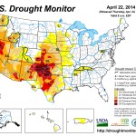
Weather systems moving in the upper-level westerly flow generated low pressure systems and surface fronts which moved across the contiguous United States (CONUS) this U.S. Drought Monitor (USDM) week. Two storm tracks resulted, with one moving across the northern tier states and the other from southern New Mexico, across the Gulf of Mexico coast, and up the East Coast. Above-normal rainfall was widespread across southern New Mexico, the Texas Trans Pecos, and the coastal Southeast. Below-normal precipitation dominated the rest of the country, with much of the Southwest again receiving virtually no precipitation. Weekly temperatures averaged above normal in the West and below normal in the East…
The Plains
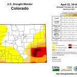
Drier-than-normal weather dominated the Plains this week and much of the last 6 months. A colder-than-normal winter and early spring have delayed agricultural activities; April 21 USDA reports indicated that the condition of winter wheat has declined in Kansas, with winter wheat condition rated poor to very poor for 32% of the crop in Kansas, 12% in Nebraska, and 4% in South Dakota. The USDA rated topsoil moisture conditions short or very short (dry or very dry) for 72% of Kansas, 54% of Nebraska, 50% of Colorado, and 23% of South Dakota. D0 expanded across eastern South Dakota to reflect dryness at the 30-day to 6-month time scales. Most of Kansas and Nebraska were already in moderate to extreme (D1-D3) drought, but an oval of D3 was added in central Kansas and D2 expanded eastward from there to reflect extreme low precipitation values at 30-90 days, as well as poor USDA soil moisture and crop condition reports. In southeast Colorado, D3-D4 expanded while the western edge of D0-D1 contracted. The D3 expansion in southeast Colorado bled into western Kansas…
The West
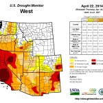
Parts of the coast and Cascades of Washington were wetter than normal this week, with stations receiving 3 inches or more of precipitation, and some locations reporting over 5 inches. An inch or two of precipitation was widespread over western Oregon, yet the week ended up drier than normal. Parts of the northern and central Rockies received an inch or more of precipitation, which was above normal in places. An upper-level system dropped a third of an inch to an inch of rain over southern New Mexico, which was above normal for the week. Otherwise, precipitation amounts were half an inch or less, with the southwestern third to half of the West receiving no precipitation. Mountain snowpack was below normal, except for the Washington ranges and northern and central Rockies, with continued warmer-than-normal temperatures accelerating the melting of the meager snowpack in the California Sierras.
In Arizona, livestock water tanks were dry so water hauling was an issue on ranges that don’t have water improvements with pumps, tanks, and pipes. D2-D3 expanded in southeast Arizona where stream levels continued to fall and evaporation was high. A very high fire danger and low precipitation at long (multi-year) time scales prompted the expansion of D1 in southwest Arizona and adjoining California and conversion of the S impact indicator to SL. In New Mexico, wetness in July and September 2013 masked longer-term dryness. October 2010-March 2014 was the third driest such 42-month period in the 1895-2014 record; it would be the driest if not for the July/September rains. Another dry week combined with this long-term dryness to expand D4 in northeast New Mexico. In Nevada, D3 expanded in Nye and adjacent Mineral counties, and the D1 donut hole was eliminated in southeast Nevada. The L impacts boundary along the Colorado-Utah-Wyoming boundary was pulled back where soil moisture deficits and short-term precipitation deficits indicated the SL timescale squeezing the L impacts region.
D2 and D3 expanded in northern California and parts of southern Oregon, with D2 spreading along coastal Oregon up to Lake County where precipitation deficits and low streamflows were most significant. D4 expanded further in the San Francisco Bay area and across all of Monterey County. In California, the city of San Diego was proposing a water supply “level 1” status, and a small reservoir/water district in Riverside County was on the 30-90 day “watch” list for depleted supplies. The San Antonio Reservoir has been essentially dry through the entire winter and Nacimiento Reservoir was at 22% capacity. The City of Montague risks running out of drinking water by the end of summer and has requested that all outside watering be curtailed until further notice; this is the first time in over 80 years of water deliveries from the Montague Water Conservation District (MWCD) that this situation has occurred. Growers in Shasta Valley with the primary irrigation district (MWCD) were expected to have only enough irrigation water to irrigate what would equate to a single irrigation on about half of their acreage. Many growers in the Big Springs area have already started pumping water to irrigate field. Within 24 hours of when one grower started irrigating, two nearby domestic wells went dry. The frustration caused by the drought can be seen in a report by an observer in Siskiyou County: “Our snow pack is pathetic, rainfall is way below normal, (low) stream flows are running at 2-3 months ahead of normal depending on the area, well levels have dropped severely and many wells are dry in spring or have levels typical of late fall, surface water irrigation supplies are non-existent to extremely limited in many areas, and the situation is only getting worse daily (especially after 3 consecutive years of drought).” With the expansion of D1 across southeast California and southwest Arizona, this week marks the first time in the 15-year history of the USDM that 100% of California was in moderate to exceptional drought…
Looking Ahead
The NWS HPC 7-Day Quantitative Precipitation Forecast (QPF) calls for frontal-low pressure systems to bring an inch or more of precipitation across a large part of the country, stretching from the eastern and northern Great Plains to the Appalachians, with 3 inches or more across parts of the Midwest to Deep South. Another area of 2+-inch precipitation is projected for coastal Washington and Oregon, and parts of the northern Rockies, while the Southwest is expected to remain mostly dry. Temperatures for the April 24-30 period are predicted to be warmer than normal in the southern states ahead of the front, with colder-than-normal air from the north moving across the country behind the frontal systems.
The 6-10 day and 8-14 day outlooks indicate that an upper-level circulation pattern, consisting of a ridge over western North America and a trough over the east, is predicted to become entrenched during May 1-7, bringing colder-than-normal temperatures to the country east of the Rockies and warmer-than-normal temperatures to the West and Alaska. This period should be drier than normal for the Southwest and Great Plains into the Midwest, and wetter than normal across the Southeast, Ohio Valley, Northeast, and part of the Pacific Northwest. Southern Alaska is expected to be wetter than normal with northwest Alaska drier than normal.