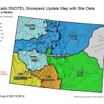
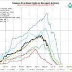
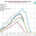
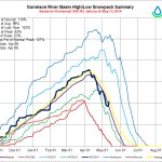
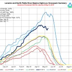
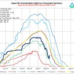
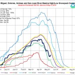
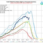

Click on a thumbnail graphic to view a gallery of snowpack data from the NRCS. What a difference one storm can make. Pay closer attention to the current SWE as a percent of average since the melt-out had started.
AMAZING impact from Mother's Day snowstorm on #Colorado #snowpack. Every river basin saw an increase! #cowx pic.twitter.com/rrxZDkgkHh
— Chris Spears (@ChrisCBS4) May 13, 2014
From 9News.com (Maya Rodriguez):
Sunny skies, climbing temperatures and mountain snow: it’s a combination that could signal a coming thaw this weekend. For those who live near the rivers fed by spring runoff, it is now a time to be vigilant, according to meteorologist and Lyons resident Greg Berman…
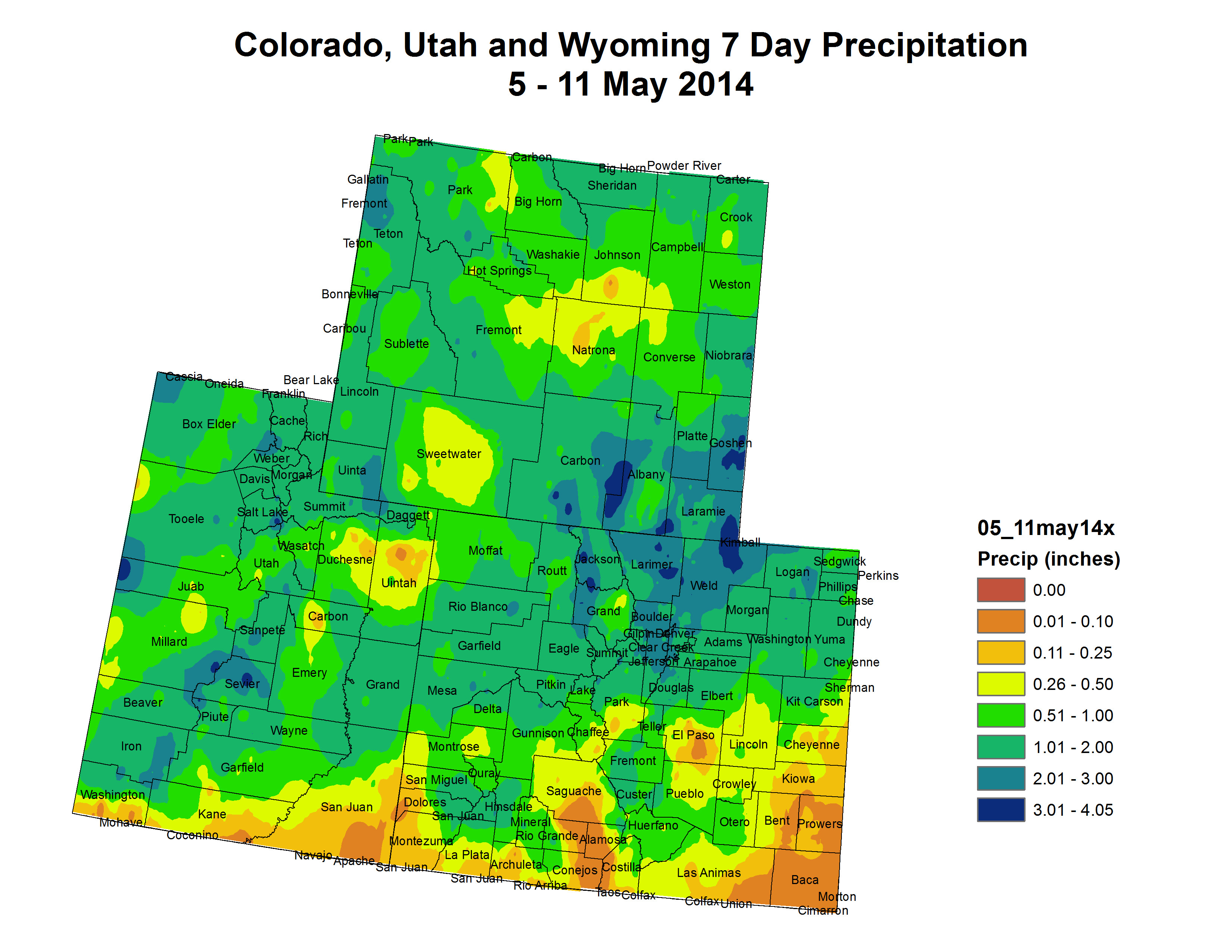
After this past weekend’s winter weather, the snowpack in Colorado is high. The National Weather Service said it is at 136 percent of normal for the Upper Colorado Headwaters, 143 percent for the North Platte and Laramie Basin and 145 percent for the South Platte.
One of the tributaries of the South Platte River is the St. Vrain River, which runs right through Longmont. It is an area that is scarred when it comes to high water and officials are already taking precautions.
“Our staff is periodically moving into a daily regimen where they are traveling up and down the river, looking at any signs of high water coming up, debris catching up on bridges and those kinds of things,” Longmont’s Director of Public Works and Natural Resources Dale Rademacher said…
One of the other unknown factors in all this is the topography itself. It has changed since last year’s flooding, and that could also mean changes this year’s spring runoff, including what areas may see the most impact, something that may not be clear until it happens.
From the Estes Park Trail-Gazette (David Persons):
“It was extremely wet,” said John Gulliksen, who gathers information locally for the National Weather Service. “It’s as wet as I’ve ever seen (for this time of year). I couldn’t push the snow very far or lift it to throw it.”
The numbers support Gulliksen.
According to his instruments, this two-day snowstorm dumped just over a foot (12.4 inches; ) of snow on the town. The 22-year average for snowfall in May in Estes Park is 6.9 inches; .
“This is pretty significant for May considering the amount,” Gulliksen added. “We do get snow in May but usually we get most of it in March and April. This year was an exception.”
Of course a late, wet snow is not exactly what Front Range officials want to hear. They are already weary of a swift, sudden snowmelt that could bring flooding back to the Front Range area which is still recovering from last September’s record-setting event…
Area snowfall totals from the National Weather Service for the May 11-12 snow event:
Allenspark, 23.5 inches; Bailey, 9.5 inches; Bergen Park, 12 inches; Black Hawk, 16.8 inches; Breckenridge, 10.9 inches; Broomfield, 6.2 inches; Castle Pines, 6 inches; Cheesman Reservoir, 7 inches; Conifer, 16 inches; Eldorado Springs, 11 inches; Elizabeth, 7 inches; Evergreen, 13 inches; Federal Heights, 6 inches; Fort Collins, 6.9 inches; Four Corners, Larimer County, 29 inches; Genesee, 16.6 inches; Greeley, 2.8 inches; Green Mountain Reservoir, Summit County, 8 inches; Highlands Ranch, 7 inches; Hugo, 3.5 inches; Karval, 2 inches; Ken Caryl, 7.8 inches; Lafayette, 4.5 inches; Littleton, 5.2 inches; Nederland, 16.5 inches; Northglenn, 8.1 inches; Pinecliffe, 15.1 inches; Pingree Park, 28 inches; Silver Plume, 16.8 inches; Thornton, 4.3 inches; Thurman, 6 inches; Virginia Dale, 16 inches; Westminster, 6.7 inches; Wheat Ridge, 5.3 inches.