
Click here to go to the Western Water Assessment Climate Dashboard. Here’s an excerpt:
Highlights
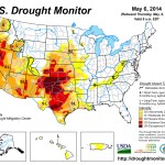
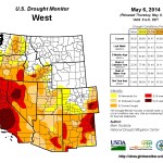
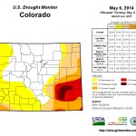
April was generally drier than average across the region, with few mountain areas seeing above-average precipitation, in contrast with previous months. The second week of May brought heavy precipitation to many parts of the region. As of May 13, snowpack conditions are similar to one month ago, with near-normal to above-normal SWE in Wyoming, northern and central Colorado, and northern Utah, and below-normal SWE in central and southern Utah and southern Colorado. The May 1 spring-summer streamflow forecasts slipped a little from the April 1 forecasts, though still calling for most forecast points in Wyoming and northern and central Colorado to have above-average or much-above-average spring runoff. Most forecast points in south-central and southwestern Colorado, and in Utah south of the Wasatch Front, are expected to have below-average or much-below-average runoff. Watersheds in the northern Front Range of Colorado most affected by the floods last September still have well-above-normal SWE. There is an elevated potential for snowmelt flooding given the large snowpacks and sediment-impacted stream channels. The emergence of an El Niño event in the next several months looks increasingly likely, with atmospheric and oceanic conditions consistently moving in that direction.
One thought on “The latest briefing from Western Water Assessment is hot off the presses”