
Thanks veterans for your service.
Happy Memorial Day
Thanks veterans for your service.

Thanks veterans for your service.

The City of Westminster, Colorado will be hosting the American Water Works Association, Water Distribution System Workshop from 8:00 a.m. – 5:00 p.m. on May 29, 2014.
The workshop’s overarching theme is Condition Assessment and Rehabilitation of Raw Water Delivery and Potable Water Distribution Systems and will include presentations and demonstrations of the latest industry technologies and upcoming regulatory requirements.
Participants will have an opportunity to attend presentations, participate in discussions, and witness demonstrations of industry leading technology, while earning 0.60 – 0.65 Training Units.
Agenda: http://rmsawwa.net/files/PDF/Workshops/WDS_Workshop_Agenda.pdf
To register for this class – click on link below:
Contact: Mike Middleton
Email: mike.middleton@ingeniumengineers.com
Phone: 720-515-8023
More Info: https://www.regonline.com/waterdistributionsystemworkshop2014
Location Details
Westminster Municipal Service Center
6575 West 88th Avenue
Westminster CO 80031
More infrastructure coverage here.

From the Albuquerque Journal (Kathaleen Roberts):
“El Agua es Vida: Acequias in Northern New Mexico” merges art, science and culture at the Maxwell Museum of Anthropology at the University of New Mexico. Based on a multidisciplinary study conducted by UNM, New Mexico State University, New Mexico Tech and Sandia National Laboratories, the exhibition will be up through May 31, 2015.
Acequia irrigation and agriculture created the northern New Mexico landscape we see today.
Unique to New Mexico – except for parts of southern Colorado and Texas – acequias originated in Spain. Spanish explorers brought them to the state in 1539, curator Devorah Romanek said.
Every colonial settlement that took root between 1600 and 1847 required the construction of ditches to direct water for crops and livestock. These hand-dug, gravity-fed trenches lure mountain snowmelt through the state’s narrow furrows and valleys and into community fields, orchards and gardens.
Before acequias veined the landscape, Pueblo, Apache and Navajo people developed their own irrigation systems as part of their farming methods. They also based their water management on community responsibility and participation.
About 42 percent of acequia-carried water recycles back into the aquifer, feeding the state’s rivers, Romanek said. These handmade ditches play a vital environmental role in a state where water is an increasingly scarce and precious resource.
“So it’s really the best way to manage the water here in New Mexico,” she explained. “And it also has these incredible cultural and traditional ties.”
The show features artwork and 130 objects relating to the digging and maintaining of acequias, as well their end products in farming and cooking.
If you go
WHAT: “El Agua es Vida: Acequias in Northern New Mexico”
WHEN: Through May 31, 2015
WHERE: Maxwell Museum of Anthropology, University of New Mexico
HOW MUCH: Free. Call 277-4405 or visit maxwellmuseum.unm/edu
From The Pueblo Chieftain (Chris Woodka):
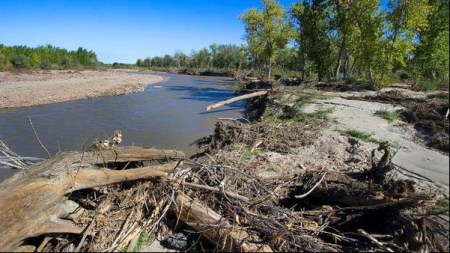
Fountain Creek is littered with logs, uprooted cottonwoods and debris from high flows in September. All aimed at Pueblo and the Lower Arkansas Valley. In fact, many are in Pueblo right now.
The Fountain Creek Watershed Flood Control and Greenway District Friday came to the realization that debris from the September downpour has not been removed from the creek, raising the possibility of increased damage if flooding occurs this year.
Unlike 2013, this summer could be wet. The Climate Prediction Center is calling for more moisture in Colorado; that could mean rain over large areas near Colorado Springs and the Black Forest that burned last year.
“Trees are staged everywhere,” said John Chavez, stormwater coordinator for El Paso County.
Removing the trees is expensive and there isn’t much money to do it. El Paso County is eligible for federal flood relief money, while Pueblo County is not.
Richard Skorman, a member of the Fountain Creek board, said people may not realize the danger that still exists.
“There was so much effort right after the fire,” he said.
Pueblo Councilwoman Eva Montoya, who chairs the Fountain Creek board, acknowledged there still are large trees in the Fountain Creek channel through Pueblo that could clog things during a big downpour.
Larry Small, the executive director of the district, said he observed many downed trees as well as erosion along Fountain Creek in northern Pueblo County.
Last month, he directed the Colorado Department of Transportation to remove trees it had stacked just downstream of the bridge at Fountain. The state has been slowly removing the trees.
“I think it’s important for people to realize the communities are working together, because this affects everybody,” she said.
More Fountain Creek coverage here.

From The Pueblo Chieftain (Chris Woodka):
The bull’s-eye for the state’s municipal water gap is centered over the Denver south metro area, which continues to boom in population.
Last week in Pueblo, the Colorado Water Conservation Board took a couple of actions that could keep that growth from sucking up water supplies from the rest of the state. The CWCB approved more than $100 million in loans to help water districts and some farmers in the area increase storage in Chatfield Reservoir and to expand a pipeline that will make their systems more efficient.
“There is a significant commitment to moving forward,” South Metro Water Authority Executive Director Eric Hecox told the CWCB Thursday. Representatives of various member districts filled the meeting room at the Pueblo Convention Center. The South Metro group includes 14 water districts that primarily rely on non-renewable Denver Basin groundwater to serve 300,000 people.
In a 2007 study, the group identified the Arkansas and Colorado river basins as areas where future pipelines might bring more water to the communities south of Denver. In recent years, other efforts to consolidate and boost resources have been identified, at least delaying more costly plans to import water.
One of those ways is a $145 million plan to add 20,600 acre-feet of storage accounts in Chatfield. The reallocation project to use the flood-control reservoir for supply storage has been in the works 20 years.
The CWCB approved $84 million in loans to the Centennial, Castle Pines and the Castle Pines North water and sanitation districts, as well as the Center of Colorado (Park County) and the Central Colorado (agricultural wells between Denver and Fort Morgan) water conservancy districts. For the urban users, the new accounts will allow greater ability to stretch existing supplies. For the agricultural users, it could mean turning on some of the wells that were shut off nearly a year ago.
The CWCB also approved $25 million to help four districts buy and expand the East Cherry Creek Valley Pipeline. Those districts are Cottonwood, Inverness, Parker and Pinery. The ECCV pipeline is a $147 million project to improve distribution for 10 districts in Douglas and Arapahoe counties, and is part of the Water Infrastructure and Supply Efficiency Project. That project also allows the districts to use excess capacity in Aurora’s Prairie Waters Project to capture and redistribute return flows from Denver water and Aurora.
One of the components also includes Parker Reservoir, which provides additional storage for some WISE participants.
More CWCB coverage here.
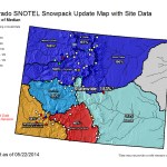


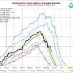
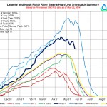

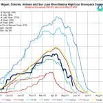

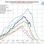
This is the time of year when snowpack numbers do not tell the story well. Also, as you can see above, the statewide map does not contain data from many stations.
The runoff has started all over the state so it’s more fun to watch the slope of the melt-out on the basin high/low graphs. The data in the graphics above do not reflect the recent wet upslope storm system that hit northeastern Colorado.
The southern basins were close to complete melt-out on May 22.
The May peaks in snow water equivalent also occurred in the record water year 2011.