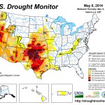
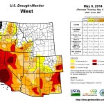
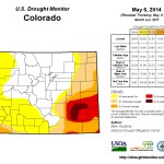
Click on a thumbnail graphic for a gallery of drought data from the US Drought Monitor.
Click here to go to the US Drought Monitor website. Here’s an excerpt:
The Plains
After good rains last week across parts of the northern Plains, dryness followed this week across most of eastern South Dakota, Nebraska and Kansas. Unseasonably cool weather continues to delay impacts thus far as 30-90 day deficits (25-75% of normal across the region) are starting to mount considerably for many parts of these states heading into summer. This has led to some changes this week in the form of expanding D1-D2 in eastern Nebraska as well as in the southern Panhandle out west. D1 also expanded in southeastern South Dakota, although some trimming of D0 on the northernmost flank of D0 in eastern South Dakota is also noted this week as they have been wetter than those counties in the southeast. Kansas continues to set the southern edge of the intense drought that seems to be waking up and pushing rapidly north along with warmer temperatures. A large expansion of D3 now covers nearly the entire southern half of Kansas and D4 is slowly pushing north out of Oklahoma. Soil moisture and groundwater levels are hurting well in front of the peak demand season as the cumulative impacts of such an intense multi-year drought are already glaringly evident, and it’s only early May. Precipitation totals on the year are running just 25-50% of normal, or worse, for many locales across southern Kansas.
The story is even bleaker in the southern Plains, where the heat and drought described above for Kansas are even more pronounced and entrenched across western Oklahoma and much of Texas as well. Expansion has begun to happen in earnest now that Mother Nature has turned up the furnace, which will do the landscape no favors with summer not here yet. Expansion of D2-D4 is noted across western Oklahoma and all changes in Texas are for the worse this week as well, with expansion of D0-D4 found statewide and D3 and D4 covering large portions of southern, central, north-central and the Panhandle of Texas. Streamflow and groundwater levels are hurting given the long duration and sustained intensity of this drought, which is now going on close to four years. Winter wheat has also been hard hit by hard freezes and the more recent triple-digit heat. Lack of range and pasture land, as well as fire, are the other main impacts already being reported early this year.
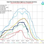
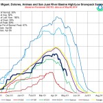
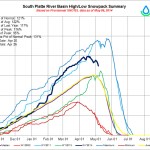
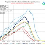
The West
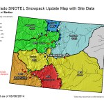
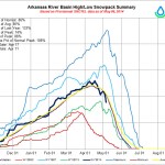
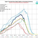
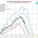
Most of the West remains in status quo after a relatively dry but warmer than normal week. For the drought-affected regions, the general lack of snow pack and water equivalent totals (as reported by USDA-NRCS) leaves a lot to be desired, with many locations falling at, or below, 50% of normal, and many areas have already melted out that shouldn’t have at this time of year. As the dry season settles in and demand peaks, water supplies will quickly follow suit as many in the region have already turned their attention to what the monsoon or potential El Niño may bring, knowing that the tap is about to go dry.
Some minor changes were made this week, with some slight expansion of D1 in extreme northeastern Colorado, where the drought in the Plains continues to slowly push westward toward the Front Range of the Rockies. Farther west and north, a late-season push of moisture brought some recovery to year-to-date totals in western Idaho, leading to some minor improvement of D0-D2 there.
Looking Ahead
Over the next 5 days (May 8-13), the National Weather Service is calling for a system to potentially bring some relief to the Pacific Northwest along with parts of the central Rockies and Front Range. Heavy precipitation is possible in northeastern Colorado and in the Nebraska Panhandle along with heavier, but spottier, totals expected in a band running north to south from Minnesota, western Iowa, western Missouri, eastern Kansas, eastern Oklahoma, western Arkansas and parts of north-central and southern Texas along with southern Louisiana as well. In addition, above-normal rains appear to be likely for Mississippi and northern Alabama along with the western reaches of the Tennessee Valley, northern Georgia and the extreme western counties in the Carolinas. As for temperatures, below-normal readings (5 to 10 degrees) are expected over roughly this same time period for the northern Plains, central/northern Rocky Mountain states, Idaho and parts of the Intermountain Basin region. The opposite is forecast for parts of all states east of the Mississippi River, except for Florida, with readings expected to run 3 to 9 degrees above normal.
The 6-10 day (May 13-17) and 8-14 (May 15-21) day outlooks are both consistent in showing a greater likelihood of above-normal temperatures across the West and below-normal temperatures east of the Mississippi River valley as well as the Great Lakes and Gulf Coast region, including coastal Texas. As for precipitation, below-normal rainfall is more likely across western Alaska, much of the West (not as likely in the Pacific NW), the central and southern Great Plains and the Mississippi Valley and over into the Southeast as well. Above-normal precipitation is likely only in the Northeast and New England regions, with lower chances stretching south into the northern Mid-Atlantic region.