
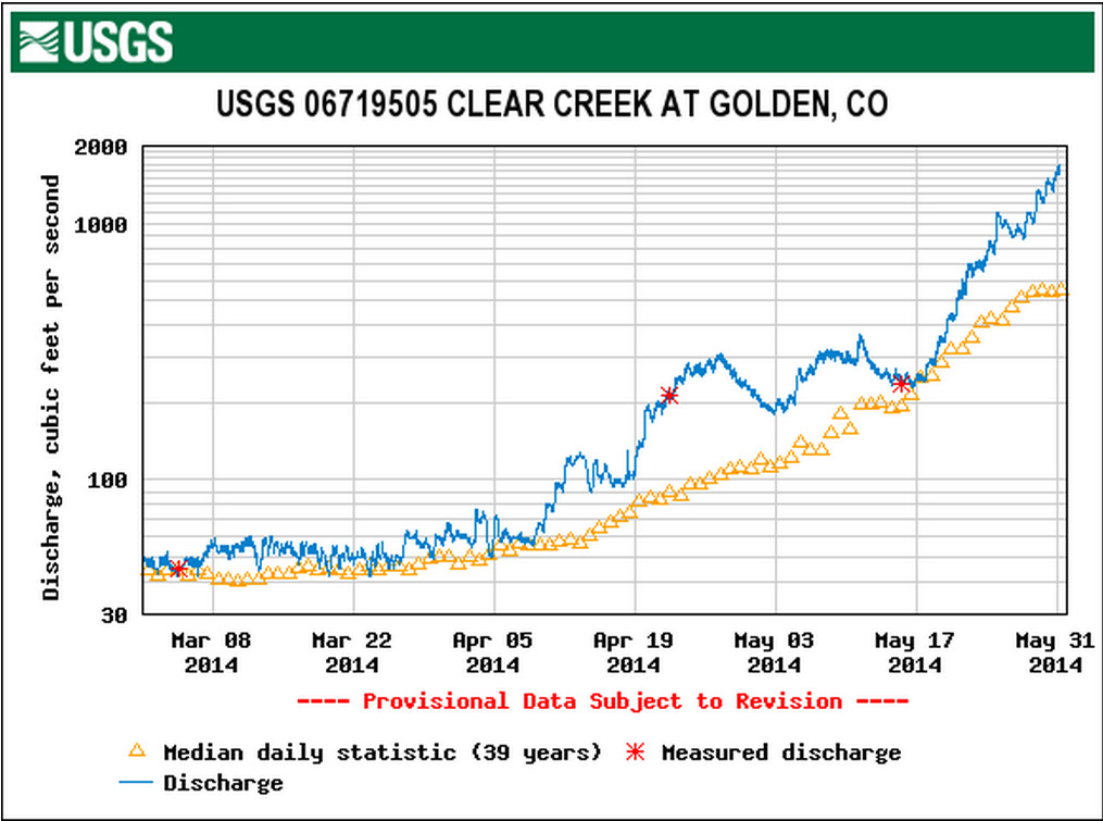
Clear Creek is roaring towards the South Platte River this morning. From email from USGS’s Water Watch:
Streamflow of 1660 cfs exceeds subscriber threshold of 200 at 2014-05-31 04:45:00 MDT
06719505 00060 CLEAR CREEK AT GOLDEN, CO
From The Pueblo Chieftain (Tracy Harmon):
Snowmelt is causing some high water levels in the Arkansas River prompting officials to close one section near Buena Vista and advise against use of the Royal Gorge section just west of Canon City. Colorado Parks and Wildlife and the Arkansas Headwaters Recreation Area closed a small section of the Arkansas River Friday until further notice due to safety concerns from a recently constructed diversion structure and boat chute. Water level in the 2-mile stretch from the Buena Vista Whitewater Park to Johnson Village, is running about 3,100 cubic feet per second.
The Royal Gorge section is running at about 3,700 cubic feet per second, according to the U.S. Geological Survey’s Parkdale gauge.
“The Royal Gorge section is not closed (to boaters) but it is currently under a high-water advisory. With a high-water advisory it is recommended that that section not be run (by commercial rafts) once flows go above 3,200 cubic feet per second,” said Abbie Walls, Division of Parks and Wildlife spokeswoman.
“Our No. 1 priority is public safety,” said Rob White, Arkansas Headwaters manager. “We know this is a popular area of the river, but until we can find a solution, we believe that this area is too dangerous for people to use.”
The good news for whitewater thrill-seekers is that there are plenty of other sections of the river open to rafting access including Browns Canyon just upstream of Salida and the Big Horn Sheep Canyon from Salida to Parkdale. Buena Vista’s Whitewater Park also is still open.
From The Pueblo Chieftain (Ryan Severance):
The Arkansas River in Pueblo is running high and fast but it’s far from creating flood concerns, according to the National Weather Service.
The river is running about 6.27 feet high and at 3,200 cubic feet per second, according to measurement data taken Friday evening at the Pueblo Dam.
“That’s running about 2 feet from even the minor flood stage level,” Larry Walrod, lead forecaster with the NWS Pueblo office, said. “The flow out of Pueblo Dam is controlled so they have the ability to control releases and they still have room for storage in case they need it.”
Walrod said river speeds would have to get up to around 5,500 cubic feet per second before flooding problems would arise.
While river water levels and speed are not at problematic levels for potential flooding, it should be noted that the river is still running higher and faster than usual.
“It’s generally good for the rafting industry but it poses a danger to people in or near the river,” Walrod said. “Water coming down in the flow is cold with temperatures in the 40s and 50s, which is shocking to the system and can take your breath away. Also, with the water running high for the first time since last summer, any debris from the winter gets swept into the current and that’s definitely hazardous.”
From the Glenwood Springs Post Independent (John Stroud):
“The water is big right now,” said Geoff Olson, co-owner at Blue Sky Adventures river outfitters in Glenwood Springs. “The rivers have been flowing about three times the normal rate for this time of year, and we’re expecting a good season all summer long.”
The high water levels mean rafting companies can run stretches of the Roaring Fork River that typically are too low for commercial rafting later in the season, Olson said.
It also means some good, early season whitewater activity along the stretch of the Colorado River from Grizzly Creek in Glenwood Canyon through No Name, which features some class 3 rapids this time of year, he said.
As of Friday afternoon, the Colorado River at Dotsero east of Glenwood Canyon was flowing at just over 15,000 cubic feet per second (cfs) with a gage depth of about 11.5 feet, according to the U.S. Geological Survey streamflow data website, at http://www.waterdata.usgs.gov.
The Colorado River at that location has been rising steadily over the last week, from less than 10,000 cfs and a depth of about 8.5 feet on May 23.
Likewise, the Colorado River below the confluence with the Roaring Fork River in Glenwood Springs was running at 21,200 cfs Friday afternoon, up from around 12,000 cfs at this time last week. The depth in the wider downstream river channel is pushing 10 feet.
The Roaring Fork River itself was running at more than 5,300 cfs just above the confluence in Glenwood Springs on Friday, while the stream depth was pushing 6 feet. That was up from about 2,500 cfs and a depth of 4.5 feet a week ago…
As it stands, the snowpack in the Colorado River Basin is more than 200 percent of normal for this time of year, boosted by late-season storms over the last two weeks, she said.
As of Friday, just 54 percent of the basin snowpack had melted.
“So, we’re only about halfway done,” Hultstrand said. “In a normal year, we usually have about 77 percent of the snowpack melted by this time. It’s definitely melting pretty fast out there now.”
From the Glenwood Springs Post Independent:
Releases from Ruedi Reservoir are spiking to make room for runoff and to help accommodate endangered fish on the Colorado River near Grand Junction.
The U.S. Bureau of Reclamation boosted the releases from the Ruedi Dam by 50 cubic feet per second Friday morning, and it planned another bump of 50 cfs at 8 p.m.
The combined new releases will boost the total releases from the dam to about 370.
“We’ve seen a new forecast come in, and runoff inflows to Ruedi are increasing more than what was forecast back on May 1,” said Reclamation Bureau spokeswoman Kara Lamb. “This is not atypical, especially in years when we continue to add snowpack through the month of May, as has happened this year.”