
Click on a thumbnail graphic for a gallery of drought data from the US Drought Monitor
Click here to go to the website. Here’s an excerpt:
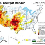
Summary
This US Drought Monitor week was dominated by a weather system that moved across the Rockies, into the Southern Plains and Midwest and through the South and Mid-Atlantic. The system brought damaging wind, hail, and tornadoes. On May 21, a widespread area of Colorado was impacted by an associated supercell thunderstorm which spawned multiple tornadoes and dumped golf ball-sized hail on Colorado Springs. This storm continued eastward dumping much needed precipitation in the Southern Plains through the end of the Drought Monitor week…
The Plains
Locally heavy rain came to the Southern Plains during the Drought Monitor week. Areas from New Mexico and Texas up into western Nebraska benefitted. Texas experienced widespread improvements in Exceptional (D4), Extreme (D3), and Severe (D2) Drought largely throughout the central part of the state and the Panhandle. Moderate Drought (D1) and Abnormal Dryness (D0) also decreased, mainly in the eastern part of the state. Oklahoma likewise experienced an improvement mostly in Exceptional (D4) and Extreme (D3) Drought throughout the center of the state. Conversely, limited improvement in drought conditions in western Nebraska was more than offset by degradation of Extreme (D3), Severe (D2), and Moderate Drought (D1) and Abnormal Dryness (D0) in the central and eastern part of the state…
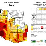
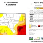
The West
Little precipitation fell west of the Rockies this week. Conditions remain very dry. Areas of Extreme Drought (D3) expanded slightly in western New Mexico, while precipitation in eastern New Mexico alleviated small areas of Exceptional (D4), Extreme (D3), and Severe (D2) Drought there. Northeast Colorado experienced an improvement in Moderate Drought (D1). Statewide, California, at 75%, and New Mexico, at 72%, lead the nation in percent of pasture and rangeland in Poor or Very Poor conditions. The rest of the West remained unchanged. Wildfires remain a problem in parts of the West. According to the US Forest Service, the current large incidents are all in California, Arizona, and Alaska. So far this year nationwide, there have been 23,339 fires that have burned 710,011 acres which is below the 10-year average (2004 – 2014 average, year to date, is 28,631 fires and 1,139,433 acres according to the National Interagency Fire Center)…
Looking Ahead
During the May 28-June 2, 2014 time period, precipitation is expected across the Northern and Central Plains and into the Southeast. At the same time, below normal temperatures are expected along the Mid-Atlantic Coast and in the states along the western Gulf of Mexico. Above normal temperatures are expected in the center of the country and along the West Coast.For the ensuing 5 days (June 3-7, 2014), the odds favor normal to above-normal temperatures across the entire contiguous U.S. and southern Alaska, with the exception of the western Gulf of Mexico Coast. Below-normal temperatures are favored in northern Alaska and along the aforementioned area around the Gulf of Mexico. Above-normal precipitation is likely from the Central and Northern Plains, through the Midwest and into the Mid-Atlantic and Southeast. Below-normal precipitation is expected from the Southern Plains through most of the West. Alaska is likely to see above-normal precipitation to the north and below-normal precipitation in the south.
Meanwhile, below is the Seasonal Drought Outlook map from the Climate Prediction Center.

Lake Mead is ending May at its lowest level for this time of year since they filled it in the 1930s: http://t.co/H7PeSC5jyf #ColoradoRiver
— jfleck (@jfleck) May 29, 2014