
From CBSDenver4.com:
The mountain snow is melting and it looks like Colorado’s white winter in the high country will bring good news for residents along the Front Range. Denver Water thinks Dillon Reservoir will fill to capacity for the first time in years.
It was the end of March last year when Denver Water put in Stage 1 water restrictions as Lake Dillon was only 65 percent full. As on Monday it’s at about 85 percent full and it’s actually being drained to get ready for more melting snow, which will mean even more water.
“It’s always a balancing act with our reservoirs across the state — Dillon in particular. We want to ultimately keep it full so people can enjoy recreation on the reservoir, but we have to be really conscious too as to what happens below the reservoir,” Stacy Chesney with Denver Water said.
With the snowpack well above average surrounding the largest reservoir that sends water to Denver, officials have been planning all winter to let some go.
“We’ve been proactively releasing water into the river below to create that room to help reduce any risk of flooding that could happen later in the season,” Chesney said.
But officials from Denver Water are keeping an eye on the snowpack with the hope of having full reservoirs for the first time since July of 2011.
“At this point we do expect that our reservoirs will fill and we hope that customers will continue that wise water use and not overuse water and follow our watering rules which will start on May 1,” Chesney said.
What many people in the high country are going to be watching is a layer of dust on the Western Slope that has sat on the snow for nearly a month. That, along with rain and warm temperatures over the last week, helped rush the melt over the past few days.
From Steamboat Today (Scott Franz):
This week, the persistent snow in the mountains just outside Steamboat Springs is reminiscent of the impressive snowpack of 2011, when the Yampa River overran Bald Eagle Lake and caused the youth minister at the Steamboat Christian Center and his family to evacuate their parsonage.
Is spring 2014 another 2011 in the making? It’s unlikely, according to a hydrologist with the National Oceanic and Atmospheric Administration who keeps close tabs on the Yampa River Basin.
Ashley Nielson confirmed that the total volume of water that flowed down the Yampa in 2011 beginning on April 1 and continuing through July 31 was the highest on record. And this year’s snowpack doesn’t measure up.
“We do see a 10 percent chance the peak flow on the Yampa will go over flood stage, but it’s totally dependent on what kind of spring we have and how that snow comes off,” Nielson said Monday. “There’s a lot less snow than what we had in 2011.”
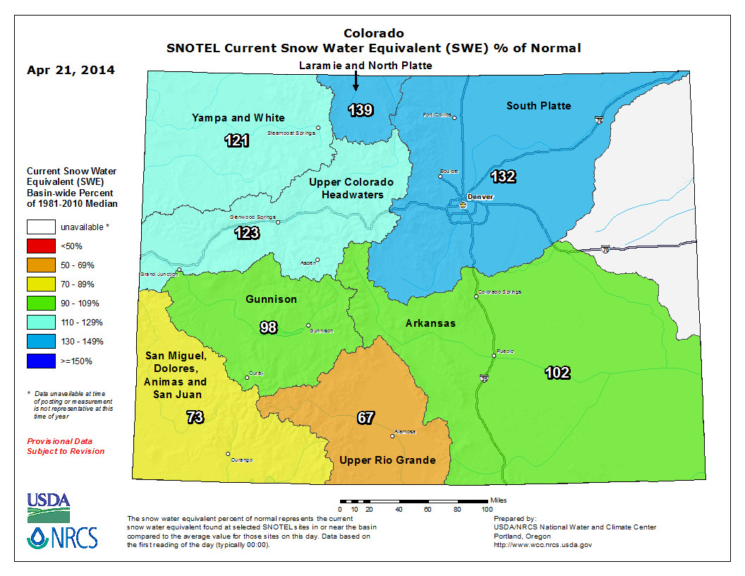
The Natural Resources Conservation Service is reporting that the snow at the top of Buffalo Pass is currently 134 inches deep, which is down from 149 inches April 14, and the snow water equivalent is 112 percent of median. That compares to a record 180 inches of snow depth that stood at 130 percent of average in 2011. At the west summit of Rabbit Ears Pass on Monday, the snow water equivalent was 150 percent of median compared to 157 percent April 23, 2011…
Still, the hydrograph for this week closely mirrors 2011, Nielson agreed, when low elevation runoff peaked on April 23. Nielson’s office is forecasting that the Yampa will shoot up Wednesday at about 1,900 cfs, then slip back to the range of 1,000 to 1,200 cfs through the end of the month when a cold front is expected to apply the brakes. It’s very typical, she said, for the Yampa to rise steeply in late April as snow melts suddenly from the valley floor and lower slopes.
So you had a lot of #snow this year? Check this out! 196" near Buffalo Pass NE of Steamboat Springs on April 1. pic.twitter.com/tA3GefmCkh
— NWS Grand Junction (@NWSGJT) April 22, 2014