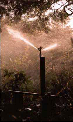
After years of delay, state and federal agencies this month confirmed they will clean the water by building a $15 million treatment plant — a project that had the goal of restoring fish habitat. The plant is a key step in a federal Superfund cleanup that has dragged on for 32 years. But fish are still out of luck.
Local town leaders want to divert the cleaned water for people, frustrating the agencies and those who want fish to return to the creek. It’s a case of how Colorado’s population growth and development boom are intensifying competition for water.
“It isn’t ideal,” said David Holm, director of the Clear Creek Watershed Foundation. “Would it be better if we had a deal to ensure ample in-stream flow in North Clear Creek? Yes. But who can make in-stream flow be part of the deal?”
The mining towns-turned-gambling meccas Black Hawk and Central City have asserted that, under Colorado’s water appropriation system, they can use senior water rights that they own to tap the cleaned creek. Black Hawk plans to build thousands more hotel rooms, hiking and biking trails, a reservoir and, possibly, a golf course — all requiring more water.
Colorado’s water plan will probably include additional conservation measures from cities and industrial users. That’s what members of the state’s Interbasin Compact Committee agreed to at a meeting May 20.
The specifics are still being worked out, but the added conservation could save 400,000 acre-feet of water. That’s nearly three times the capacity of Horsetooth Reservoir, outside Fort Collins.
Colorado’s nine water basins presented their final plans for water management at the meeting in Sterling. Those will be incorporated into the statewide plan…
“We heard a lot about support for environmental and recreational needs. And then we did hear a lot from people about the need to increase conservation targets,” said [Kate McIntire].
Other major themes include improving efficiency in cities, opposition to taking more water from the Western Slope for Front Range use, and improving agricultural conservation and efficiency.
The water plan does not come up with a solution to the contentious topic of diverting water from the Western Slope to the Front Range. Rather, it includes a framework that will be the basis for future discussions on diversions. Basins on the western side of the state are opposed to new diversions, while those on the eastern side say they will be necessary because of a growing Front Range population.
Abby Burk works on river conservation for the Rocky Mountain regional office of the Audubon Society. She said the comments show the priorities of citizens in the state.
“So the public has spoken loud and clear. Coloradans want healthy resilient rivers and more efficient use of our existing water,” said Burk.
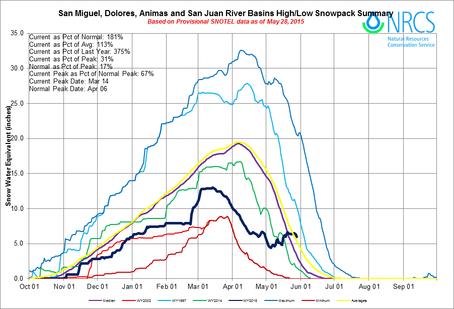
San Miguel, Dolores, Animas, and San Juan Basin High/Low graph May 28, 2015 via the NRCS From the Cortez Journal (Jim Mimiaga):
Local meteorologist Jim Andrus reported that so far this year, southwest Colorado has received 6.52 inches of rain, with 2.41 inches falling this month alone.
“That puts us at 141 percent of normal for the year,” he said.
In May 2.41 inches have fallen so far, he said, and the 30-year average is .83 inches.
“May has been extraordinary, and is almost three times the norm for precipitation,” Andrus said. “It is the wettest May since at least 1998 when I began keeping records.”
The moisture has produced significant snow above 10,000 feet in the La Plata and San Juan Mountains. The additional moisture has bumped up low snowpack levels in the region as well.
According to the Natural Resource Conservation Service, combined snowpack levels for the Dolores, Animas, San Miguel, and San Juan river basins is at 86 percent of normal, up from 61 percent of normal in February.
The recent rainy trend is because of a low-pressure ridge that guided in moisture from the Pacific, Andrus said.
“It replaced a high-pressure ridge that we had all winter, blocking the storms and giving us a dry winter,” he said…
Durango has experienced its wettest May in at least 16 years, and more rain may be on the way.
By Tuesday, 2.9 inches of precipitation had fallen at Durango-La Plata County Airport. Records at that location date to 2000. The second-wettest May came in 2011, when 1.29 inches fell.
Last year saw only 0.68 inches of May precipitation.
One year ago the region [souteastern Colorado] was gripped by a multi-year drought that created conditions similar to those of the Dust Bowl in the 1930s.
Grass fires were becoming a common scene and widespread dust storms were a frequent visitor.
One year later it’s a completely different story after a month of record rain essentially wiped out the drought.
At 7 p.m. Friday the city broke the previous record of 8.1 inches of precipitation, after getting an official total of .22 inches Friday, the National Weather Service said. The previous record was set in 1935.
“What’s been really interesting is how many days it’s rained – it wasn’t just a few big rains,” said Nolan Doesken, the state climatologist at Colorado State University’s Colorado Climate Center.
It is unusual that Colorado Springs’ wettest month came outside of the typical southern Colorado wet season of July and August, according to Doesken…
This spring, considered the months of March through May, also is the fourth wettest spring on record, with a total of 9.84 inches of precipitation, according to National Weather Service statistics from Thursday.
While the rain is falling at lower elevations, the snow is piling up atop Pikes Peak.
On Friday, the drifts were 15 feet high on the west and east sides of the Summit House.
The Pikes Peak Highway is open to mile marker 15, the Double Cut between Glen Cove and Devil’s Playground. That leaves four miles to the summit uncleared. Under ideal conditions, crews hope to have the road open to Devil’s Playground early next week and to the 14,115-foot summit in about 10 days…
Although this is an El Niño year, which typically results in warm oceanic temperatures that impact precipitation, National Weather Service meteorological technician Randy Gray emphasized that the location of these sea surface temperatures has caused the abnormal increase in moist weather systems.
“The location of the warm temperatures along the equator has helped steer these systems our way,” Gray said…
This increased precipitation in Colorado Springs is part of a multi-state weather pattern that has resulted in unusually high amounts of rain from southern California into Colorado, parts of Wyoming, Nebraska, Kansas, Oklahoma and Texas, according to Doesken.
“This has been a total drought-buster for the southern area,” Doesken said.
Lest the residents of sunshine states forget: This rain, we needed it, even if California needed it just a bit more. It may save us yet from a June spent choking on smoke. For now, the wildfire risk in much of the Intermountain West is not above normal, though that may change in July and August in the Northern Rockies, when wildfire season usually gets going there.
The rains won’t save us from all of our drought-related ills, however. That still takes snow, and this winter was not generous with it throughout much of the West. Snowpack usually peaks in the region around April 1, but this year at that time, thanks to a balmy March and an unremarkable dusting, it was rapidly melting out.
Nearly two months later, snowpacks look misleadingly good in parts of Colorado and New Mexico, where conditions for this time of year are above average thanks to late snow in the mountains at a time it would usually be waning. The new snow doesn’t make up for its lack earlier in the year, nor the long, slow melt-out that would contribute to deep soil moisture.
That said, the rains and snows of May have improved soil moisture at shallow depths. They’ve also been good for streamflows in some places, and beneficial for overall water supply, according to the Colorado River Basin Forecast Center, by reducing demand early in irrigation season.
The expected inflow into major reservoirs is still expected to be low, however. Projections for inflow into Lake Powell from April to July remain at just 42 percent of average. And as we reported recently, Lake Mead has hit a record low. It’s just three feet above the level which will trigger mandatory curtailments in Arizona and Nevada. Meanwhile, Elephant Butte, one of the major reservoirs on the Rio Grande, is only 20 percent full.