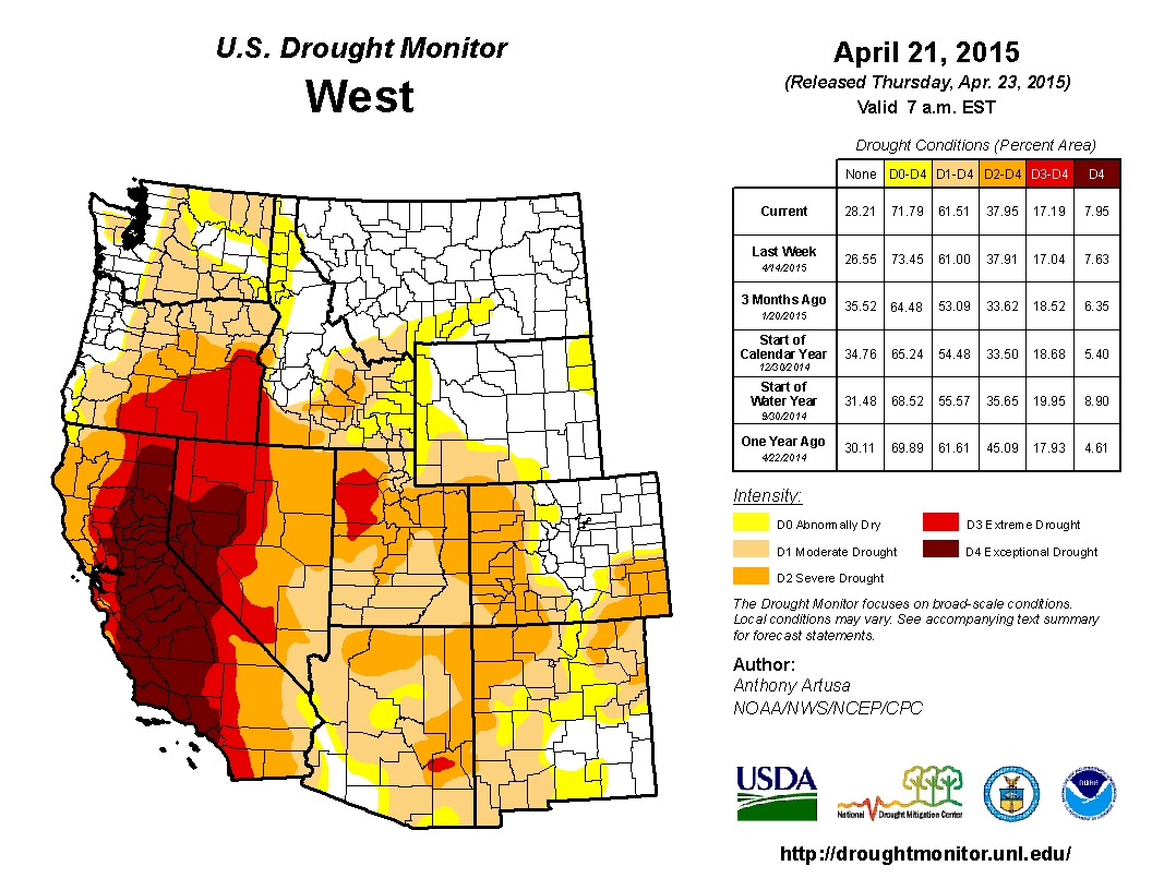
Click here to go the US Drought Monitor website. Here’s an excerpt:
Summary
During the past 7-days, heavy rain (2 inches or greater) fell across portions of the southern Plains, the lower Mississippi Valley, and the Southeast. The heavy rain was associated with the approach and passage of several upper-air troughs and frontal systems. Light precipitation (up to 0.5-inch) was reported across many areas west of the Continental Divide. Daytime high temperatures early in the week only reached the 30s and 40s in the eastern Dakotas/western Great Lakes region. By the weekend, high temperatures in the 40s were common across the Great Lakes region and Northeast, as winter-like conditions were slow to give way to lasting spring warmth…
The Plains
In North Dakota, rains this past week were very spotty. Conditions were variable, with some reports of wet soil and machinery stuck in the mud, and other reports of inadequate vegetation for livestock. For this week, the only modification made to the drought depiction was to slightly expand moderate drought (D1) westward in south-central North Dakota to include eastern Stutsman, eastern Logan, and eastern McIntosh Counties. One area that bears monitoring in the next few weeks for possible deterioration to severe drought (D2) is Cass and Richland Counties, in the extreme southeast part of the state.
In eastern and central South Dakota, field work and corn planting is ramping up quickly this week, especially in the eastern part of the state, and field reports indicate dry topsoil conditions. A fairly large area of severe drought (D2) was introduced in central and eastern South Dakota. One agricultural impact is winter wheat winterkill (due in part to dry overall conditions, lack of protective snow cover, and a lack of moisture so far this spring). Other small grains that were planted this spring have been slow to emerge, or uneven in emergence, due to dry conditions. Alfalfa fields also experienced winterkill and/or frost damage. Moderate drought (D1) was expanded across north-central and extreme southeastern portions of South Dakota, where recent rains missed. The National Agricultural Statistics Service (part of USDA) soil moisture reports indicate South Dakota is 69 percent Short or Very Short, which is the third worst in the Nation.
In northeastern Nebraska, longer-term precipitation deficits extend back to (at least) the start of the current Water Year (October 1, 2014). Recent rainfall has also missed this region. Therefore, a 1-category deterioration was made to the depiction, from abnormal dryness to moderate drought (D0 to D1), for the Counties of Antelope, Pierce, Knox, and Cedar. In southwestern Kansas, there were welcome rains and cooler conditions, but the only 1-category upgrade was made to the counties of Meade and Clark. Other areas received enough precipitation to at least offset further degradation.
In western and central Oklahoma, heavy rain (widespread 2-4 inches, locally in excess of 10 inches) fell during the past week prompting 1-category improvements in some areas. In Texas, rain fell mostly where it was needed this week, resulting in lots of 1-category improvements across the state. Improvements in the Dallas-Fort Worth area are based on reservoir recovery, while in the San Antonio area, they are based on aquifer recovery and various objective indicators. Reservoirs are lagging behind in central Texas. Short-term improvements were also rendered to the drought depiction in the Panhandle region…
The West
In eastern New Mexico during the past several days, widespread 1-2 inch rain amounts (locally greater) fell in the area from Clayton to Tucumcari, Santa Rosa, and Clovis. There were reports of excellent soaking rains, with little runoff into arroyos and small streams. A rancher from San Miguel County reported soil moisture down to 3 feet, with significant green-up compared to the past several years. Factors such as these prompted the removal of severe drought (D2) from Quay County, and moderate drought (D1) from southern Quay County and portions of adjacent counties. Following are USGS stream flow reports for New Mexico (expressed as percent of historical average for the current Water Year, October 1, 2014 to present). Stream flows in the Gila basin range between 98-104 percent; for the headwater tributaries of the Pecos River basin 106-138 percent, and for the lower Pecos River basin 84-166 percent. Stream flows in the Animas River of the San Juan River basin are about 123 percent of average; for the headwater tributaries of the Canadian River basin 78-126 percent, for the mid- to lower- part of the Canadian River basin 19-41 percent, and for the Canadian River mainstem near 21 percent. In the Rio Grande basin above Albuquerque, stream flows range between 88-129 percent of average; the Rio Grande below Taos Junction Bridge 116 percent, and the Jemez River near Jemez 92 percent of average.
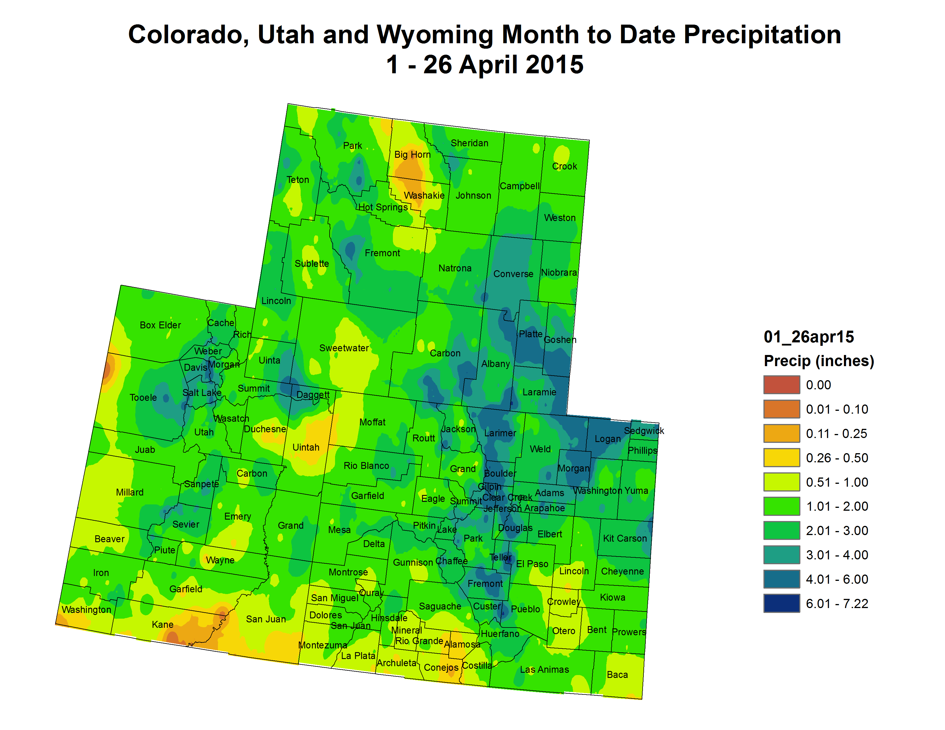
Relatively small-scale revisions were made to the depiction in both Colorado and Utah. The largest change was a 1-category improvement (from D2 to D1) across eastern sections of Utah, and adjacent western sections of Colorado.
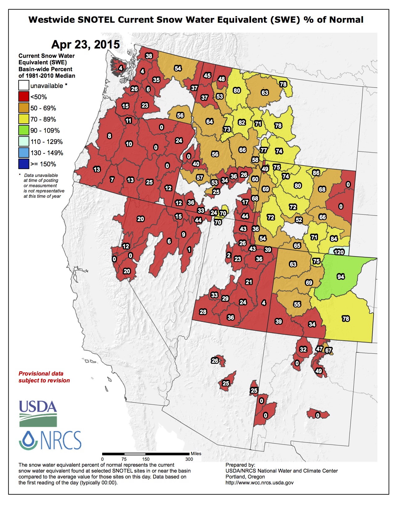
In southwestern Idaho over the past few weeks, there has been a robust green-up in the Owyhee River basin. However, it appears to be short-lived, as the snow-dominated streamflow peak has, or is now, passing through the region. In addition, prospects for ample precipitation within the next two weeks are low. As a result, widespread 1-category deterioration was rendered to the drought depiction across much of Idaho. In Washington, it’s been much drier than usual during the last month, especially in the lower Columbia Basin. As a result, the Yakima Bureau of Reclamation announced their mid-month forecast is expecting pro-ratable water users to receive only 54 percent of their water allocation. Reservoirs are being tapped earlier than normal (normal is late June), since snow melt is not adequate for regional needs, in addition to stretches of warm, dry weather. Accordingly, severe drought (D2) was expanded from north-central Oregon into south-central Washington, and moderate drought (D1) was expanded across the Blue Mountains (Garfield and Asotin Counties) in the extreme southeast part of the state, where the few Snotel stations that are there, are snow-free. In northeastern Oregon, severe drought (D2) was expanded across Umatilla and northern Baker Counties. Abnormal dryness (D0) was expanded to include the Oregon Coast, due to significant short-term precipitation deficits. Moderate drought (D1) was expanded westward across the western slopes of the Oregon Cascades, and much of the Willamette Valley. In south-central and southeastern Montana, abnormal dryness (D0) was modestly expanded to reflect the increasingly dry conditions.
Little if any precipitation fell across the state of California during the past 7-days, with the exception of moderate to locally heavy precipitation (0.5-3.0 inches) over north-central portions of the state, including the Sierras. The heavy precipitation will aid in green-up, but is expected to have very little impact on the long-term drought. No alterations were made this week to the California drought depiction…
Looking Ahead
For the upcoming 5-day period, April 30-May 4, much of the contiguous United States is expected to receive little if any precipitation. Fairly localized exceptions may include the Virginias and parts of the Corn Belt, where 0.5-2.0 inches is predicted.
For the 6-10 day period, May 5-9, there are elevated odds of above-median precipitation across most areas between the Rockies and Appalachians, as well as for southern Florida. There are elevated odds of below-median precipitation for much of the Pacific Northwest and part of the Southeast.