Snowpack news: April to June forecast for inflows to Lake Powell = 52% of avg. #ColoradoRiver

From InkStain (John Fleck):

The April-July runoff forecast into Lake Powell, on the Arizona-Utah border, is just 52 percent of the long term mean, according to new numbers out today from the Colorado Basin River Forecast Center.

That is roughly 1.3 million acre feet less water flowing into Lake Powell than the forecast of just a month ago, the result of a hot, dry March. That means at the end of said runoff period, Powell will be roughly 13 feet lower than it would have been otherwise, according to my half-assed amateur calculation (danger, danger, journalist doing math! – the pros at the Bureau of Reclamation will give us a more reliable number next week).

From the Pagosa Springs Sun (Renita Freeman):

The Natural Resources Conser- vation Service (NRCS) reported that the San Juan River Basin was at 51 percent of median on April 1, com- pared to 63 percent in the March 1 report. Snowpack reports generated by the National Resource Conserva- tion Service (NRCS) show that the San Juan Basin snowpack was down 19 percent from last month.

According to data provided by SNOTEL, the report listed three measurements. The first was the Upper San Juan, with snow depth of 37 inches, and a current median of 47 percent compared to 74 per- cent last year. Vallecito, with a snow depth of 22 inches, was listed at 53 percent as compared to 90 percent median for last year, and Wolf Creek Summit, with a snow depth of 43 inches, was listed at 56 percent as compared to 76 percent median last year.

According to the Colorado Water Supply Outlook report on the United States Department of Ag- riculture site, “Forecasts of any kind are not perfect. Streamflow forecast uncertainty arises from three primary sources: (1) uncer- tain knowledge of future weather conditions, (2) uncertainty in the forecasting procedure, and (3) er- rors in the data. The forecast, there- fore, must be interpreted not as a single value but rather as a range of values with specific probabilities of occurrence.”

From the Estes Park Trail-Gazette (Pamela Johnson):

Snowpack in the South Platte River basin sits at 89 percent of average, while the Upper Colorado basin is recording 78 percent of average at automated sites. Numbers from sites that are measured manually will be released within the next few days, but cumulative snowpack figures have remained below average over the past months…

In Loveland, only 0.37 inches of precipitation fell in March, or 23 percent of average, according to Wendy Ryan, assistant state climatologist at Colorado State University. Over the past three months, 2.24 inches was recorded in Loveland, or 85 percent of normal. During the same time, Loveland’s temperatures were 2.4 degrees above average, according to Ryan…

Brian Werner, spokesman for Northern Water, said storage levels in the Colorado-Big Thompson Project and other local reservoirs remain at all-time highs.

From 9News.com (Whitney Wild):

Coming off the snowiest February on record, the National Weather Service calls March a dud. The dry spell melted the statewide snowpack from 87 percent of average at the end of February to 69 percent as of Thursday.

“When we talk about snowpack, and we talk about drought, and we talk about how much rain is going to fall, the state doesn’t act all in sync,” NWS meteorologist Bob Glancy said…

In southwest Colorado, the reservoirs are below average and well-below capacity. North of the metro-Denver area, reservoirs are above average but slightly below capacity.

Meanwhile here’s a report about the low snowpack from Bruce Finley writing for The Denver Post:

Colorado’s mountain snowpack is running low — around 69 percent of average — raising concerns about low stream flow during summer and potential strain on water supplies. A relatively hot, dry March took a toll, melting away snowpack from 87 percent at the end of February. The latest data under review by the federal Natural Resources Conservation Service survey team on Thursday showed statewide snowpack at 69 percent of average, with snowpack in southwestern Colorado basins dropping to 55 and 58 percent of average.

In the closely watched Colorado River Basin, snowpack was measured at 76 percent, the early data show. The South Platte River Basin, which supplies metro Denver and northeastern Colorado, had snowpack at 88 percent of average. The Arkansas River Basin was at 83 percent of average…

Water storage in reservoirs statewide measured at 90 percent of last year’s level on March 1. Federal hydrologists had yet to compile the latest water levels in reservoirs.

#Drought news: Drought intensifies over Colorado

Click here to go to the US Drought Monitor website. Here’s an excerpt:

Summary

Rain was heaviest across the nation’s mid-section as well as parts of the Northwest and eastern U.S., while intensifying dryness was noted in the Southeast and from the northern Great Lakes and Upper Midwest to the central and southern Pacific Coast, including the Great Plains. Much-above-normal temperatures accelerated crop-water demands on the Plains and further reduced already-dire mountain snowpacks over much of the West. Dryness also increased in the Northeast, though lingering cold mitigated the impacts of the precipitation deficits somewhat…

Central Plains

Dry, unseasonably warm weather maintained or worsened drought over the central Plains for a second consecutive week. With sunny skies and temperatures approaching or topping 80°F from southeastern Colorado into Kansas and central Nebraska, drought conditions remained or intensified. In particular, pronounced dryness over the past 6 months (30-50 percent of normal) across south-central and northern Nebraska supported the expansion of Moderate (D1); the Standardized Precipitation Index (SPI, a station-based drought indicator) over the same time period in these locales averaged -1.0 to -1.7 (D1-D3 equivalent) indicating conditions may rapidly deteriorate if rain fails to materialize soon. Elsewhere, light showers (generally less than half an inch) in eastern portion of the region afforded little – if any – drought relief…

Northern Plains

Light to moderate rainfall on the northern-most Plains was in sharp contrast to increasing dryness and drought farther south. Locally more than an inch of rain in North Dakota was sufficient to prevent further expansion of Abnormal Dryness (D0) or Moderate Drought (D1), though precipitation over the past 6 months remained well short of normal (30-60 percent of normal). Farther south, above-normal temperatures (daytime readings in excess of 80°F) and a lack of much-needed rain resulted in expansion of D1 in southern South Dakota; precipitation in South Dakota’s new D1 area averaged 25 to 50 percent of normal over the past 6 months, which equated to a Standardized Precipitation Index (SPI, a station-based drought indicator) equivalent over the same time period of D1. Likewise, soil moisture rankings remained unfavorably low over much of southern and eastern South Dakota, and streamflows – which benefited from recent snow melt – have begun to drop rapidly…

Southern Plains and Texas

Worsening drought in the north contrasted with heavy rain and drought reduction in the south and east. Across western Oklahoma and northern Texas, sunny skies, daytime highs approaching or topping 90°F, and occasionally gusty winds caused Moderate (D1) to Extreme (D3) Drought to intensify. Soil moisture and streamflow rankings remained at or below the 5th percentile in the southern Plain’s core drought areas, while the satellite-derived Vegetation Health Index indicated rapidly declining conditions from the Texas Panhandle into northern Oklahoma. Farther east, locally more than an inch of rain afforded some relief from drought in northeastern Oklahoma. Farther south, additional assessment from the field indicated some reduction of Abnormal Dryness (D0) was warranted near Victoria, Texas, while drought coverage and intensity remained unchanged northwest of Austin as reservoir levels struggled to rebound due to a pronounced long-term drought impacts…

Western U.S.

The overall trend toward drought persistence continued, with drought intensification noted over the eastern Great Basin and central Rockies. The west continued to cope with much-above-normal temperatures, further depleting already-dire snowpacks and reducing spring runoff prospects over much of the region.

In the north, additional Pacific moisture and weekly average temperatures up to 10°F above normal resulted in moderate to heavy showers (1-4 inches, locally more) in orographically favored portions of the Cascades and northern Rockies. However, plentiful water-year precipitation (since October 1) in the Northwest remained in sharp contrast to virtually non-existent snowpacks, with the snow-water equivalents less than 25 percent of normal (locally less than 10 percent) across Oregon as well as southern and northwestern Washington. The lack of snow maintained concerns for spring and summer water supplies despite the generally favorable 2014-15 water year.

Across the Great Basin and Four Corners States, drought intensified in northern portion of the region but remained unchanged elsewhere. In particular, Severe Drought (D2) expanded over northeastern Nevada, where water-year precipitation (since October 1) has averaged less than 50 percent of normal the northwest; the Standardized Precipitation Index (SPI, a station-based drought indicator) over the same time period in this location averaged -1.3 to -2.0 (D2-D4 equivalent) indicating conditions will likely deteriorate further if rain and mountain snow fail to materialize soon. In Colorado, D2 was increased as low SNOTEL percentiles, low snowpack, and high temperatures are having an impact in the state; snow-water equivalent (SWE) in the state’s D2 areas are now consistently at or below the 10th percentile, and locally below the 5th percentile. Meanwhile, conditions remained unchanged in the southern Four Corners Region, where Water Year precipitation has been generally higher than locales farther north.

In California, there were no changes to this week’s depiction as the state entered a fourth consecutive year of drought. With temperatures averaging more than 10°F above normal for the week, snowpacks continued to dwindle; as of April 1, the state’s total snowpack stood at a meager 5 percent of average. Indicative of the virtually non-existent snowpack, streamflows have dropped into the 5th percentile or lower over much of California. In addition, the 2014-15 Water Year has ended on an abysmal note, with precipitation over the past 30 days totaling a mere 10 percent of normal or less from Redding southward. Even with some precipitation in the forecast across central and northern California, any rain and mountain snow – while welcomed – would likely do little to improve the state’s dire drought prospects…

Looking Ahead

Rain from the lower and middle Mississippi Valley into New England will contrast with mostly dry conditions across the Southeast and Gulf Coast as well as from the Plains into the Southwest. A strong cold front will bring temporary relief from unseasonable warmth over the Plains, though above-normal temperatures will return by the weekend. Rainfall associated with the front will be light on the Plains, and generally confined to central and northern-most portions of the region. However, rain will intensify as the cold front marches east, with 5-day totals of 1 to 3 inches possible from the northern Delta into the Ohio Valley and Northeast. In contrast, dry conditions are expected from the Carolinas to the immediate Gulf Coast. Out west, some showers and high-elevation snow will overspread the Northwest during the weekend, while the Southwest and Four Corners Region remain dry. The NWS 6- to 10-day outlook for April 7–11 calls favorably cooler- and wetter-than-normal weather from the Pacific Coast into the Great Basin, including California. Likewise, wetter-than-normal weather is also expected from the Mississippi Valley and Gulf Coast States into the Northeast. In contrast, drier-than-normal conditions will prevail across the Rockies and Great Plains. East of the Rockies, abnormal warmth over southern portions of the Corn Belt and Mid-Atlantic States will contrast from cooler-than-normal weather across the northern Great Lakes and New England.

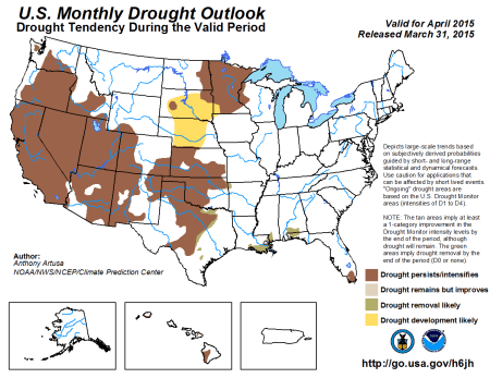
Here’s the monthly drought outlook for April from the Climate Prediction Center.

April drought outlook via the Climate Prediction Center

Reclamation Signs Lease of Power Privilege with the Northern Water Hydropower Water Activity Enterprise for Granby Dam in Colorado #ColoradoRiver

Granby Dam via Reclamation

Here’s the release from the Bureau of Reclamation (Patience Hurley):

Reclamation announced today that Great Plains Regional Director Michael J. Ryan signed a Lease of Power Privilege for Granby Dam located near Granby, Colorado.
The LOPP authorizes Northern Water Hydropower Water Activity Enterprise development of a 1.2 megawatt hydropower plant at the base of Granby Dam, a west-slope feature of the Colorado-Big Thompson Project. The project utilizes a “run of dam” design that harnesses water releases from Granby Dam to generate power and provide a clean, renewable source of energy to north-central Colorado.

The final environmental assessment and Finding of No Significant Impact are available at http://www.usbr.gov/gp/ecao/nepa/granby_hydropower.html or you may request a paper copy by contacting Patience Hurley at (701) 221-1204.

More Colorado-Big Thompson Project coverage here.

Video: #onedayindenver about Denver’s water supply & its future