West Clear Creek cleanup: “But who can make instream flow part of the deal?” — David Holm

Clear Creek watershed map via the Clear Creek Watershed Foundation

From The Denver Post (Bruce Finley):

After years of delay, state and federal agencies this month confirmed they will clean the water by building a $15 million treatment plant — a project that had the goal of restoring fish habitat. The plant is a key step in a federal Superfund cleanup that has dragged on for 32 years. But fish are still out of luck.

Local town leaders want to divert the cleaned water for people, frustrating the agencies and those who want fish to return to the creek. It’s a case of how Colorado’s population growth and development boom are intensifying competition for water.

“It isn’t ideal,” said David Holm, director of the Clear Creek Watershed Foundation. “Would it be better if we had a deal to ensure ample in-stream flow in North Clear Creek? Yes. But who can make in-stream flow be part of the deal?”

The mining towns-turned-gambling meccas Black Hawk and Central City have asserted that, under Colorado’s water appropriation system, they can use senior water rights that they own to tap the cleaned creek. Black Hawk plans to build thousands more hotel rooms, hiking and biking trails, a reservoir and, possibly, a golf course — all requiring more water.

More Clear Creek Watershed coverage here.

IBCC to increase conservation targets in the #COWaterPlan

watersprinkler

From KUNC (Stephanie Paige Ogburn):

Colorado’s water plan will probably include additional conservation measures from cities and industrial users. That’s what members of the state’s Interbasin Compact Committee agreed to at a meeting May 20.

The specifics are still being worked out, but the added conservation could save 400,000 acre-feet of water. That’s nearly three times the capacity of Horsetooth Reservoir, outside Fort Collins.

Colorado’s nine water basins presented their final plans for water management at the meeting in Sterling. Those will be incorporated into the statewide plan…

“We heard a lot about support for environmental and recreational needs. And then we did hear a lot from people about the need to increase conservation targets,” said [Kate McIntire].

Other major themes include improving efficiency in cities, opposition to taking more water from the Western Slope for Front Range use, and improving agricultural conservation and efficiency.

The water plan does not come up with a solution to the contentious topic of diverting water from the Western Slope to the Front Range. Rather, it includes a framework that will be the basis for future discussions on diversions. Basins on the western side of the state are opposed to new diversions, while those on the eastern side say they will be necessary because of a growing Front Range population.

Abby Burk works on river conservation for the Rocky Mountain regional office of the Audubon Society. She said the comments show the priorities of citizens in the state.

“So the public has spoken loud and clear. Coloradans want healthy resilient rivers and more efficient use of our existing water,” said Burk.

More IBCC — basin roundtable coverage here.

Snowpack/runoff news: May precipitation 290% of normal in Montezuma County #drought

San Miguel, Dolores, Animas, and San Juan Basin High/Low graph May 28, 2015 via the NRCS

From the Cortez Journal (Jim Mimiaga):

Local meteorologist Jim Andrus reported that so far this year, southwest Colorado has received 6.52 inches of rain, with 2.41 inches falling this month alone.

“That puts us at 141 percent of normal for the year,” he said.

In May 2.41 inches have fallen so far, he said, and the 30-year average is .83 inches.

“May has been extraordinary, and is almost three times the norm for precipitation,” Andrus said. “It is the wettest May since at least 1998 when I began keeping records.”

The moisture has produced significant snow above 10,000 feet in the La Plata and San Juan Mountains. The additional moisture has bumped up low snowpack levels in the region as well.

According to the Natural Resource Conservation Service, combined snowpack levels for the Dolores, Animas, San Miguel, and San Juan river basins is at 86 percent of normal, up from 61 percent of normal in February.

The recent rainy trend is because of a low-pressure ridge that guided in moisture from the Pacific, Andrus said.

“It replaced a high-pressure ridge that we had all winter, blocking the storms and giving us a dry winter,” he said…

Durango has experienced its wettest May in at least 16 years, and more rain may be on the way.

By Tuesday, 2.9 inches of precipitation had fallen at Durango-La Plata County Airport. Records at that location date to 2000. The second-wettest May came in 2011, when 1.29 inches fell.

Last year saw only 0.68 inches of May precipitation.

From CBS Denver (Chris Spears):

One year ago the region [souteastern Colorado] was gripped by a multi-year drought that created conditions similar to those of the Dust Bowl in the 1930s.

Grass fires were becoming a common scene and widespread dust storms were a frequent visitor.

One year later it’s a completely different story after a month of record rain essentially wiped out the drought.

From The Colorado Springs Gazette (Ellie Mulder):

At 7 p.m. Friday the city broke the previous record of 8.1 inches of precipitation, after getting an official total of .22 inches Friday, the National Weather Service said. The previous record was set in 1935.

“What’s been really interesting is how many days it’s rained – it wasn’t just a few big rains,” said Nolan Doesken, the state climatologist at Colorado State University’s Colorado Climate Center.

It is unusual that Colorado Springs’ wettest month came outside of the typical southern Colorado wet season of July and August, according to Doesken…

This spring, considered the months of March through May, also is the fourth wettest spring on record, with a total of 9.84 inches of precipitation, according to National Weather Service statistics from Thursday.

While the rain is falling at lower elevations, the snow is piling up atop Pikes Peak.

On Friday, the drifts were 15 feet high on the west and east sides of the Summit House.

The Pikes Peak Highway is open to mile marker 15, the Double Cut between Glen Cove and Devil’s Playground. That leaves four miles to the summit uncleared. Under ideal conditions, crews hope to have the road open to Devil’s Playground early next week and to the 14,115-foot summit in about 10 days…

Although this is an El Niño year, which typically results in warm oceanic temperatures that impact precipitation, National Weather Service meteorological technician Randy Gray emphasized that the location of these sea surface temperatures has caused the abnormal increase in moist weather systems.

“The location of the warm temperatures along the equator has helped steer these systems our way,” Gray said…

This increased precipitation in Colorado Springs is part of a multi-state weather pattern that has resulted in unusually high amounts of rain from southern California into Colorado, parts of Wyoming, Nebraska, Kansas, Oklahoma and Texas, according to Doesken.

“This has been a total drought-buster for the southern area,” Doesken said.

From the High Country News (Cally Carswell):

Lest the residents of sunshine states forget: This rain, we needed it, even if California needed it just a bit more. It may save us yet from a June spent choking on smoke. For now, the wildfire risk in much of the Intermountain West is not above normal, though that may change in July and August in the Northern Rockies, when wildfire season usually gets going there.

The rains won’t save us from all of our drought-related ills, however. That still takes snow, and this winter was not generous with it throughout much of the West. Snowpack usually peaks in the region around April 1, but this year at that time, thanks to a balmy March and an unremarkable dusting, it was rapidly melting out.

Nearly two months later, snowpacks look misleadingly good in parts of Colorado and New Mexico, where conditions for this time of year are above average thanks to late snow in the mountains at a time it would usually be waning. The new snow doesn’t make up for its lack earlier in the year, nor the long, slow melt-out that would contribute to deep soil moisture.

That said, the rains and snows of May have improved soil moisture at shallow depths. They’ve also been good for streamflows in some places, and beneficial for overall water supply, according to the Colorado River Basin Forecast Center, by reducing demand early in irrigation season.

The expected inflow into major reservoirs is still expected to be low, however. Projections for inflow into Lake Powell from April to July remain at just 42 percent of average. And as we reported recently, Lake Mead has hit a record low. It’s just three feet above the level which will trigger mandatory curtailments in Arizona and Nevada. Meanwhile, Elephant Butte, one of the major reservoirs on the Rio Grande, is only 20 percent full.

Couple of panos at Dinosaur Nat’l Monument happy 100th Birthday! [October 4]

Click here to go to the Dinosaur National Monument Wikipedia page.

Lake Powell May inflows = 400,000 acre-feet #ColoradoRiver

Glen Canyon Dam -- Photo / Brad Udall
Glen Canyon Dam — Photo / Brad Udall

From InkStain (John Fleck):

Lake Powell is ending May with a surface elevation above 3,596 feet above sea level, four feet above the projection when the month began. That’s an extra 400,000 acre feet of water. Lake Mead, less dependent on weather and more dependent on releases from upstream, is nevertheless a foot above its projections, an elevation above 1,076.

The result is a forecast of more than 5 million acre feet of April-July runoff into Lake Powell, up from a forecast of just 3 million acre feet just a month ago. That is still well below the long term mean of just above 7 maf for April through July, but given the slim margins facing water managers right now the bonus water provides a crucial boost.

Before the storms hit, the Bureau of Reclamation forecast showed Lake Powell flirting with a key elevation threshold – elevation 3,575 come Jan. 1. The 2007 reservoir operation guidelines set that as a trigger point that would require water managers to hold more water upstream and reduce deliveries to Lake Mead. That would have meant a lot less water being sent downstream to Lake Mead beginning in October, setting off a cascade of decisions that could have triggered a shortage declaration in the Lower Basin as early as next Jan. 1…

With an extra 4 feet of water in Powell as of today, and more likely because of our “miracle May”, a 2016 shortage is looking far less likely, though we won’t know for sure until the next round of model results come out after the first of the month. My back-of-the-envelope calculations suggest we’re still at risk of a 2017 shortage declaration, but the risk of one in 2016 has dropped dramatically.

More Colorado River Basin coverage here.

#Drought news: Southeastern Colorado reaps the benefits of May rainfall

Click on a thumbnail graphic to view the May 26 and May 5, 2015 statewide maps.

From The Pueblo Chieftain (Jon Pompia):

Southeastern Colorado, parts of which have suffered under heavy drought and very dry conditions since fall 2010, has benefitted immensely from the recent extended period of rainfall.

A Drought Monitor map released by the National Weather Service shows that with the exception of Baca and Prowers counties, and a small portion of Bent, Southeastern Colorado is now drought-free.

Still, Baca and Prowers are not classified as being under drought conditions but rather “abnormally dry.”

According to Paul Wolyn, a meteorologist with the National Weather Service in Pueblo, only one year ago, most of Southeastern Colorado was in an “extreme drought,” with parts of Otero, Crowley and Kiowa counties suffering under “exceptional drought,” the weather service’s most extreme and rare classification.

And just three months ago, most of Southeastern Colorado, as well as Las Animas County, was classified as being in a “severe” drought.

The start of the Southeastern Colorado drought can be traced back to fall 2010. While a NWS map from July 2010 shows the entire western half of the state drought-free, by December of that year, the drought in that same region had become moderate to severe, with Southeastern Colorado seeing the worst of these conditions.

Although there was some relief in 2012, things dried up again in 2013, with most of Southern and Southeastern Colorado designated as being in an extreme to exceptional drought by summer.

In 2014, a string of summer showers improved the picture somewhat before extended rains this spring moved Southeastern Colorado out of the drought classification.

Snowpack/runoff news

Click on a thumbnail graphic to view the Basin High/Low graph for your favorite river basin.

From The Colorado Springs Gazette (Chhun Sun):

With five days left in the month, Colorado Springs is less than half an inch from matching the rainfall total for the wettest May in the city’s history.

The Colorado Springs Airport received .26 inches of rain from 4 p.m. Tuesday to 10 p.m. Tuesday with no report of precipitation after that time, putting this month’s official rainfall total at 7.66 inches, said meteorologist Randy Gray of the National Weather Service in Pueblo.

That’s just .44 inches from the record of 8.1 inches, which was set in 1935.

“We’re keeping an eye on that record,” Gray said.

USGS: Evaluation of Groundwater Levels in the South Platte River Alluvial Aquifer, Colorado, 1953–2012

South Platte River Basin via Wikipedia

Here’s the abstract from the United States Geological Survey (Tristan P. Wellman):

The South Platte River and underlying alluvial aquifer form an important hydrologic resource in northeastern Colorado that provides water to population centers along the Front Range and to agricultural communities across the rural plains. Water is regulated based on seniority of water rights and delivered using a network of administration structures that includes ditches, reservoirs, wells, impacted river sections, and engineered recharge areas. A recent addendum to Colorado water law enacted during 2002–2003 curtailed pumping from thousands of wells that lacked authorized augmentation plans. The restrictions in pumping were hypothesized to increase water storage in the aquifer, causing groundwater to rise near the land surface at some locations. The U.S. Geological Survey (USGS), in cooperation with the Colorado Water Conservation Board and the Colorado Water Institute, completed an assessment of 60 years (yr) of historical groundwater-level records collected from 1953 to 2012 from 1,669 wells. Relations of “high” groundwater levels, defined as depth to water from 0 to 10 feet (ft) below land surface, were compared to precipitation, river discharge, and 36 geographic and administrative attributes to identify natural and human controls in areas with shallow groundwater.

Averaged per decade and over the entire aquifer, depths to groundwater varied between 24 and 32 ft over the 60-yr record. The shallowest average depth to water was identified during 1983–1992, which also recorded the highest levels of decadal precipitation. Average depth to water was greatest (32 ft) during 1953–1962 and intermediate (30 ft) in the recent decade (2003–2012) following curtailment of pumping. Between the decades 1993–2002 and 2003–2012, groundwater levels declined about 2 ft across the aquifer. In comparison, in areas where groundwater levels were within 20 ft of the land surface, observed groundwater levels rose about 0.6 ft, on average, during the same period, which demonstrated preferential rise in areas with shallow groundwater.

Approximately 29 percent of water-level observations were identified as high groundwater in the South Platte River alluvial aquifer over the 60-yr record. High groundwater levels were found in 17 to 33 percent of wells examined by decade, with the largest percentages occurring over three decades from 1963 to 1992. The recent decade (2003–2012) exhibited an intermediate percentage (25 percent) of wells with high groundwater levels but also had the highest percentage (30 percent) of high groundwater observations, although results by observations were similar (26–29 percent) over three decades prior, from 1963 to 1992. Major sections of the aquifer from north of Sterling to Julesburg and areas near Greeley, La Salle, and Gilcrest were identified with the highest frequencies of high groundwater levels.

Changes in groundwater levels were evaluated using Kendal line and least trimmed squares regression methods using a significance level of 0.01 and statistical power of 0.8. During 2003–2012, following curtailment of pumping, 88 percent of wells and 81 percent of subwatershed areas with significant trends in groundwater levels exhibited rising water levels. Over the complete 60-yr record, however, 66 percent of wells and 57 percent of subwatersheds with significant groundwater-level trends still showed declining water levels; rates of groundwater-level change were typically less than 0.125 ft/yr in areas near the South Platte River, with greater declines along the southern tributaries. In agreement, 58 percent of subwatersheds evaluated between 1963–1972 and 2003–2012 showed net declines in average decadal groundwater levels. More areas had groundwater decline in upgradient sections to the west and rise in downgradient sections to the east, implying a redistribution of water has occurred in some areas of the aquifer.

Precipitation was identified as having the strongest statistically significant correlations to river discharge over annual and decadal periods (Pearson correlation coefficients of 0.5 and 0.8, respectively, and statistical significance defined by p-values less than 0.05). Correlation coefficients between river discharge and frequency of high groundwater levels were statistically significant at 0.4 annually and 0.6 over decadal periods, indicating that periods of high river flow were often coincident with high groundwater conditions. Over seasonal periods in five of the six decades examined, peak high groundwater levels occurred after spring runoff from July to September when administrative structures were most active. Between 1993–2002 and 2003–2012, groundwater levels rose while river discharge decreased, in part from greater reliance on surface water and curtailed pumping from wells without augmentation plans.

Geographic attributes of elevation and proximity to streams and rivers showed moderate correlations to high groundwater levels in wells used for observing groundwater levels (correlation coefficients of 0.3 to 0.4). Local depressions and regional lows within the aquifer were identified as areas of potential shallow groundwater. Wells close to the river regularly indicated high groundwater levels, while those within depleted tributaries tended to have low frequencies of high groundwater levels. Some attributes of administrative structures were spatially correlated to high groundwater levels at moderate to high magnitudes (correlation coefficients of 0.3 to 0.7). The number of affected river reaches or recharge areas that surround a well where groundwater levels were observed and its distance from the nearest well field showed the strongest controls on high groundwater levels. Influences of administrative structures on groundwater levels were in some cases local over a mile or less but could extend to several miles, often manifesting as diffuse effects from multiple surrounding structures.

A network of candidate monitoring wells was proposed to initiate a regional monitoring program. Consistent monitoring and analysis of groundwater levels will be needed for informed decisions to optimize beneficial use of water and to limit high groundwater levels in susceptible areas. Finalization of the network will require future field reconnaissance to assess local site conditions and discussions with State authorities.

More South Platte River Basin coverage here.

Major Construction Set to Begin on WISE Water Project — South Metro Water Supply Authority

WISE System Map September 11, 2014

From email from the South Metro Water Supply Authority (Russ Rizzo):

Construction is set to begin on a regional water project that is a significant part of the South Denver Metro area’s plan to transition to a renewable water supply.

Western Summit Constructors, Inc. has been contracted to oversee design and construction of major infrastructure for the WISE (Water Infrastructure and Supply Efficiency) project. Construction will begin in Juneand continue into 2016, when water deliveries will begin.

WISE is a partnership among Aurora Water, Denver Water and the South Metro Water Supply Authority to combine available water supplies and system capacities to create a sustainable new water supply. Aurora and Denver will provide fully treated water to South Metro Water on a permanent basis. WISE also will enable Denver Water to access its supplies during periods when it needs to. All of this will be accomplished while allowing Aurora to continue to meet its customers’ current and future needs.

“This is a significant milestone in our long-term plan to transition to a renewable water supply,” said Eric Hecox, executive director of the South Metro Water, which represents 14 water providers comprising most of Douglas County and a portion of Arapahoe County. “With construction agreements now in place, we will break ground in coming weeks to begin connecting water systems throughout the Denver Metro area.”

Aurora’s Prairie Waters system will provide the backbone for delivering water from the South Platte when Aurora and Denver Water have available water supplies and capacity. The water will be distributed to the South Metro Denver communities through an existing pipeline shared with Denver and East Cherry Creek Valley Water and Sanitation District and new infrastructure that will be constructed over the next 16 months.

“By working together, the three major water entities serving the Denver Metro area have put the southern communities of Denver on a more secure and sustainable path while delivering benefits to the entire region as well as West Slope communities,” said Gov. John Hickenlooper. “The approach is a model for us to replicate as Colorado’s Water Plan is implemented.”

When WISE begins delivering water in 2016:

●The South Denver Metro area will receive a significant new renewable water supply;

●Denver will receive a new backup water supply;

●Aurora will receive funding from partners to help offset its Prairie Waters Project costs and stabilize water rates; and

●The West Slope will receive new funding, managed by the River District, for water supply, watershed and water quality projects.

South Metro Water and its 14 water provider members are executing a plan to transition to renewable supplies. The plan focuses on three areas: investments in infrastructure; partnership among local and regional water suppliers; and maximizing efficiency of existing resources through conservation and reuse.

The South Metro region has made tremendous progress over the past 10 years, reducing per capita water use by more than 30 percent and adding new renewable water supplies and storage capacity that have significantly decreased reliance on nonrenewable groundwater.

For details on the WISE project as well as South Metro Water’s plan to transition to renewable water supplies, visit http://www.southmetrowater.org/smwsa-projects/.

More WISE Project coverage here.

“Water is the foundation of life. What threatens that imperils us all” — NRDC

waterfromtap

From the Natural Resources Defense Council newsletter:

Today our country took one of its biggest steps ever to protect clean water with a new standard that restores safeguards to nearly two million miles of headwaters and streams and tens of millions of acres of wetlands.

Building on decades of successful water protections, the Clean Water Rule will defend sources of safe drinking water for one in every three Americans by clarifying protections that had come under challenge from some of the country’s biggest polluters.

The new rule is a victory for all of us, if we can keep it from being thwarted by its foes and their allies in Congress.

Republican leaders in the House and Senate have already teed up a showdown over this needed rule, a largely partisan battle that pits oil and gas companies, shopping center builders, Big Agriculture and others against the basic American right to clean water.

The Republican-led House sided earlier this month with the polluters.

We’re counting on the Senate to stand up for clean water.

For more than four decades, American waters have been protected by the Clean Water Act, passed by overwhelming Republican and Democratic majorities in both houses of Congress in 1972.

In recent years, though, this important law has come under withering attack by interests that stand to profit from weakening the protections the law provides.

In essence, these groups claim the Clean Water Act shouldn’t apply to vast reaches of streams and wetlands because these bodies of water are too remote, too small or too dependent on seasonal rains to count.

That, of course, is nonsense.

Even mighty rivers start small, taking on volume from wetlands and tributaries as water flows downhill.

Pollution at any point along the journey threatens all the waters downstream.

That’s why state and local officials, members of Congress, advocates for industry, agriculture, the environment and others, as well as members of the public at large, have asked the Environmental Protection Agency and the Army Corps of Engineers to clarify the reach of the Clean Water Act.

The agencies have participated in more than 400 meetings on the issue nationwide. Over just the past year, they’ve reviewed more than a million comments from people who depend on clean water for things like raising food, running their businesses, attracting tourism or fishing and hunting.

And here’s what they’ve found: 87 percent of the people who commented want the waters of America protected.

That’s exactly what the agencies have in mind with the Clean Water Rule, made final today.

Unless the polluters and their congressional allies get their way.

On May 12, the GOP-led House passed a bill to block the vital safeguards contained in the new Clean Water Rule — two weeks before the final rule was even issued.

The opponents didn’t need to see the final rule to vote against the measure, putting polluter profits first — and putting our drinking water at risk.

Similar legislation is pending in the Senate.

The Clean Water Rule, though, needs to go forward without further congressional obstruction or delay.

The rule’s protections will provide the country with up to $572 million worth of benefits every single year, the EPA estimates.

The wetlands and waterways this rule will defend help protect our communities from flooding. They filter industrial, agricultural and urban pollutants out of our water. They provide habitat for wildlife. And they help to recharge groundwater supplies.

Water is the foundation of life. What threatens that imperils us all.

We need our Senate to put our future first, put this pernicious legislation to bed and let the people who keep our water clean do the job we’re counting on them to do.

From email from American Rivers (Bob Irvin):

On Wednesday, thanks to the efforts of American Rivers and our partners and supporters, the Obama Administration released the Clean Water Rule, restoring protections to streams and wetlands that are drinking water sources for more than 1 in 3 Americans.

Few things are more fundamental to our health than clean water. You shouldn’t have to worry about pollution when you turn on the tap. This administration’s leadership in protecting our streams will benefit millions of Americans and our children and grandchildren.

Thank you for standing with American Rivers and speaking up for clean water. Because of your support, American Rivers was able to provide expert scientific analysis of the rule, educate key decision makers, and build a strong wave of public support nationwide.

The Clean Water Rule restores clear protection to 60 percent of the nation’s stream miles and millions of acres of wetlands that were historically protected by the Clean Water Act, but have lacked guaranteed safeguards for nearly a decade.

As we celebrate this victory we know our work isn’t done. Special interests and some members of Congress continue to try to dismantle the Clean Water Rule’s protections.

But we will do everything in our power to ensure these critical safeguards for our rivers remain. They are essential to the drinking water supplies for today’s communities, and future generations.

With your help, we will preserve this victory and build on our success, ensuring healthy rivers for all Americans nationwide.

More Environmental Protection Agency coverage here.

Can more plumbing save Colorado’s water? — The Colorado Independent #COWaterPlan

crocusbobberwyn

From The Colorado Independent (Bob Berwyn):

When Colorado’s tourism marketing gurus wanted to show the world what the state is all about, they used television spots evoking the powerful call of wild rivers — hikers gazing at waterfalls, anglers wading in still, dawn-lit waters and kayakers and rafters paddling through whitewater. But are those images more myth or reality?

Most of the state’s water is private property, under lock and key.

Thousands of diversions – canals and pipelines — move water to where it’s needed for crops, factories and drinking water. This intricately engineered plumbing system has fundamentally reshaped Colorado’s landscape. Water diversions allow millions of people to live in the semi-desert rain-shadow east of the Rockies, and enable vast emerald alfalfa fields to thrive in the otherwise dry sagebrush steppe of the Western Slope.
Colorado’s new water plan is in large part about deciding whether and when there will be new diversions, who will benefit and who will pay for them.

handwheelstraightcreekdillonbobberwyn

Colorado, by law and policy, has actively promoted water development for more than 100 years. Thousands of miles of streams and rivers have been dammed, diverted and polluted to provide water for factories, farms, cities, mines and oil and gas operations. As a result, Colorado’s environment has suffered.

dillondamspillwaybobberwyn

The evolving Colorado water plan talks about the importance of leaving waters in rivers, but finding the flexibility and “extra” water to account for environmental needs like native-Colorado-river fish won’t be easy.

streamgagetenmilecreekbobberwyn

Colorado, of course, is not alone. More than 30 percent of rivers in the United States are impaired or polluted. So much water is drawn from rivers that many no longer flow to the sea year-round. As a result, the extinction rate for freshwater animals like fish and mollusks is five time higher than for land animals.

moffattunneldiversionbobberwyn

The first draft of the new Colorado water plan recognizes that leaving water in rivers and streams is important, but it’s not clear whether the final version of the plan, due by the end of this year, will include any specific goals for for maintaining healthy streams.

jimcreekdiversionbobberwyn

All over the mountains and Western Slope, residents worry more water will be taken from rivers and streams to the Front Range. Many communities have allied themselves with conservation groups to ensure that streams aren’t dried up.

kirkklanckeericastockfraserriverbobberwyn

The evolving water plan acknowledges the environment, but when it comes to specific actions, water planners generally defer to Colorado water law, which puts few limits on using water for farms and towns, but says that rivers and streams can only get protection to “a reasonable degree,” a standard that is a moving target often subject to interpretation by courts.

pipelinediversionbobberwyn

Water development has enabled millions of Coloradans to water their lawns and golf courses, but at what cost? Conservation advocates decry calls for shipping more water from what’s left of mountain streams to irrigate grass in the dry plains of eastern Colorado, while Front Range cities, with more than 80 percent of the state’s population, seek to ensure sustainable water supplies for the future.

2002waterwastetowerroaddenverbobberwyn

How will Coloradans decide to use our state’s water? Read The Colorado Independent’s first few stories on the water plan here, and visit the Colorado Water Plan website to learn how you can get involved.

More Colorado Water Plan coverage here.

Granby: “State of the River” meeting recap #ColoradoRiver

Historical Colorado River between Granby and Hot Sulphur Springs

From the Sky-Hi Daily News (Hank Shell):

During the meeting, officials from the Upper Colorado River Basin’s biggest water interests including Northern Water, Denver Water and the U.S. Bureau of Reclamation spoke about some of the basin’s biggest issues, including the state of runoff and snowpack in the region and the movement at Ritschard Dam on Wolford Mountain Reservoir.

Though snowpack seemed to falter during what proved to be a rather dry March, it’s been building steadily over the last three to four weeks, explained Don Meyer with the Colorado River District.

The variations in snowpack have pushed the basin into “uncharted territory,” he said.

“I think the message here is think 2010 in terms of snowpack,” Meyer said.

Though he added that snowpack is not analogous to runoff, Meyer said 2015 “will likely eclipse 2010 in terms of stream flow.”

Victor Lee with the U.S. Bureau of Reclamation echoed Meyer, adding that recent cold temperatures across the region have allowed snowpack to persist.

Though snowpack is currently below average, it could linger past the point at which the average snowpack tends to drop…

If the current snowpack does translate into high runoff in Grand County, there may not be anywhere to put it, Lee said.

Front Range reservoirs are full, and storage in Lake Granby is the highest it’s ever been for this time of year, according to Lee’s presentation…

Though it could be a good runoff year for Grand County, Meyer said that snow-water equivalent above Lake Powell is still well below average, making it a dry year for the Upper Colorado River Basin overall.

RITSCHARD DAM

Officials aren’t sure when the settling and movement at Ritschard Dam will stop, but it poses no threat to safety, said John Currier with the Colorado River District.

“We really are absolutely confident that we don’t have an imminent safety problem with this dam,” Currier said…

ENDANGERED FISH

The Bureau of Reclamation will increase flows from the Granby Dam to 1,500 CFS around May 29 and maintain those flows until around June 8, Lee said.

The releases will be part of an endangered fish recovery program and will be coordinated with releases from other basin reservoirs to enhance peak flows in the Grand Valley where the plan is focused.

Wolford Mountain Reservoir will also participate in the coordinated releases, Meyer said.

The program hopes to re-establish bonytail chub, Colorado pikeminnow, razorback sucker and humpback chub populations to a 15-mile stretch of the Colorado River above Grand Junction.

WINDY GAP FIRMING

After receiving its Record of Decision last year, the Windy Gap Firming Project’s next major hurdle is acquiring a Section 404 permit from the Army Corps of Engineers for the construction of Chimney Hollow Reservoir, said Don Carlson with Northern Water.

The permit regulates dredged or fill material into water as part of the Clean Water Act.

Northern Water hopes to acquire the permit this year, with construction possibly beginning in 2016 or 2017, Carlson said.

The project seeks to firm up the Windy Gap water right with a new Front Range reservoir. The project currently stores water in Lake Granby.

Because it’s a junior water right, yield for the project is little to nothing in dry years.

Northern Water also hopes to establish a free-flowing channel of the Colorado River beside the Windy Gap Reservoir as part of the Windy Gap Reservoir Bypass Project.

The new channel would allow for fish migration and improve aquatic habitat along the Colorado River.

That project still needs $6 million of its projected $10 million cost.

MOFFAT TUNNEL FLOWS

Moffat Tunnel flows are hovering around 15 CFS as Denver Water is getting high yield from its Boulder Creek water right, said Bob Steger with Denver Water.

The increased yield from that junior water right means flows through Moffat Tunnel will remain low through early summer, Steger said.

“The point is we’ll be taking a lot less water than we normally do,” he said.

Denver Water expects its flows through the tunnel to increase in late summer as its yield from Boulder Creek drops, Steger said.

Williams Fork Reservoir, which is used to fulfill Denver Water’s obligations on the Western Slope, is expected to fill in three to four weeks, Steger said.

More Colorado River Basin coverage here.

Fountain Creek: High water is delaying assessment and mitigation in Pueblo

Fountain Creek Watershed

From The Pueblo Chieftain (Chris Woodka):

A project classified as an emergency will take more time to complete.

There’s no clear timetable for fortifying the Fountain Creek embankment at the 13th Street interchange of Interstate 25, where the river is continuing to cut at the ground under a Union Pacific Railroad track.

“We’re still waiting for the water to go down,” said Corinne O’Hara, project manager of the U.S. Army Corps of Engineers. “The flow had been diverted to a diversion ditch to reduce the attack of the water on the slope.”

But the Corps won’t know how successful that move was until Fountain Creek settles down, which could be months from now. The creek has been running above average for more than a month, and more than 2,000 cubic feet per second — normal is 50-100 cfs — for the past week after briefly topping 10,000 cfs on May 19. It dropped to about 1,750 cfs Thursday.

The Corps checked it at the high point, O’Hara said.

“It was in no worse shape than before the work started, but we haven’t been back to look at the damages since the last rains,” she said.

The Corps began emergency repairs after a flood in September 2013 washed out a rock gabion that was installed in 2009. However, the work did not begin until this April. While a channel to divert the flow had been cut, the berm that contained the flows broke last week. That sent the main flow of Fountain Creek back toward the rails.

As of Thursday, some water was flowing down the channel that was cut for the construction project, but the greater flow seemed to be toward the railroad tracks on the west side of the channel.

Meanwhile, all of the large trees have collapsed in that part of the channel, and some are stacked up against the Eighth Street bridge.

There appears to be no damage to any local bridges across Fountain Creek, said Jeff Bailey, Pueblo stormwater supervisor.

More Fountain Creek watershed coverage here.

The Biggest Step for Clean Water in a Decade — Margie Alt

Trappers Lake
Trappers Lake

From The Blog: Huffington Post (Margie Alt):

The new rule has been a long time in the making. Citizens and activists have campaigned for more than half a century to win baseline protections for the rivers, lakes, and streams where we fish, swim, and get our drinking water.

In the late 1960’s, our water resources were in trouble. In Ohio, the Cuyahoga River caught on fire. Bacteria levels in the Hudson River were 170 times safe levels. Pollution from food processing plants in Florida killed a record 26 million fish. In all, two-thirds of the nation’s waters were too polluted for fishing or swimming.

Citizens and politicians of all stripes banded together in 1972 to pass the Clean Water Act, overcoming polluters who had used our waterways as their personal sewers with little to no consequence. The law declared that all waterways would be “fishable and swimmable” in the next decade.

Our waters got cleaner after the passage of the Clean Water Act. The rapid loss of our wetlands began to slow. From the Hudson, to the Charles, to the Great Lakes, to the Puget Sound, rivers and lakes began to be restored to health. The number of rivers and lakes clean enough for fishing and swimming doubled.

But too many developers, oil and gas companies, and industrial polluters were violating their permits. They filed lawsuits to weaken the Clean Water Act. They prevailed in the Supreme Court in 2001 and again in 2006, creating loopholes that left 20 million acres of wetlands and more than half of America’s streams without guaranteed protections under federal law.

The impact of the polluters’ court victory was real. One example: ProPublica reported that an oil company dumped thousands of gallons of crude oil into Edwards Creek in Texas, and the federal government couldn’t issue a fine, pursue legal action or even require cleanup. In a four-year span, the loophole prevented the U.S. EPA from moving forward with more than 1,500 investigations of companies that spilled oil, toxic chemicals and bacteria into streams, according to an analysis by The New York Times. Wetlands, once on the rebound, begin to disappear once more.

That’s why environmental groups, fishing and boating groups, elected officials and more began a decade-long push to restore protections to streams that feed drinking water supplies for one in every three Americans.

The Clean Water Act is on the verge of restoration. In March 2014, the Obama administration proposed a rule to close the Clean Water Act loophole and ensure protections for all of the nation’s waterways once and for all.

People rallied in support. Farmers, boaters, fishers, mayors, brewers, clean water groups and all manner of Americans delivered more than 800,000 comments in favor of the restored protections. Scientists weighed in with more than 1,000 studies, verifying that the health of the Chesapeake Bay, the Everglades and the Colorado River depends in part on the streams and wetlands that flow into them.

Now, the Clean Water Rule must get past the polluters who poked holes in the Clean Water Act in the first place: the developers who pave over our wetlands; the oil and gas companies that run thousands of miles of pipelines through our marshes; and the factory farms that dump manure into our streams.

And each of these challengers has allies in Congress who are more determined than ever to block clean water protections. The U.S. House has voted multiple times to overturn the Clean Water Rule, most recently two weeks ago. This summer, the Senate could vote to thwart the rule with a simple majority, setting up a veto battle with the president.

But with the backing of 80 percent of the voting public and your help, we can get the Clean Water Rule across the finish line, at last. Join us as we thank President Obama. Then tell your senators to choose clean water– for the sake of our rivers, lakes, and for our families’ health.

Here’s a release from Colorado Trout Unlimited (Randy Scholfield):

Anglers in Colorado support a new rule announced today that restores protections for America’s headwater streams under the Clean Water Act.

“The waters this rule protects are the sources of our nation’s coldest, cleanest water,” said Trout Unlimited President and CEO Chris Wood.

“Not only do they provide the needed spawning and rearing habitat for our trout and salmon, they are the sources of our iconic rivers and streams—they provide the water we all use downstream. The EPA and the Corps were right to craft this thoughtful rule in a way that protects our headwaters and our fish, but also protects the downstream uses of our nation’s water.”

Wood said the rule doesn’t require any new actions on the part of existing water users, but it does require anyone wishing to pursue a new development that impacts small streams to get a permit to do so.

The rule restores protections to America’s headwater streams that were removed after two politically charged Supreme Court decisions in the 2000s. The court ruled that there must be a proven nexus between these small, sometimes-intermittent waters and the larger rivers they feed in order for the former to receive Clean Water Act protections. Armed with the science that proves such a connection, the EPA and the Corps crafted this rule that simply protects the clean water sources of America’s rivers.

“Colorado is a headwaters state, and we understand the importance of protecting the sources of our great western rivers,” said David Nickum, executive director of Colorado Trout Unlimited. “The new rule restores long-standing protections to these small streams and wetlands, which ensure healthy waters downstream and support our state’s $9 billion outdoor recreation economy. Anglers understand that healthy rivers depend on healthy tributaries—this rule simply acknowledges that reality.”

“TU members in Colorado are grateful to the Corps, the EPA and the Obama administration for developing the new rule, and we are thankful to many members of Congress who have defended it from attack,” said Drew Peternell, director of TU’s Colorado Water Project. “The rule is the product of many months of consultation and input from Americans and Congress. The agencies listened to the concerns of diverse interests and found an approach that will ensure clean water for our communities,
industry, farms and ranches, and environment.”

“This is a rule for everyone,” Wood continued. “The most important thing this rule does is restore Clean Water Act protections to headwater streams, and that means the world to anglers who understand the importance of these waters to their success in the field. But these waters are important to everyone, not just anglers. If you turn on a tap, this rule helps make sure the water that comes out is clean and
fresh.”

More Environmental Protection Agency coverage here.

#Drought news: Recent and ongoing wet spell puts a dent in #drought in CO, WY, and neighboring states

Click here to go to the US Drought Monitor website. Here’s an excerpt:

Summary

An extraordinarily active weather pattern led to flood intensification across the central and southern Plains, culminating in a Memorial Day weekend deluge. The latest round of heavy rain pushed Oklahoma to its wettest month on record, based on preliminary data, supplanting October 1941. Showery weather extended beyond the Plains, reaching into the lower Mississippi Valley, parts of the upper Midwest, and much of the northern Intermountain West. Meanwhile, drier-than-normal conditions dominated much of the eastern U.S., where diminishing soil moisture began to have some adverse effects on pastures and summer crops. In contrast, beneficial rain dampened some of the hard-hit drought areas of the Far West, including parts of Oregon, Nevada, and northern California…

Great Plains

Mostly dry weather returned to North Dakota, but the remainder of the nation’s mid-section continued to receive substantial rainfall. A small pocket of moderate to severe drought (D1 to D2) persisted from northeastern Nebraska into eastern South Dakota. Otherwise, the Plains were free of severe drought, with only a few remaining pockets of moderate drought—largely due to lingering hydrological concerns. In Texas, reservoirs were collectively 82.0% full by May 27, up from 73.2% a month ago and 62.5% six months ago. In the last month, reservoir storage in Texas has increased 2.77 million acre-feet.

By May 26, month-to-date rainfall totals climbed to 18.97 inches in Oklahoma City, Oklahoma, and 14.53 inches in Wichita Falls, Texas. In both locations, those values represent the highest monthly totals on record. Previously, Oklahoma City’s wettest month had been June 1989, with 14.66 inches, while Wichita Falls’ had been May 1982, with 13.22 inches. Oklahoma City’s total was boosted by a daily-record total (3.73 inches) on May 23, part of a broad heavy rain event that led to catastrophic flash flooding in portions of the south-central U.S. In Texas, for example, preliminary USGS data indicated that the Blanco River at Wimberly rose more than 35 feet in less than 8 hours, cresting on May 24 at 27.21 feet above flood stage. The preliminary high-water mark at Wimberly was 6.91 feet above the previous record set on May 28, 1929. The San Marcos River near Martinsdale, Texas, surged more than 51 feet in less than 24 hours on May 23-24, based on initial data…

West

Similar to the previous drought-monitoring period, Western precipitation boosted topsoil moisture and eased irrigation requirements, but in many states provided negligible relief from long-term, hydrological drought. However, in areas where long-term drought was less deeply entrenched, particularly in Wyoming, Colorado, and parts of neighboring states, the recent and ongoing wet spell has put a meaningful dent in the drought.

While most of the West has experienced an unusually cool, wet May, warmth has prevailed from the Pacific Northwest to the northern Rockies. As a result, an emerging area of short-term dryness (D0) has begun to appear near the Canadian border as far east as northwestern Montana…

Looking Ahead

During the next 5 days, the western U.S. will experience a warming trend, while near- to above-normal temperatures will continue in the East. In contrast, very cool weather will cover much of the Plains and Midwest. Meanwhile, heavy rain (locally 2 to 4 inches) will lead to additional flooding across the southeastern Plains and western Gulf Coast region. A broader area of the Plains and Midwest will receive 1 to 2 inches, with locally higher totals. Similar amounts can be expected in the eastern U.S., except along the southern Atlantic Coast. Elsewhere, showers in the Rockies and Intermountain West will contrast with warm, dry weather in the Pacific Coast States and the Desert Southwest.

The NWS 6- to 10-day outlook for June 2 – 6 calls for the likelihood of near- to above-normal temperatures and precipitation across much of the nation. Enhanced odds of cooler-than-normal conditions will be limited to parts of Texas, while drier-than-normal weather will be limited to the Pacific Northwest and the northern Intermountain West.

Buena Vista: PaddleFest wrap up — The Chaffee County Times

Buena Vista
Buena Vista

From The Chaffee County Times (Andrea Newell):

From May 22 to May 25, visitors browsed the dozens of vendors, watched and cheered on competitors and took to the water or trails themselves.

Aside from locals, PaddleFest drew in many people from outside of Chaffee County. Colorado Springs resident Anna Durham came to attend her first PaddleFest and was happy to take part in the Kayak Stroke Clinic at Town Lake.

Some visitors to Buena Vista didn’t realize PaddleFest was happening over the weekend. “We came down for the hot springs and didn’t even realize what was going on. But it’s a good surprise,” said Fort Collins resident Jillian Drobnick as she watched the BV Pro Rodeo whitewater semifinals.

One of the many vendors present, Colorado Search and Rescue, was ready to both inform visitors about their services and provide rescue throw bags on the water when necessary. Search and Rescue representative Kurt Miller was happy to see such good participation in the events, as well as a great turnout for PaddleFest overall.

Participants were all too happy to get involved. Evergreen resident Leda Olmstead came for the opportunity to river race and surf. “It’s really fun,” she said. “The weather’s gorgeous now. … Lots of awesome people. Nothing to dislike.”

Dan Buehler and family from Parker got into the trail and bike racing May 24. Buehler placed third in the Rule the Roost Mountain Bike Race. “It was good,” he said. “It’s a great trail. It’s the first year (for the bike race) so it’ll grow on pretty well. Pretty challenging and lots of single track.”

Earl Richmond, co-owner of CKS and co-founder of PaddleFest, proclaims this event to be “the best PaddleFest ever” according to comments from the community. “The reason is we had an amazingly good turnout, lots of people having lots of fun, the weather held out just fine and everyone pitched in and volunteered their time to make it a very successful weekend.”

More whitewater coverage here.

New federal rules on stream protection draw reactions — The Greeley Tribune #CleanWaterRules

longspeak

From The Greeley Tribune:

New federal rules designed to better protect small streams, tributaries and wetlands — and the drinking water of 117 million Americans — are being criticized by Republicans and farm groups as going too far.

The White House says the rules, issued Wednesday, will provide much-needed clarity for landowners about which waterways must be protected against pollution and development. But House Speaker John Boehner declared they will send “landowners, small businesses, farmers, and manufacturers on the road to a regulatory and economic hell.”

Rep. Ken Buck, R-Colo., released a similar statement Wednesday, calling the rules widely opposed and terribly harmful to the economy of rural Colorado.

However, northern Colorado farmer and president of the Rocky Mountain Farmers Union Kent Peppler called the rules common sense in a news release the same day.

The rules, issued by the Environmental Protection Agency and the U.S. Army Corps of Engineers, aim to clarify which smaller waterways fall under federal protection after two Supreme Court rulings left the reach of the Clean Water Act uncertain. EPA Administrator Gina McCarthy said the waters affected would be only those with a “direct and significant” connection to larger bodies of water downstream that are already protected.

“I’m furious that the President has once again taken unilateral action that is widely opposed by business and agriculture alike,” Buck said in his statement. “He is out of control, and I will do everything in my power to rein him in.

“WOTUS is terribly harmful for the economy of rural Colorado and a disaster for small business across America.”

Peppler, however, had a different reaction.

“Clean water is essential for farmers and ranchers, and for the production of healthful food,” he said in a news release. “The Administration’s new Clean Water Rule again protects upstream water sources and downstream producers, and ensures reliable, clean water for our farms and families. This rule also continues existing exemptions for day-to-day farm operations. This is common-sense rulemaking.”

The Supreme Court decisions in 2001 and 2006 left 60 percent of the nation’s streams and millions of acres of wetlands without clear federal protection, according to EPA, causing confusion for landowners and government officials.

The new rules would kick in and force a permitting process only if a business or landowner took steps to pollute or destroy covered waters.

EPA says the rules will help landowners understand exactly which waters fall under the Clean Water Act. For example, a tributary must show evidence of flowing water to be protected — such as a bank or a high water mark.

President Barack Obama said that while providing that clarity for business and industry, the rules “will ensure polluters who knowingly threaten our waters can be held accountable.”

Rocky Mountain Farmers Union members worked with EPA during the comment period. Farmers and ranchers from Colorado, New Mexico, and Wyoming voiced their concerns and recommendations on how the rules might help, or hurt, farmers and ranchers, according to the Rocky Mountain Farmers Union. “We were at the table during this process,” Peppler said in the new release. “Others who chose to fight EPA at every step failed to address the much bigger issue: EPA has responsibility to protect America’s water supply from being harmed by the irresponsible actions of landowners and corporations.”

“While the new rule is not perfect, it will restore an overdue measure of certainty for farmers and ranchers,” he said.

There is deep opposition from the Republican-led Congress and from farmers and other landowners concerned that every stream, ditch and puddle on their private land could now be subject to federal oversight. The House voted to block the regulations earlier this month, and a Senate panel is planning to consider a similar bill this summer.

House Speaker Boehner called the rules “a raw and tyrannical power grab.”

EPA’s McCarthy has acknowledged the proposed regulations last year were confusing, and she said the final rules were written to be clearer. She said the regulations don’t create any new permitting requirements for agriculture and even add new exemptions for artificial lakes and ponds and water-filled depressions from construction, among other features.

These efforts were “to make clear our goal is to stay out of agriculture’s way,” McCarthy and Assistant Secretary of the Army for Civil Works Jo-Ellen Darcy said in a blog on the EPA website.

The American Farm Bureau Federation has led opposition to the rules, saying they could make business more difficult for farmers. The group said Wednesday that it would wait to review the final rules before responding.

The agriculture industry has been particularly concerned about the regulation of drainage ditches on farmland. The EPA and Army Corps said the only ditches that would be covered under the rule are those that look, act and function like tributaries and carry pollution downstream.

Another farm group, the National Farmers Union, said it still has some concerns about the impact on farmers but is pleased with the increased clarity on ditches, “removing a gray area that has caused farmers and ranchers an incredible amount of concern.”

From The Denver Post (Bruce Finley):

The federal government Wednesday finalized a long-anticipated rule that would ramp up protection against pollution of streams, wetlands and other waterways — winning praise but also igniting opposition.

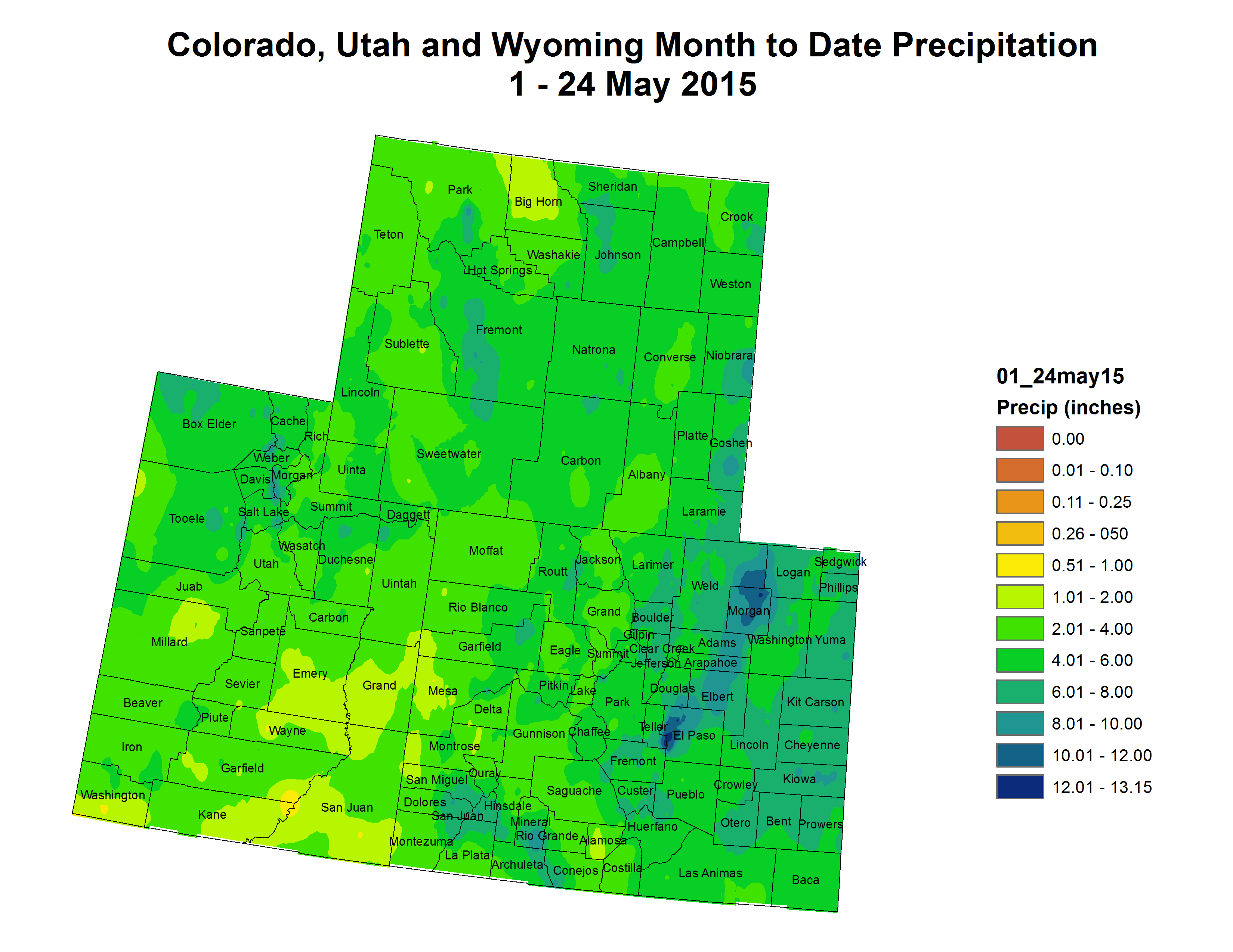
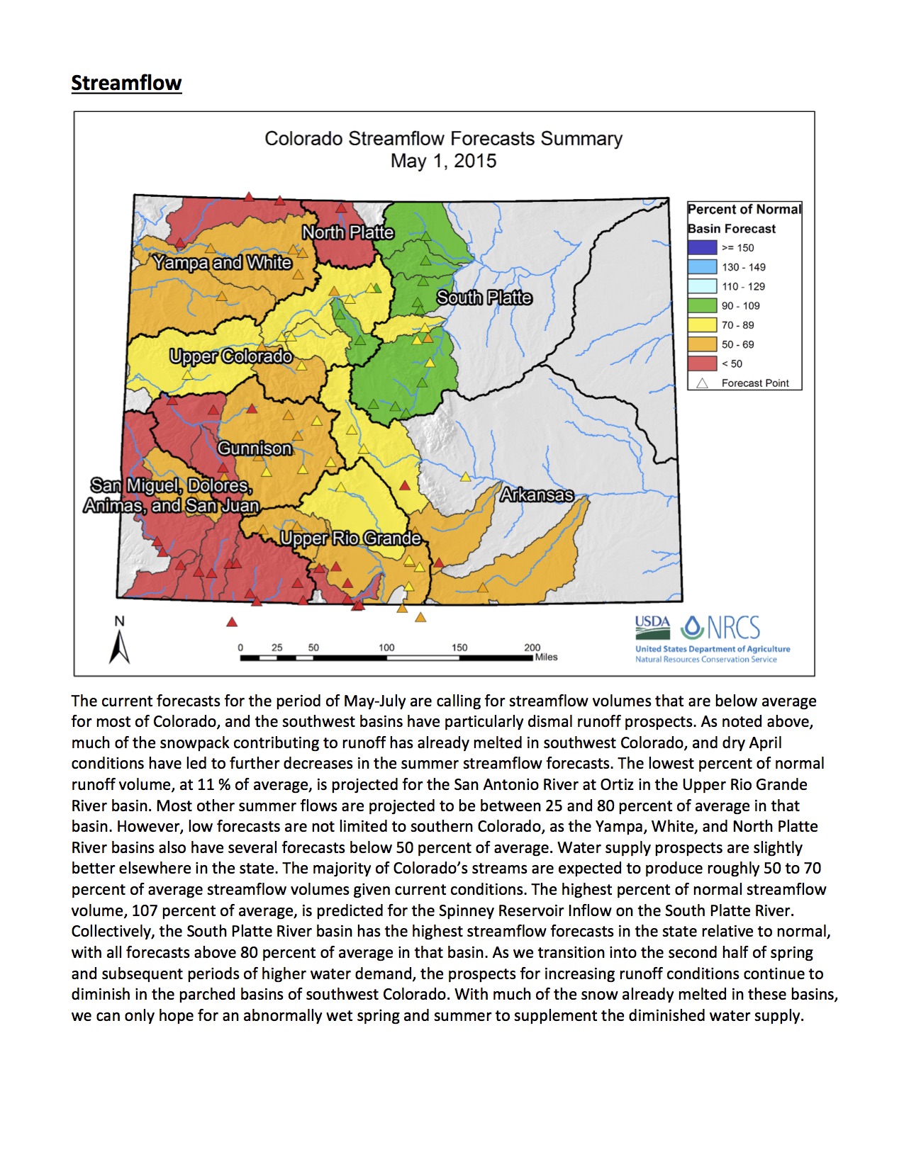
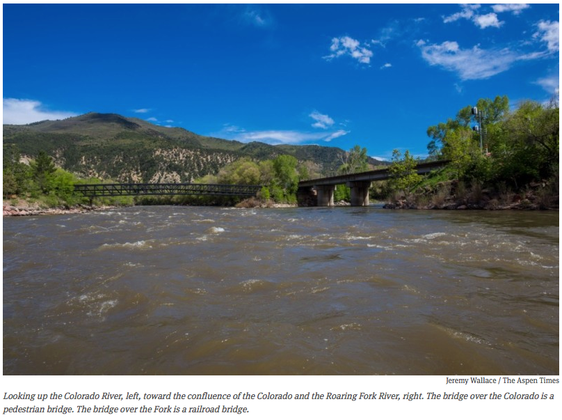
This Clean Water Rule is meant to clarify federal power, particularly in Western states such as Colorado, where 68 percent of streams are seasonal ones for which protection has been uncertain.

The rule, announced by Environmental Protection Agency administrator Gina McCarthy, won’t require new permits, she said, but it gives federal officials jurisdiction to crack down on polluters.

“This rule will make it easier to identify protected waters,” McCarthy said in a conference call with reporters. “This rule will not get in the way of agriculture.”

But some Colorado farmers and a national coalition of industry groups oppose it. They’ve asked Congress to intervene and are considering legal challenges.

EPA and U.S. Army Corps of Engineers regulators “are saying that if somebody decides that what you are doing on your land has an impact on what they call ‘waters of the United States,’ then the EPA has jurisdiction. If a private citizen complains about it, the EPA has a duty and responsibility to investigate and pursue the case,” Colorado Farm Bureau president Don Shawcroft said. “It means the EPA potentially is looking over our shoulder about everything we do — even for small seasonal streams and during heavy rain.”

EPA officials said 68 percent of streams in Colorado are seasonal or rain-dependent and that these now will be protected as long as they show signs of flowing and affect downstream waters.

The rule is designed to end uncertainty created by Supreme Court decisions in 2001 and 2006 that left small streams, headwaters and wetlands in limbo.

Those decisions suggested that waterways not entirely within one state, creeks that only contain water at certain times of year, and lakes not linked to larger water systems might not qualify as “navigable waters” and might not be covered under the 1972 Clean Water Act. The concern is that pollution of flowing waterways can make its way into sources of drinking water.

Democratic Sen. Michael Bennet on Wednesday didn’t take a position. Bennet “looks forward to reviewing this new rule and hopes it will be workable for Colorado,” a Bennet spokesman said. “He’s heard from farmers and ranchers, sportsmen, water providers and local governments who are all asking for the certainty a balanced rule can provide.”

While farm bureaus decried EPA overreach, Rocky Mountain Farmers Union president Kent Peppler called the rule a common-sense approach to protecting upstream water and downstream producers of food.

From Western Slope Now (Travis Khachatoorian):

Dozens of Colorado organizations and leaders are polarized in their opinions just moments after the U.S. Environmental Protection Agency announced a new rule that would protect hundreds of West Slope streams from pollution…

Environmentalists such as Conservation Colorado and Environment Colorado have hailed the decision as a victory.

“President Obama’s Clean Water Rule re-establishes important protections that fight pollution and keep Colorado’s drinking water, rivers, wetlands and tributaries clean,” said the executive director of Conservation Colorado in a press release.

But the issue is quickly dividing the political landscape. On the other side of the river, Colorado Senator Cory Gardner and West Slope Representative Scott Tipton have denounced the plan as a federal encroachment on water rights.

“This rule represents a massive expansion of federal power and puts the EPA in a ludicrous position of acting as the main regulator of ponds, ditches, and even intermittent streams across the country, said Sen. Gardner in a press release.

There are approximately 77 significant streams in Mesa County and Montrose County.

There’s still a 60 day waiting period before the Clean Water Rule would go into effect. The Republican controlled U.S. House has already passed a bill that would strip the new authority from the EPA.

From Conservation Colorado (Chris Arend):

Conservation Colorado Executive Director Pete Maysmith released the following statement on the Obama Administration issuing the “Clean Water Rule”, which re-establishes critical clean water protections for America’s rivers and streams:

“Today is an important day for Colorado’s most precious resource— our water. President Obama’s Clean Water Rule re-establishes important protections that fight pollution and keep Colorado’s drinking water, rivers, wetlands and tributaries clean. Coloradans cherish their clean water and understand that it is critical to our economy. Protecting the health of our children and grandchildren who drink, swim, and play in our waterways is vital to Colorado’s future. Recent polling shows that over 85% of voters support these new clean water rules which will protect the water of 1 in 3 Americans. We congratulate President Obama for restoring these important protections and standing up for healthy, clean water.”

Here’s the release from the EPA and USACE (Gina McCarthy/Jo-Ellen Darcy):

Today, EPA and the Army finalized a rule under the Clean Water Act to protect the streams and wetlands we depend on for our health, our economy, and our way of life.

The Clean Water Act has protected our health for more than 40 years—and helped our nation clean up hundreds of thousands of miles of waterways that were choked by industrial pollution, untreated sewage, and garbage for decades.

But Supreme Court cases in 2001 and 2006 put protection of 60 percent of our nation’s streams and millions of acres of wetlands into question. At the same time, we understand much more today about how waters connect to each other than we did in decades past. Scientists, water quality experts, and local water managers are better able than ever before to pinpoint the waters that impact our health and the environment the most.

Members of Congress, farmers, ranchers, small business owners, hunters, anglers, and the public have called on EPA and the Army to make a rule to clarify where the Clean Water Act applies, and bring it in line with the law and the latest science. Today, we’re answering that call.

Every lake and every river depends on the streams and wetlands that feed it—and we can’t have healthy communities downstream without healthy headwaters upstream. The Clean Water Rule will protect streams and wetlands and provide greater clarity and certainty to farmers, all without creating any new permitting requirements for agriculture and while maintaining all existing exemptions and exclusions.

The agencies did extensive outreach on the Clean Water Rule, hosting more than 400 meetings across the country and receiving more than a million public comments. EPA officials visited farms in Arizona, Colorado, Maryland, Mississippi, Missouri, New York, Pennsylvania, Texas, and Vermont.

Our nation’s original conservationists—our farmers, ranchers, and foresters—were among the most crucial voices who weighed in during this process. Farmers have a critical job to do; our nation depends on them for food, fiber, and fuel, and they depend on clean water for their livelihoods.

Normal farming and ranching—including planting, harvesting, and moving livestock—have long been exempt from Clean Water Act regulation, and the Clean Water Rule doesn’t change that. It respects producers’ crucial role in our economy and respects the law. We’d like give a few more specifics on our final rule, starting with what it doesn’t do.

  • The rule doesn’t add any new permitting requirements for agriculture.
  • It doesn’t protect new kinds of waters that the Clean Water Act didn’t historically cover. It doesn’t regulate most ditches and excludes groundwater, shallow subsurface flows, and tile drains. And it doesn’t change policy on irrigation or water transfers.
  • It doesn’t touch land use or private property rights. The Clean Water Rule only deals with the pollution and destruction of waterways.
  • Again, our rule doesn’t touch long-standing Clean Water Act exemptions and exclusions for agriculture. It specifically recognizes the crucial role farmers play and actually adds exclusions for features like artificial lakes and ponds, water-filled depressions from construction, and grass swales.
  • What the rule does is simple: it protects clean water, and it provides clarity on which waters are covered by the Clean Water Act so they can be protected from pollution and destruction.

    Feedback from the agricultural community led us to define tributaries more clearly. The rule is precise about the streams being protected so that it can’t be interpreted to pick up erosion in a farmer’s field. The rule says a tributary has to show physical features of flowing water to warrant protection.

    We also got feedback that our proposed definition of ditches was confusing. We’re only interested in the ones that act like tributaries and could carry pollution downstream—so we changed the definition in the final rule to focus on tributaries. So ditches that are not constructed in streams and that flow only when it rains are not covered.

    We’ve also provided certainty in how far safeguards extend to nearby waters—the rule sets physical, measurable limits for the first time. For example, an adjacent water is protected if it’s within the 100-year floodplain and within 1,500 feet of a covered waterway. By setting bright lines, agricultural producers and others will know exactly where the Clean Water Act applies, and where it doesn’t.

    Farmers and ranchers work hard every day to feed America and the world. In this final rule, we’ve provided additional certainty that they’ll retain all of their Clean Water Act exemptions and exclusions—so they can continue to do their jobs, and continue to be conservation leaders.

    We appreciate everyone’s input as we’ve worked together to finalize a Clean Water Rule that keeps pollution out of our water, while providing the additional clarity our economy needs. Learn more with this fact sheet.

    More Environmental Protection Agency coverage here.

    Colorado Water Plan update #COWaterPlan #ColoradoRiver

    Steamboat Springs
    Steamboat Springs

    From the Craig Daily Press (Tom Ross):

    “Overall, 10 million acre-feet of water rises in the mountains of Colorado, annually,” speaker Jay Gallagher told his audience. “The state’s population will grow to 8.5 or perhaps 9 million people over the next 50 years, but we’re facing a flat-lining water supply. And 40 million people are sustained by Colorado River water. It’s a big deal. It’s our lifeblood It’s a hard-working river.”

    Gallagher is general manager of the Mount Werner Water and Sanitation District in Steamboat Springs, but also sits on the Colorado Water Conservation Board, which is charged with assembling an overall state water plan from reports submitted by river basins all over the state. He was joined by Jackie Brown, district manager of the Routt County Conservation District.

    Brown serves on the Yampa/White/Green river basin roundtable, which will contribute its own goals for water management to the CWCB for consideration in the statewide plan.

    The rain that fell Tuesday night in the midst of what has turned out to be the wettest month of May on record in Steamboat Springs (6.33 inches of rain compared to the normal 2.24 inches for the month) amounts to an asterisk in a 35-year water plan, and there is a sense of urgency in the process, according to the speakers…

    The big water buffalo in the room, however, was the possibility that powerful Front Range water interests will succeed in influencing the water plan to include a new trans-mountain diversion (TMD) of water from Colorado’s Western Slope to the rapidly growing Eastern Slope.

    It was State Rep. Diane Mitsch Bush who put the possible implications of a new TMD for Western Colorado on the table. She serves on the Agriculture, Livestock & Natural Resources Committee that will review the new water plan at the legislature.

    “The South Platte and Metro Roundtable has a TMD right up front (in its water plan). Their first solution (to closing the water supply gap) is a TMD. How do you see that playing out in an agreement?” she asked Gallagher.

    He responded that the new water plan won’t represent policy, but instead, will set guiding principles for establishing new policies in the future.

    A new TMD, “would still have to go through questions about ‘who does it benefit?’” Gallagher said. “And one of the tenets of water policy is ‘Do no harm.’”

    Mary Brown, another member of the Yampa/White/Green Roundtable, added that intense negotiation is taking place among representatives of each basin in the state over seven criteria — playfully called the “Seven Points of Light” — that would frame decision making about any new TMD. One of the points being debated would require the developers of a new multi-billion TMD to assume ultimate hydrological risk. That implies the TMD would be junior to all other water rights on the river system. And that, in return, would raise significant questions about whether the diversion could be depended upon to support growth on the Front Range.

    Brown and Gallagher agreed after the meeting that most Front Range water districts would prefer any other means of expanding water supply to a TMD. However, failure to put a TMD on the table would be politically unpalatable among their constituents.

    More Colorado Water Plan coverage here.

    The EPA and USACE release the final #CleanWaterRules — some congressional heads explode

    From the Associated Press (Mary Clare Jalonik) via ABC News:

    The White House said the rules would provide much-needed clarity for landowners, but some Republicans and farm groups said they go much too far. House Speaker John Boehner declared they would send “landowners, small businesses, farmers, and manufacturers on the road to a regulatory and economic hell.”

    The rules, issued by the Environmental Protection Agency and the U.S. Army Corps of Engineers, are designed to clarify which smaller waterways fall under federal protection after two Supreme Court rulings had left the reach of the Clean Water Act uncertain. EPA Administrator Gina McCarthy said the waters affected would be those with a “direct and significant” connection to larger bodies of water downstream that are already protected.

    The Supreme Court decisions in 2001 and 2006 left 60 percent of nation’s streams and millions of acres of wetlands without clear federal protection, according to EPA. The new rules say a tributary must show evidence of flowing water to be protected — like a bank or a high water mark. The regulations would kick in and force a permitting process only if a business or landowner took steps to pollute or destroy those waters.

    President Barack Obama said in a statement that the rules will provide needed clarity for business and industry and “will ensure polluters who knowingly threaten our waters can be held accountable.”

    The rules face deep opposition from the Republican-led Congress and farmers concerned that every stream, ditch and puddle on their private land could now be subject to federal oversight. The House voted to block the regulations earlier this month, and a similar effort is underway in the Senate.

    Republican James Inhofe of Oklahoma, chairman of the Senate Environment and Public Works Committee, said his panel will consider the Senate bill to force the EPA to withdraw and rewrite the rules this summer.

    House Speaker Boehner called the rules “a raw and tyrannical power grab.”

    Farm groups have said the rules could greatly expand the reach of the clean water law and create confusion among officials in the field as to which bodies of water must be protected…

    These efforts were “to make clear our goal is to stay out of agriculture’s way,” McCarthy said in a blog on the EPA website.

    “Major economic sectors, from manufacturing and energy production to agriculture, food service, tourism and recreation, depend on clean water to function and flourish,” McCarthy said.

    The American Farm Bureau Federation has led opposition to the rules, saying they could make business more difficult for farmers. The group said Wednesday that it would wait to review the final rules before responding.

    The agriculture industry has been particularly concerned about the regulation of drainage ditches on farmland. The EPA and Army Corps said the only ditches that would be covered under the rule are those that look, act and function like a tributary and carry pollution downstream.

    Weekly Climate, Water and Drought Assessment of the Upper #ColoradoRiver Basin

    Upper Colorado River Basin month to date precipitation May 1 thru May 24, 2015
    Upper Colorado River Basin month to date precipitation May 1 thru May 24, 2015

    Click here to read the current assessment. Click here to go to the NIDIS website hosted by the Colorado Climate Center.

    #ColoradoRiver

    Snowpack/runoff news

    Click on a thumbnail to view a gallery of snowpack data from the Natural Resources Conservation Service.

    From the Fort Collins Coloradoan (Katie de la Rosa):

    May’s moisture did wonders for Larimer County’s snowpack, with the South Platte River Basin measuring 209 percent of normal for this time of year.

    On April 1, the snowpack was 89 percent of average, said Treste Huse, a meteorologist with the National Weather Service in Boulder.

    Despite the recent surge, it isn’t even the highest percentage the basin has seen in the last five years. This time last year, snowpack was at 230 percent of average. In 2013, it was at 364 percent, Huse said. In 2012, it was only 6 percent…

    As for the Poudre River, it was flowing at 2,350 cubic feet per second and up to 7.15 feet on the gauge in Fort Collins on Monday. The average for this time of year is just above 1,500 cfs, and flood stage is 10.5 feet.

    Wyoming Governor Matt Mead reacts to EPA “Waters of the US” rule

    Fen photo via the USFS
    Fen photo via the USFS

    Here’s the release via Governor Matt Mead’s office:

    Environmental Protection Agency (EPA) Administrator Gina McCarthy called Governor Mead to announce that she is signing the controversial Waters of the United States rule. Wyoming, along with a number of other states, asked McCarthy to work on concerns with the rule. Consultation with governors is required under the Clean Water Act.

    “I am disappointed at the lack of consideration for the law and procedure,” said Mead. “The Administrator ignored requests to consult with states and develop a rule that complies with the law and protects water.”

    Once it is signed the rule will go into the federal register for review and comment.

    “This rule has wide ranging impact,” said Mead. “I am frustrated the EPA has again stepped out of the bounds of its authority and has disregarded the role and concerns of the state.”

    West Salt Creek slide lake leaks, officials report — The Grand Junction Daily Sentinel

    Grand Mesa mudslide before and after via The Denver Post
    Grand Mesa mudslide before and after via The Denver Post

    From The Grand Junction Daily Sentinel (Gary Harmon):

    A new watercourse springing from the West Salt Creek landslide has Mesa County officials saying they’re paying close attention to the change.

    Tim Hayashi and Frank Kochevar Jr., respectively the senior engineer and survey supervisor for Mesa County, found the new stream as they visited the slide on Sunday, Hayashi said.

    The discovery gave new urgency to the landslide study, Hayashi said.

    “We’re at a point where Frank and I have gone from checking (on the slide) from once or twice a day to just about every hour,” Hayashi said. “And that’s ‘round the clock.”

    The new stream rises about 75 feet above the base of the slump block — the large mass of mud, rock and debris still clinging to the side of Grand Mesa, Hayashi said.

    Its appearance marks a “significant change” in the landslide and prompted heightened scrutiny of the slide according to an emergency action plan drawn up by the county for dealing with the slide. The plan accounts for three levels of response, of which the additional awareness is the first level.

    There is no immediate threat to residents or to the town of Collbran, six miles to the northwest, Hayashi said.

    Experts expected the stream to appear at some point, “it was just a matter of when,” Hayashi said.

    The source of the stream is the lake, or sag pond, that has collected in the V-shaped area between the mesa and the slump block, Hayashi said.

    “There is no other reasonable source of water” at this time, he said.

    Access to the slide area remains restricted at the top by the U.S. Forest Service. No one is permitted within 300 yards of the edge of the slide because of its instability.

    The rest of the slide sits on private property.

    Cameras, monitors and other devices are in place to alert officials of any movement, including a monitor about 100 feet above the new stream.

    Residents of the area are to be notified should conditions become hazardous, according to the county’s emergency plan.

    Officials with the U.S. Geological Survey, Colorado Geological Survey, and Department of Parks and Wildlife are monitoring the slide, as are the county and Forest Service.

    From The Denver Post (Anthony Cotton):

    A Level One, under the Emergency Action Plan, means something has changed that requires a heightened level of awareness, the county said on its Facebook page. It does not mean citizens near the area face an extra safety risk.

    The highest alert level is Level Three.

    The appearance of a stream of water on the West Salt Creek landslide area above Collbran prompted the decision.

    “We expected to see water-related changes in the landslide during spring runoff,” said Tim Hayashi, Senior Engineer for Mesa County. “But one of the looming questions has been, ‘What would the pond do?'”[…]

    Mesa County’s emergency plan calls for immediate notification of the public when conditions become hazardous to citizens. Collbran residents have previously been briefed on the possibility of water spilling over the sag pond or finding a route down the debris area.

    Good News for the Nation’s Waterways — The New York Times

    Early winter along the Rio Grande on the Gilmore Ranch via the Rio Grande Initiative
    Early winter along the Rio Grande on the Gilmore Ranch via the Rio Grande Initiative

    From Taking Note: The New York Times (Robert B. Semple, Jr.):

    Joan Mulhern would have loved this day, had she lived to see it. Joan, who died at the age of 51 in December 2012, was a feisty Massachusetts native, passionate Red Sox fan and environmental lawyer who gravitated to the Washington office of Earthjustice, an advocacy group she served as a senior attorney while becoming an absolute terror to anyone who threatened the waters of the United States — legislators and lobbyists, passive regulators, coal companies that insisted on blasting the tops off mountains and dumping coal slag in the valleys and streams below. Her biggest cause, in which she enlisted every environmentalist, journalist and ordinary citizen she could buttonhole, was to restore the full meaning and scope of the 1972 Clean Water Act, whose protections, she believed, had been fatally weakened by the courts and by politicians in thrall to special interests — mainly developers, industrial and municipal polluters, and big farmers. Next week, barring an 11th-hour cave-in by the White House, the Environmental Protection Agency and the Army Corps of Engineers are expected to issue a firm, clear rule restoring federal protections to most (though probably not all) of the waters the Act’s framers, and Joan, had hoped to protect.

    The Clean Water Act, one of the more successful of the landmark environmental statutes enacted under Presidents Lyndon Johnson and Richard Nixon, was for 30 years broadly interpreted by the courts and regulators as shielding virtually all the waters of the United States from pollution and unregulated development — seasonal streams and remote wetlands, as well as lakes and large navigable waters. The basic idea was that small waters have some hydrological connection to larger watersheds and should be protected against pollution that would inevitably find its way downstream, threatening ecosystems and drinking water.

    Then came two confusing Supreme Court decisions — one in 2001 suggesting that the law applied only to navigable waterways, and another in 2006 suggesting that only waters with a “significant nexus” to larger waters (Justice Kennedy’s words) could be protected. These decisions — plus subsequent and largely unhelpful guidance from the George W. Bush administration — confused regulators and exposed millions of acres of wetlands and thousands of miles of streams to development. According to one E.P.A. study, as well as investigations by two Democratic Congressmen, Henry Waxman and the late James Oberstar, this confusion compromised federal enforcement in over 500 pollution cases and allowed polluters to dump dangerous chemicals into many seasonal lakes, streams and other waterways without fear of federal enforcement.

    More Environmental Protection Agency coverage here.

    California drought holds lessons for Colorado — the Colorado Independent #COWaterPlan

    The plains around DIA were parched by the scorching 2012 drought, although groundwater pumping along the South Platte River enabled some farms to continue irrigating -- photo by Bob Berwyn
    The plains around DIA were parched by the scorching 2012 drought, although groundwater pumping along the South Platte River enabled some farms to continue irrigating — photo by Bob Berwyn

    From the Colorado Independent (Bob Berwyn):

    Coloradans are watching California dreams turn to dust during an unrelenting four-year drought. There, the only way some people can get water is off the backs of delivery trucks. Homeowners are digging up backyard swimming pools, tearing up lawns and shaming water-wasting neighbors with calls to TV stations: The family next door has a leaky garden hose. The nightly news actually covers these types of stories.

    The Golden State has seen plenty of dry spells over the past few centuries, but this drought is different. It has has spread farther and lasted longer than any other drought on record. And it has spurred the most draconian water-rationing measures in the state’s history.

    Governor Jerry Brown ordered a 25 percent cut in urban water use, and proposed fines of up to $10,000 per violation for the biggest water wasters. And this week, California’s water czars said they may order farmers with 100-year-old water rights to give up some of their water. It’s a nearly unthinkable move that would shake the foundation of the state’s water laws and almost certainly trigger fierce courtroom water wars.

    The California drought has intensified strife between cities and farms, the northern and southern parts of the state, and social and economic classes — all of which are being watched carefully by nervous leaders in Colorado.

    Even with “normal” snow and rain, the state is facing a water crisis, according to Colorado Gov. John Hickenlooper. By 2050, the state will be billions of gallons short of what it needs to sustain its cities, factories, farms and rivers, Hickenlooper said in 2013 when he ordered state agencies to swiftly tackle one of Colorado’s most urgent issues. The final plan, due by the end of this year, is aimed at averting those shortages, and the California drought experience is helping to shape that plan.

    A new lawn

    This isn’t anything like I saw in Colorado,” says Jenn Ohlsson, who recently moved from Summit County to Riverside, east of Los Angeles, in the scruffy foothills of the San Bernardino Mountains, where things are dry even in the best of years.

    TV, radio and the newspapers are all sending out a steady barrage of drought info, which is a little annoying at times but ensures that people are thinking about saving water every day, Ohlsson says.

    “They even have helicopters flying around to see who’s wasting water,” she says, adding that she’s cut back a bit on water use. She doesn’t know exactly if she’s met the state’s 25 percent target, but she makes sure her dishwasher and washing machine are full before she runs them. She and her husband haven’t given up their backyard pool yet, but they did get a cover to cut evaporation, and they skip showers once in a while, she says.

    But some suburban dreams never die, no matter how hot and dry it gets. Ohlsson says her husband’s grandmother planted a new lawn in the backyard of her Riverside house this past spring, just as California’s rainy season ended with a whimper and the lowest snowpack ever recorded in the Sierra Nevada Mountains.

    After nearly running out of water during the 2002 drought, the town of Dillon, Colorado worked with state and federal agencies to enlarge an old reservoir to help ensure reliable water supplies during future dry spells. Photo courtesy of Don Sather.
    After nearly running out of water during the 2002 drought, the town of Dillon, Colorado worked with state and federal agencies to enlarge an old reservoir to help ensure reliable water supplies during future dry spells. Photo courtesy of Don Sather.

    Colorado drought?

    So is there really a chance that Colorado could see a drought of similar proportions?

    It depends who you ask.

    “We all know that multiyear drought has happened before and will happen again,” says state climatologist Nolan Doesken. Even in the best of times, some part of Colorado is either going into drought, in drought, in bad drought, or recovering from drought, but the state always has a couple of weather wildcards, Doesken explains. Just like California, Colorado relies heavily on winter rains to refill rivers, lakes and reservoirs. But, here, rainfall in other seasons can help ease water woes.

    “Where we are perched, drought will always look different. We can dodge the bullet more easily than California because we have three wet seasons,” Doesken says. “So our droughts are less likely to persist and are more likely to be interrupted and softened,”

    Colorado has, in fact, experienced multiple 3- or 4-year droughts over the last century, including one during the [1930s] Dust Bowl era. The most recent extended drought, from 1953 to 1956, is a modern water-planning benchmark for Colorado against which cities design last-ditch defenses against running out of water, says Jeff Lukas, a Colorado-based scientist with the Western Water Assessment, a university-based research program tracking climate trends in the West.

    Colorado’s longer droughts just haven’t been as intense as in California, but that doesn’t mean they won’t be in the future, Lukas says.

    “The hitch is that the planning has assumed that a 1950s-type drought is literally the worst-case scenario,” Lukas says. Now, scientists realize that human-caused global warming and natural climate variation could plausibly lead to even-worse-case scenarios.

    How does your garden grow?

    Lisa Paul, a 30-year California resident, has been through several drought cycles and says she can’t imagine it getting any worse. During a drought back in the 1990s, when she lived in San Francisco, she used a bucket while showering to capture some water for the garden around her downtown Victorian.

    This time around, there was little political leadership in the early stages of the drought, when decisive action could have helped ease some of the pain Californians are feeling now, she says.

    Two years ago, Paul moved to San Jose, at the south end of San Francisco Bay, and promptly tore out the lawn from around her house in the historic Rose Garden neighborhood and replaced the grass with native plants.

    “I scandalized my neighbors,” she said. “They told me I was the most disruptive person ever to move into the neighborhood, just for tearing out the lawn. I had people practically screaming at me, saying, ‘You’re not going to take my lawn away. It’ll make my property value go down.’”

    Paul and her husband also own property north of San Francisco, in Sonoma County, where they planted a two-acre “retirement” vineyard just a year before the current drought started. The timing couldn’t have been worse, but they kept at it, partly by capturing rainwater in a 2,000 gallon cistern.

    The attitudes in that rural area are different than those she encountered in urban San Jose, she says.

    “In Sonoma, all the farmers have been talking about the drought and climate change for years. You will not find a farmer who doesn’t believe in global warming,” Paul says. The farmers know water is everything, and they know where it comes from.

    City dwellers, not so much.

    “The farther water is from your livelihood, the more disconnected you are,” she says.

    She also finds a political disconnect on some of the charity boards she serves on, where she says some Republicans discount the current California drought.

    “The same people that deny climate change are denying the drought,” she says. “They’re attacking environmentalists for fighting to keep water in the rivers for fish, saying that has caused artificial drought,” she says.

    During the 2002 drought, Dillon Reservoir, one of Denver’s main sources of drinking water, dropped to a record-low level, forcing mandatory watering restrictions in the city and hampering recreation in Summit County.  Photo by Bob Berwyn
    During the 2002 drought, Dillon Reservoir, one of Denver’s main sources of drinking water, dropped to a record-low level, forcing mandatory watering restrictions in the city and hampering recreation in Summit County.
    Photo by Bob Berwyn

    Denver Water

    Whatever the politics or the climate, Denver Water CEO and general manager Jim Lochhead says he has to be prepared to ensure steady water supplies for 1.3 million customers. He and other water bosses are watching California carefully to see what works — and what doesn’t.

    “We can’t be complacent. Once a drought cycle starts, we can’t predict when it will end. Drought responses need to begin at the first signs of drought,” Lochhead says. “We can’t rely on the past to predict the future. The California drought, like the continuing drought in the Colorado River Basin, is unlike any we’ve seen before. We can never assume a drought will be normal.”

    The emerging Colorado water plan could help prepare the state by fostering partnerships between cities, farms and environmental groups, Lochhead says.

    “The response to the California drought has been delayed because of disagreements between sectors. We need to understand beforehand how we’re going to respond to severe drought,” he says. “Colorado should have a plan for how cities and agricultural producers can share water supplies during severe drought conditions.”

    And Colorado can’t address regional drought issues on its own. So much of the state’s water supplies are affected by what happens in other states downstream, especially by dwindling water supplies in Lake Powell and Lake Mead. If those reservoirs drop below a certain level, Colorado could be forced to send water that is needed by the Front Range.

    If the long-term regional drought continues, all the Colorado River’s states need to be much more aggressive in developing an emergency response plan, Lochhead says.

    “This will mean moving water from reservoirs higher in the basin down to Lake Powell,” he says, adding that some type of interstate program to cut demand will be critical to maintain Colorado River flows required by the law of the river.

    Other strategies

    Finding more ways to move water around the state during a drought could also help, says California state climatologist Michael Anderson, a Colorado native who knows both states well.

    California’s massive network of canals and reservoirs enables the state to move water to where it’s needed most. Other western states don’t have that same ability, which means they get hit by droughts harder and faster, Anderson says.

    Previous droughts have also spurred California to make water law changes that let farmers sell their water to cities quickly and on a large scale. Anderson says California does that much more than any other state. Adding that ability in Colorado would be a big step toward better drought preparedness.

    But statewide conservation should be first and foremost in any drought and water-planning conversation, says Bart Miller, a conservation attorney with Western Resource Advocates.

    The evolving water plan is a chance for Colorado to set a course that minimizes the threat of drastic water rationing and other severe restrictions, Miller says. To do that, the state water plan has to focus on “making the most of the water we’ve already developed.” That means more conservation, more water recycling, and faster, better ways to share water between irrigators, cities, and rivers when supplies get tight.

    “The entire Colorado River basin needs to deal with less water going forward and plan accordingly,” he says. “And, we can design new communities to have a smaller water footprint, so that we don’t feel the need to pull more water from the Colorado River Basin on the West Slope. While no one can be truly drought-proof, making smarter choices with the water we already have puts us in a better position to deal with any future drought,” Miller concludes.

    The big dry

    Even with all the preparations and measures mentioned by Anderson, Californians have been hit hard by the extended dry spell. It all brings back old memories, says Bob Gahl, a 30-year California resident who says he adjusted his lifestyle to match the state’s semi-arid setting many years ago.

    “During the last drought, I was filling the tub with a few inches of water for one child, then adding some more for the next, then adding some more for the third,” Gahl says. After bath-time, he would run a hose into the house to siphon the water to his outside gardens.

    Gahl says he practices all these conservation measures against a statewide political backdrop that lends itself to cynicism. Urban users take big hit, while California farmers — who use 80 percent of California’s water — continue to get massive subsidies, he says, describing what he sees as inequities in the way the state allocates water.

    “California subsidizes farmers growing rice in the desert up around Sacramento,” Gahl says. “And, apparently, in this latest drought, the state has some sweetheart deal with those using fracking to get oil out of the ground, but screws the farmers. One need only drive down Highway 5 to see how they feel about it,” Gahl adds, mirroring concerns that have surfaced in Colorado about water use by the oil and gas industry.
    Many of his concerns are exactly the kinds of things Colorado is trying to address upfront in its new water plan, before there’s an epic crisis. Gahl says it’s not really that complicated. California needs to stop subsidizing water use in areas where it doesn’t make sense, and make sure that political cronyism isn’t driving water policy, he says.

    “I think that probably cuts across all states,” he says. “This is my third drought rodeo in California, and the same idiocy continues to rear its head each and every drought.”

    Snowpack/runoff news

    May 1, 2015 Colorado streamflow forecast map via the NRCS
    May 1, 2015 Colorado streamflow forecast map via the NRCS

    From The Aspen Times (Scott Condon):

    The high elevation snowpack in the Roaring Fork watershed has surged off the charts this month after cold temperatures halted melting and storms kept adding layers of heavy, wet snow.

    The snowpack is 373 percent of average at the Natural Resources Conservation Service’s automated snow measuring station at Ivanhoe Reservoir in the upper Fryingpan River Valley. The snowpack contains the equivalent of 13.8 inches of water at the site, which is at an elevation of 10,400 feet.

    The conservation service’s snow measuring station near the headwaters of the Roaring Fork River east of Aspen showed a snowpack 236 percent of average with snow water equivalent of 8.5 inches on Friday.

    The snowpack was below average for most of the Roaring Fork River basin for much of the winter.

    The gloomy forecast for a dry summer and low stream flows suddenly doesn’t look so bleak.

    “Typically this time of year, snow at high elevations is melting as temperatures are increasing,” the Basalt-based Roaring Fork Conservancy said in its weekly snowpack and stream flow report this week. “Due to the recent wet, cold weather we are receiving snowfall at the higher elevations, rain in the valley, and slower melting of snow. Therefore, streams are flowing between 40 and 68 percent of average for this time of year.”

    The onslaught of precipitation has altered outlooks for peak runoff. The U.S. Bureau of Reclamation initially figured the peak this year would be during the end of May, according to Mark Fuller, director of the Ruedi Water and Power Authority, which works closely with the agency on a number of issues.

    “They’ve pushed that back a couple of weeks,” Fuller said.

    Ruedi Reservoir, 13 miles east of Basalt, is currently 80 percent full at 81,520 acre-feet of water in storage.

    The reclamation bureau’s office that oversees Ruedi Reservoir didn’t respond to messages from the Aspen Times requesting comment on water management issues this year.

    “The Bureau of Reclamation tries to manage it so it will fill by the first of July,” Fuller said.

    WISE Project set to turn dirt in June

    WISE System Map September 11, 2014
    WISE System Map September 11, 2014

    From the Parker Chronicle (Mike DiFerdinando):

    Western Summit Constructors Inc. has been contracted to oversee design and construction of major infrastructure for the Water Infrastructure and Supply Efficiency project. Construction will begin in June and continue into 2016, when water deliveries will begin.

    “This is a significant milestone in our long-term plan to transition to a renewable water supply,” said Eric Hecox, executive director of the South Metro Water Supply Authority. “With construction agreements now in place, we will break ground in coming weeks to begin connecting water systems throughout the Denver metro area.”[…]

    The group tasked with utilizing this water is the South Metro WISE Authority. The primary purpose of the authority is to reduce members’ dependence on nonrenewable Denver Basin wells and provide a reliable, long-term water supply for residents.

    The WISE members are funding the new infrastructure that will move the water from Aurora’s Binney Water Purification Facility to its end locations, beginning in 2016. Water purchased by Douglas County entities, as well as by some of the other providers, will be stored at the Rueter-Hess Reservoir south of Parker.

    prairiewaterstreatment
    Prairie Waters Project schematic via Aurora Water


    Aurora’s Prairie Waters system will provide the backbone for delivering water from the South Platte when Aurora and Denver Water have available water supplies and capacity.

    The water will be distributed to the south metro communities through an existing pipeline shared with Denver and East Cherry Creek Valley Water and Sanitation District, plus new infrastructure that will be constructed over the next 16 months.

    More WISE Project coverage here.

    Snowpack news

    May 1, 2015 Colorado streamflow forecast map via the NRCS
    May 1, 2015 Colorado streamflow forecast map via the NRCS

    From the Leadville Herald Democrat:

    Typically, by May 1 nearly all mountain snowpack measuring locations in Colorado are dominated by snowmelt opposed to snow accumulation, with the turning point or peak accumulation occurring slightly after April 1.

    However, this year all basins experienced the turning point in early March with the exception of the South Platte, which due to mid-April storms, was able to achieve a snowpack peak this year close to normal.

    When viewed from the Front Range, it may seem that recent precipitation has substantially increased the statewide year-to-date total (currently at 80 percent of normal), but the fact is that statewide April 2015 precipitation was only 71 percent of normal, while the South Platte April precipitation was 110 percent of normal. Mountain snowpack follows the same storyline; the South Platte snowpack is at 96 percent of normal on May 1, while statewide snowpack is just 61 percent of normal. The Rio Grande snowpack is the lowest in the state at 25 percent of normal on May 1.

    “Statewide snowpack peaked during mid to early March at about 75 percent of the normal peak snowpack. This means that mountain snowpack this year will only provide about three quarters of the typical snowmelt to contribute to streamflow” said Brian Domonkos, hydrologist with the USDA Natural Resources Conservation Services Colorado Snow Survey Program. During the snowmelt season, when attempting to get a better understanding of water supply for the remainder of the water year, it is important to remember that snowpack is not the only factor involved in spring and summer runoff. Other factors to consider include snowpack peak timing and spring rain.

    Snowpack peak timing, which occurred early this year, often results in poor runoff efficiency. Monthly precipitation has been well below normal in nearly every basin for the last two months, which carries more weight since March (63 percent of normal) and April are the two months of the year in which Colorado typically receives the most precipitation. Additionally, April often provides rain at the lower elevations, which does not add to the snowpack, but often augments streamflow. Largely that rain has not come to Colorado.

    These factors and many others, Domonkos goes on to say, “paint a poor streamflow forecast picture for much of the state heading into spring and summer of 2015.” Future near or above normal precipitation would improve streamflow prospects in most watersheds that are currently below average. However, without abundant rain, streamflow outlooks will likely not improve enough to make a substantial difference in the entire water budget.

    The Upper Ark district assesses dry-up efforts at Yale Lake — The Mountain Mail

    Graphic via the Upper Arkansas Water Conservancy District
    Graphic via the Upper Arkansas Water Conservancy District

    From The Mountain Mail (Joe Stone):

    Upper Arkansas Water Conservancy District officials continue to assess efforts to dry up land formerly irrigated by the Thompson Ditch, including draining Harvard and Yale lakes west of Buena Vista.

    “Yale Lake is definitely affecting the groundwater level,” said district engineer Chris Manera in his progress report to the Upper Ark board of directors during their Thursday meeting in Salida.

    Manera presented data collected since January from nine district monitoring wells and nearby private wells that show dropping groundwater levels since Yale Lake was drained.

    Manera said Harvard Lake is down gradient from the monitoring wells, and he saw no affect on water levels when it was drained in March.

    Manera’s report confirms suspicions that seepage from Yale Lake hindered conservancy district efforts to dry up land once irrigated by the Thompson Ditch, a requirement for the district to use its Thompson Ditch water right for augmentation on Cottonwood Creek.

    As previously reported, the groundwater level needs to drop at least 6 feet below the surface for the conservancy district to receive credit for drying up the land.

    The land in question consists of an 11.51-acre parcel and a 2.84-acre parcel. Manera said the smaller parcel “is dried up” as are portions of the larger parcel.

    During the Enterprise Committee portion of the meeting, hydrologist Jord Gertson reported the district currently stores 2,663.2 acre-feet of water in its reservoirs.

    Gertson said all district reservoirs are full except for O’Haver Lake, which is being filled and should be full by the end of May.

    Gertson also presented snowpack and precipitation data showing above-average conditions for the Upper Arkansas Valley.

    After plummeting in March, Arkansas River Basin snowpack rebounded in April to reach peak depth in early May, putting the basin at 111 percent of average, Gertson said.

    Gertson also presented the National Oceanic and Atmospheric Administration’s long-range precipitation outlook, which projects “well-above average precipitation” this summer in Colorado.

    During the legislative update, district consultant Ken Baker mentioned House Bill 15-1259, which would have allowed Coloradans to collect up to two 55-gallon rain barrels of water that drains off their rooftops.

    The bill died in the Senate May 5, but Baker believes the bill will return in a future legislative session and indicated that the bill runs afoul of the state’s doctrine of prior appropriation, which lies at the heart of Colorado water law.

    Rain naturally seeps into the ground or drains into streams, and Baker pointed out that collecting rain in a barrel deprives downstream water rights holders of water to which they are legally entitled.

    In other business, Upper Ark directors:

  • Learned that the judge in the district’s Cottonwood Creek diligence case signed the decree, a necessary step toward making a conditional water right absolute. Diligence must be proved in a water court proceeding every 6 years.
  • Heard a U.S. Geological Survey presentation about water use trends in Colorado and the Arkansas Vallery.
  • Learned that stipulations are pending from several objectors in the district’s 04CW96 exchange case, which should preclude the need for the case to go to trial in June.
  • Learned that the district water management plan is under review and should soon be available for public comment on the district website, http://uawcd.com.
  • Learned that an intergovernmental agreement with the town of Buena Vista for storing water in Cottonwood Reservoir is nearing completion.
  • Approved a $1,000 Colorado Water Congress Stewardship Project sponsorship.
  • More Upper Arkansas Water Conservancy District coverage here

    Reclamation says it’s time to cut back on #ColoradoRiver use, others ask about storage #COWaterPlan

    Colorado River Basin including Mexico, USBR May 2015
    Colorado River Basin including Mexico, USBR May 2015

    From The Grand Junction Daily Sentinel (Gary Harmon):

    Colorado River water users will have to get used to more water conservation, according to a U.S. Bureau of Reclamation report that was faulted in Colorado for failing to consider storage as a drought measure.

    The report calls for several steps, including technology improvements and behavior change, to increase low-water landscapes, along with increased funding for environmental and recreational water-flow requirements and greater coordination of water and land planning.

    “This report is reassuring proof that the Colorado River Basin report is not just another report sitting on a shelf. That report, along with the ongoing drought, is a call to action,” said Chris Treese of the Colorado River Water Conservation District, which participated in it.

    If nothing is done, “In western Colorado and across the arid West, we could lose our farming and ranching heritage and its economic and environmental benefits if we don’t come together now to cooperatively address this extreme challenge,” Treese said.

    The call falls short of the needs on the West Slope, said Ute Water Conservancy District General Manager Larry Clever, who called the recommendations the “same stuff” that has been discussed in other forums.

    Missing is the recognition that storage is needed, Clever said.“If we want to work on drought, we are going to have to store water somewhere, and it would be nice to store it where it didn’t evaporate,” Clever said.

    Colorado’s water plan in the making includes storage, Gov. John Hickenlooper said Tuesday before the Associated Governments of Northwest Colorado, who pointed to the potential of holding more water at high elevation by expanding existing impoundments.

    Storage is “a big option” in the plan as it’s being drafted, said James Eklund, who heads the Colorado Water Conservation Board, which is drafting the water plan.

    More Colorado River Basin coverage here.

    Obama Plans New Rule to Limit Water Pollution — The New York Times

    Fen photo via the USFS
    Fen photo via the USFS

    Environmentalists have praised the new rule, calling it an important step that would lead to significantly cleaner natural bodies of water and healthier drinking water.

    But it has attracted fierce opposition from several business interests, including farmers, property developers, fertilizer and pesticide makers, oil and gas producers and a national association of golf course owners. Opponents contend that the rule would stifle economic growth and intrude on property owners’ rights.

    Republicans in Congress point to the rule as another example of what they call executive overreach by the Obama administration. Already, they are advancing legislation on Capitol Hill meant to block or delay the rule.

    Gina McCarthy, above, the E.P.A. administrator, who is expected to release the final version of a new rule intended to protect the nation’s drinking water this week.

    More Environmental Protection Agency coverage here.

    Watching the mouth of the Roaring Fork River — Aspen Journalism

    railroadbridgeoverroaringforkrivermay2015viaaspenjournalismjeremywallaceaspentimes

    From Aspen Journalism (Brent Gardner-Smith):

    As my raft floated under the railroad bridge at the confluence of the Roaring Fork and Colorado rivers last week, I was wondering just how much water would flow out of the Fork and into the Colorado this year.

    Certainly less than average, given that the snowpack peaked in March and began melting off, I mused, taking a stroke to catch the big eddy that forms just shy of the mighty Colorado, where the Fork comes in across from Two Rivers Park in Glenwood Springs after draining 1,543 square miles of land.

    Perhaps the wet and cold weather of late April and much of May will continue to forestall a sudden flash of melting snow, so what snow we still have in the high country will come off in a nice steady fashion.

    But spinning around the eddy, I knew how easy it was, as a boater, to be wrong about water and weather. It is also, as it turns out, a tricky time of year for professional hydrologists to predict run-off, as data from low-elevation snow-measuring sites tapers off and daily weather conditions can play a big role in shaping how much water flows, and when it does.

    In mid-March, which felt like summer already, a trip on the Green River starting April 12 seemed like a good bet this year to enjoy some warm weather. But a big storm swept in that week and blasted the river with freezing rain.

    The same storm laid down 11 inches of snow on Aspen Mountain by Friday, April 17, making for a memorable closing weekend for some.

    After warming up from that trip, I ventured optimistically out again during the first full week of May, this time on the Colorado River west of Loma. And I was soon engulfed in the downpours of May 5 and 6 that lead to river levels across the region jumping up.

    Between May 5 and May 7, for example, the flow in the lower Fork doubled from a 1,000 cubic feet per second to over 2,000 cfs.

    So when I went out on May 13 for my first trip of the season down the Roaring Fork from Carbondale to Glenwood, I wasn’t surprised that it started raining. It’s just been that kind of season so far — in fact, through May 19, total precipitation in the Roaring Fork River watershed was 204 percent, or double the normal amount of precipitation. according to the Natural Resource Conservation Service (NRCS).

    But the Fork was flowing that day at 1,110 cubic feet per second, which was enough water to have a perfectly nice float, especially as I did see some sun (and some red-wing blackbirds).

    But will the river get much bigger this year, I wondered as I rowed toward Glenwood.

    redcanyonfromroaringforkmay132015apenjournalimsjeremywallaceaspentimes

    Below average flows

    The Colorado River Basin Forecast Center in Salt Lake City forecast on May 19 that the Roaring Fork will most likely peak this year in mid- to late June at 4,300 cfs, as measured at Veltus Park, just above the Fork’s confluence with the Colorado.

    That’s 73 percent of the Fork’s average annual peak of 5,920 cfs, which typically occurs between May 29 and June 23.

    While this year’s likely peak flow of 4,300 cfs is certainly better than the lowest peak flow on record — 1,870 cfs on June 3, 2012 — it’s also way below the historic peak of 11,800 cfs on July 13 in 1995.

    The forecast peak flow has increased given the cool and wet weather in May. So, if April showers bring May flowers, May showers are likely to bring better boating on the Fork in June.

    “I would say it is very likely (the Roaring Fork) will see a below average peak flow this year,” said Brenda Alcorn, a senior hydrologist with the Forecast Center.

    However, she added that what snowpack we do have “is in better shape than it was in 2002 and 2012, so I do not expect a record low peak.”

    But just how much water comes, and when, is now weather dependent.

    “Spring temperatures and precipitation play a significant role in the pattern of snowmelt runoff and consequently the magnitude of peak flows,” Alcorn said. “An extended period of much above normal temperatures or heavy rainfall during the melt period can cause higher than expected peaks, while cool weather can cause lower than expected peaks.”

    On Friday, May 15, Julie Malingowsky, a meteorologist with the National Weather Service in Grand Junction, said the period to at least May 25 looked cooler and wetter than normal, and longer-range forecasts indicate that the next several months could be wetter than normal.

    (Also, see the Intermountain West Climate Dashboard of indicators at Western Water Assessment)

    But probably not wet enough make up for the skinny snowpack.

    “Even though it has been a wet month, we are still drier than normal,” Malingowsky said.

    confulenceroaringforkcrystalriver05132015aspenjournalismjeremywallaceaspentime

    Below average supply

    Another view of this year’s water picture is available from the Natural Resources Conservation Service’s “Colorado Water Supply Outlook Report,” which was published on May 1.

    The report shows that the “most likely” amount of water to reach the bottom of the Roaring Fork between April and the end of July is 450,000 acre-feet, according to Brian Domonkos, a data collection officer with NRCS.

    That’s below the 30-year average of 690,000 acre-feet flowing down the Fork for the period from April to August. (The Roaring Fork delivers, on average, 871,100 acre-feet of water to the Colorado River over a full year, according to the Colorado Division of Water Resources).

    The water-supply report said that current conditions point to “a below normal streamflow forecast picture for much of the state heading into spring and summer of 2015.”

    However, Gus Goodbody, a forecast hydrologist with NRCS, said the amount of water expected to flow out of the Roaring Fork is likely to increase from the May 1 forecast by five to 10 percent, given May’s weather so far.

    “It’s going to go up,” he said.

    Another indicator of potential run-off is the measure of the “snow water equivalent” at SNOTEL measuring sites in the Roaring Fork basin.

    The average from the eight SNOTEL sites in the Roaring Fork basin was 108 percent on May 19, but that’s without complete data from four of the sites.

    That number — 108 percent — has been climbing steadily since May 1, but it’s not an indicator that the snowpack has been growing. What it does show is that the cool and wet weather has slowed the run-off and moved the data closer to the historic average — which, again, bodes well for June boating. But in addition to the snowpack and the weather, there are other factors that dictate the flows in the Fork at Glenwood Springs.

    lookingupthecoloradoriverconfluenceroaringforkaspenjournalismjeremywallaceaspentimes

    Off the top

    An average of 40,600 acre-feet of water a year is collected from the upper Roaring Fork River basin and sent through a tunnel under Independence Pass and into Twin Lakes Reservoir, destined for Aurora, Colorado Springs, Pueblo and Pueblo West.

    The Twin Lakes diversion takes 40 percent of the water out of the upper Roaring Fork basin above Aspen, according to the 2012 Roaring Fork Watershed Plan.

    Another 61,500 acre-feet is collected on average each year from tributaries of the upper Fryingpan River and sent east through the Bousted and Busk tunnels. That accounts for 37 percent of the water in the upper Fryingpan headwaters.

    As such, there are many days when there are rivers heading both east and west out of the Roaring Fork River watershed, and the ones heading east can often be bigger.

    For example, on May 13, while I was floating on 1,110 cfs at the bottom of the Fork, there was 136 cfs of water running under the Continental Divide in the Twin Lakes — Independence Pass Tunnel, which can, and does, divert up to 625 cfs later in the runoff season.

    And the Bousted Tunnel, which transports the water collected from the headwaters of the Fryingpan River, as well as Hunter and Midway creeks in the Roaring Fork basin, was diverting 101 cfs on May 13.

    Meanwhile, the gauge on Stillwater Drive on May 14 showed the main stem of the Fork was flowing, just east of Aspen, at 111 cfs.

    Then there is the water diverted out of the rivers in the basin and into one of the many irrigation ditches along the Fork, the Crystal and other streams in the basin.

    Ken Ransford, a member of the Colorado River Basin Roundtable, estimates that the 12 biggest irrigation ditches on the Roaring Fork and Crystal rivers divert about 115,000 acre-feet of water a year.

    Most of that water eventually finds its way back to the rivers, but the diversions also leave many stream reaches lower than they otherwise would be, and few tributaries are left untouched.

    According to the Roaring Fork Watershed Plan, “flow-altered stream reaches include the Roaring Fork, Fryingpan, and Crystal rivers, as well as Hunter, Lincoln, Maroon, Castle, West Willow, Woody, Snowmass, Capitol, Collins, Sopris, Nettie, Thompson, Cattle, Fourmile, and Threemile creeks.”

    Another factor shaping the flows in the lower Fork are decisions made by regional water managers, including irrigators near Grand Junction and municipal water providers in Denver, that can shape releases from reservoirs such as Green Mountain and Ruedi.

    Who needs water, and when, can also dictate the size of that eddy at the bottom of the Fork. So for now, I’m just glad it’s big enough to float a boat.

    Editor’s note: Aspen Journalism is collaborating with The Aspen Times, the Aspen Times Weekly, and The Glenwood Springs Post Independent on coverage of rivers and water. The Aspen Times Weekly published this story on Thursday, May 21, 2015.

    More Roaring Fork River watershed coverage here.

    “This May has really been a miracle in Colorado” — Eric Kuhn #ColoradoRiver

    Colorado River at the Utah state line gage (USGS) April 1 thru May 24, 2015
    Colorado River at the Utah state line gage (USGS) April 1 thru May 24, 2015

    From The Grand Junction Daily Seninel (Gary Harmon):

    “This May has really been a miracle in Colorado,” said Eric Kuhn, general manager of the Colorado River Water Conservation District, Thursday at the Mesa County State of the Rivers discussion at the Avalon Theatre in Grand Junction.

    Lake Powell could see 1 million to 1.5 million acre-feet of water flow in, Kuhn said, as a result of the storm system that has dropped sometimes heavy rains in the valleys of western Colorado and topped the peaks with fresh snow.

    As of Thursday, Lake Powell was at an elevation of 3,593 feet, or about 100 feet above the level at which it can generate power. That 100 feet equates to approximately 7.8 million acre-feet of usable storage, according to the U.S. Bureau of Reclamation.

    Though snowpack was below average last winter, reservoirs that feed the Colorado River in Colorado are expected to fill, said Ryan Christianson, water-management group chief for the Grand Junction Bureau of Reclamation office, to about 100 people attending the meeting sponsored by the River District and the Colorado Mesa University Water Center.

    Officials, however, are watching to see if they will have to boost flows from upper-basin reservoirs to mimic spring runoff levels that are important to the four endangered fish of the Colorado River, Christianson said.

    Managers were able to save about 22,000 acre-feet in Blue Mesa Reservoir by holding back some water as flows rose in the North Fork of the Gunnison River, Christianson said.

    More Colorado River Basin coverage here.

    Arkansas River continues to run high — The Pueblo Chieftain

    Arkansas River at Avondale gage (USGS) May 1 thru May 24, 2015
    Arkansas River at Avondale gage (USGS) May 1 thru May 24, 2015

    From The Pueblo Chieftain (Chris Woodka):

    Flood stage is considered 6,000 cubic feet per second, or the effect of 6,000 basketballs tumbling past any given point at the same time.

    Releases from Pueblo Dam are cut during floods and the water stored, then released as soon as practically possible. During rains earlier this month about 4,000 acre-feet (1.3 billion gallons) was stored, then released. In last week’s storms, 12,000 acre-feet was stored and was being released Thursday.

    Those releases were cut back slightly Friday as Avondale pushed above 6,000 cfs again.

    The Arkansas River through Pueblo and Fountain Creek were contributing evenly to the flow, about 3,000 cfs each.

    Upstream of Lake Pueblo, flows at Wellsville, just east of Salida, have not reached normal levels for this time of year, because cooler temperatures are delaying runoff.

    But heavy rains in Fremont County have swollen gauges there for the past two weeks.

    The Huerfano and Purgatoire rivers east of Pueblo have been running well above average for the last week.

    Downstream of Pueblo, the Arkansas River continues to run high, as most large irrigation canals are not taking water. At Las Animas, the river measured close to 5,000 cfs Saturday.

    Southeastern Water board meeting recap: Lake Pueblo, swollen by 12,000 acre-feet of flood water

    Fryingpan-Arkansas Project via the Southeastern Colorado Water Conservancy District
    Fryingpan-Arkansas Project via the Southeastern Colorado Water Conservancy District

    From The Pueblo Chieftain (Chris Woodka):

    Water, water everywhere.

    Not going to be a problem later in the year, right?

    Hold on.

    The Southeastern Colorado Water Conservancy District Thursday considered the possibilities of how water comes through the Boustead Tunnel into Turquoise Lake under the Fryingpan- Arkansas Project.

    All signs are pointing toward a more-or-less normal year in terms of water supply. Lake Pueblo, swollen by 12,000 acre-feet of flood water, is 132 percent of average. The flood water already was being released on Thursday, raising Arkansas River levels in the wake of the flood surge.

    Turquoise and Twin Lakes are above average in the upper reaches of the Arkansas River, while John Martin Reservoir has begun filling again to its highest level since 2010, about 82,000 acre-feet on Thursday.

    Snowpack levels in the headwaters of both the Colorado and Arkansas Rivers are back to normal, but it’s late in the season and both basins fell short of peak moisture levels this year.

    But very little transmountain water has come over so far, just 4,254 acre-feet of a projected 53,000 acre-feet for the season.

    “It all depends on how it comes off,” said Roy Vaughan, Fry-Ark manager for the Bureau of Reclamation.

    Cold temperatures are preventing the snow from melting at prime rates, as it does at this time of year in some cases.

    “The tunnel hasn’t started to run at full capacity, so we’re behind,” Vaughan said.

    If it warms up too quickly, the Fry-Ark structures won’t be able to capture it. And river levels have to be met on the Western Slope, Vaughan explained.

    In the past decade, the Southeastern district has adopted new policies to avoid over-allocating water early in the season, so it holds back 20 percent of the allocation.

    More coverage from Chris Woodka writing for The Pueblo Chieftain:

    Farms will get a boost in water supply, with nearly average allocations from the Fryingpan- Arkansas Project, but reduced requests from cities for water.

    The Southeastern Colorado Water Conservancy District Thursday approved allocations from the project, based on snow forecasts, which have improved since projections of water supply were made May 1.

    The district projects that 53,000 acre-feet (17 billion gallons) of water will be brought through the Boustead Tunnel into Turquoise Lake. That would mean almost 45,700 acre-feet available for allocation.

    Of that, about one-third will go to cities and two-thirds to farms. Under the district’s allocation principles, the split would be closer to 53 percent municipal and 47 percent agricultural.

    Initially, just 80 percent of the water will be allocated in case conditions change and imports are less than expected. The remaining 20 percent will be available when imports reach the target.

    If more water above the target is brought over, there could be a second allocation.

    Cost of the water is $9 per acre-foot for farms and $9.75 for cities.

    Municipalities reduced their requests significantly this year.

    The Fountain Valley Authority (Colorado Springs, Fountain, Security, Stratmoor Hills and Widefield) requested and received 7,216 acrefeet, but was eligible for 11,625 acre-feet.

    The Pueblo Board of Water Works was eligible for 4,568 acrefeet, but requested and received no water, since Pueblo Water has ample water in storage this year.

    Cities east of Pueblo took slightly less water than authorized, mainly because St. Charles Mesa Water District took just one-sixth of its share. Fowler, Crowley County and Joseph Water all took significantly more water than authorized, while most others were close to average.

    Cities west of Pueblo took slightly more. All received the full amount requested.

    Pueblo West and Manitou Springs, which get water that was redirected from agriculture when Crowley County farms were dried up by Aurora, will each get full allocations of about 155 and 160 acre-feet, respectively.

    The net effect was moving about 9,000 acre-feet to the agricultural side of the ledger, said Garrett Markus, district engineer.

    On the agricultural side, Fort Lyon Canal will received the largest allocation, with 10,653 acre-feet, and it will use 3,135 acre-feet of return flows under a pilot project that allows the ditch to use its own return flows for replacement water under state irrigation rules. Only 58,618 acres of the ditch are eligible for Fry-Ark water. The ditch irrigates 93,000 acres, but owners with more than 960 acres, including Pure Cycle (which has 14,600 acres) are not eligible.

    As usual, requests for ag water far outpaced the available water.

    Farmers asked for 106,570 acre-feet to cover 146,000 acres on 25 canals, ditches or farms. Only 30,024 acrefeet were allocated.

    Another 7,431 acre-feet of agricultural return flows were allocated, 95 percent to the three major well augmentation groups in the Arkansas Valley.

    More Fryingpan-Arkansas Project coverage here.

    The case that % of normal can be misleading after runoff starts

    Down in the comments for this post, Coyote Gulch reader Gunnar wrote:

    Thanks as always for your tireless work. I would be interested in seeing a primer post from you explaining why “% of normal is misleading after runoff starts.”

    You’ve mentioned this a few times in your posts, but I am unclear about why.

    So here’s a dive into current conditions to make the case that % of normal can be misleading if you are hoping for adequate late-season water.

    Below are the most recent Basin High/Low graphs for the South Platte River Basin and Arkansas River Basin in Colorado. You can click on either thumbnail to view the gallery.

    Note that current snow water equivalent has blown through the median on both graphs.

    South Platte diverters are confident that they will have some late season water, both because the snowpack peak just before melt-out started was close to average, and due to the current SWE volume being at 93% of that peak. The South Platte Basin still has 15 inches of SWE to melt-out and that’s a lot of water.

    Down in the Arkansas it’s a different story. The current snowpack peak is 77% of the 2015 peak which was 88% of the median peak. The basin has 8 or so inches of SWE to melt-out and that’s a lot of water as well. It just depends on how fast in comes off.

    This time of year it makes sense to look at the Natural Resources Conservation Service streamflow forecast issued the first of each month. Below is the May 1 statewide map and narrative. You can click on the thumbnail for a readable view.

    May 1, 2015 Colorado streamflow forecast map via the NRCS
    May 1, 2015 Colorado streamflow forecast map via the NRCS

    The Pueblo County Commissioners hire Wright Water Engineering to review SDS 1041 permit compliance

    Southern Delivery System route map -- Graphic / Reclamation
    Southern Delivery System route map — Graphic / Reclamation

    From The Pueblo Chieftain (Jeff Tucker):

    If rushing water had to threaten a county road, the timing couldn’t have been better for the Pueblo Board of County Commissioners.

    The commissioners on Wednesday unanimously approved a contract with Wright Water Engineering to the accompaniment of text messages from the public works department informing them that the surging Fountain Creek was threatening a portion of Overton Road.

    The $115,000 contract will allow the county to tap into Wright Water’s expertise as it continues to evaluate whether Colorado Springs has complied with provisions of the permit regarding stormwater control that allowed Colorado Springs to build the Southern Delivery System water pipeline from the Pueblo Dam to Springs.

    County Land Use Attorney Gary Raso said that in his conversations with the engineers at Wright, they were very familiar with the Fountain Creek and its issues in the past.

    The Fountain serves as the primary drainage for Colorado Springs, along with other communities including Fountain, Monument, Security and Widefield.

    “Pueblo County is incurring significant costs due to the failures of the north,” said Commissioner Terry Hart.

    But the study focuses on Colorado Springs, particularly whether the city’s lack of any sustainable funding for stormwater improvement projects that would mitigate the impacts to Fountain Creek is a violation of the agreement.

    The county is waiting until August to decide whether to issue a showcause hearing to Colorado Springs on whether to revoke or make significant changes to the agreement.

    Again, the commissioners discussed the impact of the various burn scars in the area, including the Waldo Canyon burn scar.

    But Commissioner Sal Pace noted that the Springs had eliminated its stormwater enterprise long before the Waldo Canyon Fire devastated the community.

    “I think talking about the burn scar is a distraction,” Pace said. “These problems existed before the Waldo Canyon Fire. It implies that this is a new problem because of an act of God, when it was an act of man.”

    Commission Chairwoman Liane “Buffie” McFadyen noted that the burn scar brings the overall lack of stormwater infrastructure into greater focus.

    “This particular set of storms, combined with the burn scar, combined with the lack of infrastructure, will give Wright engineering a worst-case scenario,” she said.

    More Southern Delivery System coverage here and here.