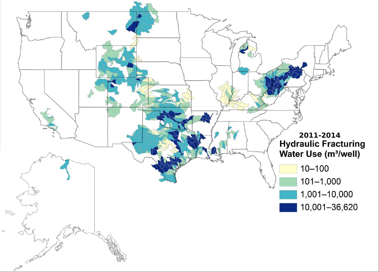
2011-2014 Hydraulic Fracturing Water Use (Meters Cubed per Well) via the USGS
Here’s the release from the United States Geological Survey (Anne Berry Wade/Leigh Cooper/Tanya Gallegos). (Multiply meters cubed used by 264.172052 to get gallons used). Here’s an excerpt:
The amount of water required to hydraulically fracture oil and gas wells varies widely across the country, according to the first national-scale analysis and map of hydraulic fracturing water usage detailed in a new USGS study accepted for publication in Water Resources Research, a journal of the American Geophysical Union. The research found that water volumes for hydraulic fracturing averaged within watersheds across the United States range from as little as 2,600 gallons to as much as 9.7 million gallons per well.
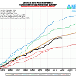
Statewide Basin High/Low Year-toDate Precipitation Summary June 29, 2015 via the NRCS
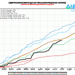
Arkansas River Basin High/Low Year-toDate Precipitation Summary June 29, 2015 via the NRCS
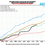
Upper Colorado River Basin High/Low Year-toDate Precipitation Summary June 29, 2015 via the NRCS
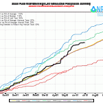
Gunnison River Basin High/Low Year-toDate Precipitation Summary June 29, 2015 via the NRCS
Laramie and North Platte Basin High/Low Year-toDate Precipitation Summary June 29, 2015 via the NRCS
Upper Rio Grande River Basin High/Low Year-toDate Precipitation Summary June 29, 2015 via the NRCS
San Miguel, Dolores, Animas, and San Juan Basin High/Low Year-toDate Precipitation Summary June 29, 2015 via the NRCS
South Platte River Basin High/Low Year-toDate Precipitation Summary June 29, 2015 via the NRCS
Yampa and White Basin High/Low Year-toDate Precipitation Summary June 29, 2015 via the NRCS
Click on a thumbnail graphic to view a gallery of data from the Natural Resources Conservation Service. Remember, the data is from SNOTEL sites so the mega-rainfall on the plains is not in the numbers.
(If the Tweet above does not display correctly use your browser refresh button. There are timing problems with content between WordPress and Twitter at times.)
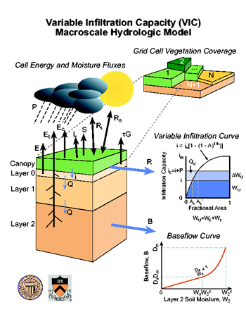
Variable Infiltration Capacity (VIC) Macroscale Hydrologic Model
Yesterday I finished up my work for the CVEN 5363 Hydrologic Modeling class at CU Boulder so now I’ll have some of my time back for blogging. I managed to get a few posts up during June and the WordPress reblog capability enabled my posting of articles from the Summit County Citizens Voice, Your Colorado Water Blog, Mile High Water Talk, and Parting the Waters. I hope that you readers will come back by now and again, now that the Ol’ Coyote is back in the publishing business.
For those of you wondering whether or not it is worth your time (and money) to take Dr. Livneh’s course I say, “Sign up for the course as soon as you can.” Its worth it as an introduction to hydrologic modeling and doubly worth it if you believe you’ll need experience with the VIC model.
Basin roundtable boundaries From the Grand Junction Free Press (Hannah Holm):
Discussions and disputes over how to meet the water needs of Colorado’s growing population typically revolve around the proper balance between taking additional water from agriculture, taking additional water from the West Slope to the Front Range, and conservation.
Conservation would seem to be the low-hanging fruit, but the nuts and bolts of how to conserve enough to avoid more transfers from agriculture or the West Slope is not as easy as it may at first appear. That scale of conservation is more than can easily be achieved simply through newer, more efficient appliances and tactics like Denver Water’s highly effective “use only what you need” campaign.
Cutting deeper into household water demands would likely require some kind of mandate, on either personal behavior or land development patterns (smaller lots equal less outdoor watering), and that flies in the face of deeply held values on private property rights and local control. From a planning perspective, it’s also harder to calculate how much water you can save from possible future changes in people’s behavior than how much water you can get from a new pipeline or water rights purchase.
These reasons played into the modest approach to conservation in the part of the first draft of Colorado’s water plan that set out “no and low regrets actions,” which are those actions that should be helpful no matter what the future brings in terms of population growth, climate change and public attitudes. This portion of the plan calls for establishing a “medium” level of conservation that would achieve 340,000 acre feet per year of water savings. An acre foot is enough water to cover an acre of land one foot deep, and it is enough to serve two to three households for a year at current use rates. Following a number of public comments and statements calling for higher conservation goals from the West Slope “basin roundtables” of stakeholders and water managers tasked with planning for their own river basins, state leaders are moving towards setting the bar higher.
On June 22, Taylor Hawes of the Interbasin Compact Committee (IBCC), which includes representatives from basin roundtables across the state, told the Colorado Basin Roundtable that the IBCC’s subcommittee on conservation was developing a “stretch goal” to achieve an additional 60,000 acre feet per year of savings for a total of 400,000 acre feet per year. Hawes reported that the committee is proposing that this goal be pursued in a way that respects local control and involves additional monitoring to determine what really works and whether the goal needs to be adjusted up or down.
Depending on how this work is received by the full IBCC and the basin roundtables, this is one of the changes that may make its way into the next draft of the Colorado Water Plan, which is due to be released in the middle of July, with a public comment period lasting until Sept. 17.
To learn more about the Colorado Water Plan and find out how to submit your own comments, go to http://coloradowaterplan.com. You can also plan to attend one of the public hearings the legislatures Water Resource Review Committee is holding on the plan. West Slope hearings will be held July 20 in Durango, July 21 in Montrose, July 22 in Craig, and Aug. 12 in Grandby.
This is part of a series of articles coordinated by the Water Center at Colorado Mesa University in cooperation with the Colorado and Gunnison Basin Roundtables to raise awareness about water needs, uses and policies in our region. To learn more about the basin roundtables and statewide water planning, and to let the roundtables know what you think, go to http://www.coloradomesa.edu/WaterCenter. You can also find the Water Center at http://www.Facebook.com/WaterCenter.CMU or http://www.Twitter.com/WaterCenterCMU.
From the Associated Press via The Greeley Tribune:
Many people pass by and marvel at its size. At 14 feet high and 546 feet long, the Grand River Diversion Dam is one of the biggest roller dams in the world, and it just turned 100 years old.
“You know you see it with those orange towers and maybe a lot of people don’t know the significance of the dam,” said Palisade Historical District’s Charlene Weidner.
“I feel like this is a great opportunity to educate people and let them know it’s an important dam.”
The six 70-foot rollers move up and down depending on the amount of water to be let through. The water is siphoned off into the Highline Canal, sending water to 33,000 acres of farms, fields, and wineries.
“We know we live in a high desert it would just be too hot to live here, because it also waters trees, so we really wouldn’t exist without it, said Weidner.
Water first turned into the canal in 1915, and a caretaker has watched after the dam day and night ever since, KKCO-TV reported.
“I love it,” said current caretaker Alfonzo Gallegos. “The sound of the waterfall, the water sloshing up against the wall here, it is a great place to be.”
Gary Hines has a special relationship with the roller dam – his grandfather was the dam’s caretaker for 33 years.
“You walk up on the catwalk above the rollers and it still gives you that massive same impression that I had 55 years ago,” said Hines. “It’s incredibly special. I was about ten years old when my grandfather unexpectedly passed away and we kind of lost our passport to this magical land.”
A unique German design, it is one of four roller dams in the country. It is too fragile and hard to access for public tours.
Click here to visit the US Bureau of Reclamation webpage for the Grand Valley Project. Here’s an excerpt:
Plan
Water for project use is diverted into the Government Highline Canal at the Grand Valley Project Diversion Dam, about 23 miles northeast of Grand Junction. Approximately 4.6 miles below the main diversion, water for the Orchard Mesa Diversion is diverted from the canal. This water passes through the Orchard Mesa Siphon under the Colorado River, through the Orchard Mesa Power Canal to the Grand Valley Powerplant, or to the Orchard Mesa Pumping Plant, where it is pumped into Orchard Mesa Canals No. 1 and 2 for distribution to the water users.
From the Orchard Mesa diversion, the Government Highline Canal continues westward, approximately paralleling the river, distributing water to laterals of the Garfield Gravity Division. Water also is furnished to 8,580 acres in the Mesa County and Palisade Irrigation Districts which were served by private facilities prior to project construction.
Facility Descriptions
Grand Valley Diversion Dam
The diversion dam is on the Colorado River about 8 miles northeast of Palisade. This concrete weir is 14 feet high and 546 feet long. Flow over its crest is controlled by six roller gates. These gates were the first of their type designed in the United States.
Government Highline Canal System
The canal is on the west and north side of the river and extends from the Grand Valley Project Diversion Dam south and west a distance of 55 miles. It has a diversion capacity of 1,675 cubic feet per second, which includes 800 cubic feet per second for the Orchard Mesa Power Canal. The remaining flows are distributed through the Government Highline Canal and Price-Stubb Pumping Plant. The distribution system for the Garfield Gravity Division consists of 166 miles of laterals. The drainage system consists of 2 miles of closed drains and 110.5 miles of deep open drains.
The Price-Stubb Pumping Plant is on the canal near Tunnel No. 3 Outlet at the east end of the Grand Valley. It lifts 25 cubic feet per second of water 31 feet to the Stubb Ditch to serve land of the Mesa County Irrigation District. Power is provided to the hydraulic pump by water delivered to the Price Ditch for the Palisade Irrigation District.
Orchard Mesa Canal System
The Orchard Mesa Siphon conveys water from the Government Highline Canal to the head of the 3.5-mile-long Orchard Mesa Power Canal on the east side of the river. The siphon is reinforced concrete with a capacity of 800 cubic feet per second. Orchard Mesa Pumping Plant lifts water from the Orchard Mesa Power Canal to the distribution system. The plant contains four pump units: two have a combined capacity of 80 cubic feet per second and a lift of 41 feet to Canal No. 1; two have a combined capacity of 60 cubic feet per second with a lift of 130 feet to Canal No. 2. Water is conveyed to privately owned and operated laterals by Orchard Mesa Canals No. 1 and 2. The canals have capacities of 85 and 65 cubic feet per second, respectively, and a combined length of 31.6 miles.
Grand Valley Powerplant
The plant is about 1 mile south of Palisade at the lower end of the Orchard Mesa Power Canal adjacent to the Orchard Mesa Pumping Plant. It operates under a maximum head of 79 feet and has a capacity of 3,000 kilowatts. The plant was constructed by the United States with funds advanced by Public Service Company of Colorado. The company operates and maintains the plant under a rental agreement with the United States and the Grand Valley Water Users Association. Power generation averages approximately 19,350,600 kilowatt-hours annually…
Development
History
Soon after their arrival in the Grand Valley in 1881, settlers began work on ditches to irrigate lowlands adjacent to the north side of the Colorado River. By 1886, the Grand Valley Canal (not part of the Grand Valley Project) was completed and the canal system expanded to serve approximately 45,000 acres of land. From 1886 to 1902, several attempts were made by private interests to construct a canal to higher lands in the valley, but because of initial technical difficulties private investors were unwilling to back the project.
Investigations
After passage of the Reclamation Act in 1902, an evaluation of the proposed Government Highline Canal, now a part of the Grand Valley Project, was requested by the local citizens. In 1905, the Grand Valley Water Users Association was organized to cooperate with the Reclamation Service in developing a project. After investigation, the Reclamation Service proposed a project consisting of a diversion dam and distribution canal to irrigate lands at higher valley levels than those being operated by private interests. A board of engineers approved feasibility of the project on December 15, 1908.
Authorization
The Grand Valley Project was one of the projects examined and reported upon favorably by a board of Army Engineers in accordance with the act of June 25, 1910 (36 Stat. 835) and approved by the President on January 5, 1911. The project was constructed primarily for agricultural and power generation purposes.
Construction
The Reclamation Service was authorized by the Secretary of the Interior on September 23, 1912, to begin construction on one of the smaller tunnels. Irrigation was first provided June 29, 1915, at which time the entire project was less than 60 percent completed. Cooperative drainage work in the Grand Valley Drainage District was begun in March 1918.
The Price-Stubb Pumping Plant was completed and water supplied through Government-constructed facilities to Palisade and Mesa County Irrigation Districts in April 1919. A powerplant was constructed in 1932-33 using funds advanced by Public Service Company of Colorado. Tunnel No. 3 on the Government Highline Canal collapsed in March 1950 because of landslides. In a dramatic effort to open the canal before the start of the irrigation season, a contract to construct a section of new tunnel to bypass the slide area was negotiated and the contractor broke all records in finishing the tunnel in time for the irrigation season.
Benefits
Irrigation
Since it first delivered water in 1917, the Grand Valley Project has furnished a full supply of irrigation water to approximately 33,368 acres and supplemental water to about 8,600 acres of fertile land. The project has made possible diversified and intensified farming in the area, regularly bringing to maturity such late-season crops as fruit, alfalfa, beans, seed, corn, oats, barley, potatoes, and wheat. Favorable climate, cheap winter forage, and proximity to good range combine to make the area desirable for profitable raising of livestock. Dairying and poultry raising are also important to the project area.
Hydroelectric Power
Grand Valley Powerplant, completed in 1933, has a capacity of 3.0 MW. The powerplant was constructed by Grand valley Water Users Association. The powerplant is operated by by the Colorado Public Service Company under a lease of power privilege contract.
FromThe Grand Junction Daily Sentinel (Bob Silbernagel ):
“Newspapers produce the first rough draft of history.” — Philip Graham
People pushing for construction of a dam in De Beque Canyon and the accompanying Government Highline Canal had overcome a variety of obstacles — opposition in Denver, foot-dragging in Washington, D.C., disputes with Orchard Mesa irrigators and a slowdown created by private entrepreneurs who claimed they could build the project without government help.
So they weren’t going to let a world war halt their plans.
Engineers working on the Grand River Diversion Dam had settled on a unique design. The “roller crest” dam would employ huge steel rollers that could be raised and lowered to maintain a constant level in the river behind the dam, and thus avoid flooding the railroad tracks beside the river.
A German company held patents on the design. However, work on the Grand Valley Project began in 1913, and by August of 1914, Germany was embroiled in World War I. The German company’s factory was not available to build the rollers.
So a firm in Pittsburgh, Pennsylvania, Ritter-Conley Manufacturing, built the steel rollers using the German design. They were delivered in the spring of 1915 and installed in the new dam, which became known as the “roller dam,” in time for the official dedication ceremony on June 29, 1915.
The Palisade Historical Society will host a celebration from 9 a.m. to 5 p.m. this Saturday at the Veterans’ Memorial Community Center in Palisade to commemorate the 100th anniversary of the opening of the dam and canal.
The historical society has also produced a booklet, “The History of Irrigation in Palisade and East Orchard Mesa, Colorado,” as part of the centennial celebration.
Work on the project went relatively smoothly, but some clauses in the contract look unusual today.
“Among the conditions of the standardized contract was the requirement … that there be no Mongolian labor used on the project,” said Priscilla Walker, with the historical society. “That was apparently standard for federal contracts at the time. I’ve looked but can’t find any information on why that was required.” The contract also prohibited importation of foreigners for labor or the use of convict labor.
There were other irrigation projects in this valley that predated the Grand Valley Project. But the project, with its roller dam and lengthy Highline Canal, would take water farther west than any of the other projects, would be more dependable than most existing projects and would bring thousands of acres of new agricultural lands into production.
The project was authorized — with $31.5 million in funding — as part of the Reclamation Act of 1902, which created the U.S. Reclamation Service. But it was one of a multitude of projects in 16 states authorized by the act, so work on it didn’t begin immediately.
Newspaper accounts from the time show the ongoing struggles by local leaders to ensure the project stayed on track.
D.W. Aupperle, then secretary of the Grand Junction Chamber of Commerce, was among the most important. He made several trips to Washington to meet with representatives of the Department of Interior and the Reclamation Service.
In a 1908 meeting of the chamber, Aupperle talked of the recently resolved conflict between backers of the Government Highline Canal project and interests on Orchard Mesa. “We take the stand that we will protect the government ditch if at the expense of the Orchard Mesa ditch, but this has not been necessary,” he said, according to the Grand Junction Daily News.
Eventually, key features of the Orchard Mesa system, including a pumping station outside of Palisade, would be incorporated into the Grand Valley Project. The Price and Stubb ditches would also obtain their water from the project.
Also in 1908, the chamber passed a resolution deploring newspaper articles in Denver that attacked the Reclamation Service in general and the Grand Valley Project in particular. “We are capable of attending to our own affairs and do not need the dictation of the papers of that city,” one chamber official said.
The project was finally given the federal go-ahead in 1912 and work began on July 1, 1913. Work on some the lateral canals that were part of the system continued into 1917.
Although the Reclamation Service — now the U.S. Bureau of Reclamation — built and owns the Grand Valley Project, the Grand Valley Water Users Association operates and maintains it.
A century later, the massive rollers manufactured in Pittsburgh continue to operate on the same gear system with the same Westinghouse electric motors to raise and lower the rollers, officials with Grand Valley Water Users Association said last week. There have been minor repairs, but it’s essentially the same system.
Thanks to the Palisade Historical Society, Grand Valley Water Users Association and the U.S. Bureau of Reclamation for their assistance.
(If the Tweet above does not display correctly use your browser refresh button. There are timing problems with content between WordPress and Twitter at times.)
Click on a thumbnail graphic to view a gallery of US Drought Monitor maps for late-June for the past 5 years.
Here’s the release from the Colorado Water Conservation Board (Taryn Finnessey/Tracy Kosloff):
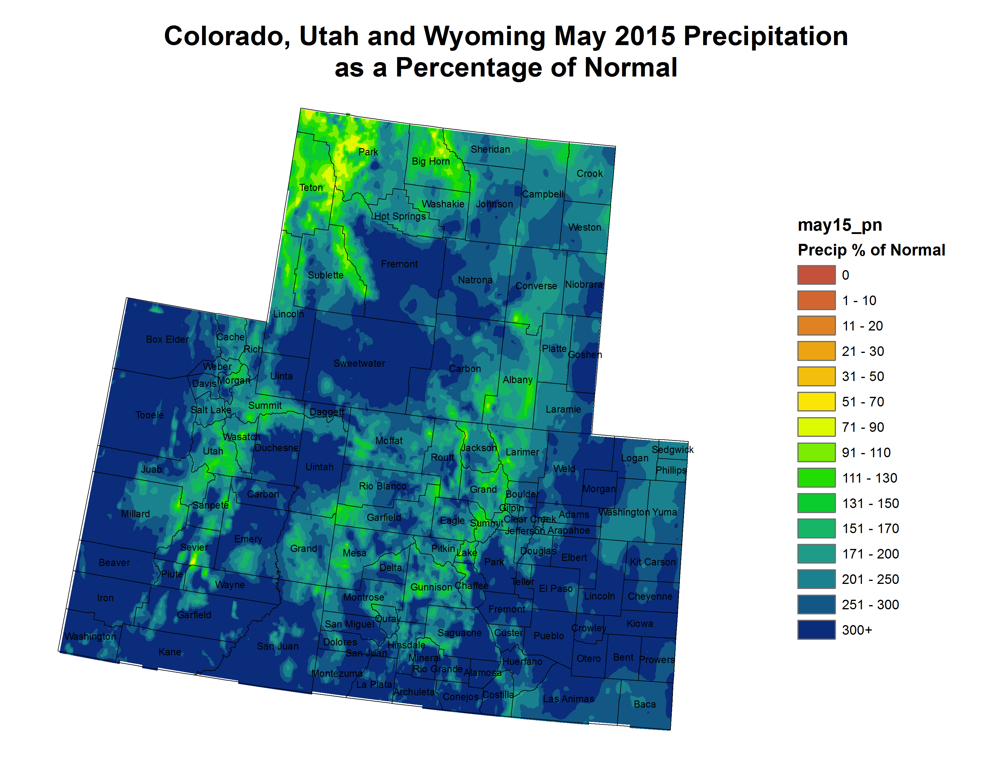
A cool and wet May has eliminated drought conditions across much of Colorado. With 31 weather stations recording the wettest month ever, statewide May 2015 was the wettest May since record keeping began in 1895. In total much of the state experienced 300% of normal May precipitation. June temperatures to-date have been slightly warmer than average and the short term forecast shows decreased likelihood of precipitation. Water providers are reporting full systems and below average demand compared to this time last year.
Water year-to-date precipitation at mountain SNOTEL sites, as of June 16, is at 97% of normal, an 11% improvement compared to the last drought update, due to record breaking May precipitation.
In the San Miguel, Dolores, Animas and San Juan river basins June precipitation to-date is 350% of normal, and has already exceeded average total June precipitation. Coupled with abundant May accumulation this region has received roughly 10 inches of precipitation since the beginning of May, leading to drought elimination in this area of the state.
Below tree-line, most basins have very little snow remaining at this time of year, although the cool and wet conditions over the last month have helped to slow melt off.
Cooler than average temperatures in May also contributed to greatly improved drought conditions, with most sites reporting below average evapotranspiration and some reporting record low evapotranspiration.
Reservoir Storage statewide is at 107% of average as of May 1st. Storage in the northern half of the state is above average with multiple basins near 110% of average. The Colorado River basin is experiencing its highest storage levels since the turn of the century. The Upper Rio Grande and the basins of Southwestern Colorado currently have the lowest storage at 66% and 89% of average, respectively. Both have seen below average storage levels for multiple years.
The Surface Water Supply Index (SWSI) is abundant in all of the South Platte, and near normal is the Colorado River, Gunnison, and Arkansas, but showing spots of moderate to severe drought in the Upper Yampa, Conejos and the Piedra. The vast majority of the state has seen improvements in the SWSI since last month.
El Niño has continued to gain strength over the last few months and is poised to become a strong event, if not a “Super El Niño.” The last “Super El Niño” was in 1997 when Colorado experienced above average precipitation.
All long term forecasting tools indicate normal to above normal precipitation in the coming months, with some indication that the monsoon season may come early.
Click on a thumbnail graphic to view a gallery of drought monitor maps for June 23, 2015.
Click here to go to the US Drought Monitor website. Here’s an excerpt:
Great Plains
Light to moderate rainfall, on the order of 0.5 to 1.5 inches, fell on most of the dry areas in the Plains, though little or no rain fell on dry areas from northern Kansas into southeastern New Mexico. A second week of significant rainfall led to reductions in the extent of D0 and D1 conditions in southeastern South Dakota and adjacent Nebraska, and there was further reduction in the D0 area still lingering in central Texas. Otherwise, conditions remained essentially as they were last week…
The Rockies To The West Coast
Little precipitation fell from the Rockies westward to the Pacific Coast last week. Overall, there was little change in conditions except along the northern tier of states from Montana westward through Washington and Oregon. Continued dryness and exceptionally hot weather kept dryness and drought increasing most significantly across eastern Washington, central and northern Idaho, and western Montana. The entire state of Washington is now covered by D0 conditions or worse, and D2 was pulled northward along the Oregon coastline, and expanded across a large part of central Idaho and adjacent Montana. These areas recorded generally 6 to 12 inches less precipitation than normal in the last 6 months, and less than half of normal amounts in the last 60 days. In contrast, recent heavy precipitation in west New Mexico and adjacent northeast Arizona led to additional improvements in these areas despite the dry week…
Looking Ahead
For the upcoming 5-day period (June 25-29), hot and dry weather should prevail west of the Rockies’ front range, except in parts of the desert Southwest. Little if any precipitation is expected, and daily high temperatures from Utah and Nevada northward through the northern Rockies and Intermountain West will average 9 to 18 degrees F above normal, with even higher departures possible along the east side of the Cascades. Near normal temperatures and light to moderate precipitation are forecast for the Plains and southeastern Rockies, with over an inch of possible in the higher elevations of south-central Colorado and adjacent New Mexico. Light to moderate rain is also expected across the Great Lakes and northern New England, along with cooler than normal temperatures (daily highs should average 3 to 6 degrees F below normal). Moderate to heavy rainfall, generally exceeding an inch, is expected from the Midwest, Ohio Valley, and lower Northeast southward through the Gulf Coast and Florida. Over an inch of rain is anticipated everywhere except parts of Florida, with 2 to 5 inches potentially falling on the Ohio Valley, central to northern Appalachians, and mid-Atlantic region.
For the ensuing 5-day period (June 30 – July 4), continued above normal temperatures are favored in most of the West and across the Gulf Coast and southern Atlantic regions, including Florida. Meanwhile, the odds favor anomalously cool weather from the Plains eastward through the upper Southeast, Ohio Valley, Great Lakes, and interior portions of the mid-Atlantic and Northeast. Drier than normal conditions are favored across Florida and in a swath from the northern Plains to the Pacific Northwest. Enhanced chances for above-normal precipitation cover a large part of the rest of the contiguous 48 states, excepting California, the central Gulf Coast, and in a stripe from the northern Intermountain West eastward through the Dakotas and Minnesota, south of the area where subnormal precipitation is favored. Warm weather is anticipated over most of Alaska, with enhanced chances for above normal precipitation identified outside the Panhandle and east-central parts of the state.
Click here to go to the US Drought Monitor website. Here’s an excerpt:
Great Plains
Only a few areas of dryness and drought remain in the Great Plains following the deluges of the last 1 to 2 months. It was wet again this past week, with most sites from the western Dakotas and northern Nebraska southward through central and southeast Texas recording at least an inch of rain. The heaviest amounts (2 to over 6 inches) fell on portions of upper southeast Texas, and in a broad swath from northwestern Texas and most of Oklahoma northeastward through southern and east-central Kansas and eastern Nebraska.
D1 and D0 coverage again declined as a result, with improvements in southwest Kansas and parts of the Oklahoma and Texas Panhandles. Despite the heavy rains in what is now the driest part of the Plains (southeastern South Dakota and northeastern Nebraska), satellite-derived estimates still showed low levels of groundwater and root zone moisture, and vegetative health remained stressed by dryness. As a result, no changes were made this week.
There were also no changes in the other regions of dryness in the Plains, where the week’s weather was relatively nondescript…
The Rockies To The West Coast
Unseasonably heavy rains fell again this week across a swath from west-central Nevada through portions of Utah, southernmost Idaho, western Wyoming, southwestern Colorado, and adjacent Arizona and New Mexico, partially from tropical cyclone remnants. The rains of the current and past few weeks led to some broad areas of improvement, most notably interior west-central Nevada (to D3), northeastern Nevada and adjacent Idaho and Utah (to D0 in one area), and a broad portion of the Four Corners region. Farther north and west, however, dryness and warmth led to degradations in part of western Oregon, northern Idaho and adjacent Montana, and a few other small patches.
Although this week finally brought an end to the protracted period of D4 conditions entrenched in west-central Nevada, it should be noted that water supplies were practically unaffected by the recent precipitation, remaining alarmingly low. Cutbacks in water availability were not changed, and thus agriculture (which is irrigated) continued to suffer without respite. However, amounts were so unusual that precipitation totals for the last 2 years have moved near to above normal in part of the region. As a result the landscape is looking greener than it has in a long time, and across the state, only 25% of pastureland was short or very short of moisture, the lowest total since October 2011…
Looking Ahead
For the upcoming 5-day period (June 17-21), generally dry and significantly warmer than normal conditions are expected in the central Plains and from the Rockies westward to near the coast. roughly the western half of the country. Only isolated light rain at best is anticipated in areas south and west of Montana and the central sections of Wyoming, Colorado, and New Mexico. Forecast totals in eastern and northern parts of the Rockies are less than 0.5 inch. At the same time, daily high temperatures are expected to average 9 to 12 degrees F above normal in the Great Basin and central Rockies. The dryness and heat may quickly dry out the recent surface growth in that region, bringing ideal conditions for wildfires to develop and rapidly spread.
In contrast, remnants of Tropical Storm Bill should bring a swath of heavy rain across east sections of Texas and Oklahoma, southern Missouri, the Ohio Valley, the central Appalachians, and (to a lesser extent) part of the lower Northeast. At least a couple inches of rain is expected, with peak amounts approaching 7 inches in southern Oklahoma, and 4.5 to 5.5 inches in southern sections of both Illinois and Ohio.
In the broad area north of this swatch, moderate rains of several tenths to almost not quite 2 inches are expected. Drier conditions are forecast to prevail south and east of the band of heaviest rainfall, with only a few tenths of an inch anticipated in Florida, the central Gulf Coast States, and southwestern South Carolina.
For the ensuing 5-day period (June 22-26), continued above normal temperatures are favored in most of the West, the Rockies, and the Southeast. The odds favor anomalous warmth in the mid-Atlantic, central Appalachians, middle and lower Mississippi Valley, and south-central Plains as well. Enhanced chances for cooler than normal weather are limited to a swath from the northeasternmost Plains eastward through the northern Great Lakes and much of the Northeast. In Alaska, the odds favor above normal temperatures everywhere except the northern fringe of the state, with odds for warmth progressively increasing southward.
Enhanced chances for heavier than normal rain cover the Great Lakes and Northeast, and a small area around the southern reaches of the Arizona/New Mexico border. However, dryness is favored to prevail from the south-central Plains eastward through the lower Mississippi Valley and the Southeast. The northwestern quarter of the contiguous states also has increased odds of abnormally light precipitation, as does all of Alaska outside the Aleutians and adjacent southwestern areas.
Click here to go to the US Drought Monitor website. Here’s an excerpt:
Summary
The NCEI (formerly NCDC) May 2015 precipitation total for the contiguous U.S. was the wettest May and month of any month in the 121-years of record keeping. State-wise, it was the wettest May in Texas, Oklahoma, and Colorado, and one of the top 5 wettest Mays in Utah, Kansas, Wyoming, Arkansas, and South Dakota. With those statistics, it is not surprising that nearly all drought from late March has been eliminated in the Plains, Midwest, and central Gulf Coast. In addition, wet spring weather in the Great Basin and Four Corners Region has continued into June, necessitating improvements to parts of these areas. During this week, stalled or slow-moving cold fronts in the north-central Plains and along the southern Atlantic and eastern Gulf Coasts triggered scattered showers and thunderstorms, some locally heavy, in parts of the northern and central Plains, upper Midwest, central Corn Belt, and from the Delmarva Peninsula southward into Florida. During the weekend, moisture from the remnants of eastern Pacific Hurricane Andres was pulled into the Southwest, producing light to moderate showers in central Arizona, southeast Utah, southwest Colorado, and New Mexico. Late in the period, additional moisture from former Pacific Hurricane Blanca streamed northward, poised to generate additional showers in the Southwest, including California. As the slow-moving cold front finally tracked far enough eastward, light to moderate rains fell on the eastern Tennessee Valley, mid-Atlantic, and western New England. Dry weather finally allowed the southern Plains to recover from weeks of copious rains and severe flooding, with mostly dry weather also occurring in the lower Mississippi and western Tennessee Valleys. Mostly dry weather continued in drought areas of Puerto Rico and Hawaii, but decent rains (2 to 8 inches) finally returned to the southeastern Panhandle of Alaska…
Great Plains
Moderate to heavy rains were reported across portions of the northern and central Plains, including a band of 4-8 inches in southeastern Nebraska, northeastern Kansas, and northwestern Missouri. Additional improvements were made where the rains (generally more than 2 inches) erased or greatly diminished 60-, 90-, or 180-day deficits, and this encompassed eastern Montana and western North Dakota, southeastern South Dakota and northeastern Nebraska, southwestern and southern Nebraska, small sections of D0 and D1 in western Kansas and the Panhandles of Oklahoma and Texas, and in north-central Oklahoma. In Texas, mostly dry weather aided flood recovery efforts to continue, allowing for a re-assessment of conditions with more stable reservoir levels that required some changes to the D0 areas in west-central Texas. As of June 10, Texas monitored water supply reservoirs stood at 83.6% full, with some reservoirs still less than 40% full in Coke, Tom Green, and Mitchell counties – hence the lingering D0(L) near the San Angelo area. Additional decent rains should be enough for continued improvements in the Dakotas and Nebraska, but longer-term hydrologic drought conditions (e.g. low reservoirs) will require a longer span of surplus rains (inflow) to alleviate…
The West
Moisture from the remnants of Pacific Hurricane Andres triggered showers and thunderstorms in the Four Corners region, including 0.5-3 inches in central and northeastern Arizona, southeastern Utah, southwestern Colorado, and most of New Mexico. Light showers (less than 0.5 inches) also fell on parts of the Great Basin. With much of this region experiencing an unseasonably cool May and wet spring (out to 90-days) after a warm and dry winter, some impacts from this cool and wet weather have been recently observed. SPI values have become “wetter” out to 12- and 24-months in normally semi-arid locales (e.g. Nevada, Utah, Arizona, New Mexico) as have other tools and products. This makes sense as long-term drought is less severe as one moves east from California (and precipitation normally decreases). To represent this, some 1-category improvements were made in areas where the largest totals and 90-day surpluses were located, along with visible impacts. This included central (D1 to D0) and northeastern (D3 to D2) Arizona, southeastern Utah and southwestern Colorado (D1 to D0), northwestern Utah (D3 to D2), northeastern Nevada and south-central Idaho (D2 to D1), and a small area of west-central Nevada (D4 to D3, Pershing County). In the latter area, however, agriculture still depends on irrigation from upstream reservoirs or ground water pumping, and this water source has not improved with the recent rains as Rye Patch reservoir was at 9% of its average storage on May 31. This has resulted in little or no water deliveries and many fallow fields – but based strictly on the area’s current soil moisture, nearly all indicators pointed toward D3. Impacts farther east near Elko were more numerous and included 3-7 inches of May rain and continuing rains into June, widespread thick grass growth, recharge on formerly dry springs, and dirt tanks collecting runoff. Unfortunately, this build-up of vegetation will lead to extra fuel for late summer and fall wildfires if hot and dry weather returns and cures the vegetation. But for now, the recent rains and cool weather have improved pastures and range ratings into good to excellent categories on June 7. This included: California (35%), Nevada (50%), Utah (65%), Colorado (57%), New Mexico (49%), and Arizona (43%), according to USDA/NASS.
In contrast, another week of unseasonably warm and dry weather, in addition to a dry spring (and dry and warm winter), has lowered USGS monitored 28-day averaged coastal streams to near- and record lows in California’s Humboldt and Mendocino Counties – that count on spring rains for flow – from D2 to D3. Similarly, along coastal Oregon and Washington, 28-day average USGS streams have also fallen below the tenth percentile, and D1 was expanded to account for the low values. In the Olympic Peninsula of Washington, precipitation deficits have increased out to 60-days, and record low stream flows have surpassed the previous low flows in 2001, including trenching on the Siebert Creek to aid salmon migration. Accordingly, D1 was expanded to include the Olympic Peninsula…
Looking Ahead
For the upcoming 5-day period (June 11-15), moderate to heavy precipitation (1.5 to 4 inches) is expected from the central Rockies and south-central Plains northeastward into western New England. Light to moderate rains are also predicted along the central and eastern Gulf Coast, while unseasonable rains (up to 1.5 inches) are forecast for the Sierra Nevada and Great Basin. Moisture from the remnants of Pacific Hurricane Blanca triggered showers across most of the Southwest (including California) on June 9 and 10. Elsewhere, little or no rain is expected in the Northwest and desert Southwest, with only light totals in the southern Great Plains, Tennessee Valley, and along most of the Atlantic Seaboard (except Florida). 5-day temperatures should average above normal in the Far West, northern Rockies and Plains, Ohio Valley, and mid-Atlantic. Subnormal readings are expected from the Southwest northeastward into the Great Lakes region, with seasonable temperatures elsewhere.
For the ensuing 5-day period (June 16-20), the CPC 6-10 day precipitation outlook favors above-median chances in the Nation’s midsection (Plains and Midwest) and Northeast, with sub-median precipitation likely in the Northwest, Southeast, and across southern Alaska. Above normal temperatures are favored in most of the lower 48 States and Alaska, with subnormal readings likely in the Pacific Northwest.
Greg Hobbs at the 2015 Martz Summer Conference (of course there is a projected image of a map — this one was the division of Colorado into water divisions heeding the advice of John Wesley Powell to organize by watershed)
@CoyoteGulch how to avoid privatization of public resource a la Kern County water bank is necessary regulatory wrinkle to iron out
(If the Tweet above does not display correctly use your browser refresh button. There are timing problems with content between WordPress and Twitter at times.)
In Colorado we have prior appropriation, the anti-speculation doctrine, and a long-lived and active water market, that have managed to keep the wolf at bay. Maximizing shareholder value is the wrong goal for the public’s water. Most water in Colorado is provided by local government entities.
Municipal use is a small part of the overall pie but large amounts of water are necessary for agriculture and the environment. You don’t want to squeeze either one too much. We’re not that good at forecasting the consequences of our engineering.
I asked Brad Udall if he thought the Colorado River Basin was in collapse. He said no, even in the worst case we should have 80% yield from the system. He said we have to use the water more wisely.
That is the definition of collapse: There is not enough water to stay status quo in the basin. This is at the same time that the environment requires that we undo some of our damage and share some water.
Click here to read my notes (Tweets) from the conference. (Scroll down to the bottom and read up from there. Tweets are published in reverse-chronological order.)
Paolo Bacigalupi writes, in the acknowledgement section of his new book, “The Water Knife“:
Others I’d like to thank because I had a chance to lurk over their shoulders on Twitter include Charles Fishman @cfishman, John Fleck @jfleck, John Orr @CoyoteGulch, Michael Campana @WaterWired, and the water news site @circleofblue, not to mention the many other individuals and organizations who drop stories and tidbits into hashtags like #coriver, #drought, and #water.
Thanks for the shout out Paolo, it means a lot. What a cool thing, Twitter for research and context.
WATER IS POWER
Paolo Bacigalupi, “New York Times” best-selling author of “The Windup Girl” and National Book Award finalist, delivers a near-future thriller that casts new light on how we live today and what may be in store for us tomorrow.
The American Southwest has been decimated by drought. Nevada and Arizona skirmish over dwindling shares of the Colorado River, while California watches, deciding if it should just take the whole river all for itself. Into the fray steps Las Vegas water knife Angel Velasquez. Detective, assassin, and spy, Angel cuts water for the Southern Nevada Water Authority and its boss, Catherine Case, ensuring that her lush, luxurious arcology developments can bloom in the desert and that anyone who challenges her is left in the gutted-suburban dust.
When rumors of a game-changing water source surface in Phoenix, Angel is sent to investigate. With a wallet full of identities and a tricked-out Tesla, Angel arrows south, hunting for answers that seem to evaporate as the heat index soars and the landscape becomes more and more oppressive. There, Angel encounters Lucy Monroe, a hardened journalist, who knows far more about Phoenix’s water secrets than she admits, and Maria Villarosa, a young Texas migrant, who dreams of escaping north to those places where water still falls from the sky.
As bodies begin to pile up and bullets start flying, the three find themselves pawns in a game far bigger, more corrupt, and dirtier than any of them could have imagined. With Phoenix teetering on the verge of collapse and time running out for Angel, Lucy, and Maria, their only hope for survival rests in one another’s hands. But when water is more valuable than gold, alliances shift like sand, and the only truth in the desert is that someone will have to bleed if anyone hopes to drink.
About the Author
Paolo Bacigalupi’s debut young adult novel, Ship Breaker, was a Michael L. Printz Award winner, a National Book Award Finalist, and a Locus Award winner. His debut adult novel, The Windup Girl, was named by Time Magazine as one of the ten best novels of 2009 and won the Hugo, Nebula, Locus, Compton Crook, and John W. Campbell Memorial Awards. His short-story collection, Pump Six and Other Stories, was a 2008 Locus Award winner for Best Collection and was also named one of the Best Books of the Year by Publishers Weekly. He lives with his wife and son in western Colorado.
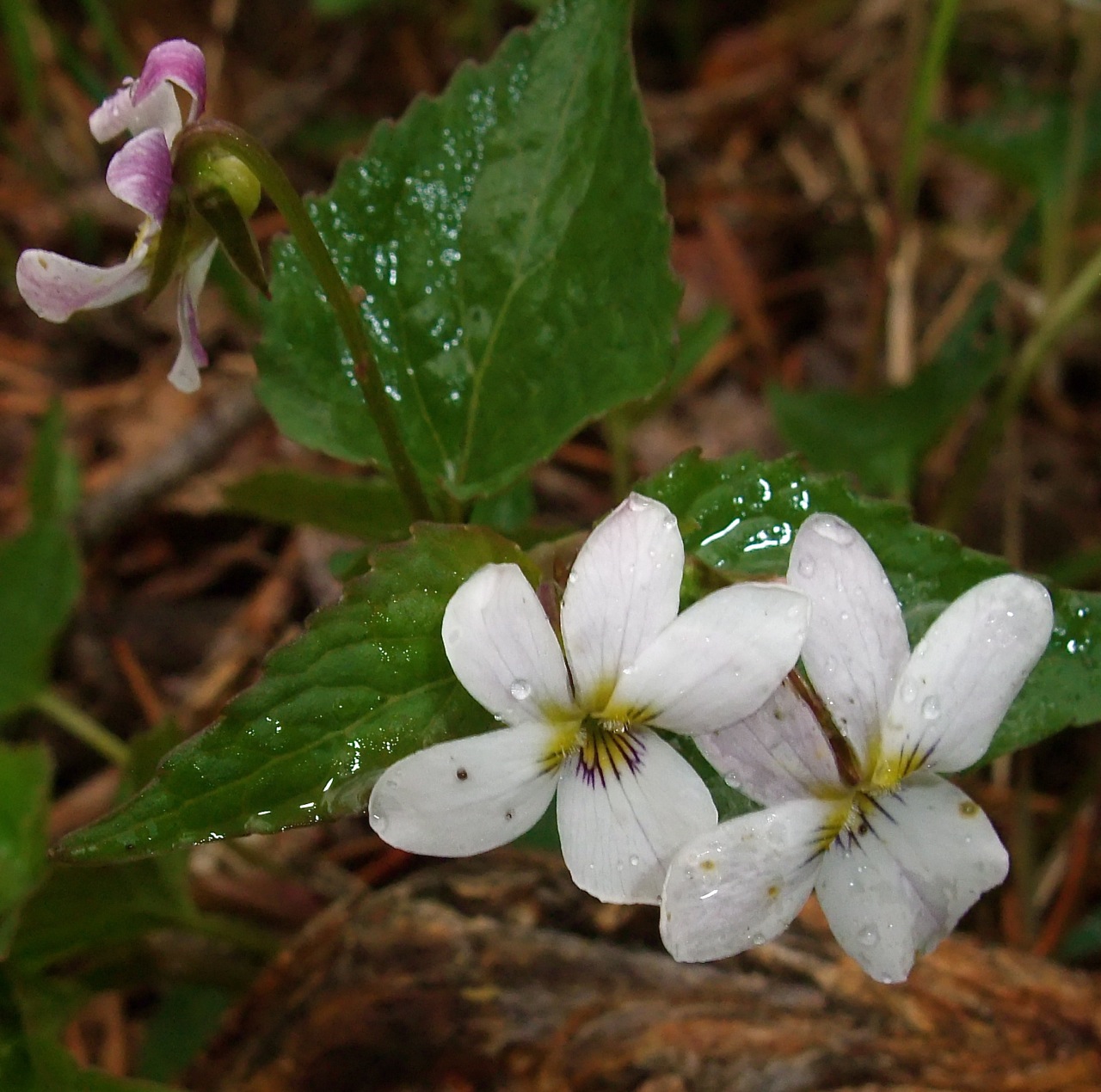
White violets along a trail near Frisco — Photo via Bob Berwyn
The first day of the conference was so much fun — great conversations during the networking sessions, well-prepared and interesting speakers and a Twitter-fest. I’ll be live-Tweeting again today @CoyoteGulch.
Click here to view my day 1 notes (Tweets). I fat-fingered the hash tag during the presentation on the Salton Sea. To see those Tweets click here.
Click here to read the latest discussion. Here’s an excerpt:
Synopsis: There is a greater than 90% chance that El Niño will continue through Northern
Hemisphere fall 2015, and around an 85% chance it will last through the 2015-16 winter.
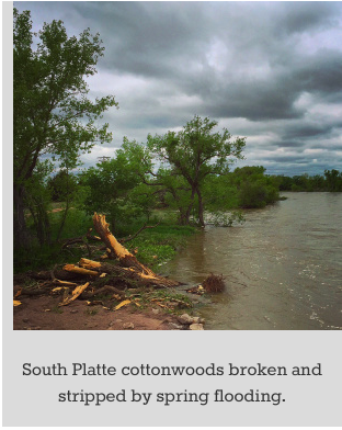
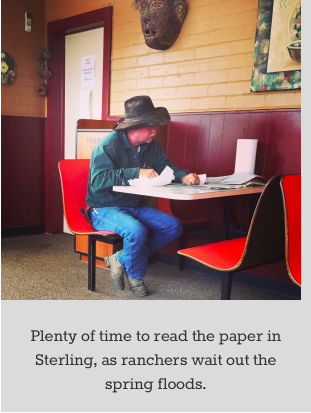
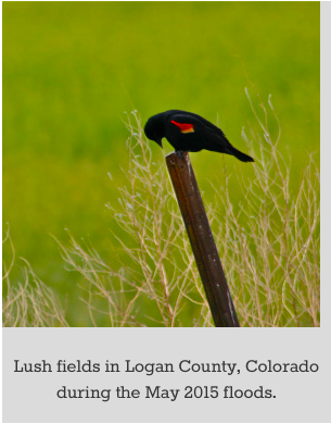
The South Platte River is running big this year, and the mud in the fields around Sterling is boot-deep. Water is everywhere, overflowing levees near the pastures, corn and hayfields north of town. The swales along roadsides and railroad tracks are swamped, and backyards are squishy, so the ranchers are in the coffee shops, waiting it out.
“Too wet to get in the fields,” a ranchhand says over a Baja burger at the drive-in. “But we’ve had plenty of dry years lately … 2012, it got really bad,” he says, referring to the over-heated summer three years ago that baked all of Colorado. Demand for water soared, sapping supplies so fast that the gauges couldn’t keep up.
“But right now, it’s hard to believe you could run out of water,” he says, shaking his head at the giant puddles around his muddy truck outside.
Along the highway, the brawny, braided river has swamped giant cottonwoods, stripping the bark clean off and leaving 15-foot stumps. It may be too muddy for tractors, but the red-winged blackbirds are loving it, plucking fat worms out of the soggy ditches.
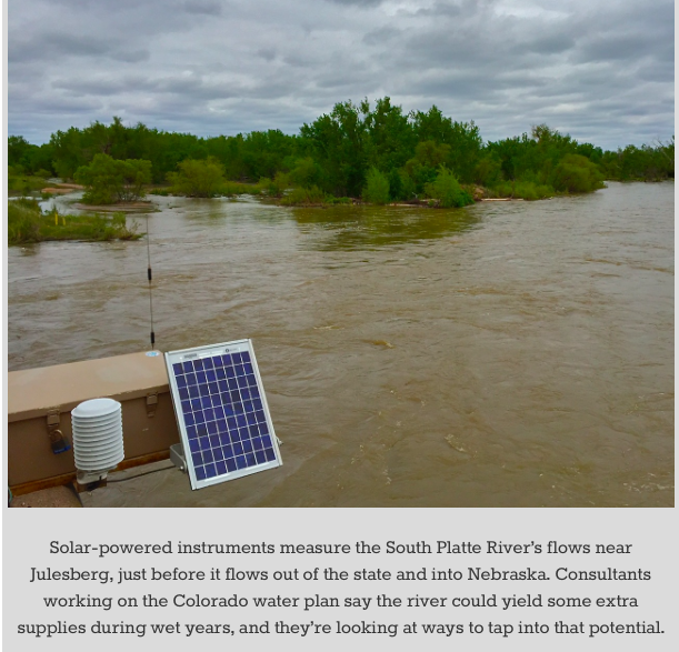
And across town, on the high ground of the local golf course, other water watchers, armed with Powerpoints and iPads, also talked about the surging South Platte. Tapping some of those high flows could help prevent the mid-century water shortage projected by state planners.
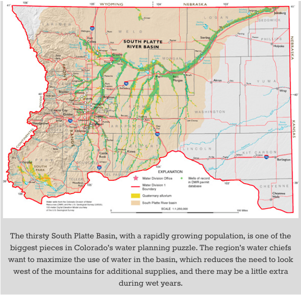
The population of the South Platte River Basin – Denver, Boulder, Fort Collins, Longmont and Greeley – may double in size in the next 35 years. A draft version of Colorado’s developing water plan says there just won’t be enough water for all those people, let alone farmers and ranchers out on the Plains, who are always worried the cities will siphon off the rivers before the water reaches the fields.
Channeling some of the water into reservoirs away from the main stream could be a way to boost supplies for the entire South Platte Basin, said Joe Frank, general manager of the Lower South Platte Water Conservancy District.
“We need to see a few more buckets and infrastructure. We’re in the heart of it here in Sterling,” Frank said, referring to the constant tussle over water between ranchers and farmers and the big Front Range cities of the South Platte Basin.
Working River
The 22,000-square-mile South Platte Basin starts up high at the Continental Divide in South Park and encompasses beloved tributary streams that are household names in Colorado: the Big Thompson, Cache la Poudre, and St. Vrain rivers; and Boulder, Clear, and Cherry creeks.
By the time the South Platte flows into Nebraska at Julesberg, it has earned its reputation as Colorado’s hardest working river, for supplying drinking water to millions and sustaining tens of thousands of acres of hay and corn fields and huge tracts of grazing. Most of what is grown is fed to cows at regional dairies and ranches.
The water plan, ordered by Gov. John Hickenlooper in 2013, is nearing completion, with a final draft due July 15. Filling the projected water shortage is a key goal.
The plan relies heavily on regional versions from nine major river basins included in the plan: the Arkansas, Colorado, Gunnison, Metro, North Platte, Rio Grande, South Platte, Southwest and the Yampa/White.
The new statewide plan will build on about 10 years worth of planning in those basins, each facing distinctive challenges. The Rio Grande Basin, for example, is concerned about erratic forecasts for stream flows that make allocating water more difficult, while the people in the Yampa Basin worry that water could be taken out of their beloved free-flowing river.
The huge projected gap in the South Platte Basin may be the biggest nut to crack, but it can be done. New water pipelines and reservoirs could help, but the state’s numbers show that a focus on massive water savings and modernization in cities and on farms can go a long way to ensuring the sustainable water future sought by the plan.
And if a proposal for a new project from one of the basins can do the nearly impossible, by helping cities, factories, farms and the environment, it could be targeted for state support, in the form of grants or legislation, as part of the final plan.
Historically, the South Platte Basin has looked outside its own boundaries, bringing in massive quantities of water from west of the Continental Divide, but this is a new era, according to water experts who helped shape the South Platte Basin’s regional plan.
That means finding water within the basin that hasn’t already been claimed by someone else, said consultant Matt Cook. Another option would be to enlarge existing reservoirs, like Empire, near Wiggins — but any of those projects would need some type of pumpback system to bring water where it’s needed, he said.
As part of the regional talks leading up to the statewide plan, farmers and cities have already had some preliminary discussions, said Jim Yahn, a farmer from the Sterling area who serves on the board of the local irrigation district.
Along with increasing supplies for cities, water from the South Platte River could also boost the fortunes of farmers around Sterling all the way to the Nebraska border, where there are tens of thousand of acres of fertile land that don’t have access to irrigation water, Yahn said.
“It all sounds good, but basically, we’re just trying to hold our own for agriculture,” Yahn said. “The real money would come from municipalities,” he added, acknowledging the huge cost of building new reservoirs and pipelines.
Yahn said there are also some technical challenges. When the river is high, there’s no way to use existing equipment to take more water, he said.
“Us ag people look at this all the time. The farmers need to be as one,” he said.
Featured image: Bob Berwyn. High flows in the South Platte River inundate farmlands near Sterling during the wet spring of 2015.
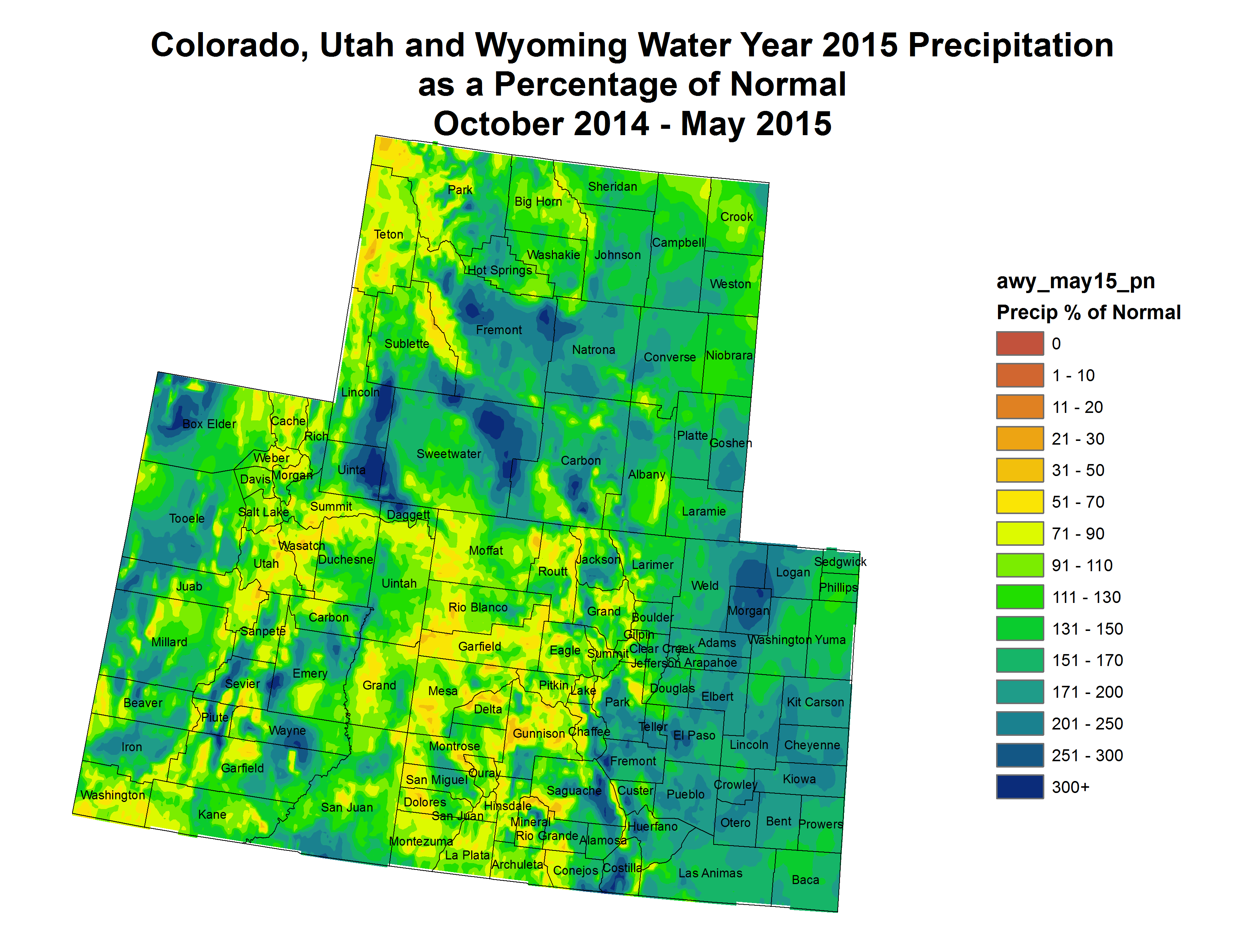
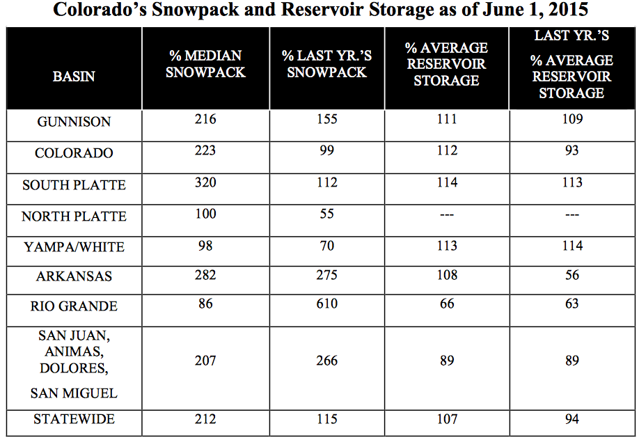
Here’s the release from the Natural Resources Conservation Service (Brian Dominos):
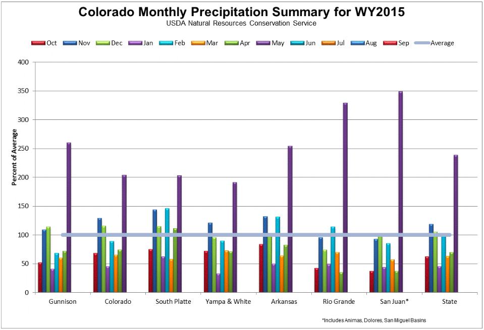
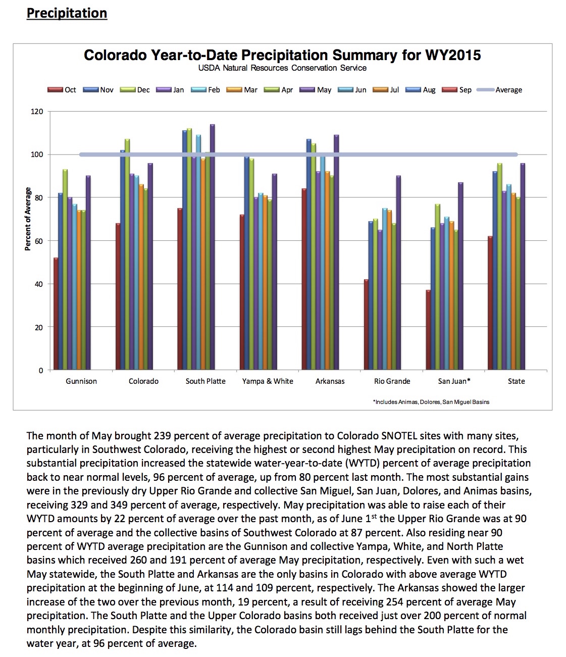
The month of May produced an impressive 239 percent of average precipitation across the mountains of Colorado, a welcome change from the two previous months of below average precipitation. This precipitation combined with cool temperatures at high elevations allowed for a prolongation of the snowpack during a time of year when snowmelt is often already well under way. “This substantial addition of moisture, both in the form of snow and rain have notably increased water supply forecasts across the state from a month ago,” comments Brian Domonkos, Colorado Snow Survey Supervisor.
While this additional moisture helped to increase water supply for the upcoming summer statewide it was a particularly welcome addition to the basins of south central and southwest Colorado. The Upper Rio Grande and combined Sam Miguel, Dolores, Animas, and San Juan basins received well over three times the normal amount of May precipitation, at 329 and 349 percent of average, respectively. These amounts were the highest on record for most SNOTEL sites across the San Juan Mountains in the month of May. While the snowpacks in these basins never reached their median peak values these late additions to the snowpack will help provide notably more water to the area, and for longer into the summer than previously expected.
While the exceptionally wet May was great news for many parts of Colorado from a water supply standpoint, there is a flip side, particularly in areas with the most snow remaining. Having a substantial amount of snow in the mountains as temperatures continue to rise, and the probability of rain on snow events, increases the risk of flooding resulting from accelerated snowmelt. These events depend on a variety of combined factors but are something to be aware of as a possibility in the coming weeks.
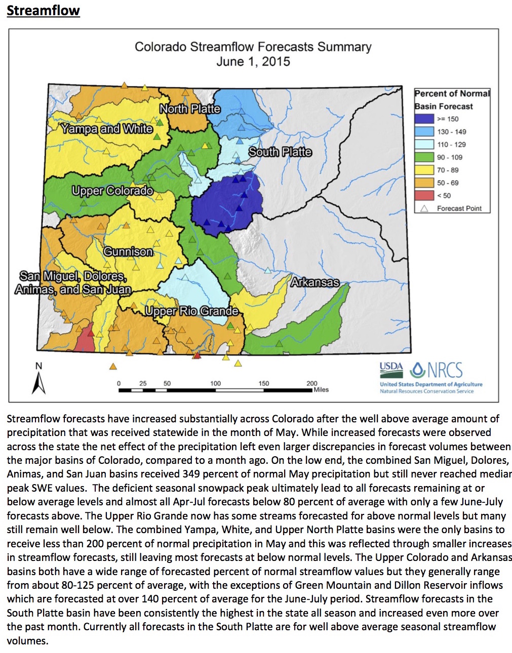
Snow and precipitation aside, reservoir storage across the state remains very similar to last month statewide, at 107 percent of average, with most basins showing only modest changes from last month. The Arkansas basin reservoirs were the main exception to this, showing a very large increase from 79 to 108 percent of average over the last month. Streamflow forecasts, however, are a different story. While there was a net increase from last month across the state the largest increases were seen in the basins of the northern Front Range, which already had the most plentiful forecasts in the state (not to mention the entire Western U.S.), even further widening the gap between those and forecasts in the Upper Rio Grande and combined San Miguel, Dolores, Animas, and San Juan basins of Southwest Colorado.
Click here to go to the US Drought Monitor website. Here’s an excerpt:
Summary
A series of cold fronts moving southeastward out of the Canadian Prairies brought additional moderate to heavy (more than 2 inches) rains to the water-logged southern and central Plains, including most of Kansas, Oklahoma, and Texas, along with beneficial moisture to the northern Plains and Midwest, early in the period. Based upon estimated monthly state rainfall totals, May 2015 was the wettest month ever in Texas (8.81 inches) and Oklahoma (14.27 inches), incredibly ending the region’s long-term drought within 4-6 weeks (but causing widespread flooding). Over the weekend as a strong cold front finally pushed eastward, the southern half of the Plains finally cleared out while much of the Southeast, mid-Atlantic, and New England reported welcome showers and thunderstorms which ended the unseasonable warmth and eased short-term dryness. Dry conditions and increasing temperatures returned to the Southwest after an unseasonably cool and wet May that led to unexpected green-up of ranges and pastures in parts of southern and eastern California, Nevada, and western Arizona but did nothing to ease the long-term drought, and most-likely added extra fuel for late summer and early fall wildfires once the vegetation dies off. Light showers were enough to keep the Pacific Northwest at status-quo, while a very warm and record dry May (after a wet April), along with little to no spring snowpack, was enough to expand D0 along the southeastern Panhandle of Alaska. Continued subnormal rains across eastern Puerto Rico and low stream flows justified expansion of D0 and D1, and the addition of D2…
Great Plains
The incredible southern Plains drought relief continued this week, although the weekly rainfall amounts “decreased” from copious to heavy, and clear skies finally prevailed later in the period. Still, more than 2 inches of rain fell on parts of the Dakotas, western Nebraska, western and eastern Kansas, eastern Oklahoma, and most of Texas except for the Panhandle and southwest. The week’s heaviest rains fell around the Dallas-Ft. Worth region, with locally up to 8 inches. Based upon estimated monthly state averages, May 2015 was the wettest month ever for Texas (8.81 inches) and Oklahoma (14.27 inches), breaking both the former state monthly records by several inches. This has alleviated long-term drought within 4-6 weeks, but unfortunately produced widespread severe flooding. Monitored Texas water supply reservoirs were 83.4% full on June 3, whereas 6-months ago they were at 62.5% full. A few reservoirs in the Panhandle and west-central Texas were still below normal (where D0 and one small D1 area was kept), but nearly every reservoir in the eastern half of the state was close to capacity. With the continued moisture, decreasing or eliminated long-term deficits, and increasing short-term surpluses, 1-category improvements were made across much of Texas, Oklahoma, western and southern Kansas, southeastern Colorado, eastern South Dakota, and northeastern and southwestern North Dakota. Where lighter rains fell (north-central Oklahoma, south-central Kansas, eastern Nebraska, and south-central South Dakota), conditions were maintained. D0 was slightly expanded in northwestern North Dakota (Mountrail County) where long-term dryness still lingered…
The West
Seasonably drier and warmer weather returned to the West after unseasonably cool and unsettled conditions occurred during the first 3 weeks of May. As a result, May recorded above-normal precipitation (except along the Pacific Coast) and well below-normal temperatures (except in the Pacific Northwest). With May precipitation normally low, it didn’t take much rainfall to produce well-above normal percentages (e.g. San Diego, CA obs=2.39”, normal=0.12”). An unusual effect of the cool and wet May weather was a green-up of pasture and range vegetation in southern and eastern California and Nevada where extreme to exception drought is widespread and ongoing. Although California and Nevada pasture and range conditions were rated 35% and 50% good or very good on May 31 by the USDA, no improvements were made to the drought depiction as long-term (4-year drought) hydrologic conditions remained dire. In fact, the green-up of vegetation and sprouting of grasses will most-likely provide extra fuel for wildfires once the vegetation dies off later this summer. To depict the short-term wetness, the impact line between SL and L was drawn where May was wet (L-only) versus May was dry (SL) from central Washington southward into southern California. In western and central San Bernardino County, the May rains missed this desert region, and with conditions similar to areas to the immediate west, D3 was expanded into this county. In southwestern Montana, areas west of the divide did not receive the May rains that east of the divide enjoyed, thus D0 was expanded into this region. In contrast, areas east of the divide and north of Yellowstone saw excess May rains, and D1 and D0 was trimmed away there. Elsewhere, no changes were made as light precipitation across the Northwest and eastern Great Basin was enough to maintain status-quo…
Looking Ahead
For the upcoming 5-day period (June 4-8), decent precipitation should occur across the Great Basin, north-central Rockies, central and northern Plains, most of the Midwest and Great Lakes region, and along most of the southern Atlantic Coast States (from Florida northward into Virginia). Little or no rainfall is expected in the Far West, Southwest, southern third of the Plains, and coastal New England. Temperatures should average above-normal in the Northwest, southern half of the Plains, middle and lower Mississippi, and Ohio Valleys. Elsewhere it should be near or slightly below normal.
For the ensuing 5-day period (June 9-13), the CPC 6-10 day outlooks, odds favor above-median precipitation in the Southwest, Great Basin, central Rockies and Plains, eastern third of the Nation, and northern Alaska, with subnormal precipitation likely in the Northwest, northern and southern Plains. Above-normal temperatures are favored in the West, northern Plains, and in the Southeast and along the Eastern Seaboard, with subnormal readings limited to central Alaska.