This summer, more than 20 NOAA scientists will stay up late to learn why some thunderstorms form and grow at night, without the energy from the sun’s heat. They will be participating in the Plains Elevated Convection At Night (PECAN), a large, intensive field campaign to collect data before and during nighttime thunderstorms in the western Great Plains from June 1 to July 15.
PECAN researchers will deploy instrumented aircraft, ground-based instruments, mobile radars, and weather balloons to learn what triggers these storms, how the atmosphere supports their lifecycle, and how they impact lives, property, agriculture and the water budget in the region. Meteorologists believe these targeted observations will build understanding and ultimately improve forecasts of these sometimes damaging storms.
“Large nighttime thunderstorms are an essential source of summer rain for crops, but also produce widespread and potentially hazardous severe weather, excessive rainfall, flash flooding, and unusually frequent cloud-to-ground lightning,” said Conrad Ziegler, a research meteorologist at the NOAA National Severe Storms Laboratory and principal scientist for PECAN. “Weather forecast models often struggle to accurately account for these. The PECAN field campaign will provide us with valuable insights—and improve our ability to save lives and property through more accurate forecasts.”
The PECAN field campaign will involve scientists, students, and support staff from eight research laboratories and 14 universities. The $13.5 million project is largely funded by the National Science Foundation (NSF), which contributed $10.6 million. Additional support is provided by NOAA, NASA, and the U.S. Department of Energy.
Nighttime storm triggers
Once the sun goes down, the Earth and its lower atmosphere usually loses heat and becomes more stable, an environment not so favorable for supporting thunderstorms. In the Great Plains, however, many summer storms form after sunset, and sometimes without an obvious trigger.
PECAN scientists are interested in large complexes of thunderstorms called Mesoscale Convective Systems that can grow overnight, last for hours and often produce severe and hazardous weather. They will investigate how a low-level river of air triggers thunderstorms and supports storm evolution, what causes storms to grow into MCSs, and how MCSs respond to the surrounding environment.
In addition, PECAN researchers will test their hypotheses about how deep waves in the atmosphere form and ripple across the plains, like what happens with water when a stone is thrown in a pond, causing new storms to form after sunset. One type of atmospheric ripple is called a “bore.” Thunderstorms can create bores, but bores can also cause a thunderstorm to suddenly intensify. PECAN is the first modern campaign to study the role of bores and how they trigger and support Mesoscale Convective Systems.
Armada of instruments
More than 20 NOAA researchers and students will be responsible for gathering data with multiple instruments including the NOAA-X-Pol, a dual-pol mobile radar, two mobile balloon launch vehicles, and two “mobile mesonet” vehicles equipped with weather instruments. New to the fleet is the Collaborative Lower Atmosphere Mobile Profiling System (CLAMPS) designed by NSSL researchers to meet many of NOAA’s and its National Weather Service’s needs for lower atmosphere temperature, humidity and wind profiles. Additionally, one of the three aircraft participating in PECAN will be a NOAA Lockheed WP-3D Orion aircraft, best known for its hurricane hunting missions.
Unique to the experiment is an observation strategy that uses PECAN Integrated Sounding Array (PISA) stations to provide temperature, humidity, and wind profiles about every five minutes. The Department of Energy will provide six out of the eight ground-based upward-looking infrared spectrometer instruments. Dave Turner, NSSL scientist and PECAN steering committee member, will coordinate their operation.
Deploying in the dark
Fort Hays via kansapedia
The campaign is based in Hays, Kansas, and will begin each day at 8 a.m. CDT. A team of meteorologists, including retired forecasters from NOAA’s Storm Prediction Center, will work on a forecast for the upcoming night. At 3 p.m., scientists will use the forecast to determine where across northern Oklahoma, central Kansas, or south-central Nebraska to deploy their mobile resources. Teams will then ferry the instruments to the target area, set up, and collect data from dusk until after midnight. When the observation period is complete, they will ferry the instruments back to the base in Hays. A better understanding of these storms will have relevance for areas beyond the Great Plains, because clustered nighttime thunderstorms are common in various regions scattered across the globe.
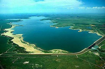
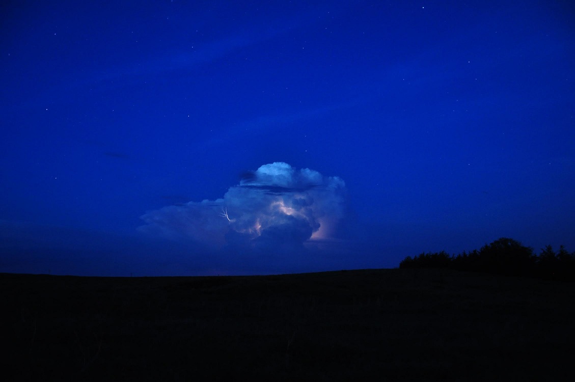
A high desert thunderstorm lights up the sky behind Glen Canyon Dam — Photo USBR
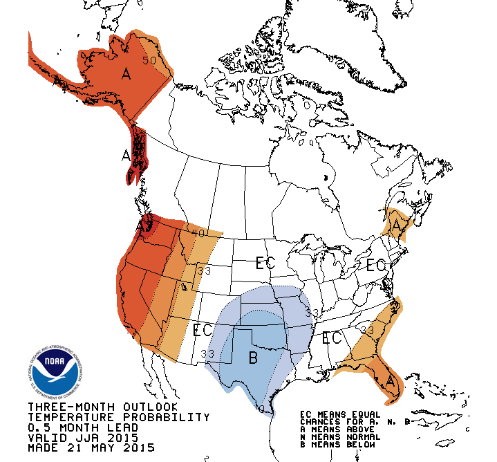
Precipitation Outlook May 21 thru August 31, 2015 via the Climate Prediction CenterTemperature Outlook May 21 thru August 31, 2015 via the Climate Prediction Center
Colorado transmountain diversions via the State Engineer’s office
Click through to listen to an interview with Jim Pokrandt from Aspen Public Radio (Marci Krinoven). Here’s an excerpt:
The commissioners are organizing a meeting of Western Slope elected leaders to draw up a unified message ahead of the completion of Governor Hickenlooper’s statewide water plan. Garfield County Commissioner Tom Jankovsky:
“You take Pitkin County and Garfield County – they’re miles apart philosophically on how things should be done. But, when it comes to transmountain diversions, we have the same mindset: no more water to go to the east slope.”
Seven-point draft conceptual agreement framework for negotiations on a future transmountain diversion screen shot December 18, 2014 via Aspen Journalism
Some water officials in the state have endorsed what’s called the “7 points of consensus.” It includes consideration of new transmountain diversions that would move Western Slope water east. Already, 13 major diversions move water through the mountains.
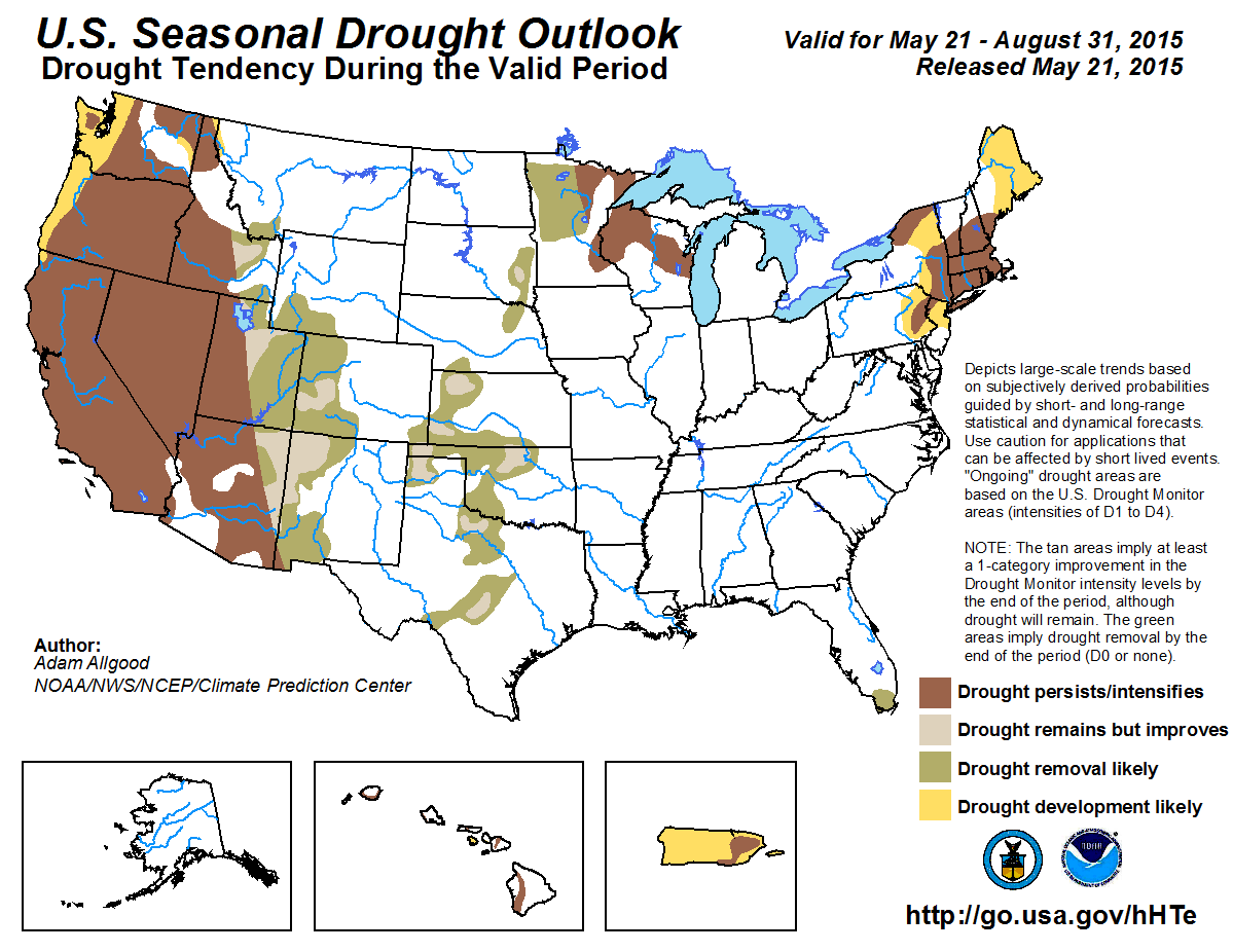
Click here to go to the US Drought Monitor website. Here’s an excerpt:
Summary
Nearly coast-to-coast storminess reduced drought’s footprint across the nation’s mid-section but triggered lowland flooding from the southeastern Plains and the western Gulf Coast region into the mid-South. Farther east, however, only light showers, if any, dampened the eastern U.S., except for some briefly heavy rain in the northern Mid-Atlantic region. In the Northeast, where little precipitation has fallen during the spring, another mostly dry week raised concerns about a lack of soil moisture and declining streamflows. Meanwhile, cool, wet weather in the upper Midwest provided much-needed moisture, following a period of rapid planting progress. In fact, below-normal temperatures dominated much of the country, with widespread freezes noted across the north-central U.S. from May 18-20. Elsewhere, broadly unsettled weather prevailed in the West, with the heaviest precipitation falling across the northern Intermountain region and the central and southern Rockies. The Western precipitation boosted topsoil moisture, aided winter grains, and reduced irrigation requirements. Beneficial showers dampened parts of California and Nevada, but failed to dent the Far West’s serious hydrological drought…
Great Plains
Frenetic weather led to further reductions in drought coverage. Late-season snow briefly blanketed several areas, including parts of North Dakota on May 17-18 and western Nebraska on May 19-20. Farther south, multiple rounds of heavy showers and locally severe thunderstorms led to flooding, particularly across the southeastern Plains. Several gauging points, including the Red River near DeKalb, Texas, and the Poteau River near Panama, Oklahoma, climbed to their highest levels since May 1990. The Red River near DeKalb rose 4.51 feet above flood stage on May 13, while the Poteau River near Panama surged 14.54 feet above flood stage on May 12. By May 20, cumulative storage in Texas’ reservoirs climbed to 24.78 million acre-feet (78.5% of capacity)—the highest in more than 4 years. Only a month ago, Texas’ storage was 22.53 million acre-feet, or 71.4% of capacity. Six months ago, on November 20, 2014, storage stood at just 19.43 million acre-feet, 62.0% of capacity.
On the southern Plains, month-to-date rainfall has already exceeded a foot in many locations, including Oklahoma City, Oklahoma (13.88 inches, or 508% of normal), and Wichita Falls, Texas (12.43 inches, or 570%). Record-high May totals in those two locations are 14.52 inches (in 2013) in Oklahoma City and 13.22 inches (in 1982) in Wichita Falls. In the Plains’ cotton belt, incessant rains have hampered fieldwork. For example, only 19% of Texas’ intended cotton acreage had been planted by May 17, compared to the 5-year average of 36%.
Farther north, spring precipitation arrived mostly too late to revive winter wheat but has aided rangeland, pastures, and summer crops. By May 17, roughly one-third of the winter wheat was rated in very poor to poor condition in South Dakota (36%), Nebraska (31%), and Kansas (30%). The damage to wheat was caused much earlier due to a combination of drought and winter weather extremes. Meanwhile, South Dakota’s rangeland and pastures—which were rated 33% very poor to poor on May 3, improved to 24% very poor to poor by May 17. Spring wheat, grown primarily in six Northern States from Washington to Minnesota, was off to a good start, with 65% of the crop rated good to excellent (and only 4% very poor to poor) on May 17…
West
Cool, occasionally showery weather across much of the western U.S. reduced irrigation demands, boosted topsoil moisture, and benefited rangeland, pastures, winter grains, and spring-sown crops. However, the late-season moisture failed to significantly alter the bleak hydrological situation in drought-affected areas, including California. By April 30, reservoir storage as a percent of average for the date was significantly below normal in Arizona, California, Nevada, New Mexico, and Oregon. Storage in California’s 154 reservoirs stood at 18.0 million acre-feet (64 percent of average) on May 1, about 1.6 million acre-feet lower than a year ago. With little snow in the mountains above California’s lakes, further inflow will be negligible, meaning that the reservoir recharge season has ended early.
An exception to the West’s cool, damp pattern was the Pacific Northwest, where abnormal dryness (D0) expanded to cover western Washington. During the first 19 days of May, rainfall totaled just 0.65 inch (20% of normal) in Quillayute, Washington. Farther inland, USDA on May 17 rated only a little more than one-third of the winter wheat crop in good to excellent in Washington (39%) and Oregon (34%). In addition to less-than-ideal crop conditions, snowpack and streamflows remain at extremely low levels in most of the Northwest. As a result, severe drought (D2) was introduced across portions of northeastern Washington and northern Idaho, while moderate drought (D1) was expanded. Farther south, recent precipitation has been heavy enough in southern Idaho to prevent significant drought expansion, although hydrological concerns persist.
Despite atypically heavy showers for May in California, Nevada, and Arizona, the drought depiction remained effectively unchanged. Simply stated, the late-season rain and snow showers have improved the appearance of the landscape but have left the underlying, long-term drought virtually untouched. Even with the showers, California’s topsoil moisture was rated 85% very short to short on May 17, while subsoil moisture was 90% very short to short. Similarly, Nevada’s topsoil moisture was 65% very short to short, while subsoil moisture was 85% very short to short. Nevertheless, locations reporting their wettest May day on record included San Diego, California (1.63 inches on May 14; previously, 1.49 inches on May 8, 1977), and Phoenix, Arizona (0.93 inch on May 15; previously, 0.91 inch on May 4, 1976).
More widespread precipitation has fallen in recent weeks across the central and southern Rockies and environs. In fact, the water content of the high-elevation snowpack climbed above the mid-May average in several river basins in the Rockies of Colorado and New Mexico. Due to the extensive precipitation, improved water-supply prospects, and boost in soil moisture, another round of sweeping improvements in the drought depiction were introduced in Colorado and New Mexico, extending northward into southern Wyoming and westward into eastern Utah. Through May 19, month-to-date precipitation has totaled 200 to 300% of normal in locations such as Grand Junction, Colorado; Salt Lake City, Utah; Denver, Colorado; and Evanston, Wyoming. Parts of New Mexico have been even wetter in recent weeks, relative to normal, with May 1-19 totals reaching 5.45 inches (524% of normal) in Clayton and 1.50 inches (484%) in Albuquerque…
Looking Ahead
During the next several days, a parade of storms will continue to emerge from the western U.S. As a result, 5-day precipitation totals could reach 1 to 2 inches from Oregon and northern California to the Intermountain West. Meanwhile, totals of 2 to 5 inches or more can be expected across the central and southern Plains and parts of the mid-South. In contrast, little or no rain will fall in the eastern U.S. and across the nation’s northern tier. Most of the country, excluding the Southeast and Northwest, will continue to experience cool weather.
The NWS 6- to 10-day outlook for May 26 – 30 calls for likelihood of above-normal temperatures along the Pacific Coast, in the Northwest, and east of the Mississippi River. Meanwhile, cooler-than-normal conditions will cover the central and southern High Plains and parts of the Southwest. A wet pattern will persist nearly nationwide, with drier-than-normal weather likely limited to the northern Pacific Coast, southern Florida, and a small area near the Canadian border centered on northern North Dakota.
From the Department of Interior (Jessica Kershaw/Peter Soeth/Albert Rodriguez/Tonya Durrell):
As part of the Obama Administration’s continued effort to bring relief to western communities suffering from the historic drought, U.S. Secretary of the Interior Sally Jewell today announced that Interior’s Bureau of Reclamation will invest nearly $50 million to improve water efficiency and conservation in California and 11 other western states.
“In a time of exceptional drought, it is absolutely critical that states and the federal government leverage our funding resources so that we can make each drop count,” said Secretary Jewell. “Being ‘water smart’ means working together to fund sustainable water initiatives that use the best available science to improve water conservation and help water resource managers identify strategies to narrow the gap between supply and demand.”
Joined by Nancy Sutley, Chief Sustainability and Economic Development Officer of the Los Angeles Department of Water and Power, the funding announcement was made today at the Donald C. Tillman Water Reclamation Plant in Van Nuys, CA, where millions of gallons of wastewater are purified each day. Secretary Jewell, Bureau of Reclamation Commissioner Estevan López and Sutley emphasized the importance of federal-state partnerships to help work toward a more sustainable and resilient water future.
“Through the WaterSMART Program, Reclamation is providing funding for water conservation improvements and water reuse projects across the West,” Reclamation Commissioner Estevan López said. “We commend the state of California for all the steps they have already taken to alleviate the impacts of the drought. We hope this federal funding for water reuse and efficiency will help us leverage scarce resources between the state and federal governments to bring much-needed relief for the people and environment of California.”
“The federal government’s support for critical water efficiency and reuse projects is most valuable especially during this historic drought in California,” said Sutley. “The investments will help cities like Los Angeles carry out our sustainability objectives, further build our local water supply and reduce our reliance on imported water. We look forward to all these important opportunities ahead of us.”
“We are honored to host Secretary Jewell at our Donald C. Tillman Water Reclamation Plant and Japanese Garden today,” said LA Sanitation Director Enrique C. Zaldivar, P.E. “We look forward to learning more about the environmental partnership opportunities she will announce during her visit.”
Reclamation is investing more than $24 million in grants for 50 water and energy efficiency projects in 12 western states, more than $23 million for seven water reclamation and reuse projects in California, and nearly $2 million for seven water reclamation and reuse feasibility studies in California and Texas.
WaterSMART is the U.S. Department of the Interior’s sustainable water initiative. Since it was established in 2010, WaterSMART has provided about $250 million in competitively-awarded funding to non-federal partners, including tribes, water districts, municipalities and universities. These investments have conserved enough water to meet the needs of more than 3.8 million people. Every acre-foot of conserved water delivered means that an equivalent amount of existing supplies is available for other uses.
WaterSMART water and energy efficiency grants can be used for projects that conserve and use water more efficiently, increase the use of renewable energy, improve energy efficiency, benefit endangered and threatened species, facilitate water markets, carry out activities to address climate-related impacts on water or prevent any water-related crisis or conflict. The 50 projects announced today will be leveraged with at least 50 percent non-federal funding for a total of $133 million in improvements over the next two to three years. For a complete description of the 50 projects, please visit the WaterSMART Water and Energy Efficiency Grant website.
Through Title XVI of the Reclamation Wastewater and Groundwater Study and Facilities Act, Reclamation provides funding for projects that reclaim and reuse municipal, industrial, domestic or agricultural wastewater and naturally impaired ground or surface waters. Title XVI provides up to 25 percent of project costs. Project sponsors provide the remaining 75 percent of the funding necessary to carry out projects, thereby leveraging limited federal funding to implement as many water reuse projects as possible. Seven projects in California will receive $23.2 million. For a complete description of these seven water reuse projects, please visit the WaterSMART Title XVI website.
Also under the Title XVI Act, Reclamation is providing $1.6 million for communities to study whether water reuse projects would help them to meet their future water needs. Four feasibility studies in California and three studies in Texas were selected this year. Feasibility studies are funded jointly by Reclamation and project sponsors. A cost-share of at least 50 percent of study is required. For a complete description of the seven new studies selected for funding, please visit the WaterSMART Title XVI website.
Water from this week’s rainfall is flowing into storage now, as farmers wait out the wet spell to get back into fields.
“What we need now is for it to quit raining and warm up,” said Rocky Ford farmer John Schweizer. “We’re happy for the rain, but it’s so wet we can’t do anything.”
Most canals were shut off during this week’s rains, and flows from Lake Pueblo were cut as the Arkansas River reached flood stage at Avondale. Flows at Avondale topped 10,000 cubic feet per second overnight Wednesday, more than 4,000 cfs above flood stage. Avondale remained above 6,000 cfs for most of the day Wednesday.
For farmers, there is still a lot of planting to do, particularly corn, which is grown for feed and a major cash crop in the Arkansas Valley.
“We got most of our stuff planted when it should be planted,” said Joe Mauro, who farms on the Bessemer Ditch in Pueblo County. “We put the corn and chiles in before this rain, and they’ll do well if the crust from this moisture isn’t too thick. We will put in pinto beans and pumpkins by June.”
In other parts of the valley, most crops are delayed.
“The stuff planted earlier hasn’t gotten up yet, and corn planting is delayed,” said Mike Bartolo, of the Colorado State University Research Center at Rocky Ford. “There was a window to get stuff in last weekend, but most of it should be planted. It’s a mixed bag, but it’s generally delayed.”
Even alfalfa — plants that winter over — has been problematic, Schweizer said.
Warm weather this year got it started early if it hadn’t been knocked back by dry, cold weather over the winter. But that brought out bugs, too. Farmers who have already sprayed for bugs have to spray again once temperatures warm up.
Because corn prices have dropped, some farmers in the Lamar area are planting milo, or sorghum, and even soybeans, crops that use less water and have a longer planting window, said Dale Mauch, who farms near Lamar.
“We’ve been dry for so long. Everything changed after May 1,” Mauch said. “This is the first time in a long time that you’ll be able to plant all your acres on all your land. It’s sure nice to see green country.”
Grasslands also are coming back, so those who nursed their cattle herds through the drought should be in good shape. Because of the shortage of cows, it will be expensive to rebuild herds that were culled, however.
The Colorado Canal, which is mostly owned by Colorado Springs and Aurora, and the Fort Lyon Canal were the only large ditches taking water Wednesday, because they can store it. Colorado Springs and Aurora were releasing water from Lake Meredith and leasing it to the Lower Arkansas Water Management Association and Colorado Parks and Wildlife, Division 2 Engineer Steve Witte said.
Combined, the ditches took about 1,280 cfs of water.
The rest is being stored in John Martin Reservoir under conservation storage, or in the Amity Canal account in lieu of flowing into the Great Plains reservoirs via the Fort Lyon storage canal. John Martin storage has increased from about 6,300 acrefeet in November to 80,000 acre-feet. Water in conservation storage is used for later release in Colorado and to satisfy Kansas demands for water at the state line, so any water stored by Colorado farmers carries a 35 percent surcharge.
Witte couldn’t say how much water will be contributed to John Martin during this event, since there were delayed flows yet to come from the Purgatoire and Huerfano Rivers, as well as Fountain Creek. More rainfall is expected through the weekend throughout the area.
John Martin Reservoir back in the day
FromThe Pueblo Chieftain (Tracy Harmon/Matt Hildner):
Water levels at the reservoir have risen significantly, leading to changes that will impact guests and those planning on visiting in the near future. According to Colorado Parks and Wildlife spokeswoman Abbie Walls, most areas on the south side of the reservoir are under water, so areas where trailers can be parked will be limited…
John Martin Reservoir gained almost 27,000 acre feet of water in the past week due to storms. As of Monday, the reservoir had 77,600 acre feet of water and was still rising, compared to about 31,000 acre feet and dropping last year at this time.


